Effective Date: 30 June 2026
Final Report Date: 30 October 2026

HARMONY GOLD MINING COMPANY LIMITED
Technical Report Summary of the
Mineral Resources and Mineral Reserves
for
Tshepong North
Free State Province, South Africa
Effective Date: 30 June 2026
ii
Technical Report Summary for
Tshepong North, Free State Province, South Africa
IMPORTANT NOTICE This Technical Report Summary (“TRS”) has been prepared for Harmony Gold Mining Company Limited in support of disclosure and filing requirements with the United States Securities and Exchange Commission (“SEC”) under Subpart 1300 of Regulation S-K and Section 229.601(b)(96) of Regulation S-K. The quality of information, estimates, and conclusions contained in this Technical Report Summary apply as of the effective date of this report. Subsequent events that may have occurred since that date may have resulted in material changes to such information, estimates and conclusions in this summary. |
Effective Date: 30 June 2026
iii
Technical Report Summary for
Tshepong North, Free State Province, South Africa
Qualified Person Consent and Sign-off
I have read and understood the requirements of:
•the South African Code for Reporting of Exploration Results, Mineral Resources and Mineral Reserves (the
“SAMREC Code, 2016 edition”)
•the Harmony Guidelines on the Reporting of Exploration Results, Mineral Resources and Mineral Reserves
•Subpart 1300 (17 CFR 229.1300) of Regulation S-K, Disclosure by Registrants Engaged in Mining Operations
(“Regulation S-K 1300”)
I am a Competent Person as defined by the SAMREC Code, 2016 edition and the Qualified Person (“QP”) under
Regulation S-K 1300, having more than five years` experience that is relevant to the style of mineralization and type of
deposit described in the Report, and to the all the activities for which I am accepting responsibility and have been
appointed as QP for Tshepong North Mineral Resources and Mineral Reserves.
I am a Member of SACNASP and my registration is as follows:
Mineral Resource
Andrew Louw
SACNASP (South African Council for Natural Scientific Professions)
Nr 136445
Years’ Experience: 30
I have reviewed the tables and graphs included for Tshepong North Mineral Resource and Mineral Reserve which will be
used in the 2026 Harmony Gold Mining Company Limited Mineral Resource and Mineral Reserve Report to which this
Consent Statement applies.
I acknowledge responsibility for all the Sections of the TRS report and as the QP and author I relied on information
provided by various subject experts.
At the effective date of the Report, to the best of my knowledge, information and belief, the Report contains all
scientific and technical information that is required to be disclosed to make the Report not misleading.
/s/ Andrew Louw
___________________________________
Mr Andrew Louw
B.Sc (Hons) Geo Hydrology, CEE Diploma
SACNASP (No. 136445)
Ore Reserve Manager, Tshepong North
Harmony Gold Mining Company Limited
Effective Date: 30 June 2026
iv
Technical Report Summary for
Tshepong North, Free State Province, South Africa
List of Contents
1Executive Summary ...................................................................................................................................... | |
2Introduction ................................................................................................................................................... | |
3Property Description and Location ............................................................................................................... | |
3.1Mineral Tenure ............................................................................................................................... | |
3.2Property Permitting Requirements ................................................................................................ | |
4Accessibility, Climate, Local Resources, Infrastructure and Physiography ................................................... | |
4.1Accessibility .................................................................................................................................... | |
4.2Physiography and Climate .............................................................................................................. | |
4.3Local Resources and Infrastructure ................................................................................................ | |
5.1Historical Ownership and Development ........................................................................................ | |
5.2Historical Exploration ..................................................................................................................... | |
5.3Previous Mineral Resource and Mineral Reserve Estimates .......................................................... | |
5.4Past Production .............................................................................................................................. | |
6Geological Setting, Mineralization and Deposit ............................................................................................ | |
6.1Regional Geology ............................................................................................................................ | |
6.2Local Geology .................................................................................................................................. | |
6.3Property Geology ............................................................................................................................ | |
6.3.1Basal Reef Lithology ......................................................................................................... | |
6.3.2B Reef Lithology ............................................................................................................... | |
6.4Mineralization ................................................................................................................................. | |
6.4.1Basal Reef ........................................................................................................................ | |
6.4.3Alteration ......................................................................................................................... | |
6.5Deposit Type ................................................................................................................................... | |
6.6Commentary on Geological Setting, Mineralization and Deposit .................................................. | |
7Exploration .................................................................................................................................................... | |
7.1Geophysical Surveys ....................................................................................................................... | |
7.2Topographic Surveys ...................................................................................................................... | |
7.3Underground Mapping ................................................................................................................... | |
7.4Channel Sampling Methods and Sample Quality ........................................................................... | |
7.5Surface Drilling Campaigns, Procedures, Sampling, Recoveries and Results ................................. | |
7.5.1Drilling Methods .............................................................................................................. | |
7.5.2Collar and Downhole Surveys .......................................................................................... | |
7.5.3Logging Procedures .......................................................................................................... | |
7.5.4Drilling Results ................................................................................................................. | |
7.5.5Core Recovery .................................................................................................................. | |
7.5.6Sample Length and True Thickness ................................................................................. | |
7.6Underground Drilling Campaigns, Procedures and Sampling ........................................................ | |
7.6.1Drilling Methods .............................................................................................................. | |
7.6.2Collar and Downhole Surveys .......................................................................................... | |
7.6.3Logging Procedures .......................................................................................................... | |
7.6.4Drilling Results ................................................................................................................. | |
7.6.5Core Recovery .................................................................................................................. | |
7.6.6Sample Length and True Thickness ................................................................................. | |
7.7Hydrogeology .................................................................................................................................. | |
7.8Geotechnical Data .......................................................................................................................... | |
7.9Commentary on Exploration .......................................................................................................... | |
8Sample Preparation, Analyses and Security .................................................................................................. |
Effective Date: 30 June 2026
v
Technical Report Summary for
Tshepong North, Free State Province, South Africa
8.1Sampling Method and Approach .................................................................................................... | |
8.1.1Channel Samples .............................................................................................................. | |
8.1.2Core Samples ................................................................................................................... | |
8.2Density Determination ................................................................................................................... | |
8.3Sample Security .............................................................................................................................. | |
8.4Sample Storage ............................................................................................................................... | |
8.5Laboratories Used ........................................................................................................................... | |
8.6Laboratory Sample Preparation ..................................................................................................... | |
8.7Assaying Methods and Analytical Procedures................................................................................ | |
8.8.1Certified Reference Material ........................................................................................... | |
8.8.3Duplicates ........................................................................................................................ | |
8.9Comment on Sample Preparation, Analyses and Security ............................................................. | |
9Data verification ............................................................................................................................................ | |
9.2Data Verification Procedures .......................................................................................................... | |
9.3Limitations to the Data Verification ............................................................................................... | |
9.4Comment on Data Verification ....................................................................................................... | |
10Mineral Processing and Metallurgical Testing .............................................................................................. | |
10.1Introduction .................................................................................................................................... | |
10.2Sampling and Testing Methodologies ............................................................................................ | |
10.2.1Systematic and Continuous Sampling .............................................................................. | |
10.2.2Composite Sampling ........................................................................................................ | |
10.2.3Calibration and Verification of Equipment ...................................................................... | |
10.2.4Specific Testing Procedures ............................................................................................. | |
10.2.5Analytical Laboratories .................................................................................................... | |
10.3Data Validation and Quality Control .............................................................................................. | |
10.3.1Statistical Analysis ............................................................................................................ | |
10.3.2Continuous Improvement ................................................................................................ | |
10.4Recovery Estimates and Processing Factors ................................................................................... | |
10.4.1Detailed Calculation of Recovery Estimates .................................................................... | |
10.4.2Head Grade and Residue Grade ...................................................................................... | |
10.4.3Adjustments for Solution and Carbon Adsorption .......................................................... | |
10.4.4Integration of Bottle Roll Tests for Baseline Recovery Rates .......................................... | |
10.4.5Processing Factors Affecting Recovery ............................................................................ | |
10.4.6Gold Inventory Management and Accountability ........................................................... | |
10.5Conclusion ...................................................................................................................................... | |
11Mineral Resource Estimate ........................................................................................................................... | |
11.1Geological Database ....................................................................................................................... | |
11.2Global Statistics .............................................................................................................................. | |
11.3Geological Interpretation ............................................................................................................... | |
11.4Structural Wireframe Model .......................................................................................................... | |
11.5Compositing .................................................................................................................................... | |
11.7Variography .................................................................................................................................... | |
11.8Mineral Resource Estimation Methods and Parameters ............................................................... | |
11.9Density Assignment ........................................................................................................................ | |
11.10Model Validation ............................................................................................................................ | |
11.11Mineral Resource Evaluation .......................................................................................................... | |
11.12Mineral Resource Classification and Uncertainties ........................................................................ |
Effective Date: 30 June 2026
vi
Technical Report Summary for
Tshepong North, Free State Province, South Africa
11.13Mineral Resource Estimate ............................................................................................................ | |
11.14Mineral Resource Reconciliation .................................................................................................... | |
11.15Comment on Mineral Resource Estimates ..................................................................................... | |
12Mineral Reserve Estimate ............................................................................................................................. | |
12.1Tshepong North .............................................................................................................................. | |
12.1.2Modifying Factors ............................................................................................................ | |
12.1.3Mineral Reserve Estimate ................................................................................................ | |
12.1.4Mineral Reserve Reconciliation ...................................................................................... | |
12.2Commentary on Mineral Reserve Estimate ................................................................................... | |
13Mining Methods ............................................................................................................................................ | |
13.1Mining Operations .......................................................................................................................... | |
13.1.1Tshepong North ............................................................................................................... | |
13.1.2Sequential Grid Mining (“SGM”) ...................................................................................... | |
13.1.3Open Stoping ................................................................................................................... | |
13.1.4Breast Mining ................................................................................................................... | |
13.1.5Integrated Approach ........................................................................................................ | |
13.2Mine Design .................................................................................................................................... | |
13.2.1Mine Design Parameters ................................................................................................. | |
13.3Geotechnical Considerations and Seismic Monitoring ................................................................... | |
13.4Geohydrological Considerations ..................................................................................................... | |
13.5Mine Plan Development and Schedule .......................................................................................... | |
13.6Mining Rates ................................................................................................................................... | |
13.7Grade and Dilution Control ............................................................................................................ | |
13.8Mining Equipment and Machinery ................................................................................................. | |
13.9Ore transport .................................................................................................................................. | |
13.10Mining Personnel ............................................................................................................................ | |
13.11Commentary on Mining Methods .................................................................................................. | |
14Processing and Recovery Methods ............................................................................................................... | |
14.1Mineral Processing Description ...................................................................................................... | |
14.2Plant Throughput, Design, Equipment Characteristics and Specifications .................................... | |
14.3Energy, Water, Process Material and Personnel Requirements .................................................... | |
14.3.3Process Material .............................................................................................................. | |
14.4Commentary on the Processing and Recovery Methods ............................................................... | |
15Infrastructure ................................................................................................................................................ | |
15.1Surface Infrastructure ..................................................................................................................... | |
15.1.1Ore and Waste Rock Storage Facilities ............................................................................ | |
15.1.2Tailings Storage Facilities ................................................................................................. | |
15.2Underground Infrastructure and Shafts ......................................................................................... | |
15.3Power and Electrical ....................................................................................................................... | |
15.4Water Usage ................................................................................................................................... | |
15.5Logistics and Supply ........................................................................................................................ | |
15.6Commentary on Infrastructure ...................................................................................................... | |
16Market Studies .............................................................................................................................................. | |
16.1Market Overview ............................................................................................................................ | |
16.2Global Production and Supply ........................................................................................................ | |
16.2.1New Mine Production ...................................................................................................... |
Effective Date: 30 June 2026
vii
Technical Report Summary for
Tshepong North, Free State Province, South Africa
16.3Global Consumption and Demand ................................................................................................. | |
16.3.2Investment ....................................................................................................................... | |
16.3.3The USD Currency and Gold............................................................................................. | |
16.4Gold Price ........................................................................................................................................ | |
16.4.1Historical Gold Price ......................................................................................................... | |
16.4.2Forecast Gold Price .......................................................................................................... | |
16.4.3Harmony Group Gold Hedging Policy .............................................................................. | |
16.5Commentary on Market Studies .................................................................................................... | |
16.6Material Contracts .......................................................................................................................... | |
17Environmental Studies, Permitting and Plans, Negotiations, or Agreements with Local Individuals or Groups ........................................................................................................................................................... | |
17.1Results of Environmental Studies ................................................................................................... | |
17.2Waste and Tailings Disposal, Monitoring & Water Management .................................................. | |
17.3Permitting and Licenses .................................................................................................................. | |
17.4Local Stakeholder Plans and Agreements ...................................................................................... | |
17.5Mine Closure Plans ......................................................................................................................... | |
Groups ............................................................................................................................................ | |
17.7Local Procurement and Hiring ........................................................................................................ | |
with Local Individuals or Groups .................................................................................................... | |
18Capital and Operating Costs .......................................................................................................................... | |
18.1Capital Costs ................................................................................................................................... | |
18.2Operating Costs .............................................................................................................................. | |
18.3Comment on Capital and Operating Costs ..................................................................................... | |
19Economic Analysis ........................................................................................................................................ | |
19.1Key Economic Assumptions and Parameters ................................................................................. | |
19.1.1Gold Price ......................................................................................................................... | |
19.1.2Exchange Rate .................................................................................................................. | |
19.2Economic Analysis .......................................................................................................................... | |
19.3Sensitivity Analysis .......................................................................................................................... | |
20Adjacent properties ....................................................................................................................................... | |
21Other Relevant Data and Information .......................................................................................................... | |
22Interpretation and Conclusions ..................................................................................................................... | |
23Recommendations ....................................................................................................................................... | |
24References ..................................................................................................................................................... | |
25Reliance on Information Provided by the Registrant .................................................................................... |
Effective Date: 30 June 2026
viii
Technical Report Summary for
Tshepong North, Free State Province, South Africa
List of Figures
Effective Date: 30 June 2026
ix
Technical Report Summary for
Tshepong North, Free State Province, South Africa
List of Tables
Effective Date: 30 June 2026
x
Technical Report Summary for
Tshepong North, Free State Province, South Africa
Units of Measure and Abbreviations
Unit / Abbreviation | Description or Definition |
°C | degrees Celsius |
µm | Micrometers |
2D | Two-dimensional |
3D | Three-dimensional |
AE | Abnormal expenditure |
Ag | Silver |
AngloGold Ashanti | AngloGold Ashanti Limited |
ARM | African Rainbow Minerals Limited |
ARMGold | ARM Gold Division |
Au | Gold |
AuBIS | Harmony electronic database |
Ave. | Average |
BLR | Black Reef |
BMD | Below mine datum |
Bn | Billion |
c. | Approximately |
CIP | Carbon-In-Pulp |
CLR | Carbon Leader Reef |
cm | Centimetre |
cmg/t | Centimetre-grams per tonne |
CODM | Chief Operating Decision-Maker |
Company | Harmony Gold Mining Company Limited |
COP | Code of Practice |
CRG | Central Rand Group |
CRM | Certified Reference Material |
CV | Coefficient of Variation |
DBH | Dewatering borehole |
DMPR | Department of Mineral Resources and Energy |
DWS | Department of Water and Sanitation |
EIA | Environmental Impact Assessment |
EMPR | Environmental Management Program |
EMS | Environmental Management System |
EMTS | Electric Monorail Transport System |
ESG | Environmental Social and Governance |
ETF | Exchange traded fund |
FAG | Fully autogenous |
FX | Foreign Exchange rate |
g | Gram |
g/t | Grams per metric tonne |
GBH | Groundwater boreholes |
GDARD | Gauteng Department of Agriculture and Rural Development |
GHG | Greenhouse gas |
GISTM | Global Industry Standard on Tailings Management |
ha | Hectare |
Harmony | Harmony Gold Mining Company Limited |
HLS | Heavy liquid separation |
HPE | Hydro-powered |
kg | Kilogram |
km | Kilometre |
Effective Date: 30 June 2026
xi
Technical Report Summary for
Tshepong North, Free State Province, South Africa
Unit / Abbreviation | Description or Definition |
km2 | Square kilometre |
kWh | Kilowatt-hour |
LBMA | London Bullion Market Association |
LIB | Long Inclined Borehole |
LOM | Life of Mine |
LOI | Loss on ignition |
Ltd | Limited |
m | Meter |
M | Million |
m3/hr | Cubic meters per hour |
MCC | Mining Charter Compliance |
MCF | Mine Call Factor |
Moz | Million troy ounces |
MPRDA | Mineral and Petroleum Resources Development Act, 28 of 2002 |
Mst | Million short tons |
Mt | Million tonnes |
Mtpa | Million tonnes per annum |
Mtpm | Million tonnes per month |
NEMA | National Environmental Management Act, 107 of 1998 |
No. | Number |
NPV | Net present value |
oz | Troy ounce |
OTC | Over the counter |
Phakisa | Phakisa Mine, also known as Tshepong South |
Pty | Proprietary |
QA/QC | Quality Assurance/Quality Control |
QEMSCAN | Scanning electron microscope |
QP | Qualified Person |
ROM | Run-of-Mine |
SACNASP | South African Council for Natural Scientific Professions |
SAMREC | The South African Code for the Reporting of Exploration Results, Mineral Resources and Mineral Reserves |
SD | Standard Deviation |
SEC | Securities and Exchange Commission |
SGM | Sequential Grid Mining |
SLP | Social Labour Plan |
st | Short ton |
t | Metric tonne |
t/m3 | Tonne per cubic meter |
Target | Target Mine |
TCFD | Task Force on Climate-Related Financial Disclosure |
TMS | Trace mineral search |
TRS | Technical Report Summary |
TSF | Tailings Storage Facility |
Tshepong | Tshepong Mine, also known as Tshepong North |
USD | United States Dollars |
USD/oz | United States Dollar per troy ounce |
WRG | West Rand Group |
WULA(s) | Water Use Licence Application(s) |
XRD | X-ray diffraction |
Effective Date: 30 June 2026
xii
Technical Report Summary for
Tshepong North, Free State Province, South Africa
Unit / Abbreviation | Description or Definition |
ZAR | South African Rand |
ZAR/kg | South African Rand per kilogram |
Effective Date: 30 June 2026
xiii
Technical Report Summary for
Tshepong North, Free State Province, South Africa
Glossary of Terms
Term | Definition |
Co-kriging | A method that is used to predict the value of the point at unobserved locations by sample points that are known to be spatially interconnected by adding other variables that have a correlation with the main variable or can also be used to predict 2 or more variables simultaneously. |
Cut-off grade | Cut-off grade is the grade (i.e., the concentration of metal or mineral in rock) that determines the destination of the material during mining. For purposes of establishing “prospects of economic extraction,” the cut-off grade is the grade that distinguishes material deemed to have no economic value (it will not be mined in underground mining or if mined in surface mining, its destination will be the waste dump) from material deemed to have economic value (its ultimate destination during mining will be a processing facility). Other terms used in similar fashion as cut-off grade include net smelter return, pay limit, and break-even stripping ratio. |
Dilution | Unmineralized rock that is by necessity, removed along with ore during the mining process that effectively lowers the overall grade of the ore. |
Head grade | The average grade of ore fed into the mill. |
Economically viable | Economically viable, when used in the context of Mineral Reserve determination, means that the qualified person has determined, using a discounted cash flow analysis, or has otherwise analytically determined, that extraction of the Mineral Reserve is economically viable under reasonable investment and market assumptions. |
Indicated Mineral Resource | Indicated Mineral Resource is that part of a Mineral Resource for which quantity and grade or quality are estimated on the basis of adequate geological evidence and sampling. The level of geological certainty associated with an Indicated Mineral Resource is sufficient to allow a qualified person to apply modifying factors in sufficient detail to support mine planning and evaluation of the economic viability of the deposit. Because an Indicated Mineral Resource has a lower level of confidence than the level of confidence of a Measured Mineral Resource, an Indicated Mineral Resource may only be converted to a probable Mineral Reserve. |
Inferred Mineral Resource | Inferred Mineral Resource is that part of a Mineral Resource for which quantity and grade or quality are estimated on the basis of limited geological evidence and sampling. The level of geological uncertainty associated with an Inferred Mineral Resource is too high to apply relevant technical and economic factors likely to influence the prospects of economic extraction in a manner useful for evaluation of economic viability. Because an Inferred Mineral Resource has the lowest level of geological confidence of all Mineral Resources, which prevents the application of the modifying factors in a manner useful for evaluation of economic viability, an Inferred Mineral Resource may not be considered when assessing the economic viability of a mining project and may not be converted to a Mineral Reserve. |
Kriging | A method of interpolation based on Gaussian process governed by prior covariances. It uses a limited set of sampled data points to estimate the value of a variable over a continuous spatial field |
Mine Call Factor | The ratio, expressed as a percentage, of the total quantity of recovered and unrecovered mineral product after processing with the amount estimated in the ore based on sampling. |
Measured Mineral Resource | Measured Mineral Resource is that part of a Mineral Resource for which quantity and grade or quality are estimated on the basis of conclusive geological evidence and sampling. The level of geological certainty associated with a Measured Mineral Resource is sufficient to allow a qualified person to apply modifying factors, as defined in this section, in sufficient detail to support detailed mine planning and final evaluation of the economic viability of the deposit. Because a Measured Mineral Resource has a higher level of confidence than the level of confidence of either an Indicated Mineral Resource or an Inferred Mineral Resource, a Measured Mineral Resource may be converted to a Proven Mineral Reserve or to a Probable Mineral Reserve. |
Mineral Reserve | Mineral Reserve is an estimate of tonnage and grade or quality of Indicated and Measured Mineral Resources that, in the opinion of the qualified person, can be the basis of an economically viable project. More specifically, it is the economically mineable part of a Measured or Indicated Mineral Resource, which includes diluting materials and allowances for losses that may occur when the material is mined or extracted. |
Mineral Resource | Mineral Resource is a concentration or occurrence of material of economic interest in or on the Earth’s crust in such form, grade or quality, and quantity that there are reasonable prospects for eventual economic extraction. A Mineral Resource is a reasonable estimate of mineralization, taking into account relevant factors such as cut- off grade, likely mining dimensions, location or continuity, that, with the assumed and justifiable technical and economic conditions, is likely to, in whole or in part, become economically extractable. It is not merely an inventory of all mineralization drilled or sampled. |
Effective Date: 30 June 2026
xiv
Technical Report Summary for
Tshepong North, Free State Province, South Africa
Term | Definition |
Modifying Factors | Modifying factors are the factors that a qualified person must apply to Indicated and Measured Mineral Resources and then evaluate in order to establish the economic viability of Mineral Reserves. A qualified person must apply and evaluate modifying factors to convert Measured and Indicated Mineral Resources to Proven and Probable Mineral Reserves. These factors include but are not restricted to; mining; processing; metallurgical; infrastructure; economic; marketing; legal; environmental compliance; plans, negotiations, or agreements with local individuals or groups; and governmental factors. The number, type and specific characteristics of the modifying factors applied will necessarily be a function of and depend upon the mineral, mine, property, or project. |
Pre-Feasibility Study | A pre-feasibility study (or preliminary feasibility study) is a comprehensive study of a range of options for the technical and economic viability of a mineral project that has advanced to a stage where a qualified person has determined (in the case of underground mining) a preferred mining method, or (in the case of surface mining) a pit configuration, and in all cases has determined an effective method of mineral processing and an effective plan to sell the product. (1) A pre-feasibility study includes a financial analysis based on reasonable assumptions, based on appropriate testing, about the modifying factors and the evaluation of any other relevant factors that are sufficient for a qualified person to determine if all or part of the Indicated and Measured Mineral Resources may be converted to Mineral Reserves at the time of reporting. The financial analysis must have the level of detail necessary to demonstrate, at the time of reporting, that extraction is economically viable. (2) A pre-feasibility study is less comprehensive and results in a lower confidence level than a feasibility study. A pre-feasibility study is more comprehensive and results in a higher confidence level than an initial assessment. |
Probable Mineral Reserve | Probable Mineral Reserve is the economically mineable part of an Indicated and, in some cases, a Measured Mineral Resource. |
Proven Mineral Reserve | Proven Mineral Reserve is the economically mineable part of a Measured Mineral Resource and can only result from conversion of a Measured Mineral Resource. |
Qualified Person | A qualified person is: (1) A mineral industry professional with at least five years of relevant experience in the type of mineralization and type of deposit under consideration and in the specific type of activity that person is undertaking on behalf of the registrant; and (2) An eligible member or licensee in good standing of a recognized professional organization at the time the technical report is prepared. For an organization to be a recognized professional organization, it must: (i) Be either: (A) An organization recognized within the mining industry as a reputable professional association; or (B) A board authorized by U.S. federal, state or foreign statute to regulate professionals in the mining, geoscience or related field; (ii) Admit eligible members primarily on the basis of their academic qualifications and experience; (iii) Establish and require compliance with professional standards of competence and ethics; (iv) Require or encourage continuing professional development; (v) Have and apply disciplinary powers, including the power to suspend or expel a member regardless of where the member practices or resides; and (vi) Provide a public list of members in good standing. |
Tailings | Finely ground rock of low residual value from which valuable minerals have been extracted is discarded and stored in a designed dam facility. |
Effective Date: 30 June 2026
1
Technical Report Summary for
Tshepong North, Free State Province, South Africa
1Executive Summary
Section 229.601(b)(96)(iii)(B)(1)
The QP of Harmony Gold Mining Company Limited (“Harmony” or the “Company”) has prepared this
Technical Report Summary (“TRS”) to disclose the Mineral Resource and Mineral Reserve estimates for the
Company’s Tshepong North. The TRS has been prepared in accordance with the U.S. Securities and Exchange
Commission’s (“SEC”) Regulation S-K 1300, with an effective date as at 30 June 2026. No material changes
have occurred between the effective date and the date of signature of this TRS.
This TRS updates the TRS filed by Harmony on Tshepong North on October 31, 2024, named Exhibit 96.12
Technical Report Summary of the Mineral Resources and Mineral Reserves for Tshepong North, Free State
Province, South Africa, which was effective on June 30, 2024 . This TRS is being filed to satisfy the
requirement of Item 1302(b)(2)(i) of Regulation S-K. An economic assessment was included, using a detailed
discounted cashflow analysis for the Mineral Reserves, excluding all scheduled Inferred Mineral Resources
which are not reported under Mineral Reserves.
Property Description
Tshepong North comprise the underground and surface assets, situated between the towns of Welkom and
Odendaalsrus in the Free State Province of South Africa. The mine is a moderate to deep-level gold mine,
operating at depths of between 1.6km and 2.4km below mine datum (“BMD”). The primary reef mined is the
Basal Reef, with additional gold mineralization being found in the B Reef and A Reef.
Mining at Tshepong North is carried out under the following mining right, covering both Tshepong North and
Tshepong South:
•FS30/5/1/84MR, which is valid from December 11, 2007 to December 10, 2029 and covers an area of
10,798.74 hectares (“ha”).
The mining right is held in a joint venture between African Rainbow Minerals Limited (“ARM”) Gold Division
(“ARMGold”) and Harmony.
All relevant underground mining and surface right permits, and any other permit related to the work
conducted on the property have been obtained and are valid. There are no known legal proceedings
(including violations or fines) against Harmony, which threaten its mineral rights, tenure, or operations.
Ownership
Tshepong North is wholly owned by Harmony, including the associated mineral rights. Harmony commenced
acquiring the assets through the acquisition of AngloGold Ashanti Limited’s (“AngloGold Ashanti”) Free State
operations in 2001, together with ARMGold. ARMGold was subsequently incorporated into Harmony in 2003,
giving Harmony 100% ownership and control of Tshepong North.
Geology and Mineralization
Tshepong North is situated in the Free State Goldfield, on the southwestern margin of the Witwatersrand
Basin of South Africa, one of the most prominent gold provinces in the world. The major gold bearing
conglomerate reefs are mostly confined to the Central Rand Group (“CRG”) of the Witwatersrand
Supergroup.
The general orientation of the Witwatersrand Supergroup succession in this goldfield is interpreted as north-
trending, within a syncline that is plunging to the north. The syncline has been divided by faults into the
Odendaalsrus, Central Horst and Virginia sections. The Tshepong North mining right area is also affected by
the Ophir and Dagbreek faults.
Tshepong North primarily exploits the Basal Reef, which occurs within the Harmony Formation of the
Johannesburg Subgroup of the CRG and during recent years the B Reef has been extensively exploited and
explored.
Effective Date: 30 June 2026
2
Technical Report Summary for
Tshepong North, Free State Province, South Africa
Mineralization also occurs within the stratigraphically higher A and B Reefs respectively of the Aandenk and
Spes Bona Formations, within the Turffontein subgroup of the CRG. However, only the B Reef can be
economically extracted.
Mineralization is associated with the presence of medium to coarse, clast-supported oligomictic pebble
horizons. The presence of allogenic pyrite and detrital carbon is also common.
Effective Date: 30 June 2026
3
Technical Report Summary for
Tshepong North, Free State Province, South Africa
Status of Exploration, Development and Operation
The Basal Reef at Tshepong North has been continuously and extensively explored. For the past 18 years B
Reef has also drawn attention for its economic viability and erratic nature of mineralized depositional zones
with the main focus on improving confidence in the geological model, as well as adding and upgrading
Mineral Resources to replace the mining depletion. Geological data has been obtained through underground
chip sampling in stope faces as well as on reef development raises and from underground geological mapping
of stope faces, haulages, cross cuts and on reef development raises. Initial exploration included a historical
geophysical seismic survey and surface diamond core drilling. This was followed by more closely spaced
underground data gathering exercises.
Mineral Resource Estimate
The Mineral Resources for the Basal Reef and B Reef were estimated by the Harmony QP in Datamine™
Studio software. The QP created block models based on a verified electronic database containing surface drill
hole data, as well as underground drilling, mapping, and sampling data obtained up until December 2025.
Gold values were estimated using ordinary and simple macro kriging interpolation methods.
The Mineral Resources for Tshepong North were originally prepared, classified and reported according to the
South African Code for the Reporting of Exploration Results, Mineral Resources and Mineral Reserves
(“SAMREC, 2016”). For the purposes of this TRS, the Mineral Resources have been classified in accordance
with § 229.1302(d)(1)(iii)(A) (Item 1302(d)(1)(iii)(A) of Regulation S-K) which is similar to the SAMREC 2016
classification, by the QP.
The QP compiling the Mineral Resource estimate for Tshepong North is Mr Andrew Louw, Ore Reserve
Manager at Tshepong North and an employee of Harmony.
The Mineral Resource estimate for Tshepong North, as at 30 June 2026 exclusive of the reported Mineral
Reserves is summarized in Table 1-1.
Table 1-1: Summary of Tshepong North Mineral Resources as at 30 June 2026 (Exclusive of Mineral Reserves) 1-8
METRIC | |||
Mineral Resource Category | Tonnes (Mt) | Gold Grade (g/t) | Gold Content (kg) |
Measured | 11.385 | 11.87 | 135,110 |
Indicated | 4.956 | 12.31 | 60,986 |
Total / Ave. Measured + Indicated | 16.341 | 12.00 | 196,096 |
Inferred | 7.578 | 10.20 | 77,309 |
IMPERIAL | |||
Mineral Resource Category | Tons (Mst) | Gold Grade (oz/st) | Gold Content (Moz) |
Measured | 12.550 | 0.346 | 4.344 |
Indicated | 5.463 | 0.359 | 1.961 |
Total / Ave. Measured + Indicated | 18.013 | 0.350 | 6.305 |
Inferred | 8.354 | 0.298 | 2.486 |
Notes:
1. Mineral Resources are reported with an effective date of 30 June 2026 and were originally prepared, classified and reported according
to SAMREC, 2016. For the purposes of this TRS, the Mineral Resources have been classified in accordance with § 229.1302(d)(1)(iii)(A)
(Item 1302(d)(1)(iii)(A) of Regulation S-K). The QP responsible for the estimate is Mr A Louw, who is Ore Reserve Manager at Tshepong
North, and a Harmony employee.
2. The Mineral Resource tonnes are reported as in-situ with reasonable prospects for eventual economic extraction.
3. The Mineral Resources are reported using a cut-off value of 661cmg/t determined at a gold price of USD3,061/oz.
4. Tonnes are reported as rounded to three decimal places. Gold values are rounded to zero decimal places.
5. Mineral Resources are exclusive of Mineral Reserves. Mineral Resources are not Mineral Reserves and do not necessarily demonstrate
economic viability.
6. Rounding as required by reporting guidelines may result in apparent summation differences.
7. The Mineral Resource estimate is for Harmony’s 100% interest.
Mineral Reserve Estimate
Mineral Reserves are derived from the Mineral Resources, a detailed business plan and the operational mine
planning processes. Mine planning utilises and takes into consideration historical technical parameters
achieved. In addition, Mineral Resource conversion to Mineral Reserves considers Modifying Factors,
dilution, ore losses, minimum mining widths, planned mine call.
Effective Date: 30 June 2026
4
Technical Report Summary for
Tshepong North, Free State Province, South Africa
The Mineral Reserves for Tshepong North were originally prepared, classified and reported according to
SAMREC, 2016. For the purposes of this TRS, the Mineral Reserves have been classified in accordance with
§ 229.1302(e)(2) (Item 1302(e)(2) of Regulation S-K). The Mineral Reserve estimate for Tshepong North, as at
30 June 2026, is summarized in Table 1-2.
Table 1-2: Summary of Tshepong North Mineral Reserves as at 30 June 2026 1-5
METRIC | |||
Mineral Reserve Category | Tonnes (Mt) | Gold Grade (g/t) | Gold Content (kg) |
Proved | 4.143 | 5.26 | 21,772 |
Probable | 6.423 | 4.96 | 31,828 |
Total (Proved + Probable) | 10.566 | 5.07 | 53,601 |
IMPERIAL | |||
Mineral Reserve Category | Tons (Mst) | Gold Grade (oz/st) | Gold Content (Moz) |
Proved | 4.566 | 0.153 | 0.700 |
Probable | 7.080 | 0.145 | 1.023 |
Total (Proved + Probable) | 11.647 | 0.148 | 1.723 |
Notes:
1. The Mineral Reserves were originally prepared, classified and reported according to SAMREC, 2016. For the purposes of this TRS, the
Mineral Reserves have been classified in accordance with § 229.1302(e)(2) (Item 1302(e)(2) of Regulation S-K). The QP responsible for
the estimate is Mr A Louw, who is Ore Reserve Manager at Tshepong North, and a Harmony employee.
2. Tonnes, grade, and gold content are declared as net delivered to the mills.
3. Figures are fully inclusive of all mining dilutions, gold losses and are reported as mill delivered tonnes and head grades. Metallurgical
recovery factors have not been applied to the reserve figures
5. Mineral Reserves are reported using a cut-off grade of 717cmg/t determined using a gold price of USD2,915/oz gold
6. Rounding as required by reporting guidelines may result in apparent summation differences.
In the opinion of the QP, given that Tshepong North is an established operation, the modifying factors
informing the Mineral Reserve estimates would at a minimum, satisfy the confidence levels of a
Feasibility Study.
The declared Mineral Reserves are planned for depletion to generate Tshepong North cash flow. The
economic analysis of the cash flows displays positive discounted NPV results and is deemed both technically
and economically achievable.
Capital and Operating Cost Estimates
The capital cost estimates for Tshepong North are determined at a corporate level, using the business plan as
the basis with an accuracy of 15% and a contingency of 10%. The level of accuracy meets that of a Feasibility
study. The capital costs are associated with major equipment outside the main operating sections which is
termed abnormal expenditure (“AE”), infrastructure development, as well as ongoing capital development
(“OCD”). Costs associated with the Mining Charter Compliance (“MCC”), as per South Africa’s Social Labour
Plan (“SLP”) requirements are also included in the capital estimates.
The capital costs are presented in Table 1-3 for the Mineral Reserves.
The operating cost estimates for Tshepong North are categorised into direct and total costs. The operating
cost estimates are shown in Table 1-4 for the Mineral Reserves.
The capital and operating costs is reported in ZAR terms and on a real basis. The economic analysis, including
the capital and operating costs are reported for the period comprising financial year (“FY27”) July – June.
Both, the capital and operating estimates are accounted for in the economic analysis of Tshepong North. The
results of the economic analysis demonstrate positive returns for the Mineral Reserves when applying
discounts.
The LOM Extension project is currently in progress and entails the deepening from the current twin decline
system with an additional level from 75 level down to 77 level. Development of the decline is completed up
to 77 level with the station being complete. First gold is planned to be mined in June 2028. The Extension
Project also includes the B Reef horizon in the East South Upper area between 66 level 63 Level. With the
additional reserves, Tshepong North’s life of mine will be extended by 10 years relative to the current
schedule.
Effective Date: 30 June 2026
5
Technical Report Summary for
Tshepong North, Free State Province, South Africa
Table 1-3: Summary of Capital Cost Estimate for Tshepong North
Capital Cost Element (ZAR'000) | Mineral Reserves (FY2027- FY2041) |
AE | 1,101,191 |
Shaft Projects | 1,125,856 |
Major Projects | 2,342,188 |
OCD | 5,203,977 |
Total (excluding MCC) | 9,773,212 |
MCC (LEDs/housing etc) | 375,561 |
Total (including MCC) | 10,148,773 |
Table 1-4: Summary of Operating Cost Estimate for Tshepong North
Operating Cost Element (ZAR'000) | Mineral Reserves (FY2027 - FY2041) |
Wages - Payroll 1 | 9,316,444 |
Wages - Payroll 2 | 14,859,316 |
Stores and Materials | 8,431,663 |
Electric Power and Water | 10,638,300 |
Outside Contractors | 3,478,335 |
Other | 3,013,543 |
Direct Costs | 49,737,602 |
Pumping allocation | 1,053,308 |
Refining charge allocation | 89,380 |
Assay cost allocation | 174,906 |
Hostel cost allocation | (395,895) |
Treatment cost allocation | 2,226,636 |
Rail transport allocation | 131,098 |
Working Cost Transfer To Capital | (174,997) |
Re-allocated Costs | 3,104,436 |
Mine Overheads Re-allocated | 2,950,133 |
Total Cash Costs | 55,792,171 |
Permitting Requirements
Tshepong North has the necessary valid permits, administered and managed by various departments, and
does not require any additional permits to continue with their mining operations.
The current mining right for Tshepong North encompasses an area of 10,798.74ha. Harmony holds several
mining rights in the Free State Goldfields which have been successfully converted and executed as new order
mining rights, some of which are still to be registered at the MPRTO.
Tshepong North is wholly owned by Harmony, including the associated mineral rights. Harmony commenced
acquiring the assets through the acquisition of AngloGold Ashanti's Free State operations in 2001.
Mining at Tshepong North is carried out under the following mining rights, covering both Tshepong North
and Tshepong South:
•FS30/5/1/84MR, which is valid from 11 December 2007, to 10 December 2029, and covers an area of
10,798.74ha.
A summary of the status of environmental permits and licenses issued as at 30 June 2026, related to both
Tshepong North and Tshepong South is presented in Table 1-5.
There is no material litigation (including violations or fines) against the Company as at the date of this report
which threatens its mineral rights, tenure, or operations.
Effective Date: 30 June 2026
6
Technical Report Summary for
Tshepong North, Free State Province, South Africa
Table 1-5: Status of Environmental Permits and Licenses
Permit / License | Reference No. | Issued By | Date Granted | Validity |
Environmental Management Programme | FS 30/5/1/2/3/2/1(84)E M | DMPR | December 11, 2007 | December 10, 2029 |
Water Permit 936B. Harmony. Free State Geduld Mines. Discharge of untreated effluents | B33/2/340/31 | DWS | April 2, 1981 | LOM |
Water Permit 870B. Harmony. Discharge of untreated effluents. | B33/2/340/25 | DWS | May 27, 1991 | LOM |
Water Permit 1214N. Free State Consolidated Gold Mine. Tshepong, Freddie’s and Phakisa shafts. | B33/2/340/12 | DWS | Not indicated. | LOM |
Water Permit 1214N. Free State Consolidated Gold Mine. Tshepong, Freddie’s and Phakisa shafts. | B33/2/340/12 | DWS | Not indicated. | LOM |
Notes: DWS - Department of Water and Sanitation Affairs.
Conclusions
In the QP’s opinion, Tshepong North, a 100% owned Harmony asset, is located in a well-established mining
district and has been operating successfully for the past 35 years. The mine is accessible via national and
provincial roads, with well-established infrastructure. Management has a sound understanding of legal and
environmental matters with respect to operating within the South African mining law, as regulated by the
MPRDA, and supporting legislation.
Tshepong North hosts a significant gold-bearing Mineral Resource. The interpretation of the regional
geological setting, mineralization and ore body deposit is well understood and provides valuable insight to
the gold mining operations. The mining methods used to extract the Mineral Reserves is of sound design and
has evolved over the history of the operations.
The economics for Tshepong North display positive discounted cash flows, based on detailed operating and
capital costs. The valuation of the asset is proven to be most sensitive to the gold price. The assumptions and
conclusions in this TRS contain the views of the QP and does not identify any known material risks at the time
of compilation.
Tshepong North did not incur any fines or penalties for non-compliance during the year ended June 30, 2026
and no significant encumbrances exist.
Recommendations
It is recommended that the development and implementation of the Life-of-Mine (LOM) Extension Project,
comprising the 77 Level Basal Reef and East South Upper (ESU) B Reef blocks, be prioritised to support the
long-term sustainability of Tshepong North Mine. The project extends the current LOM by approximately ten
years while maintaining existing gold production levels.
The project should focus on the timely development of the Basal Reef reserves on 77 Level and the B Reef
reserves on 63 and 66 Levels between 82 Line and 95 Line. In addition, further exploration drilling from the
77 Level Basal Reef footwall development should be undertaken to evaluate and confirm the westward
extension of the high-grade B Reef payshoot beyond the current mine design, thereby supporting future
reserve growth opportunities.
To maximise value from the existing Mineral Reserve base, continued emphasis should be placed on
improving mining quality and achieving the planned shaft call factor. This should be driven through the
ongoing Business Improvement Programme, with specific focus on strengthening in-stope water
management controls, improving blast fragmentation, reducing dilution, and enhancing overall gold
recovery.
Effective Date: 30 June 2026
7
Technical Report Summary for
Tshepong North, Free State Province, South Africa
The successful delivery of these initiatives will contribute to improved operational performance, increased
reserve confidence, and the long-term sustainability of Tshepong North Mine.
Effective Date: 30 June 2026
8
Technical Report Summary for
Tshepong North, Free State Province, South Africa
2Introduction
Section 229.601(b)(96)(iii)(B)(2) (i-v)
This TRS on Tshepong North has been prepared for the registrant, Harmony. The TRS has been prepared in
accordance with Regulation S-K 1300. It has been prepared to meet the requirements of Section
229.601(b)(96) - Technical Report Summary.
The purpose of this TRS is to provide open and transparent disclosure of all material, exploration activities,
Mineral Resource and Mineral Reserve information to enable the investor to understand Tshepong North,
which forms part of Harmony’s activities.
An economic assessment was included, using a detailed discounted cashflow analysis for the Mineral
Reserves, excluding all scheduled Inferred Mineral Resource which is not reported under Mineral Reserve.
The Mineral Reserve increased by 36% year on year. The increase in Mineral Reserves was due to the
upgrade and conversion of Mineral Resources to Mineral Reserves.
This TRS has been prepared from the following sources of information:
•Harmony Operational Report 2026
•Geological Model
•Valuation Model
•File 18 (Competency Report) Tshepong North Mineral Resource and Reserve Statement FY2026
•Technical Session Report
•Tshepong North Gold Mine 2026 SAMREC Table 1
•2026 Report to Shareholders; and
•Harmony Mineral Resources and Mineral Reserves Report at 30 June 2026 (“HAR-RR26”).
The TRS was prepared by a QP employed on a full-time basis by the registrant. The QP’s qualifications, areas
of responsibility and personal inspection of the property are summarized in Table 2-1.
Table 2-1: QP Qualification, Section Responsibilities and Personal Inspections
Qualified Person | Professional Organization | Qualification | TRS Section Responsibility | Personal Insp. |
Mr. A. Louw | SACNASP-136445 | BSc. Hons. (Geohydro) | All Sections (Tshepong North) | Full Time |
The QP states that this TRS updates the TRS filed by Harmony on Tshepong North on October 31, 2024,
named Exhibit 96.12 Technical Report Summary of the Mineral Resources and Mineral Reserves for Tshepong
North, Free State Province, South Africa, which was effective on June 30, 2024. This updated TRS has an
effective date as at June 30, 2026.
The declared Mineral Reserve increased year on year by 263% from 0.654Moz as at 30 June 2025 to
1.723Moz as at 30 June 2026. The increase in the Mineral Reserve is mainly due to the inclusion of the ESU B
Reef block and the Sub 75 Basal Reef reserve blocks following the approval of the Tshepong North Life of
Mine Extension Project. This increase was partially offset by normal depletion and a technical refinement in
the design and scheduling methodology.
Effective Date: 30 June 2026
9
Technical Report Summary for
Tshepong North, Free State Province, South Africa
3Property Description and Location
Section 229.601(b)(96)(iii)(B)(3) (i-vii)
Tshepong North is a mature, moderate to deep-level underground operation that uses conventional undercut
mining, to depths of 2,400m BMD.
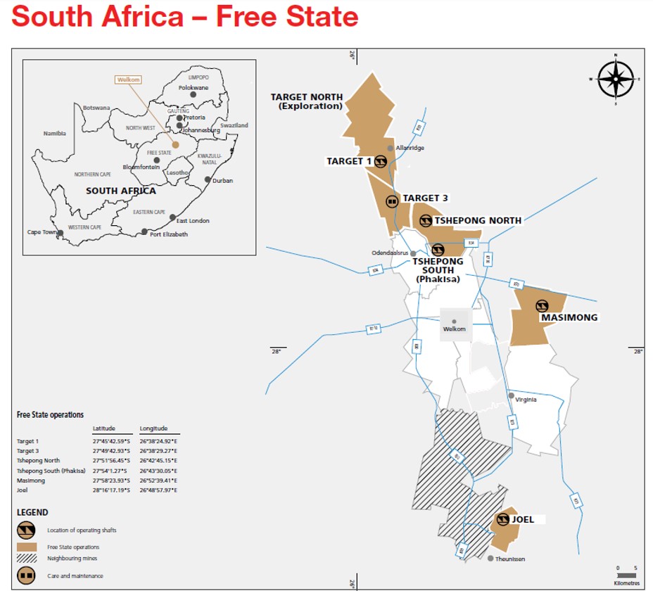
The mine is located in the Free State Province of South Africa, approximately 250km southwest of
Johannesburg and 15km to the north of the town of Welkom (Figure 3-1). Tshepong North is situated at a
latitude of 27°51’56.45”S and longitude of 26°42’45.15”E. Tshepong South (Phakisa) is situated adjacent to
the south of Tshepong North, and is located at a latitude of 27°54’1.27”S and longitude of 26°43’30.05”E.
3.1Mineral Tenure
South African Mining Law is regulated by the MPRDA which is the predominant piece of legislation dealing
with acquisitions or rights to conduct reconnaissance, prospecting and mining. There are several other pieces
of legislation which deal with such ancillary issues such as royalties (the Mineral and Petroleum Resources
Royalty Act, 2008), title registration (the Mining Titles Registration Act, 1967), and health and safety (the
Mine Health and Safety Act, 1996).
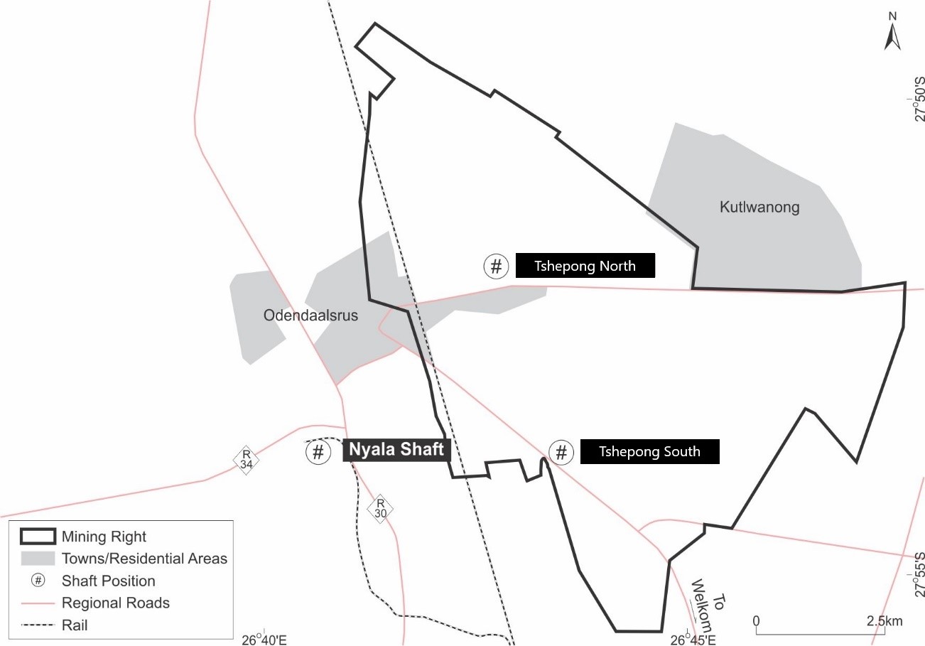
The current mining right for Tshepong North encompasses an area of 10,798.74ha (Figure 3-2). Harmony holds
several mining rights in the Free State goldfields which have been successfully converted and executed as
new order mining rights, some of which are still to be registered at the Mineral and Petroleum Resources
Titles Office (“MPRTO”). The mining right for Tshepong North is presented in Table 3-1.
Tshepong North is wholly owned by Harmony, including the associated mineral rights. Harmony commenced
acquiring the assets through the acquisition of AngloGold Ashanti Limited’s (“AngloGold Ashanti”) Free State
operations in 2001, together with ARMGold. ARMGold was subsequently incorporated into Harmony in 2003,
giving Harmony 100% ownership and control of Tshepong North.
Table 3-1: Summary of Mining Rights for Tshepong North
License Holder | License Type | Reference No. | Effective Date | Expiry Date | Area (ha) |
Freegold(Harmony) Pty Ltd | Mining Right | FS30/5/1/84MR | December 11, 2007 | December 10, 2029 | 10,799 |
There are no known legal proceedings (including violations or fines) against the Company which threatens its
mineral rights, tenure, or operations.
3.2Property Permitting Requirements
All relevant underground mining and surface permits, and any other permit related to the work conducted on
the property have been obtained and are valid.
Harmony has access to all the properties it requires to conduct its current mining activities. The surface lease
and surface right areas are sufficient in size and nature to accommodate the required surface infrastructure
to facilitate current and planned mining and processing operations.
Harmony monitors complaints and litigation against the Company as part of its risk management systems,
policies and procedures. There is no material litigation (including violations or fines) against the Company and
the QP as at the date of this report which threatens its mineral rights, tenure or operations.
Effective Date: 30 June 2026
10
Technical Report Summary for
Tshepong North, Free State Province, South Africa
Figure 3-1: Location of Tshepong North in the Free State Goldfield
Effective Date: 30 June 2026
11
Technical Report Summary for
Tshepong North, Free State Province, South Africa
Figure 3-2: Mineral Tenure for Tshepong North
Effective Date: 30 June 2026
12
Technical Report Summary for
Tshepong North, Free State Province, South Africa
4Accessibility, Climate, Local Resources, Infrastructure and Physiography
Section 229.601(b)(96)(iii)(B)(4) (i-iv)
4.1Accessibility
Access to Tshepong North is accessible via the local R70 road between Welkom and Odendaalsrus (Figure
3-1). The area has well-established rail links and an airfield within close proximity.
Entry into the mining area is restricted by security fencing, security guards, booms and lockable gates at the
main entrance. In addition, a communication system and access control system monitors personnel entering
and leaving the mine property.
4.2Physiography and Climate
The mine lease area is flat with an average height of around 1,344m above mean sea level (“amsl”). There are
no prominent topographical landmarks in the area. The topography has been affected by the presence of
slimes dams, waste rock dumps and solid waste disposal sites.
Tshepong North is situated in the Free State Goldfield, a semi-arid region with an annual rainfall of between
400mm and 600mm. Local thunderstorms and showers are responsible for most of the precipitation during
summer, from October to March, peaking in January. Hail is sometimes associated with thunderstorms.
The seasonal fluctuations in mean temperatures between the warmest and the coldest months vary between
an average minimum of 7.7°C in winter to a maximum of 37°C in summer. The month of July is generally the
coldest month with the hottest month typically being February.
Tshepong North is not restricted by climatic or seasonal variability.
4.3Local Resources and Infrastructure
The surrounding areas of Welkom and Odendaalsrus are well developed in terms of access and mining-
related infrastructure, which supports the numerous operational gold mines in the area. The regional
infrastructure includes national and provincial paved road networks, power transmission and distribution
networks, water supply networks and communication infrastructure.
The local community is in situated in close proximity of the mine which enable the work force with transport
to and from the mine. Most suppliers are locally or on site to ensure continuous operations as planned
without operational disruptions.
Tshepong North has a twin shaft system with ore and waste being hoisted to surface through the main
vertical shaft (Figure 3-2). Tshepong North ore is transported, by rail, from their respective shafts to the
Harmony One Plant in Welkom for processing (Figure 3-2). Operations are powered by electricity from Eskom
Holdings State Owned Company (“SOC”) Limited.
Effective Date: 30 June 2026
13
Technical Report Summary for
Tshepong North, Free State Province, South Africa
5History
Section 229.601(b)(96)(iii)(B)(5) (i-ii)
5.1Historical Ownership and Development
The Feasibility Study for the initial development of Tshepong North was concluded in 1984. Work to establish
the site started in September 1984 and, by 1986, shaft sinking was underway. Sinking and equipping of the
shaft were completed in 1991, with the mine being commissioned in November 1991.
The historical ownership and associated activities related to Tshepong North are summarized in Table 5-1.
Table 5-1: Summary of Historical Ownership Changes and Activities of Tshepong North
Year | Asset History Highlights |
1984 | Feasibility Study for Tshepong development section concluded. Site establishment started. |
1986 | Shaft sinking began. |
1991 | Tshepong project was commissioned. |
2001 | AngloGold announced sale of its assets in the Free State to African Rainbow Metals and Harmony Gold Mining. African Rainbow and Harmony would hold equal joint venture interests, effective January 1, 2002. |
2003 | Harmony and ARMGold merged. |
2004 | Tshepong Sub 55 Decline Project (an extension at depth of the mine from the current shaft bottom to a depth of some 2,200m) was on schedule for completion in July 2006. |
2005 | Harmony completed 62% of the decline, including 1,500m of rail construction and 700m of the conveyor system. |
2006 | The mine operated at full capacity and the Tshepong Decline Project had been completed. |
2007 | Conversion of Harmony's old order mining rights into new order mining rights in terms of the MPRDA, including that for the Tshepong North operation. |
2008 | The Tshepong Sub 66 decline project in a build-up phase, and the Sub 71 Decline project was under development. |
2017 | Tshepong and Phakisa merged into Tshepong Operations and Mineral Resource and Mineral Reserve reporting was combined. |
2022 | Tshepong Operations Mineral Resource and Mineral Reserve Reporting was separated whereby the individual operations were reported under Tshepong North and Tshepong South |
2026 | Tshepong LOM Extension Project approved extending the current LOM from 2031 to 2041 (ten years) |
5.2Historical Exploration
Strong linear B Reef value trends extending from Tshepong North Mine into Tshepong South Mine were
identified, with an expected value for the area averaging 1,291 cmg/t. A capital exploration drilling
programme was approved in August 2016 to evaluate the continuity of the B Reef mineralisation into the
Tshepong South area. Eight underground drill holes, totalling 5,180m, were completed by October 2020 at a
cost of approximately ZAR5.5 million and successfully confirmed the extension of the Tshepong North B Reef
payshoot into Tshepong South. Subsequent underground drilling further improved geological confidence in
the continuity and extent of the mineralised channel.
Exploration drilling remains ongoing. Capital funding has been approved for FY27 to execute a dedicated
underground B Reef exploration programme within the East South Upper (ESU) block. The programme
comprises five underground drilling sites, eight primary boreholes and six wedges, for a total planned drilling
campaign of 2,062m, targeting the B Reef horizons on 60, 63 and 66 Levels. The programme is designed to
improve geological confidence, define the lateral and vertical extent of the B Reef mineralisation, support the
recently approved Tshepong North Life of Mine Extension Project and identify opportunities for future
Mineral Resource growth and Mineral Reserve conversion
5.3Previous Mineral Resource and Mineral Reserve Estimates
The previous in-situ Mineral Resource estimates for Tshepong North were declared as at 30 June 2025 by
Harmony, according to the 1300 SK, 2016. The previous Mineral Resource estimates, exclusive of Mineral
Reserves, are summarized in Table 5-2 for Tshepong North. These have been superseded by the current
estimate prepared by Harmony in Section 11 of this TRS.
Effective Date: 30 June 2026
14
Technical Report Summary for
Tshepong North, Free State Province, South Africa
Table 5-2: Summary of the Previous Tshepong North Mineral Resources as at 30 June 2025 (Exclusive of Mineral
Reserves)
METRIC | |||
Mineral Resource Category | Tonnes (Mt) | Gold Grade (g/t) | Gold Content (kg) |
Measured | 12.125 | 12.40 | 150,403 |
Indicated | 6.567 | 11.43 | 75,096 |
Total / Ave. Measured + Indicated | 18.692 | 12.06 | 225,499 |
Inferred | 8.272 | 9.30 | 76,917 |
IMPERIAL | |||
Mineral Resource Category | Tons (Mst) | Gold Grade (oz/st) | Gold Content (Moz) |
Measured | 13.365 | 0.362 | 4.836 |
Indicated | 7.239 | 0.334 | 2.414 |
Total / Ave. Measured + Indicated | 20.605 | 0.352 | 7.250 |
Inferred | 9.118 | 0.271 | 2.473 |
The previous Mineral Reserve estimate for Tshepong North was declared by Harmony as at 30 June 2025 in
accordance with SAMREC, 2016. Modifying Factors were applied to the in situ Mineral Resources to arrive at
the Mineral Reserve estimate. The Mineral Reserve estimate represents the ore delivered to the mill. The
recovered gold content considers the plant recovery factor. Dilution and modifying factors are based on
historic performance.
The previous Mineral Reserve estimate is summarized in Table 5-3. These have been superseded by the
current estimate prepared by Harmony as detailed in this TRS.
Table 5-3: Summary of the Previous Tshepong North Mineral Reserves as at 30 June 2025
METRIC | |||
Mineral Reserve Category | Tonnes (Mt) | Gold Grade (g/t) | Gold Content (kg) |
Proven | 2.403 | 4.55 | 10,936 |
Probable | 1.606 | 5.85 | 9,391 |
Total / Ave. Proven + Probable | 4.009 | 5.07 | 20,327 |
IMPERIAL | |||
Mineral Reserve Category | Tons (Mst) | Gold Grade (oz/st) | Gold Content (Moz) |
Proven | 2.649 | 0.133 | 0.352 |
Probable | 1.771 | 0.170 | 0.302 |
Total / Ave. Proven + Probable | 4.420 | 0.148 | 0.654 |
5.4Past Production
The annual tonnage, grade and gold production for Tshepong North is presented in Figure 5-1 and Figure 5-2.
Effective Date: 30 June 2026
15
Technical Report Summary for
Tshepong North, Free State Province, South Africa
Figure 5-1: Graph of Past Production – Tonnes and Grade
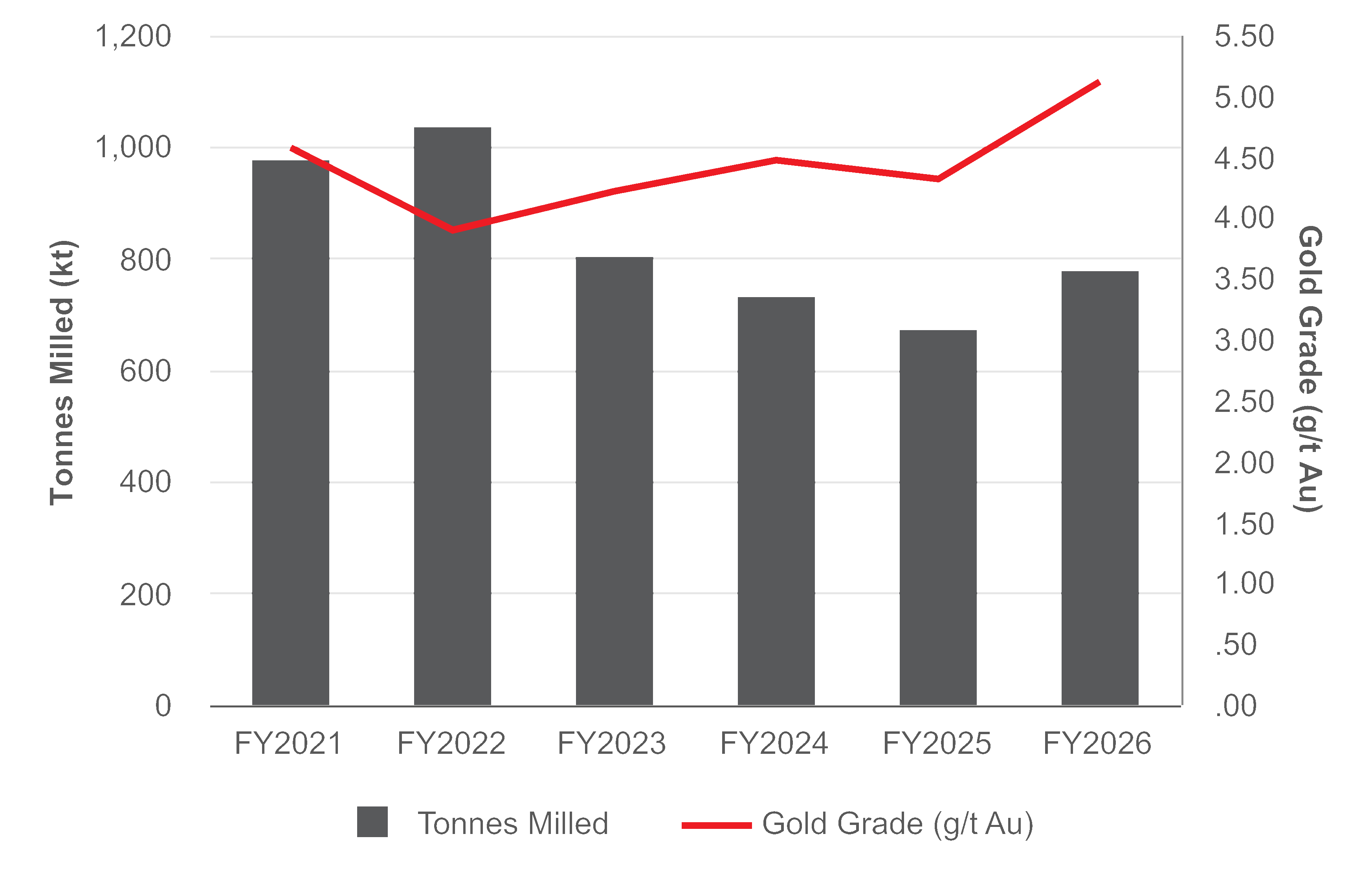
Figure 5-2: Graph of Past Metal Production
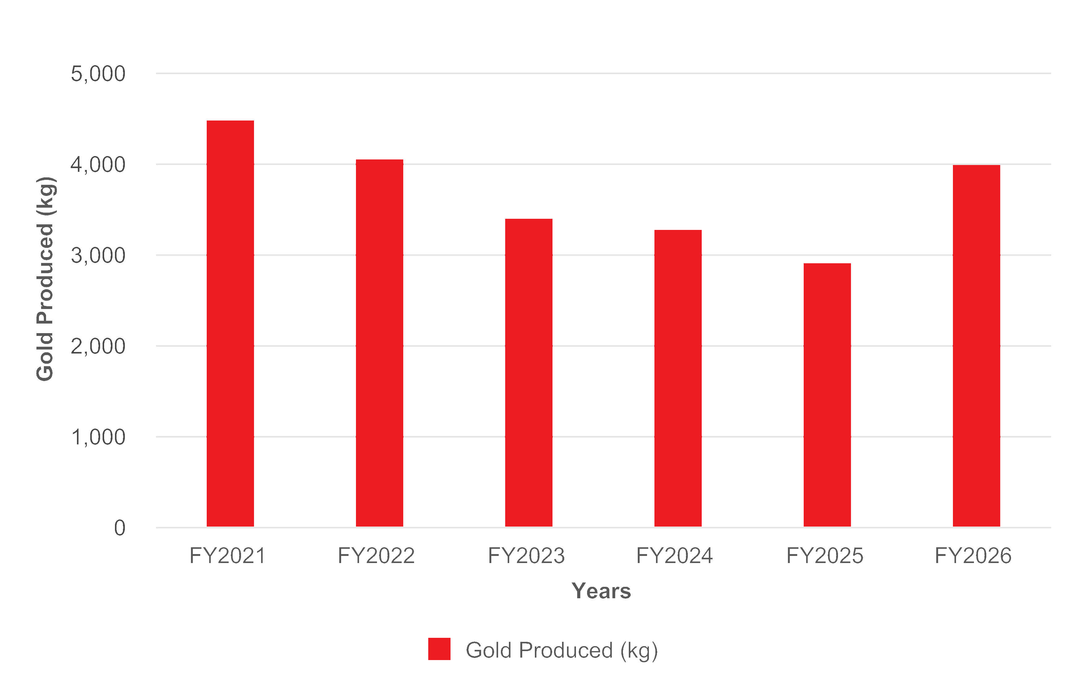
Effective Date: 30 June 2026
16
Technical Report Summary for
Tshepong North, Free State Province, South Africa
6Geological Setting, Mineralization and Deposit
Section 229.601(b)(96)(iii)(B)(6) (i-iii)
6.1Regional Geology
Tshepong North is located on the southwestern margin of the Archean Witwatersrand Basin, one of the
prominent gold provinces in the world. The Witwatersrand Basin is an approximately 7,000m thick
terrigenous sequence comprising mainly arenaceous and argillaceous, together with minor rudaceous,
lithologies deposited in a fluvio-deltaic environment in the centre of the Archaean Kaapvaal Craton of South
Africa (Robb and Meyer, 1995). The regional geology of the Witwatersrand Basin is shown in Figure 6-1.
The Witwatersrand Basin hosts the Witwatersrand Supergroup, which either conformably or unconformably
overlies the metamorphosed volcanic and minor clastic sediments of the Dominion Group (Tucker et al.,
2016). The Dominion Group overlies the older granite-greenstone basement.
The majority of the Witwatersrand Supergroup is capped by the volcano-sedimentary sequence of the
Ventersdorp Supergroup through an angular unconformity. The Ventersdorp Supergroup is in turn overlain
by the dolomitic and quarzitic sequence of the Transvaal Supergroup, and sediments of the Karoo
Supergroup (Tucker et al., 2016). Several suites of dykes and sills cut across the Archaean basement and the
Witwatersrand, Ventersdorp, Transvaal and Karoo supergroups, and form important geological time-markers.
The Witwatersrand Supergroup is sub-divided into the basal West Rand Group (“WRG”) and overlying CRG
(Robb and Robb, 1998). The WRG extends over an area of 43,000km2 and is up to 5,150m thick. It is sub-
divided in three subgroups, namely, from bottom upwards, the Hospital Hill Subgroup; Government
Subgroup and Jeppestown Subgroup. The stratigraphic succession of the WRG mainly consists of shale
sediments, with occasional units of banded iron formation and conglomerate.
The CRG is up to 2,880m thick and covers an area of up to 9,750km2, with a basal extent of c.290km x 150km.
It is sub-divided into the lower Johannesburg Subgroup and upper Turffontein Subgroup as shown in Figure
6-2. These subgroups are separated by the Booysens Shale Formation. The stratigraphic succession of the
CRG comprises coarse-grained fluvio-deltaic sedimentary rocks.
The major gold bearing conglomerates are mostly confined to the CRG, and these conglomerate horizons are
known as reefs. The most important reefs within the CRG are at six stratigraphic positions, three within the
Johannesburg Sub-group and three within the Turffontein Sub-group. The reefs are mined in seven major
goldfields, and a few smaller occurrences, which extend for over 400km in what has been called “The Golden
Arc”. This arc is centered on the prominent Vredefort Dome, as shown in Figure 6-1, which is thought to be a
major meteorite impact site in the centre of the Witwatersrand Basin (Therriault et al., 1997). The goldfields,
as shown in Figure 6-1, include: East Rand, South Rand, Central Rand, West Rand, West Wits, Klerksdorp, Free
State (Welkom), and Evander.
6.2Local Geology
Tshepong North is located within the Free State Goldfield (Figure 6-1). The stratigraphic column of the Free
State Goldfield is presented in Figure 6-2. The Johannesburg Subgroup comprises the Virginia, St Helena,
Welkom, Harmony and Dagbreek formations.
The Free State Goldfield forms a triangle between the towns of Allanridge, Welkom and Virginia. The area is
host to several gold mines, all of which produce gold from auriferous bearing reefs situated within sediments
of the Central Rand Group of the Witwatersrand Sequence (Figure 6-2). Most of the presently exploitable
reefs are situated within five stratigraphically separate placers including the Basal/Steyn, Saaiplaas Leader, B,
Kimberley and Eldorado, with the majority of tonnage derived from the Basal/ Steyn and Saaiplaas Leader.
The Witwatersrand and overlying Ventersdorp lavas were deposited in a basin with significant and continual
down warping to accommodate the sediments and lavas. During Platberg times, the basin underwent a
significant rifting and tilting event, resulting in the region being split by significant faults. These faults are
generally westerly dipping, with downthrows to the west, and strata dipping generally to the east.
Effective Date: 30 June 2026
17
Technical Report Summary for
Tshepong North, Free State Province, South Africa
Figure 6-1: Regional Geology of the Witwatersrand Basin
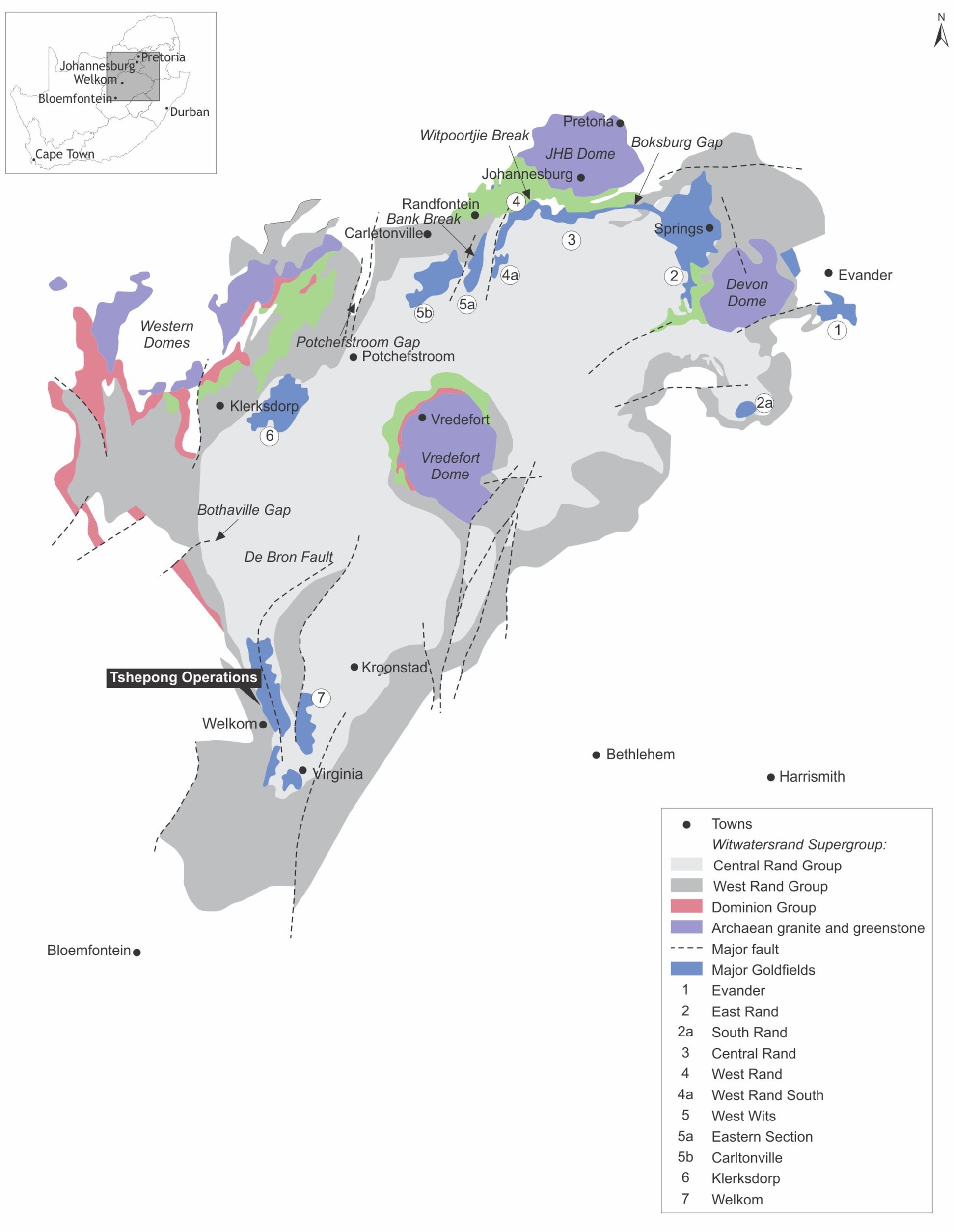
Effective Date: 30 June 2026
18
Technical Report Summary for
Tshepong North, Free State Province, South Africa
Figure 6-2: Simplified stratigraphy of the Free State Goldfield
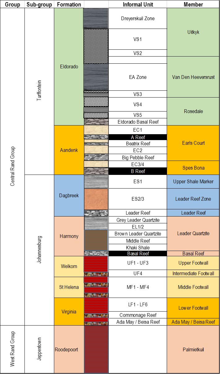
Effective Date: 30 June 2026
19
Technical Report Summary for
Tshepong North, Free State Province, South Africa
The general orientation of the Witwatersrand Supergroup succession in the Free State Goldfield is
interpreted as north-trending within a syncline that is plunging to the north (Figure 6-3). The syncline is cut
by two major faults resulting in the formation of three major fault bounded blocks:
•Odendaalsrus Section to the west of the De Bron fault;
•the Central Horst between the De Bron and Homestead faults; and
•the Virginia Section to the east of the Homestead Fault.
The Central Horst was uplifted, and the Central Rand Group rocks eroded away prior to deposition of the
Ventersdorp Supergroup and therefore comprises West Rand quartzites. The western margin of the
Tshepong North Lease is also marked by structures including the Ophir Fault that is bisected into eastern and
western portions by a second, the Dagbreek Fault.
A cross section through the fault bounded blocks is presented in Figure 6-4.
6.3Property Geology
The principal gold-bearing orebodies at Tshepong North Mine are the stratiform and strata-bound Basal Reef
(or Basal Reef Zone (“BRZ”)) (Figure 6-2) and the B Reef. The B Reef, located approximately 150m to 170m
stratigraphically above the Basal Reef, has become the dominant production horizon and currently accounts
for approximately 60% of the mine’s production volume.
6.3.1Basal Reef Lithology
The Basal Reef comprises a thin conglomerate, overlain by clean ‘placer’ quartzites. The Basal Reef is
underlain by a thick series of siliceous and argillaceous quartzites comprising the Welkom Formation and
overlain by shales and quartzites of the Harmony Formation, both of the Johannesburg Sub-group of the CRG.
The Basal Reef sits unconformably on the Welkom Formation (Figure 6-2).
The Upper Cycle Black Chert facies Basal Reef prevails in the south of the Tshepong North area and consists
of a slightly polymictic (yellow shale specks present), matrix-supported medium-pebble conglomerate with a
more gradational contact absent of carbon, where mineralization is associated with fine disseminated and
buck-shot pyrite. The conglomerate is slightly thicker compared to the Lower Cycle, but is also overlain by
barren reef quartzite, the entire package being characteristically up to only 40cm thick. The lower Khaki Shale
is up to 1m thicker.
6.3.2B Reef Lithology
The B Reef at Tshepong North occurs approximately 150m stratigraphically (or approximately two production
working levels) above the Basal Reef. Consequently, the B Reef is not normally intersected in either Basal
Reef development or routine diamond drilling.
The lowest unit is a basal lag (B1), overlying Doornkop Quartzite Formation. Where this unit is developed (or
preserved), it may be highly mineralized oligomictic or polymictic conglomerate, with visible gold, buckshot
pyrite and carbon mineralization. This unit may carry gold values of many thousands of cmg/t and represents
a potentially rewarding area for further exploration.
The unit overlying the B1 may be either B2, which comprises a mildly erosive pebbly quartzite formation,
and/or the stratigraphically younger Zone B3, which is a polymictic conglomerate with low values and is
erosional into the underlying A and B zones.
The B Reef at Tshepong South is located about 140m stratigraphically above the Basal Reef and varies in
thickness from 10cm to 170cm. The conglomerate varies in character depending on the facies, with B1 being
a small to medium pebble conglomerate and usually no more than 30cm thick with abundant carbon. The B2
facies is a small pebble lag in an argillaceous quartzite, with little to no mineralization. B3 facies is a 20 to
150cm thick conglomerate, mature, well packed, with pebble sizes varying from small to cobble size, very
polymictic, normally with abundant pyrite and some carbon. This is the most common facies.
Effective Date: 30 June 2026
20
Technical Report Summary for
Tshepong North, Free State Province, South Africa
Figure 6-3: Structural Geology of the Free State Goldfields
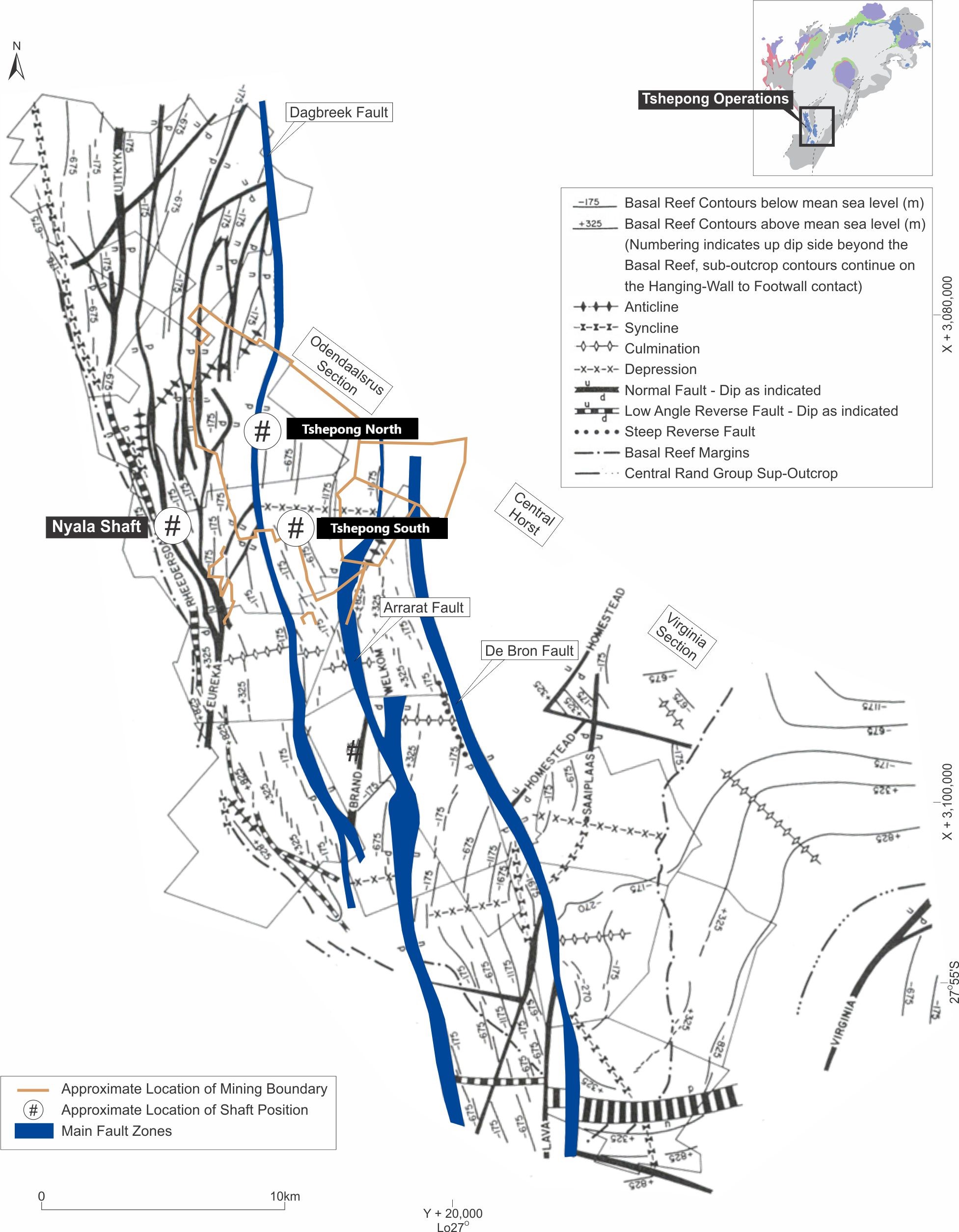
Effective Date: 30 June 2026
21
Technical Report Summary for
Tshepong North, Free State Province, South Africa
Figure 6-4: Tshepong North Cross Section
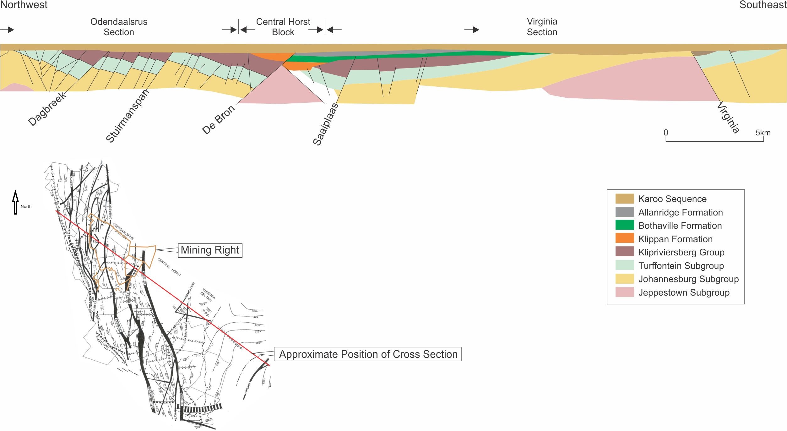
Source: Modified after Tucker et al. (2016)
Effective Date: 30 June 2026
22
Technical Report Summary for
Tshepong North, Free State Province, South Africa
6.3.3Structure
At Tshepong North, the Dagbreek Fault that strikes north-south bisects the mine into western and eastern
domains. The shaft infrastructure itself is situated largely within the zone of fault loss associated with the
Dagbreek Fault (Figure 6-3 and Figure 6-4).
The fault has a variable down throw to the west of approximately 350m, with no significant lateral
displacement. It is interpreted as an early compressional structure that has experienced later Platberg age
relaxation and subsequent extension. Reef in the eastern domain dips to the east at an average of 23° and
extends from 55 Level (1,674m depth) to 66 Level (2,010m depth), which is the lowest working level of the
Main shaft. Tshepong North has completed the Sub 71 Decline Capital Project, which extends access down
dip to 77 Level (2,350m depth), the lowest planned working level of the Sub 71 Decline Project.
Relative to the eastern domain, the western domain at Tshepong North is more structurally deformed. This is
prevalent to the north where major block rotation has occurred resulting in the reef dipping to the west. The
structural complexity of this western domain necessitates an intensive, ongoing drilling programme to locate
fault bounded reef blocks.
A second structural family of faults and dykes occurs on a NW-SE trend and are thought to be conjugate to
and thus of a similar age to the Dagbreek Fault system, but this direction of faults tends to be associated with
lateral shifts.
Many faults shown signs of lateral displacement, but the amount of this displacement is often difficult to
determine. These faults are typically oriented between N-S and NNW-SSE. Maximum displacement identified
thus far is approximately 200m on the Thelma Fault.
Yellow porphyry, acicular and quartz diorite dykes are found in the Ventersdorp suite of intrusives, while
Karoo dolerites and lamprophyres occur in the post-Ventersdorp suite of intrusives. These intrusives tend to
utilise any plane of weakness in their passage. It is therefore not unusual to find an intrusive infill along the
various fault planes and other faults within the mine area. Accompanying gouge material, showing slicken-
siding along the contacts of the intrusions, indicates that movement has taken place after these rocks were
intruded.
6.4Mineralization
The gold mineralization in the Witwatersrand deposits is believed to have followed an episode of deep burial,
fracturing and alteration. The mineralization model is that Archean gold bearing hydrothermal fluid was
introduced into the conglomerates and circulated throughout in hydrothermal cells. The fluids precipitated
gold and other elements through reactions that took place at elevated temperatures along the reef horizons,
which was the more favourable fluid conduit.
The generic mineralization model for Tshepong North Basal Reef is based on structurally controlled fluid flow
within a conglomerate hosted lithology. Fluid flow is dependent on the permeability of the host rock mass
during mineralization. Fluid flow, permeability and subsequent gold mineralization are believed to be
controlled by four key factors, including:
•Stratigraphy;
•the presence or absence of mineralization age thrust faulting;
•sedimentology; and
•precipitation agent
It is the QP's view, the sedimentological parameters are more influential and predictive for gold distribution
on a regional scale.
6.4.1Basal Reef
Within the Lower Cycle Black Chert facies, mineralization is characterized by a fine disseminated interstitial
pyrite, together with a carbon contact. Mineralization is associated with the carbon contact and
conglomerate, although some concentration is also found just below the upper reef contact. At the top of the
reef is a granular textured often gritty quartzite with fine pyrite stringers about 10cm thick.
Effective Date: 30 June 2026
23
Technical Report Summary for
Tshepong North, Free State Province, South Africa
In the Upper Cycle Black Chert Facies, mineralization is associated with the carbon contact and conglomerate,
although some concentration is also found just below the upper reef contact. It does not have such a well-
developed carbon contact as the Lower Cycle facies and is often of lower grade.
6.4.2B Reef
The B1 facies has abundant carbon and gold as associated with the carbon. The B2 facies has little to no gold
mineralization, while the B3 facies normally has abundant pyrite and some carbon. Free gold is found in
association with the flyspeck carbon.
6.4.3Alteration
Alteration is evident in the Basal Reef and B Reef at Tshepong North and is a result of the hydrothermal fluids
that infiltrated the reef and have overprinted on the original mineral assemblage. The reefs contain
authigenic sulphides such as pyrite, and other minerals associated with alteration such as chlorite. Gold
associations with these mineral assemblages indicate a strong correlation of gold mobilisation and
redistribution at the time of the hydrothermal fluid influx.
While alteration is an important part of the mineralization, alteration is not used for the identification,
modelling or mining of the reefs.
6.5Deposit Type
Tshepong North deposit is classed a meta-sedimentary gold deposit. Folding and basin edge faulting have
been important controls for sediment deposition and gold distribution patterns within the Witwatersrand
Basin and fold trends have been employed in the economic evaluation of various reef horizons.
6.6Commentary on Geological Setting, Mineralization and Deposit
The regional geological setting, local and property geology, mineralization and deposit-type for Tshepong
North is well established, through many decades of exploration and mining. Reliable geological models, maps
and cross sections are available that support the interpretations and inform the Mineral Resource estimates.
Effective Date: 30 June 2026
24
Technical Report Summary for
Tshepong North, Free State Province, South Africa
7Exploration
Section 229.601(b)(96)(iii)(B)(7) (i-vi)
Geological data has been obtained through initial surface drilling, followed by underground drilling, mapping
and channel (chip) sampling.
Exploration from underground platforms is currently continuing for Tshepong North sub-75 development and
B Reef ESU block, to improve geological confidence.
Tshepong North and South operations are continuously undergoing B Reef exploration drilling to identify any
potential continuation of the current pay shoots connecting these mines.
7.1Geophysical Surveys
Initial exploration included a historical geophysical seismic survey to obtain information of subsurface rock
formations and geological structures using shock wave reflections and surface diamond core drilling. The
current Mineral Resource model is no longer informed by the geophysical seismic survey and the model relies
only on borehole information and underground mapping information.
7.2Topographic Surveys
As an underground operation, topographic surveys are not material to the Mineral Resource estimates.
7.3Underground Mapping
Face and reef development mapping is undertaken by a team comprising a Sampler or Geologist, and an
assistant. Face tapes are setup along gullies and the stope face and secured with reference to the latest
survey pegs installed in the workplaces. Reef position and other lithological and stratigraphic information is
collected and measured relative to the reference tapes. The information is captured in a notebook.
Once at surface, the person responsible transfers the information from the notebook into DeswikTM, where a
mapping report is produced for each mapped workplace. The mapping reports depict the geological
information graphically relative to the survey measurement points. Data from the mapping is also
incorporated into the geological models.
Approximately 80-90% of all workplaces are inspected by member of the Geosciences team monthly to
ensure that suitable mapping information coverage is achieved.
7.4Channel Sampling Methods and Sample Quality
Channel sampling of underground panels are carried out on monthly basis. Sampling is conducted
perpendicular to the channel contact across the exposed channels. The section lines demarcating the width
of the sample are drawn parallel to the reef waste contact while those demarcating the length of the sample
are drawn at right angles to the reef waste contact and are marked 10cm apart. The samples are chipped out
between these section lines.
The sampler ensures that the face is clean and free of any contamination during chipping and avoids spillage
while bagging the underground chip samples to ensure integrity.
Sampling of the Basal Reef and B Reef stoping channels are undertaken at the advancing face on a grid
spacing of 5m x 5m. The sampling process is audited monthly and annually by the Geoscience Manager.
Development sampling is on 2m intervals for Basal reef and B Reef. The results are captured into the
information system and plotted on a development sampling sheet.
Sample integrity is maintained through a controlled chain-of-custody process. Upon arrival on surface,
samples are deposited into a secure steel chute feeding directly into a locked sample bin within the shaft
area, preventing unauthorized removal. The Sample Crew Supervisor unlocks the bin, performs a physical
sample count, and reconciles the total against the Assay Analysis Forms.
Following verification, a waybill is prepared and the samples are transported to the assay laboratory in a
locked sample box under the supervision of the Sample Crew Supervisor. Upon receipt at the laboratory, the
sample box is opened in the presence of authorized laboratory personnel, the samples are counted and
Effective Date: 30 June 2026
25
Technical Report Summary for
Tshepong North, Free State Province, South Africa
reconciled against the dispatch records, and the Laboratory Supervisor signs the Assay Analysis Form to
confirm receipt. This process ensures sample security, traceability, and accountability from collection through
to laboratory submission.
The location of sample sections collected from the Basal and B Reef, to date, are shown in Figure 7-1 and
Figure 7-2. A total of 863 gold sample sections on average are taken monthly, 432 Basal Reef and 431 B Reef.
7.5Surface Drilling Campaigns, Procedures, Sampling, Recoveries and Results
Most surface drill holes used in the estimation of the current Mineral Resources were drilled by AngloGold
Ashanti, or its forebears, before Harmony acquired Tshepong North.
Effective Date: 30 June 2026
26
Technical Report Summary for
Tshepong North, Free State Province, South Africa
Figure 7-1: Location of Channel Samples Collected from the Basal Reef
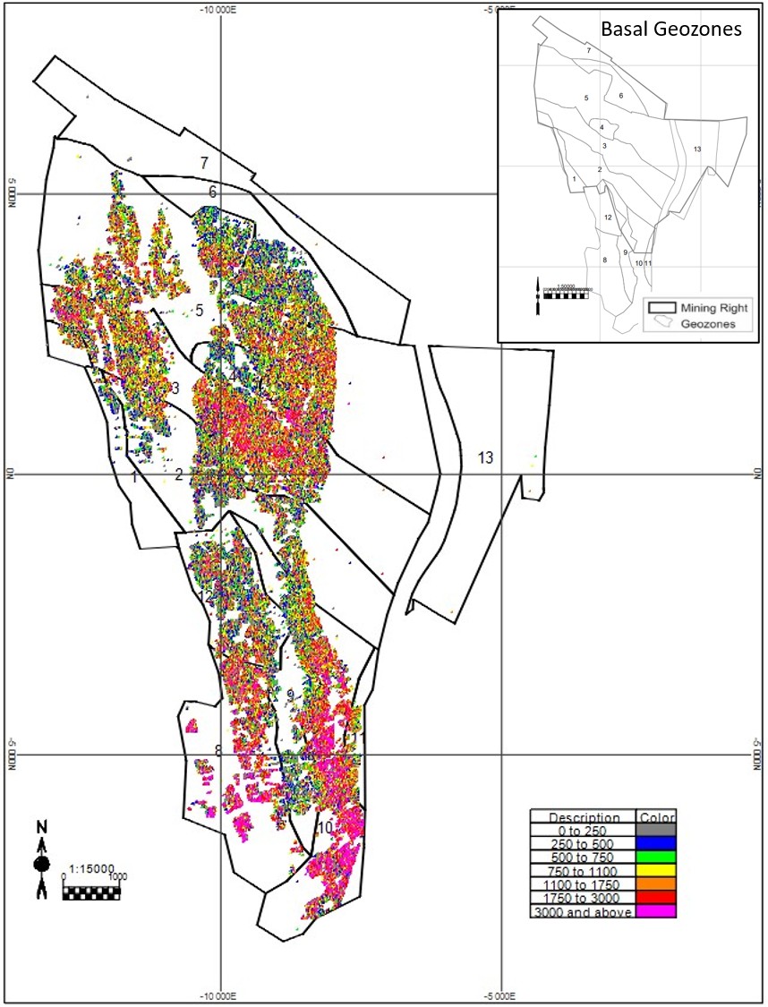
Effective Date: 30 June 2026
27
Technical Report Summary for
Tshepong North, Free State Province, South Africa
Figure 7-2: Location of Channel Samples Collected from the B Reef
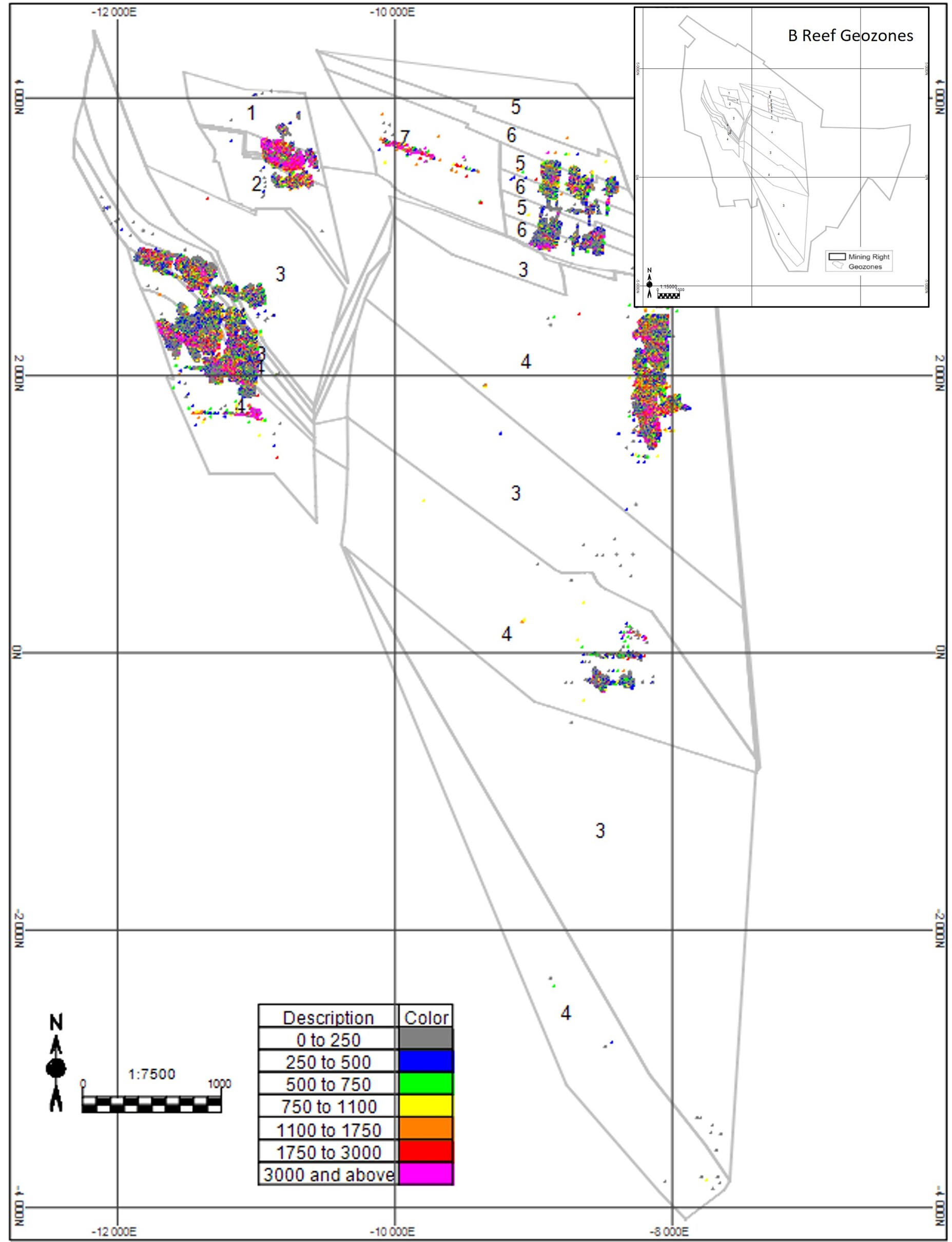
7.5.1Drilling Methods
The surface diamond core drilling has been undertaken using a thin-walled core barrel (AXT size core barrel)
that delivers 35.51mm core. A single mother hole is drilled, typically with deflection holes drilled from it.
The drill grid spacing of the surface drill hole intersections is up to 100m and is often required to be
complemented by underground drill hole intersections. The accuracy of the surface drilling intersection
positions from drill holes that are from 2,000m to 3,000m in depth is the major limiting factor of achieving
the planned grid. Long surface drill holes often deflect and controlling direction over that depth has always
been challenging in the South African gold mining context.
Effective Date: 30 June 2026
28
Technical Report Summary for
Tshepong North, Free State Province, South Africa
7.5.2Collar and Downhole Surveys
The drill holes are surveyed to confirm both collar position and trajectory. Drill hole collar and downhole
surveys are conducted on all surface drill holes.
Surface drill hole collars are surveyed by internal Land Survey Department. Underground drill hole collars are
checked against layouts issued to diamond drilling.
Downhole surveying is conducted using non-magnetic north seeking Gyro tools as supplied by a certified and
specialised downhole survey company, Digital Surveying (Pty) Limited. The instrument is a magnetic based
tool and as such all readings are relevant to magnetic north. The survey data is collected with an in-run and
out-run per borehole. The dip and azimuth difference must be within 0.5° and 1.5° on the in-run and out-run
respectively.
7.5.3Logging Procedures
Upon arrival at the core yard located on-site, drill core is marked at every meter interval. The core is then
orientated so that the low point of bedding is coincident with the edge of the angle iron. The cut line is
defined by the low point of the bedding at the base of the reef zone, when viewed as per convention, from
left to right in the direction of increasing depth, is drawn parallel to the core. The core is then rotated
through 90° and a yellow line was then drawn parallel to the core, to define the retention half core.
All drill cores are photographed prior to logging and sampling. The geologist conducts the core logging.
Drill core logging is quantitative and qualitative. The following information is recorded:
•lithology;
•packing density;
•roundness;
•sorting;
•contact type, grain/pebble size;
•sediment maturity; and
•mineralization; and alteration.
The geologist responsible for logging the core stores the original paper record. Core logging is also stored
electronically using Datamine Fusion software. Internal peer reviewing is undertaken on the interpretation of
the stratigraphy and spatial correlation of drill holes.
Observations are captured on the diamond drilling database by geologists. The logs are checked by the Senior
Geologist prior to sampling. Logging procedures are conducted as per the Harmony company standards,
which are used on all underground mines and are best practice and have been in place since 2001.
7.5.4Drilling Results
The location of the surface and underground drill holes intersecting the Basal and B Reefs are presented in
Figure 7-3 and Figure 7-4. There are no recent surface drilling results (Table 7-1), all surface drilling dates
back to previous project owners and is pre-2017. All acceptable and representative reef intersection assay
results have been included into the geological modelling and Mineral Resource estimation process. These
drill holes were drilled to a depth of 2,373m below the surface.
Effective Date: 30 June 2026
29
Technical Report Summary for
Tshepong North, Free State Province, South Africa
Figure 7-3: Location of Surface and Underground Drill Holes on the Basal Reef
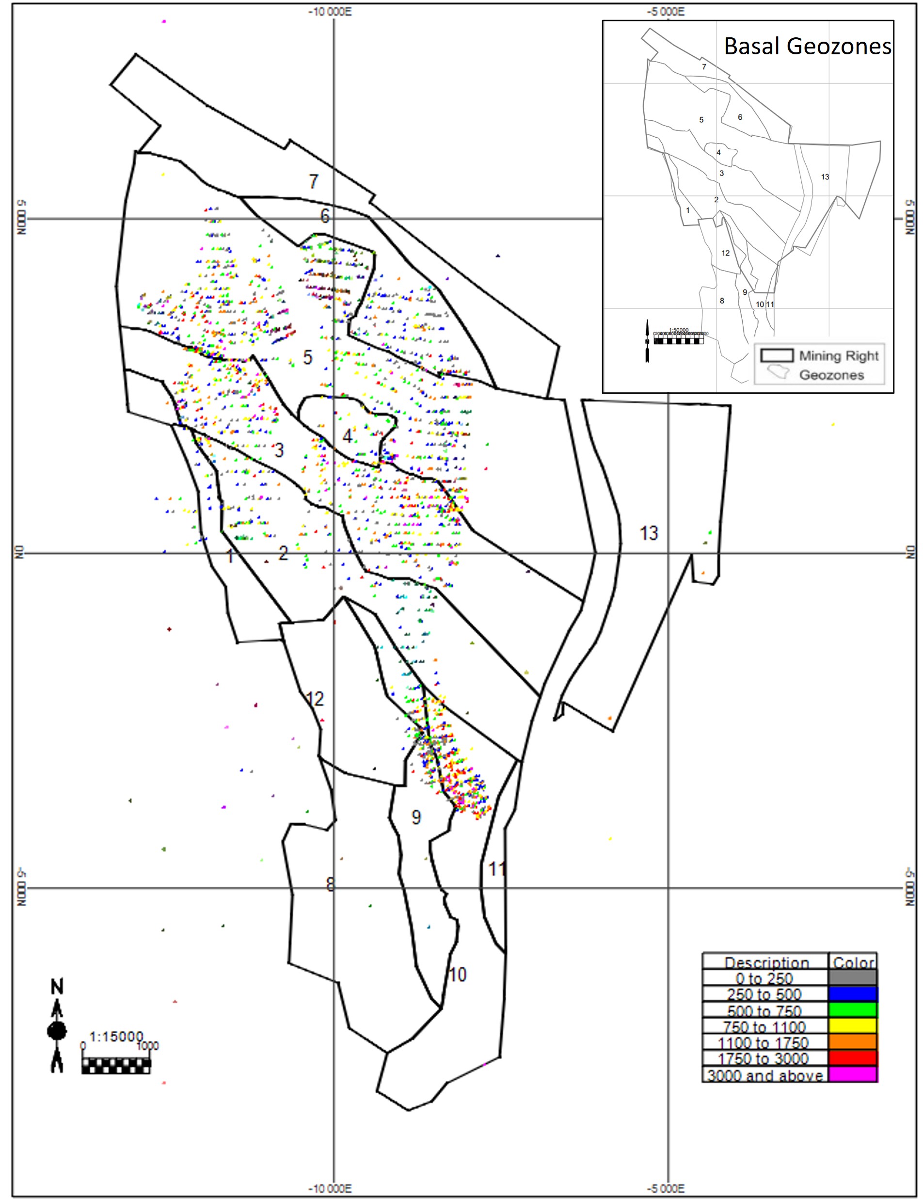
Effective Date: 30 June 2026
30
Technical Report Summary for
Tshepong North, Free State Province, South Africa
Figure 7-4: Location of Surface and Underground Drill Holes on the B Reef
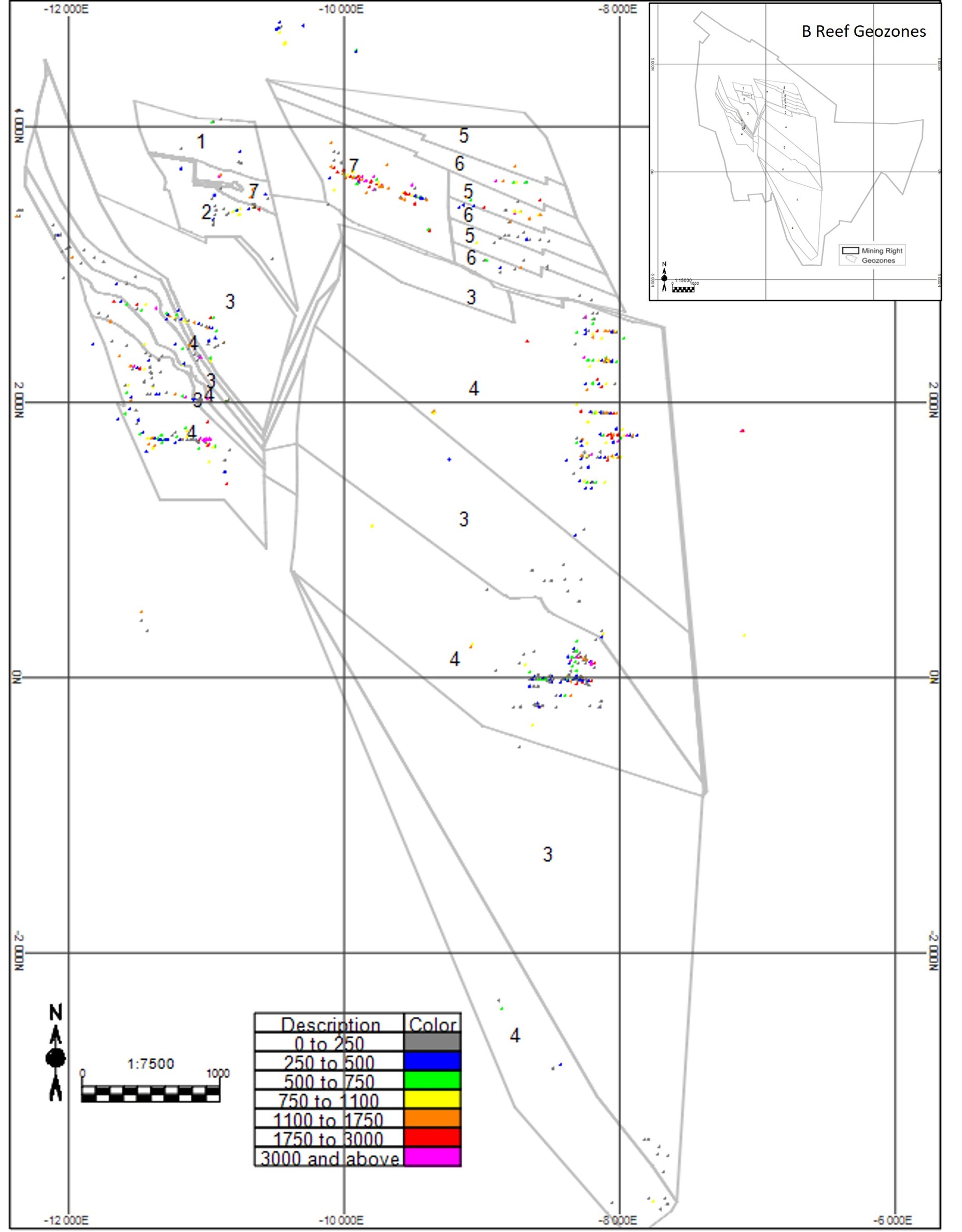
Effective Date: 30 June 2026
31
Technical Report Summary for
Tshepong North, Free State Province, South Africa
Table 7-1: Summary of Surface and Underground Drilling for Tshepong North
Year | Company | No. Drill Holes | Surface (m) | Underground (m) |
2018 | Harmony | 150 | — | 17,794 |
2019 | Harmony | 141 | — | 16,745 |
2020 | Harmony | 149 | — | 17,656 |
2021 | Harmony | 158 | — | 18,669 |
2022 | Harmony | 198 | — | 21,978 |
2023 | Harmony | 230 | — | 12,633 |
2024 | Harmony | 194 | — | 11,478 |
2025 | Harmony | 96 | — | 11,060 |
Total | 1,316 | — | 128,013 | |
7.5.5Core Recovery
Upon delivery to the core yard, and prior to logging and sampling, the drill core is checked to ensure 100%
core recovery. Core recovery is determined by dividing the measured length of the recovered core by the
total length of the core run.
An intersection is complete and representative if core recovery is greater than 99%. Drill holes with poor
recovery are not sampled. Extra caution is taken during the drilling process to ensure maximum core recovery
on reef intersections, to prevent sample bias.
Reef intersection “acceptability” is categorised as per the criteria summarized in Table 7-2 and is determined
by geologists based on, amongst others, drill core condition and faulting. The acceptability is verified for each
reef intersection before the assay results are used for Mineral Resource estimation.
All surface boreholes incorporated into the Mineral Resource model had 95% recovery over the coring
portion. Only acceptable reef intersections were used for Mineral Resource estimates.
Table 7-2: Drill hole Acceptance Criteria
Category | Comment |
Acceptable | 100% core recovery in the reef zone, or very minor loss due to reef chipping. No evidence of faulting within the reef horizon or at either contact with hanging wall or footwall lithologies. |
Minimum value | Light to moderate disking of core in the core barrel due to drilling and/or ground conditions. Visual observations indicate that the conglomerate portion of the reef is usually more prone to disking, resulting in possible gold loss. |
Faulted minimum value | If the fault loss is considered to be minor, this term may be used if the geologist is certain that only low-value internal quartzite is missing from the intersection. |
Not acceptable | Heavy disking of core which may indicate core loss, partial known core loss due to grinding. Also faulting of any description within the reef zone. |
7.5.6Sample Length and True Thickness
Mineralization of the reefs is perpendicular to or at an angle to the drill holes. As such, all drill hole reef
intersection widths are corrected to true thickness for gold value calculation.
7.6Underground Drilling Campaigns, Procedures and Sampling
Underground exploration drilling has been ongoing throughout the operational life of Tshepong North as the
mine deepens. Most of the underground drill holes used in the estimation of the current Mineral Resources
were drilled by AngloGold Ashanti before Harmony acquired the mine.
7.6.1Drilling Methods
Underground diamond core drilling is conducted using hydraulically driven and pneumatic reverse circulation
drill rigs, which typically delivers an AXT size core (35.51mm). These are short drill holes rarely exceeding
200m in length.
Fans of drill holes are drilled from diamond drilling bays, which are developed at 50m intervals along footwall
development cross cuts and 100m intervals along haulages and return airways. The drilling fans consist of up
Effective Date: 30 June 2026
32
Technical Report Summary for
Tshepong North, Free State Province, South Africa
to ten individual drill holes at inclinations ranging from -15° to +30° of vertical, or as dictated by local
geological structures.
7.6.2Collar and Downhole Surveys
The drill holes used for reef delineation at Tshepong North are surveyed on recommendation of the
geologist. In general drill holes at depth >120m and at an angle less than 20 degrees are surveyed with a
98%accuracy (these drill holes are drilled very seldom). Surveys are done to confirm both collar position and
trajectory. Drill hole collar and downhole surveys are conducted on long inclined borehole (“LIBs”) or long
vertical boreholes (“LVBs”), as well as on most of the groundwater boreholes (“GBH”) and dewatering
boreholes (“DBH”) drilled on the mine.
Surveying of exploration drill holes at Tshepong North is outsourced to Digital Surveying (Pty) Limited.
Downhole surveys are conducted on all LIB/LVB drill holes using non-magnetic north-seeking Gyro tools to
verify drill hole trajectories. Survey data are quality checked, captured in Fusion Datamine™ and transferred
to the Datamine™ database. Gyro surveys are referenced to true north and are collected using both an in-run
and out-run for each borehole. The dip and azimuth differences between the in-run and out-run surveys are
required to be within 0.5° and 1.5°, respectively.
All records received from the survey company are checked for quality and then captured and stored in the
electronic databases.
7.6.3Logging Procedures
Upon arrival at the core yard located on-site, drill core is marked at every meter interval. The core is then
orientated so that the low point of bedding is coincident with the edge of the angle iron. The cut line is
defined by the low point of the bedding at the base of the reef zone, when viewed as per convention, from
left to right in the direction of increasing depth, is drawn parallel to the core. The core is then rotated
through 90° and a yellow line was then drawn parallel to the core, to define the retention half core.
All drill cores are photographed prior to logging and sampling. The geologist conducts the core logging.
Drill core logging is quantitative and qualitative. The following information is recorded:
•lithology;
•packing density;
•roundness;
•sorting;
•contact type, grain/pebble size;
•sediment maturity; and
•mineralization; and alteration.
The geologist responsible for logging the core stores the original paper record. Core logging is also stored
electronically using both DeswikTM and Fusion DatamineTM software. Internal peer reviewing is undertaken
on the interpretation of the stratigraphy and spatial correlation of drill holes.
Observations are captured on the diamond drilling database by geologists. The logs are checked by the Senior
Geologist prior to sampling. Logging procedures are conducted as per the Harmony company standards,
which are used on all underground mines and are best practice and have been in place since 2001.
7.6.4Drilling Results
In 2025, ending December, a total of 81 underground boreholes were drilled. Of these, 19 were on the Basal
Reef, with an average channel width of 22 cm and an average grade of 742 cmg/t. Additionally, 62 boreholes
were drilled on the B Reef, with an average channel width of 174 cm and an average grade of 891 cmg/t.
Tables 7-3 and 7-4 present a summary of the 2025 underground drilling results for the Basal Reef and B Reef
at Tshepong North, which were used in the Life of Mine estimation model.
7.6.5Core Recovery
Effective Date: 30 June 2026
33
Technical Report Summary for
Tshepong North, Free State Province, South Africa
Upon delivery to the core yard, and prior to logging and sampling, the drill core is checked to ensure 100%
core recovery. Core recovery is determined by dividing the measured length of the recovered core by the
total length of the core run.
A reef intersection is complete and representative if core recovery is greater than 99%. Drill holes with poor
recovery are not sampled. Extra caution is taken during the drilling process to ensure maximum core recovery
on reef intersections, to prevent sample bias.
Reef intersection “acceptability” is categorised as per the criteria summarized in Table 7-2 and is determined
by geologists based on, amongst others, drill core condition and faulting. The acceptability is verified for each
reef intersection before the assay results are used for Mineral Resource estimation.
All surface boreholes incorporated into the Mineral Resource model had 95% recovery over the coring
portion. Only acceptable reef intersections were used for Mineral Resource estimates.
7.6.6Sample Length and True Thickness
In areas where drill holes intersect the orebodies at obtuse angles, the sampled width is corrected for true
thickness using the angle of intersection and the drilled width. The true thickness is used to determine the
value the gold content of the reef.
7.7Hydrogeology
Tshepong North has a good understanding of the local geology and geohydrology through numerous
geohydrological and mass transport models done over the years.
Tshepong North mine is characterized by two aquifers:
•A Shallow Weathered and Fractured Karoo Aquifer (Karoo Formations): A shallow, weathered aquifer
exists in the weathered shale and sandstone at an average depth of 10m – 20m below ground level.
The most consistent water strike is located at the fresh bedrock / weathering interface.
◦The primary porosity of the Vryheid Formation is very low. Any water bearing capacity is therefore
associated with secondary joints, bedding planes and faults. The contact zones of dolerite intrusions
are considered the primary source of groundwater flow within the deeper formations.
◦The two aquifers may or may not be hydraulically connected, dependent on the local geology.
•A Deep Witwatersrand/Ventersdorp Aquifer: The deep brine Witwatersrand aquifer is situated
approximately 300m below surface. This aquifer is thought to be connate (i.e. original formation
water) or extremely old (fossil) water and is usually concentrated on geological structures such as fault
zones or igneous intrusions (e.g. dykes).
The major fractures that formed during the Ventersdorp tectonic events were filled with water to a depth of
several kilometres. The impermeable nature of the overlying Karoo sediments, particularly the Dwyka
Formation at the base of the Karoo, effectively sealed off the aquifer (Van Biljon, 1995). Post-Karoo
movement and intrusions provided conduits for leakage from the Karoo aquifers to the deep Witwatersrand
aquifer. However, the deep aquifer recharge from surface is regarded as negligible and at best localized (Van
Biljon, 1995).
This is concluded based on the dewatering of this aquifer over the past 40 years during which the water
levels in the Witwatersrand aquifer dropped significantly. Underground dewatering boreholes have dried up
in some instances (Van Biljon, 1995).
Previous studies concluded the following:
•There is no or very limited hydraulic connectivity between the Karoo aquifers and the deeper
Witwatersrand aquifer.
•Recharge to the Witwatersrand aquifer is negligible.
•Once the Witwatersrand aquifer is dewatered (or the water level lowered) it will not recover. The
estimated post-mining water level in the Witwatersrand aquifer will therefore be deeper than the pre-
mining water level of ~200m below surface.
Effective Date: 30 June 2026
34
Technical Report Summary for
Tshepong North, Free State Province, South Africa
7.8Geotechnical Data
Geological exploration drilling is generally not designed to obtain geotechnical information. Geotechnical
data are collected independently by the Geotechnical Engineer using appropriate geotechnical investigation
methods. Geotechnical issues related to underground workings are discussed in more detail in the Mining
and Mine Design sections (Section 13).
Numerical modelling is done using rock mass characteristics from geological core samples, to determine the
rock wall condition factor and average pillar stress. A point load test machine is used to conduct point load
tests of random rock samples, correlating it with core testing results. Applying the geotechnical properties
obtained improves back analysis of seismic events and building a more comprehensive geotechnical model of
the mine. Quality assurance is enhanced by using expert external service providers where applicable.
A seismic network is utilized at Tshepong North to monitor seismicity which consist out of 25 component
geophones which are installed across the mine and 2 regional seismic sites is also installed. The digital seismic data is
transmitted from the seismic underground stations to the surface seismic server (RTS) via the mines Hirschman
switches and through ADSL, the Ethernet (LAN) based infrastructure available on the mine. Automatic as well
as Manual processing of the recorded seismic data is done by the Institute of Mine Seismology. On Harmony
the objective of seismic monitoring is to prevent seismicity. The seismic network is planned to a horizontal
accuracy within 25 to 50m with a network sensitivity of (Mmin) – 0.0 to 0.5. The seismic monitoring system is
designed to provide information to the rock engineering practitioner and production officials on a daily and
monthly basis. Daily, seismic plots are produced to indicate the existence of “high seismic deformation”
areas.
Table 7-3: Summary of Recent Tshepong North Underground Drill Holes Intersecting the Basal Reef
Year | Drill Hole ID | Gold Value (cmg/t) | Ave. Channel Width (cm) |
2025 | GBH 9183 | 737 | 23 |
2025 | GBH 9196 | 180 | 17 |
2025 | GBH 9199 | 174 | 21 |
2025 | GBH 9201 | 559 | 16 |
2025 | GBH 9202 | 342 | 17 |
2025 | GBH 9225 | 629 | 25 |
2025 | GBH 9231 | 486 | 25 |
2025 | GBH 9236 | 216 | 15 |
2025 | GBH 9247 | 1,976 | 23 |
2025 | GBH 9249 | 766 | 25 |
2025 | GBH 9250 | 535 | 21 |
2025 | GBH 9253 | 689 | 16 |
2025 | GBH 9256 | 81 | 25 |
2025 | PBH 49 | 3,496 | 19 |
2025 | PBH 53 | 1,079 | 18 |
2025 | PBH 57 | 1,117 | 25 |
2025 | PBH 58 | 223 | 24 |
2025 | PBH 59 | 343 | 48 |
2025 | PBH 60 | 461 | 23 |
Effective Date: 30 June 2026
35
Technical Report Summary for
Tshepong North, Free State Province, South Africa
Table 7-4: Summary of Recent Tshepong North Underground Drill Holes Intersecting the B Reef
Year | Drill Hole ID | Gold Value (cmg/t) | Ave. Channel Width (cm) | Year | Drill Hole ID | Gold Value (cmg/t) | Ave. Channel Width (cm) | |
2025 | GBH 9126 | 1723 | 174 | 2025 | GBH 9277 | 1405.9 | 195.1 | |
2025 | GBH 9128 | 953 | 285 | 2025 | GBH 9278 | 1619.5 | 169 | |
2025 | GBH 9131 | 403 | 116 | 2025 | GBH 9279 | 759.3 | 312.4 | |
2025 | GBH 9137 | 243 | 64 | 2025 | GBH 9284 | 30.4 | 45.1 | |
2025 | GBH 9176 | 117 | 58 | 2025 | GBH 9286 | 1487.4 | 596.7 | |
2025 | GBH 9184 | 187 | 113 | 2025 | GBH 9287 | 427.2 | 171 | |
2025 | GBH 9191 | 40 | 67 | 2025 | GBH 9288 | 482.7 | 209.9 | |
2025 | GBH 9192 | 45 | 100 | 2025 | GBH 9289 | 1039.3 | 460.4 | |
2025 | GBH 9194 | 439 | 217 | 2025 | GBH 9291 | 832.1 | 136.1 | |
2025 | GBH 9195 | 505 | 249 | 2025 | GBH 9293 | 517.8 | 283.8 | |
2025 | GBH 9197 | 331 | 139 | 2025 | GBH 9294 | 1710.5 | 410.6 | |
2025 | GBH 9198 | 34 | 68 | 2025 | GBH 9294 | 1710.5 | 410.6 | |
2025 | GBH 9203 | 1047 | 110 | 2025 | GBH 9295 | 2353.7 | 165.4 | |
2025 | GBH 9204 | 84 | 177 | 2025 | GBH 9296 | 2180.1 | 251.7 | |
2025 | GBH 9211 | 182 | 38 | 2025 | GBH 9297 | 257.6 | 126 | |
2025 | GBH 9215 | 203 | 227 | 2025 | GBH 9299 | 163.4 | 134.8 | |
2025 | GBH 9216 | 380 | 162 | 2025 | GBH 9300 | 722.7 | 87.3 | |
2025 | GBH 9217 | 52 | 72 | 2025 | GBH 9301 | 434.4 | 284 | |
2025 | GBH 9218 | 116 | 83 | 2025 | GBH 9304 | 420.8 | 69.4 | |
2025 | GBH 9223 | 8472 | 77 | 2025 | GBH 9305 | 376.3 | 365.5 | |
2025 | GBH 9227 | 2194 | 136 | 2025 | GBH 9307 | 41.9 | 65.1 | |
2025 | GBH 9229 | 146 | 108 | 2025 | GBH 9308 | 454.5 | 294.6 | |
2025 | GBH 9237 | 1451 | 159 | |||||
2025 | GBH 9240 | 2618 | 95 | |||||
2025 | GBH 9241 | 882 | 130 | |||||
2025 | GBH 9244 | 426 | 117 | |||||
2025 | GBH 9245 | 1105 | 97 | |||||
2025 | GBH 9248 | 2949 | 91 | |||||
2025 | GBH 9251 | 1219 | 147 | |||||
2025 | GBH 9255 | 192 | 168 | |||||
2025 | GBH 9258 | 40 | 67 | |||||
2025 | GBH 9259 | 814 | 123 | |||||
2025 | GBH 9265 | 571.8 | 212.1 | |||||
2025 | GBH 9266 | 398.4 | 290.5 | |||||
2025 | GBH 9267 | 915.1 | 163.1 | |||||
2025 | GBH 9271 | 670.2 | 155 | |||||
2025 | GBH 9272 | 1057.5 | 189.1 | |||||
2025 | GBH 9273 | 469.7 | 215.7 | |||||
2025 | GBH 9274 | 33.1 | 118.2 | |||||
2025 | GBH 9276 | 2091.4 | 195.5 |
7.9Commentary on Exploration
Surface drilling was used as the initial exploration drilling, and this was later infilled to provide sufficient
detail for geological modelling and Mineral Resource estimation. The underground infill drilling system is in
place to improve data density in specific areas and are drilled from the underground development access
drives.
Logging procedures are conducted as per the Harmony company standards, which are used on all surface and
underground mines and are best practice and have been in place consistently since 2001. Previously
extensive drilling together with 3D seismic surveys was done and the Tshepong North geology and
depositional environment is relatively well understood. All information is safely stored at the Harmony Steyn
offices.
The QP is of the opinion that the quality and quantity of the exploration methods and information gathered is
sufficient to support the estimation of Mineral Resources and Mineral Reserves.
Effective Date: 30 June 2026
36
Technical Report Summary for
Tshepong North, Free State Province, South Africa
8Sample Preparation, Analyses and Security
Section 229.601(b)(96)(iii)(B)(8) (i-v)
This section summarizes information relating to the sample preparation on site through to the laboratory
preparation and analysis.
8.1Sampling Method and Approach
Sample types used to support both production and geological exploration include diamond drill core samples
and channel (chip) samples.
8.1.1Channel Samples
Channel sampling is (and was by Anglo previously) undertaken according to industry best practice, and
presently now according to Harmony’s Underground Sampling Procedure which incorporates QA/QC
principles. Tshepong North sampling grid on the Basal Reef and B Reef stoping is a 5m by 5m interval grid.
For development, Basal Reef and B Reef are sampled at 2 m intervals; the full extent of the on-reef
development must be sampled on one sidewall.
Samples are chipped from the advancing face from within clearly measured and marked channel sections,
including the 2cm hanging wall and footwall width. Sample widths are measured at right angles to the dip of
the reef. Individual sample widths are measured from bottom to top along the two parallel lines. Two clino-
rules are used for measuring the sample widths. One ruler is held horizontally with the spirit level on strike,
and another held at right angles to the dip. The two rulers must cross each other at right angles. The face
measured must agree with the totals of all individual widths. All measurements are made to the nearest
centimetre.
The channel and sample lines are chipped out using a standard chisel and mallet, bagged, labelled with a
unique sampling number, and sealed. An adequate mass of each sample is collected to allow sufficient sized
aliquots to be analysed at the designated laboratory. The minimum sample weight sent for assay is
approximately 300g.
Samples are weighed and submitted to the designated laboratory for analyses. All inter-person transfers are
recorded. This process continues until the samples have been submitted to the laboratory.
From 2003, a total of 313 466 samples from the Basal Reef and B Reef were taken. The results indicated various
geological information regarding facies, depositional environment and grades which is useful in identifying
and delineating areas of economic interest. The results have, however, been included into the geological
modelling and Mineral Resource estimation process.
8.1.2Core Samples
Diamond drill core is transported to the on-site storage facility under the supervision of a Senior Geologist.
Upon arrival, the core is logged and sampled according to the internal Harmony Drill hole Sampling
Procedure.
Where possible the entire channel width intersected in each drill hole is split using a diamond drill core cutter
and one half of the sample is bagged, tagged and sent to the designated laboratory for assay. The remaining
half is retained for future reference. If the core condition or size is such that a successful cut cannot be
achieved, then the whole core is submitted for assay.
Pertinent data captured during sampling includes sample width (cm), mass, core lithological intersection
angles and a detailed visual description of the reef. The data is recorded in the drill hole database together
with the unique sample number, collection date and spatial location.
All samples are assessed and signed-off by the Senior Geologist for completeness and auditability, prior to
laboratory dispatch.
Effective Date: 30 June 2026
37
Technical Report Summary for
Tshepong North, Free State Province, South Africa
8.2Density Determination
The relative density of samples was determined through the work conducted by the Harmony Free State
central office regarding relative densities on the various shafts since August 2009.
More recently (2020), a total of 40 samples were taken from underground workings including hanging wall,
reef and footwall samples. The dry mass and the submerged mass of the samples in water were measured
and the density was calculated.
Tests have occasionally been conducted thereafter on samples collected from the working places. The QP will
request further density testing if required due to changes in Rock type being mined which is different from
the historical and current rock types being mined.
A single relative density of 2.72g/cm³ is used for Mineral Resource estimates.
8.3Sample Security
Chip samples are bagged, sealed and delivered by the samplers to the secured onsite sample collector bin on
the same day as they are collected. The sample bin is secured with two locks, one accessible by the sampling
team leader and the other by the security personnel. Both individuals must be present simultaneously to
unlock the bin and retrieve the samples. Samples are delivered to the laboratory by the transport
department.
Cores are delivered to the core yard at the end of each day’s drilling for secure storage. Sampling only takes
place at the core yard. The samples are bagged and sealed and stored until they are delivered to the
laboratory.
Samples are stored in a secure facility and can only be transported by a permit holder for transporting gold
bearing material. Waybills and registers are checked and signed off by security. The samples are received
from the mine in locked containers with seals.
The sample labels are scanned at the designated laboratory and the batches compared to the submitted
assay request sheets. The scanned bar codes are kept at the laboratory and compared to the work sheets
that are automatically created on the system.
8.4Sample Storage
All pulp samples of exploration drill hole intersections and underground chip sample are kept for a few
months at the laboratory and later discarded.
8.5Laboratories Used
Both the underground and surface exploration samples were historically sent to the SGS South Africa (Pty)
Limited (“SGS”) independent laboratory, with Anglo American Laboratories used as a secondary independent
laboratory. All historical data, underground chip sampling, both underground and surface borehole results
from previous “Owners”(Anglo Gold Ashanti) are included in the current valuation model.
All samples are currently sent to the Harmony Assay Laboratory located in Welkom for preparation and
assay. The laboratory is ISO/IEC 17025:2017 certified for chemical analysis by the South African National
Accreditation System (Accreditation No. T0520). Harmony Assay Laboratory is however not an independent
laboratory.
8.6Laboratory Sample Preparation
Upon receipt, the samples are dried, crushed, and milled to the appropriate size. Routine screen tests on
pulps by the assay laboratory are used to check comminution of samples to contract specification. The
contract specification is that the comminution should be 80% passing 75µm for Tshepong North.
The total percentage mass loss on each sample should not exceed 2%.
Effective Date: 30 June 2026
38
Technical Report Summary for
Tshepong North, Free State Province, South Africa
8.7Assaying Methods and Analytical Procedures
For the period September 2024 to August 2025 a total of 58,959 samples were submitted for analysis of gold.
Gold is analysed by fire assay with a gravimetric finish and uranium is analysed by XRF. For a period ranging
from 2010 up to March 2020, the development and drill hole reef samples were also assayed for uranium. As
uranium is not reported as a Mineral Resource or Mineral Reserve, assaying for uranium was discontinued.
After the preparation stage the samples are packed into trays and transported to the fluxing-room. A catch
weight aliquot of ±30g and a flux aliquot of ±100g is placed into a fire assay crucible and thoroughly mixed.
The samples are then transferred to the ovens for the fusion process. The cupellation process is where the
precious metals are collected in a lead button and then separated from the lead by means of oxidation
fusion. The gold prill is then added to a nitric acid solution to dissolve the silver and thereafter the remaining
gold prill is weighed to determine its mass relative to the original sample mass.
To ensure that a high standard of analysis is maintained, each step of the analytical process and procedure,
including the adherence to safety standards, is checked by a supervisor.
8.8Sampling and Assay Quality Control (“QC”) Procedures and Quality Assurance (“QA”)
The assessment of assaying accuracy and precision is carried out using Certified Reference Materials (“CRM”),
blanks and duplicates. CRMs and blank samples are added with the underground chip sample and drill hole
core sample streams prior to being sent to the assay laboratory.
In addition, quarterly audits of the laboratory processes and facilities are conducted by mine evaluators and
regional experts to monitor compliance and quality controls.
8.8.1Certified Reference Material
A range of CRMs were sourced from African Minerals Standards (“AMIS”) and inserted into the sample
sequence by the logging geologist.
For analysis of surface and underground drill holes, a minimum of one gold CRM and one blank sample is
required for every 20 drill hole samples assayed. This means that a minimum of 10% of the samples should be
composed of QA/QC material, however in batches composed of less than 20 samples the percentage QA/QC
to sample will be higher. This is to ensure that the correct QA/QC controls are available for every batch of
samples assayed.
Laboratory statistical control is deemed acceptable should CRMs be within three standard deviations of the
recommended value. Investigative action is taken when reference materials returned exceed the standard
deviation limit.
If the CRM or blank sample has been deemed to have failed, the entire batch of samples assayed with the
failed QA/QC sample will be identified. A request must then be sent to the laboratory requesting the
laboratory to repeat the assay procedure on all samples neighbouring the failed sample within the batch.
A second CRM or blank sample is provided to the laboratory to include with the batch of samples. Should the
batch of samples fail the QA/QC standards again, entire batch of samples are discarded and excluded from
the sampling database (not captured in the sampling system), and the panel/drill hole will have to be
resampled if necessary.
A total of 1,144 CRMs were submitted to Harmony Assay Laboratory for Tshepong North between September
2024 and August 2025. The results are summarized in Table 8-1. 75 out of 1,144 samples (6.5%) failed on the
initial assay. Samples that failed the second assay were subsequently deleted from the system and do not
form part of the model.
CRM failures were investigated through re-assay of the failed QA/QC sample and surrounding samples within
the affected batch. Where re-assay results were acceptable, the re-assay values were used. Where failures
persisted following re-assay, the affected samples of the batch were excluded from the sampling database
and was not used for Mineral Resource estimation. As a result, only compliant assay data were retained for
modelling. The initial CRM failure rate was appropriately addressed through the QA/QC protocol and did not
materially affect the Mineral Resource estimate as non-compliant data were either replaced with acceptable
re-assay results or excluded from the database. Subsequent precision monitoring using repeat assay data
Effective Date: 30 June 2026
39
Technical Report Summary for
Tshepong North, Free State Province, South Africa
demonstrated acceptable correlation, providing confidence that assay quality is adequate for Mineral
Resource estimation.
Table 8-1: Summary of Harmony Assay Laboratory CRM Performance for Tshepong North
Quality Control Material Type | No. of Samples Submitted | No. of Failed Samples | Action Taken |
AMIS0455 | 246 | 12 | Re-assays were requested, if a sample failed the 2nd time the sample sheet was deleted from the system. |
AMIS0466 | 279 | 22 | Re-assays were requested, if a sample failed the 2nd time the sample sheet was deleted from the system. |
AMIS0785 | 256 | 21 | Re-assays were requested, if a sample failed the 2nd time the sample sheet was deleted from the system. |
AMIS0786 | 33 | 6 | Re-assays were requested, if a sample failed the 2nd time the sample sheet was deleted from the system. |
AMIS0866 | 27 | — | No failures |
AMIS0875 | 247 | 11 | Re-assays were requested, if a sample failed the 2nd time the sample sheet was deleted from the system. |
AMIS0898 | 56 | 3 | Re-assays were requested, if a sample failed the 2nd time the sample sheet was deleted from the system. |
Total | 1,144 | 75 |
Table 8-2: Summary of Type of CRM used
Quality Control Material Type | Certified Value (Au g/t) | 2 Std Deviations | Harmony Assay Lab | ||
UL | LL | Analysis | Outliers / Failures | ||
AMIS0455 | 52.24 | 56.980 | 47.500 | 246 | 12 |
AMIS0466 | 42.40 | 45.100 | 39.700 | 279 | 22 |
AMIS0785 | 5.53 | 6.325 | 4.735 | 256 | 21 |
AMIS0786 | 4.44 | 5.025 | 3.855 | 33 | 6 |
AMIS0866 | 21.03 | 22.83 | 19.23 | 27 | 0 |
AMIS0875 | 30.98 | 33.38 | 28.58 | 247 | 11 |
AMIS0898 | 7.57 | 8.935 | 6.205 | 56 | 3 |
Quality Control Material Type | Expected Value (Au g/t) | 2x Detection Limit | Harmony Assay Lab | ||
UL | LL | Analysis | Outliers / Failures | ||
Course Blanks | <0.189 | 0.189 | 0 | 535 | 13 |
Crushed Blanks | <0.189 | 0.189 | 0 | 690 | 8 |
Pulverized Blanks | <0.189 | 0.189 | 0 | 267 | 8 |
8.8.2Blanks
A total of 1,492 blank samples were submitted to Harmony Assay Laboratory from September 2024 to
August 2025 for Tshepong North. The lowest detection limit at the laboratory is 0.063g/t. Twenty nine
samples plotted outside the 3x detection limit.
Failed samples were queried from the lab and re-assays were requested. If the re-assays failed the sample
sheet was deleted from the system.
8.8.3Duplicates
Analytical precision testing uses repeat assay results generated during CRM failure investigations.
Comparison of the original and repeat assay results demonstrated acceptable correlation and no evidence of
a material or systematic analytical bias. Based on this review, the laboratory analytical precision was
considered acceptable for Mineral Resource estimation purposes.
Effective Date: 30 June 2026
40
Technical Report Summary for
Tshepong North, Free State Province, South Africa
For the samples analysed at Harmony Assay Laboratory from September 2024 to August 2025, results of
duplicate analysis indicated acceptable correlation at low, medium and higher grades. A total of 471
duplicate samples were analysed for Tshepong North and, out of the analysis, a total of 37 samples (7.8%)
were outside the average required mean value.
Failures were queried during the central QA/QC meetings held every six months.
8.9Comment on Sample Preparation, Analyses and Security
In the opinion of the QP that:
•the drill core sampling method is appropriate for the mineralization styles encountered at Tshepong
North;
•all underground chip sampling is representative of the channel sampled;
•the sample preparation, security and analytical procedures followed for gold grade determination are
adequate; and
•the results of the QA/QC assessment have been appropriately addressed to ensure that the assay
results of the primary samples are adequate for Mineral Resource estimation.
Effective Date: 30 June 2026
41
Technical Report Summary for
Tshepong North, Free State Province, South Africa
9Data verification
Section 229.601(b)(96)(iii)(B)(9) (i-iii)
9.1Databases
Tshepong North drill hole and underground channel sampling data was previously captured and stored in
AuBIS electronic database. Upon acquisition of the mine, Harmony has migrated to data capture in the
GMSITM system. Since June 2025, all underground channel sampling data has been captured in the MineWare
Syncromine Sampling system, which serves as the current platform for sampling data management and
storage.
Geological core logging is stored using DatamineTM Fusion (“Datamine”). This database is protected through
administration rights allocated to an authorized administrator.
9.2Data Verification Procedures
The QP reviewed the annual Harmony Geostatistical Checklist process for the June 2026 Mineral Resource
estimate. This review was completed between October 2025 and January 2026 and included verification of
geological interpretations, geozone and structural models, drilling and sampling datasets, QA/QC
performance reports, resource estimation inputs and outputs and confidence classifications.
As part of this process, the QP reviewed the completed checklist documentation and supporting records,
including geological interpretation sign-off sheets, assay and laboratory QA/QC reports, database validation
reports, estimation parameter documentation, model-validation outputs, and reconciliation analyses. The QP
also reviewed material changes from the previous Mineral Resource estimate, including any modifications to
geological interpretations, estimation domains, compositing strategies, variography, search parameters,
classification criteria, and reporting assumptions.
The QP verified that the geological, sampling, analytical, database management, and estimation workflows
had been independently reviewed and approved by the responsible geologists, Ore Reserve Manager, and
Geostatistician in accordance with Harmony's governance procedures.
The QP verified that the data verification procedures included the following:
•the drill hole database was checked against the original logs;
•the database was integrated with DeswikTM and DatamineTM software to check for missing collar
coordinates, collar position and elevation errors, downhole survey errors, interval errors and duplicate
sample records;
•when assay results were returned from the laboratory, they were captured into the electronic
database by the Senior Evaluator and Geologist. The QC sample results were assessed for performance
before the primary sample results could be used for Mineral Resource estimation;
•the primary assay results captured in the database were validated by spot checking a selection of drill
holes used in the current Mineral Resource estimate; and
•the assays captured in the electronic database were checked against the original laboratory
certificates.
No material discrepancies or issues were identified that would materially affect the reliability of the Mineral
Resource estimate. The QP concluded that the underlying data, estimation procedures, and Mineral Resource
models were reasonable, internally consistent, and suitable for Mineral Resource reporting.
The QP's verification was based on review of the available documentation, databases, QA/QC reports,
estimation records, and reconciliation information. The QP did not independently re-sample drill core, re-
assay samples, or re-estimate the Mineral Resource model. These limitations were not considered material
because the review confirmed that appropriate controls, validation procedures, and technical sign-off
processes had been applied.
Effective Date: 30 June 2026
42
Technical Report Summary for
Tshepong North, Free State Province, South Africa
Based on this review, the QP has not identified any material or systematic errors that would be expected to
have a material impact on the Mineral Resource estimate.
9.3Limitations to the Data Verification
Previous data has been verified through various methodologies i.e. a “post plot” of all sample points relative
to the mine workings are made in order to locate any co-ordination errors. When “manual” capturing (re-
digitising old assay tracings) of data occurs, there is a risk that entire sample sheets may be plotted
incorrectly due to the use of incorrect projections and or scales/constants. All co-ordination errors are
identified and corrected.
9.4Comment on Data Verification
The QP is of the opinion that the Tshepong North drill hole and sample databases are reliable and adequate
for the purposes Mineral Resource estimation.
Effective Date: 30 June 2026
43
Technical Report Summary for
Tshepong North, Free State Province, South Africa
10Mineral Processing and Metallurgical Testing
Section 229.601(b)(96)(iii)(B)(10) (i-v)
10.1Introduction
Over the decades, Harmony has continuously refined and optimised these processes, ensuring consistent
gold recovery and efficient mineral extraction from diverse ore bodies. The company's well-established
metallurgical practices are crucial in understanding production dynamics, enabling precise forecasting, and
supporting informed management and operational decisions.
The standards and methodologies outlined in this document are meticulously designed to:
•Ensure Consistency and Accuracy: Harmony maintains rigorous gold allocation and metallurgical
accounting practices across all operations, ensuring that every ounce of gold is precisely accounted
for.
•Facilitate Data Integrity and Accessibility: All relevant data are systematically recorded and easily
accessible, allowing for transparent and informed decision-making based on reliable information.
•Support Continuous Optimisation: By reflecting ongoing optimisation efforts and established
processes, Harmony ensures that recovery estimates and test results are grounded in robust and
credible data.
Adhering to strict principles, Harmony's metallurgical accounting system guarantees the highest accuracy in
all tonnage and gold splits. This system provides a technically precise reflection of production per source and
ensures that data outputs undergo rigorous verification for accuracy and credibility.
Through this overview, Harmony is committed to maintaining the highest efficiency and technical excellence
standards in mineral processing and metallurgical testing practices.
10.2Sampling and Testing Methodologies
Harmony Gold Mining Company Limited employs a comprehensive range of mineral processing and
metallurgical testing procedures to ensure optimal recovery rates and efficient mineral extraction. These
methodologies are integral to maintaining high operational standards and achieving consistent gold recovery.
10.2.1Systematic and Continuous Sampling
Harmony utilises a systematic and continuous sampling approach, where ore samples are collected at various
stages of the mining and processing operations. This process is automated using mechanical samplers
strategically placed at critical points along the process flow, such as conveyor belts, feed points, and tailings
streams. These samplers operate without human intervention, thereby minimizing potential biases and
ensuring the samples accurately represent the processed material.
The sampling process is tightly integrated with the operations’ SCADA system, which controls the timing and
frequency of sampling. This integration ensures that samples are taken consistently, reflecting temporal and
spatial variations in the ore.
10.2.2Composite Sampling
Composite samples are created by aggregating individual samples taken over a specific period. This approach
is used to obtain a more representative sample that reflects the processed ore's average grade and
mineralogical characteristics. Composite sampling reduces the variability in smaller, discrete samples,
providing a more accurate reflection of the ore body as a whole.
10.2.3Calibration and Verification of Equipment
The accuracy and reliability of the sampling process are maintained through regular calibration and
verification of the equipment used. The mass flow systems, essential for calculating the dry mass of the ore,
are calibrated monthly by the Original Equipment Manufacturer (OEM). Additionally, slurry density
measurements, crucial for ensuring accurate mass calculations, are verified weekly by operational teams.
This regular calibration and verification are critical to ensuring the sampling system produces accurate and
representative results.
Effective Date: 30 June 2026
44
Technical Report Summary for
Tshepong North, Free State Province, South Africa
10.2.4Specific Testing Procedures
Harmony conducts a variety of specific tests to address different aspects of the mineral processing workflow,
ensuring the representativeness of the samples:
•Comminution Testing: Involves crushing and grinding ore to liberate valuable minerals. Tests such as
the Bond Work Index and SMC are conducted to determine the hardness and grindability of the ore.
•Leaching Tests: Bottle roll and column leach tests are conducted to determine the ore's amenability to
cyanidation and other leaching methods. A typical bottle roll test involves transferring a weighed
sample into a leaching bottle, adding water to prepare slurries at 50% solids, and adjusting the pH
with hydrated lime to about 10.5. Sodium cyanide is added (concentration based on plant conditions),
and the bottles are rolled for 40 hours, with periodic pH checks and adjustments. After the leaching
period, the slurries are filtered, and the residues are analysed for gold content.
•Diagnostic Leaching is a laboratory technique used to identify the mineral phases associated with gold
and understand the causes of gold losses in the leaching process. This method involves sequentially
solubilizing the least stable minerals and extracting the associated gold, providing insights into the
disposition of gold within the ore.
10.2.5Analytical Laboratories
SGS South Africa conducts most of the Harmony's metallurgical testing. These laboratories are equipped with
advanced analytical instruments and follow rigorous testing methodologies. Essential procedures include fire
assay for gold analysis, with samples pulverized and analysed in triplicate using atomic absorption
spectroscopy (AAS) finish. SGS Laboratories ensure high accuracy and reliability in their testing processes,
adhering to strict quality control standards.
10.3Data Validation and Quality Control
Harmony employs a rigorous data validation and quality control process to ensure that the metallurgical test
samples are representative and that their data are accurate and reliable.
10.3.1Statistical Analysis
Harmony employs statistical analysis based on standard deviations to ensure the representativeness of
samples. Samples are monitored to determine if their values fall within a predefined range. Specifically, if a
sample’s value falls outside two standard deviations from the mean, it is identified as a "special cause." These
special cause samples are investigated further to understand the underlying reasons for the deviation,
ensuring any anomalies are identified and addressed promptly. This statistical approach helps maintain the
reliability and accuracy of the sampling process.
10.3.2Continuous Improvement
Harmony is committed to continuously improving its sampling and testing methodologies. The company
regularly reviews and updates its protocols to incorporate the latest advancements in sampling technology
and analytical techniques. This commitment ensures that the samples remain representative of the ore
bodies despite changes in mining practices, ore characteristics, or processing technologies.
10.4Recovery Estimates and Processing Factors
Recovery estimates form the backbone of metallurgical accounting at Harmony, providing a clear metric of
the efficiency with which gold is extracted from the ore. These estimates are derived from a combination of
historical data, ongoing testing, and sophisticated modelling to accurately reflect the processing plants'
performance and the characteristics of the treated ores.
10.4.1Detailed Calculation of Recovery Estimates
The calculation of gold recovery involves multiple stages, each tailored to the specific ore types and the
complex processing techniques employed. The basic theoretical formula for recovery estimation is:
Recovery | = | (Head Grade – Residual Grade) | × | 100% |
Head Grade |
10.4.2Head Grade and Residue Grade
Effective Date: 30 June 2026
45
Technical Report Summary for
Tshepong North, Free State Province, South Africa
The Head Grade refers to the gold content in the ore as it enters the processing plant. It is typically measured
using automated belt samplers that provide a continuous stream of data on the gold content of the material.
The Residue Grade represents the gold content in the tailings after the ore has undergone the complete
processing cycle. By comparing these two metrics, the recovery percentage is calculated, indicating how
much of the gold has been successfully extracted.
10.4.3Adjustments for Solution and Carbon Adsorption
In addition to the gold recovered from the solid ore, a significant portion remains in solution or adsorbed
onto activated carbon during the cyanidation process. Harmony’s metallurgical accounting system ensures
that these forms of gold are accounted for by integrating measurements of gold in solution (measured in mg/
L) and on carbon (measured in g/t). This approach ensures that the total gold recovered is comprehensively
calculated, considering all forms of gold within the processing circuit.
Taking the Harmony accounting standard into account, the actual total plant recovery is calculated by:
Recovery | = | Gold Produced |
GAF |
10.4.4Integration of Bottle Roll Tests for Baseline Recovery Rates
Bottle Roll Tests are a cornerstone of Harmony’s approach to establishing baseline recovery rates. Conducted
monthly, these tests simulate the leaching process on a small scale, using representative samples of ore from
various sources. The procedure involves placing a weighed sample in a sealed bottle with a cyanide solution
and then rolling the bottle to ensure thorough mixing. Over a defined period, typically 24 to 48 hours, the
solution is periodically sampled to measure the amount of gold that has leached into the solution.
The data obtained from these tests are critical for calibrating the recovery models used in the processing
plants. They provide a baseline recovery rate for each ore type, which is then applied to the blended ore feed
processed at the plants. This method ensures that the recovery estimates reflect the actual performance of
the plant and the variability in ore characteristics.
10.4.5Processing Factors Affecting Recovery
Several factors directly influence the recovery of gold during processing. Understanding and managing these
factors is essential to maintaining high recovery rates and ensuring the processing plants operate efficiently.
Ore Characteristics
The mineralogical composition of the ore profoundly impacts the recovery process. For example, refractory
ores contain gold particles locked within sulphide minerals, making them more challenging to process.
Harmony employs specific pre-treatment methods, such as ultra-fine grinding or roasting, to liberate the gold
from these complex ores, thus enhancing recovery rates.
Leaching Conditions
The effectiveness of the cyanidation process, which is the primary method for gold recovery at Harmony,
depends heavily on the leaching conditions. Key parameters include the concentration of cyanide in the leach
solution, the pH levels, and the presence of oxygen. These conditions are meticulously controlled and
monitored through the SCADA system, which provides real-time feedback and allows for immediate
adjustments to optimize recovery.
Particle Size Distribution
The comminution process, which involves crushing and grinding the ore to liberate the gold, is critical for
maximizing recovery. The particle size distribution directly affects the surface area available for leaching. Too
coarse a grind may leave gold particles locked within the ore, while too fine a grind can lead to excessive
reagent consumption or poor settling in thickeners. Harmony employs the Bond Work Index and SMC tests to
determine the optimal grind size for different ore types.
Preg-Robbing
Some ores contain naturally occurring carbonaceous material that can adsorb dissolved gold from the leach
solution, a phenomenon known as preg-robbing. This effect can significantly reduce the amount of gold
recovered. Harmony mitigates this issue by pre-treating the ore to deactivate the preg-robbing materials or
using additives in the leach solution that preferentially adsorb to the carbonaceous material, leaving more
gold in the recovery solution.
Effective Date: 30 June 2026
46
Technical Report Summary for
Tshepong North, Free State Province, South Africa
Blending Strategies
Given the variability in ore characteristics, Harmony employs sophisticated blending strategies to ensure that
the feed to the processing plant is consistent regarding grade and mineralogy. This approach helps stabilize
recovery rates and ensure that the plant operates efficiently. The baseline recovery rates obtained from
bottle roll tests for individual sources are used to predict the overall recovery from the blended feed,
allowing for accurate forecasting and operational planning.
Process Control and Monitoring
Continuous monitoring of the processing conditions is essential for maintaining high recovery rates. Harmony
uses a SCADA system to track critical variables such as slurry density, reagent addition rates, and leach tank
conditions. Real-time data analytics allow for immediate adjustments, ensuring that the plant operates within
the optimal parameters for gold recovery.
10.4.6Gold Inventory Management and Accountability
Gold inventory management is a critical component of Harmony’s metallurgical accounting, ensuring that all
gold within the process is accurately tracked and accounted for. Several vital metrics and calculations are
used to manage and verify the accuracy of gold inventories:
Gold Accounted For (GAF)
GAF | = | Gold Produced + Residue Gold |
This metric represents the total gold recovered, including the gold produced and remaining in the residue. It
serves as a critical reference point for the overall gold balance.
Gold Called For (GCF)
GCF | = | Gold Delivered + ΔTotal Plant Inventory |
GCF represents the expected amount of gold based on the ore feed and its calculated head grade, adjusted
for any inventory changes.
Plant Call Factor (PCF)
PCF | = | GAF | × | 100% |
GCF |
This is the ratio of GAF to GCF, expressed as a percentage, indicating the efficiency in accounting for the
amount of gold.
Pulp Call
Pulp Call | = | Pulp Head Gold + ΔTreatment Inventory – Residue Gold |
A daily estimate of gold production, based on pulp gold, adjusted for inventory changes and residue losses.
These formulas ensure that gold recovery and inventory are accurately managed and accounted for. They
provide a structured approach to monitoring and optimizing the metallurgical processes, ensuring that
Harmony maintains high operational efficiency and accountability standards.
10.5Conclusion
Extensive and detailed practices underpin Harmony Mining Company Limited's mineral processing and
metallurgical operations. The methodologies described herein reflect the company’s commitment to
operational precision, consistency in gold recovery, and rigorous adherence to industry standards.
Advanced testing procedures, robust data validation, and comprehensive recovery calculations are integrated
to ensure that the company’s operations are efficient, transparent, and accountable. Continuous process
improvement and meticulous gold inventory management position Harmony as a responsible and effective
resource extraction leader.
Effective Date: 30 June 2026
47
Technical Report Summary for
Tshepong North, Free State Province, South Africa
11Mineral Resource Estimate
Section 229.601(b)(96)(iii)(B)(11) (i-vii)
The current Mineral Resources for Tshepong North have been estimated using DatamineTM Studio RM
(“Datamine”) modelling software, which is linked to a customized scripting menu. This scripting menu allows
for professional and easy managing of the data and building of geostatistical models.
The narrow-tabular nature of the reefs lends themselves to the estimation of grade and thickness in two-
dimensional (“2D”) block models, without the requirements for geological wireframes. An independent
process of building a set of three-dimensional (“3D”) wireframes of the structural interpretation to inform
mine planning and the Mineral Reserve estimates is also undertaken.
The estimation method used for Measured Mineral Resource estimates at Tshepong North is ordinary kriging
(“OK”), while simple macro kriging (“SMK”) is used for Indicated and Inferred Mineral Resource estimates.
11.1Geological Database
Tshepong North’s Mineral Resource estimate is based on the surface and underground exploration data
obtained up to 31 December 2025. The database was exported from the electronic database to DatamineTM
modelling software.
The Basal Reef validated database contains a total of 4,796 surface and underground drill holes and 537,147
underground channel (chip) samples. The B Reef validated database contains a total of 678 surface and
underground drill holes, and 67,452 underground channel (chip) samples.
11.2Global Statistics
Histograms and statistics of the raw data are calculated for each geological domain for comparison purposes.
The Coefficient of Variation ("COV"), calculated by dividing the standard deviation with the mean, gives a
measure of the variability of the data. A high COV (>1) represents highly variable or highly skewed data,
which may require some form of capping of extreme values to lower the COV to a more reasonable value
(c.1).
The global statistics for the Basal and B Reefs, reported according to geozones, are provided in Table 11-1.
Effective Date: 30 June 2026
48
Technical Report Summary for
Tshepong North, Free State Province, South Africa
Table 11-1: Global Statistics for Basal and B Reef
Reef / Geozone | No. Samples | Minimum (cmg/t Au) | Maximum (cmg/t Au) | Mean (cmg/t Au) | Variance | SD (cmg/t Au) | COV |
Basal Reef | |||||||
1 | 3,167 | 0.700 | 7,377 | 643 | 360,753 | 600 | 0.934 |
2 | 59,700 | 1.000 | 32,511 | 982 | 1,166,133 | 1,080 | 1.100 |
3 | 128,341 | 0.140 | 62,313 | 1,598 | 2,684,434 | 1,638 | 1.025 |
4 | 13,850 | 1.000 | 13,066 | 694 | 490,522 | 700 | 1.010 |
5 | 137,444 | 0.430 | 65,195 | 1,218 | 1,350,853 | 1,162 | 0.954 |
6 | 44,836 | 0.280 | 32,215 | 867 | 803,918 | 897 | 1.035 |
7 | 29 | 18.000 | 1,528 | 252 | 88,330 | 297 | 1.178 |
8 | 34,757 | 1.000 | 5,140 | 1,939 | 2,400,199 | 1,549 | 0.799 |
9 | 22,028 | 1.000 | 33,943 | 943 | 947,616 | 973 | 1.032 |
10 | 47,368 | 1.000 | 263,632 | 2,292 | 5,351,445 | 2,313 | 1.009 |
11 | 3,862 | 4.000 | 3,956 | 1,303 | 853,670 | 924 | 0.709 |
12 | 46,557 | 0.500 | 11,386 | 1,028 | 1,075,541 | 1,037 | 1.009 |
13 | 4 | 525.000 | 1,218 | 967 | 70,256 | 265 | 0.274 |
B Reef | |||||||
1 | 761 | 1.000 | 26,112 | 900 | 3,830,141 | 1,957 | 2.173 |
2 | 1,594 | 1.000 | 10,437 | 1,091 | 1,364,556 | 1,168 | 1.070 |
3 | 7,189 | 0.400 | 61,987 | 848 | 4,397,611 | 2,097 | 2.472 |
4 | 43,692 | 0.440 | 188,462 | 1,784 | 18,638,538 | 4,317 | 2.420 |
5 | 5,923 | 0.800 | 132,958 | 1,485 | 22,357,658 | 4,728 | 3.182 |
6 | 4,835 | 0.320 | 367,721 | 2,125 | 21,385,991 | 14,623 | 6.881 |
7 | 4,136 | 0.910 | 127,457 | 4,828 | 57,162,731 | 7,560 | 1.566 |
Total | 610,073 | ||||||
11.3Geological Interpretation
The imported data has been attributed to specific geological domains, referred to as geozones. These
geozones are selected based on the continuity of facies type, gold grade, and channel width distribution.
Additionally, geozones may be constrained by geological structures. Both the Basal and B Reefs have been
identified with distinct geozones.
The Basal Reef exhibits continuity across both Tshepong North and South, leading to the creation of a single
model encompassing both mines. This area is divided into 13 geozones. In contrast, the B Reef at Tshepong
North and South is segmented into seven geozones. The geozones for both reefs are illustrated in Figure
11-1.
Geozones are subject to continuous updates based on new geological information, sampling, and drilling
results. Any proposed modifications to the geozones are submitted to the geostatistical team for review and
approval.
11.4Structural Wireframe Model
The geological structure is interpreted by means of series of 1:1,000 structural plan overlays. These plans are
vertical projections of the reef plane showing base-of-reef strike lines at 10m intervals based on elevations
below datum. Interruptions in the continuity of the reef are marked by fault-reef cut-offs illustrating the loss
or gain of ground and with displacement measured as vertical stratigraphic throws. Known or suspected
lateral shifts are also illustrated.
A set of 3D structural wireframes is generated, representing the geological interpretation for each reef. This
is informed by the geological drilling, chip sampling and underground geological mapping and is created in
Datamine™ to allow subsequent mine design and planning to take cognizance of the latest geological
information. These wireframes are not required for the Mineral Resource estimates.
Effective Date: 30 June 2026
49
Technical Report Summary for
Tshepong North, Free State Province, South Africa
11.5Compositing
The drill hole and chip samples are composited over the full length of the reef intersection.
Effective Date: 30 June 2026
50
Technical Report Summary for
Tshepong North, Free State Province, South Africa
11.6Capping
Outlying values (both for cmg/t and channel width) are calculated per domain at an optimal percentile using
the “QUANTILE” process. The capping allows for meaningful Semi-Variogram modelling and avoids potential
over-estimation due to extreme sample values. The capping values applied are shown in Table 11-2.
11.7Variography
The experimental semi-variogram is a descriptive statistical diagnostic tool for spatially characterizing
regionalized variables. The semi-variogram is a mathematical function that describes how the spatial
continuity of the sampled attribute changes as a function of distance and orientation.
Either an isotropic or an anisotropic model can be defined, comprising a nugget variance and up to nine
individual structures, although it is rarely necessary to include more than three structures. Each structure
may be either spherical, power, exponential, Gaussian or De Wijsian, although spherical models are deemed
adequate for Tshepong North and South. Point-support semi-variograms were modelled for closely sampled
areas eventually classified as Measured Mineral Resources; For Basal Reef 60m x 60m declustered-support
semi-variograms are modelled for the Indicated Mineral Resources and 120m x 120m declustered-support
semi-variograms are modelled for the Inferred Mineral Resources. For B Reef 30m x 30m declustered-support
semi-variograms are modelled for the Indicated Mineral Resources and 60m x 60m declustered-support
semi-variograms are modelled for the Inferred Mineral Resources.
Effective Date: 30 June 2026
51
Technical Report Summary for
Tshepong North, Free State Province, South Africa
Figure 11-1: Tshepong North Basal and B Reef Geozones
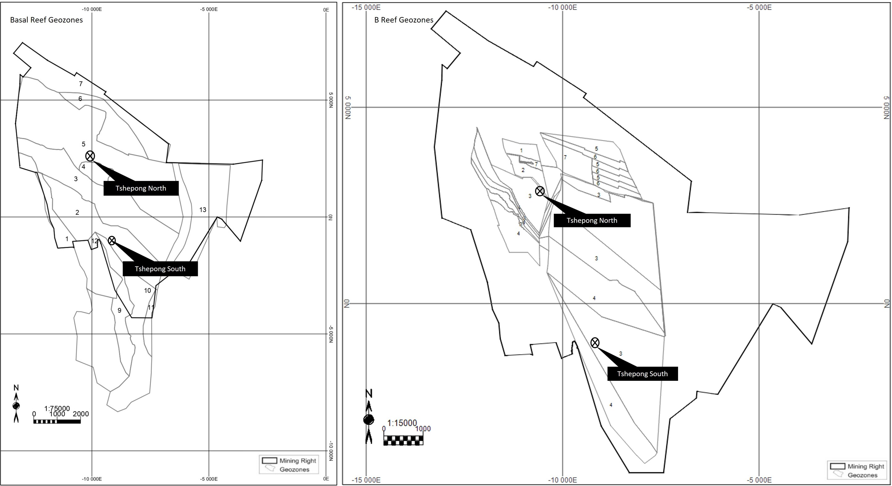
Effective Date: 30 June 2026
52
Technical Report Summary for
Tshepong North, Free State Province, South Africa
Table 11-2: Capping Values by Reef and Geozone
Geozone | Gold Cut (cmg/t) (Max) | CW Cut (cm) (Max) | Geozone | Gold Cut (cmg/t) (Max) | CW Cut (cm) (Max) | |
Basal Reef | B Reef | |||||
1 | 2,272 | 20 | 1 | 8,002 | 170 | |
2 | 4,023 | 123 | 2 | 4,474 | 218 | |
3 | 6,194 | 137 | 3 | 5,201 | 217 | |
4 | 2,511 | 20 | 4 | 11,378 | 210 | |
5 | 4,427 | 37 | 5 | 10,510 | 199 | |
6 | 3,279 | 27 | 6 | 15,433 | 171 | |
7 | 1,528 | 33 | 7 | 26,112 | 227 | |
8 | 5,073 | 77 | ||||
9 | 3,408 | 98 | ||||
10 | 7,762 | 65 | ||||
11 | 3,956 | 58 | ||||
12 | 4,893 | 40 | ||||
13 | 1,218 | 46 | ||||
11.8Mineral Resource Estimation Methods and Parameters
Grade and thickness estimates are undertaken within each geozone and informed by statistical and
geostatistical analysis. Two variables are estimated namely; gold accumulation (cmg/t) (which factors in both
the thickness of the reef thickness and grade) and channel width. No change of support corrections is
considered necessary as it is assumed that the differing support sizes for chip samples and drill hole samples
are negligible.
The orientations and ranges of each geozone’s semi-variogram are used to determine the optimized set of
kriging estimation parameters. The search ellipse is aligned with respect to its range and direction, to the
direction of the associated semi-variogram, as well as the range distances.
The Basal reef Measured Mineral Resource estimates are undertaken using OK. Estimates are generally
kriged into 30m x 30m blocks for the Measured Mineral Resource from the point support data.
Indicated and Inferred Mineral Resource estimates are undertaken using SMK. The Indicated Mineral
Resource is kriged into 60m x 60m block sizes. The Inferred Mineral Resource is estimated using the
associated regularized variograms and kriging into 120m x 120m blocks. Any un-kriged areas in the Inferred
Mineral Resource areas are then covered by global mean estimates.
The B Reef Measured Mineral Resource estimates are undertaken using OK. Estimates are generally kriged
into 15m x 15m blocks for the Measured Mineral Resource from the point support data. Indicated and
Inferred Mineral Resource estimates are undertaken using SMK. The Indicated Mineral Resource is kriged
into 30m x 30m block sizes. The Inferred Mineral Resource is estimated using the associated regularized
variograms and kriging into 60m x 60m blocks. Any un-kriged areas in the Inferred Mineral Resource areas
are then covered by global mean estimates. B Reef is estimated into smaller blocks due to high variability
which is common to the grade distribution
The results of the Basal and B Reef estimation are shown in Figure 11-2, for Tshepong North and South.
The current minimum and maximum sample points for the Basal Reef is:
•12 and 25 for the Basal Reef Measured Mineral Resource estimation;
•8 and 20 for Indicated Mineral Resource estimation; and
•3 and 10 for the Inferred Mineral Resource estimation.
The current minimum and maximum sample points for the B Reef is:
•11 and 30 for Measured Mineral Resource estimation;
•8 and 20 for Indicated Mineral Resource estimation; and
•3 and 10 for the Inferred Mineral Resource estimation.
Effective Date: 30 June 2026
53
Technical Report Summary for
Tshepong North, Free State Province, South Africa
Any un-kriged areas in the Inferred Mineral Resource category regions are then estimated using a global
mean.
Effective Date: 30 June 2026
54
Technical Report Summary for
Tshepong North, Free State Province, South Africa
Figure 11-2: Tshepong operations Basal Reef and B Reef Estimation Results
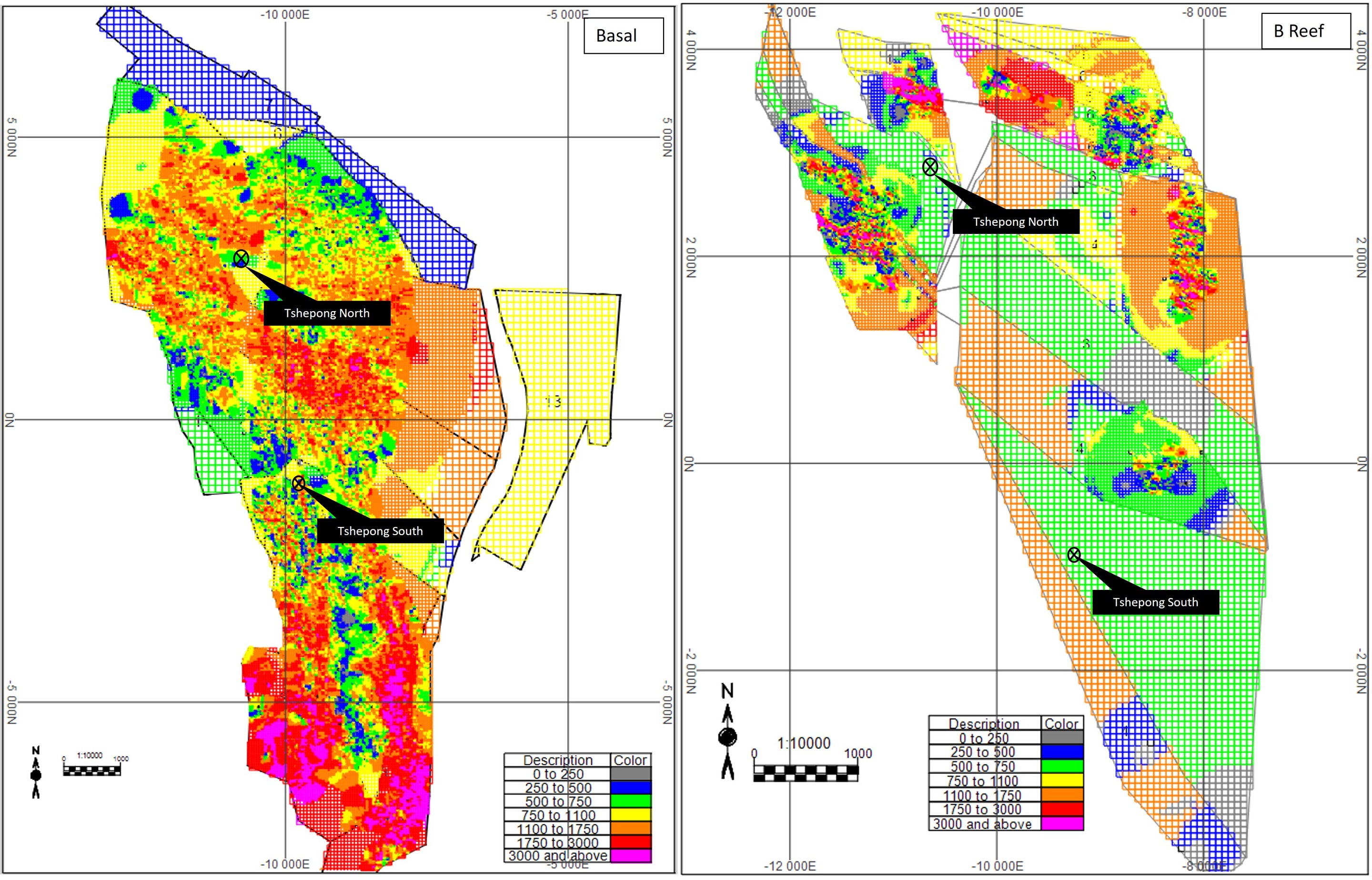
Effective Date: 30 June 2026
55
Technical Report Summary for
Tshepong North, Free State Province, South Africa
The Measured Mineral Resource model is constrained using the Slope of Regression Estimation Confidence
and merged with the Indicated Mineral Resource and Mineral Resource models to produce a combined
kriged block model.
The channel width is estimated for all block sizes and ranges between 8cm and 34cm, averaging 18cm for
Basal Reef. For B Reef, the channel width ranges between 10cm and 120cm and averages 80cm.
11.9Density Assignment
The relative density currently used for tonnage calculations at Tshepong North is 2.72t/m³. Reef volume is
determined by block area multiplied by the thickness estimate. The tonnage of each reef horizon is
determined by multiplying the volume by the relative density.
11.10Model Validation
The QP validated the Tshepong North Mineral Resource model using the following:
•visual comparisons with the raw drill hole data;
•comparisons of the raw drill hole data statistics with the model statistics;
•model volume; and
•visual assessment of the block model with drill hole intersections to ensure that the grades are locally
honoured by the model.
The QP did not identify any critical errors in the block model.
11.11Mineral Resource Evaluation
The Mineral Resource estimate for Tshepong North done by the QP is considered to have reasonable
prospects for eventual economic extraction. The cut-off value for the Mineral Resources is determined at
661cmg/t, for the gold based on the economic assumptions presented in Table 11-3 at the effective date
30 June 2026. This cut-off value represents typical costs for the mining method and preliminary mining and
metallurgical recovery assumptions.
Table 11-3: Harmony Economic Assumptions (30 June 2026)
Tshepong North | ||
Description | Unit | Value |
Gold price | USD/oz | 3,061 |
FX rate | ZAR:USD | 17.60 |
Gold price | ZAR/kg | 1,730,000 |
Plant recovery factor | % | 95.60 |
Unit cost | ZAR/t | 5,268 |
Notes: Unit cost includes cash operating cost, royalty and ongoing development capital
The gold price was derived by the Harmony Executive Committee at Head Office. Based on a market study
findings the QP agrees on pricing and considers the price to be appropriate for Mineral Resource estimation
and is slightly higher than that used for estimating Mineral Reserves (USD2,915/oz). The operating costs
(both mining and processing) are based on historical performance and budget.
11.12Mineral Resource Classification and Uncertainties
The Tshepong North Mineral Resources have been classified into Measured, Indicated and Inferred
categories, according to the S-K 1300 definitions. The classification is based on geological and geostatistical
confidence.
For the geostatistical confidence, the Measured Mineral Resource model is constrained by the Slope of
Regression Estimation Confidence, and the Indicated and Inferred Mineral Resource models are constrained
by their kriging estimation parameters.
Effective Date: 30 June 2026
56
Technical Report Summary for
Tshepong North, Free State Province, South Africa
The QP then considers if the geostatistical confidence boundaries require modification based on the
geological confidence in an area. The geological confidence could include confidence in the sedimentary
facies and mineralization model, or confidence in the structural model.
Mineral Resources are discounted by a geological loss to account for unknown but anticipated fault loss. The
discounts used for the Basal Reef are between:
•1% and 3% for Measured Mineral Resources;
•3% and 11% for Indicated Mineral Resources; and
•7% and 60% for Inferred Mineral Resources.
Similar information applies to the for B Reef.
Factors that may affect the Mineral Resource estimates include the following:
•gold price assumptions;
•exchange rate assumptions;
•operating and capital cost assumptions;
•gold recovery assumptions;
•geology-related risks; and
•operational risks.
11.13Mineral Resource Estimate
The Mineral Resources for Tshepong North were originally prepared, classified and reported according to
SAMREC, 2016. For the purposes of this TRS, the Mineral Resources have been classified in accordance with
§ 229.1302(d)(1)(iii)(A) (Item 1302(d)(1)(iii)(A) of Regulation S-K).
The location of the Basal Reef Mineral Resources across Tshepong North are presented in Figure 11-3. The
location of the B Reef Mineral Resources is shown in Figure 11-4.
The QP compiling the Mineral Resource estimate for Tshepong North is Mr A Louw, Ore Reserve Manager at
Tshepong North and employee of Harmony. The Mineral Resource estimate for Tshepong North, as at June
30, 2026 , exclusive of Mineral Reserves, is summarized in Table 11-4.
Effective Date: 30 June 2026
57
Technical Report Summary for
Tshepong North, Free State Province, South Africa
Figure 11-3: Location and Classification of Tshepong North Mineral Resources and Mineral Reserves for the Basal Reef
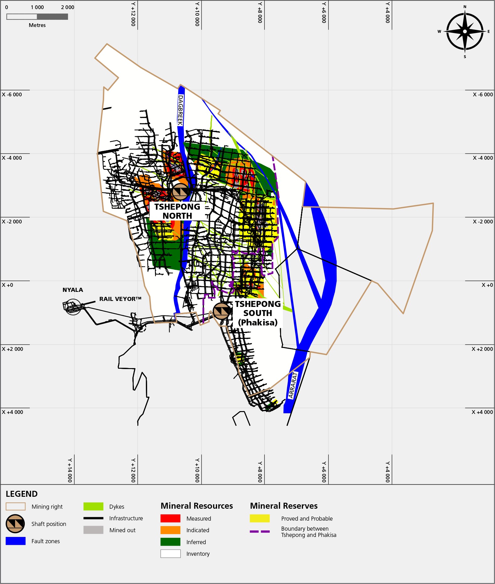
Effective Date: 30 June 2026
58
Technical Report Summary for
Tshepong North, Free State Province, South Africa
Figure 11-4: Location and Classification of Tshepong North Mineral Resources and Mineral Reserves for the B Reef
Effective Date: 30 June 2026
59
Technical Report Summary for
Tshepong North, Free State Province, South Africa
Table 11-4: Summary of Tshepong North Mineral Resources as at 30 June 2026 (Exclusive of Mineral Reserves) 1-8
METRIC | |||
Mineral Resource Category | Tonnes (Mt) | Gold Grade (g/t) | Gold Content (kg) |
Measured | 11.385 | 11.87 | 135,110 |
Indicated | 4.956 | 12.31 | 60,986 |
Total / Ave. Measured + Indicated | 16.341 | 12.00 | 196,096 |
Inferred | 7.578 | 10.20 | 77,309 |
IMPERIAL | |||
Mineral Resource Category | Tons (Mst) | Gold Grade (oz/st) | Gold Content (Moz) |
Measured | 12.550 | 0.346 | 4.344 |
Indicated | 5.463 | 0.359 | 1.961 |
Total / Ave. Measured + Indicated | 18.013 | 0.350 | 6.305 |
Inferred | 8.354 | 0.298 | 2.486 |
Notes:
1. Mineral Resources are reported with an effective date of 30 June 2026 and were originally prepared, classified and reported according
to SAMREC, 2016. For the purposes of this TRS, the Mineral Resources have been classified in accordance with § 229.1302(d)(1)(iii)(A)
(Item 1302(d)(1)(iii)(A) of Regulation S-K). The QP responsible for the estimate is Mr A Louw, who is Ore Reserve Manager at Tshepong
North, and a Harmony employee.
2. The Mineral Resource tonnes are reported as in-situ with reasonable prospects for eventual economic extraction.
3. The Mineral Resources are reported using a cut-off value of 661cmg/t determined at a gold price of USD3,061/oz
4. Tonnes are reported as rounded to three decimal places. Gold values are rounded to zero decimal places.
5. Mineral Resources are exclusive of Mineral Reserves. Mineral Resources are not Mineral Reserves and do not necessarily demonstrate
economic viability.
6. Rounding as required by reporting guidelines may result in apparent summation differences.
7. The Mineral Resource estimate is for Harmony’s 100% interest.
11.14Mineral Resource Reconciliation
Tshepong North Measured and Indicated Mineral Resource gold content estimate, exclusive of Mineral
Reserves, decreased by 0.945Moz from 7.250Moz gold as at June 2025 to 6.305Moz gold as at June 2026. The
decrease is primarily attributable to mining depletion and the conversion of Mineral Resources to Mineral
Reserves, with the impact partially offset by classification improvements and updated geological modelling.
11.15Comment on Mineral Resource Estimates
The QP is of the opinion that Mineral Resources were estimated using industry accepted practices and
conform to SAMREC, 2016. The Mineral Resources have also been reported in accordance with the S-K 1300
guidelines.
There are no other environmental, legal, title, taxation, socioeconomic, marketing, political or other relevant
factors known to the QP that would materially affect the estimation of Mineral Resources that are not
discussed in this TRS.
Effective Date: 30 June 2026
60
Technical Report Summary for
Tshepong North, Free State Province, South Africa
12Mineral Reserve Estimate
Section 229.601(b)(96)(iii)(B)(12) (i-vi)
The reported Mineral Reserves are derived through a business planning process and consideration by the
Chief Operating Decision-Maker (“CODM”) and the QP. The business planning process comprises multi-
functional reviews inclusive of all mining, support and service departments that are involved in the
verification of the inputs and the Modifying Factors. The CODM consists of various executive roles and
responsibilities. These executives assess the profitability, the revenue and production costs. The CODM also
considers capital expenditure, gold production and tonnes milled when assessing the overall economic
sustainability.
12.1Tshepong North
12.1.1Key Assumptions, Parameters, and Methods Used to Estimate the Mineral Reserve
The results and assumptions derived from the business planning process extends over an 18-month period.
The planning process carefully considers strategic plan directives; analysis of historical performance; realistic
productivity, and cost parameters; Modifying Factors; and technical and economic studies that have
demonstrated justified extraction, as applicable to specific portions of the Mineral Reserves.
All reported Mineral Reserves originate from the Basal Reef and the B Reefs. The Mineral Reserves are
considered based on several factors, including:
•the latest geological structure and associated Mineral Resource estimation models that constrain the
layout for the mine design and LOM planning;
•the need for regional rock engineering stability pillars;
•the extent of pillar mining, mining of remnant areas, reclamation of broken ore out of old areas,
tailings, or any other source;
•the SGM method in use,
•the sources of dilution and other dilution and other Modifying Factors; and
•only Measured and Indicated Mineral Resources are used to derive Mineral Reserves.
A combination of modelling exercises forms an integrated model informing the Mineral Reserve plan and the
Tshepong North Mineral Reserves estimates, and includes the:
•geological block model;
•structural model depicting prominent geological features;
•isopach model highlighting the mine’s sedimentology and shale formations; and
•geotechnical model including interpreted data, modelled in the form of support pillars.
12.1.2Modifying Factors
The Modifying Factors used to convert the Mineral Resource to a Mineral Reserve for Tshepong North are
presented in Table 12-1. The Modifying Factors are consistent with the modelling, planning and computing
estimates used in determining the Mineral Reserves, which are also consistent with historical performance.
The plant recovery as shown in Table 12-1, is also consistent with the processing and recovery methods.
Effective Date: 30 June 2026
61
Technical Report Summary for
Tshepong North, Free State Province, South Africa
Table 12-1: Tshepong North Modifying Factors Used for Mineral Reserve Determination
Modifying Factor | Unit | Value |
Relative Density | t/m3 | 2.72 |
Stoping Width | cm | 125 |
Gully | % | 8.09 |
Off Reef | % | 4.81 |
Waste to Reef | % | 3.71 |
Flushing tonnes | % | 2.53 |
Discrepancy | % | 8.41 |
Mine Call Factor | % | 68.00 |
Plant Recover Factor | % | 95.60 |
Mine Recover Factor | % | 65.01 |
Plant Call Factor | % | 100.00 |
Mineral Reserve cut-off | cmg/t | 717 |
Notes: Development waste to reef, including the decline development.
12.1.3Mineral Reserve Estimate
The Mineral Reserves for Tshepong North were originally prepared, classified and reported according to
SAMREC, 2016. For the purposes of this TRS, the Mineral Reserves have been classified in accordance with §
229.1302(e)(2) (Item 1302(e)(2) of Regulation S-K). No significant differences were observed.
The location of the Basal and B Reef Mineral Reserves are presented in Figure 11-3 and Figure 11-4.
The QP compiling the Mineral Reserve estimate for Tshepong North is Mr A Louw, Ore Reserve Manager at
Tshepong North and employee of Harmony. The Mineral Reserve estimate for Tshepong North, as at
30 June 2026 is summarized in Table 12-2.
Table 12-2: Summary of Tshepong North Mineral Reserves as at 30 June 2026 1-5
METRIC | |||
Mineral Reserve Category | Tonnes (Mt) | Gold Grade (g/t) | Gold Content (kg) |
Proved | 4.143 | 5.26 | 21,772 |
Probable | 6.423 | 4.96 | 31,828 |
Total (Proved + Probable) | 10.566 | 5.07 | 53,601 |
IMPERIAL | |||
Mineral Reserve Category | Tons (Mst) | Gold Grade (oz/st) | Gold Content (Moz) |
Proved | 4.566 | 0.153 | 0.700 |
Probable | 7.080 | 0.145 | 1.023 |
Total (Proved + Probable) | 11.647 | 0.148 | 1.723 |
Notes:
The Mineral Reserves were originally prepared, classified and reported according to SAMREC, 2016. For the purposes of this TRS, the
Mineral Reserves have been classified in accordance with § 229.1302(e)(2) (Item 1302(e)(2) of Regulation S-K). The QP responsible for
the estimate is Mr A Louw, who is Ore Reserve Manager at Tshepong North, and a Harmony employee.
2. Tonnes, grade, and gold content are declared as net delivered to the mills.
3. Figures are fully inclusive of all mining dilutions, gold losses and are reported as mill delivered tonnes and head grades. Metallurgical
recovery factors have not been applied to the reserve figures
5. Mineral Reserves are reported using a cut-off grade of 717cmg/t determined using a gold price of USD2,915/oz.
6. Rounding as required by reporting guidelines may result in apparent summation differences.
In the opinion of the QP, given that Tshepong North is an established operation, the modifying factors
informing the Mineral Reserve estimates would at a minimum, satisfy the confidence levels of a
Feasibility Study.
The declared Mineral Reserves are planned for depletion to generate Tshepong North cash flow. The
economic analysis of the cash flows displays positive discounted NPV results and is deemed both technically
and economically achievable.
12.1.4Mineral Reserve Reconciliation
The declared Mineral Reserve increased from 0.654Moz as at 30 June 2025 to 1.723Moz as at 30 June 2026.
The increase in the Mineral Reserve is mainly due to the inclusion of the ESU B Reef block and the Sub 75
Basal Reef reserve blocks following the approval of the Tshepong North Life of Mine Extension Project. This
Effective Date: 30 June 2026
62
Technical Report Summary for
Tshepong North, Free State Province, South Africa
increase was partially offset by normal depletion and a technical refinement in the design and scheduling
methodology.
12.2Commentary on Mineral Reserve Estimate
The Mineral Reserve is estimated at 10.566Mt of milled ore containing 1.723Moz as at 30 June 2026.
The declared Mineral Reserves take into consideration all modifying factors applicable to the mining area.
The declared Mineral Reserves are depleted to generate the Tshepong North cash flow. The discounted cash-
flow analysis produces positive results, and the Mineral Reserves are considered both technically and
economically achievable.
Any by-products that are recovered as part of the refining process, make up an immaterial component of the
total metal inventory, and is thus not reported as part of the Mineral Reserve estimate.
There are no obvious material risks that could have significant effect on the Mineral Reserves.
In the opinion of the QP, given that Tshepong North mine is an established operation, the modifying factors
informing the Mineral Reserve estimates would at a minimum, satisfy the confidence levels of a Feasibility
Study.
Effective Date: 30 June 2026
63
Technical Report Summary for
Tshepong North, Free State Province, South Africa
13Mining Methods
Section 229.601(b)(96)(iii)(B)(13) (i-v)
Tshepong North may be classified as moderate to deep level underground gold mine currently operating at
depths of up to 2,500m below surface.
13.1Mining Operations
Tshepong North operates using a single main shaft (see Figure 3-2). This shaft functions independently in
terms of ventilation requirements but relies entirely on Tshepong South for secondary escape routes. In the
upper mine, Tshepong North and South are interconnected at the 55 and 66 levels, while in the lower mine,
all levels from 69 to 75 are interconnected. Further details regarding shaft operations, interdependencies,
and railway systems are provided in Section 15.
13.1.1Tshepong North
The Tshepong North Mine is a mature underground section and is made up of two mineable reefs namely the
Basal Reef and B Reef. The reefs at Tshepong North are accessed via a single underground vertical shaft and a
twin decline system.
Currently eleven working levels are being mined from the Tshepong North Shaft. Seven in the upper mine
and four working levels are being mined in the lower mine , also known as the decline. The decline system
was constructed as a 1,700m extension to access the Basal Reef and recently the B Reef.
The characteristics of the Basal Reef at the Tshepong North Mine are synonymous to the characteristics of
the reef at the Tshepong South Mine. Tshepong North Mine extracts the Basal Reef via undercut mining
methods, leaving a quartzite beam in the hanging wall to ensure the stability of the overlaying Khaki shale.
The B Reef is stratigraphically located approximately two production levels (145m) above the Basal Reef. The
reef occurs in three facies, with channel widths ranging from 30cm to 170cm, and is characterised by variable
but often high-grade mineralisation. Historically, B Reef mining contributed a relatively small proportion of
the production profile due to limited geological confidence and the erratic distribution of mineralised zones.
Continued exploration drilling, improved geological understanding and successful delineation of the
mineralised channels have significantly increased confidence in the B Reef orebody. As a result, the B Reef
has become the primary production horizon at Tshepong North and currently contributes approximately 60%
of the operation’s production volume. The B Reef is mined using open stoping methods and is supported by
dedicated footwall infrastructure development aligned to its stratigraphic position.
Structurally, the Dagbreek Fault is the most prominent feature at the Tshepong North Mine, and largely hosts
the shaft infrastructure. Since the Tshepong North Shaft is in a fault loss zone, there is no associated shaft
pillar.
13.1.2Sequential Grid Mining (“SGM”)
SGM is the preferred mining method used at Tshepong North. This method makes use of dip pillars and
reduced mining spans with pre-developed tunnels, aimed at further control of stresses experienced in rock
movement.
The SGM sequence is a V-shaped configuration, colloquially referred to as the “inverted Christmas tree”. A
schematic representation of the SGM sequence used at Tshepong North is shown in Figure 13-1.
The SGM mining methods are suitable for underground, narrow reef mining. A common feature of the SGM
method is the layout of the primary and secondary development. Primary development is done off-reef (in
waste rock), while secondary development is done on-reef (in the mineralized zone). In primary
development, horizontal haulages are developed from the vertical shaft, extending to the extremities of the
mining level. Inter-level spacing is the perpendicular distance between two consecutive level stations
underground. Further development is done at set intervals along the haulages towards the mineralized zones
in the form of crosscuts. For secondary development, an inclined excavation that connects two levels is
established, referred to a raise or winze, depending on the upwards or downwards direction of the
development.
The SGM is employed for a deeper mining approach and offers various advantages, the critical one being
increased safety. A noticeable characteristic of the SGM method is that mining from the raises is advanced in
Effective Date: 30 June 2026
64
Technical Report Summary for
Tshepong North, Free State Province, South Africa
only one direction at a time, which is directed towards the stabilizing or regional pillars. This SGM mining
sequence eliminates the creation of remnant pillars reducing the risk of seismicity.
Effective Date: 30 June 2026
65
Technical Report Summary for
Tshepong North, Free State Province, South Africa
13.1.3Open Stoping
While Tshepong North business plan is based primarily on the SGM methodology and sequencing, there are
sections of the mine that are operating using the breast, undercut and open stoping mining methods.
B Reef mining currently contributes approximately 60% of Tshepong North's production volume and has
become the primary production horizon at the operation. The increase in B Reef contribution is a result of
improved geological confidence gained through extensive exploration drilling, underground development
exposure and a better understanding of the mineralised channel distribution. Due to the variable channel
width and support requirements associated with B Reef mining, the reef is extracted using open stoping
methods. The mining areas are supported by dedicated footwall infrastructure developed specifically for the
B Reef horizon. In addition, the location of the B Reef mining areas results in a relatively low geotechnical risk
compared to other mining sections of the operation
13.1.4Breast Mining
A key feature of breast mining is that the mine design includes pillars in the stoping areas that are designed
to cave in a planned and controlled manner. These pillars are referred to as crush pillars and the dimensions
of the pillars are determined by the geotechnical properties of the host rock. The use of crush pillars
minimizes the risk of unpredicted collapse of stoping areas. These collapses can compromise the safety of
mining operations and may lead to permanent closure of stoping panels or sterilization of ore.
The breast mining method has consequently evolved into the SGM.
13.1.5Integrated Approach
The differences of the reef formations and mining conditions at the respective shafts have led to the
application of an integrated mining method approach. The objective of the adopted mining methods is aimed
at the safe and profitable extraction of the Mineral Reserves, while reducing the occurrence of large seismic
events.
13.2Mine Design
The mine design strategy at Tshepong North Mine is focused on maximizing the safe extraction of ore while
minimizing the risk of geotechnical failures, which can lead to operational disruptions and hazardous working
conditions. The Basal Reef is meticulously modelled and designed across Tshepong North, with the B Reef
also being considered for design and planning purposes.
Both the Basal and B Reef horizons have experienced faulting and intrusions by igneous dykes and sills that
intersect the reefs. To mitigate the risks of rockfalls and rockbursts, Tshepong North employs systematic
modelling and design processes. An integrated support system is implemented, which includes dip stabilizing,
bracket, and strike pillars. The central raise line is maintained for stability during stoping operations through
the use of support packs. Additionally, in-stope net support is provided for both the Basal Reef and B Reef,
consisting of steel nets installed on the stope face and advance strike gullies. All footwall development is
similarly supported with steel nets on the face and side walls to prevent falls of ground.
Effective Date: 30 June 2026
66
Technical Report Summary for
Tshepong North, Free State Province, South Africa
Figure 13-1: Schematic Representation of the SGM Sequence
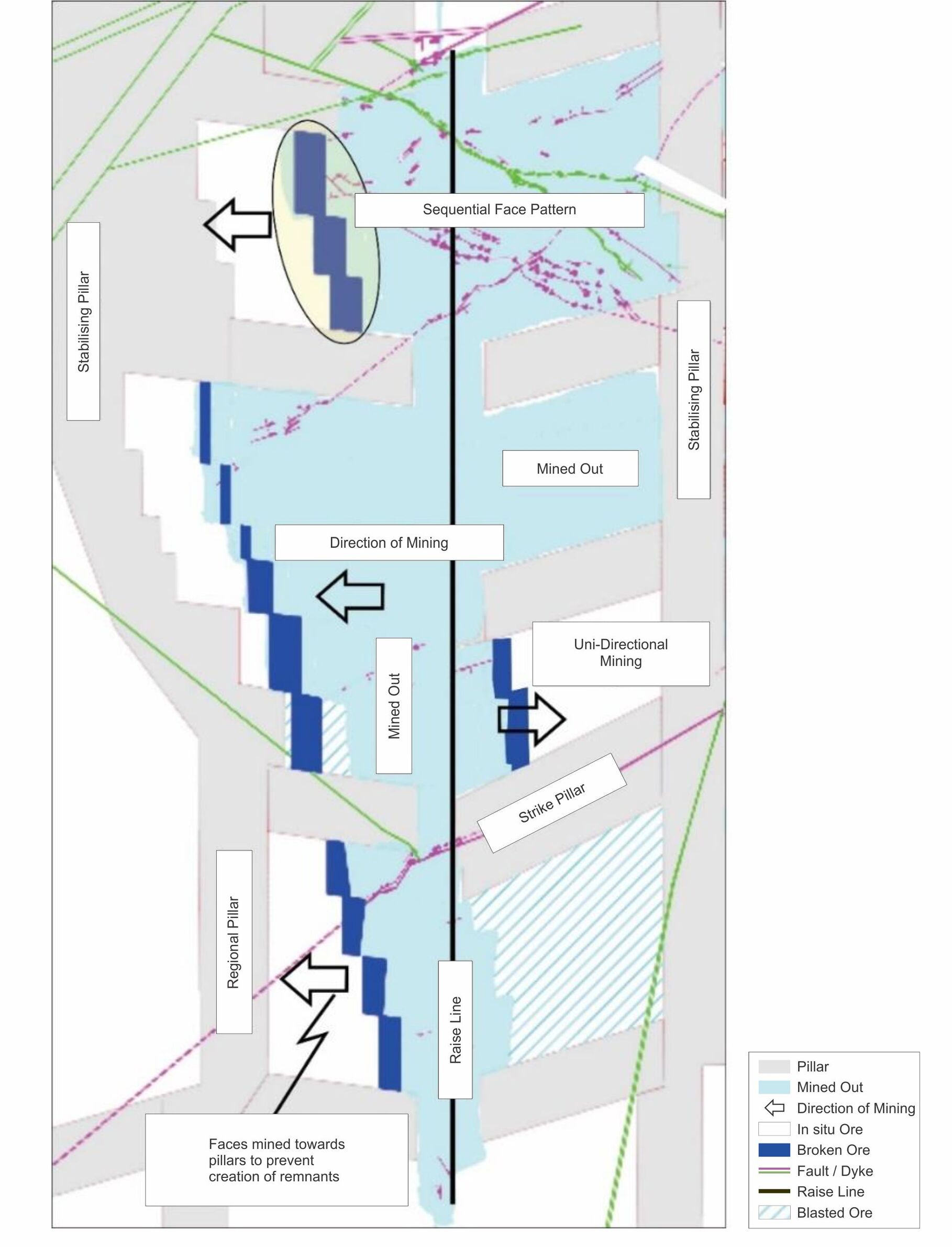
Effective Date: 30 June 2026
67
Technical Report Summary for
Tshepong North, Free State Province, South Africa
The occurrence of geological faults is also a source of groundwater intersections during mining operations
which may lead to production delays, geotechnical risks, and the potential of flooding. Depending on the
geology of the dyke or sill, a change in the mining direction may be required, or as in the case of low-risk
scenarios the Rock Engineering department may suggest a safety and support strategy to mitigate the
associated geotechnical risk. A change in mining direction may result in Mineral Resource losses, or an
increase in dilution.
Based on the latest geological structure model and the SGM method the geotechnical team design a suitable
pillar layout based on modelling results. A detailed mine design and schedule is done based on the pillar
design taking cognizance of uneconomical areas which are excluded on macro scale. This design and schedule
are the basis of the mine plan and the declared Mineral Reserves.
A mine design that is sufficiently informed, with geological data, is progressed to the mine planning phase.
Mine planning is done on a macro scale as well as on a micro scale. On a macro scale, the material below cut-
off is excluded from the mining model. On a micro scale, the mining model is then subject to constraints that
are applied because of the geotechnical design and other limitations.
The geotechnical modelling is driven by the most recent information from mining operations, which ensures
that the model is an accurate representation of the current operational conditions.
Development is done by either mechanized, mechanical or conventional method depending on the most
suitable method for the specific requirements. The Tshepong North Mine is essentially a conventional mine
design with trackless mining in the twin decline.
Mining production is accessed through underground excavations, developed as haulages and cross cuts.
Crosscuts are primary development, in the direction of the mine workings. Inclined secondary development is
used to access the reef contact, and advanced from the position of respective crosscuts. Ore is extracted
from stoping panels established from the inclined development.
13.2.1Mine Design Parameters
Mine design is conducted internally, with separate designs prepared for the Basal Reef and B Reef horizons
using Deswik™ software. The geological models and geotechnical parameters—such as seismicity, rock
formation, rock strength, and depth—formulated by the Rock Engineers, serve as the foundation for the
mine planning process. The geotechnical team develops suitable mining and support methods based on these
modelling results. This includes strategies for ledging and the implementation of bracket and strike pillars in
areas with seismic activity. A detailed mine design and schedule are then created, incorporating the modelled
fire and seismic pillars, as well as the leads, lags, and specific areas of interest. The mine design parameters
used for Tshepong North Mine, are shown in Table 13-1 (Section 7).
Table 13-1: Tshepong North Mine Design Parameters
Parameter | Unit | Value |
Regional Stability | ||
Dip stabilizing pillar dimensions | ||
Strike span | m | v |
Dip span | m | 180 |
Strike stability pillar spacing¹ | m | N/A |
Access haulages middling to reef | m | 90 |
Primary Development | ||
Advance | m/month | 30 |
Crosscut spacing | m | 200 |
Secondary Development | ||
Advance | m/month | N/A |
Stoping Parameters | ||
Stoping Width (channel width < 80cm) | m | 1.05 |
Stoping Width (channel width > 80cm) | m | 1.3 |
Economic Parameters | ||
Cut-off grade (planning) | cmg/t | 717 |
RD | 2.72 | |
Notes: 1. Pillar spacing is measured skin to skin.
Effective Date: 30 June 2026
68
Technical Report Summary for
Tshepong North, Free State Province, South Africa
13.3Geotechnical Considerations and Seismic Monitoring
Tshepong North maintains working geotechnical and Isopach models, to manage and control seismicity risk.
The geotechnical and Isopach models for Tshepong North take the latest geological structural model and the
SGM method into account to design a suitable pillar layout.
The purpose of the pillar designs, regardless of the pillar type, is to customize them to the prevailing mining
conditions, with the objective of making the mine design safe, practical, easy to implement, and profitable.
These pillars include dip stabilizing, bracket and strike pillars. The details of the pillar design can be found in
Table 13-1 Tshepong North Mine. The dimensions depicted for the pillars are standard and are adjusted
depending on planned bracketing of geological structures or if patches of low value reef are encountered.
The Rock Engineers follow the following geotechnical modelling and approach:
•evaluate the principal stress directions using seismic source mechanisms and update the input
parameters for numerical modelling;
•using seismic source mechanisms, delineate planar features to confirm and/or detect the position and
orientation of geological structures;
•confirm the expected ground motion produced by large, potentially damaging seismic events, and
calibrate the Ground Motion Prediction Equation; and
•monitor mine-wide seismic activity and test each geotechnical region for deviation from the expected
co-seismic rockmass response, which tests the release of seismic energy.
The geotechnical stress model is also used to manage and monitor the occurrence of seismic hazards. Seismic
hazards are categorically measured as per mine planning cycles of short, medium and long term. Events for
the last 100 - 200 days definitively estimated, to accurately determine the intermediate probabilities of
occurrence. The behaviour of identified medium term events are then monitored daily. Alarms are raised,
and people are evacuated in the event of a predicted or anomalous seismic pattern is identified and people
are removed from the specific danger areas.
Tshepong North Mine uses an Integrated Seismic System supplied by Institute of Mine Seismology to record
seismic events on the property.
The seismic systems consist of 24 three-component geophones. The digital seismic data is transmitted from
the underground seismic stations through to the surface monitoring stations via manual and automated
recording systems, based on available infrastructure at the mine. The data is recorded continuously and
reported on an annual basis.
13.4Geohydrological Considerations
Apart from the geotechnical risks that can be caused by the existence of geological structures, the presence
of water and gas also pose risks to Tshepong North. The geohydrological models are used as a basis to
manage and monitor the occurrence of ground water and gas intersections. Cover holes are drilled in all flat
development ends to identify water or gas. Water or gas intersections are plotted in a 1:200 survey sheet
plan and section view, with a detailed 1:100 profile description. These intersections are plotted against a
stope plan indicating the geology, structural features, reef contours, pillar layout, faults with associated
losses or gains, reef elevation, grade and channel width. These geospatial referenced plots significantly
enhance the mining team’s ability to execute the mine plan in accordance with the operation’s geotechnical
requirements. They also facilitate the early detection of water or gas presence.
Daily management of influx water is handled through a series of diversion strategies aimed at re-directing
and controlling the flow, temperature regulation, and re-circulation of water. The water strategies at
Tshepong North are supported by the Integrated Waste and Water Management Plan (“IWWMP”). Both
Tshepong North and South maintain graphical and numerical databases of the operations geohydrological
conditions.
Water reticulation around the mine has been designed to maximize water re-use minimize the amount of
water pumped to surface. The 76-level pump station is used to transfer water from various levels into small
inter-level dams and eventually into the mine’s respective main settling dams.
Effective Date: 30 June 2026
69
Technical Report Summary for
Tshepong North, Free State Province, South Africa
13.5Mine Plan Development and Schedule
Tshepong North Mine has significant Mineral Reserves to maintain a long-term mine life, however, extraction
of ore from isolated blocks of ground will become more important as the life of mine progresses, but
volumetrically these Mineral Reserves are not significant.
The preferred SGM mining method is dependent on development staying ahead of the mining front, so that
accurate geological information is gathered and included in final designs before mining commences. This also
enables, planning and scheduling activities to be accurately sequenced, which leads to better planning, safer
working conditions, and improved profitability.
At Tshepong North Mine, the Mineral Reserve plan and scheduling originates within the use of the Life of
Plan. The 10.566 Mt of Mineral Reserves are included in the plan and are fully accessible through the existing
infrastructure at the Tshepong North Mine. The mining rates used in determining the Mineral Reserve plan
are based on the current and expected operational performance, notwithstanding any unforeseen
underground mining constraints. The Mineral Reserve for the operation is planned for fifteen years, with a
planned mining rate averaging at approximately 0.776 Mtpa over the period. The milled ore and gold
recovered for Tshepong North Mine Mineral Reserves are presented in Figure 13-4 and Figure 13-5,
respectively.
Effective Date: 30 June 2026
70
Technical Report Summary for
Tshepong North, Free State Province, South Africa
Figure 13-2: Tshepong North Plan Basal
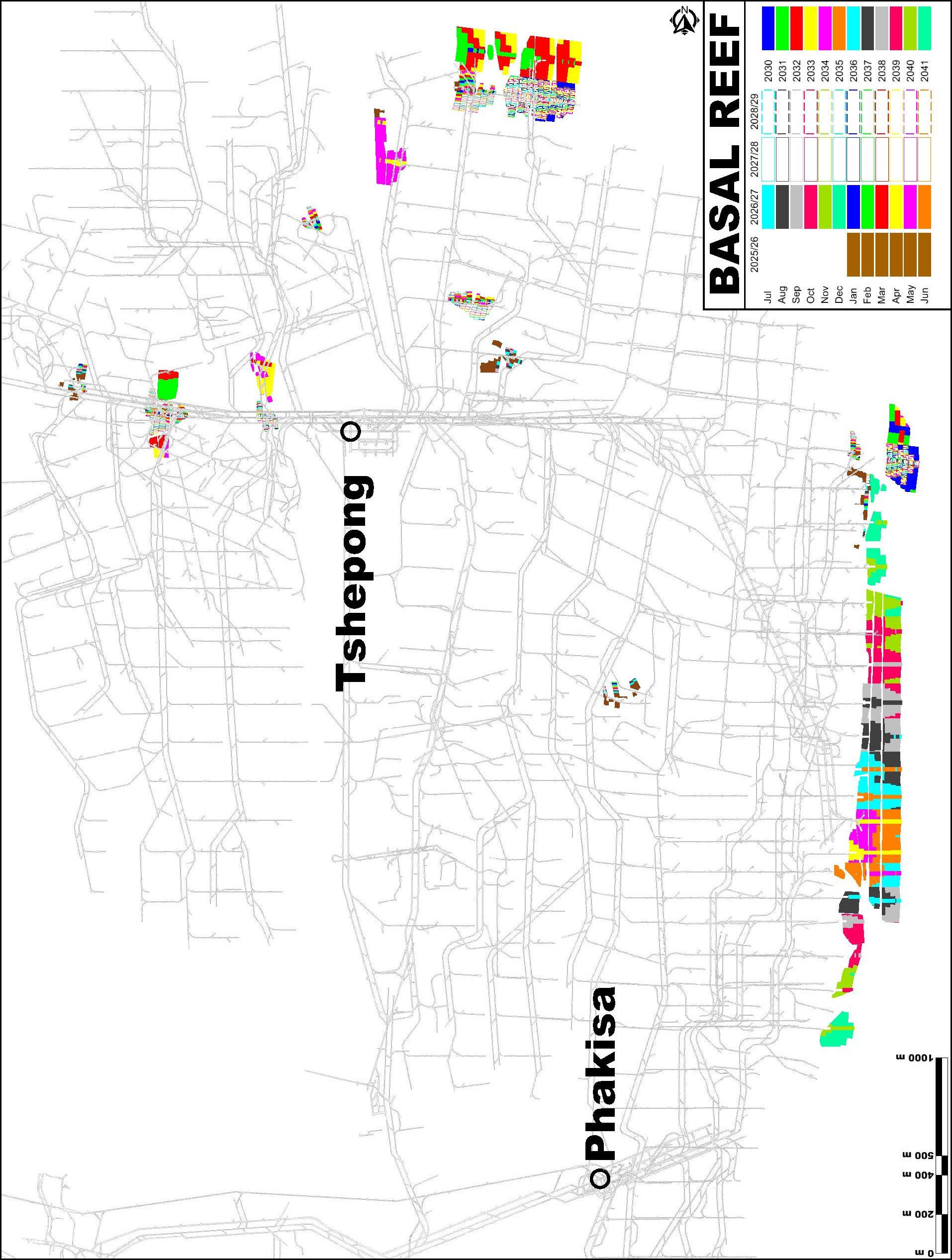
Effective Date: 30 June 2026
71
Technical Report Summary for
Tshepong North, Free State Province, South Africa
Figure 13-3: Tshepong North Plan B Reef
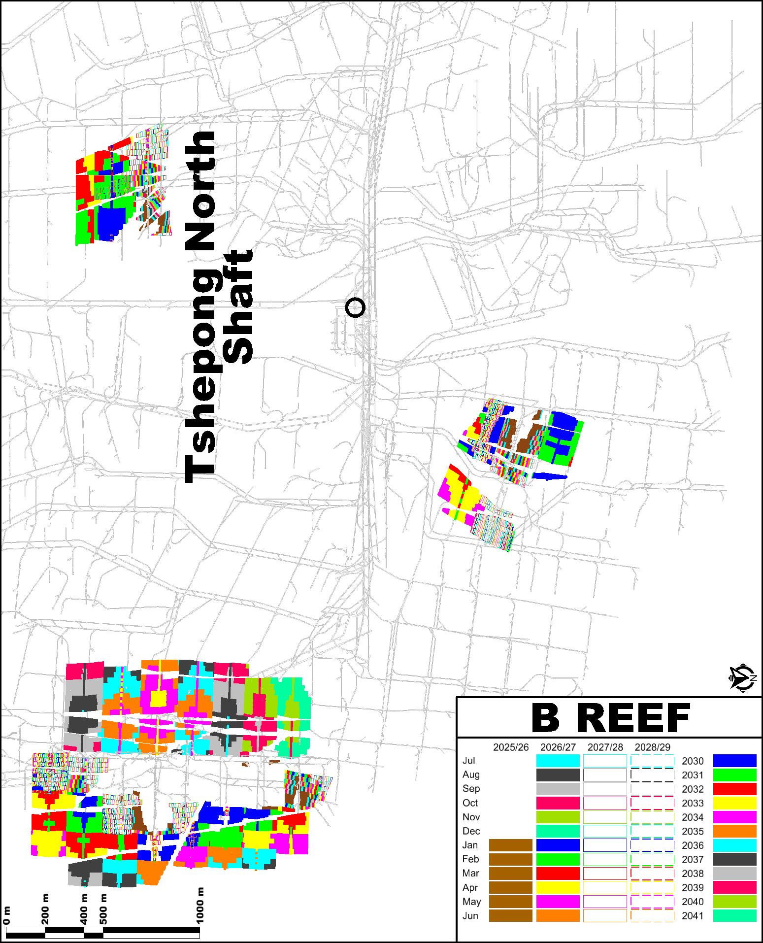
Effective Date: 30 June 2026
72
Technical Report Summary for
Tshepong North, Free State Province, South Africa
Figure 13-4: Graph of Tshepong North Mineral Reserve Plan – Tonnes and Grade
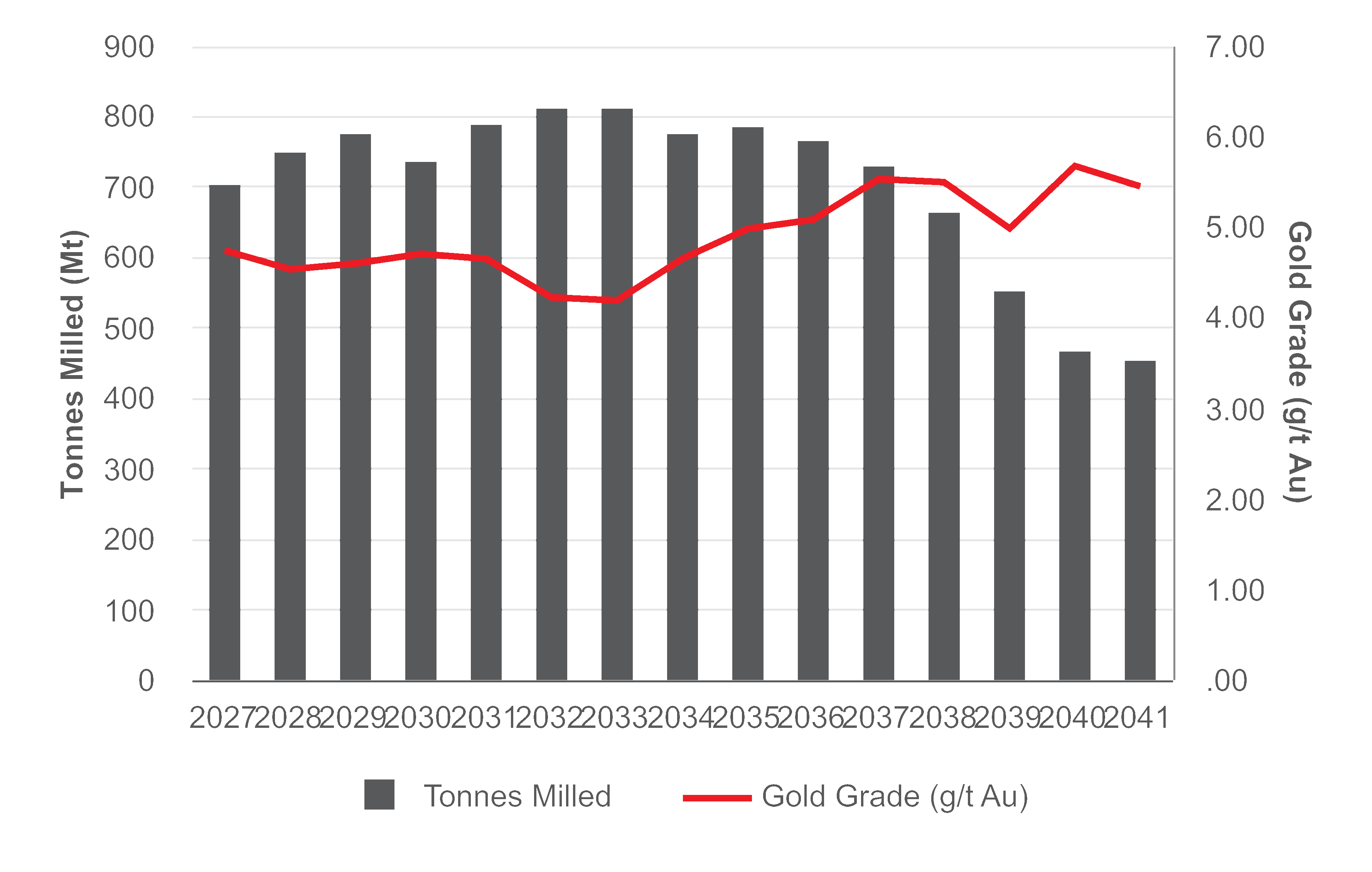
Figure 13-5: Graph of Tshepong North Mineral Reserve Plan – Gold Produced (kg)
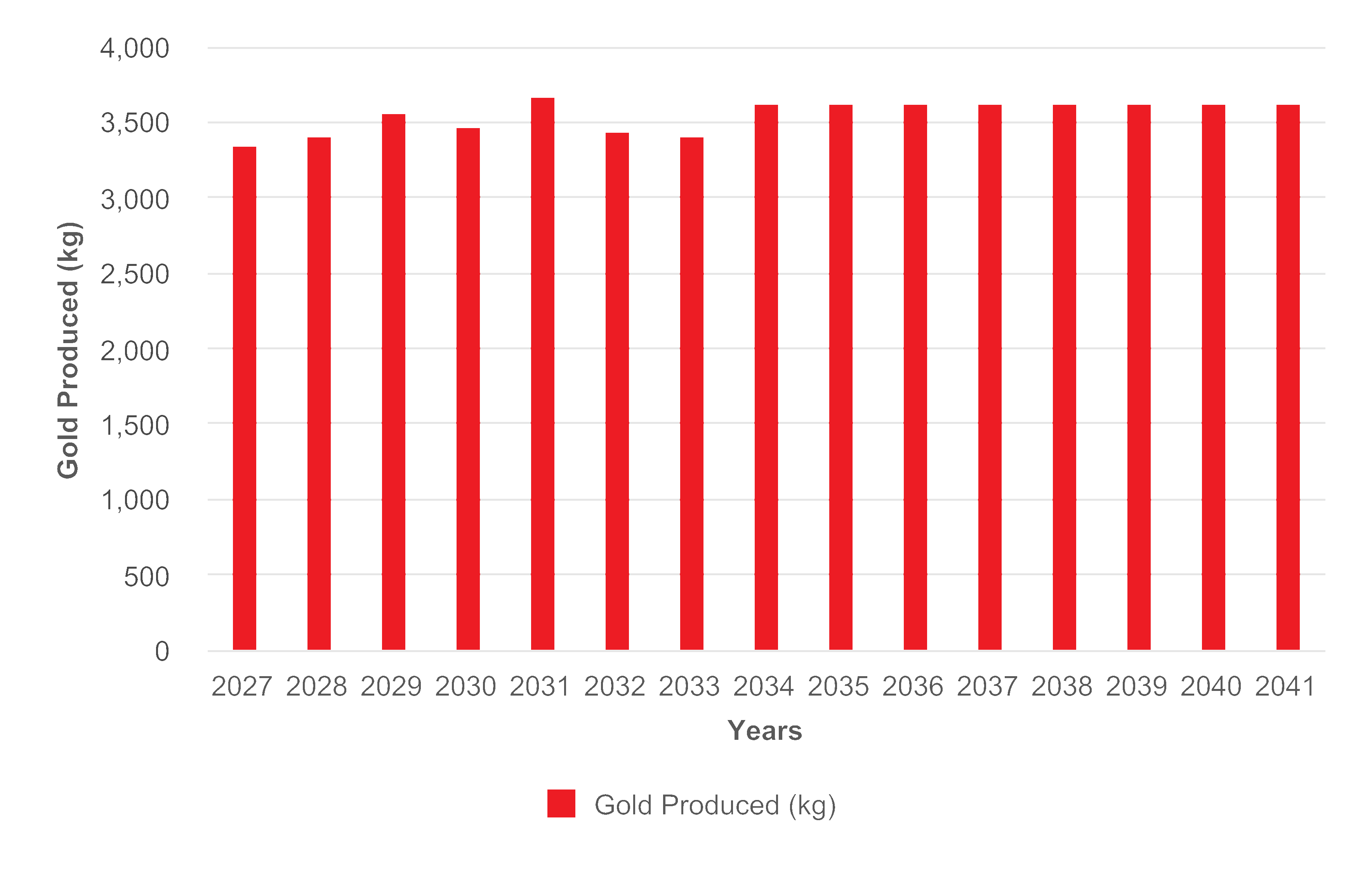
Effective Date: 30 June 2026
73
Technical Report Summary for
Tshepong North, Free State Province, South Africa
13.6Mining Rates
Mining rates are based on current and expected performance depending on underground conditions and
constraints. Dilution is included in the production plan mainly from external waste sources from the stoping
operations, but allowances are also made for dilution occurred in the ore flow process. The Mineral Reserve
plan considers the planned and available working areas, inclusive of the mine’s current infrastructure
capacity.
13.7Grade and Dilution Control
The selected SGM mining method is planned and designed to better support recovered grade because of the
improved selectivity, flexibility, and reduced off-reef mining. Mine grades are currently decreasing as mining
moves away from the central pay-shoot and the planned Life of Mine Extension Project ( Sub75 Basal Reef
and ESU B Reef blocks) is aimed at alleviating this risk.
Ore grade and dilution control is done using a Quality Index monitoring tool. This Quality Index considers key
parameters including Mine Call Factor, stoping width, proportion of ore lock-up, and an on-reef index
(percentage of On-Reef vs Off-Reef mining due to geological features such as faults and dykes, etc.). During
the mine design and planning process, external dilution control is implemented by applying an adapted mine
recovery factor.
Operationally, grade and dilution control are mostly achieved through improved drilling (marking sticks used
on undercut mining) and blasting practices and compliance to blasting barricades on stopes <35°. Drilling
accuracy is achieved by holes that are drilled parallel, aimed at being correctly burdened and that are within
the stoping limits. This ensures consistent and economic rock breaking, without dilution.
Tshepong North Mine introduced electronic blasting technology during FY24 which is a integrated electronic
system, which allows for precision timing and improved control of rock breaking. This technique controls
stoping width and protects the integrity of the footwall and hanging wall, aimed at minimizing dilution as well
as reducing seismic risk.
13.8Mining Equipment and Machinery
There are various machinery and equipment used at Tshepong North, depending on the type of mining or
development activity. The following equipment can be found at the frontline of mining production:
•haulages and associated development: he drilling process involves several steps, with handheld
drilling machines playing a crucial role in development production. These machines are manually
operated to drill blast holes in the rock face, allowing for precise control in confined spaces. In this
process, compressed air and water are essential components.
•production drilling in stopes: Two types of drilled holes are used in a stoping panel, namely production
drilling and pre-conditioned drilling. Pre-conditioning is a methodology aimed at transferring the
stresses away from the stope face, therefore reducing the potential for face burst damage. Pre-
conditioned holes are drilled longer than production holes and are blasted with the production round.
Equipment used for this type of drilling is compressed air hand-held drills;
•raise boring: Is a drilling technique used for ventilation development purposes and ore passes. Raise
boring and control mechanisms are currently operated via control modules connected through the
mine’s underground and shaft communication networks, conducted on surface by a contractor. The
benefits of this allow personnel to be removed from dangerous underground workings and have the
upside of productivity achieved through automation;
•rock movement: Ore from the stoping ore passes is loaded directly into hoppers from the box-front
chutes and then trammed to the shaft to the inter-level tips, then transferred to the main loading bins
for hoisting to the surface. Waste rock from development operations is loaded into similar hoppers
and trammed and hoisted in the same manner as the ore movement but is done using in a dedicated
waste system to prevent diluting the ore grade;
•material movement: Tshepong North uses the Battery charged monotrains and to a lesser extent
diesel monotrains. The monotrain was partially adopted at Tshepong North, decline operations due to
their consistent maintenance of speed in steep and changing gradients, while allowing for varying
weight bearing capacities, works as efficiently in undulating floor conditions, and is almost impossible
to de-rail due to the L-shaped sliding beam design.
Effective Date: 30 June 2026
74
Technical Report Summary for
Tshepong North, Free State Province, South Africa
•Small articulated dump trucks, graders, and crawler mounted bulldozers for dump, waste and
marginal ore movement also support the Tshepong North Mine operations.
13.9Ore transport
The blasted ore from the stoping panels is moved with winch-operated scrapers along gullies to ore passes
where it gravitates down to the loading boxes in the footwall crosscuts below the stopes. The ore is
discharged into rail hoppers and transported, via front-driven locomotives, to dedicated inter-level transfer
systems that gravity feed to the main silos with a capacity of 4,722t. Once hoisted up the main vertical shaft
to surface, the ore is transported to the Harmony One Plant via conveyor belt. Tshepong North shaft hoisting
capacity is designed at 220,000t per month.
13.10Mining Personnel
Tshepong North is labour intensive, with the mine being supported by approximately 4,165 employees, with
89% being permanent staff and the remainder contractors.
The underground mining operations uses an 11 day fortnight shift system, operating a 3-shift cycle per day.
The underground work force is essentially split into two categories that are either involved in production
activities or they provide supporting services required underground. Production activities are directly related
to the mining of ore and non-production personnel provide supporting services such as safety, engineering
functions, maintenance, decline conveyor management and underground store controls. The mining
personnel for Tshepong North is presented in Table 13-2.
Table 13-2: Tshepong North Mine Mining Personnel
Labour Requirement | No. of Employees |
Services | 386 |
Engineering | 851 |
Mining | 2,574 |
Contractors | 354 |
Total Employees | 4,165 |
Effective Date: 30 June 2026
75
Technical Report Summary for
Tshepong North, Free State Province, South Africa
Figure 13-6: Tshepong North Shaft and Underground Infrastructure
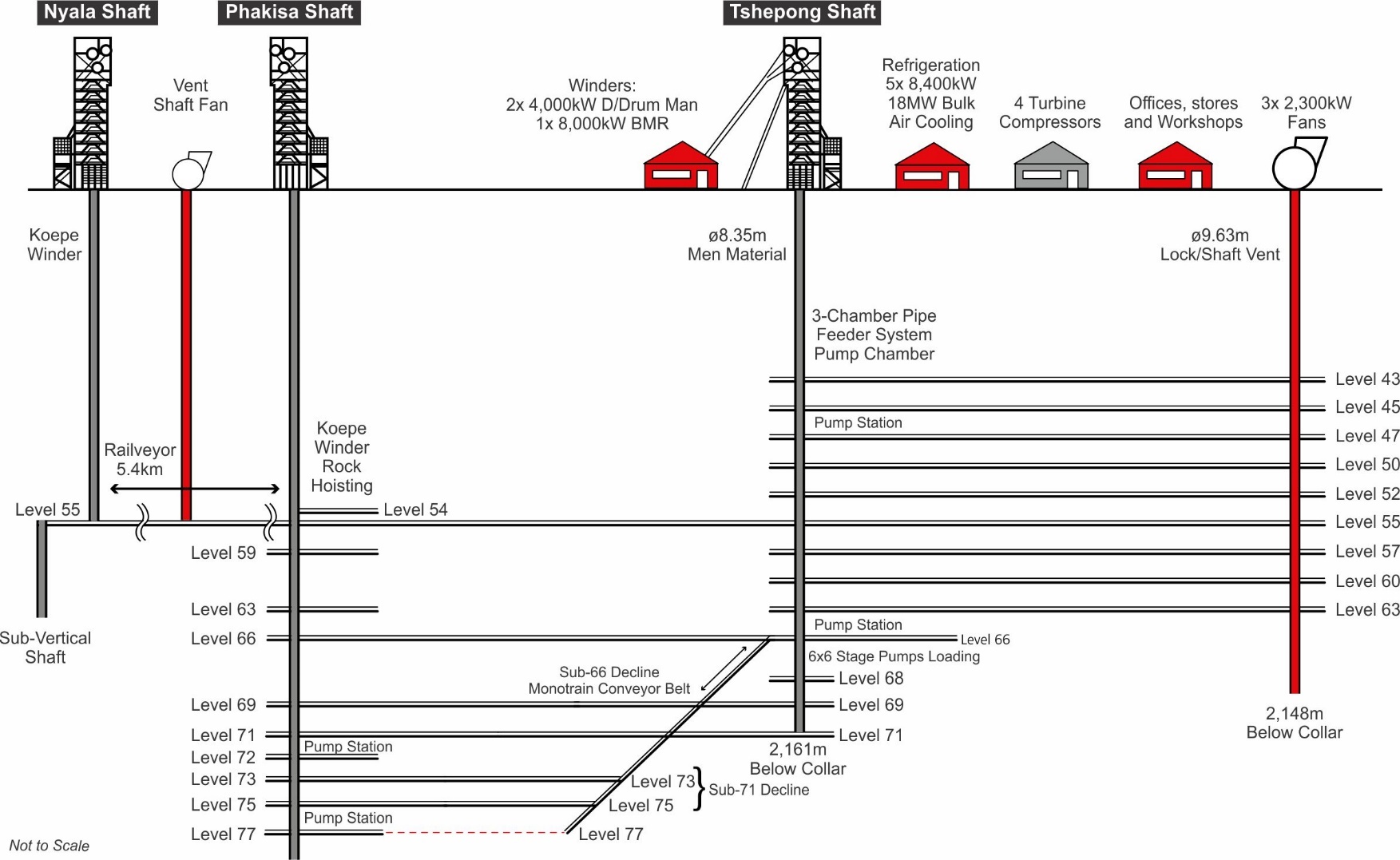
Effective Date: 30 June 2026
76
Technical Report Summary for
Tshepong North, Free State Province, South Africa
13.11Commentary on Mining Methods
The SGM mining method is the main mining method utilized at Tshepong North and is appropriate for the
reef characteristics and the mine depth. The mine design, planning and scheduling for the mine is developed
using the DatamineTM and DeswikTM geological software, respectively, considering the geotechnical model
and related parameters.
The main geotechnical and geohydrological risks at Tshepong North include the presence of gas, ground
water and seismicity, which are managed through the integrated monitoring systems, and incorporated into
working mining models that inform daily mine planning decision-making.
The mining rates, machinery and equipment, ore transport, grade and dilution control, and labour resourcing
and optimization are driven by the mine schedule and improvement initiatives.
Effective Date: 30 June 2026
77
Technical Report Summary for
Tshepong North, Free State Province, South Africa
14Processing and Recovery Methods
Section 229.601(b)(96)(iii)(B)(14) (i-iv)
All ore mined at Tshepong North is processed at Harmony One Plant located west of Welkom (Figure 3-1).
Harmony One Plant is Harmony’s largest gold processing plant and processes underground ore from multiple
shafts, as well as surface ore from nearby mine waste facilities. The plant was commissioned in 1986 and
comprises three independent modules, each consisting of four feed silos, two ROM mills, two conventional
thickeners, cyanide leach, carbon in pulp (“CIP”) adsorption, elution, zinc precipitation and smelting. The
plant CIP process reflects the technology which was current at the time of construction and has been
operating with no significant challenges and target metallurgical recoveries have been achieved.
14.1Mineral Processing Description
The processing flow sheet is presented in Figure 14-1.
Ore delivered to the plant is fed from the concrete silos via two mill feed conveyors through vibrating feeders
directly into the ROM mills. Fully autogenous (“FAG”) milling is a milling process in which the entire ROM ore
stream is fed directly into the mills and where the grinding media is generated within the mill from suitably
sized pieces of ROM ore itself. The average feed rate to the mills is 65tph. The milling circuit consists of two
single stage ROM mills that are controlled on maximum power for optimum milling. Each ROM mill is 4.27m
in diameter and 10m in length and grinds the ore to 75% - 90% passing minus 75 microns.
Milling is followed by a conventional gold leach process (cyanidation).The cyanidation process is one of the
most utilized methods for the recovery of gold from auriferous ores. The use of cyanide leaching for gold
recovery is based on gold’s properties, mainly its solubility (ability to dissolve) in cyanide solutions. Once the
gold is dissolved into the cyanide solution it has a higher ability to adsorb (attach) onto activated carbon
through the application of carbon in pulp (“CIP”) technology.
The loaded carbon then enters the elution columns, which are high pressure vessels that circulate the loaded
carbon extracting the gold. The gold will “de-absorb” from the activated carbon and attach onto stainless-
steel wool by means of electrowinning. The CIP circuit makes use of gravity flow of slime between the
consecutive counter-flow stages to recover recirculate the activated carbon back into the system.
Following this process, the cathode steel wool is smelted (induction furnaces) after drying in the calcining
ovens. The doré bars are then dispatched to Rand Refinery Limited, located near Johannesburg in Gauteng
Province.
The current TSF sites have a combined deposition rate of 350,000tpm, comprising 50,000tpm to FSS2 and
300, 000tpm to St. Helena 4. Based on the stated deposition rates and remaining storage capacity, FSS2 and
St. Helena 4 are expected to reach capacity in April 2029 and October 2030, respectively.
Both TSFs are conventional day wall paddock facilities with a fixed penstock tower arrangement that would
be the primary means of draining excess water from the facility which is pumped back to the plant to be used
in the process again.
Effective Date: 30 June 2026
78
Technical Report Summary for
Tshepong North, Free State Province, South Africa
Figure 14-1: Schematic Flow Diagram of the Metallurgical Process
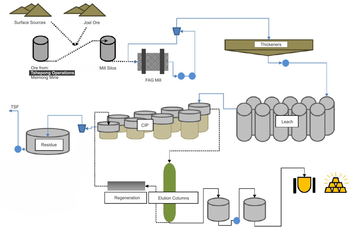
Effective Date: 30 June 2026
79
Technical Report Summary for
Tshepong North, Free State Province, South Africa
14.2Plant Throughput, Design, Equipment Characteristics and Specifications
The Harmony One Plant has a steady state design capacity of 390ktpm with its conventional CIP flowsheet.
The design parameters and equipment specifications are presented in Table 14 1. The Harmony One plant is
in good working condition and the equipment is also in good order with audits done on regular bases to
check the operating performance of the plant.
Table 14-1: Key Design Parameters and Equipment Specifications
Process | Parameter | Unit | Value |
Overall Plant | Recovery | % | 94 |
Availability | % | 100 | |
Milling | Throughput ROM | t/hr | 90 -100 |
Densification | Desired pH | pH | >10.5 |
Desired Density | g/cm3 | 1.45 - 1.50 | |
Leaching | Residence Time | hr | 27 |
Acid wash and elution | Elution Temperature | °C | 130 (Ambient) |
14.3Energy, Water, Process Material and Personnel Requirements
14.3.1Energy
The average monthly power consumption is 12,064,464KWh. (Available all the time although load
curtailment)
14.3.2Water
The average monthly water consumption is 20,655kL. (Available all the time)
14.3.3Process Material
The reagents and their consumption rates are presented in Table 14-2. All reagents above are currently being
utilized in the plant and are sourced in South Africa. Carbon is supplied from international suppliers to local
authorized vendors who manage in country stock levels according to commercial agreements.
Table 14-2: Harmony One Plant Consumables
Equipment | Unit | Value |
Lime | tpm | 882.00 |
Flocculant | tpm | 43.00 |
Cyanide | tpm | 9.89 |
Carbon | tpm | 789.00 |
14.3.4Personnel
The personnel is provided in Table 14-3.
Table 14-3: Harmony One Plant Personnel
Personnel | No. |
Services | 57 |
Engineering | 77 |
Metallurgy | 138 |
Contractors | 245 |
Total | 517 |
14.4Commentary on the Processing and Recovery Methods
The metallurgical process is a well-tested CIP technology which has been in operation at the Harmony One
plant since 1986. Recoveries used in the business plan were based on historic performance. The methodology
applied considered the historical metallurgical recovery (18-month period) (Figure 14-2) for the relevant ore
sources at the plant.
Effective Date: 30 June 2026
80
Technical Report Summary for
Tshepong North, Free State Province, South Africa
It should be noted that since the Harmony One plant processes ore from multiple sources a metal accounting
operating procedure is required to manage the input feed delivered to the plant and gold output produced. A
basic overview of the procedure is as follows:
•each operation delivers ore to the plant and is booked against each source;
•a delivery sheet reflects each shaft/operations figures; and
•from total ore processed, each shaft/operations equivalent proportion of gold is determined out of
the monthly full gold produced.
Figure 14-2: Graph of Historical Recovery Factor (18 month actual)
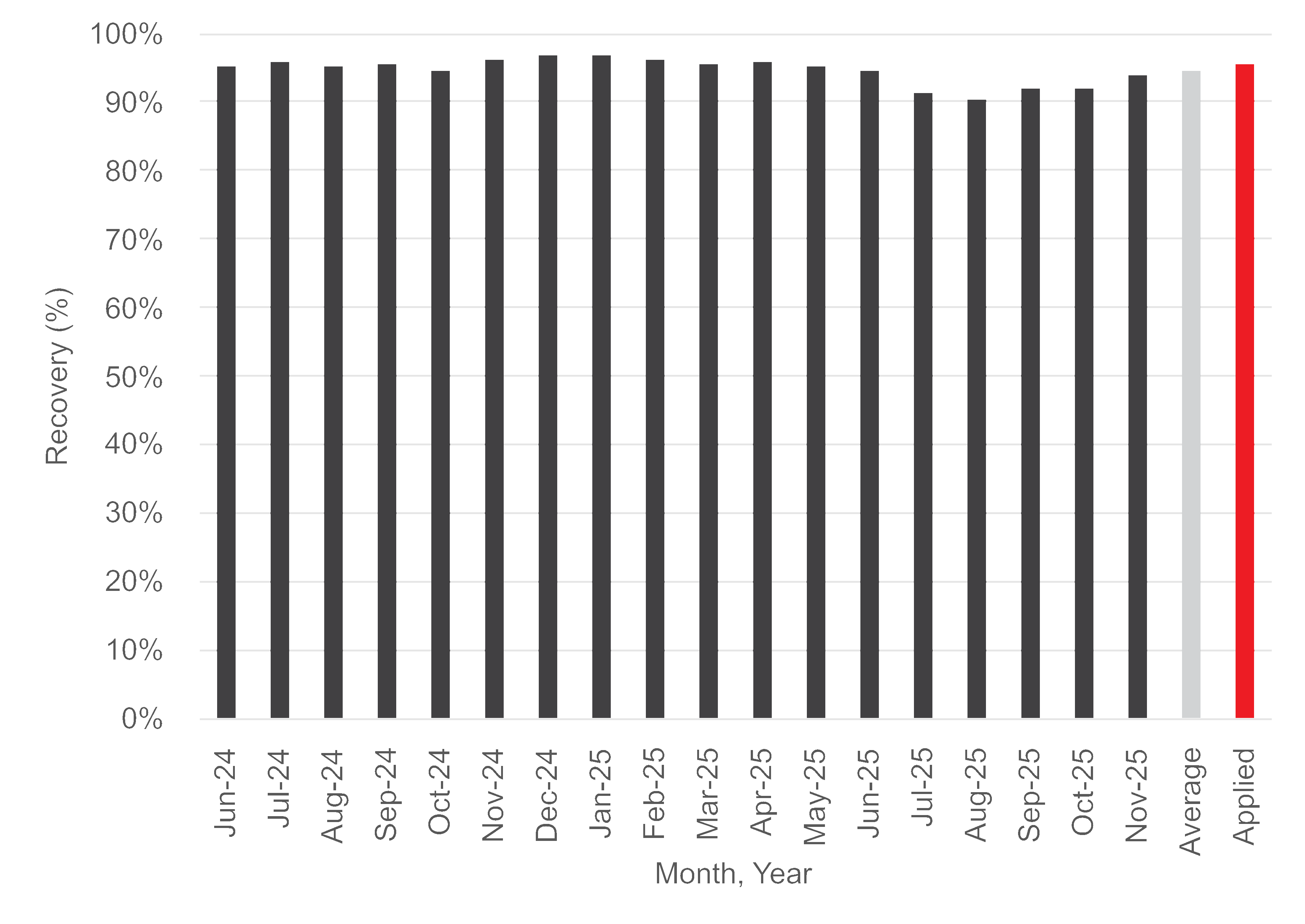
Effective Date: 30 June 2026
81
Technical Report Summary for
Tshepong North, Free State Province, South Africa
15Infrastructure
Section 229.601(b)(96)(iii)(B)(15)
The proximity of Tshepong North and South allows for the integration of infrastructural requirements by
using the excess hoisting capacity and underused infrastructure available at Tshepong North. This has also
enabled the debottlenecking of Tshepong South’s infrastructure. Tshepong North have adequate access to
the infrastructure required to meet the planned production schedules.
15.1Surface Infrastructure
The surface infrastructure associated with Tshepong North is presented in Figure 15-1, whilst Google Earth
images for each of the shafts and Harmony One Plant are presented in Figure 15-2, and Figure 15-3.
The Tshepong North’s mining area is well developed in terms of access and mining-related infrastructure.
Access to the shafts is via well-maintained roads. Adequately maintained gravel roads is used to access other
areas of the mine such as the explosives magazines, sewage works, slimes dam and the evaporation ponds.
The infrastructural layout includes hoisting facilities; logistical support for core handling, sampling, and
transporting; ore and waste facilities; tailings and leaching infrastructure; roads; water and power supply;
ventilation and refrigeration systems; stores and workshop support; electrical supply; offices; housing and
security.
15.1.1Ore and Waste Rock Storage Facilities
Ore mined at Tshepong North is stored in two surface silos each with a capacity of a 1000t on surface before
being transported by rail to the Harmony One Plant for processing (Figure 15-1 and Figure 15-3). Ore is stored
in silos located at the plant prior to processing.
Waste at the Tshepong North Mine is hoisted separately via the skips and stored at the waste rock dump
(577m x 320m) on the Northern side of the shaft. Sufficient storage is available for the current Life of Mine
profile, calculated at 95% of capacity to be used 2031 at planned production rate and design. Currently rock
from Tshepong North waste rock dump is being transported to Harmony One processing plant as grind
material at a rate of approximately 70kt /month.
15.1.2Tailings Storage Facilities
The current Mineral Reserve plans for Tshepong North require a tailings placement of approximately 0.77Mt/
annum. Harmony One Plant pumps tailings as slurry to two TSFs, namely FSS2 and St Helena No.4, located to
the south of the plant. Both TSFs are currently owned by Harmony and operated by Intasol Tailings.
The current TSF sites have the capacity to store 350,000tpm, with a split of 50,000tpm to FSS2 and 300,
000tpm to St. Helena 4.The current heights of the facilities are 44.83m for FSS2 and 38.17m for St Helena 4.
FSS2 and St Helena have sufficient available capacity for Harmony One Plant tailings deposition until
approximately 2029 and October 2030, respectively, based on projected maximum rates of rise of 0.674m/
year and 3.2m/year, which allow adequate time for consolidation. A project is currently underway to
determine the optimal long-term tailings deposition strategy for the Free State Operations, including the Free
State surface reclamation projects. It is the opinion of the QP that deposition capacity does not pose a risk to
the Tshepong North Mineral Reserves.
The TSFs are classified in accordance with the SANS 10286 classification system and are monitored by
internal engineers, with support from external engineering specialists, appointed as the Engineer of Record
(EoR) for the facilities. Annual slope stability assessments are conducted by Geotheta, in their capacity as
EoR, using available geotechnical parameters, piezometer measurements, and results of the annual CPTu
investigations. The latest results from the 2025 annual report show that the facility is considered stable in
normal operating conditions. An analysis of the downstream impact on communities, ecosystems, and critical
infrastructure in the event of catastrophic failure has been assessed as part of the SANS 10286 classification
system. There is also a long-term monitoring and closure plan in progress.
15.1.3Rail
A railway line which traverses the Tshepong North Mining Right area is used to transport hoisted ore to the
Harmony One Plant (Figure 15-1).
Effective Date: 30 June 2026
82
Technical Report Summary for
Tshepong North, Free State Province, South Africa
Figure 15-1: Tshepong North Surface Layout and Infrastructure
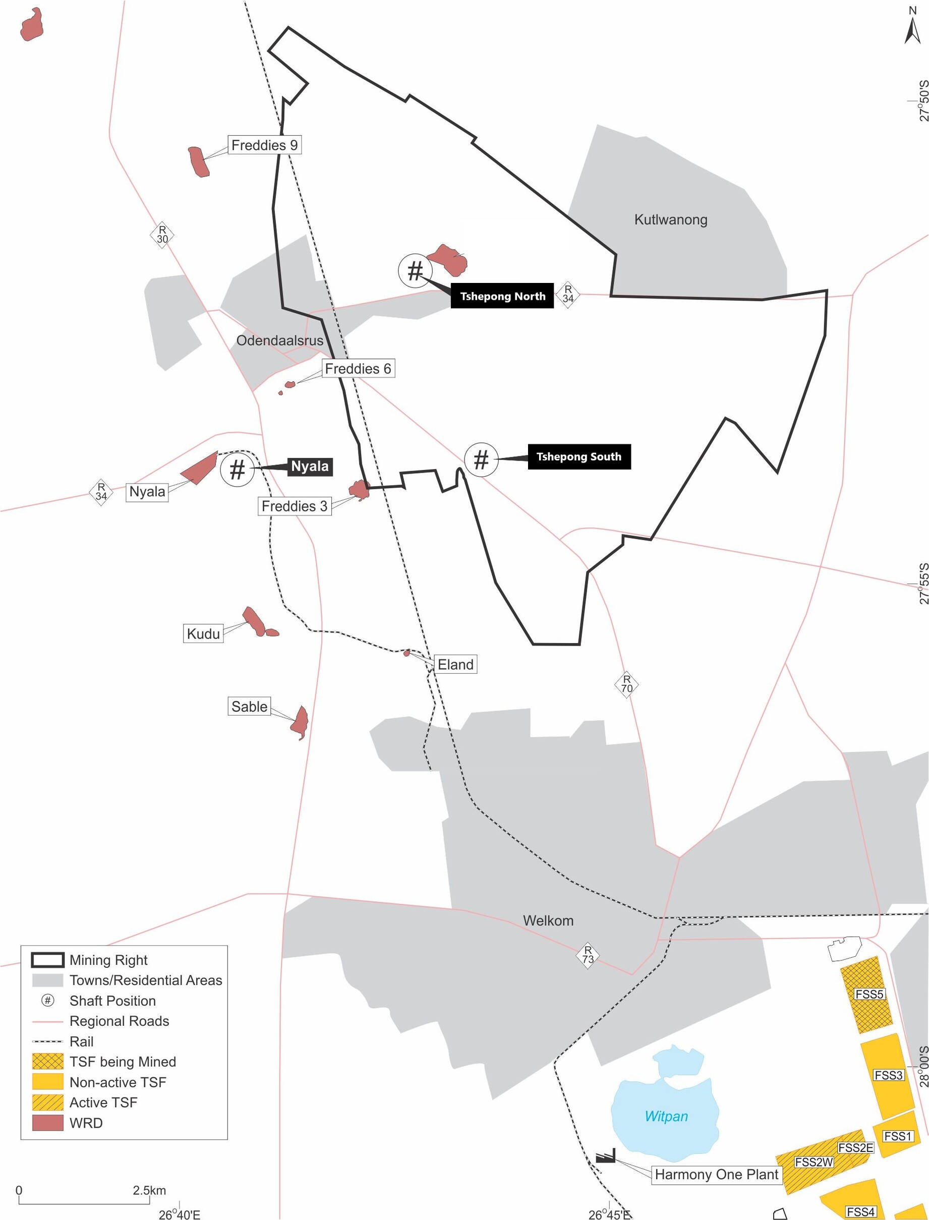
Effective Date: 30 June 2026
83
Technical Report Summary for
Tshepong North, Free State Province, South Africa
Figure 15-2: Tshepong North Detailed Surface Infrastructure
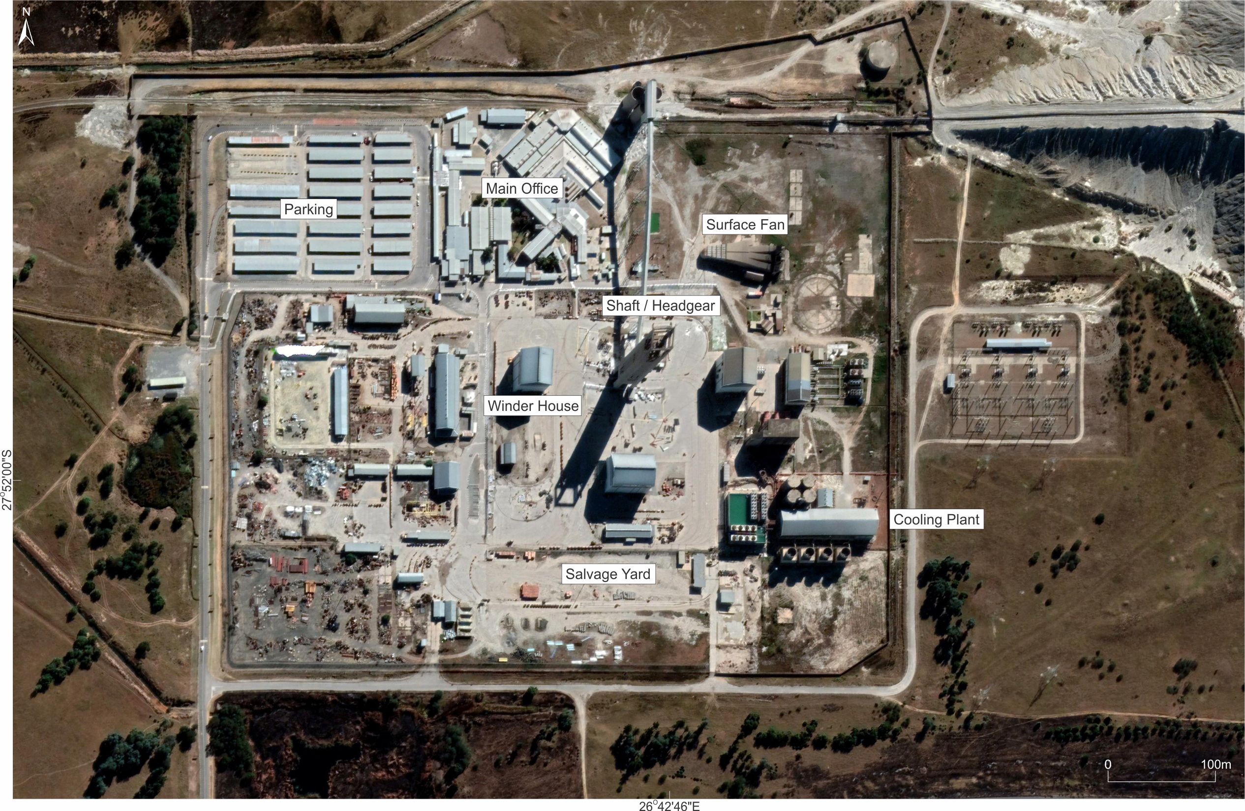
Effective Date: 30 June 2026
84
Technical Report Summary for
Tshepong North, Free State Province, South Africa
Figure 15-3: Harmony One Plant Detailed Surface Infrastructure
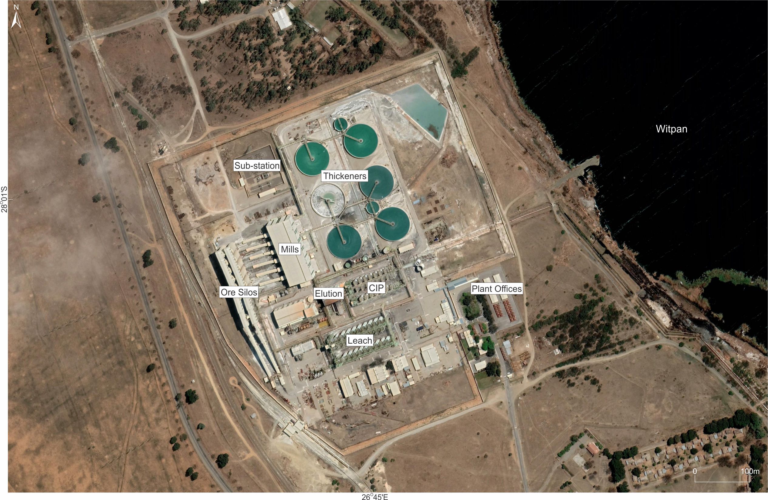
Source: Google Earth Image Date: September 202
Effective Date: 30 June 2026
85
Technical Report Summary for
Tshepong North, Free State Province, South Africa
15.2Underground Infrastructure and Shafts
The Tshepong North shaft complex and underground infrastructure are schematically depicted in Figure 13-6.
The underground workings are accessed via two vertical shafts and a decline shaft system. The Main Shaft is
utilised for the transport of personnel, materials and ore, while the Ventilation Shaft provides primary
ventilation services to the mine. The decline shaft provides supplementary access to the underground mining
areas.
At Tshepong North, the main vertical shaft system extends from surface to 71 level, at 2,161m below surface.
The ventilation shaft system extends to 2,148m below surface and the sub 66 decline shaft system extends
from 66 level to 77 level.
There are four refrigeration plants on surface, serving the Tshepong North Mine. Bulk air is supplied via the
Tshepong North shaft to an inter-level refrigeration system on 63 level, assisted by cooling cars and coils. Two
underground booster fans are installed and commissioned November 2023 on 66 Level, to increase the
return air capacity to the decline section.
15.3Power and Electrical
Power is supplied by Eskom. Tshepong North power supply is designed to satisfy the planned Mineral
Reserve production and service requirements. Main power supply is managed and distributed via electrical
sub-stations located adjacent to the respective shafts (Figure 15-2).
Power lines traverse the mine property to connect the shafts, reduction works and hostel complexes.
In addition, Tshepong North have a 10MW grid tied solar installation to reduce the energy usage. The
operation has sufficient electricity supply, with 80MW available from Eskom. Currently no ore processing is
undertaken at the shaft.
15.4Water Usage
Tshepong North has a closed loop water reticulation and cooling system where the water is re-used for
cooling, drilling, dust suppression, footwall and sidewall treatment. The local municipality supply potable
water to the mine for the use of surface equipment cooling make up water, drinking water and domestic
consumption on surface. A water storage dam, with capacity of +- 1 ML, is available on surface.
The storage facilities have sufficient water to supply water to the operation for up to 48 hours if the bulk
water supply was interrupted.
15.5Logistics and Supply
The procurement of supplies and equipment are handled centrally, via Harmony, and then delivered to
Tshepong North.
Harmony operates its own rail system which connects the shafts, reduction works, shaft stores, explosives
magazine and the mine workshops. This system is used to transport ore between shafts and to transport
consumables between the surface stores to the respective locations, as required. It is also connected to the
regional Transnet railway system, which transports ore to the Harmony One Plant. All capacities for the shaft
requirement to ensure optimum production as planned is provided for.
15.6Commentary on Infrastructure
The operational infrastructure including road, rail, offices, security services, refrigeration, compressors, pump
stations, chairlift, water and power supply is adequate to satisfy the Tshepong North Mineral Reserve plan.
Operations are powered by electricity from Eskom. Overall, Tshepong North is well-established with
sufficient logistical and infrastructure support for the existing and planned mining operations.
The “Property, Plant, and Equipment” as of June 30, 2026 including buildings and mine infrastructure, mining
assets, rehabilitation and assets under construction, had a carrying value of R4,008 million.
Effective Date: 30 June 2026
86
Technical Report Summary for
Tshepong North, Free State Province, South Africa
16Market Studies
Section 229.601(b)(96)(iii)(B)(16) (i-ii)
Gold is traded in a variety of markets/exchanges both in physical form through over the counter (“OTC”)
markets, bullion banks and metal exchanges etc., and through passive investments such as exchange traded
funds (“ETFs”), which are based on gold prices and units representing physical gold which may be in paper or
dematerialised form. Demand is driven by the jewellery market, bar and coin, use in technology, ETF’s and
other financial products, and by central banks. An overview of the gold market is given in the following
sections based mainly on data from the World Gold Council and GoldHub websites.
16.1Market Overview
Annual global gold demand (excl. over-the-counter demand (OTC) and other) experienced an increase of
8.0% on an annual basis, totalling to 4,999.4 tonnes in 2025 when compared to the 4,630.6 tonnes recorded
in 2024. The fourth quarter of 2025 recorded an average gold demand (excl. OTC and other) of 1,330.6
tonnes, supported by a combination of record bullion prices, which recorded 53 new all-time highs during
2025, and record high fourth quarter demand, with exchange-traded funds (ETF) inflows recording the
second strongest year, while bar and coin buying reached a 12-year high. Furthermore, moving into the first
quarter of 2026, global gold demand (excl. OTC and other) was recorded at 1,195.9 tonnes, significantly lower
when compared to the 1,330.6 tonnes recorded in the fourth quarter of 2025. However, when compared to
the first quarter of 2025, gold demand decreased by a substantial -9.0%. The main contributing factors to the
lower gold demand during the first quarter of 2026 include:
•Jewellery consumption decreased by a significant -31.0% when compared to the fourth quarter of
2025, whilst jewellery inventory recorded an annual decrease of -19.0% in the first quarter of 2026.
Furthermore, jewellery fabrication in the first quarter of 2026 was -24.0% lower when compared to
the previous quarter.
•Bar and coin demand in the first quarter of 2026 was 42.0% higher on an annual basis at 473.6 tonnes,
marking the second highest quarter on record; primarily driven by robust investment demand for gold
products from Asian investors. However, metals imitation coins decreased by a notable -34.0% on a
quarter-on-quarter basis when compared to the fourth quarter of 2025, while on an annual basis,
metals imitation coins increased by 23.0% in the first quarter of 2026 when compared to the same
quarter a year ago.
•ETFs and similar products demand decreased by a notable -65.0% when compared to the fourth
quarter of 2025. Furthermore, on an annual basis, a substantial decrease of -73.0% was recorded in
the first quarter of 2026.
•Central Banks and other institutions bought 243.7 tonnes of gold in the first quarter of 2026, recording
a significant increase of 17.0% when compared the fourth quarter of 2025. Furthermore, an annual
increase of 3.0% was recorded when compared to the 237.0 tonnes recorded a year ago.
In addition, the recent increases in total bullion demand and record high prices in the first quarter of 2026
were further supported by a slight increase in OTC demand.
16.2Global Production and Supply
Total gold supply was 1.0% higher in 2025 when compared to 2024, while the annual supply growth was 2.0%
higher in the first quarter of 2026 when compared to the first quarter of 2025. Gold production and supply
are sourced from existing mining operations, new mines and recycling.
Effective Date: 30 June 2026
87
Technical Report Summary for
Tshepong North, Free State Province, South Africa
16.2.1New Mine Production
Gold supply from mine production amounted to 3,671.6 tonnes in 2025, marginally higher when compared to
the 3,650.4 tonnes recorded in 2024. In the fourth quarter of 2025, mine production of gold decreased to
968.4 tonnes when compared to the 1,032.8 tonnes recorded in the previous quarter. However, moving into
the first quarter of 2026, mine production increased by 2.0% on a year-on-year basis to reach 884.7 tonnes,
while on a quarterly basis, mine production decreased by a notable -9.0%, primarily due to normal seasonal
fluctuations in the mining industry.
According to the WGC, preliminary data indicated notable increases in gold mine production in the first
quarter of 2026 for Mali (30.0% y-o-y); Indonesia (19.0% y-o-y); Canada (15.0% y-o-y); and Peru (3.0% y-o-y).
Based on data released by the United States Geological Survey (USGS), China remained the largest gold
producer in the world in 2025 (380.0t), followed by Russia (310.0t); Australia (280.0t); Canada (200.0t);
United States (160.0t); Ghana (150.0t); Mexico (140.0t); Kazakhstan (130.0t); Uzbekistan (130.0t); Peru
(110.0t); Indonesia (90.0t); and Brazil (80.0t). South Africa produced 90.0t in 2025; unchanged when
compared to the production levels recorded in 2024
Figure 16-1 World Gold Council: Mine Production - Major producing Gold Countries ranked by 2025
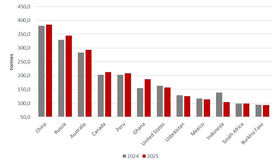
Source: ETSA & World Gold Council, 2026
16.2.2Recycling
The global annual supply of recycled gold increased by 3.0% in 2025 to reach 1,404.3 tonnes when compared
to 2024. The increase in supply was encouraged by higher bullion prices, resulting in a 2.0% increase in
recycled gold during the fourth quarter of 2025 when compared to the same quarter in 2024. This marked
the strongest quarterly performance in recycled gold supply since the third quarter of 2020. Notably, East
Asia recorded the most significant increase among all regions, primarily driven by volume increases in China.
Furthermore, global supply of recycled gold increased by 5.0% to reach 366.0 tonnes during the first quarter
of 2026, when compared to the 348.5 tonnes recorded during the same period in 2025, supported by
multiple record high bullion prices. However, on a quarterly basis, supply of recycled gold remained relatively
unchanged when compared to the previous quarter.
16.3Global Consumption and Demand
During the first quarter of 2026, gold demand (excl. OTC and other) reached 1,195.9 tonnes, reflecting a
decrease of -9.0% when compared to the same quarter the previous year. However, when including OTC and
other, total demand increased by 2.0% on an annual basis in the first quarter of 2026 to reach 1 230.9
tonnes; resulting in a record quarterly demand value of US$193.0 billion, amid gold’s outstanding price
increase.
Effective Date: 30 June 2026
88
Technical Report Summary for
Tshepong North, Free State Province, South Africa
16.3.1Jewellery
A total annual jewellery consumption of 1,542.3 tonnes was recorded by the World Gold Council (WGC) for
2025, reflecting a significant decrease of -18.0% and marking a five-year low when compared to the 1,886.9
tonnes recorded in 2024. The decline in global jewellery demand can mainly be ascribed to multiple record
high bullion prices recorded during 2025. Consequently, the value of jewellery demand increased to a record
high of US$172.0 billion. Furthermore, in the first quarter of 2026, total global jewellery fabrication demand
experienced a significant quarter-on-quarter decline of -24.0%, decreasing from 438.0 tonnes in the fourth
quarter of 2025 to 335.0 tonnes in the first quarter of 2026 and marking the lowest quarterly level since the
second quarter of 2020, during Covid. However, the value of total global jewellery demand increased to
reach a record high first quarter value of US$47.0 billion.
In China, demand for gold jewellery decreased by a notable -32.0% to reach 85.2 tonnes in the first quarter of
2026 when compared to the same quarter a year ago. Chinese demand was pressured amid record high gold
prices; weak income growth and consumer confidence; and the introduction of changes in the Value Added
Tax (VAT) treatment of gold jewellery in the fourth quarter of 2025. However, Chinese spending on gold
jewellery increased by 16.0% on a year-on-year basis to reach US$13.0 billion. In addition, demand from India
was pressured amid record high bullion prices; however, demand remained resilient and reached a record
high first quarter value of US$10.0 billion.
16.3.2Investment
Total annual gold investment increased by a significant 84.0% to reach 2,175.3 tonnes in 2025, higher when
compared to the 1,185.4 tonnes recorded in 2024 and exceeding the previous annual record held since 2020.
In addition, gold physically-backed exchange-traded funds (ETF) investments increased to reach a record high
of 4,025.0 tonnes in 2025, while bar and coin investment increased to a 12-year high value of US$154.0
billion during the same period. The increased investment in the safe-haven asset was primarily driven by
escalating geopolitical risks; a weaker US Dollar; expectations of lower interest rates; and extended stock
valuations.
However, in the first quarter of 2026, investment in gold (excluding OTC) recorded a decrease of -5.0% on a
year-on-year basis to reach 535.6 tonnes, down from the 563.6 tonnes recorded in the first quarter of 2025
and also lower when compared to the 602.9 tonnes recorded in the fourth quarter of 2025. ETF holdings
decreased significantly to 62.0 tonnes in the first quarter of 2026 from 229.9 tonnes recorded in the first
quarter of 2025, marking a notable decrease of -73.0%. ETF holdings were pressured as outflows during
March 2026 offset most of the inflows recorded during January 2026 and February 2026. However, ETF
holdings still recorded a seventh consecutive quarter of positive demand. Additionally, investment in gold
was pressured by profit-taking, deleveraging and liquidity-driven demand for gold amid broader risk-off
market conditions.
According to the WGC, global bar and coin investment increased by a notable 42.0% when compared to the
first quarter of 2025, to reach an average of 473.6 tonnes in the first three months of 2026.
The average London Bullion Market Association (LBMA) price of gold reached a record high quarterly average
to trade 70.0% higher in the first quarter of 2026 at US$4,872.90 an ounce, when compared to the same
period a year ago, which also represented an 18.0% quarter-on-quarter increase when compared to the
US$4,135.20 an ounce recorded during the fourth quarter of 2025.
Effective Date: 30 June 2026
89
Technical Report Summary for
Tshepong North, Free State Province, South Africa
Figure 16-2 World Gold Council: Total Gold Supply & Demand
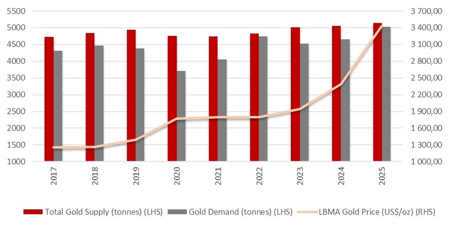
Source: ETSA & World Gold Council, 2026.
16.3.3The USD Currency and Gold
The inverse relationship between the value of the US Dollar (USD) and that of gold is one of the most
discussed relationships in currency markets. The USD is the internationally accepted currency and most of the
international transactions take place in USD equivalent. The major reason behind the relationship of gold and
the USD, is that gold is used as a hedge against the adverse exchange value of the USD. As the US Dollar’s
exchange value decreases, it requires more USD to buy gold, which increases the value of gold. Two other
factors linked to the strength of the USD are inflation and interest rates.
In 2026, leading central banks kept interest rates unchanged at their latest policy meetings, including the U.S.
Federal Reserve Bank; the Bank of England (BoE); the European Central Bank (ECB); and the South African
Reserve Bank (SARB), with the SARB maintaining the repurchase rate at 6.75%. The decision to maintain
interest rates can mainly be attributed to heightened uncertainty over global economic conditions and
inflation risks amid the Middle East conflict. However, several major central banks warned of possible future
interest rate hikes to prevent surging energy prices from leading to higher inflation, which could cause non-
yielding bullion to become less attractive and place downward pressure on gold prices.
The US Dollar is anticipated to remain steady over the next few months. Furthermore, movements in the US
Dollar are expected to remain dependent on developments in the Middle East war, with the currency
appreciating during times of escalated tensions and depreciating during periods of eased tensions. However,
over the long term, the US Dollar is expected to weaken as more investors seek diversification into European
currencies, particularly the Euro and British Pound.
16.4Gold Price
16.4.1Historical Gold Price
The LBMA gold price reached 53 new record highs during 2025 and recorded an annual average price of
US$3,431.50 an ounce in 2025, 44.0% higher when compared to an average of US$2,386.20 an ounce
recorded in 2024. The upward trajectory continued into the first quarter of 2026 where gold prices averaged
18.0% higher at US$4,872.90 an ounce on a quarter-on-quarter basis, reaching a new quarterly high. When
compared to the same quarter a year ago, gold prices increased by a considerable 70.0% in the first quarter
of 2026.
Moving into the second quarter of 2026, gold prices remained elevated in April 2026, recording a notable
5.6% year-to-date increase to trade at US$4,611.00 an ounce. Gold prices were supported by a weaker US
Dollar and strong ETF inflows; however, these gains were partly offset by improved risk appetite and lower
market volatility.
The geopolitical risk premium is expected to continue its upward trend and support gold prices, which could
in turn support stronger demand for gold ETFs and OTC, as well as bar and coin demand. However, higher
Effective Date: 30 June 2026
90
Technical Report Summary for
Tshepong North, Free State Province, South Africa
bullion prices are expected to weigh on jewellery demand, while mine production is expected to increase
modestly in 2026. The latest market expectations point to U.S. interest rates remaining within the 3.50% to
3.75% range until the end of 2026, with expectations of a first interest rate cut in December 2026, amid
higher inflation concerns driven by elevated energy prices due to the Iran war.
Figure 16-3: World Gold Council: Daily Gold Price (ZAR/oz & USD/oz)
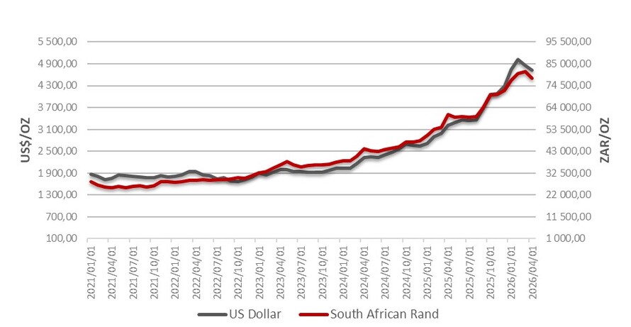
Source: World Gold Council, 2026.
16.4.2Forecast Gold Price
Consensus gold price range for the year 2026 to year 2028 is presented in Table 16.1. The long-term gold
prices are considered from year 2027 onwards by the QP. Forecasts as advised from various financial
institutions show that gold is expected to trade in a range of US$3,300/oz – US$5,000/oz, for the period 2026
to 2028 with a long-term outlook of US$2,915/oz.
Table 16-1 Consensus View of Forecast Gold Price US$/Oz
Institutions | 2026 | 2027 | 2028 |
World Bank: Development | 4,700 | 4,300 | — |
BMO Capital Markets | 5,000 | 4,700 | — |
Scotiabank | 4,500 | 4,050 | — |
Nedbank | 4,646 | 4,540 | 4,490 |
Fitch Solutions | 4,500 | 3,800 | 3,300 |
S&P Global | 4,747 | 4,752 | 4,427 |
Australian Government | 4,049 | 3,788 | — |
Average | 4,592 | 4,276 | 4,073 |
16.4.3Harmony Group Gold Hedging Policy
Harmony has a hedging policy which is managed and executed at Group treasury level on-behalf of its
operating entities. The key features of the hedging program are as follows:
•the policy provides for hedging (or forward selling) up to maximum percentages of expected
production for different future periods, on a rolling basis, as set out below:
◦Year 1, 30%
◦Year 2, 20%
◦Year 3, 10%
•the policy has no minimum quantity that should be hedged, and if an attractive margin above cost
cannot be achieved (i.e., in a low gold price environment) then no hedges are entered into;
Effective Date: 30 June 2026
91
Technical Report Summary for
Tshepong North, Free State Province, South Africa
•Harmony enters into ZAR-denominated gold hedges for its South African operations and USD-
denominated hedges for Hidden Valley mine in Papua New Guinea);
•Individual mines do not enter into hedges in their own name but delivers bullion to Rand Refinery for
refining on behalf of Harmony. Rand Refinery is one of the world’s largest single-site precious metals
refining and smelting complex in the world. Rand Refinery refine all of Harmony’s South African gold
production to at least 99.5% purity, and acting as agent, sells the gold on the daily spot London fixing
price and make payment to Harmony two days later;
•gains and losses realised from the hedging program are accounted for at Group level and the financial
benefit (or downside) is distributed amongst the operations proportional to their levels of gold sales;
•Harmony does its mine planning and financial forecasts based on the estimated future gold price
provided by an external source (ETSA), but its year-end actual financial results reflect the received
gold price inclusive of the impact of the hedging programme. Therefore individual mines receive a
combined hedged gold price for the hedged portion of its gold sales with the balance attracting the
spot price
16.5Commentary on Market Studies
The factors which affect the global gold market are well-documented as are the elements which influence the
daily gold price.The average London Bullion Market Association (LBMA) price of gold reached a record high
quarterly average to trade 70.0% higher in the first quarter of 2026 at US$4,872.90 an ounce, when
compared to the same period a year ago, which also represented an 18.0% quarter-on-quarter increase when
compared to the US$4,135.20 an ounce recorded during the fourth quarter of 2025.
16.6Material Contracts
As with all major businesses, Harmony and Tshepong North enters into a multitude of vendor agreements for
the provisions of supplies and services. These agreements are entered into on a competitive basis and
typically are of a medium-term duration all with clauses providing for periodic updating of pricing, annual (or
other) renewal or termination.
Harmony has contractual vendor agreements with various service providers and suppliers. The most
significant of these contracts currently in place to support Tshepong North are listed in Table 16-2.
All of the listed contracts are currently valid and in good standing. Terms, rates and charges of contracts are
considered consistent with industry norms. Contract management processes are in place and resourced so
that contracts re-tendered and/or renewed as they approach expiry.
Table 16-2: Material Contracts
Vendor Name | Nature of Service / Supply |
Axis Mining & Construction cc | Underground Support services |
Transnet Limited (t/a Spoornet) | Rail transportation of ore and waste |
Genflo Mine Vacuum Systems SA (Pty) Ltd | Shaft Bottom Cleaning at Nyala Shaft |
Bidvest Protea Coin (Pty) Ltd | Security services |
Lesedi Drilling & Mining Company (Pty) Limited | Underground diamond drilling at Tshepong North |
Timrite (Pty) Ltd | Underground support |
AECI (Pty) Limited | Explosives supply |
Accutrack | Ore Tracking System |
Effective Date: 30 June 2026
92
Technical Report Summary for
Tshepong North, Free State Province, South Africa
17Environmental Studies, Permitting and Plans, Negotiations, or Agreements
with Local Individuals or Groups
Section 229.601(b)(96)(iii)(B)(17) (i-vii)
The South African Government has an extensive legal framework within which mining, environmental and
social aspects of the industry are managed. Harmony and its Tshepong North Mine is primarily regulated and
managed by certain principal Acts (as listed in Section 17.3) as well as corporate policies, management
systems and certain industry-wide guidelines, including:
•Energy Efficiency and Climate Change Policy;
•Environmental Policy;
•Harmony Water Management Strategy;
•Biodiversity and Rehabilitation Position Statement;
•Socio-Economic Transformation Policy; and
•Corporate Social Responsibility Policy.
The latest sustainability policies and public environmental social and governance (“ESG”) performance and
disclosure report(s) are available on the corporate website. Harmony has identified the environmental risks
for the business and has strategies in place to manage the risks.
17.1Results of Environmental Studies
Tshepong North have prepared multiple environmental impact assessments (“EIA”) for regulatory approval,
which under the current legal framework, require stakeholder engagement. The results of the studies have
been incorporated into the Harmony business planning process. The results of all the studies are too
voluminous to include in this TRS and therefore the reader is directed to EMP PAR (Environmental
Management Program Performance Assessment) Harmony Tshepong North, Matjhabeng and
ARM(Reference Number FS 30/5/1/2/2/84MR).
Harmony is committed to maintaining good relationships with regulatory authorities, industries,
communities, business partners and surrounding stakeholders.
17.2Waste and Tailings Disposal, Monitoring & Water Management
The process of mining and beneficiation produce significant waste, typically consisting of 1) solid waste in the
form of waste rock and overburden, 2) liquid wastes in the form of wastewater and tailings slurry and 3)
gaseous emissions such as liquefied petroleum gas.
Measures have been put in place for the handling and disposal of all hazardous chemicals (e.g., cyanide),
hydrocarbons (i.e., hydraulic oils and diesel) and other chemicals to ensure the protection of human health
and its potential impact on the environment.
Harmony recognizes that responsible and effective waste management can positively reduce its
environmental impacts and mitigate associated environmental liabilities. Waste management is thus a
priority focus area. Internally, guidelines on mineral, non-mineral and hazardous waste materials are included
in the environmental management systems (“EMS”) implemented at Tshepong North.
Tailings comprises of crushed rock and process water emitted from the gold elution process in the form of
slurry once gold has been extracted. As tailings contain impurities and pollutants, they are placed in TSF
engineered to contain them, in line with Harmony's tailings management program and the Global Industry
Standard on Tailings Management (“GISTM”).
Effective Date: 30 June 2026
93
Technical Report Summary for
Tshepong North, Free State Province, South Africa
Harmony's overall tailings management strategy is to ensure robust, meticulous engineering and dam design,
along with a continual focus on management of risks through layered assurance and oversight. The focus
areas include, but are not limited to:
•freeboard control;
•water management;
•maintaining stability and the safety factor as advised by the engineer of record;
•erosion controls; and
•monitoring and control measures implemented to ensure continued compliance (including regular
inspections, audits, and meetings on varying intervals with subsequent actions, minutes and reports).
As part of its mining, environmental and water approvals and licenses, Harmony is required to implement
monitoring programs and plans to establish the operations impact on the environment. The compliance limits
for the monitoring variable are included in the applicable EMPR(s), WULA(s) and environmental
authorizations. The environmental monitoring implemented at Tshepong North includes:
•ground and surface water monitoring
•biodiversity monitoring;
•waste classification and quantification;
•integrated waste and water management plan (“IWWMP”) updates;
•water balance reviews;
•license and authorization compliance reviews; and
•air quality (i.e., noise and dust) and greenhouse gas emissions ("GHG") monitoring.
Harmony One Plant pumps tailings as slurry to two TSFs, namely FSS2 and St Helena No.4, located to the
south of the plant. All TSFs are currently owned and operated by Harmony.
The current TSF sites have the capacity to store 350,000tpm, with a split of 50,000tpm to FSS2 and 300,
000tpm to St. Helena 4.
17.3Permitting and Licenses
In respect of environment, the following national Acts and the regulations promulgated thereunder provide
the regulatory framework for mine permitting and licensing in South Africa:
•Mineral and Petroleum Resources Development Act, 2002 (“MPRDA”);
•National Environmental Management Act, 1998 (“NEMA”);
•National Environmental Management: Waste Act, 2008 (“NEM:WA”);
•National Environmental Management: Air Quality Act, 2004 (“NEM:AQA”); and
•National Water Act, 1998 (“NWA”).
A summary of the status of environmental permits and licenses issued at the effective date related to
Tshepong North is presented in Table 17-1.
All relevant mining, environmental and water-use permits are in place that cover the environmental,
archaeological, and hydrological components of the Tshepong North Operation. All permits are audited
regularly for compliance and no material risks to the operations have been identified.
Effective Date: 30 June 2026
94
Technical Report Summary for
Tshepong North, Free State Province, South Africa
Table 17-1: Status of Environmental Permits and Licenses
Permit / License | Reference No. | Issued By | Date Granted | Validity |
Environmental Management Programme | FS 30/5/1/2/3/2/1(84)EM | DMPR | December 11, 2007 | December 10, 2029 |
Water Permit 936B. Harmony. Free State Geduld Mines. Discharge of untreated effluents | B33/2/340/31 | DWS | April 2, 1981 | LOM |
Water Permit 870B. Harmony. Discharge of untreated effluents. | B33/2/340/25 | DWS | May 27, 1991 | LOM |
Water Permit 1214N. Free State Consolidated Gold Mine. Tshepong, Freddie’s and Phakisa shafts. | B33/2/340/12 | DWS | Not indicated. | LOM |
Water Permit 1214N. Free State Consolidated Gold Mine. Tshepong, Freddie’s and Phakisa shafts. | B33/2/340/12 | DWS | Not indicated. | LOM |
Notes:DWS - Department of Water and Sanitation Affairs.
17.4Local Stakeholder Plans and Agreements
Harmony strives to create sustainable shared value within the communities it operates. Local stakeholder
plans and agreements are based on the results from socio-economic information, government development
strategies and EIAs undertaken. The socio-economic development program commits to:
•contribute to areas that will have the most meaningful socioeconomic impact on communities, namely
infrastructure, education and skills development, job creation and entrepreneurial development;
•enhance broad-based local and community economic empowerment and enterprise development
initiatives;
•facilitate socio-economic development in local communities by means of social and labour plan(s)
(“SLP”) and corporate social responsibility programs;
•support arts, culture, and sports and recreation; and
•build relationships based on trust within host communities.
In South Africa, mining companies are required to have a SLP, which forms an important component of
Harmony's community investment plan. It sets out the Company’s obligation to develop and implement
comprehensive human resource development programs, community development plans, housing and living
condition plans and employment equity plans. The aim of the SLP is to ensure the uplift of the social and
economic circumstances of local communities surrounding the mine. The SLP is a prerequisite to securing and
maintaining a mining right, with progress required to be reported annually.
17.5Mine Closure Plans
Harmony makes provision for closure and rehabilitation both for accounting purposes and as required under
the MPRDA. The statutory obligation for all environmental rehabilitation at Tshepong North is administered
by the DMPR and requires the preparation of a closure plan, the development of a cost estimate, and
financial assurance. The Company makes an annual submission to the DMPR setting out the cost of closure in
accordance with the MPRDA and the regulations issued thereunder.
Harmony appointed Digby Wells and Associates (South Africa) (Pty) Ltd, independent environmental
consultants, to review and update the Closure Cost Assessment for unscheduled closure associated with the
Tshepong North and Matjhabeng Mining Operations. The Matjhabeng Mining Operations is a Harmony
operation, located north of the town of Welkom in the Free State Province. The mine closure assessment was
done in terms of regulation 53 and 54 of the MPRDA and in accordance with the requirements of NEMA. The
closure cost as at 30 June 2026 was calculated to be approximately ZAR550.9m.
Harmony has made funding available in an amount equal to the cost of closure as determined under the
MPRDA in the form of a trust fund and/or bank guarantees.
Effective Date: 30 June 2026
95
Technical Report Summary for
Tshepong North, Free State Province, South Africa
Table 17-2: Mine Closure Liability
Area | Total Closure Cost (ZAR) |
Western Holdings 5 Shaft | R11,192,698 |
Eland Shaft and Freddies 6 | R19,459,481 |
Nyala Shaft | R88,394,451 |
Tailings Dams - North | R332,265,102 |
Tshepong South (Phakisa) | R22,625,202 |
Tshepong North | R46,969,482 |
Sable Shaft | R6,364,800 |
Kudu Shaft | R9,641,039 |
Sewage Treatment Plant | R5,699,864 |
Floatation Plant | R8,263,062 |
Grand Total | R550,875,181 |
Table 17-3: Rehabilitation Assurance
Area | Trust Fund (ZAR) | Bank Guarantee (ZAR) | Total (ZAR) |
Tshepong North and Matjhabeng Operation | 1,569,773,993 | — | 1,569,773,993 |
Tshepong South (Phakisa) | Included in above | ||
Total | 1,569,773,993 | — | 1,569,773,993 |
17.6Status of Issues Related to Environmental Compliance, Permitting, and Local Individuals or
Groups
All material mineral rights, mining rights, surface rights, environmental authorizations, permits, licenses, and
other governmental approvals required for current operations and the LOM Extension Project have been
obtained and are in good standing, or are expected to be renewed or maintained in the ordinary course of
business. Harmony has valid title to, or the right to acquire title to, the mineral and surface rights necessary
to conduct its operations. To the best of the Qualified Person's knowledge, there are no pending or
threatened legal, administrative, or regulatory proceedings that could materially impair Tshepong North’s
mineral tenure, mineral rights, surface rights, or mining operations. Furthermore, there are no known
conditions, obligations, timing constraints, or consequences related to permitting, tenure, regulatory
compliance, or third-party agreements that are reasonably likely to have a material adverse effect on
continued operations, the declaration of Mineral Reserves, or the implementation of the LOM Extension
Project.
17.7Local Procurement and Hiring
Harmony is committed to investing in the future of local communities beyond the mine closure and not to
only empower them, but also to mitigate the impacts its activities to ensure a positive legacy. The 2014
Mining Charter serves to guide the south African mining industry in socio-economic transformation. Local
procurement (goods and services) and human resource management are key measures set under the Mining
Charter and are reported on annually.
Portable skills are developed internally as well as through expanded learning programs, learnerships and
other programs opened only to operating communities. Local procurement is being supported where there is
a skills shortage. Some of the portable skills training offered to its employees include but not limited to basic
plumbing, electrical appliance repair, welding, catering and baking, sewing and clothing manufacturing.
17.8Commentary on Environmental Studies, Permitting and Plans, Negotiations, or Agreements
with Local Individuals or Groups
Periodic inspections are conducted by the DMPR to verify compliance with applicable environmental laws,
regulations, permits and standards. In addition, Tshepong North has implemented an EMS in line with the ISO
Effective Date: 30 June 2026
96
Technical Report Summary for
Tshepong North, Free State Province, South Africa
14001 standard. The EMS is audited on an annual basis by a third party and includes the needs and
expectations of interested parties.
As part of Harmony, Tshepong North conducts its operation based on policies and systems that are aligned to
its corporate sustainable development framework. Although Harmony is not a signatory to the International
Council on Mining and Metals or the UN Global Compact, these form the guiding principles of the framework.
Harmony discloses its sustainable development voluntarily in accordance with the guidelines issued by the
Global Reporting Initiative (“GRI”). Further to this, Harmony discloses environmental information on the
Carbon Disclosure Project (“CDP”) for both climate change and water. The CDP runs the global environmental
disclosure system that supports companies to measure and manage their risks and opportunities on climate
change, water security and deforestation.
Harmony has a good understanding of the environmental and social aspects of the operations through
baseline and specialist studies previously conducted. Risk management and mitigation measures were
adequately addressed in the environmental management plans and will be effective to mitigate risks and
impacts to acceptable levels should the measures be implemented according to the specialists’
recommendations.
The QP is of the opinion that most of the required environmental authorizations are in place and only require
amendments to be made to reflect the current infrastructure. Based on current industry norms, a realistic
timeframe to obtain relevant authorizations is estimated between 12 and 18 months.
Effective Date: 30 June 2026
97
Technical Report Summary for
Tshepong North, Free State Province, South Africa
18Capital and Operating Costs
Section 229.601(b)(96)(iii)(B)(18) (i-ii)
Economic parameters for the Harmony Group, including capital and operating costs, are determined, and
signed off by the CODM, before distribution to the business units, including Tshepong North. The capital and
operating costs are reported in ZAR terms and on a real basis. Rounding of figures may result in minor
computational discrepancies.
18.1Capital Costs
The estimated capital costs for the on-going Reserve plan at Tshepong North (including the LOM Extension
Project) are reported according to costs associated with major equipment outside the main operating
sections (“AE”), shaft projects and major projects as presented in Table 18-1. The estimated capital costs
presented in Table 18-1 are carried forward and modelled in the Tshepong North cash flow.
The estimated capital costs for the LOM Extension Project are broken down into project capital and MCC and
are provided in Table 18-1. The capital costs have been derived from the LOM Extension Project Feasibility
Study. The Harmony project capital cost estimate was compiled at an industry standard for Feasibility Studies
at a ±10%, level accuracy. A contingency of 5% has been applied to these capital costs.
18.2Operating Costs
A summary of the direct and indirect operating costs for Tshepong North for the 2026 Mineral Reserves are
presented in Table 18-2. The operating costs are based on historic performance while applying any changes
expected within the new financial year (such as electricity requirements, increased/decreased labour) and
are used as an input into the Tshepong North cash flow model. Costs are calculated at current prices with a
6% inflationary increase applied only in Year 1 to an accuracy level of ±5%. Contingencies are applied solely to
capital costs and not to working costs. Operating costs may be impacted by production overachievement,
potentially resulting in higher incentive payments and increased material cost due to usage.
18.3Comment on Capital and Operating Costs
The capital and operating cost estimates for Tshepong North are based on actual historical data, as well as
budget forecasts with a 5% contingency for the LOM Extension Project capital. Therefore, the forecasted
costs are reliable, and at minimum meet the confidence levels of a Feasibility Study. This approach of
estimating capital and operating costs is consistent with industry practice. A record of the forecast and
budget costs is maintained by the operation, allowing for an assessment of the alignment of the forecast and
actual costs.
The capital and operating costs for the LOM Extension Project are derived from a Feasibility Study and are
considered to have levels of accuracy in line with Feasibility Study requirements. Further, these estimates are
informed by the extensive operating history of Tshepong North which is, in most cases, directly applicable to
the LOM Extension Project.
Table 18-1: Summary of Capital Cost Estimate for Tshepong North
Capital Cost Element (ZAR'000) | Mineral Reserves (FY2027- FY2041) |
AE | 1,101,191 |
Shaft Projects | 1,125,856 |
Major Projects | 2,342,188 |
OCD | 5,203,977 |
Total (excluding MCC) | 9,773,212 |
MCC (LEDs/housing etc) | 375,561 |
Total (including MCC) | 10,148,773 |
Effective Date: 30 June 2026
98
Technical Report Summary for
Tshepong North, Free State Province, South Africa
Table 18-2: Summary of Operating Cost Estimate for Tshepong North
Operating Cost Element (ZAR'000) | Mineral Reserves (FY2027 - FY2041) |
Wages - Payroll 1 | 9,316,444 |
Wages - Payroll 2 | 14,859,316 |
Stores and Materials | 8,431,663 |
Electric Power and Water | 10,638,300 |
Outside Contractors | 3,478,335 |
Other | 3,013,543 |
Direct Costs | 49,737,602 |
Pumping allocation | 1,053,308 |
Refining charge allocation | 89,380 |
Assay cost allocation | 174,906 |
Hostel cost allocation | -395,895 |
Treatment cost allocation | 2,226,636 |
Rail transport allocation | 131,098 |
Working Cost Transfer To Capital | -174,997 |
Sampling Cost Allocation | -174,996,655 |
Re-allocated Costs | 3,104,436 |
Mine Overheads Re-allocated | 2,950,133 |
Total Cash Costs | 55,792,171 |
Effective Date: 30 June 2026
99
Technical Report Summary for
Tshepong North, Free State Province, South Africa
19Economic Analysis
Section 229.601(b)(96)(iii)(B)(19) (i-iv)
19.1Key Economic Assumptions and Parameters
The CODM formulate, review, signs-off and distributes economic assumptions to the various business units.
On an annual basis, during the period October to November, long-term commodity prices and exchange rate
forecasts are received from various financial institutions. In addition, a specialist in economics from a
reputable economics company based in South Africa provides expert views on the global markets, forward-
looking commodity prices, exchange rates, consumer price index, production price index, electricity cost and
consumable cost increases. All relevant factors are evaluated, taking cognisance of the requirements of the
NYSE and JSE markets, and a proposal is presented to the CODM for review and approval. Once approved,
these assumptions are communicated to the Company's business units and applied in conjunction with
operation-specific considerations. The QP reviewed and assessed the assumptions developed and approved
through the Company's governance process and concluded that they are reasonable and appropriate for use
in the Mineral Resource and Mineral Reserve estimates.
19.1.1Gold Price
The forecast gold price (US$2,915/oz) is the price that is used by Harmony for the annual planning cycle and
forms the basis for the spot gold price assumptions used in the cashflow. The reader is referred to Table 16-1
for the consensus forecast gold price. The conversions used in the calculation of the various gold prices are
presented in Table 19-1.
Table 19-1: Conversions Used in Gold Price Calculations
Economic Factors | Gold Price (US$/oz) | Conversion Factor (oz/kg) | Exchange Rate (ZAR:USD) | Gold Price (ZAR/kg) |
2026 Mineral Resource | 3,061 | 32.15 | 17.60 | 1,730,000 |
2026 Mineral Reserve | 2,915 | 32.15 | 17.60 | 1,650,000 |
19.1.2Exchange Rate
The South African Rand (ZAR) appreciated to average at R16.34/US$ during the first quarter of 2026, 4.6%
stronger when compared to an average of R17.12/US$ recorded during the last quarter of 2025. Moving onto
April 2026, the ZAR appreciated by 1.2% on a month-on-month basis, and by a notable 12.6% compared to
April 2025 to average at R16.54/US$, following an 8.4% annual appreciation recorded in March 2026.
More recently, the South African Rand appreciated against the US Dollar, driven by market anticipation
regarding an upcoming meeting in Beijing between U.S. President Donald Trump and China’s President, Xi
Jinping. On the 13th of May 2026, the commodity-backed currency strengthened by 0.4% to trade at R16.45/
US$, supported by expectations that China could help pressure Iran to reopen the Strait of Hormuz, which
could ease oil prices and inflation concerns.
However, the South African Rand depreciated to trade at R16.76/US$ on the 19th of May 2026, as investors
remained cautious over developments in the Middle East war after U.S. President Donald Trump paused a
planned attack on Iran to allow time for negotiations in order to end the war.
Effective Date: 30 June 2026
100
Technical Report Summary for
Tshepong North, Free State Province, South Africa
Figure 19-1: Annual Calendar Year Exchange Rates and ETSA Forecast
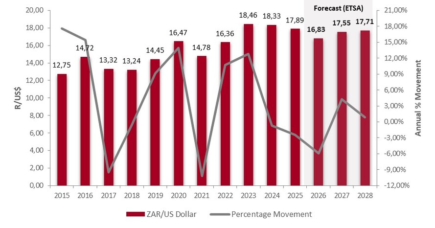
Source: SARB & ETSA Calculations, 2026
Table 19-2: Consensus View of Forecast Exchange Rate (ZAR:USD)
Institutions | 2026 | 2027 | 2028 |
Nedbank | 16.60 | 16.40 | 16.40 |
Investec | 16.29 | 15.81 | 15.85 |
FNB | 16.90 | 17.90 | 18.80 |
IDC | 16.64 | 16.87 | 17.01 |
AVERAGE | 16.61 | 16.75 | 17.02 |
Note: Figures reflect the latest available forecasts from institutions as at May 2026
The exchange rate of 17.60 ZAR:USD is the exchange rate that is used by Harmony for the annual planning
cycle and forms the basis for the ZAR:USD exchange rate in the company LOM and Mineral Reserve cashflow.
Table 19-3: ZAR:USD Exchange Rate Performance (June 2023 – June 2026)
Period | Average Exchange Rate (ZAR:USD) |
July 2023 to June 2024 | 18.70 |
July 2024 to June 2025 | 18.15 |
July 2025 to June 2026 | 16.89 |
3-Year Ave. (not weighted) | 17.91 |
Effective Date: 30 June 2026
101
Technical Report Summary for
Tshepong North, Free State Province, South Africa
19.1.3Royalties
Royalty is an expense paid to the government of South Africa and is accounted for in the cash flow models. In
terms of the mining ring-fencing application, each ring-fenced mine is treated separately, and deductions can
normally only be utilised against mining income generated from the relevant ring-fenced mine.
19.1.4Taxes
Mining tax on gold mining taxable income in South Africa is determined according to a formula, based on the
taxable income from mining operations. Of that, 5% of total revenue is exempt from taxation while the
remainder is taxable at a higher rate (33%) than non-mining income (27%). Accounting depreciation is
eliminated when calculating the South African mining tax income. Excess capital expenditure is carried
forward as unredeemed capital to be claimed against future mining taxable income.
19.1.5Summary
The key assumptions used in the cash flow are summarized for Tshepong North in Table 19-3.
Table 19-4: Key Economic Assumptions and Parameters for Tshepong North Cash Flow
Parameter | Unit | Value |
Production Rate | tpm | 58,698 |
Gold Recovery | % | 95.60 |
Royalty | % | Formula |
Tax Rate | % | Formula |
Gold Price | ZAR/kg | 1,650,000 |
Exchange Rate | USD:ZAR | 17.60 |
Discount Rate | % | 9.00 |
Effective Date: 30 June 2026
102
Technical Report Summary for
Tshepong North, Free State Province, South Africa
19.2Economic Analysis
Harmony's respective business units and its associated operating sites consider the economic assumptions
discussed in Section 19.1 during their respective planning and analysis processes. The past year’s average
gold price is used for testing purposes. A gold price of ZAR1,650,000/kg is used for forecasting the revenue of
the Tshepong North Mineral Reserve cash flow (Table 19-4).
The discounted cash flow model is used to calculate the Net Present Value (“NPV”) of the Mineral Reserve.
The NPV for the spot metal price, for Tshepong North LOM is approximately ZAR6,356 million cash positive, at a
discount rate of 9% (Table 19-5).
The NPV is calculated on a cash flow that accounts for factors such as:
•mining and ore processing working costs;
•royalty payments;
•capital costs, including costs allocated to ongoing development;
•any significant project work considered as major projects; and
•costs deemed as abnormal expenditure.
An IRR and payback period have not been calculated for Tshepong North because the LOM cash flow model
does not include any negative cash flows. Therefore, these measures are not meaningful for Tshepong North
economic analysis.
Effective Date: 30 June 2026
103
Technical Report Summary for
Tshepong North, Free State Province, South Africa
Table 19-5: Tshepong North Cash Flow
Item | Units | Total Reserve Plan | FY2027 | FY2028 | FY2029 | FY2030 | FY2031 | FY2032 | FY2033 |
Milled Tonnes | t '000 | 10,566 | 704 | 748 | 774 | 734 | 788 | 812 | 811 |
Yield | g/t | 4.85 | 4.74 | 4.54 | 4.60 | 4.71 | 4.65 | 4.23 | 4.19 |
Gold Recovered | kg | 51,242 | 3,341 | 3,393 | 3,558 | 3,456 | 3,665 | 3,431 | 3,402 |
Gold Price | R/kg | 1,650,000 | 1,650,000 | 1,650,000 | 1,650,000 | 1,650,000 | 1,650,000 | 1,650,000 | 1,650,000 |
Revenue | ZAR'000 | 84,549,514 | 5,512,867 | 5,598,290 | 5,871,086 | 5,701,838 | 6,047,195 | 5,661,167 | 5,612,619 |
Total Operating cost | ZAR'000 | 57,238,035 | 3,764,556 | 3,818,793 | 3,846,742 | 3,777,047 | 3,877,388 | 3,960,532 | 3,993,521 |
Total Capital including MCC | ZAR'000 | 10,148,773 | 1,115,115 | 1,227,553 | 1,098,089 | 1,095,983 | 856,303 | 904,276 | 686,105 |
Royalty | ZAR'000 | 422,748 | 27,564 | 27,991 | 29,355 | 28,509 | 30,236 | 28,306 | 28,063 |
Total Cost | ZAR'000 | 67,809,556 | 4,907,235 | 5,074,338 | 4,974,186 | 4,901,539 | 4,763,926 | 4,893,114 | 4,707,690 |
Cash flow before tax | ZAR'000 | 16,739,958 | 605,631 | 523,952 | 896,900 | 800,299 | 1,283,269 | 768,053 | 904,930 |
Taxation Payable | ZAR'000 | (4,129,119) | (108,896) | (80,532) | (199,104) | (170,018) | (323,700) | (160,048) | (206,019) |
Net cash flow after tax | ZAR'000 | 12,610,839 | 496,735 | 443,419 | 697,796 | 630,281 | 959,569 | 608,005 | 698,911 |
Effective Date: 30 June 2026
104
Technical Report Summary for
Tshepong North, Free State Province, South Africa
Item | Units | FY2034 | FY2035 | FY2036 | FY2037 | FY2038 | FY2039 | FY2040 | FY2041 |
Milled Tonnes | t '000 | 775 | 784 | 766 | 730 | 665 | 552 | 468 | 455 |
Yield | g/t | 4.66 | 4.98 | 5.09 | 5.53 | 5.50 | 4.99 | 5.68 | 5.45 |
Gold Recovered | kg | 3,608 | 3,905 | 3,897 | 4,041 | 3,656 | 2,755 | 2,655 | 2,480 |
Gold Price | R/kg | 1,650,000 | 1,650,000 | 1,650,000 | 1,650,000 | 1,650,000 | 1,650,000 | 1,650,000 | 1,650,000 |
Revenue | ZAR'000 | 5,953,027 | 6,443,659 | 6,430,386 | 6,668,182 | 6,032,399 | 4,545,219 | 4,380,352 | 4,091,229 |
Total Operating cost | ZAR'000 | 3,999,997 | 4,058,280 | 4,067,397 | 4,078,283 | 3,886,842 | 3,555,942 | 3,287,805 | 3,264,910 |
Total Capital including MCC | ZAR'000 | 684,225 | 658,425 | 531,623 | 433,773 | 370,482 | 286,123 | 184,193 | 16,505 |
Royalty | ZAR'000 | 29,765 | 32,218 | 32,152 | 33,341 | 30,162 | 22,726 | 21,902 | 20,456 |
Total Cost | ZAR'000 | 4,713,988 | 4,748,923 | 4,631,172 | 4,545,397 | 4,287,486 | 3,864,791 | 3,493,900 | 3,301,871 |
Cash flow before tax | ZAR'000 | 1,239,039 | 1,694,737 | 1,799,214 | 2,122,785 | 1,744,913 | 680,428 | 886,452 | 789,358 |
Taxation Payable | ZAR'000 | (310,658) | (452,943) | (487,639) | (590,494) | (476,287) | (149,545) | (220,253) | (192,983) |
Net cash flow after tax | ZAR'000 | 928,381 | 1,241,794 | 1,311,575 | 1,532,291 | 1,268,626 | 530,883 | 666,198 | 596,375 |
Discounted cash flow (ZAR'000) | Rate | After tax NPV | |||||||
NPV - Harmony preferred) | @9% | 6,355,591 | |||||||
NPV - (medium discount rate) | @12% | 5,241,020 | |||||||
NPV - (high discount rate) | @15% | 4,389,973 |
Effective Date: 30 June 2026
105
Technical Report Summary for
Tshepong North, Free State Province, South Africa
19.3Sensitivity Analysis
The economic assumptions, cash flow breakdown and economic analysis contribute to the basis for the
sensitivity analysis. The sensitivities are calculated and analysed, as shown in the accompanying Table 19-6,
Table 19-7 and Table 19-8.
Harmony has reviewed its exposure in terms of South Africa’s political instability, the COVID-19 pandemic,
the currency exchange rate, and the gold price, on its financial assets and financial liabilities, and has
determined the sensitivities for a ±10% variance. Management considers this range to be a reasonable
change given the volatility in the market.
The sensitivity analysis (Tables 19-6 to 19-8) is based on a change in a single assumption while holding all
other assumptions constant. In practice, this is unlikely to occur, as risks and/or opportunities will have an
impact on the cash flows, and changes in some of these assumptions may be correlated. The sensitivity
analysis indicates that Tshepong North is almost equally sensitive to the gold price (ZAR/kg), as to changes in
total operating costs (ZAR).
The impact of one or a combination of risks and opportunities occurring at the same time cannot be
specifically quantified so an analysis considering multi-parameters is not considered.
Table 19-6: Gold Price Sensitivity Analysis (Mineral Reserves)
Sensitivity (%) | Production (kg) | Gold Price (ZAR/kg) | Revenue (ZAR’000) | Total cost including tax (ZAR'000) | Net cash flow after tax (ZAR'000) | After tax NPV 9% (ZAR'000) |
10% | 51,242 | 1,815,000 | 93,004,465 | 71,938,675 | 21,065,790 | 9,515,880 |
5% | 51,242 | 1,732,500 | 88,776,989 | 71,938,675 | 16,838,314 | 7,935,735 |
Reserves | 51,242 | 1,650,000 | 84,549,514 | 71,938,675 | 12,610,839 | 6,355,591 |
-5% | 51,242 | 1,567,500 | 80,322,038 | 71,938,675 | 8,383,363 | 4,769,369 |
-10% | 51,242 | 1,485,000 | 76,094,562 | 71,938,675 | 4,155,887 | 3,049,273 |
Table 19-7: Total Operating Cost Sensitivity Analysis (Mineral Reserves)
Sensitivity (%) | Production (kg) | Gold Price (ZAR/kg) | Revenue (ZAR’000) | Total cost including tax (ZAR'000) | Net cash flow after tax (ZAR'000) | After tax NPV 9% (ZAR'000) |
10% | 51,242 | 1,650,000 | 84,549,514 | 76,623,303 | 7,926,211 | 3,708,189 |
5% | 51,242 | 1,650,000 | 84,549,514 | 74,213,489 | 10,336,024 | 5,090,537 |
Reserves | 51,242 | 1,650,000 | 84,549,514 | 71,938,675 | 12,610,839 | 6,355,591 |
-5% | 51,242 | 1,650,000 | 84,549,514 | 69,667,055 | 14,882,459 | 7,617,956 |
-10% | 51,242 | 1,650,000 | 84,549,514 | 67,395,435 | 17,154,079 | 8,880,321 |
Table 19-8: Total Production Sensitivity Analysis (Mineral Reserves)
Sensitivity (%) | Production (kg) | Gold Price (ZAR/kg) | Revenue (ZAR’000) | Total cost including tax (ZAR'000) | Net cash flow after tax (ZAR'000) | After tax NPV 9% (ZAR'000) |
10% | 56,366 | 1,650,000 | 93,004,465 | 71,938,675 | 21,065,790 | 9,515,880 |
5% | 53,804 | 1,650,000 | 88,776,989 | 71,938,675 | 16,838,314 | 7,935,735 |
Reserves | 51,242 | 1,650,000 | 84,549,514 | 71,938,675 | 12,610,839 | 6,355,591 |
-5% | 48,680 | 1,650,000 | 80,322,038 | 71,938,675 | 8,383,363 | 4,769,369 |
-10% | 46,118 | 1,650,000 | 76,094,562 | 71,938,675 | 4,155,887 | 3,049,273 |
Effective Date: 30 June 2026
106
Technical Report Summary for
Tshepong North, Free State Province, South Africa
20Adjacent properties
Section 229.601(b)(96)(iii)(B)(20) (i-iv)
Tshepong North and South are 100% owned by Harmony. Tshepong North is bounded to the north by the
dormant Jeanette Mine and the present-day Target Mine. The Tshepong South Mine lies to the south-east of
the Tshepong North Mine. The Eland Mine is located south-east of Tshepong South, while the Welkom 4
Shaft is further south from the Tshepong South Mine.
Effective Date: 30 June 2026
107
Technical Report Summary for
Tshepong North, Free State Province, South Africa
21Other Relevant Data and Information
Section 229.601(b)(96)(iii)(B)(21)
The approved Tshepong Life of Mine (LOM) Extension Project remains a significant component of the long-
term strategy for Tshepong North. The project comprises the development and extraction of the Sub 75 Basal
Reef block, together with the East South Upper (ESU) B Reef block, and is designed to mine below the current
infrastructure horizon and provide access to economically viable Mineral Reserves at depth. The project was
approved during 2026 and extends the current Life of Mine from 2031 to 2041. The inclusion of the Sub 75
Basal Reef and ESU B Reef blocks contributed significantly to the increase in declared Mineral Reserves during
FY26. The project is expected to sustain production, support grade management, optimise existing
infrastructure utilisation, and enhance long-term cash flow generation for Tshepong North.
Other relevant information includes the public disclosure reports on Tshepong North’s operational, financial
and environmental performance, which are available on the Company’s corporate website. The following
reports are relevant to this TRS:
•Integrated report 2026;
•Sustainability report 2026;
•Financial report 2026; and
•Operational report 2026.
22Interpretation and Conclusions
Section 229.601(b)(96)(iii)(B)(22)
Tshepong operations are well-established with Tshepong North having been in operation since 1986, and
Tshepong South since 1994. Harmony acquired the operations in 2001.Tshepong South and Tshepong North
mines were merged into a single operation in 2017 and were collectively called the Tshepong operations. In
June 2022, reporting was separated and Tshepong North resumed reporting as an individual operation.
The QP is not aware of any material legal, title, permitting, environmental or land access risks that could
reasonably be expected to affect the ability to conduct mining activities within the permitted mining right
areas incorporated as Tshepong North. In addition, no known material risks have been identified in respect of
surface access or surface-related activities required to support current and planned mining operations.
Tshepong North's regional geological setting, mineralisation and deposit characteristics are well understood.
The geological model is supported by historical geophysical surveys, surface diamond core drilling,
underground channel sampling, chip sampling and geological mapping. Economic mineralisation occurs
primarily in the Basal Reef and B Reef horizons.
The sampling approach and management, density assumptions, laboratory procedures, assaying and
analytical methods applied at Tshepong North are considered appropriate for the style of mineralisation and
are in keeping with industry standards and accepted practice. The holistic understanding of the regional
geology, lithological controls and structural controls of mineralisation at Tshepong North is sufficient to
support the estimation and classification of Mineral Resources.
Gold-bearing ore mined at Tshepong North is processed at the Harmony One Plant, which has been in
operation since 1986. The processing method is therefore considered well established for the mineralisation
at Tshepong North. Plant recovery assumptions are informed by historical trends and operating data for Basal
Reef and B Reef ore sources.
The data relating to the mineralisation, regional and local geological setting, exploration findings, sample
collection, sample preparation, analytical testing, data verification and metallurgical information supports the
Mineral Resource estimate for Tshepong North.
The combined Measured and Indicated Mineral Resource, exclusive of Mineral Reserves, for Tshepong North
Mine, as at 30 June 2026 is 16.341Mt at a grade of 12.00g/t, containing 6.305Moz of gold, and the Inferred
Mineral Resource contains 7.578Mt at a gold grade of 10.2g/t, containing 2.486Moz of gold.
Effective Date: 30 June 2026
108
Technical Report Summary for
Tshepong North, Free State Province, South Africa
Mineral Reserves are derived from the Mineral Resources, a detailed business plan and operational mine
planning processes. Mine planning utilises and takes into consideration actual historical technical
parameters. In addition, conversion of the Mineral Resources to Mineral Reserves considers Modifying
Factors, dilution, ore losses, minimum mining widths, planned mine call and plant recovery factors.
The Mineral Reserves are extracted via the SGM method, with minor undercut and open stoping methods
used at the Tshepong North Mine. Mining methods take into consideration the mining and rock engineering
design guidelines. The integrated selection of the mining method increases flexibility, safety and minimizes
seismic events.
Extracted minerals from Tshepong North are recovered at the Harmony One Plant. The metallurgical process
is well-tested technology, based on sound historic operating parameters.
The mine’s regional and local infrastructure is capable of fully supporting the mining and surface related
activities. Tshepong North is accessed via national and provincial road networks, has key power transmission
and distribution networks provided by the National electricity regulator, water supply networks and
communication infrastructure. Overall, Tshepong North is well-established with sufficient logistics and
infrastructure support for the existing and planned mining operations.
Harmony and Tshepong North are exposed to market risks such as exchange rate and gold price fluctuations
which are partially offset by the Harmony Group hedging policy. The hedging program considers factors
effecting the global gold market and these, along with macro-economic conditions, are used to determine
planning and forecasting inputs at group level for all of Harmony’s operating business units. Other non-gold
related risks are addressed to some extent by Tshepong North entering into vendor agreements for the
provisions of supplies and services which are done on a competitive basis with customary price adjustment,
renewal and termination clauses.
Effective Date: 30 June 2026
109
Technical Report Summary for
Tshepong North, Free State Province, South Africa
To successfully operate a mining operation in South Africa the state requires compliance with applicable
environmental laws, regulations, permits and standards. Tshepong North adheres to said compliance and
regulatory standards and has, in addition, implemented an Environmental Management System in line with
the ISO 14001:2015.
As part of Harmony, Tshepong North conducts its operations based on policies and systems that are aligned
to its corporate sustainable development framework. This is guided by the principles of the framework from
the International Council on Mining and Metals or the UN Global Compact. Harmony discloses its sustainable
development voluntarily in accordance with the guidelines issued by the Global Reporting Initiative. Further
to this, Harmony discloses environmental information on the Carbon Disclosure Project for both climate
change and water.
In the opinion of the QP, Harmony has a good understanding of the environmental and social aspects of
Tshepong North Mine, based on baseline and specialist studies conducted to date. Environmental and social
risks, together with appropriate mitigation measures, have been adequately addressed in the environmental
management plans. The QP is of the opinion that most of the required environmental authorizations are in
place and only require amendments to be made to reflect the current infrastructure. Based on current
industry norms, a realistic timeframe to obtain relevant authorizations is estimated between 12 and 18
months.
One of the ways Harmony creates sustainable value for all stakeholders is through economic regeneration,
which contributes to the growth and development of its people, assets, and host communities.
The contribution for Reserves is ZAR12,611 million cash positive at a gold price of ZAR1,650,000/kg and the
NPV at a 9% discount rate is ZAR6,356 million cash positive. Sensitivities were done on commodity price,
costs and production. Considering a 10% upside in the commodity price sensitivity on the forward looking
long term gold price this results in a ZAR9,516 million positive cash flow at a gold price of ZAR1,815,000/kg.
The NPV is calculated based on cash flow considering factors such as capital and operating costs; and
royalties. The capital and operating cost estimates for Tshepong North are based on historical data, as well as
budget forecasts. This estimation technique allows for the forecast and actual costs to be aligned.
Royalties and taxes are paid to the South African government and accounted for in the Tshepong North cash
flow and NPV analysis. There are also specific tax relief benefits that apply to gold mining companies, where
5% of total revenue is exempt from taxation, amongst other benefits.
The economics of Tshepong North are tested for its sensitivity to commodity price (ZAR/kg), and operating
costs (ZAR). The insights provided by the sensitivity analysis is that Tshepong North is almost equally sensitive
to changes in the gold price (ZAR/kg), as to changes in total operating costs (ZAR).
This TRS was prepared by a team of experienced professionals. The TRS provides a summary of the material
scientific and technical information concerning the mineral exploration, Mineral Resources, Mineral Reserves,
and associated production activities of the mineral asset, including references to the valuation for Tshepong
North. The QP was responsible for specific sections of this TRS which he had personally supervised and
reviewed. This TRS contains the expression of the QP’s opinions, based on the information available at the
time of preparation.
Effective Date: 30 June 2026
110
Technical Report Summary for
Tshepong North, Free State Province, South Africa
23Recommendations
Section 229.601(b)(96)(iii)(B)(23)
The successful development and delivery of the approved Tshepong North LOM Extension Project in
accordance with the approved schedule is critical to sustaining the long-term viability of the operation. The
project extends the LOM to 2041. Development will provide access to additional Mineral Reserves on both
the Basal Reef and B Reef horizons, thereby supporting continued gold production, optimising the utilisation
of existing infrastructure, and enhancing the economic sustainability of the operation.
The project includes the development of the Sub 75 mining area, which is designed to access Basal Reef
Mineral Reserves and establish a platform for the future exploration and potential exploitation of eastward
extensions of the high-grade B Reef pay shoots beyond the current project footprint. Timely completion of
this development is important to maintain the planned extraction sequence and realise the full value of the
project.
In addition, the incorporation of the East South Upper (ESU) Block on the 60 Level, 63 Level and 66 Level B
Reef horizons is an important contributor to the overall project business case. The ESU Block provides access
to additional B Reef Mineral Reserves and enhances production profile flexibility while leveraging existing
mine infrastructure. The required re-support, re-equipping and new development through shale intersections
should be completed in accordance with the approved project schedule to ensure the anticipated Mineral
Reserve conversion, sustained production profile and long-term viability of Tshepong North Mine are
achieved.
Effective Date: 30 June 2026
111
Technical Report Summary for
Tshepong North, Free State Province, South Africa
24References
Section 229.601(b)(96)(iii)(B)(24)
Dankert, B.T., and Hein, K.A.A., 2010. Evaluating the structural character and tectonic history of the
Witwatersrand Basin. Precambrian Research 177, 1–22.
https://www.gold.org/goldhub/data/gold-prices. Accessed 22 July 2022.
Robb, L.J., and Meyer, F., 1995. The Witwatersrand Basin, South Africa: Geological framework and
mineralisation processes. Ore Geology Reviews, 10(2), 67-94.
Robb, L.J., Robb, V.M., 1998. Gold in the Witwatersrand Basin. In: Wilson, M.G.C., Anhaeusser, C.R. (Eds.),
The Mineral Resources of South Africa. Handbook. Council for Geoscience, 294–349.
South African Revenue Services. (2021, July 29). South African Revenue Services. Retrieved from Tax Relief
Measures: https://www.sars.gov.za/media/tax-relief-measures/
Therriault, A.M., Grieve, R.A.F., Reimold, W.U., 1997. Original size of the Vredefort Structure: Implications for
the geological evolution of the Witwatersrand Basin. Meteoritics and Planetary Science 32, 71–77.
Tucker, R.F., Viljoen, R.P., and Viljoen, M.J., 2016. A Review of the Witwatersrand Basin The World’s Greatest
Goldfield, accessed from https:// www.researchgate.net /publication /305924249
_A_Review_of_the_Witwatersrand_Basin_-_The_World's_Greatest_Goldfield.
World Gold Council. (2024, July 12). World Gold Council, Gold Hub, Gold mine production: Gold Production by
Country | Gold Production | Goldhub
Effective Date: 30 June 2026
112
Technical Report Summary for
Tshepong North, Free State Province, South Africa
25Reliance on Information Provided by the Registrant
Section 229.601(b)(96)(iii)(B)(25)
Further to Section 24, in preparing this TRS, the QP and principal authors relied on information provided by
the Registrant and other internal and external specialists concerning mining rights, surface rights, contractual
agreements, legal matters, historical operating expenditures, community relations, political matters,
environmental, taxation, commodity market conditions, and macroeconomic matters. The QP considers such
reliance reasonable as these matters were prepared by appropriately qualified specialists and fall outside the
QP's professional expertise. The specialists who assisted the QP and the principal authors are listed in Table
25-1.
Table 25-1: Specialists
Name | Specialist | Report Section | Association / Company |
Tshepo Moloto | Mining Rights and surface rights | Sections 3.1, 3.2 | Harmony |
Karlito Kosa | Geotechnical Tailings Engineer | Sections 15.1.2 | Harmony |
Heinrich Venter | Metallurgical | Sections 10 and 14 | Harmony |
John van Wyk | Environmental permits and liabilities | Sections 3.2, 17 | Harmony |
Tilana Viljoen | Economist | Section 16 and 19 | ETSA Group |
Sabelo Mgotywa | Community Relations | Sections 17.4 | Harmony |
Hugo le Roux | Taxation and Hedging | Sections 19.1.3 and 19.1.4 | Harmony |
S Sabelo | HOD Geology | Sections 6, 7 and 8 | Tshepong North |
R du Toit | Section Geostatistician | Sections 8, 9 and 11 | Tshepong North |
H Groenewald | Section Planner | Section 13 | Tshepong North |
C Norton | Financial Manager | Section 19 | Tshepong North |
J Powell | Geostatistician | Sections 8,9 and 11 | Tshepong North and South |
K Oberholzer | Senior Engineer | Sections 13.8,13.9 and 15 | Tshepong North |
J van der Merwe | Rock Engineer | Section 7.8, 12.1 and 13 | Tshepong North |
A Oosthuizen | Senior Hygienist | Sections 3.2 and Sections 17 | Tshepong North and Tshepong South |