Exhibit 96.1
Technical Report Summary for the Disko-Nuussuaq Project
Disko-Nussuaq Project, West Greenland, Greenland
USFM Corporation
SRK Exploration Limited § ES10161 § June 2026

Technical Report Summary for the Disko-Nuussuaq Project
Disko-Nussuaq Project, West Greenland, Greenland
|
Prepared for: USFM Corporation 1707 Cole Blvd, Suite 200 Golden, Colorado , 80401
usfm.com
Prepared by: SRK Exploration Limited 12 St Andrews Crescent Cardiff, CF5 5TZ United Kingdom
+44 2920 233233
Reg. No. 04929472 |
 |
 |
Signature date: 30th June 2026
Effective date: 30th June 2026
File Name:
ES10161_Disko-Nuussuaq_TRS_v2-0.docx
Suggested Citation:
SRK Exploration Limited. 2026. Technical Report Summary for the Disko-Nuussuaq Project. .
Prepared for USFM Corporation: Golden, Colorado. Project number: ES10161. Issued June 2026.
Cover Image(s):
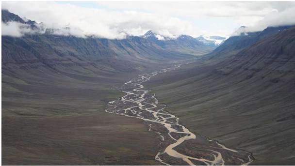
Aaffarsuaq Valley at Nuussuaq – the valley host several very large well-established drill targets confirmed by geology, geophysics and geochemistry. Source: The Disko-Nuussuaq Ni-Cu-Co-PGM-Au Project, 80 Mile PLC, October 2025
Copyright © 2026
SRK Exploration Limited § ES10161 § June 2026

Acknowledgments
SRK EX would like to acknowledge the support and collaboration provided by USFM Corporation and 80 Mile PLC personnel for this assignment. Their collaboration was greatly appreciated and instrumental to the success of this project.
IMPORTANT NOTICE
This Technical Report Summary has been prepared in accordance with Subpart 1300 of Regulation S-K of the U.S. Securities and Exchange Commission for USFM Corporation (“USFM”) by SRK Exploration Limited. (SRK EX). The quality of information, conclusions, and estimates contained herein are consistent with the quality of effort involved in SRK EX’s services. The information, conclusions, and estimates contained herein are based on: i) information available at the time of preparation, ii) data supplied by outside sources, and iii) the assumptions, conditions, and qualifications set forth in this report. This report is intended for use by USFM subject to the terms and conditions of its contract with SRK EX and relevant securities legislation. The contract permits USFM to file this report as a Technical Report Summary in accordance with Subpart 1300 of Regulation S-K of the U.S. Securities and Exchange Commission. Except for the purposes legislated under provincial securities law, any other uses of this report by any third party is at that party’s sole risk. The responsibility for this disclosure remains with USFM. The user of this document should ensure that this is the most recent Technical Report Summary for the property as it is not valid if a new Technical Report Summary has been issued.
This document, as a collective work of content and the coordination, arrangement and any enhancement of said content, is protected by copyright vested in SRK Exploration Limited.
Outside the purposes legislated under provincial securities laws and stipulated in SRK EX’ client contract, this document shall not be reproduced in full or in any edited, abridged or otherwise amended form unless expressly agreed in writing by SRK EX.
Technical Report Summary for the Disko-Nuussuaq Project
EXECUTIVE SUMMARY
| 1 | EXECUTIVE SUMMARY |
This Technical Report Summary “TRS” has been prepared by SRK Exploration Limited (“SRK EX”) for USFM Corporation (“USFM”) in accordance with Subpart 1300 of Regulation S-K of the US Securities and Exchange Commission. The report summaries the geological setting, exploration history, exploration results, and future exploration potential of the Disko-Nuussuaq Project in West Greenland. The Project is an early-stage nickel-copper-cobalt-platinum group element (“Ni-Cu-Co-PGE”) +/- gold exploration project and does not contain Mineral Resources or Mineral Reserves.
The Disko-Nuussuaq Project comprises six mineral exploration licences covering approximately 3,015 km2 on Disko Island and the Nuussuaq Peninsula in west-central Greenland. The licences are held by Nikkeli Greenland A/S, a wholly owned subsidiary of 80 Mile PLC. Under a farm-in agreement executed in 2025, USFM may earn a 51% interest in the Project through exploration expenditures of up to US$30 million over three years, while 80 Mile PLC remains project operator and retains a 49% interest. The Project is located approximately 150 km northwest of Ilulissat and is accessible by fixed-wing aircraft, helicopter, and seasonal maritime transport.
The Project lies within the Palaeogene West Greenland Flood basalt Province, part of the North Atlantic Igneous Province. Exploration is focused on magmatic Ni-Cu-Co-PGE sulphide mineralisation associated with mantle-derived picritic magmas emplaced through feeder conduits, dykes, sills and intrusive complexes with the Cretaceous Nuussuaq sedimentary basin.
The exploration model is based on geological similarities with globally significant magmatic sulphide districts, particularly the Norilsk-Talnakh district in Russia. The two projects share key geological characteristics such as primitive metal-rich magmas, evidence of crustal contamination by sulphide-rich and carbonaceous sediments, major crustal scale corridors, and occurrences of nickel-bearing intrusions. Recent geochemical studies identified surface anomalies displaying indications of the existence of prospective systems, including elevated Ni-Cu-PGE signatures, indications of sulphide saturation and metal transport.
Exploration within the district has been undertaken intermittently since the late 19th century and includes modern exploration activities conducted for both hydrocarbon and metals exploration. These activities include mapping, surface geochemical sampling, multiple phases of airborne and ground geophysical surveys, as well as seismic and gravity modelling. To date, several early-stage targets have been identified with only limited preliminary follow-up drill testing. Historical drilling successful intersected anomalous intrusive bodies but has not identified economic concentrations of Ni-Cu-Co-PGE sulphide mineralisation. Recent exploration has worked to advance the understanding of the project through the acquisition of high-quality geophysical data, and application of modern re-processing techniques. This has resulted in delineation of targets which are planned for drill testing from 2026 field season.
SRRK EX considers the Disko-Nuussuaq Project to represent a geologically compelling and underexplored magmatic sulphide exploration opportunity. The Project contains many of the geological, geochemical, structural and geophysical characteristics associated with major conduit-hosted Ni-Cu-Co-PGE sulphide systems elsewhere in the world.
The Project remains at an early exploration stage with multiple prospective targets warranting drill testing with much ground that remains under- or unexplored. Historical exploration has demonstrated strong indications of the presence of a fertile magmatic system that has not been adequately tested. Several robust drill targets exist a Qullissat, Aaffarsuaq Valley and Kuugannguaq structural corridor, and in western Nuussuaq.
| SRK EXPLORATION LIMITED ■ JUNE 2026 | iv |
| Technical Report Summary for the Disko-Nuussuaq Project |
| EXECUTIVE SUMMARY |
At the time of this report there is insufficient information to support the estimation of Mineral resources under the SEC Regulation S-K 1300. However, the absence of economic mineralisation identified reflects the limited extent of deep drilling, rather than a lack of mineral potential.
SRK EX confirms the proposed exploration plan as technically robust and represent the appropriate next step in evaluating mineral potential of the Project. It comprises the drilling of nine diamond drill holes in the Qullissat, Aaffarsuaq Valley, Kuugannguaq, and western Nuussuaq areas, totalling approximately 8,200 m. USFM has allocated a budget of approximately USD 10 million to this programme which SRK EX considers to be reasonable and justified.
Table 1-1: Summary details for the Disko-Nuussuaq project
| Detail | |
| Project Name | Disko-Nuussuaq Project |
| Location | Central, west Greenland |
| Project Operator | 80 Mile Plc |
| Commodity | Ni-Cu-Co-PGE +/- Au |
| Stage | Early exploration |
| Project Area | 3,015 km2 |
| Licences | 6 |
| Targets | 5 drill target areas: |
| Qullissat, Kuugannguaq North, Kuugannguaq SE, | |
| Aaffarsuaq Valley and Nuussuaq Peninsula | |
| Resources / Reserves | None |
Sources: SRK, 2026
| SRK EXPLORATION LIMITED ■ JUNE 2026 | v |
| Technical Report Summary for the Disko-Nuussuaq Project |
| TABLE OF CONTENTS |
TABLE OF CONTENTS
| 1 | EXECUTIVE SUMMARY | iv | |
| USEFUL DEFINITIONS | xii | ||
| 2 | INTRODUCTION | 1 | |
| 2.1 | Terms of Reference and Purpose of the Report | 1 | |
| 2.2 | Scope of Work | 2 | |
| 2.3 | Work Programme | 2 | |
| 2.4 | Sources of Information and Basis of Technical Report | 2 | |
| 2.5 | Qualifications | 2 | |
| 2.6 | Independence | 3 | |
| 2.7 | Site Visit | 4 | |
| 2.8 | Declaration | 4 | |
| 3 | PROPERTY DESCRIPTION AND LOCATION | 5 | |
| 3.1 | Ownership | 6 | |
| 3.2 | Mineral Tenure | 6 | |
| 3.3 | Underlying Agreements | 8 | |
| 3.4 | Permits and Authorisation | 8 | |
| 3.5 | Environmental Considerations | 9 | |
| 3.6 | Mining Rights in Greenland | 9 | |
| 3.7 | Duties, Taxes and Royalties | 12 | |
| 4 | ACCESSIBILITY, CLIMATE, LOCAL RESOURCES, INFRASTRUCTURE AND PHYSIOGRAPHY | 13 | |
| 4.1 | Accessibility | 13 | |
| 4.1.1 | Regional Access | 13 | |
| 4.1.2 | Local Access | 14 | |
| 4.2 | Climate | 15 | |
| 4.3 | Local Resources and Infrastructure | 15 | |
| 4.3.1 | Settlements and Workforce | 16 | |
| 4.3.2 | Power and Water | 16 | |
| 4.4 | Physiography | 16 | |
| 5 | HISTORY | 19 | |
| 5.1 | Early Prospecting: 1870–1970 | 22 | |
| 5.2 | Cominco: 1985–1990 | 23 | |
| 5.3 | Falconbridge: 1991–1996 | 23 | |
| 5.3.1 | Exploration in 1991 | 23 | |
| 5.3.2 | Exploration in 1992 and 1993 | 23 | |
| 5.3.3 | Exploration in 1994 | 26 | |
| 5.3.4 | Exploration in 1996 | 32 | |
| 5.4 | grønArctic Energy Inc: 1993–1996 | 33 | |
| 5.5 | Greenland Geological Survey: 1997–2000 | 36 | |
| 5.6 | Vismand Exploration: 2003–2007 | 36 | |
| 5.6.1 | Geophysical Surveys in 2003–2004 | 36 | |
| 5.6.2 | Exploration Drilling in 2007 | 37 | |
| 5.7 | Avannaa Resources: 2012–2015 | 40 | |
| 5.7.1 | Exploration in 2012 | 40 | |
| 5.7.2 | Exploration in 2013 | 41 | |
| 5.7.3 | Exploration in 2014 | 44 | |
| 5.8 | Coastal Ventures A/S: 2013–2014 | 44 | |
| 5.8.1 | Drilling | 44 | |
| 5.9 | SRK EX Comments | 46 | |
| SRK EXPLORATION LIMITED ■ JUNE 2026 | vi |
| Technical Report Summary for the Disko-Nuussuaq Project |
| TABLE OF CONTENTS |
| 6 | GEOLOGICAL SETTING AND MINERALISATION | 47 | |
| 6.1 | Regional Geology | 47 | |
| 6.2 | Local Geology | 51 | |
| 6.2.1 | Basement Geology | 52 | |
| 6.2.2 | Cretaceous Nuussuaq Basin Sediments | 53 | |
| 6.2.3 | Palaeocene Volcanic Rocks | 54 | |
| 6.2.4 | Structural Geology | 59 | |
| 6.3 | Property Geology | 64 | |
| 6.3.1 | Nuussuaq Peninsula | 64 | |
| 6.3.2 | Disko Island | 68 | |
| 6.4 | Mineralisation | 72 | |
| 6.4.1 | Native Iron | 73 | |
| 6.4.2 | Magmatic Ni-Cu-Co-PGE | 73 | |
| 6.5 | DEPOSIT TYPES | 74 | |
| 6.6 | Introduction | 74 | |
| 6.7 | Tectonomagmatic, Petrological and Geochemical Framework | 76 | |
| 6.8 | Conduit Model | 79 | |
| 6.9 | Disko Model Interpretations | 81 | |
| 6.9.1 | Importance of strike-slip margins | 82 | |
| 6.9.2 | Relationship of Ni Deposits to Large Igneous Provinces | 83 | |
| 6.10 | Norilsk Deposit Analogy | 84 | |
| 6.10.1 | Crustal Contamination Analogy | 86 | |
| 7 | EXPLORATION | 88 | |
| 7.1 | Geological Mapping | 88 | |
| 7.1.1 | 2019 Activities | 88 | |
| 7.1.2 | 2022 Activities | 89 | |
| 7.1.3 | SRK Comment | 94 | |
| 7.2 | Geophysics | 94 | |
| 7.2.1 | 2019 Activities | 94 | |
| 7.2.2 | 2022 Activities | 96 | |
| 7.2.3 | SRK Comment | 104 | |
| 7.3 | Surface Geochemistry | 105 | |
| 7.3.1 | Bluejay Mining (2017) | 105 | |
| 7.3.2 | Bluejay Mining (2019) | 105 | |
| 7.3.3 | KoBold Metals (2022) | 112 | |
| 7.4 | SRK Comments | 115 | |
| 8 | SAMPLE PREPARATION, ANALYSES AND SECURITY | 117 | |
| 8.1 | Sample Preparation and Analyses | 117 | |
| 8.1.1 | 2019 Programme | 117 | |
| 8.1.2 | 2022 Programme | 118 | |
| 8.2 | Sample Security and Chain of Custody | 122 | |
| 8.2.1 | 2019 Programme | 122 | |
| 8.2.2 | 2022 Programme | 122 | |
| 8.3 | Specific Gravity Measurement | 123 | |
| 8.4 | Quality Assurance and Quality Control Procedures | 123 | |
| 8.4.1 | Quality Assurance Procedures & Protocols | 123 | |
| 8.4.2 | Certified Reference Materials | 125 | |
| 8.4.3 | Blanks | 126 | |
| 8.4.4 | Field Duplicates | 126 | |
| SRK EXPLORATION LIMITED ■ JUNE 2026 | vii |
| Technical Report Summary for the Disko-Nuussuaq Project |
| TABLE OF CONTENTS |
| 8.5 | SRK EX Comments | 128 | |
| 9 | DATA VERIFICATION | 130 | |
| 9.1 | Verifications by SRK EX | 130 | |
| 9.1.1 | Data Verification | 130 | |
| 9.1.2 | Site Visit | 130 | |
| 9.1.3 | Independent Verification Sampling | 130 | |
| 10 | MINERAL PROCESSING AND METALLURGICAL TESTING | 131 | |
| 11 | MINERAL RESOURCE ESTIMATES | 132 | |
| 12 | MINERAL RESERVE ESTIMATES | 133 | |
| 13 | MINING METHODS | 134 | |
| 14 | RECOVERY AND PROCESSING METHODS | 135 | |
| 15 | PROJECT INFRASTRUCTURE | 136 | |
| 16 | MARKET STUDIES AND CONTRACTS | 137 | |
| 17 | ENVIRONMENTAL STUDIES, PERMITTING, AND SOCIAL OR COMMUNITY IMPACT | 138 | |
| 17.1 | Environmental, Social and Governance Context | 138 | |
| 17.1.1 | Company Governance | 138 | |
| 17.1.2 | Climate and climate change | 138 | |
| 17.1.3 | Land use and land users | 139 | |
| 17.1.4 | Water resources and water users | 139 | |
| 17.1.5 | Nature and protected areas | 140 | |
| 17.2 | Potential ESG Implications | 143 | |
| 17.2.1 | ESG Governance | 143 | |
| 17.2.2 | Land use | 143 | |
| 17.2.3 | Water Resources | 143 | |
| 17.2.4 | Protected Areas / Areas of Importance | 143 | |
| 17.3 | ESG Conclusions and Recommendations | 145 | |
| 18 | CAPITAL AND OPERATING COSTS | 147 | |
| 19 | ECONOMIC ANALYSIS | 148 | |
| 20 | ADJACENT PROPERTIES | 149 | |
| 21 | OTHER RELEVANT DATA AND INFORMATION | 150 | |
| 22 | INTERPRETATION AND CONCLUSIONS | 151 | |
| 22.1 | Introduction | 151 | |
| 22.2 | Interpretations of Geochemical Data | 151 | |
| 22.2.1 | Rock Geochemistry | 151 | |
| 22.2.2 | Stream Sediment Geochemistry | 154 | |
| 22.2.3 | Soil Geochemistry | 154 | |
| 22.2.4 | SRK EX Recommendation | 156 | |
| SRK EXPLORATION LIMITED ■ JUNE 2026 | viii |
| Technical Report Summary for the Disko-Nuussuaq Project |
| TABLE OF CONTENTS |
| 22.3 | Geophysical Data Interpretation | 156 | |
| 22.4 | Concluding Remarks | 157 | |
| 23 | RECOMMENDATIONS | 159 | |
| 23.1 | Phase 1: Scout Diamond Drilling Programme (2026) | 159 | |
| 23.2 | Phase 2: Follow-Up Drilling | 162 | |
| 24 | REFERENCES | 163 | |
| 25 | RELIANCE ON OTHER EXPERTS | 168 | |
Tables
| Table 1-1: | Summary details for the Disko-Nuussuaq project | v |
| Table 3-1: | Mineral Exploration Licence tenure information | 8 |
| Table 5-1: | Summary of historical exploration on the Disko-Nuussuaq project | 19 |
| Table 5-2: | Summary of Falconbridge’s drilling in 1993 | 26 |
| Table 5-3: | Summary of drilling the Serfat area | 28 |
| Table 5-4: | Summary of Falconbridge drilling in the Itilli Valley area | 29 |
| Table 5-5: | Summary of drilling in the Qullissat area | 30 |
| Table 5-6: | Summary of drilling the Sarqaq Valley area | 31 |
| Table 6-1: | Eruptive magmatic events in the Disko-Nuussuaq region. | 55 |
| Table 6-2: | Contaminated units summary | 56 |
| Table 6-3: | Analogies between Ni, Cu and PGE magmatic deposits and conceptual mineralisation at Disko-Nuussuaq | 75 |
| Table 7-1: | Recent exploration undertaken under Nikkeli A/S licence ownership | 88 |
| Table 7-2: | Geophysical methods conducted over Disko and Nuussuaq Licences | 97 |
| Table 7-3: | Bluejay Surface Exploration, 2019 | 106 |
| Table 7-4: | KoBold interpretation of rock and soil geochemistry | 113 |
| Table 8-1: | QA/QC Procedures | 123 |
| Table 8-2: | Geochemical Sampling 2022 QA/QC Procedures | 124 |
| Table 17-1: | Exploration licences impacted by Protected Areas or Areas of Importance. | 144 |
| Table 23-1 | Phase 1 Scout Drill Hole Parameters — Disko–Nuussuaq Project (UTM Zone 22N, WGS84) | 159 |
| Table 25-1: | Historical hole parameters for the Disko-Nuussuaq Project | 172 |
Figures
| Figure 3-1: | Project location | 5 |
| Figure 3-2: | Nikkeli licence areas and adjacent properties | 7 |
| Figure 4-1: | Regional access to the project | 14 |
| Figure 4-2: | Annual climate data for Ilulissat | 15 |
| Figure 4-3: | Typical landscape and vegetation across the Disko Project area | 17 |
| Figure 4-4: | Typical landscape and vegetation across the Disko Project area | 18 |
| Figure 5-1: | Place names as referenced in historical works (red outlines are licences belonging to Nikkeli A/S) | 22 |
| Figure 5-2: | Extent of airborne GEOTEM and magnetic surveys and their anomalies | 24 |
| Figure 5-3: | Falconbridge drilling locations in the Qullissat, Igdlukunguaq, Kuugannguaq Valley and Sarqaq Valley areas | 25 |
| Figure 5-4: | Exploration summary, Falconbridge 1994 | 27 |
| Figure 5-5: | Falconbridge drilling 1994 in the Serfat and Itilli Valley areas | 30 |
| Figure 5-6: | Falconbridge drilling 1994 in the Qullissat and Sarqaq Valley areas | 32 |
| Figure 5-7: | grønArctic drilling on the Nuussuaq Peninsula, 1993 – 1996 | 34 |
| Figure 5-8: | grønArctic Marraat-1 drill hole set up | 35 |
| SRK EXPLORATION LIMITED ■ JUNE 2026 | ix |
| Technical Report Summary for the Disko-Nuussuaq Project |
| TABLE OF CONTENTS |
| Figure 5-9: | Quantec/Vismand MT survey areas, 2004 | 37 |
| Figure 5-10: | Vismand drilling in the Aaffarsuaq valley on the Nuussuaq Peninsula, 2007 | 38 |
| Figure 5-11: | Vismand drill collar locations in the Aaffarsuaq Valley on the Nuussuaq Peninsula, 2007 | 39 |
| Figure 5-12: | Diamond drill rig at V-GRN-1 | 40 |
| Figure 5-13: | Coverage map of 2012 ZTEM survey | 41 |
| Figure 5-14: | Vibro-seismic lines in the Kuugannguaq Valley | 42 |
| Figure 5-15: | Seismic section from south to north through the Kuugannguaq Valley with interpreted intrusions (from Clausen and Nørmark, 2014) | 43 |
| Figure 5-16: | Coastal Ventures drilling on the Disko-Nuussuaq project 2013 - 2014 | 45 |
| Figure 5-17: | Coal intersected in hole CV-NUS-020 | 46 |
| Figure 6-1: | Onshore geology of Greenland. | 49 |
| Figure 6-2: | Simplified geological map of West Greenland and the Nuussuaq Basin. | 50 |
| Figure 6-3: | Local geology of the Disko-Nuussuaq area | 51 |
| Figure 6-4: | DIsko Island geology and Palaeocene stratigraphy | 54 |
| Figure 6-5: | Contaminated Vaigat Asuk Member | 57 |
| Figure 6-6: | Eruption sites for contaminated units | 58 |
| Figure 6-7: | Geological and structural overview of Disko Island and the Nuussuaq Peninsula | 61 |
| Figure 6-8: | Project stratigraphy and map legend | 62 |
| Figure 6-9: | Licences across Nuussuaq | 65 |
| Figure 6-10: | Geological map of Nuussuaq and northern Disko showing extent of erupted Ananna and Nuuk Killeq Members | 66 |
| Figure 6-11: | Evolution of the Itilli Fault Zone and west Nuussuaq basin. | 67 |
| Figure 6-12: | Cross-section through Nuussuaq and Aaffarsuaq valley. | 68 |
| Figure 6-13: | Local geology of the Disko Island licence areas | 69 |
| Figure 6-14: | Aerial image of the Qullissat area and Falconbridge drilling | 70 |
| Figure 6-15: | Photogrammetry section of Qullissat | 71 |
| Figure 6-16: | Types of Primary Magmatic Sulphide Deposits | 75 |
| Figure 6-17: | Crustal Contamination in West Greenland | 78 |
| Figure 6-18: | Conduit Model for Magmatic Sulphide Deposits | 80 |
| Figure 6-19: | Kuugannguaq–Qunnilik (K–Q) Fault | 83 |
| Figure 6-20: | Norlisk Deposit Model | 85 |
| Figure 6-21: | Crustal Contamination into volcanic sequences of Norlisk and West Greenland | 87 |
| Figure 7-1: | Geological map of the Qullissat area in MEL 2018-16 | 90 |
| Figure 7-2: | Geological map of the Igdlukunguaq area in MEL 2017-01 | 91 |
| Figure 7-3: | Stratigraphic section near Igdlukunguaq | 92 |
| Figure 7-4: | Titan-24 DCIP/MT Survey acquisition layout | 95 |
| Figure 7-5: | Titan-24 IP inversion for line L10N in the Aaffarsuaq Valley | 96 |
| Figure 7-6: | Bathymetry survey | 98 |
| Figure 7-7: | Xcalibur Airborne gravity gradiometry and magnetics | 99 |
| Figure 7-8: | EarthEx UAV-borne magnetic surveys | 100 |
| Figure 7-9: | HeliSAM helicopter-borne electromagnetic surveys | 101 |
| Figure 7-10: | Gravity models | 102 |
| Figure 7-11: | Gravity and Electromagnetic survey in Qullissat at surface | 103 |
| Figure 7-12: | Identified EM anomalies | 104 |
| Figure 7-13: | Sample of massive sulphide from the area of the Igdlukunguaq dyke | 105 |
| Figure 7-14: | Soil sampling locations | 107 |
| Figure 7-15: | MMI soil geochemistry results (response ratios for nickel at Qullissat | 108 |
| Figure 7-16: | MMI soil geochemistry results (response ratios for nickel at Igdlukunguaq | 109 |
| Figure 7-17: | MMI soil geochemistry results (response ratios for nickel at Affaarsuaq | 110 |
| Figure 7-18: | MMI soil geochemistry results (response ratios for nickel at Kuug Valley | 111 |
| Figure 7-19: | Spatial Distribution of Ni concentrations in MMI samples at Qullissat | 113 |
| Figure 7-20: | Ni results from grab sampling in 2022 | 115 |
| SRK EXPLORATION LIMITED ■ JUNE 2026 | x |
| Technical Report Summary for the Disko-Nuussuaq Project |
| TABLE OF CONTENTS |
| Figure 8-1: | Soil sampling procedure | 119 |
| Figure 8-2: | Stream sediment sampling procedures | 120 |
| Figure 8-3: | Excerpts of CRM plots for Ni and Co | 126 |
| Figure 8-4: | Excerpts of duplicate results for Ni and Co | 128 |
| Figure 17-1: | Areas of environmental importance | 142 |
| Figure 20-1: | Map showing the licences around Disko Island | 149 |
| Figure 22-1: | Interpretation of rock groups | 151 |
| Figure 22-2: | Magmatic System Fertility | 153 |
| Figure 22-3: | Massive Sulphide Generation | 153 |
| Figure 22-4: | Magmatic fractionation and sulphide segregation into Stream Sediments Samples | 154 |
| Figure 22-5: | Pd Anomalies in soil samples | 155 |
| Figure 22-6: | Ni-Cu-PGE in soil samples relative to primitive mantle | 155 |
| Figure 22-7: | Geochemical Interpretation | 156 |
| Figure 23-1: | 80 Mile planned drilling with historic holes across the Disko-Nuussuaq Project | 161 |
Appendices
| Appendix A | Point Licence Co-ordinates |
| Appendix B | Drill collar information |
| SRK EXPLORATION LIMITED ■ JUNE 2026 | xi |
| Technical Report Summary for the Disko-Nuussuaq Project |
| USEFUL DEFINITIONS |
USEFUL DEFINITIONS
This list contains definitions of symbols, units, abbreviations, and terminology that may be unfamiliar to the reader.
| Adjacent property | A property in which the Issuer does not have an interest, that has a boundary reasonably proximate to the property being reported on and that has geological characteristics similar to those of the property being reported on (CSA, 2011). |
| Advanced property | A property that has mineral reserves, or mineral resources the potential economic viability of which is supported by a preliminary economic assessment, a pre-feasibility study or a feasibility study (CSA, 2011). |
| Alluvial | Generally unconsolidated lithic material deposited by running water in drainage channels and on floodplains. period |
| Archean | The geological time interval from 4,000 to 2,500 million years ago. |
| Au | The chemical symbol for gold. |
| Blank | Material containing very low or non-detectable concentrations of the element of interest that is inserted into sample batches and used to assess contamination. |
| Certified reference material | Material of known elemental concentration that is inserted into sample batches and used to assess the accuracy of the analytical results. Often represented by the acronym “CRM”. |
| Craton | The large and stable interior part of a continent that is characteristically composed of ancient crystalline basement rock. |
| Data verification | The process of confirming that data has been generated with proper procedures, has been accurately transcribed from the original source and is suitable to be used (CSA, 2011). |
| Early stage property | A property that has no current mineral resources or mineral reserves defined and no drilling or trenching proposed (CSA, 2011). |
| Effective date | The date of the most recent scientific or technical information included in the Technical Report (CSA, 2011). |
| Eluvial | Consolidated and unconsolidated lithic material formed due to in-situ weathering. |
| Exploration information | Geological, geophysical, geochemical, sampling, drilling, trenching, analytical testing, assaying, mineralogical, metallurgical, and other similar information concerning a particular property that is derived from activities undertaken to locate, investigate, define, or delineate a mineral prospect or mineral deposit (CSA, 2011). |
| Field duplicate | Two samples derived from the same sample interval that are used to assess the repeatability of the analytical results. |
| g/t | Abbreviation for grammes per tonne. Synonymous with parts per million (ppm). |
| Ga | Billion years ago. |
| Issuer | Any entity that issues a security. Issuers can include individuals, companies and partnerships, etc. Securities include shares, options, interests in properties, profits, earnings and royalties, etc. |
| Ma | Million years ago. |
| Material | In the context of technical reporting, any data or information that has significance, importance or consequence. |
| Mobile belt | Crustal lithological units that have been deformed into elongated regions along the edges of cratons. |
| Orogen | A mountain building process that occurs at a convergent plate margin in response to compression. |
| SRK EXPLORATION LIMITED ■ JUNE 2026 | xii |
| Technical Report Summary for the Disko-Nuussuaq Project |
| USEFUL DEFINITIONS |
| Paleoproterozoic | The geological time interval from 2,500 to 1,600 million years ago. |
| Phanerozoic | The geological time interval from approximately 500 million years ago to the present. |
| ppb | Acronym for parts per billion. |
| ppm | Acronym for parts per million. Synonymous with grammes per tonne (g/t). |
| Qualified Person | An individual who meets the requirements of NI 43-101 Section 1.1 (CSA, 2011). |
| Quality Assurance | In the context of exploration geochemistry, Quality Assurance (QA) constitutes the pre-analysis measures used to try and ensure sample result accuracy. For example, the inclusion of blanks, certified reference materials and field duplicates in sample batches. |
| Quality Control | In the context of exploration geochemistry, Quality Control (QC) constitutes the post-analysis measures to try and ensure sample result accuracy. For example, the use of control and correlation plots. |
| Regolith | The weathered material between the ground surface and unweathered rock. Sometimes referred to as ‘all the material between fresh air and fresh rock’. |
| Shield | A large area of exposed Precambrian crystalline basement rock that forms part of a craton. |
| S-K 1300 | Subpart 1300 of Regulation S-K of the U.S. Securities and Exchange Commission for disclosure of mining properties. |
| Technical Report Summary | A summary technical report prepared in accordance with Subpart 1300 of Regulation S-K and Item 601(b)(96) of Regulation S-K of the U.S. Securities and Exchange Commission that describes the results of mineral exploration, development, or production activities on a property and includes all material scientific and technical information about that property. |
| wt% | Weight percent. |
| SRK EXPLORATION LIMITED ■ JUNE 2026 | xiii |
| Technical Report Summary for the Disko-Nuussuaq Project |
| INTRODUCTION |
| 2 | INTRODUCTION |
The Disko-Nuussuaq project is an early-stage Ni-Cu-Co-PGE ± Au exploration project located in Greenland. It is located on the central, west coast of Greenland, approximately 150 km northwest of the town of Ilulissat.
In May 2026, USFM Corporation (“USFM”) commissioned SRK Exploration Limited (“SRK EX”) to prepare an independent Technical Report Summary (“TRS”) on the Disko-Nuussuaq project. This technical report summary was prepared in accordance with the SEC S-K regulations (Title 17, Part 229, Items 601 and 1300 through 1305). These services were rendered between May and June 2026, leading to the preparation of a summary of historical exploration and mineral potential reported herein.
The mineral licences for the Disko-Nuussuaq project are wholly owned by 80 Mile PLC (“80 Mile”), who is the operator of the project. USFM is providing the funding for exploration and requires the TRS so that it can potentially be lodged on a US stock exchange. The TRS has been prepared to meet the requirements of the Securities Exchange Commission (“SEC”) and in accordance with SEC Regulation S-K 1300, an SEC rule for the public reporting of exploration and mining projects.
| 2.1 | Terms of Reference and Purpose of the Report |
The quality of information, conclusions, and estimates contained herein are consistent with the level of effort involved in SRK’s services, based on:
| § | Information available at the time of preparation |
| § | Assumptions, conditions, and qualifications set forth in this report |
This report is intended for use by USFM subject to the terms and conditions of its contract with SRK EX and relevant securities legislation. The contract permits USFM to file this report as a technical report summary with American securities regulatory authorities pursuant to the SEC S-K regulations, more specifically Title 17, Subpart 229.600, item 601(b)(96) - Technical Report Summary and Title 17, Subpart 229.1300 - Disclosure by Registrants Engaged in Mining Operations. Except for the purposes legislated under U.S. federal securities law, or with other securities regulators as specifically consented to by SRK EX, any other use of this report by any third party are at that party’s sole risk. The responsibility for this disclosure remains with USFM.
The purpose of this technical report summary is to report exploration results for the Disko Project. The effective date of this report is 30th June 2026.
References to industry best practices contained herein are generally in reference to those documented practices as defined by organizations, such as the Society for Mining Metallurgy and Exploration (SME), the Canadian Institute of Mining, Metallurgy, and Petroleum (CIM), or international reporting standards as developed by the Committee for Mineral Reserves International Reporting Standards (CRIRSCO).
| SRK EXPLORATION LIMITED ■ JUNE 2026 | 1 |
| Technical Report Summary for the Disko-Nuussuaq Project |
| INTRODUCTION |
| 2.2 | Scope of Work |
The scope of work, as defined in a contract P1353 Proposal for Technical Report Summary for the Disko-Nuussuaq Project, executed on 28 April 2026 between USFM and SRK EX, includes:
| § | Review of regional and local geology for the project areas; |
| § | Review of the exploration conducted by previous operators in the project areas; |
| § | Audit of recent exploration conducted by 80 Mile and associated organisations in the project areas; |
| § | Review of the Environmental, Social and Governance (“ESG”) context of the project, the Company’s commitments in this regard and Environmental and Social activities conducted to date; |
| § | Review and commentary on the Company’s proposed exploration programmes for the project and the associated exploration budgets, as well as additional recommendations; |
| § | Recommendations for additional work; and, |
| § | Compilation of a TRS following S-K 1300 guidelines. |
| 2.3 | Work Programme |
The production of this TRS has been a collaborative effort between 80 Mile PLC, USFM and SRK EX personnel. Geological data, exploration data and exploration reports were compiled by 80 Mile on behalf of UDSFM and provided to SRK EX for review and used in the compilation of this TRS.
The technical report was assembled in SRK EX’s Cardiff, UK, office between May and June 2026.
| 2.4 | Sources of Information and Basis of Technical Report |
This report is based on exploration data provided by USFM from previous work undertaken on behalf of USFM by 80 Mile PLC, formerly Bluejay Mining PLC, KoBold Metals, and historical work. SRK EX have also reviewed information from public domain sources in the production of this TRS.
SRK EX has no reason to doubt the reliability of the information provided by USFM or 80 Mile. There is no previously filed TRS for this project.
| 2.5 | Qualifications |
SRK EX is part of the international group holding company, SRK Consulting (Global) Limited (the “SRK Group”). The SRK Group comprises more than 1,800 professionals, offering expertise in a wide range of mineral resource engineering disciplines. SRK has a proven track record in undertaking independent assessments of mineral resources and mineral reserves, project evaluations and audits, technical reports and independent feasibility evaluations to bankable standards on behalf of exploration and mining companies, and financial institutions worldwide. Through its work with a large number of international mining and exploration companies, the SRK Group has established a reputation for providing valuable consultancy services to the global mining industry.
This report was prepared by SRK Exploration Ltd. (“SRK EX”), a third-party firm comprising mineral exploration experts in accordance with § 229.1302(b)(1). USFM has determined that SRK meets the qualifications specified under the definition of Qualified Person in § 229.1300. References to the QP in this report are references to SRK Exploration Ltd. and not to any individual employed at SRK.
| SRK EXPLORATION LIMITED ■ JUNE 2026 | 2 |
| Technical Report Summary for the Disko-Nuussuaq Project |
| INTRODUCTION |
SRK EX qualifies as a QP based on the S-K 1300 definition of and has utilised individuals who:
| 1. | A mineral industry professional with at least five years of relevant experience in the type of mineralization and type of deposit under consideration and in the specific type of activity that person is undertaking on behalf of the Registrant; and |
| 2. | An eligible member or licensee in good standing of a recognized professional organization at the time the technical report is prepared. For an organization to be a recognized professional organization, it must: |
(i) Be either:
(A) An organization recognized within the mining industry as a reputable professional association; or
(B) A board authorized by U.S. federal, state or foreign statute to regulate professionals in the mining, geoscience or related field;
(ii) Admit eligible members primarily on the basis of their academic qualifications and experience;
(iii) Establish and require compliance with professional standards of competence and ethics;
(iv) Require or encourage continuing professional development;
(v) Have and apply disciplinary powers, including the power to suspend or expel a member regardless of where the member practices or resides; and
(vi) Provide a public list of members in good standing.
| 2.6 | Independence |
Both SRK EX and the QP are independent of the Issuer (USFM) given there is no circumstance that, in the opinion of a reasonable person aware of all relevant facts, could interfere with the preparation of the Technical Report. Further, both SRK EX and the QP are defined as follows:
| 1. | Is not an employee, insider, or director of the Issuer. |
| 2. | Is not an employee, insider, or director of a related party of the Issuer. |
| 3. | Is not a partner of any person or company in paragraph (a) or (b). |
| 4. | Does not hold or expects to hold securities, either directly or indirectly, of the Issuer or a related party of the Issuer, meaning an affiliate, associate, subsidiary, or control person of the issuer. |
| 5. | Does not hold or expect to hold securities, either directly or indirectly, in another issuer that has a direct or indirect interest in the property that is the subject of the Technical Report or in an Adjacent Property. |
| 6. | Is not an employee, insider, or director of another Issuer that has a direct or indirect interest in the property that is the subject of the technical report or in an Adjacent Property. |
| 7. | Does not have or expect to have, directly or indirectly, an ownership, royalty, or other interest in the property that is the subject of the Technical Report or an Adjacent Property. |
| SRK EXPLORATION LIMITED ■ JUNE 2026 | 3 |
| Technical Report Summary for the Disko-Nuussuaq Project |
| INTRODUCTION |
| 8. | Has not received the majority of their income, either directly or indirectly, in the three years preceding the date of the Technical Report from the Issuer or a related party of the Issuer. |
| 2.7 | Site Visit |
A site visit has not yet been conducted by the QP. This is because, at the time of writing, the 2026 exploration programme has not commenced and the logistical platform is not in place to facilitate a visit. A QP visit is however scheduled to take place during late July 2026 after the commencement of a drilling programme.
| 2.8 | Declaration |
SRK EX’ opinion contained herein and effective 30th June 2026 is based on information collected by or provided to SRK EX throughout the course of SRK EX’ investigations. The information in turn reflects various technical and economic conditions at the time of writing this report. Given the nature of the exploration and mining business, these conditions can change significantly over relatively short periods of time. Consequently, actual results may be significantly more or less favourable.
This report may include technical information that requires subsequent calculations to derive subtotals, totals, and weighted averages. Such calculations inherently involve a degree of rounding and consequently introduce a margin of error. Where these occur, SRK EX does not consider them to be material.
SRK EX is not an insider, associate or an affiliate of USFM, and neither SRK EX nor any affiliate has acted as advisor to USFM, its subsidiaries or its affiliates in connection with this project. The results of the technical review by SRK EX are not dependent on any prior agreements concerning the conclusions to be reached, nor are there any undisclosed understandings concerning any future business dealings.
| SRK EXPLORATION LIMITED ■ JUNE 2026 | 4 |
| Technical Report Summary for the Disko-Nuussuaq Project |
| PROPERTY DESCRIPTION AND LOCATION |
| 3 | PROPERTY DESCRIPTION AND LOCATION |
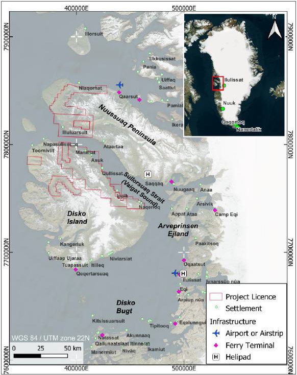
The Disko-Nuussuaq project is an early-stage Ni-Cu-Co-PGE ± Au exploration project located in Greenland. It is located on the central, west coast of Greenland, approximately 150 km northwest of the town of Ilulissat. Figure 3-1 shows the project licence areas and local settlements.
Figure 3-1: Project location
Sources: SRK Exploration, 2026
Notes: Inset map displays major settlements with main airports of Greenland
| SRK EXPLORATION LIMITED ■ JUNE 2026 | 5 |
| Technical Report Summary for the Disko-Nuussuaq Project |
| PROPERTY DESCRIPTION AND LOCATION |
| 3.1 | Ownership |
The area has been explored since the late 1800s, and early exploration activities are well summarised in Larsen and Pedersen (2009). Various onshore and offshore surveys were undertaken following this during several phases of hydrocarbon exploration dating from the 1980s to modern times.
In September 2016, the project was purchased by Bluejay Mining (then FinnAust Mining), from Cairn Energy and Bluejay carried out exploration under its wholly-owned subsidiary, Disko Exploration Ltd. Licences were also acquired from Coastal Ventures A/S in 2017.
In August 2021, Bluejay entered into a Joint Venture agreement with KoBold Metals through its wholly-owned subsidiary, Disko Exploration Ltd. Under the terms of the agreement, KoBold could earn 51% operating interest through a $15 million investment in exploration.
In February 2022, Bluejay formally incorporated Nikkeli Greenland A/S as the Greenlandic operating entity and legal holder of the exploration licences. Furthermore, Bluejay rebranded as 80 Mile PLC in July 2024.
During the Joint Venture with KoBold, roughly $13.4 million was spent on geophysical surveys, data processing, artificial intelligence and exploration tools but exploration failed to progress to drilling. In May 2025, the agreement was terminated early, returning full project interests to 80 Mile PLC while KoBold went on to focus on copper assets in Zambia. Under the terms of this agreement, KoBold retains a net smelter return royalty on future production.
After regaining full control, 80 Mile PLC restructured its asset ownership to fund further exploration and entered a binding agreement with USFM Corporation in late 2025. USFM Corporation is a private, US-based mineral exploration and investment company based in Golden, Colorado, and was established to focus on advancing drilling to develop world class tier-1 assets and develop a Western-backed pipeline of magmatic Ni-Cu-Co-PGE resources. Under the agreement, USFM can earn a 51% Farm-In interest through investment of US$30 million over three years into new exploration drilling. 80 Mile remains the project operator, retaining a 49%, free-carried interest, and earns a 12.5% management fee on all exploration capital expenditure by USFM (source: 80 Mile PLC). Nikkeli Greenland A/S remains the legal permit holders for the Disko-Nuussuaq licences and remains the wholly owned subsidiary of 80 Mile PLC.
| 3.2 | Mineral Tenure |
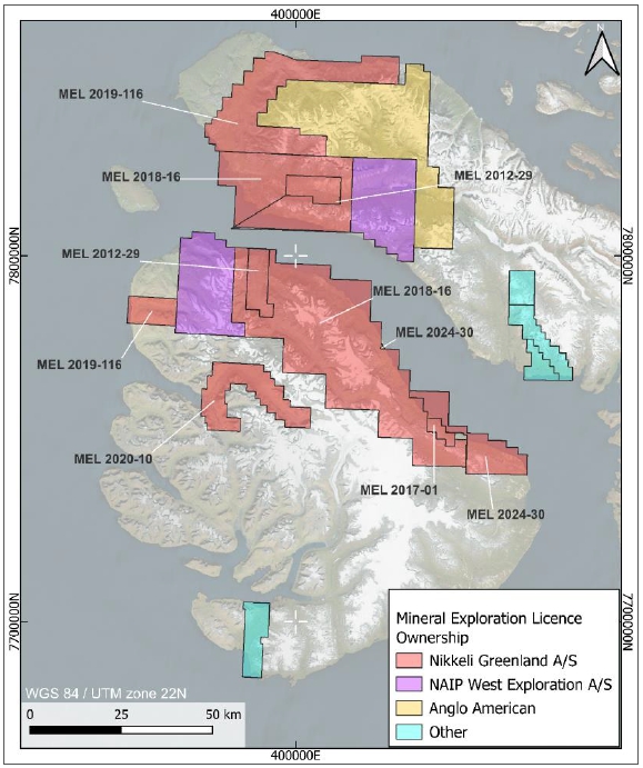
Between 2011 and 2022, 80 Mile acquired mineral exploration licences under their Greenlandic-based, wholly-owned subsidiary Nikkeli Greenland A/S to explore for Ni-Cu-PGE-Au deposits in West Greenland. There are six licences, totalling a combined area of 3,015 km2. Three of the licences comprise two separate areas. Figure 3-2 illustrates the locations of the six licences and their details are summarised in Table 3-1. Co-ordinates for all licences are provided in Appendix A.
| SRK EXPLORATION LIMITED ■ JUNE 2026 | 6 |
| Technical Report Summary for the Disko-Nuussuaq Project |
| PROPERTY DESCRIPTION AND LOCATION |
Figure 3-2: Nikkeli licence areas and adjacent properties
Sources: SRK Exploration, 2026; MLSA
Notes: Coordinates in UTM Zone 22N, WGS84
Mineral exploration licences are issued for a period of five years and are renewable up to a total duration of 22 years. The project licence areas will be renewable until the earliest reaches expiry in 2036, posing little risk to exploration activity.
SRK EX notes that licence MEL 2019-116 expired at the end of 2025. SRK EX has been informed by 80 Mile that an application for renewal of this licence has been made and it is under review by the Mineral Licensing and Safety Authority (“MLSA”) in Greenland. 80 Mile further states that the licence was in good standing at the time of expiry and there is no reason why it’s renewal should not be granted.
| SRK EXPLORATION LIMITED ■ JUNE 2026 | 7 |
| Technical Report Summary for the Disko-Nuussuaq Project |
| PROPERTY DESCRIPTION AND LOCATION |
| Table 3-1: | Mineral Exploration Licence tenure information |
| Licence No. | Owner | Granted Date | Expiry Date | Status | Area (km2) | |
| 1 | MEL-2018-16 | Nikkeli Greenland A/S | 01/01/2018 | 31/12/2029 | Active | 1,698 |
| 2 | MEL-2012-29 | Nikkeli Greenland A/S | 01/01/2012 | 31/12/2026 | Active | 194 |
| 3 | MEL 2017-01 | Nikkeli Greenland A/S | 01/01/2018 | 31/12/2028 | Active | 28 |
| 4 | MEL-2024-30 | Nikkeli Greenland A/S | 21/03/2024 | 31/12/2028 | Active | 112 |
| 5 | MEL 2020-10 | Nikkeli Greenland A/S | 25/02/2020 | 31/12/2026 | Active | 288 |
| 6 | MEL-2019-116 | Nikkeli Greenland A/S | 30/08/2019 | 31/12/2025 | Under review | 695 |
Sources: 80 Mile PLC
| 3.3 | Underlying Agreements |
In late 2025, USFM Corporation entered into a Joint venture agreement with 80 Mile Plc. Under the terms of the agreement, USFM invested US$30 million earning a 51% interest in the project while 80 Mile maintains operator status and a 49% free-carried stake. Under the terms of the agreement, USFM bears 100% of site restoration and rehabilitation costs.
80 Mile Plc is an exploration and development company listed on the London AIM, Frankfurt and US OTC stock markets. The company holds a portfolio of nickel, copper, cobalt and PGM projects across Greenland, Finland, and Italy. 80 Mile wholly owns local subsidiary Nikkeli Greenland A/S.
During the dissolution of the 80 Mile – Kobold JV in 2025, KoBold has retained a net smelter return royalty on future production however the details of this are unknown.
SRK is not aware of any other underlying interests in this project and has not consulted legal advice to this effect.
| 3.4 | Permits and Authorisation |
The Ministry of Mineral Resources (“MMR”) is responsible for strategy, policy, and legal aspects of mineral exploration and mining activities including socio-economic factors such as social impact assessments.
Prospecting, exploration and mining licences are administered by the Mineral Licence and Safety Authority (“MLSA”) which sits within the MMR. They also carry out inspections including monitoring of safety matters.
There is no land ownership in Greenland, so activities and mining rights are regulated by the government. There is no landscape of privately-held surface or indigenous mining rights to navigate.
Mineral ownership in Greenland belongs wholly to the Greenlandic government.
| SRK EXPLORATION LIMITED ■ JUNE 2026 | 8 |
| Technical Report Summary for the Disko-Nuussuaq Project |
| PROPERTY DESCRIPTION AND LOCATION |
Exploration licence holders are required submit details of planned exploration work to the MLSA for approval. Furthermore, they are required to report all geological, geochemical, geophysical, environmental or other related investigations regarding licence areas annually to the MLSA.
SRK EX has been informed by 80 Mile that the Company has all required approvals for exploration activities in 2026. This also applies to EL 2019-116, despite the Company not yet having received certification of its renewal.
| 3.5 | Environmental Considerations |
Environmental matters related to mining and mineral exploration are administered by the Environmental Agency for the Mineral Resources Area (EAMRA). The body sits with the Ministry for Environment and Nature and monitors activities related to environmental liability and environmental impact assessments.
Protected areas within or near the licence areas are discussed in Section 17 of this report.
| 3.6 | Mining Rights in Greenland |
Mineral ownership in Greenland belongs wholly to the Greenlandic government. There is no private mineral ownership framework.
Since January 2024, all activities related to prospecting, exploration and mining for minerals are governed by the Greenland Minerals Act (dated 13 June 2023), known as “the Mining Act”. It replaces the Greenland Parliament Act of 7 December 2009 on Mineral Resources and Mineral Resource Activities (the Mineral Resources Act). The Mining Act was introduced to separate small-scale activities from that of larger commercial exploration. Companies must adhere to updated legislation regarding environment, and local and foreign employment. Updates include:
| § | Licence holders must be registered as a public or private Greenlandic company |
| § | The total period for prospecting licences including renewals is extended to 15 years, and 22 years for exploration licences. |
| § | Public consultation is required during the application process for all exploration licences. |
| § | Rules for granting of a mining licence were relaxed and include the following provisions: |
| – | Public consultation is required during the application process |
| – | A mining licence can be granted prior to formal approval of Environmental and Social Impact Assessments, fast-tracking the approvals process. |
| – | Company holders must be Greenlandic based. |
In Greenland, all uranium prospecting is banned, and there are limits to exploration of areas if the average uranium content of the resource is deemed to be equal to or over 100ppm U.
Rights to prospect, explore and mine are granted according to the Standard Terms for Exploration Licences for Minerals (Excluding Hydrocarbons) dated 25 June 2013.
The following types of commercial mineral licence are available in Greenland.
| SRK EXPLORATION LIMITED ■ JUNE 2026 | 9 |
| Technical Report Summary for the Disko-Nuussuaq Project |
| PROPERTY DESCRIPTION AND LOCATION |
Prospecting Licences
These are intended for early-stage mineral prospecting activities (excluding drilling) and are granted for periods of up to five years at a time and may be renewed for up to 15 years in total. They do not confer any exclusive rights to exploration and a similar licence or other types of licence may be granted to others for the same area. There is an application fee of DKK 3,000 and a granting fee (on approval) of DKK 28,000 (2026). There are no annual fees or minimum exploration expenditure commitments.
Exploration Licences
These provide exclusive rights for the licensee to undertake mineral exploration activities for all commodities within the licence area, excluding hydrocarbons, radioactive elements and hydropower, and mineral resources stated in the Act 20 and in Executive order No. 1 of 7 January 2025 on limitation of certain mineral resources (certain gemstones and collectors’ stones reserved for local mineral activities). They must have a minimum size of 5 km2 and may consist of up to five separated sub-areas with no more than 100 km distance between areas.
Exploration Licences are granted for an initial period of five years, after which the licensee is entitled to apply for a new period of five years for the same area. At the expiry of the second licence period (years 6-10), the licensee may apply for further three-year periods for the same area up to a maximum of 22 years (years 11-13, 14-16, 17-19 and 20-22).
The licensee is committed to a defray a minimum exploration expenditure per licence per year. The exploration obligation is defined as a fixed amount per licence plus a fixed amount per square kilometre annually which increase with the age of the licence. This amount is defined by the Government and is mainly the same for all exploration licences, and it also increases with the age of the licence.
The current fee structure for Exploration Licences is as follows (2026):
One-off fees
| · | Application fee: DKK 5,000 | |
| · | Granting fee: DKK 40,800 | |
| · | Granting fee for transfer or area enlargement: DKK 23,300 |
Minimum exploration expenditure commitments:
| § | Per licence (per calendar year): |
| – | Year 1–2: DKK 187,000 | |
| – | Year 3–5: DKK 373,000 | |
| – | Year 6–10: DKK 747,000 | |
| – | Year 11–13: DKK 1,490,000 | |
| – | Year 14–16: DKK 2,990,000 | |
| – | Year 17–19: DKK 5,970,000 | |
| – | Year 20–22: DKK 11,940,000 |
| SRK EXPLORATION LIMITED ■ JUNE 2026 | 10 |
| Technical Report Summary for the Disko-Nuussuaq Project |
| PROPERTY DESCRIPTION AND LOCATION |
| § | Plus area-based commitments (per km2): |
| – | Year 1–2: DKK 1,870 / km2 | |
| – | Year 3–5: DKK 9,340 / km2 | |
| – | Year 6–10: DKK 18,700 / km2 | |
| – | Year 11–13: DKK 37,300 / km2 | |
| – | Year 14–16: DKK 74,700 / km2 | |
| – | Year 17–19: DKK 149,000 / km2 | |
| – | Year 20–22: DKK 298,000 / km2 |
Annual fees
| · | DKK 46,700 per year, from Year 6 onward |
Special Exploration Licences
These are designed to enable early-stage, belt-scale exploration over large and remote areas of North and East Greenland (where logistical and access costs may significantly exceed those in other regions) prior to application for standard exploration licences over selected sub-areas. They provide exclusivity and must cover a minimum area of 1,000 km2. There is no maximum size. They are granted for a non-renewable term of up to three years and carry reduced annual exploration expenditure commitments relative to standard exploration licences.
One-off fees
| § | Application fee: DKK 5,000 | |
| § | Granting fee: DKK 40,800 |
Annual commitments (reduced)
| § | Exploration obligation: DKK 934 per km2 per year |
Exploitation Licences
An Exploitation Licence may be granted to exploit one or more minerals for a specified area and on specific terms to an Exploration Licence holder (“Licensee”) who has has substantiated and delineated a viable mineral deposit which the Licensee intends to exploit, and has performed all of its obligations in relation to the Exploration Licence and activities under the licence. The Government of Greenland will decide whether the conditions have been met.
Before an Exploitation Licence can be granted, the Licensee must prepare a project terms of reference document which must be put in public consultation (35 days), and where appropriate combined with the terms of reference for the EIA and SIA. Completion and approval of the full EIA and SIA are then postponed to after grant of an Exploitation Licence, but before exploitation may be initiated.
| SRK EXPLORATION LIMITED ■ JUNE 2026 | 11 |
| Technical Report Summary for the Disko-Nuussuaq Project |
| PROPERTY DESCRIPTION AND LOCATION |
The licence conveys the Licensee exclusive rights to exploitation and exploration and is granted for a period of 30 years (unless a shorter period is stipulated as a condition) up to a maximum of 50 years. The licence is terminated when exploitation activities have ceased and a closure plan (agreed with the Government at the time of application for the Exploitation Licence) has been completed to the Government’s satisfaction.
Suspension of exploitation activities with a view to their subsequent resumption is possible but subject to approval by the Government. Approval may be granted for up to two years at a time, and renewed approval may be granted on modified terms.
One-off fees
| § | Granting fee: DKK 100,000 |
Other financial requirements
| § | Financial security for closure and remediation |
| § | Royalties, corporate tax, and other fiscal terms (project-specific) |
| 3.7 | Duties, Taxes and Royalties |
Under the terms of an Exploitation Licence, the following are payable:
| § | Corporate tax according to Greenlandic tax legislation; |
| § | A royalty; |
| § | A fee for the granting of the licence (100,000 Danish kroner); |
| § | The reimbursement of all related and factual expenses associated with processing by authorities in relation to the exploitation licence; and |
| § | Other payments as may stipulated under the licence, for example, under the Impact Benefit Agreement, etc. |
The royalty may be calculated on the basis of:
| § | The exploited minerals (a production royalty); |
| § | The selling price of the exploited minerals or some other sales value (a sales royalty); or |
| § | As a share of the profits realised from the licensee’s activities under the licence (a profits royalty). |
Currently, the royalty payment form applied is sales royalty. The royalty payable depends on the type of minerals exploited, such as:
| § | Minerals (other than rare earth elements, and gemstones): 2.5 per cent; |
| § | Rare Earth Elements: 5.0 per cent; and |
| § | Gemstones: 5.5 per cent plus a surplus royalty. |
| SRK EXPLORATION LIMITED ■ JUNE 2026 | 12 |
| Technical Report Summary for the Disko-Nuussuaq Project |
| ACCESSIBILITY, CLIMATE, LOCAL RESOURCES, INFRASTRUCTURE AND PHYSIOGRAPHY |
| 4 | ACCESSIBILITY, CLIMATE, LOCAL RESOURCES, INFRASTRUCTURE AND PHYSIOGRAPHY |
The Disko-Nuussuaq Project is on the central west coast of Greenland, within the administrative regions of Qeqertalik and Avannaata, respectively Figure 3-1. It comprises ten areas held under six mineral exploration licences, (MEL 2018-16; MEL 2012-29; MEL 2020-10; MEL 2024-30; MEL 2017-01, MEL 2019-116) on both Disko Island and the Nuussuaq Peninsula (Figure 3-2).
| 4.1 | Accessibility |
| 4.1.1 | Regional Access |
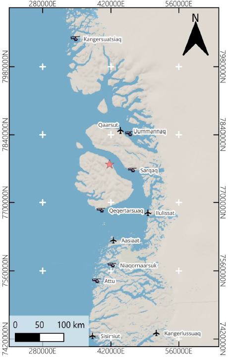
International access to West Greenland is typically via scheduled commercial flights to Nuuk or Ilulissat. From these hubs, fixed-wing domestic flights connect to Qaarsut (70 km northeast) or Aasiaat (170 km south) airports, depending on service schedule Figure 4-1.
Access by boat from via the Vaigat Strait is permissible for nine months of the year and requires an ice-strengthened vessel. There is a ferry to Disko Island which operates during summer requiring advance booking, and Air Greenland operate commercial helicopter flights between Ilulissat/Aasiaat and Qeqertarsuaq on the south side of the island.
| SRK EXPLORATION LIMITED ■ JUNE 2026 | 13 |
| Technical Report Summary for the Disko-Nuussuaq Project |
| ACCESSIBILITY, CLIMATE, LOCAL RESOURCES, INFRASTRUCTURE AND PHYSIOGRAPHY |
Figure 4-1: Regional access to the project
Sources: SRK EX, 2026
Notes: Star marks approximate location of the Disko-Nuussuaq Project camp
| 4.1.2 | Local Access |
Local access to the licence areas is by Air Greenland helicopter from various heliports in the vicinity including Qaarsut, Uummannaq (75 km northeast), Sarqaq (70 km east), Qeqertarsuaq (100 km south) and Ilulissat (120 km southeast). There are no roads to or within the project area.
Inside the licence areas, movement is constrained due to the absence of developed tracks/raids and by severe topography.
| SRK EXPLORATION LIMITED ■ JUNE 2026 | 14 |
| Technical Report Summary for the Disko-Nuussuaq Project |
| ACCESSIBILITY, CLIMATE, LOCAL RESOURCES, INFRASTRUCTURE AND PHYSIOGRAPHY |
| 4.2 | Climate |
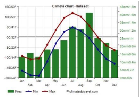
The Project lies in an Arctic maritime climate typical of west Greenland. An ice cap climate is present in the centre of Disko Island. Winters are long and cold, with mean monthly temperatures well below 0 °C and minimum temperatures commonly falling below -20 °C. Summers are short and cool; average temperatures in July can reach over 5°C. Climate data are available for the regional hub Ilulissat and shown in Figure 4-2.
Figure 4-2: Annual climate data for Ilulissat
Sources: climatestotravel.com
Precipitation occurs throughout the year, mostly falling as snow from late autumn through to spring, while rain and mixed precipitation are more common during the summer months. Fog, low cloud and blowing snow are frequent, and these conditions can significantly affect both aviation and marine operations. The area is sea ice free for 9 months of the year, with sea ice being more common in late winter and early spring, which may restrict marine access.
Daylight conditions are highly seasonal, ranging from very short days in mid-winter to continuous daylight in mid-summer, and this must be taken into account in planning and scheduling exploration activities.
| 4.3 | Local Resources and Infrastructure |
There is little infrastructure available to the project and all materials need to be transported in. The abandoned town of Qullissat on the northeast coast of Disko Island is the site of 80 Mile’s exploration camp during field campaigns, and remote field work is often either helicopter-based or uses short-term fly camps.
| SRK EXPLORATION LIMITED ■ JUNE 2026 | 15 |
| Technical Report Summary for the Disko-Nuussuaq Project |
| ACCESSIBILITY, CLIMATE, LOCAL RESOURCES, INFRASTRUCTURE AND PHYSIOGRAPHY |
| 4.3.1 | Settlements and Workforce |
The nearest population and service centres are coastal towns and settlements along the west coast of Greenland, particularly Qeqertarsuaq (on Disko Island itself; pop. 800), Ilulissat (pop. 5,150), and Uummannaq (pop. 1,380), which can provide local labour, boat services and limited supplies There are no permanent settlements within any of the licence areas. The history of coal mining in the area has left several previous settlements, particularly at Qullissat, on the island.
Goods and provisions can be sourced from the main towns Ilulissat, Aasiaat, and Uummannaq. Technical supplies require import via air or sea, and container vessels can dock these towns. These towns include shops, guesthouses, and small hospitals/health clinics.
| 4.3.2 | Power and Water |
There is no grid power in the area. Exploration at this stage requires off-grid power sources, likely diesel generators
Water for the area and drilling would likely be obtained from local stream sources, snow melt and ice cap runoff within the licence areas, subject to appropriate treatment and permitting.
| 4.4 | Physiography |
The physiography of Disko Island and the Nuussuaq Peninsula comprises basalt plateaus incised by U-shaped glacial valleys, fjords and narrow coastal plains. Peaks rise to over 1,500 m and remain covered by snow, ice and glaciers throughout the year.
There has been no systematic mapping of the permafrost or permafrost-related terrain features in this part of West Greenland, although Disko Island has been placed in a zone of continuous permafrost as supported by the open system pingos and numerous rock glaciers.
| SRK EXPLORATION LIMITED ■ JUNE 2026 | 16 |
| Technical Report Summary for the Disko-Nuussuaq Project |
| ACCESSIBILITY, CLIMATE, LOCAL RESOURCES, INFRASTRUCTURE AND PHYSIOGRAPHY |
Figure 4-3: Typical landscape and vegetation across the Disko Project area
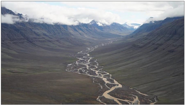
Sources: 80 Mile plc, 2025
Notes: Aaffarsuaq Valley
| SRK EXPLORATION LIMITED ■ JUNE 2026 | 17 |
| Technical Report Summary for the Disko-Nuussuaq Project |
| ACCESSIBILITY, CLIMATE, LOCAL RESOURCES, INFRASTRUCTURE AND PHYSIOGRAPHY |
Figure 4-4: Typical landscape and vegetation across the Disko Project area
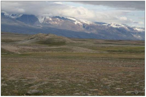
Sources: Hy-Grade Geoscience, 2007
| SRK EXPLORATION LIMITED ■ JUNE 2026 | 18 |
| Technical Report Summary for the Disko-Nuussuaq Project |
| HISTORY |
| 5 | HISTORY |
The Disko-Nuussuaq Project has been explored since the late 19th century, progressing from early prospecting of shallow mineral occurrences to modern exploration programmes over the past forty years that have targeted deeper parts of the magmatic system. Several organisations have contributed to advancing the project to its current stage of exploration. This section is summarised from Avannaa’s technical report and related documents and condensed into Table 5-1. Areas investigated are generally referenced by local place names, summarised in Figure 5-1.
| Table 5-1: | Summary of historical exploration on the Disko-Nuussuaq project |
| Year | Company/Entity | Area | Activity | Comments | ||
| 1870–1931 | Fritz Jørgensen, K.J.V. Steenstrup and A.B. Nordenskiӧld, | Igdlukunguaq | § | Prospecting | § | 28 t boulder @ 6.9% Ni, 3.7% Cu, 0.6% Co and 2 g/t PGM, excavated. |
| 1962–1963 | Inco and Kryoliteselskabet Oresund A/S Company | Unknown | § | Preliminary evaluations of Ni potential | ||
| § | Mapping and prospecting | |||||
| 1966 | New Quebec Mining and Exploration Company | Igdlukunguaq and Sarqaq Valley | § | Airborne magnetic and EM geophysics | ||
| 1968 | Terratest AB | Igdlukunguaq | § | Ground EM geophysics | § | Extended outcropping mineralisation anomaly to east by 500 m |
| 1970 | E.A. Hart | Igdlukunguaq | § | EM16 Very Low Frequency geophysics survey | § | Only one drillhole intersected the dyke. |
| § | 4 diamond drill holes | |||||
| 1985–1990 | Cominco and Greenex | Multiple unknown licences | § | Aeromagnetic geophysics | Identified: | |
| § | Ground reconnaissance | § | Similarities with Noril’sk | |||
| § | VLF EM geophysics | § | 18 EM anomalies | |||
| § | Time domain EM geophysics | § | 2 undiscovered native iron occurrences | |||
| § | Gravity surveying | § | Several contaminated lava flows. | |||
| § | Prospecting | |||||
| § | Grab, soil and stream sediment geochemistry | |||||
| SRK EXPLORATION LIMITED ■ JUNE 2026 | 19 |
| Technical Report Summary for the Disko-Nuussuaq Project |
| HISTORY |
| Year | Company/Entity | Area | Activity | Comments | ||
| 1991 | Falconbridge Exploration Ltd and Platinova Resources Ltd | Multiple unknown licences | § | Geological mapping | § | 30 stratigraphic sections constructed |
| § | Prospecting | |||||
| § | Lithogeochemical sampling of lavas. | |||||
| 1992 | Geoterrex Ltd, Falconbridge Greenland A/S and Platinova A/S | Itilli Valley, Aaffarsuaq Valley, Serfat, Sarqaq, Igdlukunguaq and Kuugannguaq Valley. | § | Airborne magnetic and GEOTEM EM survey over 11 areas. | § | Numerous AEM responses followed up with ground investigations. |
| § | Geological mapping, Lithogeochemical sampling, stream sediment sampling for PGE potential. | § | 7 areas warranted for ground geophysics and drill targets. | |||
| 1993 | Falconbridge Greenland A/S and Platinova A/S | Igdlukunguaq, Qullissat, Kuugannguaq Valley. | § | 10 drillholes in 2 separate areas | § | Drilling not maximised due to poor ground conditions. |
| § | Geological mapping | |||||
| § | Ground geophysics | |||||
| § | Lithogeochemical sampling | |||||
| 1994 | Falconbridge Greenland A/S and Platinova A/S | Qullissat, Kuugannguaq Valley, Itilli Valley, Serfat, Sarqaq Valley | § | Ground geophysics | Geophysical targets intersected with drilling. | |
| § | 17 drillholes in 4 separate areas | |||||
| § | Geological mapping | |||||
| § | Prospecting | |||||
| 1996 | Falconbridge Greenland A/S | Igdlukunguaq | § | Ground EM and magnetic surveys over dyke | Dyke conductors could not be traced further east. | |
| 1993–1996 | grønArctic Energy Inc | Aaffarsuaq | § | Onshore petroleum exploration drilling | Confirmed a shallow oil-prone source and deeper, pressurised gas-prone source. | |
| 1997–2000 | Greenland Geological Survey | Vaigat Strait | § | EM and magnetic geophysics | ||
| § | Seismic surveying | |||||
| SRK EXPLORATION LIMITED ■ JUNE 2026 | 20 |
| Technical Report Summary for the Disko-Nuussuaq Project |
| HISTORY |
| Year | Company/Entity | Area | Activity | Comments | ||
| 2003–2007 | Vismand Exploration | Kuugannguaq Valley, Igdlukunguaq, Aaffarsuaq Valley, Qullissat. | § | Titan-24 magnetotelluric (MT) geophysical surveys | § | Identified significant MT anomalies at depths of 500 to 1200 m. |
| § | 3 diamond drillholes in the Aaffarsuaq Valley | § | Drilling unsuccessful | |||
| 2012–2015 | Avanna Resources | Kuugannguaq Valley | § | ZTEM and aeromagnetic geophysics | § | Conductive structures identified. |
| § | Pilot seismic study and vibro-seismic survey | § | Various intrusions identified. | |||
| 2013–2014 | Coastal Ventures A/S | Qullissat and Igdlukunguaq | § | Coal exploration drilling over 7 drillholes | § | Coal prospectivity low. |
Sources: SRK EX, 2026.
| SRK EXPLORATION LIMITED ■ JUNE 2026 | 21 |
| Technical Report Summary for the Disko-Nuussuaq Project |
| HISTORY |
Figure 5-1: Place names as referenced in historical works (red outlines are licences belonging to Nikkeli A/S)
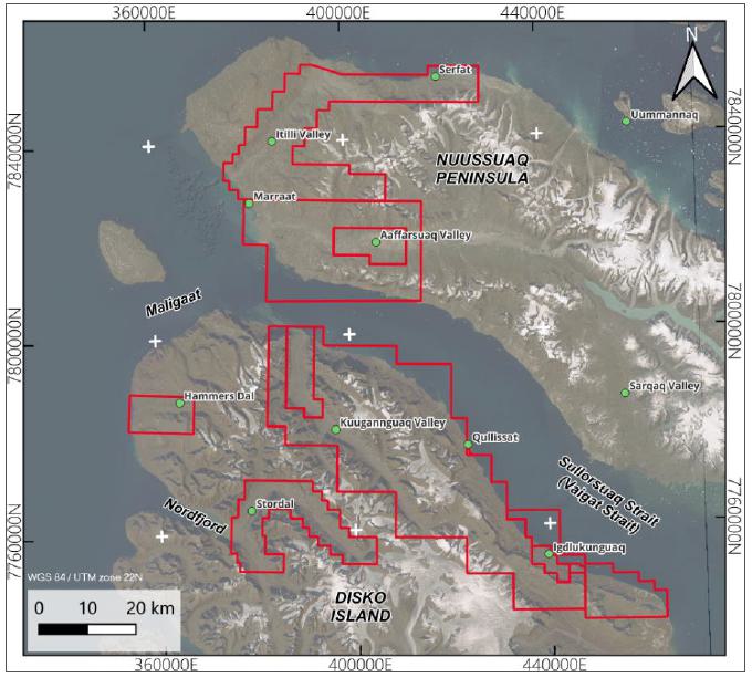
Sources: SRK EX, 2026
| 5.1 | Early Prospecting: 1870–1970 |
Greenlandic and Danish geologists, Fritz Jørgensen, K.J.V. Steenstrup and A.B. Nordenskiӧld, initially explored the area in the 1870s to collect information on native iron and coal seams. A small coal quarry was observed on the northeast coast of Disko Island, operational in the late 1700s. During this visit, geologists reportedly discovered a 28 tonne boulder of massive nickel sulphide associated with a dyke at Igdlukunguaq containing pyrrhotite and native iron.
Prospecting work was carried out until 1931 during which local prospectors from Qullissat extracted the massive nickel sulphide boulder from the Igdlukunguaq Dyke, assaying 6.9% Ni, 3.7% Cu, 0.6% Co and 2 g/t PGM (Bluejay Mining, 2022).
| SRK EXPLORATION LIMITED ■ JUNE 2026 | 22 |
| Technical Report Summary for the Disko-Nuussuaq Project |
| HISTORY |
Several studies of the metal occurrences have been published since 1950. Pedersen and Ulff-Moller were renowned for their work on flood basalts and have been credited with the discovery of several native iron occurrences.
Preliminary evaluations of the nickel potential in iron cumulates at the base of the mafic lava flows were carried out by Inco, while geological mapping and prospecting were undertaken by Kryoliteselskabet Øresund A/S in 1962–1963.
Further work on the Illukunnguaq Dyke continued in 1966 by the New Quebec Mining and Exploration Company on behalf of Lockwood Survey Corporation Limited. This work involved helicopter-based airborne magnetic and electromagnetic (“EM”) surveys over the Illukunnguaq area and a portion of the Sarqaq valley on the Nuussuaq Peninsula north of Disko Island. Additional geophysical surveys were conducted by Terratest AB in 1968, which identified a 500 m deep anomaly to the east and along strike of the outcropping nickel sulphide mineralisation. An EM16 Very Low Frequency (“VLF”) electromagnetic survey and a four-hole diamond drill programme totalling 256 m was implemented by E.A. Hart in 1970 to intersect the sulphide-bearing dyke, but only one of these holes was successful in intersecting the dyke.
| 5.2 | Cominco: 1985–1990 |
In the 1980s, Cominco recognised distinct geological similarities between Greenland's basaltic provinces (particularly Disko Island and the Nuussuaq Peninsula) and the world-class Noril'sk-Talnakh nickel-copper-cobalt-PGE district in Russia.
Exploration by Greenex on behalf of Cominco commenced in 1985. This programme involved an aeromagnetic survey, ground reconnaissance, VLF, horizontal loop EM, time domain EM, gravity surveying, prospecting, rock analysis, soil geochemistry and analysis of the light fractions from stream sediment sampling. The programme identified 18 electromagnetic anomalies, two previously undiscovered native iron showings and several contaminated lava flows.
In 1987, Cominco conducted a survey that successfully identified occurrences of sulphides and native iron through the sampling of volcanic rocks.
| 5.3 | Falconbridge: 1991–1996 |
| 5.3.1 | Exploration in 1991 |
Falconbridge commenced exploration on Disko Island in 1991. Initial work began with geological mapping, prospecting and lithogeochemical sampling of lavas and subvolcanic intrusions, resulting in the collection of 770 whole rock and 33 assay samples. The main objective was to demonstrate the correlation between mineralisation and subvolcanic intrusions. Sampling confirms that the geochemistry of the lavas and sills suggested large concentrations of Ni, Cu, Co and PGE remain undiscovered. Thirty stratigraphic profiles were produced in 1992 by Olshefky.
| 5.3.2 | Exploration in 1992 and 1993 |
Geoterrex Ltd. was contracted to fly an airborne GEOTEM and magnetic survey over eleven areas on Disko Island and the Nuussuaq Peninsula in 1992 (Figure 5-2). The nickel and platinum group element (“PGE”) potential of the West Greenland basalt province was evaluated through geological mapping, lithogeochemical sampling, stream sediment sampling and prospecting during the same summer.
| SRK EXPLORATION LIMITED ■ JUNE 2026 | 23 |
| Technical Report Summary for the Disko-Nuussuaq Project |
| HISTORY |
Figure 5-2: Extent of airborne GEOTEM and magnetic surveys and their anomalies
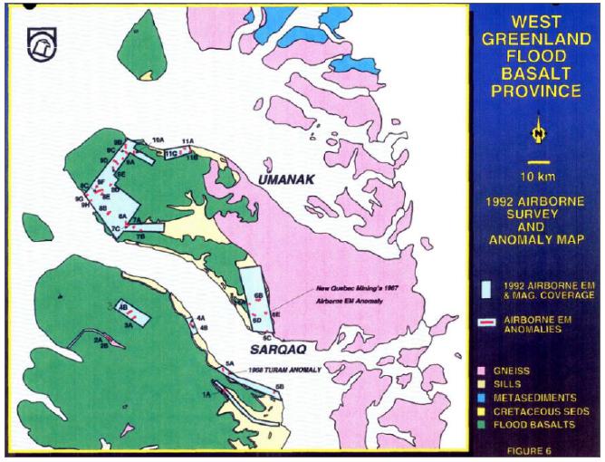
Sources: Olshefsky & Jerome, 1992.
Exploration activities in 1993 continued including ground geophysics, diamond drilling, geological mapping, lithogeochemical sampling and prospecting.
Reconnaissance mapping and sampling in the Kuugannguaq Valley was conducted. A total of 44 dyke samples and four sill samples were collected from Disko. Four nickel- copper-depleted dykes were identified close to the crater site in the Kuugannguaq Member. Pedersen, 1985, documented the crater site as an eruptive event producing 7.5 km3 of contaminated Ni-Cu depleted lavas and tuffs over an area of 200 km2. One dyke was correlated with the Kuugannguaq Member eruption event, while the remaining dykes were inferred to be feeder dykes to the Niagussat Member.
Drilling
Ten diamond drill holes totalling 921.1 m were completed in 1993 testing geophysical targets at Igdlukunguaq, Qullissat and in the Kuugannguaq Valley (Table 5-2). A Longyear Fly-in-38 drill rig was used and moved by helicopter. Drilling was focussed on the Igdlukunguaq Dyke area however planned target depths could not be reached due to complete loss of fluids from the poorly consolidated sediments. Drilling below the location of the sulphide boulder extracted sixty years prior confirmed the dyke does not continue down dip and is still interpreted to be open in a southeast direction at a 15° plunge (Stewart, 1992). Drilling was abandoned after one of the holes intersected a pocket of natural gas, causing a blowout.
| SRK EXPLORATION LIMITED ■ JUNE 2026 | 24 |
| Technical Report Summary for the Disko-Nuussuaq Project |
| HISTORY |
Only one hole, at Qullissat, encountered mineralisation FP93-4-1. The unit was interpreted as a sill, which contained a high proportion of finely disseminated graphite and minor pyrite and pyrrhotite. The intrusion is petrographically and geochemically similar to the volcanic rocks of the Asuk Member but with significantly higher levels of Ni (440 to 520 ppm) and Cu (240 to 700 ppm).
Drilling in the Kuugannguaq Valley intersected the magnetic gneissic basement confirming the source of the magnetic anomaly in this area.
Figure 5-3: Falconbridge drilling locations in the Qullissat, Igdlukunguaq, Kuugannguaq Valley and Sarqaq Valley areas
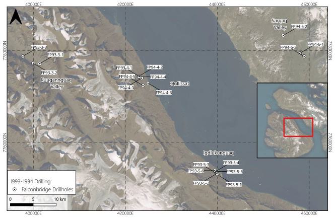
Sources: SRK EX, 2026
Notes: Hole IDs beginning FP93, corresponding to 1993 drillholes, FP94 as 1994 drillholes.
| SRK EXPLORATION LIMITED ■ JUNE 2026 | 25 |
| Technical Report Summary for the Disko-Nuussuaq Project |
| HISTORY |
Table 5-2: Summary of Falconbridge’s drilling in 1993
| Hole ID | Comment | Area | ||
| FP93-5-1 | Hole abandoned due to bad ground. Interbedded, porous quartzose sandstones and weakly conductive, carbonaceous shales. Broken coal seam from 31.9 to 35.0 m. | Igdlukunguaq | ||
| FP93-5-2 | Hole abandoned due to bad ground. Interbedded, porous quartzose sandstones and weakly conductive, carbonaceous shales. | Igdlukunguaq | ||
| FP93-5-3 | Hole abandoned due to bad ground. Interbedded, porous quartzose sandstones and weakly conductive, carbonaceous shales. Mafic intrusive from 38.3 to 40.8 m. | Igdlukunguaq | ||
| FP93-5-4 | Hole abandoned due to bad ground. Carbonaceous sandstones throughout. | Igdlukunguaq | ||
| FP93-5-5 | Hole abandoned due to bad ground. Interbedded carbonaceous' shales and porous quartzose sandstones. | Igdlukunguaq | ||
| FP93-5-6 | Interbedded carbonaceous shales and porous quartzose sandstones. Minor potential for downdip continuation of dyke. Hole abandoned due to bad ground. | Igdlukunguaq | ||
| FP93-4-1 | Mafic sill from 17.3 to 103.6 m having strongly conductive, graphitic fragments. | Qullissat | ||
| FP93-3-1 | Interbedded sandstones and weakly conductive, carbonaceous shales from. 44.8 to 97.2 m. Probable EM conductor is carbonaceous shale from 64.8 to 69.2 m. Gneissic basement (magnetic) encountered from 100.4 to 138.7 m. | Kuugannguaq | ||
| FP93-3-2 | Mafic volcanic flows from 14.8 to 31.2 m. Interbedded sandstones and weakly conductive carbonaceous shales from 31.2 m to EOH. Magnetic, subvertical, mafic dyke (135.0 to 152.9 m) with carbonaceous fragments causing EM response. | Kuugannguaq | ||
| FP93-3-3 | Vaigat Fm. picritic flows from 47.8 to 142.1 m including contaminated unit (119.5 to 142.1 m). High angle mafic intrusive from 142.1 to 151.7 m with strongly conductive graphitic fragments causing EM response. | Kuugannguaq |
Sources: Edited from AMEC Foster Wheeler, 2015
| 5.3.3 | Exploration in 1994 |
The 1994 Falconbridge exploration programme included ground geophysical surveys, diamond drilling and geological mapping and prospecting (Figure 5-4). Four geophysical grids extended across 151 km along four grids. Geophysical surveys included magnetics, gravity, TEM and horizontal loop EM. These geophysical grids were designed to investigate the Ni-Cu enriched intrusion and airborne EM anomaly located in the Qullissat area on Disko Island.
| SRK EXPLORATION LIMITED ■ JUNE 2026 | 26 |
| Technical Report Summary for the Disko-Nuussuaq Project |
| HISTORY |
Figure 5-4: Exploration summary, Falconbridge 1994
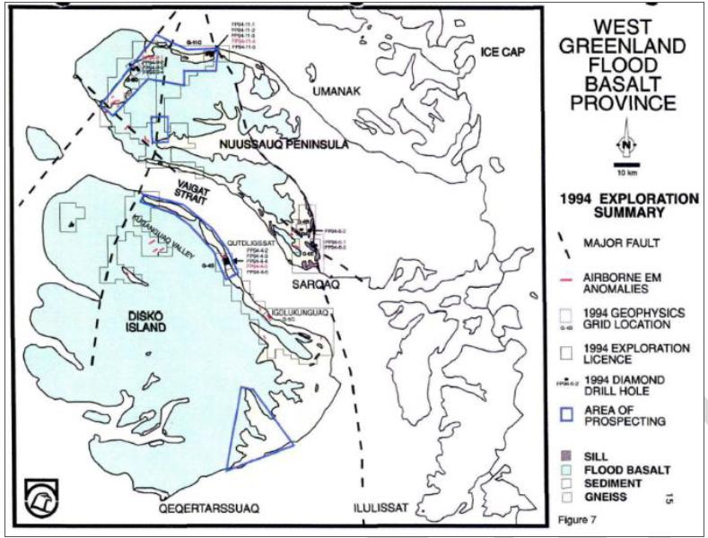
Sources: Olshefsky et al, 1995.
| SRK EXPLORATION LIMITED ■ JUNE 2026 | 27 |
| Technical Report Summary for the Disko-Nuussuaq Project |
| HISTORY |
Several dykes were sampled in the region between the coastal section at Qullissat and the Kuugannguaq valley. Most samples returned normal levels of Ni and Cu. Two dykes had depleted levels of Ni and Cu; these occurred in close proximity to the Kuugannguaq Member eruption site.
Drilling
Seventeen diamond drill holes totalling 3,145.74 m tested new geophysical targets related to sill and dyke subvolcanic intrusives at Serfat, the Itilli Valley (Figure 5-5), and the Sarqaq Valley and continued investigations at Qullissat (Figure 5-6). Falconbridge acquired another Longyear Fly-in-38 rig for the 1994 season.
Drilling in the Serfat area was designed to test several magnetic, gravity and EM features of the Serfat Sill Complex (Table 5-3). Three holes identified a large intrusive complex of picrite and quartz dolerite confirming the source of the geophysical targets. These holes also intersected underlying sedimentary units and gas-rich carbonaceous units. Two of the holes intersected a large thickness of overburden and were abandoned at shallow depths.
Table 5-3: Summary of drilling the Serfat area
| Hole ID | Target | Intersected | Depth Reached/Outcome | |||
| FP94-11-01 | Weak Max-Min EM anomaly coincident with a gravity high and edge of magnetic high | Thick overburden with numerous, variably sized gneissic and mafic boulders; no bedrock | 51.2 m; abandoned in overburden due to stuck rods | |||
| FP94-11-02 | Gravity high coincident with weak Max-Min EM anomaly (airborne anomaly 11C) | 73.5 to 212.9 m: thick quartz dolerite unit; 88.8 to 111.9 m: picritic sill; below sill: siltstones & carbonaceous siltstones; 232.8 to 245.9 m: grey, fine-grained, weak–moderately magnetic mafic dyke | 422.8 m; terminated after rods repeatedly jammed | |||
| FP94-11-03 | Strong magnetic high adjacent to south edge of a gravity high | Overburden only; unable to penetrate to bedrock | 31.1 m; abandoned in overburden | |||
| FP94-11-04 | Gravity high adjacent to an interpreted fault; on exposure of picrite intrusion | 3.8 to 16.6 m: picrite intrusion; 16.6 to 105.8 m: quartz dolerite intrusion with minor pyrite (+pyrrhotite?); 105.8 to 340.5 m: sandstones and carbonaceous siltstones; 286.0 to 294.0 m: pressurised gas seam in carbonaceous siltstone | 340.5 m; ended due to intersection of a pressurised gas seam; intrusive bodies explain the gravity high | |||
| FP94-11-05 | Gravity high beside an interpreted fault | 10.0 to 31.1 m: blocky, fine–medium grained, weakly magnetic picrite sill beneath overburden; between sill and quartz dolerite: interlayered siltstone and carbonaceous siltstone; 92.6 to 203.6 m: quartz dolerite sill | Depth not fully specified; known intersections from 10.0 to 203.6 m, including picrite and quartz dolerite sills |
Sources: Edited from Amec Foster Wheeler, 2015
Four holes were completed in the Itilli Valley area (Table 5-4) to intersect EM trends and test for Ni-Cu mineralisation within the Maligât and Vaigat mafic sill and dyke units. No indications of massive or economic Ni-Cu bearing sulphide zones were intersected. The drilling identified fault gouge, pyritic bands and weathering horizons corresponding to the EM anomalies.
| SRK EXPLORATION LIMITED ■ JUNE 2026 | 28 |
| Technical Report Summary for the Disko-Nuussuaq Project |
| HISTORY |
Table 5-4: Summary of Falconbridge drilling in the Itilli Valley area
| Hole ID | Target | Intersected | Depth Reach/Outcome | |||
| FP94-9-1 | Low-level EM response (N–S, ~1 km strike) coincident with magnetic low | Sequence of carbonaceous siltstone and sandstone, intruded by multiple fine-grained mafic sills (0.5 to 3.3 m thick); >15 m Ti-rich, feldspar-phyric Maligât sill at bottom with normal Cu-Ni levels; water-filled gouge zones parallel to bedding (weakly conductive); pyritic bands (2 to 5 mm, parallel to bedding) at 86.5 to 94.5 m and 472.2 to 522.1 m, spatially associated with mafic sills and forming conductive sheets | 537.1 m; bottomed in thick Maligât sill; EM response explained by conductive pyritic bands and water-filled gouge zones parallel to bedding | |||
| FP94-9-2 | Low-level NW–SE EM trend and elevated magnetic signature | Intercalated mafic volcanic and volcaniclastic sedimentary rocks of Maligât origin forming five volcanic cycles; 8.0 to 46.9 m: mafic flow; each cycle (except the 8 to 46.9 m flow) contains a 3 to 4 m thick, deeply weathered saprolite horizon (gossanous yellow-brown to red, haematitic) that crumbled during drilling | 127.0 m; terminated early due to collapse of fractured wallrock; weak EM conductor interpreted as water-saturated saprolitic horizons | |||
| FP94-9-3 | Stratigraphic test and to test EM response | Intercalated high-Ti mafic volcanic and volcaniclastic sedimentary rocks; three volcanic cycles logged (fewer than in FP94-9-2); deep post-depositional weathering with saprolitic zones | 97.5 m; terminated early due to drilling problems (planned 500 m); weak EM conductor attributed to water-permeated saprolitic zones; magnetic signature from magnetic volcanics | |||
| FP94-9-4 | Weak Max-Min EM response | 0 to 138.1 m: hyaloclastite breccia; 23.4 to 30.2 m: intercalated 6.8 m carbonaceous siltstone; faulted contact at base with carbonaceous siltstone and sandstone; carbonaceous sediment intruded by grey-green, magnetic, generally aphyric mafic sills/dykes (three Maligât, one Vaigat: 157.8 to 163.4 m); carbonaceous sediment adjacent to intrusives hosts 0.5 to 1 cm concordant pyrite bands and ovoids (notably 152.5 to 153.8 m and 171.6 to 175.0 m) | 180.2 m; stopped at fault in mafic intrusive; weak EM conductor explained by hydrated fault gouge (10 to 20 cm wide) within carbonaceous siltstone at 23.4 to 30.2 m |
Sources: Edited from Amec Foster Wheeler, 2015
| SRK EXPLORATION LIMITED ■ JUNE 2026 | 29 |
| Technical Report Summary for the Disko-Nuussuaq Project |
| HISTORY |
Figure 5-5: Falconbridge drilling 1994 in the Serfat and Itilli Valley areas
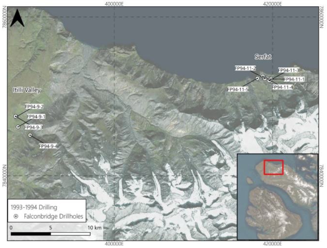
Sources: SRK EX 2026
Drilling at Qullissat aimed to follow on from the elevated Ni and Cu values intersected in the 1993 hole and define the geometry of the Ni-Cu enriched Qullissat sill. The drilling confirmed carbonaceous Cretaceous sediments intruded by several mafic sills, most notably the Qullissat sill (Table 5-5). This sill however returned low grades for Ni and Cu and no significant sulphide accumulations. The pyrrhotite-bearing iron cumulate zone intersected at the base of the Qullissat sill displays sporadic, micron-scale gold with Au grades reaching 14.8 g/t in the magnetic fraction separated from this material.
Table 5-5: Summary of drilling in the Qullissat area
| Hole ID | Target | Intersected | Depth Reach/Outcome | |||
| FP94-4-2 | Strong negative magnetic anomaly within Cretaceous sedimentary rocks | Overburden to 42.52 m; 42.52 m: fine-grained, weakly magnetic, feldspar-phyric basaltic sill (Vaigat); 44.27 to 51.12 m: mafic fragmental unit; 51.12 to 69.20 m: second mafic sill | 69.20 m; terminated due to extreme lost circulation caused by large open fractures in sill |
| SRK EXPLORATION LIMITED ■ JUNE 2026 | 30 |
| Technical Report Summary for the Disko-Nuussuaq Project |
| HISTORY |
| Hole ID | Target | Intersected | Depth Reach/Outcome | |||
| FP94-4-3 | NW–SE magnetic low, interpreted extension of 1993 Ni–Cu enriched sill; objectives: explain magnetic low, test basal Qullissat sill for Ni–Cu sulphides, and check for deeper sills | 32.5 to 58.2 m: grey, fine-grained, equigranular, massive, aphyric, strongly magnetic mafic sill | 58.2 m; abandoned due to drilling difficulties | |||
| FP94-4-4 | Same target area as FP94-4-2 (strong magnetic feature in Cretaceous succession) | Carbonaceous siltstone; upper mafic sill; mafic volcaniclastic rocks; terminated in a graphite-bearing, Ni–Cu enriched sill | 61.60 m; terminated due to extreme water loss in blocky mafic sill | |||
| FP94-4-5 | Basal area of Qullissat sill for Ni–Cu sulphide accumulations; coincident magnetic low, airborne EM, and ground TEM anomaly | Above sill: 50.2 m carbonaceous siltstone and sandstone; Qullissat sill (first full penetration, contains elevated Ni and Cu); below sill: intercalated carbonaceous siltstone, sandstone and coal; basal Qullissat sill 177.4 to 190.5 m: native iron cumulate with 0.5 to 2 mm droplets, 0 to 5% modal, best 2 to 5% from 188.3 to 190.5 m; assays show low Ni, Cu, Co, Pt, Pd, Fe but anomalous Au up to 14.8 g/t in magnetic fraction | 270.5 m; fully drilled through Qullissat sill into footwall; target explained by Ni–Cu–bearing sill and associated native iron cumulate with anomalous gold | |||
| FP94-4-6 | Magnetic low 200 m north of an exposed basaltic sill | Interbedded quartzose sandstone, carbonaceous siltstone and coal; no sill intersected | 143.26 m; completed in sedimentary sequence with no basaltic sill encountered |
Sources: Edited from Amec Foster Wheeler, 2015
Drilling in the Sarqaq Valley targeted EM anomalies and a corresponding ring-like dyke feature exposed on surface. The drilling confirmed poorly lithified Cretaceous sedimentary lithologies with limited mafic intrusions (Table 5-6). No significant Ni-Cu bearing sulphides were intersected. Two gabbroic dykes were intersected in one drillhole but Ni-Cu grades were not enriched.
Table 5-6: Summary of drilling the Sarqaq Valley area
| Hole ID | Target | Intersected | Depth Reach/Outcome | |||
| FP94-6-1 | Strong, complex Max-Min EM anomaly west of magnetically inferred Boundary Fault; stratigraphic test for Ni-sulphide intrusions to 500 m | Overburden with moderately conductive pre-glacial saltmarsh mud directly on Cretaceous sediment; 44.02 to 48.93 m: intercalated carbonaceous siltstone and sandstone; 48.93 to 85.34 m: non-lithified quartzose sandstone | 85.34 m; terminated after rods sheared while trying to pass a 7.93 m open cavity; EM response attributed to saltmarsh mud | |||
| FP94-6-2 | Angle hole (175° / -50°) to test 1993 Max-Min EM Anomaly C coincident with exposed mafic dyke | Thick sequence of intercalated carbonaceous sandstone and siltstone; 101.20 to 107.40 m: carbonaceous siltstone explaining EM Anomaly C; 107.4 to 120.2 m: 13 m grey–green, fine–medium grained, magnetic, aphyric gabbroic dyke (Dyke 1); 124.9 to 203.8 m: 79 m dark green, medium grained, strongly magnetic, equigranular gabbroic dyke (Dyke 2); both dykes carry normal Ni–Cu grades | 266.8 m; stopped after penetrating EM target and mafic dyke |
| SRK EXPLORATION LIMITED ■ JUNE 2026 | 31 |
| Technical Report Summary for the Disko-Nuussuaq Project |
| HISTORY |
| Hole ID | Target | Intersected | Depth Reached/Outcome | |||
| FP94-6-3 | Strong airborne and Max-Min EM responses east of Boundary Fault | 172.82 m; terminated due to poorly lithified sediment; | 172.82 m; terminated due to poorly lithified sediment; EM anomaly explained by conductive saltmarsh mud above bedrock |
Sources: Edited from Amec Foster Wheeler, 2015
Figure 5-6: Falconbridge drilling 1994 in the Qullissat and Sarqaq Valley areas
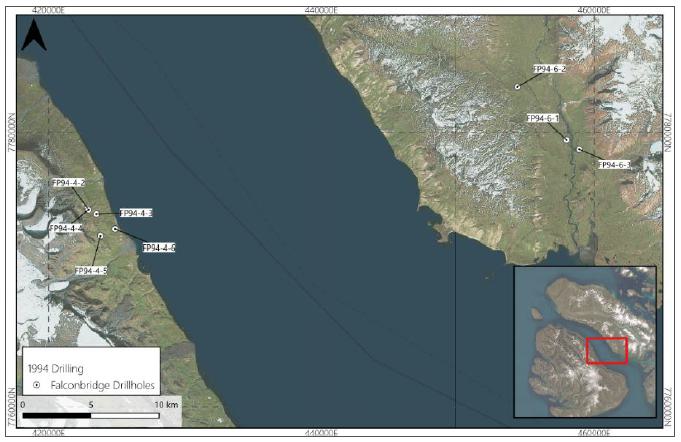
Sources: SRK EX, 2026
Sampling of the Falconbridge drill core in 1994 involved whole rock sampling collecting several pieces of core 5 to 10 cm in length over a 1 m interval. Samples were shipped to Lakefield Research Analytical Services in Lakeland, Ontario at the end of the field programme and analysed for eleven major oxides and As, Ba, Nb, Rb, Sr, Y, Zr, Zn, Ni, Co and S. Standards were submitted alongside the samples.
| 5.3.4 | Exploration in 1996 |
The 1996 exploration programme included ground time-domain EM and magnetic surveys in the Igdlukunguaq area. The aim of this was to determine the eastern extent of an EM conductor identified in 1993 and to investigate the mineralised area of the Igdlukunguaq dyke. Conductors associated with the dyke could not be traced further east as continuous features, although intermittent conductive zones were found along strike indicating that the dyke may be disrupted by faulting or later intrusions.
| SRK EXPLORATION LIMITED ■ JUNE 2026 | 32 |
| Technical Report Summary for the Disko-Nuussuaq Project |
| HISTORY |
Technical issues associated with the drilling operations caused Falconbridge to cease exploration efforts at Disko.
| 5.4 | grønArctic Energy Inc: 1993–1996 |
While Falconbridge was exploring in the area, grønArctic Energy Inc. owned a licence covering the Aaffarsuaq Valley and the southwest coast of the Nuussuaq Peninsula. Their aim was primarily to investigate the potential of the Cretaceous-Palaeocene volcanic and sedimentary stratigraphy for hydrocarbons, and to evaluate the feasibility of drilling for onshore petroleum deposits. A total of eight holes were drilled using wireline diamond drilling core rigs, including one to the north of the peninsula in the Tunorsuaq Valley (Figure 5-7).
Drilling confirmed the presence of a petroleum system with a shallow oil-prone source and deeper, pressurised gas-prone source. Mechanical and pressure problems experienced during this drilling caused grønArctic to cease exploration. Their observations, summarised below, are however useful in informing future exploration on the Nuussuaq Peninsula.
| SRK EXPLORATION LIMITED ■ JUNE 2026 | 33 |
| Technical Report Summary for the Disko-Nuussuaq Project |
| HISTORY |
Figure 5-7: grønArctic drilling on the Nuussuaq Peninsula, 1993 – 1996
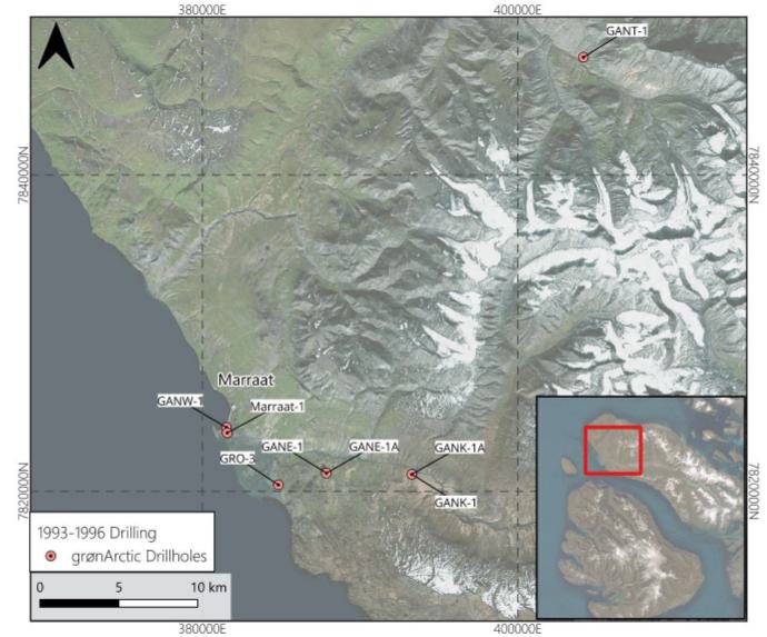
Sources: SRK EX, 2026
Notes: 1993 (Marraat-1), 1994 (GANW-1), 1995 (GANE-1, GANE-1A, GANK-1, GANK-1A, GANT-1), 1996 (GRO-3).
1Holes labelled with suffix ‘A’ are drilled side-track holes.
| SRK EXPLORATION LIMITED ■ JUNE 2026 | 34 |
| Technical Report Summary for the Disko-Nuussuaq Project |
| HISTORY |
Figure 5-8: grønArctic Marraat-1 drill hole set up
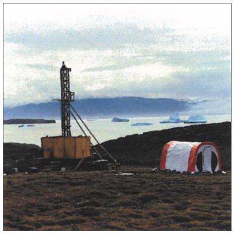
Sources: Dam & Christiansen, 1994.
Drillhole GANW-1 drilled roughly 800 m of Vaigat Formation lavas (Anaanaa Member) without reaching the underlying sedimentary sequence. GANE-1 was drilled to 641 m, with about the upper 500 m in Anaanaa volcanics and around 150 m of underlying sandstones and mudstones, while the sidetrack GANE-1A intersected sediments between 533 and 707 m and cut a 7 m picrite sheet near 690 m. At GANK-1, Vaigat lavas of the Naujánguit and Anaanaa members were drilled to 115 m, below which sediments continued down to 399 m; the GANK-1A sidetrack encountered sediments from about 219 to 333 m, plus several intrusions, among them an approximately 10 m thick dolerite sheet at about 340 m.
GANT-1 drilled approximately 900 m with the main recovered lithology being clastic sediments cut by 14 thin volcanic units. GRO-3 was grønArctic’s deepest hole reaching almost 3,000 m. The top 300 m comprised volcanic rocks overlying a thick sedimentary succession of sandstones, mudstones/shales and tuffaceous units, in which 39 igneous intrusions with a combined thickness of 145 m were recorded, most abundant between 500 and 650 m and including a thick body between roughly 2,625 and 2,650 m.
The Maarrat-1 drillhole (Figure 5-8) confirmed results from previous fieldwork, where porous basalt zones containing liquid oil down to a depth of 86 m were intersected.
Some of the operational problems encountered during this drilling included:
| § | GANK-1: Highly fractured sediments caused parting of rods and stuck core barrels; |
| SRK EXPLORATION LIMITED ■ JUNE 2026 | 35 |
| Technical Report Summary for the Disko-Nuussuaq Project |
| HISTORY |
| § | Marraat-1: Breaking of the bit and reamer at 447.75 m depth due to fractured lithologies meant the underlying formation was not drilled and drilling stopped early; |
| § | GANT-1 – High dry gas pressures at depth caused drill rods to repeatedly shear limiting deeper drilling. |
| § | GANE-1 – During pullout at 540 m rods became stuck, attempts of retrieval were unsuccessful. Multiple rod shearings from high gas pressures in the side-track well caused the hole to be abandoned at 707 m. |
Evidence of a hydrocarbon system were observed in multiple holes via gas burns in flair line, small bubbles of air/gas in drilling muds, however significant accumulations were not discovered.
Logging, sampling and analysis of the recovered drill core was tailored to hydrocarbon exploration including Leco/RockEval pyrolysis, vitrinite reflectance, gas chromatography, head space gas consumption and water geochemistry.
| 5.5 | Greenland Geological Survey: 1997–2000 |
Onshore and offshore exploration for minerals and oil was carried out by Sander Geophysics Ltd on behalf of the Geological Survey of Denmark and Greenland (“GEUS”), as part of the five-year airborne geophysical programme. This included the acquisition of EM and magnetic data.
In 2000, offshore seismic surveying was carried out in the Vaigat Strait and along the western and northern coasts of the Nuussuaq Peninsula by the Greenland Bureau of Minerals and Petroleum, in collaboration with the Danish Energy Research Programme, the Geological Institute at Aarhus University, GEUS.
| 5.6 | Vismand Exploration: 2003–2007 |
| 5.6.1 | Geophysical Surveys in 2003–2004 |
In 2003, Titan-24 magnetotelluric (“MT”) surveys were performed on traverses across the Kuugannguaq Valley, the Igdlukunguaq area in northwest Disko Island and the Aaffarsuaq Valley on the Nuussuaq Peninsula by Quantec Geoscience on behalf of Vismand Exploration (Figure 5-9). Further surveys were conducted in the Qullissat area and the coastal section between Kuugannguaq and Qullissat in 2004, and an additional survey was conducted perpendicular to the 2003 survey in Kuugannguaq.
| SRK EXPLORATION LIMITED ■ JUNE 2026 | 36 |
| Technical Report Summary for the Disko-Nuussuaq Project |
| HISTORY |
Figure 5-9: Quantec/Vismand MT survey areas, 2004
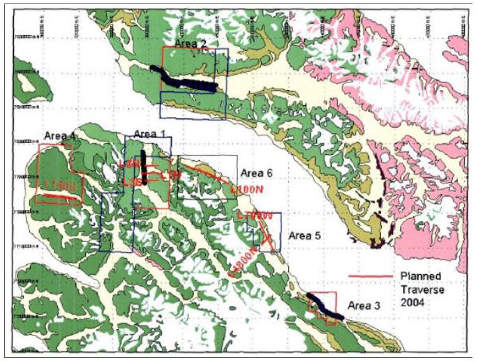
Sources: Quantec Geosciences, 2004
The 2003 survey identified significant MT responses in Kuugannguaq and Aaffarsuaq at depths of 500 to 1,200 m.
The 2004 traverses confirmed the presence of a N-S trending conductive anomaly in the Kuugannguaq valley. The top of the conductors was well defined at 700 m depth and estimated at a vertical to steep west dip. Two conductive features were identified in the Qullissat area. Only one feature could be defined in the coastal section between Kuugannguaq and Qullissat.
These surveys were later reprocessed by Quantec Geoscience on behalf of Bluejay mining in 2019 and later incorporated into KoBold’s work.
| 5.6.2 | Exploration Drilling in 2007 |
In 2007, Vismand drilled three holes on the Nuussuaq Peninsula (Figure 5-10) testing geophysical targets previously identified in 2003 and 2004 up to depths of 1200 m. Two gas incidents occurred however that ceased Vismand’s operations.
| SRK EXPLORATION LIMITED ■ JUNE 2026 | 37 |
| Technical Report Summary for the Disko-Nuussuaq Project |
| HISTORY |
Figure 5-10: Vismand drilling in the Aaffarsuaq valley on the Nuussuaq Peninsula, 2007
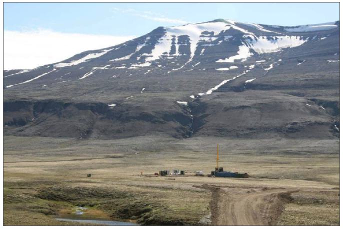
Sources: Hy-Grade Geoscience, 2007
Three holes (V-GRN-1, -1A and -2) were drilled by Vismand Exploration in the 2007 field season (Figure 5-11) in the Aaffarsuaq Valley using an air rotary rig to drill and case through the soft overburden and then a Longyear LDS 55 diamond drill rig to continue to depth (Figure 5-12). The rigs were transported overland via a ~30 km long road that Vismand constructed from the coast eastwards to the drilling area.
The deepest hole only reached a depth of 154.45 m, failing to reach bedrock due to thick overburden. All holes were all abandoned early due to the difficulty of drilling thick overburden and encountering overpressured gas-cut water. The drill strings and bottom hole assemblies for V-GRN-1 and V-GRN-2 were left in the holes. The planned drilling depths of 1,200 m were not achieved and Vismand’s targets remain untested.
| SRK EXPLORATION LIMITED ■ JUNE 2026 | 38 |
| Technical Report Summary for the Disko-Nuussuaq Project |
| HISTORY |
Figure 5-11: Vismand drill collar locations in the Aaffarsuaq Valley on the Nuussuaq Peninsula, 2007
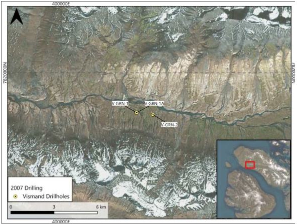
Sources: SRK EX, 2026
Notes: Holes labelled with suffix ‘A’ are drilled side-track holes.
| SRK EXPLORATION LIMITED ■ JUNE 2026 | 39 |
| Technical Report Summary for the Disko-Nuussuaq Project |
| HISTORY |
Figure 5-12: Diamond drill rig at V-GRN-1
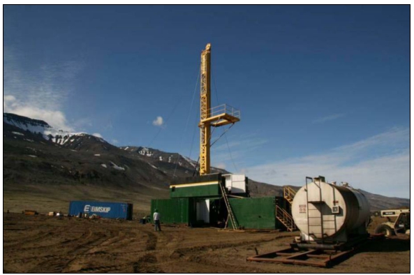
Sources: Hy-Grade Geoscience, 2007
| 5.7 | Avannaa Resources: 2012–2015 |
| 5.7.1 | Exploration in 2012 |
Avannaa Resources focused their 2012 field activities around the northern part of the Kuugannguaq Valley on Disko Island. In May 2012, a helicopter-borne Z-axis tipper electromagnetic (“ZTEM”) and aeromagnetic geophysical survey was completed in the licence area. This covered a total of 278 km2 (Figure 5-13). Several conductive structures were identified which correspond with the previous Titan-24 MT responses.
| SRK EXPLORATION LIMITED ■ JUNE 2026 | 40 |
| Technical Report Summary for the Disko-Nuussuaq Project |
| HISTORY |
Figure 5-13: Coverage map of 2012 ZTEM survey
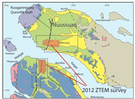
Sources: Avannaa Resources, 2014
In September 2012, a pilot seismic study was carried out along a 1,300 m N-S profile, with 96 channels, 3.7 m geophone spacing and 11.25 m source spacing. The source was NSP711 explosive detonated in a non-destructive blast at a depth of 80 to 130 cm.
| 5.7.2 | Exploration in 2013 |
Further to the pilot seismic study, a vibro-seismic survey was conducted in the Kuugannguaq Valley (Figure 5-14) in 2013 as well as a ground magnetic survey in the northern part of the Kuugannguaq Valley on Disko. A 3D inversion of the ZTEM data was performed by Mira Geoscience. Several distinct bodies were observed in the Kuugannguaq and Aaffarsuaq valleys. Additionally, a study into the feasibility of drilling was conducted by WellPerform and Ross Engineering.
Interpretation of the vibro-seismic data identified bodies that thought to be intrusions dipping in various directions beneath Kuugannguaq Valley (Figure 5-15, Clausen and Nørmark, 2014). These are bounded on the east by a westward dipping major fault and are generally elongated in a NW- SE direction; however, the western delineation is uncertain. The bodies interpreted to be intrusives are present at various depths, bound at the top by the base of the Recent sediments in the valley, but it was not possible to estimate their thickness or thickness variations. No intrusive sills were identified in the interpretation.
| SRK EXPLORATION LIMITED ■ JUNE 2026 | 41 |
| Technical Report Summary for the Disko-Nuussuaq Project |
| HISTORY |
Figure 5-14: Vibro-seismic lines in the Kuugannguaq Valley
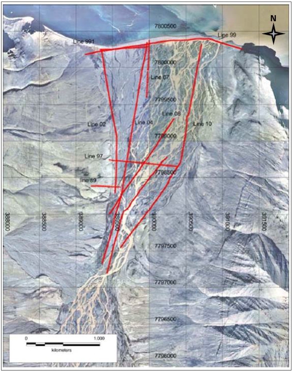
Sources: Avannaa Resources, 2014
| SRK EXPLORATION LIMITED ■ JUNE 2026 | 42 |
| Technical Report Summary for the Disko-Nuussuaq Project |
| HISTORY |
Figure 5-15: Seismic section from south to north through the Kuugannguaq Valley with interpreted intrusions (from Clausen and Nørmark, 2014)
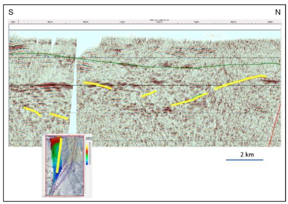
Sources: Avannaa Resources, 2014
AMEC (2014) concluded that locating mafic sills based only on the seismic data without additional knowledge of the lithologies in the area (coal beds, shales, conglomerates, etc.) and clear definition of polarity is a challenge. They recommended that identifying a conductor with a coincident strong seismic reflection might be the best targeting approach but noted that a conductor could be related to shales and/or carbonaceous units. AMEC also highlighted several limitations in the processing and interpretation of this seismic data which constrain the reliability of the data for targeting further exploration, including:
| ■ | The interpretation of a stacked section where no migration has been performed; |
| ■ | No mention of polarity; |
| ■ | No comparison to velocity models; |
| ■ | Short length of the line and limited offset of channel means that the ability to image steeper structures is significantly decreased; |
| ■ | No constraints from drilling; |
| ■ | Orientation of the lines are mostly N-S, with limited tie lines or E-W coverage. |
| SRK EXPLORATION LIMITED ■ JUNE 2026 | 43 |
| Technical Report Summary for the Disko-Nuussuaq Project |
| HISTORY |
| 5.7.3 | Exploration in 2014 |
Mira Geoscience continued modelling the magnetic data in Kuugannguaq and the Aaffarsuaq Valley to assist with drill targeting. Avannaa’s exploration efforts were finalised with a preliminary environmental evaluation and drill design study, but funding for this drilling was never secured and it did not go ahead.
| 5.8 | Coastal Ventures A/S: 2013–2014 |
While Avannaa were exploring at Disko, privately-owned Coastal Ventures A/S, undertook drilling and field reconnaissance activities on Disko between Qullissat and Igdlukunguaq, and on the Nuussuaq Peninsula west of the Sarqaq Valley. Their work targeted coal and non-coal resources.
| 5.8.1 | Drilling |
While an accompanying report of Coastal Ventures drilling programme in 2013 is not available, SRK EX has received scanned paper logs from two drillholes completed in the 2014 season, and collar coordinates and drilled depths for a further five holes completed in 2013 (Figure 5-16). There is little other information available for this drilling. Logs state that voids and issues with hole casing led to the early abandonment of CV-NUS-020 and CV-NUS-008 at depths of 336 m and 335 m, respectively. Results mention that less coal was discovered than originally presumed and only one coal seam was encountered in CV-NUS-020 (Figure 5-17).
| SRK EXPLORATION LIMITED ■ JUNE 2026 | 44 |
| Technical Report Summary for the Disko-Nuussuaq Project |
| HISTORY |
Figure 5-16: Coastal Ventures drilling on the Disko-Nuussuaq project 2013 - 2014
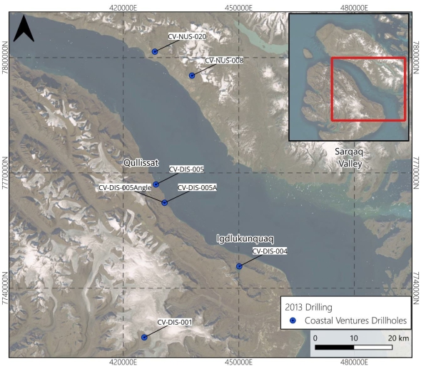
Sources: SRK EX, 2026
In early 2017, FinnAust Mining (subsequently rebranded as Bluejay Mining and now 80 Mile PLC) acquired Coastal Venture’s mineral exploration licences, which were subsequently renewed by the Greenland government.
| SRK EXPLORATION LIMITED ■ JUNE 2026 | 45 |
| Technical Report Summary for the Disko-Nuussuaq Project |
| HISTORY |
Figure 5-17: Coal intersected in hole CV-NUS-020
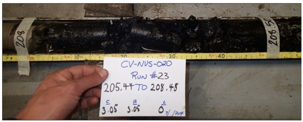
Sources: Coastal Ventures, 2014
Notes: CV-NUS-020, 208 – 208.50 m
| 5.9 | SRK EX Comments |
Historical exploration on Disko Island and the Nuussuaq Peninsula has been of value in increasing the geological understanding of this area and generated targets that are worth further investigation. Although none of the work identified direct evidence of magmatic nickel sulphide mineralisation, this is not a reflection of the area’s prospectivity; many targets were not tested properly due to a high rate of drillhole abandonment related to difficult ground conditions, loss of equipment in the holes, and the presence of over-pressured gas-cut water impacting the circulating drill fluids. Approximately 60% of all drillholes were either abandoned or terminated before the target depth.
| SRK EXPLORATION LIMITED ■ JUNE 2026 | 46 |
| Technical Report Summary for the Disko-Nuussuaq Project |
| GEOLOGICAL SETTING AND MINERALISATION |
| 6 | GEOLOGICAL SETTING AND MINERALISATION |
| 6.1 | Regional Geology |
The Disko-Nuussuaq Project is located on the central west coast of Greenland, within the West Greenland Igneous Province, part of the broader North Atlantic Igneous Province (“NAIP”). The region occupies the western margin of the Greenland Craton and records a geological history spanning Archean crustal formation, Mesozoic rifting, and extensive Palaeocene volcanism associated with the opening of the Labrador Sea and Baffin Bay (Figure 6-1).
The oldest rocks in the region comprise Archean to Paleoproterozoic (3.8 to 2.8 Ga) crystalline basement belonging to the Rae craton. These rocks consist predominately of gneisses, granitoids, metavolcanic rocks and associated supracrustal sequences that were subsequently reworked during the Paleoproterozoic tectonothermal events associated with the Nagssugtoqidian Orogen. These once mountainous belts were slowly eroded during a long period of tectonic stability, forming a relatively flat, low-lying continental plain (Ansulemi, 2009). The basement formed the foundation upon which younger sedimentary and volcanic successions were deposited.
During the Early to Late Cretaceous (145 to 130 Ma), regional extension associated with the progressive separation of Greenland from North America associated with the break-up of the supercontinent Pangea resulted in the formation of a series of fault-bounded sedimentary basins, referred to locally as the Nuussuaq basin. Sea floor spreading initiated in the south at 70 Ma, propagating north through the Davis Strait into Baffin Bay by 60 Ma. These basins accumulated several kilometres of fluvial, deltaic, and shallow marine sedimentary rocks comprising sandstones, mudstones, carbonaceous shales and coal-bearing units. Basin development was controlled by major normal fault systems and transfer structures that established the structural architecture subsequently exploited by ascending magmas during Palaeocene volcanism.
Continued lithospheric extension culminated during the Palaeocene with the onset of voluminous magmatism associated with the North Atlantic Igneous Province. Volcanic activity between approximately 62 and 58 Ma generated extensive flood basalt sequences preserved across Disko Island, the Nuussuaq Peninsula and adjacent offshore areas. The volcanic succession is traditionally subdivided into the Vaigat, Maligât, Svartenhuk and younger volcanic formations, with the Vaigat Formation comprising high-MgO picritic and basaltic magmas and the Maligât Formation representing the main phase of tholeiitic flood basalt volcanism. The combined volcanic volume is estimated to exceed 90,000 km3 regionally.
The West Greenland Igneous Province is notable for widespread evidence of magma-sediment interaction. Numerous volcanic units, intrusions and feeder systems contain evidence of crustal contamination through interaction with carbonaceous and sulphur-bearing sedimentary rock of the Nuussuaq Basin. This interaction resulted in sulphide saturation within portions of the magmatic system and is considered a fundamental process in the generation of magmatic Ni-Cu-Co PGE mineralisation throughout the region.
| SRK EXPLORATION LIMITED ■ JUNE 2026 | 47 |
| Technical Report Summary for the Disko-Nuussuaq Project |
| GEOLOGICAL SETTING AND MINERALISATION |
Following cessation of major Palaeocene volcanic activity, the West Greenland margin experienced a period of tectonic inversion during the Oligocene. Regional compression associated with changes in the North Atlantic plate margins resulted in reactivation of earlier rift structures, causing local uplift, basin inversion and renewed fault movement. This is evidenced by local folding and tilting of the Cretaceous and Palaeocene successions.
Subsequent uplift and glacial erosion since the Neogene (~23Ma) further modified the landscape and contributed to the present day exposure or the volcanic and sedimentary succession.
| SRK EXPLORATION LIMITED ■ JUNE 2026 | 48 |
| Technical Report Summary for the Disko-Nuussuaq Project |
| GEOLOGICAL SETTING AND MINERALISATION |
Figure 6-1: Onshore geology of Greenland.
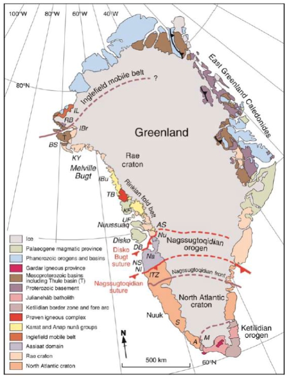
Sources: St. Onge et al. 2009
| SRK EXPLORATION LIMITED ■ JUNE 2026 | 49 |
| Technical Report Summary for the Disko-Nuussuaq Project |
| GEOLOGICAL SETTING AND MINERALISATION |
Figure 6-2: Simplified geological map of West Greenland and the Nuussuaq Basin.
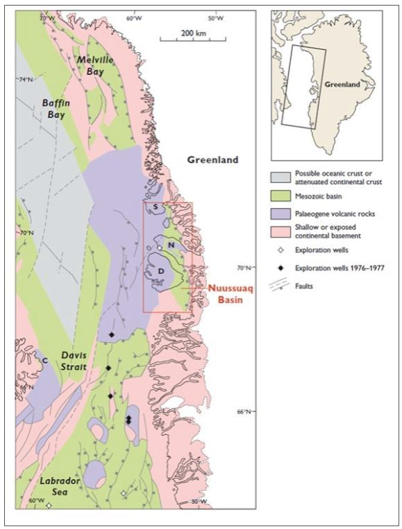
Sources: Larsen & Pedersen, 2009.
Notes: Based on Escher & Pulvertaft (1995), Chalmers & Pulvertaft (2001), Oakey (2005) and Gregersen et al. (2007). C, Cape Dyer, D, Disko, N, Nuussuaq, S Svartenhuk Halvø
| SRK EXPLORATION LIMITED ■ JUNE 2026 | 50 |
| Technical Report Summary for the Disko-Nuussuaq Project |
| GEOLOGICAL SETTING AND MINERALISATION |
| 6.2 | Local Geology |
The Disko-Nuussuaq district comprises Archean crystalline basement overlain by Cretaceous to Palaeocene sedimentary rocks of the Nuussuaq Basin and Palaeocene volcanic rocks of the West Greenland Igneous Province (Figure 6-3). The sediments are preserved within fault-bounded basins developed during Cretaceous extension, whilst the volcanic succession comprises thick sequences of picritic and basaltic lava flows emplaced during Palaeocene rifting and continental break-up (60.5 and 59.4 Ma). Major fault systems exerted a strong control on both basin development and magma emplacement (Chalmers 1999, Storey et al., 1998)
Disko Island is separated from Nuussuaq and the mainland by the Vaigat Sound in the east and the Disko Bugt sound to the south.
Figure 6-3: Local geology of the Disko-Nuussuaq area
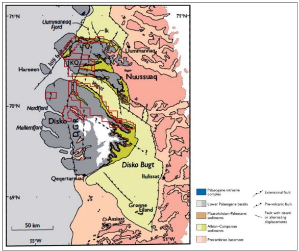
Sources: Modified from Dam & Pedersen. 2009
Notes: Licence areas held by Nikkeli indicated in red. Ik, Ikorfat Fault Zone; DGR, Disko Gneiss Ridge; KQ, Kuugannguaq– Quinnlik Fault
| SRK EXPLORATION LIMITED ■ JUNE 2026 | 51 |
| Technical Report Summary for the Disko-Nuussuaq Project |
| GEOLOGICAL SETTING AND MINERALISATION |
| 6.2.1 | Basement Geology |
The Precambrian basement underlying the Disko-Nuussuaq region is generally covered within the licence areas and only outcrops in a few places (Figure 6-3) . Although the basement itself is not considered a primary exploration target for magmatic Ni-Cu-Co-PGE mineralisation, its structural architecture exerted a first order control on the Nuussuaq basin, affecting localisation of major fault systems and subsequent ascent of Palaeogene magmas associated with the West Greenland Igneous Province. Therefore it is useful to understand or infer the basement composition and architecture from outcrop or mainland proxies.
The Precambrian basement underlying the Disko-Nuussuaq region forms part of the Rae Craton, one of the plates welded together to form the Laurentian shield. Locally, these rocks are Archean to Paleoproterozoic in age, and comprise gneisses, granitoids, metavolcanics and supracrustal successions that were subsequently reworked during the Paleoproterozoic Nagssugtoqidian Orogeny (Pulvertaft, 1999). It was extensively modified during the Cretaceous extension, resulting in the development of fault-oriented basins subsequently infilled by sedimentary rocks of the Nuussuaq Basin.
Lithologies on Disko Island where observed comprise tonalite-trondhjemite-granodiorite (“TTG”) gneisses together with metavolcanic and metasedimentary rocks of Archean affinity.
Although basement rocks underlie the entire project region, they can only be observed at surface east of the project area on the mainland, and locally on Disko Island along the Disko Gneiss Ridge in nearby valleys. This is because the basement was downthrown to the west by the action of the major basin-bounding fault systems, the Eastern Boundary Faults, with the exception of the ridge, which represents an area of localised uplift.
The basement east of the Nuussuaq Basin essentially displays the footwall to the rocks which have been downthrown under the project area. They comprise Archean greenstone belt assemblages including greenschist-facies mafic volcanics, metapillow lavas and associated gabbroic to doleritic intrusions (Pulvertaft, 1999; Marshall and Schonwandt,1999). The deformation in this area is stated as less intense than elsewhere in the Nagssugtoqidian Orogen and preserves many of the primary lithological relationships Garde and Steenfelt (1999).
The Disko Gneiss Ridge, (DGR on Figure 6-3), is a N-S trending elevated area controlled by the Kuugannguaq-Quinnlik fault system developed from rift-related block uplift occurring during the Eocene and later stages of basin evolution.
In the basement directly south of Disko Island lies a large East-West oriented suture zone of Precambrian origin, marked as the Disko Bugt Suture on Figure 6-1. This structure represents the boundary between rocks from the Rae craton from rocks of the Nunatarsuaq Group in the south. This suture zone was formed by tectonic accretion of Laurentia by the collision of the Rae Craton with the Aasiaat and North Atlantic cratons to the south during Nagssugtoqidian Orogeny (1.86 to 1.84 Ga; St-Onge et al., 1999; Escher & Pulvertaft, 1999), forming the Rinkian fold belt. Old, long-lived structures such as this have the potential to act as conduits for fluid migration, including acting as magma conduits. Although it is south of the project area, its structural orientation is useful since similar subordinate structures may exist directly under Disko-Nuussuaq.
| SRK EXPLORATION LIMITED ■ JUNE 2026 | 52 |
| Technical Report Summary for the Disko-Nuussuaq Project |
| GEOLOGICAL SETTING AND MINERALISATION |
| 6.2.2 | Cretaceous Nuussuaq Basin Sediments |
The Cretaceous to Palaeocene sediments of the Disko-Nuussuaq region belong to the Nuussuaq Group and unconformably overlie the Precambrian basement in a system of smaller, linked, fault-controlled basins collectively referred to as the Nuussuaq Basin.
The Nuussuaq Basin is the only exposed Cretaceous to Palaeocene sedimentary basin in West Greenland, and forms part of a larger system of linked rift basins extending from the Labrador Sea to Baffin Bay. As a result, the local area has been subjected to several stratigraphic studies for hydrocarbon exploration across recent several decades wherein onshore geology was used to formulate proxies for both local and offshore targeting.
The onset of basin development occurred during a period of Late Mesozoic extension associated with progressive opening of the Labrador Sea and was strongly controlled by major fault systems along the West Greenland margin (Chalmers et al.,1999; Dam et al., 2009).
Thick succession of non-marine to marginal marine sedimentary rocks deposited within fault-controlled depocentres which are collectively referred to as the Nuussuaq Group. It includes basal conglomerates and breccias deposited from the late Albian, overlain by fluvial to deltaic sandstones, mudstones, carbonaceous shales and coal-bearing intervals. The sedimentary thickness varies significantly across the basin, reflecting syn-depositional fault movement, basin relief and differential subsidence. The total thickness can vary as much as from 1 to 8 km with thickest sediments in the west and shallowest to the east reflecting the basin subsidence pattern. It is extensively preserved in the project area, and generally overlain beneath thick volcanic successions of Palaeocene or later age (Dam et al., 2009; Pedersen and Larsen, 2006).
Locally, these rocks are sub-divided into the Atane, Itilli, Kangilia, Eqalulik and Atanikerluk formations. They collectively record repeated changes in depositional environment from deep marine basins to deltaic and coastal plain settings. These sediments are locally intruded by igneous sills and dykes of younger age (Chalmers, 1999).
The carbonaceous shale, mudstone and coal-bearing intervals of the Nuussuaq Group are considered particularly significant to the magmatic Ni-Cu-Co-PGE exploration model owing to their sulphur content and plausibility as a source of crustal sulphur and carbon, both of which contribute to sulphide saturation during magma ascent and emplacement. Further, the presence of reducing, carbonaceous sedimentary rocks is also consistent with the development of native iron-bearing and sulphide-bearing volcanic and intrusive rocks documented elsewhere in the Disko-Nuussuaq district.
Although the Cretaceous Nuussuaq Group sediments are not the primary exploration target, the unit’s distribution, thickness and structural relationship with Palaeocene magmatic feeder systems are critical for understanding regional prospectivity. Areas where primitive mafic to ultramafic magmas interacted with sulphur-bearing sedimentary rocks, particularly along major faults and basin margins are considered favourable settings for the development of magmatic sulphide mineralisation.
The Cretaceous rocks are well studied east of the flood basalt terrain on eastern Disko from hydrocarbon exploration.
| SRK EXPLORATION LIMITED ■ JUNE 2026 | 53 |
| Technical Report Summary for the Disko-Nuussuaq Project |
| GEOLOGICAL SETTING AND MINERALISATION |
| 6.2.3 | Palaeocene Volcanic Rocks |
The Cretaceous sedimentary rocks of the Nuussuaq Basin are overlain by an extensive volcanic succession belonging to the West Greenland Igneous Province. Magmatism during the Palaeocene continental break-up created extensive deposits that are dominated by basaltic and picritic lava flows with subordinate volcaniclastic deposits, intrusions and locally contaminated volcanic units. These units trace an environmental change from submarine to terrestrial deposition as volcanism filled marine basins. Subsequently the rocks are co-eval with several sedimentary successions, which together form a relatively complex and highly localised distribution; in part owing to both local faulting and the evolution of multiple volcanic vents and fissures, illustrated by Figure 6-4.
Figure 6-4: DIsko Island geology and Palaeocene stratigraphy
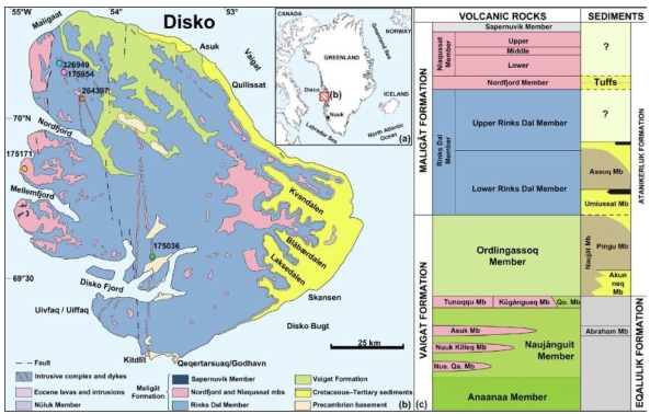
Sources: After Ulff-Møller, 1985, Ulff-Møller, 1990, Klöck et al., 1986, Pedersen et al., 2017, Pedersen et al., 2018
Notes:(a), simplified geological map (b), and stratigraphic subdivision of the Paleocene volcanic rocks and sediments (c) of Disko Island. Nus. Qa. Mb – Nuusap Qaqqarsua Member; Qo. Mb – Qordlortorssuaq Member.
Stratigraphic subdivision of the Paleocene volcanic rocks and sediments on Disko and Nuussuaq. The 'thicknesses' of the units in the diagram are intended to approximately reflect their volumes although this is not always possible. The ringed units do not extend throughout the succession, and the small ones are distinctly local. Crustally contaminated units are shaded red, and alkaline units in purple (red outline indicating contamination), geochemically enriched units have a dashed outline. Abbreviations (in stratigraphic order): Nus. Qa. Mb: Nuusap Qaqqarsua Member. He: Henderson unit. Ta: Tunorsuaq-a unit. Ni: Niiortuut unit. Tb: Tunorsuaq-b unit. Uk: Ukallit unit. St: Stordal alkaline unit. Qo. Mb: Qordlortorssuaq Member. cbs: contaminated basalts in Stordal. ap: alkali picrites associated with the Manitdlat Member. The lower and upper Rinks Dal Member are further subdivided into a number of chemostratigraphic units not shown. Sediment members from Dam et al. (2009): Marine mudstones are grey, non-marine mudstones are brownish-grey, sandstones are yellow and coal layers are black..
The principal volcanic units are the Vaigat Formation and the overlying Maligât Formation, with younger Svartenhuk and post-Maligât volcanic units occurring locally (Table 6-1).
| SRK EXPLORATION LIMITED ■ JUNE 2026 | 54 |
| Technical Report Summary for the Disko-Nuussuaq Project |
| GEOLOGICAL SETTING AND MINERALISATION |
| Table 6-1: Eruptive magmatic events in the Disko-Nuussuaq region. | |||
| Event | Age | Description | Volume |
| Vaigat | ~62.5 to 61 Ma | Large primitive, picrite High MgO Low Ni Evidence of crustal contamination Contains native iron on Disko Sulphide-bearing volcanic units | ~22,000 km3 |
| Maligât | ~61 to 60 Ma | Largest volume Tholeiitic flood basalts | ~68,000 km3 |
| Svartenhuk | ~60 to 58 Ma | Smaller | |
| Naqerloq Fmn | ~57 to 54 Ma | Late, very small volume | |
| Younger alkaline events | <54 Ma | Minor | |
Sources: Chalmers, 1999
Vaigat Formation
The earliest major phase of volcanism in the Disko-Nuussuaq region is represented by the Vaigat Formation and comprises picritic to basaltic lava flows, hyaloclasites, and associated feeder systems. The formation is characterised by primitive, high Mg-O magmas and includes several units that show evidence of interaction (“contamination”) with sedimentary rocks of the Nuussuaq Basin. Picritic magmas are those composed of picrite, a dark heavy silica-poor (ultramafic) igneous rock. Picritic rocks are generally rich in magnesium and iron and compose very fluid, high-temperature lavas with a low silica content .
The Vaigat is separated into three main episodes which are again divided into several members and units Figure 6-4.
| 1. | The Anaanaa Member (oldest) |
| 2. | The Naujánguit Member |
| 3. | The Ordlingassoq Member (youngest) |
Its total thickness varies up to 1,600m and is thickest on the western Nuussuaq peninsula. During the second and third episodes, volcanism spread eastwards and southwards forming a domed shield-like structure spreading from west Nuussuaq, south over Disko Island and east over the Precambrian basement towards the mainland. Different units vary in volume, extent and so the lateral distribution is highly variable across the project area.
Volcanism originated in a seawater environment and so earlier successions are intercalated with marine sediments. Successive lavas also trace a change in polarity of the geomagnetic field (Pedersen & Larsen, 2017). Each member records a magmatic cycle starting with primitive picritic magmas and ending with more evolved, usually contaminated magmas (Harald and Pedersen, 1975; Pedersen et al., 1996; Larsen and Pedersen, 2009).
| SRK EXPLORATION LIMITED ■ JUNE 2026 | 55 |
| Technical Report Summary for the Disko-Nuussuaq Project |
| GEOLOGICAL SETTING AND MINERALISATION |
The contaminated marker beds observed in the Vaigat demonstrate that their Mg-rich magma has reacted with sediments during magma migration and ascent through the deeper, underlying Cretaceous sediments and basement.
While less significant in volume, the older Vaigat Formation is considered more prospective for magmatic Ni-Cu-Co-PGE mineralisation due to its primitive magma chemistry and stronger evidence for crustal contamination.
Contamination occurs through reaction whereby metals and other elements can be stripped from the host rock and adopted into the magma. These units can be differentiated based on MgO and SiO2 percentages (Pedersen & Larsen, 2007) as well as from elemental depletion. These contaminated members are noted to have individually distinct compositions, indicating changing conditions of contamination. Oil seeps are noted from mapping and drilling.
Magma chambers are believed to have developed within the Cretaceous Nuussuaq Group, and fractionated sulphides bearing Cu and Ni have been detected in some of the contaminated magmas in the Asuk and Kuugannguaq subordinate members.
Crustally contaminated lava flows, tuffs, dykes, volcanic necks and craters are widespread on Disko and Nuussuaq (Gulbrandsen, 2014). These contaminated Vaigat volcanic rocks locally contain native iron, graphite-bearing assemblages, sedimentary xenoliths and sulphide-bearing material indicating interaction between ascending magma and carbonaceous sedimentary rocks Figure 6-5.
Vaigat Contaminated Sequences have been reasonably well studied and are well described in
Amec’s Technical Report on the Disko Nuussuaq Project for Avannaa from 2015.
The contaminated units include three small, local units that occur in northern Nuussuaq (Tunorssuaq a and b) and Disko (Stordal alkaline centre) (Larsen and Pedersen, 2009); and five large, extensive members Table 6-2.
Table 6-2: Contaminated units summary
| Contaminated unite | Stratigraphic Position |
Characteristics | Significance | |||
| Asuk Member | Vaigat Fmn | Strongly contaminated picrites and basalts with graphite xenoliths, native iron, and cohenite | Classic example of magma reduction by sediment assimilation, evidence for interaction with carbonaceous sediments | |||
| Skarvefjeld Unit | Vaigat Fmn | Contaminated basaltic lavas containing sediment-derives xenoliths and sulphide-bearing lithologies | Demonstrates widespread crustal contamination during eruption | |||
| Nunngarut Unit | Vaigat Fmn | Iron-bearing contaminated volcanic rocks with abundant sedimentary inclusions | Records extensive reduction and native iron formation | |||
| Ilugissoq / Igdlukunguaq Units | Vaigat Fmn | Contaminated picrites containing graphite-rich xenoliths and reduced mineral assemblages | Key locality for understanding magma contamination processes | |||
| Kuugannguaq Units | Vaigat Fmn | Contaminated lava flows associated with intrusive rocks and sediment assimilation | Demonstrates interaction between volcanic plumbing systems and basin sediments along major structural corridors. |
Sources: Adapted from Larsen & Pedersen 2009
| SRK EXPLORATION LIMITED ■ JUNE 2026 | 56 |
| Technical Report Summary for the Disko-Nuussuaq Project |
| GEOLOGICAL SETTING AND MINERALISATION |
Figure 6-5: Contaminated Vaigat Asuk Member
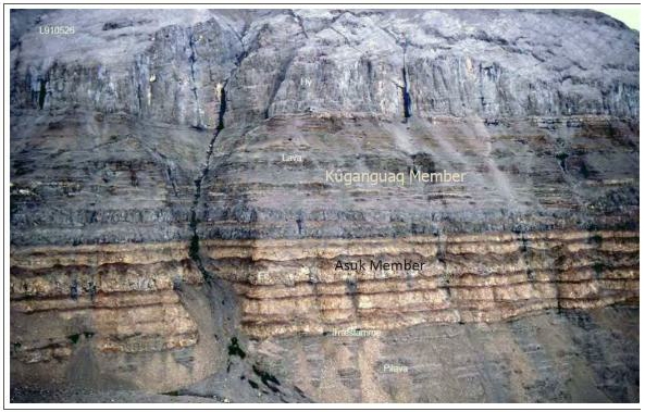
Sources: Pedersen & Larsen, 2018
The eruption sites for several of these contaminated units are illustrated in Figure 6-6 below.
| SRK EXPLORATION LIMITED ■ JUNE 2026 | 57 |
| Technical Report Summary for the Disko-Nuussuaq Project |
| GEOLOGICAL SETTING AND MINERALISATION |
Figure 6-6: Eruption sites for contaminated units
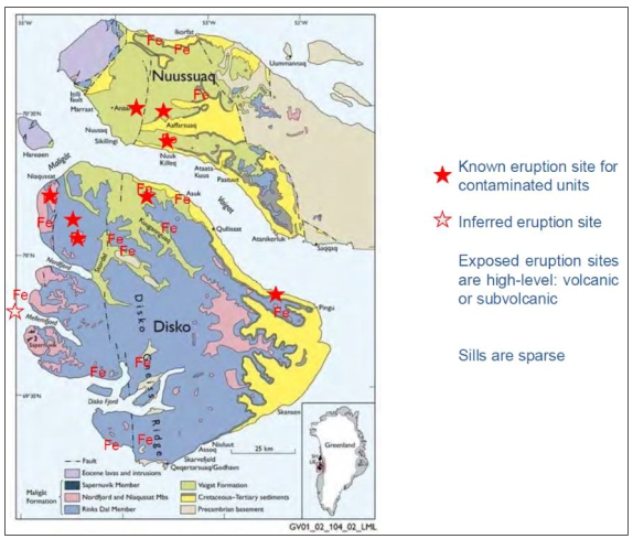
Sources: 80 MIle, 2025
Maligât Formation
The Maligât Formation represents the main volumetric phase of tholeiitic flood basalt volcanism in the region and conformably overlies the picritic and basaltic rocks of the Vaigat. The formation is widely exposed across Disko Island and Nuussuaq, forming extensive plateaus and prominent cliff-forming escarpments.
The rocks are more evolved than the Vaigat Formation, representing a transition from picritic magmatism of the Vaigat Formation to more evolved tholeiitic basaltic volcanism, reflecting the continued development of the North Atlantic Igneous Province.
Rocks comprise laterally extensive subaerial basaltic lava flows, and associated subordinate volcaniclastic and sedimentary interbeds. Individual lavas can me several tens of metres thick, while the succession can exceed over 2km in thickness from repeated fissure-fed volcanic events across the region.
Maligât Formation rocks are described as olivine-poor tholeiitic basalts, and less magnesian, contrasting strongly with the Vaigat. It is divided into multiple component members, and fewer occurrences of crustal contamination are noted. It represents widespread flood basalt volcanism that buried earlier volcanic centres, basins and topographic relief that developed during the Vaigat.
| SRK EXPLORATION LIMITED ■ JUNE 2026 | 58 |
| Technical Report Summary for the Disko-Nuussuaq Project |
| GEOLOGICAL SETTING AND MINERALISATION |
Svartenhuk Formation and decline of Volcanism
Volcanic activity continued to a lesser extent through the late Palaeocene and into the Eocene, however these lavas are not well preserved in the project area.
These include the Svartenhuk Formation, Naqerloq and later alkaline volcanic events which occurred across the broader West Greenland volcanic arc succession.
These unit post-date the two earlier phases and are generally more limited in extent within the project area. They represent continue magmatic activity and are compositionally distinct from their predecessor the Vaigat and Maligât, representing small-volume, mantle-derived magmas. On Nuussuaq the Eocene Naqerloq Formation is present, the west of the Itilli fault. Sills are also observed in south Nuussuaq and on western Disko associated with Eocene lavas. These dykes and sills can be determined as Eocene age since they are compositionally different from older Palaeocene volcanics (Pedersen, 2018).
Intrusive Rocks
Intrusive rocks associated with the volcanic succession include dykes, sills and possible feeder conduits emplaced into both the sedimentary succession and earlier volcanic rocks. These intrusions are important as they represent potential magma transport pathways between deeper magmatic sources and the preserved volcanic pile. Ascending magma adopts the pathway of least resistance, and this is frequently brecciated or weak zones of faulting, so these conduit systems are commonly associated with major fault systems and basin margins.
Chalmers (1999), and Pedersen and Larsen (2006), both describe how fault re-activation channelled magma from deep sources into shallow chambers and then to eruption sites, forming the substantial thicknesses of basalts that overlie the sediments.
Sills are common in the Cretaceous and its noted they may be laterally very continuous. Contact metamorphism if widespread with hydrothermal alteration as hot magma were emplaced into organic-rich mudstones, sandstones and coal-bearing strata. Larger intrusions are noted in doleritic to gabbroic composition and can exhibit evidence of crustal contamination. The assimilation of carbonaceous and sulphur-bearing sediments has been documented in several intrusive complexes and is reflected by the occurrence of graphite-bearing xenoliths, sulphide mineralisation and more locally, native iron-bearing lithologies.
Intrusions within fault planes are also documented in the Sarqaq area as undeformed dolerites dated at approximately 54.7 Ma (Storey et al. 1998), inferring that movement here ceased by 55 Ma.
| 6.2.4 | Structural Geology |
The local structural architecture of the Disko-Nuussuaq region reflects multiple phases of extension, volcanism, and subsequent tectonic inversion associated with the development of the West Greenland continental margin.
| SRK EXPLORATION LIMITED ■ JUNE 2026 | 59 |
| Technical Report Summary for the Disko-Nuussuaq Project |
| GEOLOGICAL SETTING AND MINERALISATION |
Dominant structures include basin-bounding normal listric faults, transfer faults and deep-seated crustal lineaments that controlled sediment deposition within the Nuussuaq Basin and later influenced emplacement of Palaeocene magmas associated with the West Greenland Igneous Province. Subsequent episodic inversion reactivated parts of this structural framework.
Cretaceous Rift Architecture
Development of the Nuussuaq Basin was controlled by regional extensional tectonics during the Late Cretaceous. These faults accommodated significant crustal extension during the Cretaceous and form an oblique and complex margin of linked rifted basins.
Two episodes of regional rifting and basin development have been established in the region by Dam and Sønderholm 1998, Dam et al. 2000; Chalmers & Pulvertaft, 2001 Dam, 2002; and Sørensen 2006) during the early Cretaceous and late Cretaceous to early Palaeocene.
| SRK EXPLORATION LIMITED ■ JUNE 2026 | 60 |
| Technical Report Summary for the Disko-Nuussuaq Project |
| GEOLOGICAL SETTING AND MINERALISATION |
Figure 6-7: Geological and structural overview of Disko Island and the Nuussuaq Peninsula
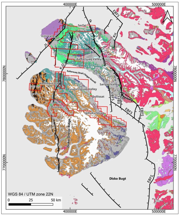
Sources: GEUS Geology; SRK EX, 2026
Notes: EBFS: Eastern Boundary Fault System; K-Q : Kuugannguaq – Quinnlik fault; It: Itilli fault; A : Agatdalen fault; Ik: Ikorfat; Ku: Kuuk fault. Refer to Figure 6 6 for legend.
| SRK EXPLORATION LIMITED ■ JUNE 2026 | 61 |
| Technical Report Summary for the Disko-Nuussuaq Project |
| GEOLOGICAL SETTING AND MINERALISATION |
Figure 6-8: Project stratigraphy and map legend
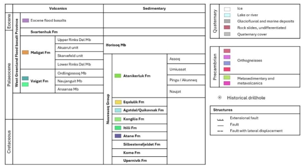
Sources: SRK EX. 2026
Notes: Legend denoting geological, structural and historical boreholes – simplified for brevity. Refer to Figure 6 5, Figure 6 7, Figure 6 11.
There are three main fault systems transecting the project area from east to west, the Eastern Boundary Faults (EBFS or Kuuk–Sarqaq–Qeqertaq), the Kuugannguaq–Quinnlik (KQ) fault, and the Itilli fault (IT)(Figure 6-7).
These faults generally dip westward between 47 and 73° and include listric faults with as much as 2 km westward offset. Many faults are detectable from both surface geology and seismic basin studies. (Rosenkrantz & Pulvertaft, 1969; Pulvertaft, 1979, 1989). It is considered that fault progression started in the east and progressed westwards however this required further study.
Itilli Fault
Within the project area, the Itilli Fault intersects the western end of the Nuussuaq Peninsula. It is a steeply dipping normal fault and downthrows sediments to the northwest. The fault is a principal basin-bounding fault and potential extension to the Ungava Transform Fault system which separates Greenland from Baffin Island (Larsen and Pedersen, 1992). Movement on the fault has not been directly dated but is constrained by stratigraphy as originating during the Late Cretaceous and continuing to be active throughout Palaeocene magmatism (Chalmers, 1999). It was also locally reactivated during the Eocene-Oligocene basin inversion, (Dam, 2007).
Kuugannguaq-Quinnlik Fault
Initiating in the vicinity of the Itilli Fault in northern Nuussuaq, The K-Q Fault runs NNE-SSW via a series of interlinked faults from Nuussuaq peninsula, through the Vaigat Sound and across the full extent of Disko Island. It is less well studied than the Itilli but is regarded as a long-lived, basin-scale fault active during the Late Cretaceous and throughout the Palaeocene. It is considered to be a steep basement-related structure which played an important role as a magma conduit (Dam, 1997, 2009; Chalmers, 1999).
| SRK EXPLORATION LIMITED ■ JUNE 2026 | 62 |
| Technical Report Summary for the Disko-Nuussuaq Project |
| GEOLOGICAL SETTING AND MINERALISATION |
Eastern Boundary Faults / Kuuk-Sarqaq-Qeqertaq
The eastern boundary faults delineate the eastern basin margin contact with Precambrian basement to the east. The are a series of stepped and linked normal and transform faults with a complex ramp structure in the north in the vicinity of the Ikorfat fault zone. It is a system of NNW-SSE trending normal faults and associated W-E to WNW-ENE trending transfer faults.
These fault zones are discussed in more detail in section 6.3. These three structures and associated sub-ordinate faults collectively controlled basin development, magma emplacement and preservation of the volcanic succession. Their orientation and development would have been influenced by pre-existing weaknesses and faults in the Precambrian basement, however, little is known of these since there is very little basement outcrop in the local area.
Since the Precambrian structures will be deeper, it will be important to determine which may have been activated or re-activated during the magmatic events to assess the potential to act as magma conduits.
Structural controls on volcanism
Palaeocene magmatism within the Disko-Nuussuaq region was strongly influenced by the pre-existing structural framework established during Late Cretaceous rifting acting as pathways permitting magma to ascend. Major basin-bounding faults and inherited basement structures remained active or were reactivated during volcanic emplacement, providing pathways for magma ascent and exerting significant controls on the distribution of volcanic centres, intrusive complexes and volcaniclastic deposits.
Field relationships throughout the project region indicate that volcanic and intrusive activity was commonly localised along pre-existing fault zones. Reactivation of these structures during volcanism likely enhanced crustal permeability, facilitating magma transport through both the sedimentary succession and the developing volcanic pile.
It has been observed that numerous volcanic centres, dyke swarms and intrusive bodies occur with and display spatial relationships with N-S and NNE-SSW trending fault systems that parallel the dominant structural grain of the basin established during the Cretaceous. The nature of listric faults lend themselves to act as magma conduits, since they are generally large, deep zones of brittle deformation and fracture extending deep both vertically and laterally often running several kilometres into the crust. These zones exhibit enhanced crustal permeability that facilitated repeated magma ascent from deep, and through the sedimentary succession and the overlying volcanic pile.
The Kuugannguaq-Quinnlik (“K–Q”) fault zone has been studied for its relationship to magmatism since it is a long-lived structure interpreted to have originated during Cretaceous extension and subsequently experienced multiple phases of reactivation. This fault zone forms an important structural boundary within the Nuussuaq Basin and is associated with variations in stratigraphic thickness, volcanic facies distribution, and intrusive activity (Chalmers, 1999). Its persistence through successive tectonic and magmatic events suggest that it acted as a significant conduit for magma transport during development of the West Greenland Volcanic province.
| SRK EXPLORATION LIMITED ■ JUNE 2026 | 63 |
| Technical Report Summary for the Disko-Nuussuaq Project |
| GEOLOGICAL SETTING AND MINERALISATION |
The orientation of these deep Cretaceous listric faults will have been influenced by pre-existing weaknesses and faults in the Precambrian basement, however little is known of these since there is very little outcrop in the local area. Since the Precambrian structures will be deeper, it will be important to determine which may have been reactivated and utilised by magma during the Cretaceous to assess the potential to act as magma conduits. Structural intersections between the Precambrian basement and Cretaceous faults would present significant pathways for magmatic flow and mineralisation potential.
Oligocene fault reactivation
During the Eocene to Oligocene the region experienced a period of tectonic compression and volcanic acquiescence associated with the development of the North Atlantic margin. Regional compression is dated between 50-35Ma. This resulted in local reactivation of earlier extensional faults, causing basin inversion, folding and uplift of the Cretaceous sedimentary package and overlying volcanics. This is expressed as broad open folding, and steep reverse faulting as well as thickening of the volcanic pile.
Post-Oligocene (<34Ma), tectonic stresses on the regional have been largely dormant, with minor uplift, erosion and glaciation related rebound.
| 6.3 | Property Geology |
| 6.3.1 | Nuussuaq Peninsula |
80 Mile holds three adjacent exploration licences over the western area of the Nuussuaq Peninsula: MEL 2019-116 (north), MEL 2018-116 (north), and MEL 2012-29 which lies within MEL 2018-116 Figure 5-16. These three licence areas cover north Nuussuaq and the Itilli fault down to the coast at Marraat, and along the Aaffarsuaq Valley.
| SRK EXPLORATION LIMITED ■ JUNE 2026 | 64 |
| Technical Report Summary for the Disko-Nuussuaq Project |
| GEOLOGICAL SETTING AND MINERALISATION |
Figure 6-9: Licences across Nuussuaq
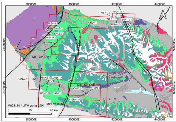
Sources: SRK EX, 2026; GEUS geology
Notes: EBFS: Eastern Boundary Fault System; K-Q : Kuugannguaq – Quinnlik fault; It: Itilli fault; A : Agatdalen fault; Ik: Ikorfat; Ku: Kuuk fault. Refer to Figure 6-8 for legend.
The majority of the project area on Nuussuaq is predominantly underlain by rocks of the Vaigat Formation separated from younger Eocene volcanic rocks to the west by the Itilli fault. The licence area occupies part of the central volcanic basin where thick successions of picritic and basaltic lava flows overlie fault-controlled Cretaceous sedimentary rocks of the Nuussuaq Basin. The Cretaceous rocks within the licence area comprise fluvio-deltaic sediments of the Atane Formation, and are largely obscured and overlain by Palaeocene volcanism with the exception of the valley bluffs in the Aaffarsuaq valley.
The Vaigat formation here comprises basaltic to picritic lithologies, including units displaying crustal contamination preserving evidence of magma-sediment interaction such as graphite-bearing xenoliths, sediment-derived sulphides, contaminated rocks, and native-iron bearing lithologies. The region of western Nuussuaq is important as a site of multiple eruptive centres over time, Figure 6-10 highlighting its importance as a region of magma localisation and repeated pathway development.
| SRK EXPLORATION LIMITED ■ JUNE 2026 | 65 |
| Technical Report Summary for the Disko-Nuussuaq Project |
| GEOLOGICAL SETTING AND MINERALISATION |
Figure 6-10: Geological map of Nuussuaq and northern Disko showing extent of erupted Ananna and Nuuk Killeq Members
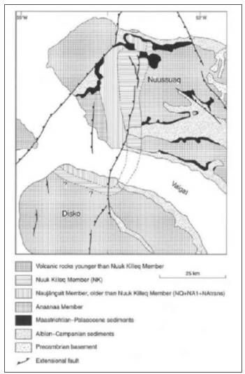
Sources: Pedersen et al 2002
There are three main fault zones traversing the Nuussuaq peninsula: from east to west: the Ikorfat, the K–Q fault, and the NE-SW trending Itilli fault. Each of these faults is a Cretaceous extension rift fault of which the Itilli Fault shows the most significant displacement.
The Itilli Fault trends SW–NE and dates to the Cretaceous and/or Eocene. It is a large-scale listric fault with <2 km downthrow to the west and represents an extension of the Ungava Transform Fault which spreads north into Baffin Bay (Guan et al. 2023; Chalmers et al. 1995, 1999; Dam and Sonderholm 1994; Larsen et al 2016; Storey et al. 1998). At surface, it separates younger basalts of Eocene age to the west, from older Paleocene volcanic rocks to the east.
Studies by Geoffroy et al. in 2005 and 2015, and Guan in 2023 on the evolution of the Nuussuaq margin identified describe the Itilli Fault from seismic data as an offshore, continent-facing detachment fault forming the northwest boundary to the west Nuussuaq basin. They describe the evolution of a link rift basin with detachment faults progressing in a seaward direction which can be dated by their delineation of Palaeocene to Eocene Vaigat, Maligât, and Kanisut basaltic formations and depicted in Figure 6-11. The basins developed with a large degree of obliquity to the spreading axis of the Labrador Sea, implying significant sinistral strike slip component of action on the Itilli Fault zone in addition to dip-slip. This will have created a much larger zone of crushing and destruction evidenced by the wide Itilli valley.
| SRK EXPLORATION LIMITED ■ JUNE 2026 | 66 |
| Technical Report Summary for the Disko-Nuussuaq Project |
| GEOLOGICAL SETTING AND MINERALISATION |
Figure 6-11: Evolution of the Itilli Fault Zone and west Nuussuaq basin.
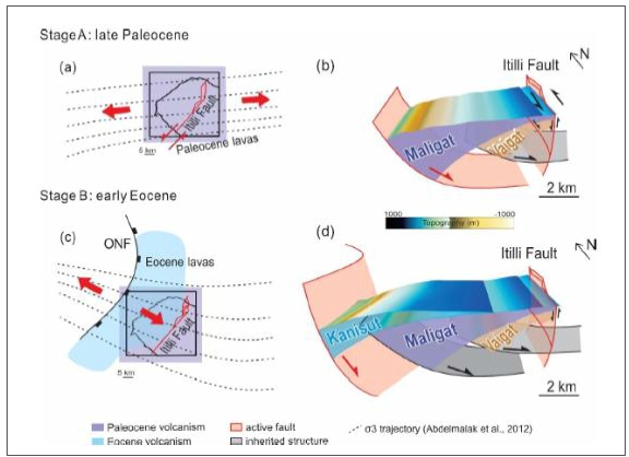
Sources: Guan et al., 2023
It has important implications for targeting magmatic nickel systems because it could have acted as a major conduit for ascending magmas, and its throw implies significant longevity.
West of the Itilli Fault, younger basalts of the Eocene age Kanisut Formation, are exposed at surface and only small windows of the older, Maligât and Vaigat Formations exposed at the very north and southern fault-proximal extents.
Aaffarsuaq
Aaffarsuaq is an east-west trending valley in south Nuussuaq with a broad, glacial valley floor, bound by steep northern and southern valley sides and bluffs. The geology of the area is largely consistent with Disko Island, whereby Cretaceous sedimentary successions form the low relief, and underlie Quaternary valley-fill sediments. These are capped by the Palaeocene Maligât and Vaigat volcanic groups forming the steeper bluffs; several Cretaceous-Paleocene age, N-S trending faults traverse the valley.
| SRK EXPLORATION LIMITED ■ JUNE 2026 | 67 |
| Technical Report Summary for the Disko-Nuussuaq Project |
| GEOLOGICAL SETTING AND MINERALISATION |
Aaffarsuaq is located over the northern extents of the erupted Asuk member – an igneous volcanic formation of lavas and dykes up to 150m thick and totalling over 1,000 km3 of material. The eruption site for the Asuk Member is believed to be the Illugissoq Volcano.
A suite of holes were drilled by grønArctic in the mid-1990s west of Aaffarsuaq near Marratt, targeting hydrocarbons and contribute to the stratigraphic knowledge of the western extent of the valley. Such stratigraphic studies highlight Cretaceous sediments of the Atane Member uncomfortably overlain by various thick Palaeocene lavas, hyaloclastites and breccias, generally flowing in an eastward direction (Figure 6-12). These are then overlain by eruptive lavas of the Ilugissoq volcano which are further overrun and capped by the tholeiitic flood basalts of the Ordlingassoq Member. Numerous feeder dykes and contaminated units are observed illustrating the existence of local magmatic plumbing systems.
Basement modelling by Chalmers in 1999 identified the possibility of a large intrusion at depth in the west Aaffarsuaq valley bound between the K-Q fault and another N-S trending fault to the east. A suite of geophysical studies over the valley identified coincident magnetic and gravity anomalies. Soil geochemistry also returned anomalous areas for Ni, Cu, Co and PGE pathfinder elements. Much later in 2007, Vismand Exploration attempted to drill two holes further east, targeting metals mineralisation. The holes (V-GRN-1, and V-GRN-1A) failed in overburden due to poor ground conditions. These anomalies are being drill tested in 2026 field campaign.
Figure 6-12: Cross-section through Nuussuaq and Aaffarsuaq valley.
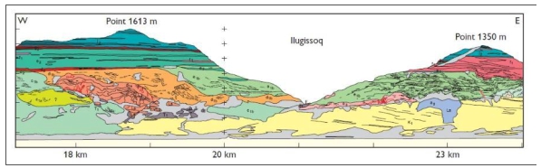
Sources: Pedersen, 2006
Notes: Cross-section through the Aaffarsuaq Valley looking north depicting the Illugissoq valley fault – a structure sub-parallel to the K-Q fault. Cretaceous sediments of the Atane Formation (Yellow) and the Palaeocene Equalik Formation (green). The progradation of volcanic rocks as subaqueous hyaloclasites breccias, and subaerial lava flows from the west to east is evidenced in the Palaeocene Nuuk Killeq Member (oranges), and the overlying Naujánguit Member (light green/turquoise). Foresets in volcanic units generally dip to the east, but irregular bedding structures are observed near eruption sites (pale green, right). Feeder dykes are outlined in red. The capping red rocks are pyroclastic rocks of the Ilugissoq volcano (Asuk Member) and are overrun by lavas of the Ordlingassoq Member (blue).
| 6.3.2 | Disko Island |
80 Mile hold seven exploration licences on Disko Island, three of which have second regions on Nuussuaq peninsula: MEL 2019-116, MEL 2012-29, MEL 2020-10, MEL 2018-16, MEL 2017-01, MEL 2024-30.
The region of the Nuussuaq Basin exposed onshore at Disko Island comprises much of the same stratigraphic successions found on the Nuussuaq peninsula except for specific local variations in Palaeocene lavas and hyaloclasites, and outcropping Precambrian basement near the Disko Gneiss ridge Figure 6-13. The geology of the main target areas at Qullissat, Kuugannguaq, Igdlujunguaq Stordal and Hammers Dal is described in this section.
| SRK EXPLORATION LIMITED ■ JUNE 2026 | 68 |
| Technical Report Summary for the Disko-Nuussuaq Project |
| GEOLOGICAL SETTING AND MINERALISATION |
Figure 6-13: Local geology of the Disko Island licence areas
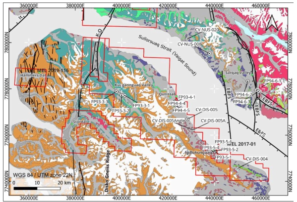
Sources: SRK EX. 2026; GEUS geology
Notes: Refer to Figure 6-8 for legend.
Qullissat
The geology at the Qullissat area is principally consistent with general geology of the Disko region. At the coast coal measures and sandstones of the Cretaceous sedimentary successions are well mapped and exposed at the coast, including the historical coal quarries. Upslope and inland these sediments are overlain by the Vaigat and Maligât Formations and the contact between the groups is exposed in the upper cliff face, marking the change from subaqueous to subaerial extrusives (LINK TO IMAGE). Much of the geology is obscured by landslides at surface Figure 6-14.
Further geophysical surveys identified several anomalies: a 600 x 900 m electromagnetic conductor at shallow depth interpreted to be the dyke, and an ~8km long NNW-trending AGG anomaly likely to be a mafic intrusion at depth.
The smaller conductor was targeted drilled by Falconbridge in FP94-4-5 and FP94-4-6 and broadly correlates with an intrusive unit, the Nunngarut Intrusion (labelled “Fe” in the image). The hole reached elevated Ni-Cu grades, native iron, and some gold; and the intrusion is stated as having reached sulphur saturation which would be an indicator for nickel concentrating conduit system in the locality.
| SRK EXPLORATION LIMITED ■ JUNE 2026 | 69 |
| Technical Report Summary for the Disko-Nuussuaq Project |
| GEOLOGICAL SETTING AND MINERALISATION |
Originally interpreted as an andesitic sill. In 2024 the Falconbridge cores were studied by Larsen & Pedersen who examined the stratigraphy including the targeted sill and interpreted it as an extrusive lava of the Asuk Member of the Vaigat Formation. Their stratigraphic correlation infers evidence of local faulting with a vertical offset of ~90m locally, and also further faulting south of Qullissaaqqat. The interpretation is based on a single drillhole, limited modelling and correlations of drone magnetic data that are spatially separate.
Evidence from geophysical data, and the fabric of the rock lend more evidence to an interpretation as an intrusive sill. Drilling planned for the 2026 field season will be targeting the Nunngarut Intrusion and anomaly.
Figure 6-14: Aerial image of the Qullissat area and Falconbridge drilling
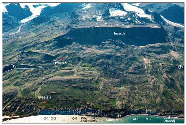
Sources: Photo: Kristian Svennevig, 2019. Interpretation by Larsen & Pedersen 2024
Notes: Oblique aerial photograph of the coastal area of Disko between the closed coal mines and Qullissaaqqat (immediately left of the picture). Falconbridge boreholes are indicated FP94-4-5 and FP94-4-6. (Fe) Extent of outcropping Nunngarut igneous body outcrop. The scale of the view is inferred by the coastal cliff heigh (~50m) and the plateau top of the Inussuk mountain (900 m).
| SRK EXPLORATION LIMITED ■ JUNE 2026 | 70 |
| Technical Report Summary for the Disko-Nuussuaq Project |
| GEOLOGICAL SETTING AND MINERALISATION |
Figure 6-15: Photogrammetry section of Qullissat
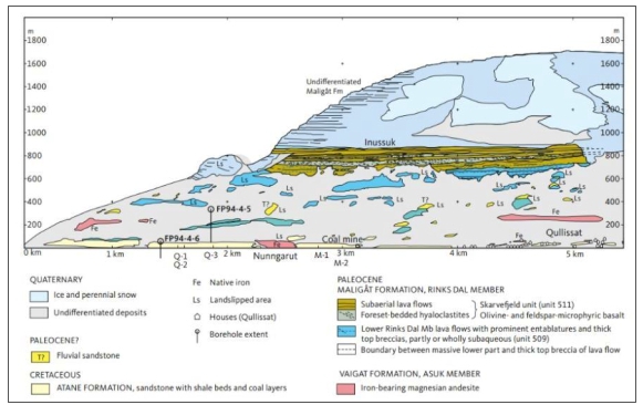
Sources: Larsen and Pedersen, 2024; modifeid from Pedersen et al. (2018, 2017)
Notes: Photogrammetrically measured and interpreted section of the coast of Disko between Qullissat (at right) and Qullissaaqqat (immediately left of section). Exposure of iron-bearing Nunngarut igneous body are red. Borehole vertical extents are indicated but note that perspectives are different because the section possesses no single point of view.
Igdlukunguaq
Situated on the northeast coast of Disko Island, Igdlukunguaq is the site of the discovery of a 28t massive sulphide boulder by Pauly in 1950. The mineralisation in the boulder was stated to contain 6.9% Ni, 3.7 % Cu, 0.6% Co and 2 g/t PGE and is the primary evidence for the existence of a Ni massive sulphide system at Disko-Nuussuaq. The exact relationship of the mineralised boulder to local geological setting remains to be determined since it was not found in in situ as outcrop but sitting separately at surface alongside a dyke.
As a result, the area has been well studied and contains some of the best exposures of sediment-contaminated Vaigat magmatism on northern Disko. Picritic lavas found here display abundant sedimentary xenoliths, and there is evidence of graphite-bearing volcanic rocks (produced by the assimilation of carbon from sediments), native-iron assemblages. These exposures demonstrate evidence of sediment interaction occurring within the basin stratigraphy prior to eruption and provide important evidence for processes responsible for modifying primitive mantle derived magmas, important to nickel mineralisation models.
| SRK EXPLORATION LIMITED ■ JUNE 2026 | 71 |
| Technical Report Summary for the Disko-Nuussuaq Project |
| GEOLOGICAL SETTING AND MINERALISATION |
Kuugannguaq
The Kuugannguaq Valley lies in the northern extent of Disko Island and exposes a geological section across the Disko Gneiss ridge and overlying sedimentary succession. Precambrian gneiss was intersected in borehole FP93-3-1 beneath sedimentary rocks of the Cretaceous Atane formation. The basement ridge extends northwards at least as far as the coast, where it is onlapped and buried by the Paleocene volcanic succession.
The valley contains much exposure of Vaigat Formation picrites and contaminated volcanic rocks including graphite and native iron-bearing flows of the Asuk Member. This is overlain by further basalt flows of the lower Rinks Dal (Maligât Formation). Stratigraphic analysis by Dam & Pedersen in 2009 estimated a thickness of 240m for the Maligât Formation here, where it onlaps south-east sloping Vaigat Formation rocks. The volcanic rocks record emplacement into a subsiding, intermittently marine basin from brecciated, ponded, and subaerial lava morphologies reveal brecciated, subaqueous.
The valley is adjacent to the K-Q fault system, a long-lived structure along which multiple phases of volcanism are related. It is interpreted to be a deep seated structure, having uplifted Precambrian basement along its margin, and therefore acted as a deep pathway enabling magmatic travel (Chalmers, 1999).
Stordal
The Stordal area lies south of the Kuugannguaq Valley and similarly traces similar geology along the K-Q fault and Disko Gneiss ridge. The valley occupies a structurally controlled depression adjacent to the K-Q fault.
There is little Cretaceous exposure in this region however numerous exposures of Vaigat Formation contain xenoliths of carbonaceous mudstone, sandstone, and coals. This indicates interaction between ascending magmas and organic-rich sedimentary successions such as the Atane and Itilli formations. The volcanic succession is dominated by Vaigat Formation picrites overlain by tholeiitic basalts of the Maligât Formation. Several lava units showing localised ponding adjacent to the basin edge and textures consistent with water interaction, similar to the setting of Kuugannguaq Valley.
Hammers Dal
The Hammer’s Dal target is in northwest Disko and contains well exposed sequences Palaeocene Vaigat and Maligât Formation rocks. It is part of the broader Nuussuaq basin that actively subsided to the west under the influence of rifting activity on the K-Q fault. This is reflected in the volcanic lavas which generally flowed westward in this area. Multiple smaller normal faults are also traced in northwest Disko, similar to the K-Q fault. The area is situated within the same Palaeocene flood basalt terrain as the rest of Disko, and multiple contaminated sequences can also be traced here.
| 6.4 | Mineralisation |
Mineralisation in the Disko-Nuussuaq region is closely associated with the Palaeocene magmatism of the West Greenland Flood Basalts and involves the interaction of mantle-derived magmas with sulphur- and carbon-rich Cretaceous sedimentary rocks.
| SRK EXPLORATION LIMITED ■ JUNE 2026 | 72 |
| Technical Report Summary for the Disko-Nuussuaq Project |
| GEOLOGICAL SETTING AND MINERALISATION |
Mineral occurrences to date support this and include native iron-bearing rocks, magmatic Ni-Cu-Co-PGE sulphide mineralisation found in both float and indicated through soil geochemical anomalies.
| 6.4.1 | Native Iron |
Native iron occurs in the Kuugannguaq and Quinnlik areas. It is most commonly associated with contaminated picrites and basalts of the Vaigat Formation and occurs with cohenite, troilite, and graphite. These assemblages indicate extreme reduction of mantle-derived magmas during assimilation of carbonaceous sedimentary rocks. The presence of assimilated carbon material with iron combined with high heat flow of the magma has created a blast furnace effect creating native iron.
| 6.4.2 | Magmatic Ni-Cu-Co-PGE |
Across the Disko-Nuussuaq project area there are multiple documented occurrences of anomalous Ni-Cu-Co-PGE mineralisation, as well as repeated evidence of geological features indicative of a magmatic sulphide system. Magmatic sulphide mineralisation is observed associated with contaminated mafic and ultramafic intrusives and related volcanic rocks. The sulphides observed in the project area include pyrrhotite, pentlandite, and chalcopyrite with associated cobalt and platinum group elements. These occurrences have been found at Marraat, Stordal, Kuugannguaq, Asuk, Hammer Dal, Qullissat, Aaffarsuaq and Interlak areas. The most prospective exploration targets at Disko-Nuussuaq are thought to be subvolcanic conduits, chonoliths and feeder intrusions associated with early Vaigat picritic magmatism, since it represents the most primitive and potentially most metal-rich phase of magmatism. (Larsen, 2009, and 2022)
Although to date, no economic mineralisation has yet been found in the project region, these areas provide repeated evidence of elements of a magmatic conduit system; features which are analogous to major magmatic sulphide camps such as at Norilsk, Voisey’s Bay.
Mineralisation observed to date within the project region is summarised below:
| § | Historic Igdlukunguaq massive sulphide boulder |
| – | In the 1860s, a 28 ton boulder of pure massive magmatic sulphide was discovered next to the Igdlukunguaq Dyke on northeast Disko Island. Predominantly formed of nickeliferous pyrrhotite |
| – | Contained: 1.91 to 6.86% Ni, <3.71% Cu, 0.55% Co + 2g/t Pt + Pd. |
| § | Outcrop sampling |
| – | Nickel: 4.6 to 9.3% |
| – | Copper: 1.5 to 2.8% |
| § | Multiple soil anomalies |
| – | Anomalous soil geochemistry results for nickel, copper, cobalt, platinum, palladium, gold, selenium, tellurium and chromium at Aaffarsuaq Valley, Qullissat, Igdlukunguaq |
More information on style of mineralisation and nickel deposits if provided in section 6.5 Deposit Types.
| SRK EXPLORATION LIMITED ■ JUNE 2026 | 73 |
| Technical Report Summary for the Disko-Nuussuaq Project |
| GEOLOGICAL SETTING AND MINERALISATION |
| 6.5 | DEPOSIT TYPES |
| 6.6 | Introduction |
Exploration at the Disko-Nuussuaq project is targeting magmatic Ni–Cu–PGE sulphide deposits hosted in conduit systems. This deposit type is one of the most extensively studied classes of orthomagmatic ore deposits, with a well-established genetic framework grounded in petrology, geochemistry, and fluid–melt dynamics. These deposits form as a direct consequence of liquid immiscibility between sulphide and silicate melts in mafic to ultramafic magmatic systems, a process that enables highly efficient partitioning of chalcophile and siderophile elements into the sulphide phase (Barnes and Robertson, 2019).
At the core of this deposit model is the concept of open-system magma flow within transcrustal conduits, where repeated magma recharge, turbulence, and interaction with wall rocks drive the physical and chemical evolution of the system (Figure 6-16). Unlike closed, layered intrusions, conduit systems are dynamic environments in which metal enrichment is controlled not only by magma composition but also by flux, residence time, and the ratio between silicate melt and sulphide liquid (R-factor).
From a thermodynamic perspective, sulphide saturation is typically not achieved in primitive mantle-derived magmas without external triggers. In most economically significant systems, saturation is induced by processes such as:
| § | Assimilation of sulphur-rich country rocks; | |
| § | Magma mixing between compositionally distinct melts; and/or | |
| § | Fractional crystallisation leading to decreased sulphur solubility. |
These mechanisms reduce sulphur solubility in the silicate melt, promoting the segregation of an immiscible sulphide liquid capable of scavenging Ni, Cu, Co, and PGE with high partition coefficients (Barnes and Robertson, 2019).
The mineralisation targeted in the Disko region is interpreted to belong to the class of magmatic Ni–Cu–PGE sulphide deposits associated with mafic–ultramafic intrusive systems, genetically linked to the Paleogene North Atlantic Igneous Province (“NAIP”).
Within globally recognised classification schemes, these occurrences are most consistent with conduit- or feeder-related magmatic sulphide deposits, developed in association with picritic to tholeiitic magma transport systems feeding flood basalt sequences (Barnes and Robertson, 2019).
This deposit type is equivalent to internationally recognised analogues such as Noril’sk–Talnakh, Voisey’s Bay and Eagle, where sulphide accumulation occurs within dynamic magma conduits and associated sill complexes (Barnes and Robertson, 2019; Table 6-3).
| SRK EXPLORATION LIMITED ■ JUNE 2026 | 74 |
| Technical Report Summary for the Disko-Nuussuaq Project |
| GEOLOGICAL SETTING AND MINERALISATION |
Figure 6-16: Types of Primary Magmatic Sulphide Deposits
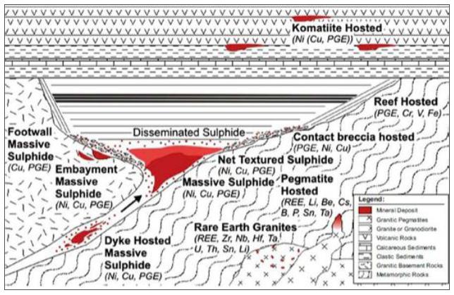
Sources: https://earthsci.org/mineral/mindep/class_dep/class_dep.html
Notes: Exploration at Disko-Nuussuaq primarily targets massive sulphide deposits in the deeper levels shown in this diagram.
Table 6-3: Analogies between Ni, Cu and PGE magmatic deposits and conceptual mineralisation at Disko-Nuussuaq
| Characteristic | Norilsk-Talnakh (Russia) |
Voisey's Bay (Canada) |
Eagle / Eagle East (USA) |
Disko-Nuussuaq (Greenland) | ||||
| Deposit type | Magmatic Ni-Cu-PGE sulphide deposit associated with a Large Igneous Province (“LIP”) | Conduit-hosted magmatic Ni-Cu-Co sulphide deposit | Conduit-hosted magmatic Ni-Cu-Co- PGE sulphide deposit | Magmatic Ni-Cu-Co-PGE sulphide deposit associated with feeder conduits within a LIP | ||||
| Age | Triassic (~250 Ma) | Mesoproterozoic (~1.34 Ga) | Mesoproterozoic (~1.1 Ga) | Palaeogene (~60 Ma) | ||||
|
Tectonic setting |
Siberian Traps LIP | Nain Plutonic Suite | Midcontinent Rift LIP | North Atlantic Igneous Province (NAIP) | ||||
| Host rocks | Gabbro-dolerite intrusions and mafic conduits | Troctolites, gabbros, and ferro-gabbros | Ultramafic peridotites with gabbros and pyroxenites | Mafic-ultramafic intrusions and volcanic sequences contaminated by sedimentary rocks | ||||
| Main mineralisation control | Deep-seated faults and magmatic conduits | Structural corridors and feeder dykes | Rift-related ultramafic conduits | Magmatic feeder conduits in dep-seated faults and crustal contamination |
| SRK EXPLORATION LIMITED ■ JUNE 2026 | 75 |
| Technical Report Summary for the Disko-Nuussuaq Project |
| GEOLOGICAL SETTING AND MINERALISATION |
| Dominant mineralisation style |
Massive, disseminated, and stockwork sulphides |
Massive, brecciated, and disseminated sulphides | Massive and semi- massive sulphides | Massive, net-textured and disseminated sulphides | ||||
| Principal ore minerals | Pentlandite, chalcopyrite, pyrrhotite + PGMs | Pentlandite, chalcopyrite, pyrrhotite | Pentlandite, chalcopyrite, pyrrhotite | Pentlandite, chalcopyrite, pyrrhotite ± cobaltite and PGMs | ||||
| Nickel | Very high | Very high | Very high | Very high | ||||
| Copper | High | High | High | High | ||||
| PGE content | Very high | Low to moderate | Moderate | Moderate to high | ||||
| Expected size | World-class giant deposit | World-class deposit | Smaller tonnage, high-grade deposit | District-scale exploration target | ||||
| Genetic model | Sulphide saturation driven by crustal contamination in a large magmatic system | Sulphide accumulation within conduits and magma chambers | Sulphide accumulation in structural traps within conduits | Closely resembles Norilsk: magma-sediment interaction and sulphide accumulation within feeder conduits | ||||
| Closest analogue | — | Jinchuan, Eagle | Voisey's Bay | Norilsk-Talnakh |
Sources: Lightfoot et al., 2012a, NI 43-101 Technical Report on the Eagle Mine, Michigan, USA, and GEOSCIENCE FRONTIERS 2(4) (2011) 583e591.
Notes: Characteristics for Disko-Nuussuaq are conceptual and intended to show the likely style of mineralisation targeted by exploration.
| 6.7 | Tectonomagmatic, Petrological and Geochemical Framework |
Petrologically, these systems are dominated by cumulative processes, where crystallisation of olivine, pyroxene, and plagioclase produces ultramafic to mafic cumulates that act as hosts to sulphide mineralisation. The presence of cumulate textures is therefore not only a lithological characteristic but also an indicator of sites of magma stagnation and potential sulphide deposition (Barnes, 2023).
The interplay between mantle source characteristics and crustal processes is critical. Most ore-forming systems derive from primitive asthenospheric melts modified by assimilation of crustal material, which simultaneously triggers sulphide saturation and modifies trace element signatures (Barnes, 2023).
According to Lightfoot and Hawkesworth (1997), crustal contamination in the West Greenland Flood Basalt Province occurred when primitive mantle-derived picritic magmas ascended through and interacted with continental crustal rocks and sedimentary sequences before eruption. The evidence indicates that the parental magmas, originally rich in magnesium and chemically similar to those associated with mantle plume activity, assimilated significant amounts of crustal material during their ascent through the crust.
The contamination process was particularly important in the Asuk, Kuugannguaq, and related tholeiitic units of the Vaigat Formation. Geochemical data show that these magmas acquired higher SiO2 contents, elevated La/Sm ratios, increased concentrations of large-ion lithophile elements (LILE), and more crust-like Sr and Nd isotopic signatures. These changes are interpreted as the result of assimilation of continental crustal rocks and sedimentary material by the ascending magmas.
| SRK EXPLORATION LIMITED ■ JUNE 2026 | 76 |
| Technical Report Summary for the Disko-Nuussuaq Project |
| GEOLOGICAL SETTING AND MINERALISATION |
Lightfoot and Hawkesworth propose that at least two distinct crustal contaminants were involved. One contamination trend reflects interaction with sedimentary material, probably hydrocarbon-rich shales, characterised by elevated Th/La ratios and strongly crustal isotopic signatures. A second trend is interpreted to reflect contamination by Proterozoic igneous or metamafic crustal rocks, producing high La/Sm and Zr/Y ratios but less pronounced Th enrichment. These observations demonstrate that contamination was not produced by a single crustal source but by several crustal lithologies present beneath the volcanic province.
A crucial consequence of this contamination was the increase in magma silica content. Lightfoot and Hawkesworth argue that the assimilation of approximately 20–25% crustal material increased the SiO2 content by about 5 wt%, thereby reducing sulphur solubility in the magma. Once sulphur saturation was reached, an immiscible sulphide liquid separated from the silicate magma. This sulphide liquid preferentially scavenged nickel, copper, and platinum-group elements (PGE), producing the strong depletion in these metals observed in the contaminated lavas.
The contaminated tholeiitic units, therefore, record a multistage process involving:
| § | ascent of primitive picritic magma from the mantle, | |
| § | assimilation of crustal and sedimentary material, | |
| § | enrichment in SiO2 and incompatible elements, | |
| § | attainment of sulphur saturation, and | |
| § | segregation of sulphide liquids that removed Ni, Cu, and PGE from the magma. |
This process explains the distinctive geochemical signatures of the contaminated West Greenland tholeiites and their association with sulphide mineralisation. The Figure 6-17 shows that the most contaminated lavas (high La/Sm) are also the most Cu-depleted (low Cu/Zr), which constitutes the main geochemical evidence that cortical contamination triggered sulphur saturation and sulphide segregation in West Greenland.
| SRK EXPLORATION LIMITED ■ JUNE 2026 | 77 |
| Technical Report Summary for the Disko-Nuussuaq Project |
| GEOLOGICAL SETTING AND MINERALISATION |
Figure 6-17: Crustal Contamination in West Greenland
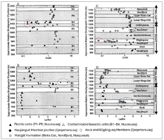
Sources: Lightfoot and Hawkesworth, 1997
Notes: Diagrams A and B correspond to the Nuussuaq sequence, whilst diagrams C and D correspond to Qeqertarsuaq (Disko Island). The red circle indicates lower Cu/Zr ratios, suggesting sulphide segregation. The blue circle indicates higher La/Sm ratios, suggesting greater cortical contamination.
These deposits are commonly situated in Large Igneous Provinces (“LIPs”) or rift-related settings, where mantle plume activity generates large volumes of high-temperature magma. Such environments provide the necessary conditions for:
| § | High magma flux; |
| § | Sustained conduit activity; and |
| § | Extensive interaction between magma and crust. |
In the case of Greenland, including Disko-Nuussuaq, plume-related magmatism linked to the opening of the North Atlantic represents a classic example of this metallogenic setting.
| SRK EXPLORATION LIMITED ■ JUNE 2026 | 78 |
| Technical Report Summary for the Disko-Nuussuaq Project |
| GEOLOGICAL SETTING AND MINERALISATION |
| 6.8 | Conduit Model |
The conduit (feeder-related) model is widely considered the primary genetic framework for magmatic Ni–Cu–PGE sulphide mineralisation in LIPs, including the Disko region of West Greenland. In this model, mineralisation forms within dynamic magma transport pathways (dykes, sills, and feeder conduits) that link deep magma reservoirs to surface volcanic sequences (Figure 6-18).
In conduit systems, the key processes controlling ore formation include:
| § | High magma flux and open-system dynamics: Continuous magma replenishment allows repeated interaction between sulphide liquids and silicate magma, enhancing metal tenors; |
| § | Sulphur assimilation: Interaction with crustal lithologies introduces sulphur, triggering sulphide immiscibility; |
| § | Transport of sulphide droplets: Dense sulphide liquids are entrained and transported within flowing magma; |
| § | Hydrodynamic trapping: Sulphides accumulate in structural or morphological traps such as: |
| – | Embayments; |
| – | Widened conduit segments; and |
| – | Basal contacts of intrusions. |
One of the most important advances in the understanding of magmatic Ni–Cu–PGE sulphide deposits is the recognition that the world's largest ore accumulations are commonly associated with magma conduit systems rather than large, layered intrusions. Research on deposits such as Norilsk, Voisey's Bay, Jinchuan and Pechenga demonstrates that relatively small mafic–ultramafic intrusions can host exceptionally large metal endowments because they form part of extensive and dynamic magma plumbing systems.
The key factor is that magma conduits function as open magmatic systems, through which very large volumes of mantle-derived magma are repeatedly transported. Although the final ore-bearing intrusion may occupy only a few cubic kilometres, the total volume of magma that passed through the conduit during its lifetime may be several hundred to several thousand cubic kilometres. This continuous magma throughput allows the conduit to act as an efficient collector and concentrator of immiscible sulphide liquids.
Mass balance calculations from world-class deposits illustrate this process. The Norilsk–Talnakh deposits contain ore hosted within relatively thin sill-like intrusions. Yet, the metal inventory indicates that approximately 1,000 km3 of basaltic magma must have passed through the conduit system to supply the observed quantities of nickel, copper, and platinum-group elements. Similarly, the Jinchuan deposit is hosted within an intrusion of approximately 1 km3, but its nickel endowment suggests that roughly 300 km3 of magma circulated through the system during ore formation.
The economic potential of a target is not necessarily related to the size of the exposed intrusion, but rather to its capacity to have acted as a long-lived conduit through which large volumes of fertile picritic magma were transported. Features such as conduit widening, embayments, flow restrictions and magma–sediment interaction zones therefore represent priority exploration targets, as they provide the most favourable settings for the concentration of large-volume Ni–Cu–PGE sulphide mineralisation (Song et al., 2011).
| SRK EXPLORATION LIMITED ■ JUNE 2026 | 79 |
| Technical Report Summary for the Disko-Nuussuaq Project |
| GEOLOGICAL SETTING AND MINERALISATION |
In summary, conduit systems can generate giant Ni–Cu–PGE deposits by acting as metal-collection and concentration pathways within regional magma plumbing systems. The largest deposits form where prolonged magma flow, sulphide saturation, and efficient hydrodynamic trapping operate together, allowing a relatively small intrusion to accumulate metals derived from hundreds to thousands of cubic kilometres of mantle-derived magma.
Figure 6-18: Conduit Model for Magmatic Sulphide Deposits
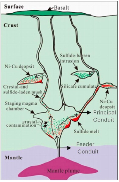
Sources: SRK EX. Modified from Wang, et al., 2017
In Disko-Nuussuaq, the conduit model is supported by:
| § | The presence of dyke–sill complexes feeding Paleogene flood basalts: | |
| § | Evidence for contamination of magmas by sedimentary units; and | |
| § | Occurrence of sulphide mineralisation in feeder-style intrusions. |
| SRK EXPLORATION LIMITED ■ JUNE 2026 | 80 |
| Technical Report Summary for the Disko-Nuussuaq Project |
| GEOLOGICAL SETTING AND MINERALISATION |
| 6.9 | Disko Model Interpretations |
In the West Greenland Flood Basalt Province, of which the Nuussuaq Peninsula and Disko Island are part, the entire Vaigat Formation is present and comprises one of the largest volumes of picritic MgO-rich lavas known globally. It has also been documented that basaltic and picritic magmas have undergone contamination by sedimentary rocks and reached sulphur saturation. Two members of the lower part of the Vaigat Formation have significant volume and underwent contamination (Larsen and Pedersen, 2009). These magmas ascended along focused magma conduits, likely distributed along the N-S Kuugannguaq-Quinnlik fault system (Dam et al., 2009) (Figure 6-4). These conduits host native iron and Fe-Ni-Cu-Co-sulphide occurrences, suggesting potential for massive Ni sulphide deposits. The sulphur saturation, however, likely took place at relatively high levels of the crust. Dykes therefore remain an avenue for further field examination and sampling.
In the 1930s, a 28 ton boulder of massive nickel sulphide was reportedly found next to or extracted from the Igdlukunguaq Dyke on northeast Disko Island. The ore mineral is nickeliferous pyrrhotite. The nickel content of the boulder varied from 1.91 to 4.72%, and the copper content from 0.80 to 2.35%.
The genesis of the Igdlukunguaq dyke and mineralisation has been described by Pauly (1958). Although Pauly (1958) interpreted the nickeliferous pyrrhotite in the Igdlukunguaq boulder as the product of crystallisation and subsequent exsolution processes within a sulphide-rich dyke, more recent exploration models suggest that the occurrence may represent part of a larger conduit-hosted magmatic Ni–Cu sulphide system. Alternative genetic mechanisms include sulphide immiscibility triggered by contamination from sulphur-rich sedimentary rocks, accumulation of sulphide liquids within magma conduits, or remobilisation and concentration of sulphides generated at deeper levels of the magmatic plumbing system. Consequently, the Igdlukunguaq occurrence is now commonly viewed within the broader framework of the Disko–Nuussuaq conduit-type magmatic sulphide province rather than as an isolated sulphide body.
It should also be noted that the boulder may not be related to the dyke that it was found next to. It may have been transported to the area as part of a rockslide of the basalts in the high ground to the south. Interpretations of its relationship to the Igdlukunguaq dyke could therefore be misleading.
Several lines of evidence indicate that the Disko–Nuussuaq region possesses the key characteristics of a conduit-style magmatic sulphide province comparable to globally significant systems such as Norilsk, Voisey’s Bay and Jinchuan. GEUS classified the Ni–Cu–PGE potential of Disko under the category of deposits related to picritic and tholeiitic dyke-sill complexes, or conduit-type deposits, rather than classical komatiite-hosted deposits. This interpretation is based on the presence of high-volume mantle-derived picritic magmatism, extensive magma throughput, evidence of sulphide saturation, and the occurrence of Ni–Cu–Co-bearing sulphides associated with feeder intrusions and volcanic plumbing systems. Subsequent studies have highlighted the sediment-contaminated nature of this dyke and interpreted it as part of a larger magmatic conduit system capable of transporting and concentrating sulphide liquids.
The widespread evidence for magma–sediment interaction throughout the Vaigat Formation provides a highly favourable mechanism for triggering sulphide immiscibility. Organic-rich sedimentary rocks and sulphur-bearing lithologies are thought to have supplied external sulphur to ascending magmas, promoting the segregation of dense sulphide liquids capable of concentrating Ni, Cu, Co and PGE. This process is regarded as analogous to the contamination-driven sulphide saturation model proposed for several major conduit-hosted deposits worldwide.
| SRK EXPLORATION LIMITED ■ JUNE 2026 | 81 |
| Technical Report Summary for the Disko-Nuussuaq Project |
| GEOLOGICAL SETTING AND MINERALISATION |
Deeper feeder conduits, fault-focused magma pathways and intrusive embayments associated with the Kuugannguaq–Qunnilik structural corridor remain priority targets for the discovery of economically significant massive Ni–Cu–PGE sulphide accumulations.
| 6.9.1 | Importance of strike-slip margins |
In conduit-style magmatic nickel deposits, long-lived strike-slip faulting related to passive rifting or plume-initiated active rifting is known to generate deep-rooted structural zones which can control the migration of magma (Lightfoot, 2015). Within a strike-slip system, there are classic restraining and releasing bends generating compressive (transpressive) and releasing (transtensive) zones of displacement. It is the releasing, pull-apart systems that produce both vertical and lateral displacement zones that can provide an opportunity for magma to travel. Magma migration in these situations is said to be non-uniform and episodic. Lightfoot (2015) describes how intrusions in these environments are commonly funnel-shaped in cross-section and rhombic in plan view, consistent with development in zones of transtension and reflecting the anisotropy of the country rocks.
Strike-slip margins may play a critical role in the formation and localisation of magmatic Ni–Cu– PGE sulphide deposits in Disko-Nuussuaq. These tectonic environments provide the structural architecture and dynamic conditions necessary for magma transport, sulphide segregation, and ore accumulation (Figure 6-19).
As a result, they represent a first-order control on the localisation, geometry and economic potential of Ni–Cu–PGE mineralisation in the Disko-Nuussuaq region and must be considered a primary focus in both geological interpretation and exploration targeting.
| SRK EXPLORATION LIMITED ■ JUNE 2026 | 82 |
| Technical Report Summary for the Disko-Nuussuaq Project |
| GEOLOGICAL SETTING AND MINERALISATION |
Figure 6-19: Kuugannguaq–Qunnilik (K–Q) Fault
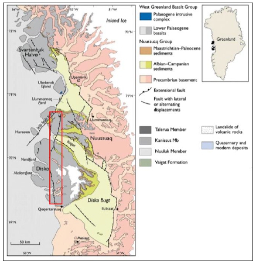
Sources: SRK EX. Modified after Dam et al. (2009) and Schmidt et al. (2005)
Notes: Red square: K-Q Fault extets.
| 6.9.2 | Relationship of Ni Deposits to Large Igneous Provinces |
Magmatic nickel and PGE deposits form in a variety of deposit styles and times. However, studies including those of Lightfoot (2015), and Maier and Groves (2011), highlight an important temporal correlation with superplume activity and the formation of LIPs. In fact, studies of known nickel resources and dating of their host intrusions reveal that most magmatic nickel deposits are temporally linked to the formation of LIP events that follow continental break-up immediately following the development of superplume activity (Lightfoot, 2015).
Magmatic nickel sulphide deposits tend to be concentrated within lava channels and magma conduits occurring at craton margins where mantle plume activity is concentrated and channelled through very deep-seated (translithospheric) structures. The magma flow is focused in these areas and periodically shifted by compressive-transpressive environments. Further, sulphur-rich crustal rocks provide the sulphur required. Maier and Groves (2011) summarise deposit geometry as irregular and small, between tens and hundreds of metres in width and height, and are relatively difficult to locate.
| SRK EXPLORATION LIMITED ■ JUNE 2026 | 83 |
| Technical Report Summary for the Disko-Nuussuaq Project |
| GEOLOGICAL SETTING AND MINERALISATION |
The association of Ni–Cu–PGE deposits with LIPs is central to the exploration model for Disko-Nuussuaq. LIP magmatism provides:
| § | Fertile, high-temperature magmas capable of transporting metals; | |
| § | High magma flux and dynamic conduit systems required for sulphide transport; | |
| § | Tectonic and stratigraphic conditions favourable for sulphur assimilation; and | |
| § | A vertically integrated plumbing system allowing mineralisation at multiple levels. |
In Disko, these factors collectively support a large-scale, conduit magmatic system, significantly enhancing the prospectivity for Ni–Cu–PGE mineralisation and guiding exploration towards both conduit-hosted and lava-related targets.
| 6.10 | Norilsk Deposit Analogy |
The Norilsk–Talnakh deposits represent a world-class example of magmatic Ni–Cu–PGE sulphide mineralisation associated with mafic–ultramafic intrusions emplaced within a LIP, specifically the Permo–Triassic Siberian Traps. These deposits are best described as conduit-related, intrusion-hosted sulphide systems, where mineralisation is concentrated within relatively sill-shaped intrusive bodies emplaced into sedimentary sequences rather than within large, layered intrusions (Starostin and Sorokhtin, 2011; Figure 6-20).
Genetically, the Norilsk deposits formed within an open magmatic system, in which ascending mantle-derived magmas interacted extensively with crustal rocks during emplacement. This interaction played a critical role in triggering sulphide immiscibility, leading to the segregation of dense sulphide liquids that efficiently scavenged chalcophile elements such as nickel, copper and PGEs.
The Norilsk region includes several deposits: Oktyabrsky, Talnakh, and Norilsk-1. Barnes et al. (2020) reported the resource from 2019 at 2.14 billion tonnes at 0.72% Ni, 1.39% Cu, 4.91 g/t PGE, and 0.22 g/t Au, containing approximately 15.5 Mt Ni, 29.8 Mt Cu, 337 Moz PGE, and 15 Moz Au. It is accepted that whilst the grades are not exceptional, the tonnage is very large.
At Norilsk, mineralisation is unequivocally linked to subvolcanic conduit-style intrusions emplaced within sedimentary sequences, where ascending mantle-derived magmas interact extensively with crustal rocks. A defining feature of this system is the dominant role of crustal assimilation and recycling, whereby sulphur and a significant proportion of metals (Ni, Cu, PGE) are sourced from Proterozoic sediments and basement rocks. This interaction triggers sulphide immiscibility, leading to the formation and accumulation of high-grade sulphide bodies at the base of intrusions and within exocontact zones (Starostin and Sorokhtin, 2011).
| SRK EXPLORATION LIMITED ■ JUNE 2026 | 84 |
| Technical Report Summary for the Disko-Nuussuaq Project |
| GEOLOGICAL SETTING AND MINERALISATION |
Figure 6-20: Norlisk Deposit Model
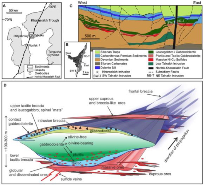
Sources: https://doi.org/10.1130/G51359.1
Notes: (A) Location map. (B–C) Long section through Kharaelakh (K) and Talnakh (T) intrusions. (D) Schematic three-dimensional view of a “composite” Norilsk-Talnakh chonolith complex, showing internal differentiation, disposition of ore types, and flanking sills
The Disko–Nuussuaq Province of West Greenland is widely regarded as one of the closest geological analogues to the Norilsk–Talnakh. Although no economic sulphide deposit comparable in size to Norilsk has yet been discovered in Greenland, both regions share a set of geological, magmatic and metallogenic characteristics that support the application of a conduit-hosted Ni–Cu– PGE exploration model.
A fundamental similarity is that both provinces are associated with Large Igneous Provinces (LIPs) generated during episodes of continental rifting and voluminous mantle-derived magmatism. The Norilsk deposits are linked to the Siberian Traps flood basalt event, whereas the Disko–Nuussuaq mineral system is associated with the Paleogene West Greenland Flood Basalt Province. In both cases, extensive volumes of primitive picritic and basaltic magma were emplaced through regional crustal-scale plumbing systems.
| SRK EXPLORATION LIMITED ■ JUNE 2026 | 85 |
| Technical Report Summary for the Disko-Nuussuaq Project |
| GEOLOGICAL SETTING AND MINERALISATION |
Another important feature common to both districts is the presence of high-throughput magma conduits. Studies of Norilsk have demonstrated that the ore-bearing intrusions themselves are relatively small compared with the enormous volumes of magma that passed through the conduit system. Large metal accumulations formed because sulphide liquids were repeatedly flushed by new magma pulses, allowing efficient collection of nickel, copper, and platinum-group elements. The conduit-hosted exploration model currently applied at Disko is based on the same principle, namely that exposed dykes and intrusions may represent only the upper expression of a much larger and more extensive magma transport system.
To explore for a Norilsk-style system at Disko-Nuussuaq requires:
| § | Discovery of magma feeder conduits, with evidence of sustained and substantial magmatic throughput; |
| § | Emplacement into sedimentary packages; |
| § | Recognition of the potential for multi-level mineralisation (intrusive); |
| § | Sulphur contamination; |
| § | Evidence of sulphide segregation in the host intrusions; and |
| § | Use of geochemistry to identify fertile magmatic suites associated with plume activity. |
| 6.10.1 | Crustal Contamination Analogy |
The main geochemical similarity between the two regions is that the magmas most contaminated by the crust show a marked depletion in nickel (Ni), copper (Cu), and platinum group elements (PGEs). At the same time, these magmas have higher silica (SiO2) contents, elevated La/Sm ratios and isotopic signatures indicative of crustal contamination. This relationship suggests that the interaction between mantle magmas and the crust favoured the segregation of sulphide-bearing fluids capable of efficiently extracting chalcophile and siderophile metals from the magma.
In both regions, the assimilation of approximately 20 to 25% of crustal material raised the SiO2 concentration sufficiently to reduce the solubility of sulphur and trigger the formation of immiscible sulphides. This implies that even low-sulphur-content contaminants, such as granodioritic rocks, were able to initiate the mineralisation process.
This Figure 6-21 compares the volcanic sequences of Noril’sk (top panel) and West Greenland (bottom panel). The aim is to illustrate the relationship between cortical contamination and copper depletion caused by sulphide segregation.
In the data from West Greenland, particularly in the Maligât, Asuk-Kuugannguaq and BO-B4 units, a clear decrease in the Cu/Zr ratio is observed as the SiO2 and La/Sm values increase. This behaviour is characteristic of cortical contamination, as the incorporation of cortical material into the magma increases the silica content and enriches the incompatible light rare-earth elements (increasing La/Sm), whilst progressively diluting the signal of chalcophile elements such as copper, causing a drop in the Cu/Zr ratio. The picrites of the Vaigat Formation (black triangles and filled circles) represent the most primitive compositions and exhibit high Cu/Zr ratios (≈1.5–3), consistent with a poorly modified mantle origin.
| SRK EXPLORATION LIMITED ■ JUNE 2026 | 86 |
| Technical Report Summary for the Disko-Nuussuaq Project |
| GEOLOGICAL SETTING AND MINERALISATION |
This figure therefore provides strong geochemical evidence that the magmas of West Greenland underwent progressive contamination by continental crust during their ascent and differentiation.
Figure 6-21: Crustal Contamination into volcanic sequences of Norlisk and West Greenland
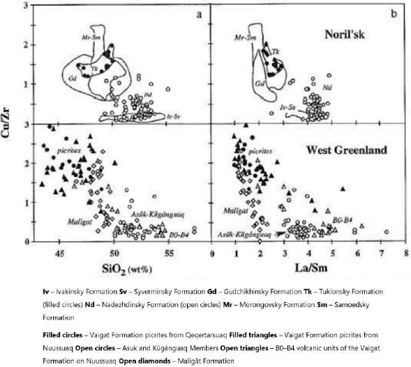
Sources: Lightfoot and Hawkesworth, 1997
Notes: (a) Variation of Cu/Zr ratios versus SiO2 contents in samples from the Siberian Traps (data from Lightfoot et al., 1990, 1993, 1994; in preparation; Wooden et al., 1993; Hawkesworth et al., 1995) and the West Greenland Continental Flood Basalt (CFB) province (data from Lightfoot et al., in press).
(b) Plot of Cu/Zr ratios versus La/Sm ratios for samples from the Siberian Traps (data from Lightfoot et al., 1993, in preparation; Wooden et al., 1993; Hawkesworth et al., 1995) and the West Greenland Continental Flood Basalt (CFB) province (data from Lightfoot et al., in press).
| SRK EXPLORATION LIMITED ■ JUNE 2026 | 87 |
| Technical Report Summary for the Disko-Nuussuaq Project |
| EXPLORATION |
| 7 | EXPLORATION |
This section summarises exploration undertaken on the Disko-Nuussuaq project since 2017, during which time in which Bluejay Mining, 80 Mile, and KoBold Metals have operated under the licence ownership of Nikkeli A/S. Table 7-1 summarises the exploration undertaken by each organisation since 2017.
All activity prior to 2017 is documented in Section 5.
| Table 7-1: | Recent exploration undertaken under Nikkeli A/S licence ownership |
| Organisation | Year Involved | Exploration Undertaken |
| 80 Mile PLC (formerly Bluejay pre-2024) | 2017 – Present | § MLEM survey over Kuugannguaq & Titan24 Reprocessing to refine drill targets § MMI/SGH Soil Sampling ~3,000 data points (2019) § Geological mapping and reconnaissance – several indications of previously unknown mineralisation found § MULSEDRO Drone Magnetic Survey |
| KoBold Metals | JV 2022 - 2023 | § Falcon airborne gravity surveys § Ground SAMSON and HeliSAM EM surveys § UAV magnetics § MMI Soil geochemistry § Geological Mapping § Grab sampling |
| 7.1 | Geological Mapping |
Geological mapping undertaken by Nikkeli A/S since 2017 focussed on key areas in each licence. This was generally conducted alongside rock/grab sampling on outcrop and boulders.
| 7.1.1 | 2019 Activities |
MEL 2017-01
Geological mapping targeted areas identified during desktop reconnaissance in 2018 and 2019, close to the Igdlukunguaq area. The aim of the programme was to understand the target areas for future exploration activities and use reprocessed geophysical data to understand the sources of geophysical anomalies. This being the area of the famous 28 t sulphide boulder, geologists aimed to identify further such boulders during the programme but were not successful.
This programme highlighted the need for a high-resolution ground magnetic survey over the licence.
| SRK EXPLORATION LIMITED ■ JUNE 2026 | 88 |
| Technical Report Summary for the Disko-Nuussuaq Project |
| EXPLORATION |
MEL 2018-16
Geological mapping in MEL 2018-16 focussed on a few specific targets on the northeast of Disko Island. The mapping programme identified several rusty outcrops approximately 5 km southeast of Qullissat of fine grained mafic intrusives with some very fine grained sulphides. These outcrops are interpreted to correspond to a 2 km long magnetic anomaly in the area.
A significant outcome of the mapping campaign was the discovery of several mineralised outcrops approximately 5 km southeast of Qullissat, referred to as the Delta Mineralisation. These outcrops occur close to historic Falconbridge drill holes FP-94-5 and FP-94-6 and consist of a fine-grained mafic intrusion containing disseminated sulphides, including pyrrhotite and chalcopyrite, developed along fracture planes. The mineralisation is spatially associated with a ground magnetic anomaly extending for at least 2 km, suggesting a potentially significant mineralised system that warrants further investigation. A 20 m-wide zone contained malachite, pyrite and pyrrhotite.
A second important mineralised occurrence, named the Ujarassuit Mineralisation, was discovered approximately 15 km southeast of Qullissat near the eastern contact of the Ujarassuit lava flow. Geological observations identified a rusty mineralised zone, approximately 20 m wide, exposed within a small creek. The zone contains pyrite, pyrrhotite, and secondary copper minerals such as malachite, indicating sulphide mineralisation and possible copper enrichment. Bluejay recommended detailed follow-up mapping to determine the extent and continuity of this mineralised zone, particularly beneath and beyond the lava flow cover.
In addition, geological mapping identified a strongly weathered siltstone–mudstone horizon beneath a fine-grained mafic intrusive body approximately 3.5 km northwest of Qullissat. Although the lateral extent of this sedimentary unit could not be effectively traced, the observation is considered noteworthy because such sedimentary horizons may represent favourable stratigraphic environments for magmatic sulphide accumulation.
| 7.1.2 | 2022 Activities |
Work in 2022 involved high resolution geological mapping conducted on five separate areas in licences MEL 2017-01, MEL 2024-30, MEL 2018-16, MEL 2019-116 and MEL 2019-116. These identified various lithological contacts and faults in the Qullissat (Figure 7-1), Igdlukunguaq (Figure 7-2), Hammer Dal, Aaffarsuaq and Itilli areas, presented on a series of maps within the field reports.
| SRK EXPLORATION LIMITED ■ JUNE 2026 | 89 |
| Technical Report Summary for the Disko-Nuussuaq Project |
| EXPLORATION |
Figure 7-1: Geological map of the Qullissat area in MEL 2018-16
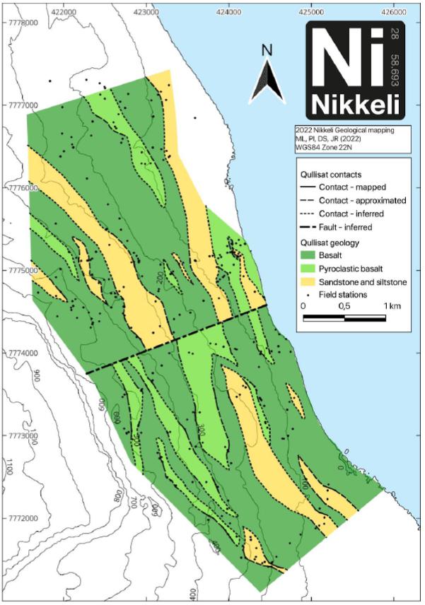
Sources: Illeg, 2023 (MEL 2018-16)
| SRK EXPLORATION LIMITED ■ JUNE 2026 | 90 |
| Technical Report Summary for the Disko-Nuussuaq Project |
| EXPLORATION |
Figure 7-2: Geological map of the Igdlukunguaq area in MEL 2017-01
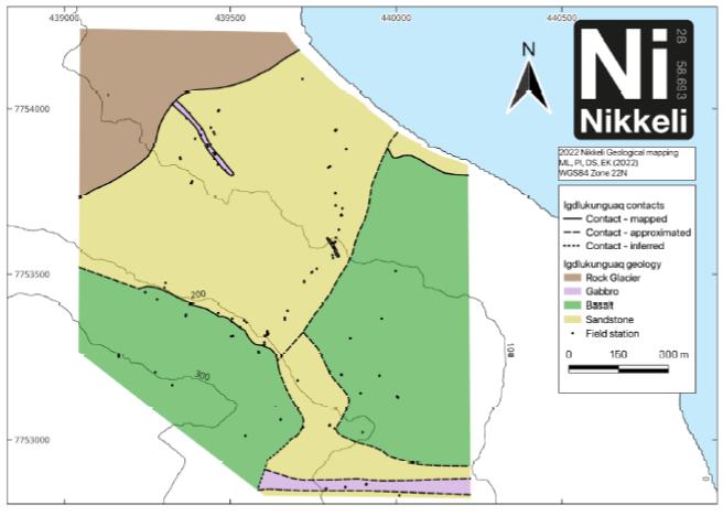
Sources: Illig et al., 2023 (MEL 2017-01)
A total of six stratigraphic sections were produced for some of the outcrop locations (Figure 7-3), highlighting the relationship between later intrusives and sedimentary lithologies.
| SRK EXPLORATION LIMITED ■ JUNE 2026 | 91 |
| Technical Report Summary for the Disko-Nuussuaq Project |
| EXPLORATION |
Figure 7-3: Stratigraphic section near Igdlukunguaq
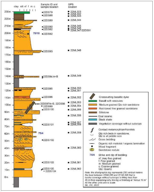
Sources Illig et al., 2023 (MEL 2017-01)
| SRK EXPLORATION LIMITED ■ JUNE 2026 | 92 |
| Technical Report Summary for the Disko-Nuussuaq Project |
| EXPLORATION |
MEL 2012-29
Two stratigraphic sections were mapped highlighting silt and sandstones overlying basalts in the northern slope of the Aaffarsuaq Valley on the Nuussuaq Peninsula.
The mapped sections are described below:
| § | A section of approximately 275 m was mapped at GPS position 22DS26: UTM 404503, 7820185 |
| § | A section of approximately 700 m was mapped at GPS location 22DS40: UTM 408306, 7821023. |
MEL 2017-01
Geological mapping was conducted around Igdlukunguaq which identified contacts between gabbro, basalt and sandstone. A descriptive stratigraphic log of 230 vertical metres was mapped near Igdlukunguaq displaying the relationship of the dyke with surrounding formations (Figure 7-3). Additionally, a section was mapped on the northern shore of Disko Island, south of Qullissat at about 58 m at the GPS location 22DS104: UTM 439820, 7753936. This section was cross-cut by a series made up of sandstone-siltstone with black shale intercalation.
MEL 2018-16
Geological mapping was carried out in the area around Qullissat and the Aaffarsuaq Valley. Three additional smaller stratigraphic sections of profiles were created:
| § | A section was mapped at the southern slope of the Aaffarsuaq Valley on the Nuussuaq Peninsula at about 371 m at the GPS location 22DS16: UTM 401905, 7815545. This section was cross-cutting interbedded sandstone with mudstone. |
| § | A section was mapped at the southern slope of the Aaffarsuaq Valley on the Nuussuaq Peninsula at about 507 m at the GPS location 22DS06: UTM 402898, 7815096. This section was cross-cutting sedimentary rocks at the bottom of the section and ended in the pyroclastic basalt. |
| § | A section was mapped on the northern shore of Disko Island, south of Qullissat at about 64 m at the GPS location 22DS65; UTM 426454, 7769755. This section was cross-cutting a series made up of sandstone and black shale with a small cross-cutting basaltic sill. |
MEL 2019-116
Geological mapping was carried out around Hammer Dal on Disko Island and the Itilli Valley on the Nuussuaq Peninsula. In addition, geological mapping was carried out in the Serfat area, on the northern coast of the Nuussuaq Peninsula; although no maps were produced, the observations made at the field station were recorded.
MEL 2020-10
No geological mapping or soi sampling was undertaken on this licence in 2022.
| SRK EXPLORATION LIMITED ■ JUNE 2026 | 93 |
| Technical Report Summary for the Disko-Nuussuaq Project |
| EXPLORATION |
| 7.1.3 | SRK Comment |
The surface geology of the project area seems generally well understood and is based on GEUS’s vectorised 1:500,000 scale geological map of the area from 2013. This dataset identities the distribution of the Vaigat Formation, individual members within the Maligât Formation, as well as the gneissic basement and Cretaceous sediments. High resolution mapping in key areas by Nikkeli has further enhanced this understanding.
| 7.2 | Geophysics |
Acquisition of new geophysical data on Disko and Nuussuaq and reprocessing of historical data has been a major focus of work since 2019 and now forms an important part of exploration targeting.
| 7.2.1 | 2019 Activities |
During the 2019 field season, 80 Mile commissioned Quantec Geoscience Ltd. to reprocess and re-invert Titan-24 DCIP/MT (resistivity, induced polarisation/magnetotelluric) data originally collected in 2003 and 2004 on behalf of Vismand Exploration. A total of 14 lines (104.3 km) of data over six areas were reprocessed (Figure 7-4). This covers portions of exploration licences MEL 2012-29, MEL 2018-16, MEL 2019-116 and MEL 2017-01. Information on the original survey is detailed in section Geophysical Surveys in 2003–20045.6.1 and Figure 5-9.
| SRK EXPLORATION LIMITED ■ JUNE 2026 | 94 |
| Technical Report Summary for the Disko-Nuussuaq Project |
| EXPLORATION |
Figure 7-4: Titan-24 DCIP/MT Survey acquisition layout
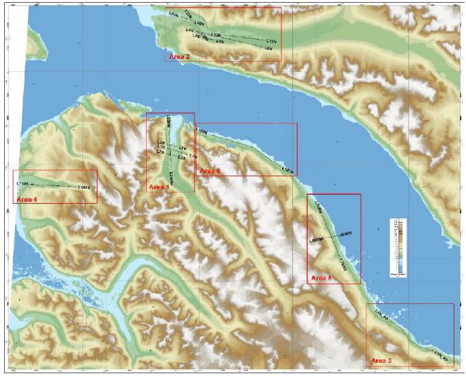
Sources: 80 Mile PLC
Notes: Survey lines are those acquired for Vismand in 2003 and 2004 and are depicted in Exploration History.
Deliverables of the commission included 2D model sections for each line of DC resistivity, IP chargeability, MT resistivity models, model plan maps and associated raw data. The reprocessing is reported to have improved the quality of models that were originally delivered. SRK EX has not received any documented interpretation of this work.
One outcome of this was confirmation of an IP anomaly in the Aaffarsuaq Valley on survey line L10N which was targeted by Vismand in their V-GRN-1, -1A and -2 drillholes, although these never reached bedrock. The top of this anomaly is at a depth of about 300 m. SRK EX has reviewed this section (Figure 7-5) and cautions that the chargeabililty anomaly appears to be within a horizon with low IP effect, suggesting that there may be a chargeable horizon within the sediments, rather than a sulphide body. That said, the anomaly does coincide with a feature in Kobold’s Falcon gravity data and this may be worthy of follow-up work.
| SRK EXPLORATION LIMITED ■ JUNE 2026 | 95 |
| Technical Report Summary for the Disko-Nuussuaq Project |
| EXPLORATION |
Figure 7-5: Titan-24 IP inversion for line L10N in the Aaffarsuaq Valley

Sources: 80 Mile PLC
Notes: The chargeable feature of interest is represented by the yellow/orange colours in the centre of the section.
| 7.2.2 | 2022 Activities |
Under the JV with KoBold in 2022, a variety of geophysical surveys were carried out on the licences including:
| § | Bathymetry – Conducted by HydroCharting using a sonic 2024 multibeam echosounder and sidescan sonar; |
| § | Airborne gravity gradiometry and magnetics – Conducted by Xcalibur Multiphysics using their Falcon system. Raw data and processed maps were delivered to Bluejay. |
| § | UAV magnetics – Two drone-borne magnetic surveys were collected by EarthEx Geophysical Solutions. |
| § | Helicopter and ground sub-audio magnetics (SAM) – Conducted by Discovery International Geophysics in collaboration with Gap Geophysics. The HeliSAM data was collected at a frequency of 2.5 Hz. The ground sub-audio magnetic (SAMSON) data were collected at a frequency of 0.125 Hz. Ground electromagnetics was also undertaken in some locations. |
Table 7-2 summarises the licences and corresponding geophysical method undertaken.
| SRK EXPLORATION LIMITED ■ JUNE 2026 | 96 |
| Technical Report Summary for the Disko-Nuussuaq Project |
| EXPLORATION |
Table 7-2: Geophysical methods conducted over Disko and Nuussuaq Licences
Licence |
Bathymetry [Figure 7-6] |
Xcalibur
Airborne [Figure 7-7] |
EarthEx
UAV- [Figure 7-8] |
Discovery Int’l
and Gap Geophysics Helicopter and ground sub-audio magnetics (SAM) [Figure 7-9] | ||||
| MEL 2017-01 (Qullissat) |
N/A |
148 line km One survey area 200 m line spacing 100 m target terrain clearance |
202.3 line km 50 m line spacing 25 m terrain clearance | HeliSAM: 135.3 line km One survey area 75 m line spacing SAMSON: 103 stations 100
m station | ||||
| MEL 2012-29 (Kuugannguaq and Aaffarsuaq Valleys) |
8.05 km2 survey area | 693 line km Four survey areas (3 areas flown at 200 m, one flown at 150m line spacing) 100 m target terrain clearance | 1,335 line km 50 m line spacing 25 m terrain clearance | HeliSAM: 590 line km Six survey areas 100 m line spacing SAMSON: 2 survey areas 82 stations 100 m station spacing. | ||||
| MEL 2018-16 (Aaffarsuaq Valley and Qullissat areas) |
29.2 km2 survey area | 1,498 line km Five survey areas 200 m line spacing 100 m target terrain clearance | 596 line km 50 m line spacing 25 m terrain clearance | HeliSAM: 337 line km Six survey areas 75 m, 100 m or 150 m line spacing SAMSON: 3 survey areas 421 stations 100 m line spacing. | ||||
| MEL 2019-116 (Itilli Valley) |
N/A | 676 line km Three survey areas (2 areas at 200 m line spacing, one at 150 m). 100 m target terrain clearance | N/A | N/A | ||||
| MEL 2020-10 | N/A | N/A | N/A | N/A |
Sources: SRK EX, 2026. Source data from Illig et al, 2023
| SRK EXPLORATION LIMITED ■ JUNE 2026 | 97 |
| Technical Report Summary for the Disko-Nuussuaq Project |
| EXPLORATION |
Figure 7-6: Bathymetry survey
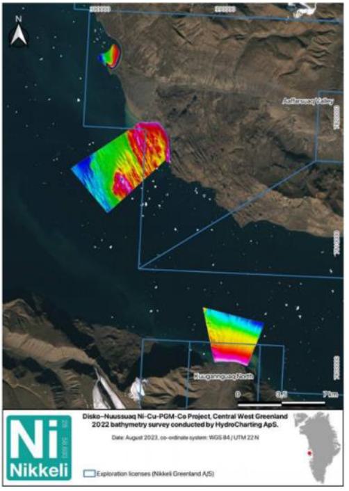
Sources: Bluejay, 2023
| SRK EXPLORATION LIMITED ■ JUNE 2026 | 98 |
| Technical Report Summary for the Disko-Nuussuaq Project |
| EXPLORATION |
Figure 7-7: Xcalibur Airborne gravity gradiometry and magnetics
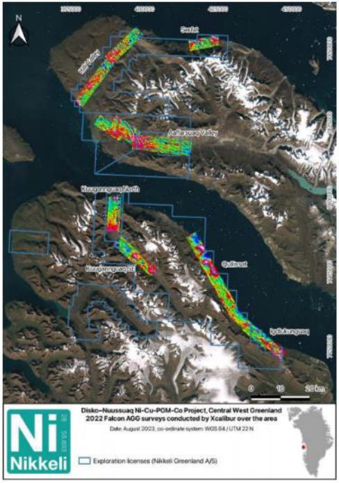
Sources: Bluejay, 2023
| SRK EXPLORATION LIMITED ■ JUNE 2026 | 99 |
| Technical Report Summary for the Disko-Nuussuaq Project |
| EXPLORATION |
Figure 7-8: EarthEx UAV-borne magnetic surveys
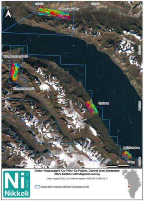
Sources: Bluejay, 2023
| SRK EXPLORATION LIMITED ■ JUNE 2026 | 100 |
| Technical Report Summary for the Disko-Nuussuaq Project |
| EXPLORATION |
Figure 7-9: HeliSAM helicopter-borne electromagnetic surveys
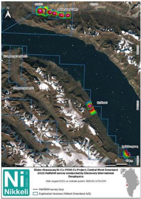
Sources: Bluejay, 2023
Falcon AGG Surveys
SRK EX understands that a thorough, reported interpretation of the geophysical results has not yet been undertaken. KoBold has carried out a detailed in-house modelling of the AGG and magnetic data. Several positive gravity anomalies associated with known targets (for example, at Qullissat and in the Aaffarsuaq Valley) have been identified (Figure 7-10). They highlight that several of these coincide with conductive bodies identified in previous electromagnetic surveys and are now further supported by independent geochemical indicators.
| SRK EXPLORATION LIMITED ■ JUNE 2026 | 101 |
| Technical Report Summary for the Disko-Nuussuaq Project |
| EXPLORATION |
Figure 7-10: Gravity models
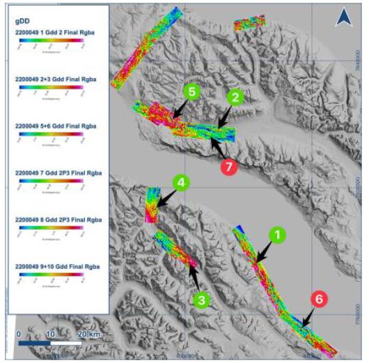
Sources: KoBold, 2023
Notes: Green circles: Plausibles Targets and Red circles: Weak anomalies
Figure 7-11 display the results of the gravimetric survey carried out in the Qullissat area are presented; these identify a tube-shaped intrusion interpreted as a mafic body extending from the outcrop to a depth of 1,150 m, in comparison with previous electromagnetic surveys, which would suggest a strong electromagnetic response. KoBold highlighted this correlation and supports it with surface geochemical indicators.
| SRK EXPLORATION LIMITED ■ JUNE 2026 | 102 |
| Technical Report Summary for the Disko-Nuussuaq Project |
| EXPLORATION |
Figure 7-11: Gravity and Electromagnetic survey in Qullissat at surface
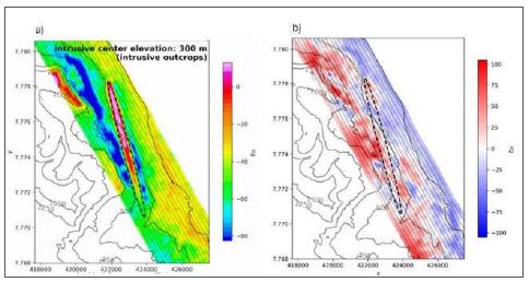
Sources: KoBold, 2023
Notes: a) Falcon Predicted Gzz response (Eo); b) Residual Gzz response (Eo)
HeliSAM and SAMSON EM Surveys
During the programme, Nikkeli switched its focus from HeliSAM to SAMSON to ensure sufficient depth penetration for the targets of interest. As SAMSON is a ground-based technique, it has a lower data acquisition rate compared with HeliSAM. Consequently, the planned electromagnetic surveys of Hammers Dal and the Kuugannguaq Valley were not carried out, although it is noted that these are scheduled to be conducted during future field campaigns. The following findings stood out from this study (Figure 7-12):
| § | An EM anomaly has been identified within the Qullissat intrusion, on the north coast of Disko Island. Simulated response models suggest that the conductive body lies at a shallow depth (110 m ± 100 m), measures approximately 600 x 900 m and is about 25 m thick. It is noted that this working model coincides with the modelled depth of an electromagnetic anomaly identified in a GeoTEM aerial survey carried out in 1992. |
| § | Broad, smooth mid-time (channels 15-20 in HeliSAM) EM anomaly has been identified in the Aaffarsuaq Valley on the Nuussuaq Peninsula. Modelling of this anomaly indicates a deep (c. 800m to the centre and c. 400m to the top) and weakly conductive body. |
| § | A significant anomaly is found along the strike of the 28-tonne high-grade massive sulphide body at Igdlukunguaq. |
| SRK EXPLORATION LIMITED ■ JUNE 2026 | 103 |
| Technical Report Summary for the Disko-Nuussuaq Project |
| EXPLORATION |
Figure 7-12: Identified EM anomalies
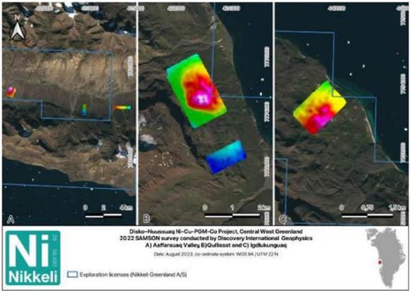
Sources: Bluejay, 2023
| 7.2.3 | SRK Comment |
SRK EX note that the 2019 reprocessing of electromagnetic resistivity data often gives variable results. In contrast, the IP data are more reliable, and the UBC inversion performs well; however, the use of two different resistivity base levels has led to a reduction in IP amplitudes, with inversions yielding differing peak responses (14 mV/V versus 20 mV/V) despite delineating the same anomaly. The chargeability sections indicate a non-anomalous upper layer approximately 250 m thick, which does not correlate well with the upper portion of the gravity anomaly (not yet fully assessed). Overall, the IP chargeability anomaly remains the most reliable geophysical technique, but its apparent continuity along a horizon of generally low IP response suggests the possibility of a chargeable horizon within the sedimentary sequence rather than a discrete, localized body.
The 2022 Sub-Audio Magnetic survey grids located near the coastline was significantly affected by strong telluric currents in the sea, driven by solar-induced perturbations. These produced enhanced long-wavelength diurnal magnetic variations that compromised the SAM records. The contractor subsequently applied advanced filtering to remove much of this diurnal noise, which improved the appearance of the magnetic maps. Despite these corrections, the SAM results are assessed as less reliable than the Falcon magnetic data, and are not considered a primary dataset for interpretation.
| SRK EXPLORATION LIMITED ■ JUNE 2026 | 104 |
| Technical Report Summary for the Disko-Nuussuaq Project |
| EXPLORATION |
| 7.3 | Surface Geochemistry |
| 7.3.1 | Bluejay Mining (2017) |
In late 2017, Bluejay collected a small number of samples from the area of the Igdlukunguaq dyke for petrophysical, petrographic, and geochemical analysis by ALS in Ireland; the results confirmed the existence of an active sulphide system, and initial analyses of the highly oxidised surface material yielded 2.02% nickel, 0.8% copper, and 0.2% cobalt. Furthermore, sample (Figure 7-13 was prepared using a method known as ‘polished thick section’ indicates the presence of features suggestive of large-scale segregation of nickel, copper, cobalt, and PGEs.
Figure 7-13: Sample of massive sulphide from the area of the Igdlukunguaq dyke
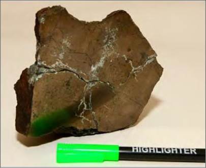
Sources: 80 Mile, 2025
| 7.3.2 | Bluejay Mining (2019) |
The geochemical exploration methodology developed by Bluejay Mining plc at the Disko– Nuussuaq project represents a modern approach aimed at detecting deep, non-outcropping mineralisation, particularly in combination with other disciplines such as geology and geophysics. Unlike historical campaigns, which focused on direct lithogeochemical sampling of rocks, the strategy implemented by the company focuses on the use of advanced geochemical techniques capable of identifying subtle geochemical signatures associated with deposits potentially hidden beneath significant thicknesses of cover.
The geochemical exploration work carried out by Bluejay is described in Table 7-3.
| SRK EXPLORATION LIMITED ■ JUNE 2026 | 105 |
| Technical Report Summary for the Disko-Nuussuaq Project |
| EXPLORATION |
| Table 7-3: Bluejay Surface Exploration, 2019 | ||||||||||||
| Licence | Location | Type of | Methodology | Sampling | Key Results | Geological | ||||||
| Geochemical | Characteristics | Interpretation | ||||||||||
| Work | ||||||||||||
| MEL 2012-29 | Disko Island – Nuussuaq Peninsula | Systematic soil geochemistry (pilot programme) | MMI-ME™ and SGH™ techniques | 1,126 sample pits along 22 lines; 50–100 m spacing; 10–30 cm depth; duplicates and QA/QC applied | Multiple Ni and Cu anomalies detected; strong coincidence with geophysical targets; effective under variable overburden | Indicates concealed Ni–Cu sulphide mineralisation at depth; strong correlation with EM/ZTEM anomalies; supports defined drill targets in Aaffarsuaq and Kuugannguaq valleys. | ||||||
| MEL 2017-01 | Igdlukunguaq area (Disko Island) | Soil geochemistry and limited rock geochemistry | MMI-ME™ and SGH™ + ICP analysis of rock samples | Soil sampling consistent with regional grid; additional sampling of outcrops and boulders | Soil anomalies present; rock assays show low Ni–Cu grades; sulphidic outcrops identified | Suggests buried sulphide mineralisation not evident at surface; anomalies likely tied to deeper systems; further geophysics and drilling required. | ||||||
| MEL 2018-16 | Disko Island (Qullissat area and surroundings) | Soil geochemistry and rock geochemistry | MMI-ME™ and SGH™ + ICP rock analysis + physical property measurements | Systematic soil grid (50–100 m spacing); additional mapping and sampling of mineralised zones | Sulphidic zones identified (Delta, Ujarassuit); Ni–Cu anomalies confirmed; linked to magnetic anomalies | Indicates mineralised mafic intrusions with disseminated sulphides; supports conduit-hosted sulphide model and geophysical targets. | ||||||
| MEL 2019-116 | Disko Island – Nuussuaq Peninsula | Reconnaissance (no geochemical programme) | No systematic geochemistry was conducted | Field visits only; no sampling data | No geochemical results available | Early-stage licence; no interpretation possible; requires future geochemical surveys. | ||||||
Sources: Bluejay Geological Report for the 2019 season
Bluejay’s 2019 field programme consisted mainly of systematic geochemical soil sampling in areas selected based on previous desk studies (Figure 7-14). At each sampling point, a pit measuring approximately 30 × 30 cm was excavated to a depth of between 10 and 30 cm, from which a representative soil sample of around 300 g was extracted. To increase the reliability of the analytical results, two subsamples were taken per point to be analysed using different techniques, and a small sample was additionally collected for pH determination.
| SRK EXPLORATION LIMITED ■ JUNE 2026 | 106 |
| Technical Report Summary for the Disko-Nuussuaq Project |
| EXPLORATION |
Figure 7-14: Soil sampling locations
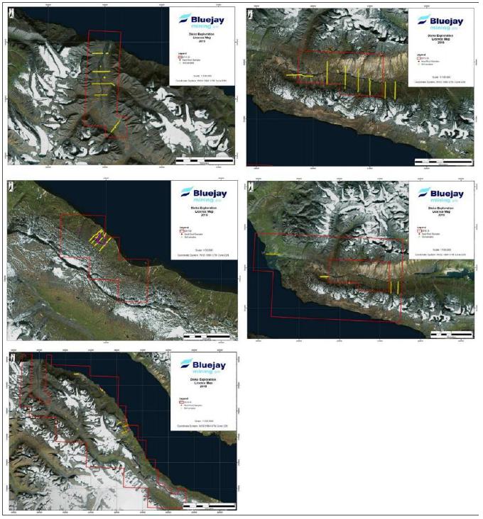
Sources: Bluejay Geological Report 2019
Notes: These images are available in the 2019 Bluejay field technical report
According to the company, preliminary results indicated that both methodologies (MMI-METM and SGHTM + ICP) are effective at detecting geochemical signals in areas with thin cover as well as those with significant overburden, representing a significant step forward for the exploration of deep targets in the project area (Figure 7-15 to Figure 7-18).
| SRK EXPLORATION LIMITED ■ JUNE 2026 | 107 |
| Technical Report Summary for the Disko-Nuussuaq Project |
| EXPLORATION |
Figure 7-15: MMI soil geochemistry results (response ratios for nickel at Qullissat
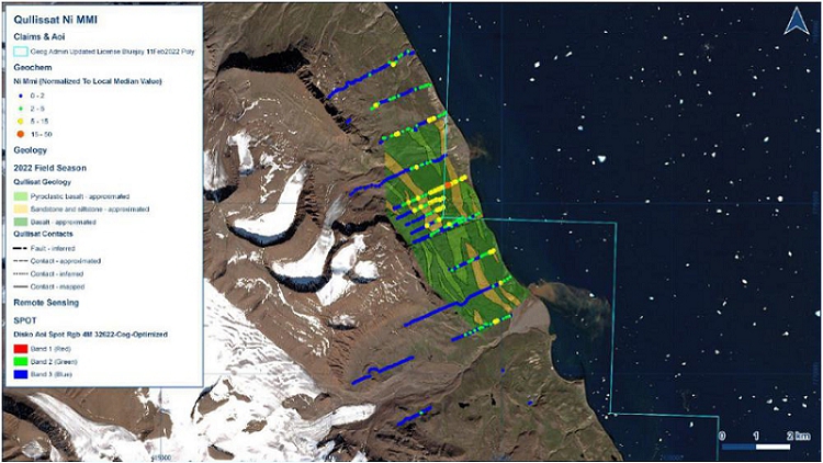
Sources: KoBold. 2023
| SRK EXPLORATION LIMITED ■ JUNE 2026 | 108 |
| Technical Report Summary for the Disko-Nuussuaq Project |
| EXPLORATION |
Figure 7-16: MMI soil geochemistry results (response ratios for nickel at Igdlukunguaq
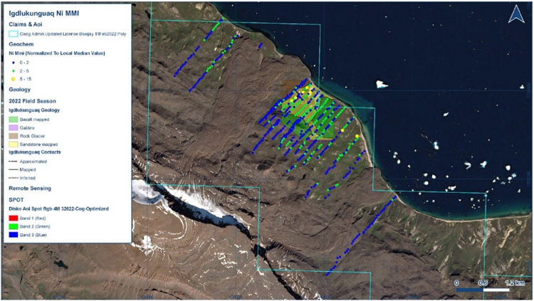
Sources: KoBold. 2023
| SRK EXPLORATION LIMITED ■ JUNE 2026 | 109 |
| Technical Report Summary for the Disko-Nuussuaq Project |
| EXPLORATION |
Figure 7-17: MMI soil geochemistry results (response ratios for nickel at Affaarsuaq
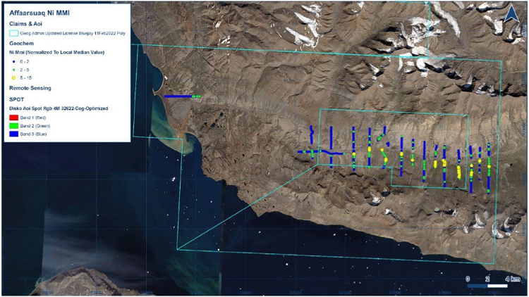
Sources: KoBold. 2023
| SRK EXPLORATION LIMITED ■ JUNE 2026 | 110 |
| Technical Report Summary for the Disko-Nuussuaq Project |
| EXPLORATION |
Figure 7-18: MMI soil geochemistry results (response ratios for nickel at Kuug Valley
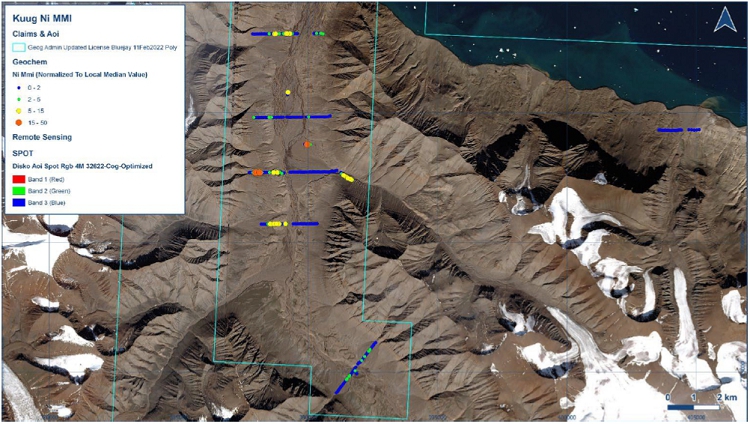
Sources: KoBold. 2023
| SRK EXPLORATION LIMITED ■ JUNE 2026 | 111 |
| Technical Report Summary for the Disko-Nuussuaq Project |
| EXPLORATION |
SRK EX Comment
SRK EX considers that the methodology applied by Bluejay aids in interpreting the potential for deep mineralisation and detecting surface anomalies of mobile pathfinders. Samples were taken as close as possible to predetermined sampling locations and their position recorded using GPS. Should the predetermined sampling sites not be accessible based on the local ground conditions, Bluejay’s protocol allowed for the sampling point to be moved up to 10 m in any direction. SRK EX recommends the following improvements could be applied in future surface geochemistry programmes:
| § | Incorporate multi-horizon sampling: Sampling was carried out at depths of between 10 and 30 cm, and the type of soil horizon from which the sample was taken was not recorded. In a glacial environment it is important to record the geological and soil context of the sample, since geochemical dispersion can be extreme; |
| § | Increase the spatial resolution of the sampling: The spacing between samples was between 50 and 100 m. Tighter spacing could improve the definition of an anomaly, and assist with determining a potential deposit’s geometry and continuity; |
| § | Expand the analytical spectrum: The methods used can only detect indirect mineralisation signals through geochemical proxies. It would be beneficial to broaden the analytical suite using methods such as ICP-MS multi-element analysis, specific PGE (Pt, Pd, Rh) analysis, and isotope analysis (S, Pb) in key areas; |
| § | Characterisation of the geochemical background: The methodology should define local background values by lithology to distinguish genuine anomalies and reduce ambiguity among samples; |
| § | Adaptation to the glacial environment: The methodology should correlate the geochemistry of the samples with studies of glacial transport, to determine the direction of dispersion of anomalies. |
| 7.3.3 | KoBold Metals (2022) |
The geochemical exploration campaign carried out in 2022 at the Disko–Nuussuaq project represents one of the most extensive and advanced programmes undertaken to date in the area. The main objective of this work was to validate and refine the geophysical targets previously identified by obtaining independent geochemical evidence and to increase confidence in the existing exploration models.
The geochemical programme involved a comprehensive approach based on three main types of sampling: soil, stream sediments, and rocks:
| § | Soil Samples: systematic sampling was carried out at 1,437 points distributed across 45 profiles in the key areas of Qullissat (Figure 7-19), the Aaffarsuaq valley, and Igdlukunguaq. Sampling points were typically spaced at intervals of approximately 50 m along profiles ranging from 150 m to 2 km in length, depending on the area and specific objective. At each site, two subsamples were collected: one for analysis using the Mobile Metal Ions (“MMI”) technique, aimed at detecting the mobile fraction of metals, and another for multi-element analysis via total acid digestion (four-acid digest) and determination by ICP-MS. This dual approach allowed for a direct comparison of mobile geochemical signals with total element concentrations, thereby enhancing the robustness of the interpretation; |
| SRK EXPLORATION LIMITED ■ JUNE 2026 | 112 |
| Technical Report Summary for the Disko-Nuussuaq Project |
| EXPLORATION |
| § | Stream Sediment Samples: 337 samples were collected, distributed throughout the licence area, with the highest density in the Kuugannguaq and Aaffarsuaq valleys. At each point, two types of sample were obtained: a fine fraction (<0.2 mm) and a heavy mineral concentrate (“HMC”), which allowed for the assessment of both regional geochemical dispersion and the presence of indicator minerals in the drainage systems. |
| § | Rock Samples: 347 samples were collected, primarily for lithogeochemical purposes and the characterisation of intrusions, as well as the analysis of mineralised samples in specific areas. |
Figure 7-19: Spatial Distribution of Ni concentrations in MMI samples at Qullissat
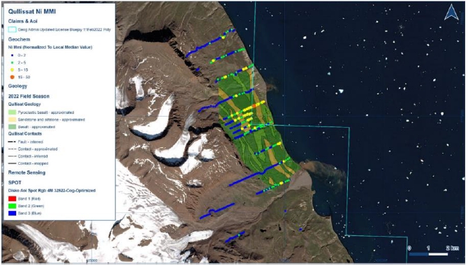
Sources: KoBold Metals Report 2022
Table 7-4 shows the geochemical interpretation for each exploration sector, based on the analytical results:
Table 7-4: KoBold interpretation of rock and soil geochemistry
| Sector | Geochemical Results | Supporting
Evidence |
Geological Interpretation |
Qullissat intrusion (Disko Island, north coast) |
Consistent multi-element soil anomalies (Ni, Cu, Co, Pt, Pd, Au, Se, Te, Cr); strong agreement between MMI and four-acid digest |
Soil and rock geochemistry: evidence of sulphur saturation in the intrusion | High-priority target; indicates a mafic intrusion that reached sulphide saturation, a key process for magmatic sulphide formation; strong potential for Ni–Cu–PGE mineralisation at depth. |
| SRK EXPLORATION LIMITED ■ JUNE 2026 | 113 |
| Technical Report Summary for the Disko-Nuussuaq Project |
| EXPLORATION |
| Aaffarsuaq Valley (Nuussuaq Peninsula) | Broad and coherent multi-element anomalies in soil geochemistry; significant Ni, Cu and PGE signatures |
Spatial correlation with large EM conductors and gravity anomalies | Suggests the presence of a large, deep-seated mafic-ultramafic intrusion hosting possible magmatic sulphide mineralisation; represents a major drill target. |
| Igdlukunguaq Target Area (Disko Island, NE Coast) | Weak or absent soil geochemical anomalies despite known high-grade sulphide boulder | Lack of anomalism in soils around the boulder; geophysical anomalies located upslope | Indicates that the massive sulphide boulder is transported and not in situ; potential source likely located upslope associated with geophysical anomalies or has moved to the area as part of a rock slide from above. |
| Kuugannguaq Valley (Disko–Nuussuaq Region) | Limited direct soil anomalies; some anomalous Ni in stream sediments but no consistent Ni–Cu association | Stream sediment geochemistry; partial geophysical coverage | Low potential for surface or near-surface mineralisation; supports interpretation that targets are deep and blind rather than outcropping. |
Sources: Bluejay: Results of 2022 Field Programme at Disko-Nuussuaq
SRK EX considers that the comparison between the methodologies used for soil samples (MMI and four-acid digestion) should be interpreted for each sample through statistical validation of the methods. Provided that the validation is error-free, it is possible to correlate the data from a geochemical perspective. Additionally, SRK EX recommends the following to increase the level of confidence in the selection of drilling targets:
| § | Expand the geochemical analysis package to cover the geochemical characteristics of the entire mineral system; to this end, elements such as IPGE (Ir, Os, Ru) should be included along with sulphide characterisation; |
| § | Characterisation of the geochemical background; and |
| § | Determining the geometry and continuity of the anomalies by reducing the sampling interval. |
In 2022, KoBold undertook rock chip and grab sampling of outcrop and transported boulders alongside geological mapping. CRM samples were inserted at regular intervals of 20 samples to monitor QA/QC performance. A total of 350 samples were collected across five separate areas shown in Figure 7-20. The highest grade recorded was 5.78% Ni in a sample taken from a transported boulder containing massive sulphides near the contact of the Igdlukunguaq Dyke.
| SRK EXPLORATION LIMITED ■ JUNE 2026 | 114 |
| Technical Report Summary for the Disko-Nuussuaq Project |
| EXPLORATION |
Figure 7-20: Ni results from grab sampling in 2022
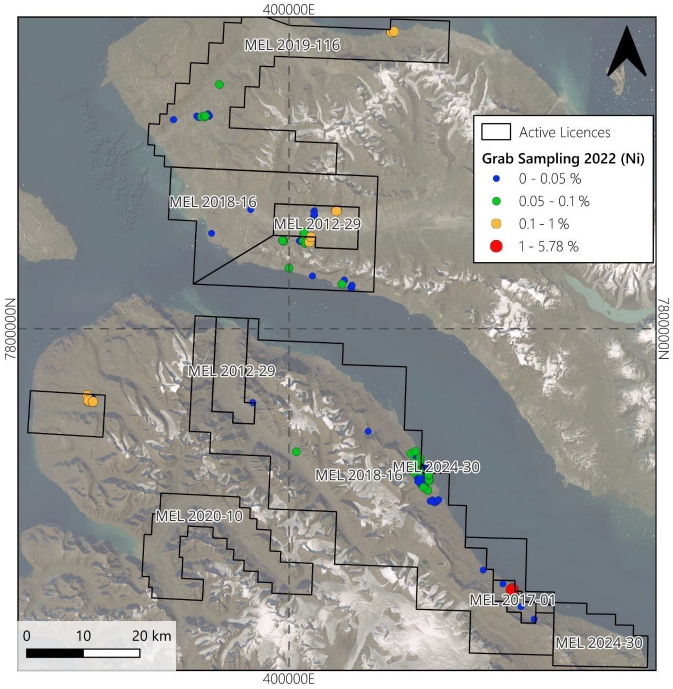
Sources: SRK EX, 2026. Data received from 80 Mile.
| 7.4 | SRK Comments |
The Serfat area confirms a well-defined intrusive complex, however the Ni-Cu depletion in the quartz dolerite suggests a major sulphide accumulation was not intersected. The carbonaceous sediments however are sulphur bearing acting as a sufficient source for a Ni-sulphide system.
At the Itilli valley some of the sills of the Vaigat formation show signs of Ni-Cu depletion indicating sulphide segregation occurred elsewhere in the system.
| SRK EXPLORATION LIMITED ■ JUNE 2026 | 115 |
| Technical Report Summary for the Disko-Nuussuaq Project |
| EXPLORATION |
In the Sarqaq Valley, EM anomalies are confirmed to be caused by conductive saltmarsh and carbonaceous sediments, rather than a mineralised sulphide accumulation.
While the majority of geophysical targets were tested, Falconbridge encountered multiple drilling difficulties leading to fewer metres being drilled than planned. In 1993, poorly lithified sediments at Igdlukunguaq prevented holes from reaching their planned depth. In 1994, the problems are Serfat were related to the thick accumulations of coarse overburden. In the Itilli Valley, permafrost, gas and buried ice acted as obstacles causing delays. At Qullissat, fluid loss in the hole was the major problem. In the Sarqaq Valley, non-lithified sediments and cavities resulted in collapsing drillhole walls and shearing of rods due to whipping in cavities.
The gold concentrations intersected in Falconbridge’s drilling was analysed from the magnetic fraction and therefore the actual gold present in that sample would be considerably lower.
Attempts at drilling in the areas were largely performed using procedures common to the industry at the time of drilling. Drillhole parameters for all historic drilling can be found in Appendix C. Taking advantage of the advancements on drill rig design and operation, SRK EX propose that many of the past drilling problems, including drilling bad ground and pressurised systems, may be avoidable in the upcoming drill programme.
Various collar locations have been proposed, initially in 2021, and later in 2026 for exploration scout drilling. The drill collar locations proposed for 2026 in the Qullissat area are identical to collars planned in 2022. It is evident that the geophysical targeting conducted by KoBold in 2022 and 2023 has not changed 80 Mile’s targeting and the original interpretation remains to be tested.
| SRK EXPLORATION LIMITED ■ JUNE 2026 | 116 |
| Technical Report Summary for the Disko-Nuussuaq Project |
| SAMPLE PREPARATION, ANALYSES AND SECURITY |
| 8 | SAMPLE PREPARATION, ANALYSES AND SECURITY |
This section details the preparation, analysis and security of the samples for 80 Mile’s grab, soil and stream sediment sampling programmes from 2017 onwards. Details on sampling prior to 2017 is summarised in AMEC Foster Wheeler, 2015.
| 8.1 | Sample Preparation and Analyses |
| 8.1.1 | 2019 Programme |
Soil Sampling
Two identical samples were taken from each sample location; one for Mobile Metal Ion (MMI-METM) analysis by the SGS laboratory in Vancouver, Canada, and one for Spatiotemporal Geochemical Hydrocarbon (SGHTM) analysis by the Actlabs laboratory in Ontario, Canada. Additionally, one smaller sample was taken for pH determination.
The company’s report mentions that the sampling point for some samples was altered and shifted by several tens of metres from the original location.
The samples were collected using a shovel and double-bagged in 1-litre zip-lock bags. The typical sample size was between 250 and 300 g. The sample pits were approximately 30 to 40 cm in diameter and 20 to 30 cm deep, usually 10 to 20 cm below the organic layer, or shallower if an organic layer was not present. To avoid sample contamination, technicians refrained from wearing jewellery and used unpainted tools that were cleaned after every use.
SRK EX understands the methodology behind both methods applied to the soil samples but has no information on the procedure for collecting three identical samples at the same sampling point, the representativeness of each sample under each method, or the vertical and horizontal distances between them.
Furthermore, SRK EX is aware that the original locations of each sampling point may have been altered in the field for logistical reasons, but it has not been confirmed that these locations are suitable for meeting the objectives set for the original locations. In this regard, no information is available on the depth or type of soil horizon from which the samples were taken.
Grab Sampling
The grab sampling method used in this project involved the selective collection of individual rock samples during geological mapping and prospecting work (boulder hunting). This type of sampling was mainly applied in licences MEL 2017-01 and MEL 2018-16, where outcrops, boulders, and areas with visual evidence of mineralisation (e.g., presence of sulphides, oxidation or alteration) were identified.
The samples were collected manually at the surface, prioritising materials representative of the observed geological features, although not necessarily representative of the total volume of the lithological unit. In some cases, erratic boulders associated with rock flows/slides or areas of glacial transport were also collected. Sample locations were documented using GPS and photographic records to provide a geological context for each sample.
| SRK EXPLORATION LIMITED ■ JUNE 2026 | 117 |
| Technical Report Summary for the Disko-Nuussuaq Project |
| SAMPLE PREPARATION, ANALYSES AND SECURITY |
After collection, the rock samples were sent for geochemical analysis to in ALS Finland/Ireland by ICP-AES, along with measurements of physical properties such as specific gravity, magnetic susceptibility, and conductivity.
SRK EX understands that the sampling points were selected through a literature review in the areas most likely to contain mineralisation, and that the rock sample is representative of each outcrop. In this regard, collecting samples of erratic boulders would not provide accurate information on their origin and would not be representative, given the strong influence of mechanical dispersion mechanisms in this type of environment.
Furthermore, SRK EX considers that the size of the rock samples and the sampling method are important in this type of deposit, as the samples must be fairly large (between 2 kg and 5 kg), given that this is primarily related to the heterogeneity of the sulphides and the ‘nugget effect’ of the platinum group elements (PGEs); however, the report makes no mention whatsoever of the size of the samples collected.
| 8.1.2 | 2022 Programme |
Soil Sampling
Soil sampling was carried out at sites that had been previously defined and uploaded to digital devices to ensure their accurate location in the field. Where it was not possible to take samples at the exact location (for example, due to terrain conditions or permafrost), the sampling point was relocated to a suitable nearby area, and the new coordinates were recorded.
Protocols dictated that, where possible, samples should be collected from soil horizon C, immediately below the surface soil cover, to minimise the effects of surface contamination and obtain a geochemical signal representative of the substrate.
Two identical samples were taken from each sample location: a sample that was sent for four-acid digest with ICP finish at an ALS laboratory, and a second sample for MMI analysis at an SGS laboratory. The samples were collected with an auger and a paint-free garden trowel (Figure 8-1), with a preferred sample weight of 400 g. The minimum line spacing was 150 m and maximum 2 km. The sample spacing along the line was generally 50 m.
| SRK EXPLORATION LIMITED ■ JUNE 2026 | 118 |
| Technical Report Summary for the Disko-Nuussuaq Project |
| SAMPLE PREPARATION, ANALYSES AND SECURITY |
Figure 8-1: Soil sampling procedure
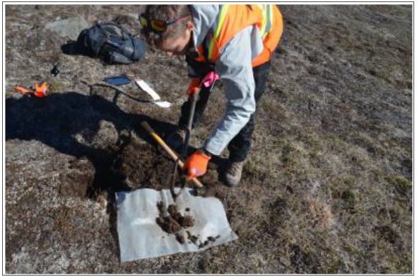
Sources: MLSA Report_2022
SRK EX understands that priority has been given to the collection of samples from Horizon C and to the various methodologies applied to them. The report on this programme, together with the standard operating procedures (SOP) document, makes no mention of:
| § | the procedure for separating samples at each sampling point with a view to applying different analytical methodologies; |
| § | purpose of the selected spacing between samples and lines, and its specifications; |
| § | the definition of sampling lines in relation to the direction of glacial transport; |
| § | the thickness of till deposits; |
| § | soil moisture conditions; |
| § | the presence of variations in the soil’s stratigraphic profile in relation to the horizons and the soil itself, as this varies at each sampling point; and |
| § | parameters relating to the concentration of clayey material. |
Stream Sediment Sampling
The objective of stream sediment sampling was to characterise the geochemistry of active drainage basins. Sampling sites were selected at locations conducive to sediment accumulation, such as boulder traps, pools or channel margins where fine-grained materials tend to settle.
Two samples were collected from each sampling site: one sample of panned heavy mineral concentrate (“HMC”) with a minimum weight of 150 g, and one sample of the finer clay fraction with a minimum weight of 100 g. Sampling spots varied from one to several, depending on the available sediment in the stream. In locations with sparse material, additional sampling would be carried out upstream from the first subsample and used to create a composite sample.
| SRK EXPLORATION LIMITED ■ JUNE 2026 | 119 |
| Technical Report Summary for the Disko-Nuussuaq Project |
| SAMPLE PREPARATION, ANALYSES AND SECURITY |
The sampled material was sieved through an 8-mesh sieve (2.5 mm aperture) and subsequently a 70-mesh sieve (0.2 mm aperture). The middle fraction (0.2 to 2.5 mm) was panned to an HMC fraction, and the fine fraction (<0.2 mm) was kept as a separate sample (Figure 8-2).Grab Sampling
Figure 8-2: Stream sediment sampling procedures
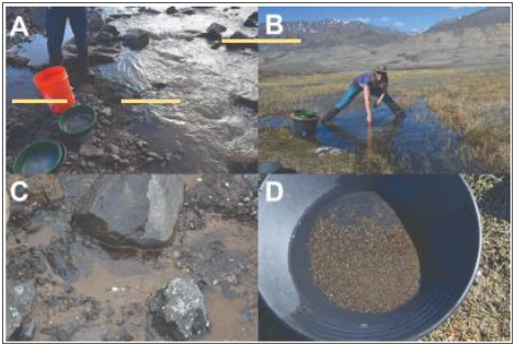
Sources: MLSA Report_2022
Notes: (A) Equipment used. (B) Sampling of the stream with a small shovel. (C) Stream sediment sample location here is a boulder trap. (D) Heavy mineral concentrate
SRK EX considers that the application of this type of sampling at very early stages of exploration should be carried out in accordance with the following considerations:
| § | To identify mineralised source areas upstream. |
| § | Identify glacial or fluvial transport patterns. |
| § | Identify erosion-resistant indicator minerals. |
| § | Prioritise areas for detailed prospecting. |
Grab Sampling
Rock samples collected during the field programme were submitted to a commercial analytical laboratory (ALS, Canada) for preparation and geochemical analysis following standard industry procedures. Rock samples collected during the fieldwork were mainly in situ rocks collected as grab samples; however, some rocks were transported boulders, e.g., rocks collected from quaternary-filled valley floors, likely representing glacially transported rocks.
Upon arrival at the laboratory, samples underwent a multi-stage preparation process. Initially, the samples were crushed using method CRU-31, achieving better than 70% passing 2 mm. A representative subsample was then obtained using a riffle splitter (SPL-21) to ensure homogeneity and reduce sampling bias.
| SRK EXPLORATION LIMITED ■ JUNE 2026 | 120 |
| Technical Report Summary for the Disko-Nuussuaq Project |
| SAMPLE PREPARATION, ANALYSES AND SECURITY |
The selected split was subsequently pulverised (PUL-32) to achieve better than 85% passing 75 microns, providing a fine, homogeneous pulp suitable for geochemical analysis. Prepared pulps were analysed using a combination of analytical techniques tailored to multi-element geochemistry and target commodities. These included:
| § | ME-ICP06: Whole-rock analysis by ICP-AES with loss on ignition; |
| § | ME-MS81: Lithium borate fusion followed by ICP-MS for trace elements; |
| § | ME-MS42: Ultra-trace multi-element analytical method; and |
| § | ME-4ACD81: Four-acid digest for base metals. |
This combination of analytical methods ensured comprehensive elemental coverage, including major, trace, and ultra-trace elements relevant to the exploration targets.
In addition to laboratory analyses, selected rock samples were analysed in the field using a portable X-ray fluorescence (“pXRF”) analyser (Olympus Vanta C) to obtain preliminary geochemical data. The instrument was calibrated at the beginning of each session, and quality control checks were performed regularly using standards and blanks to monitor analytical performance. This type of analysis is unlikely to be representative but is useful for high-level indications of lithogeochemistry and mineralisation.
The laboratory implemented internal QA/QC procedures, including the use of blanks, standards, and duplicates, to ensure analytical accuracy and precision.
SRK EX understands the various analytical methodologies applied to rock samples at this stage of exploration, but considers that important information regarding this technique is not provided in detail; the gaps are described below:
| § | The standardised sampling procedure and the considerations regarding the selection of the location of each sampling point are not specified. |
| § | The size of the sample collected in the field is not specified. |
| § | It is not specified whether the various analytical methods are applied to all samples or only to selected ones. |
| § | There is no mention of the procedure for separating the original sample for each of the methodologies used. |
| § | There is no mention of the criteria for selecting rock samples for analysis by pXRF, or whether this is determined by the laboratory or by a company representative. |
| § | Monitoring of the laboratory’s internal QA/QC controls. |
| SRK EXPLORATION LIMITED ■ JUNE 2026 | 121 |
| Technical Report Summary for the Disko-Nuussuaq Project |
| SAMPLE PREPARATION, ANALYSES AND SECURITY |
| 8.2 | Sample Security and Chain of Custody |
| 8.2.1 | 2019 Programme |
Geochemical Sampling
According to the report by the company, the samples were immediately placed in plastic bags, using double bagging to minimise the risk of loss or contamination. Each sample was carefully labelled and linked to GPS coordinates previously defined or adjusted in the field, ensuring accurate spatial traceability from the sampling point to the laboratory.
To preserve the quality of the samples, strict contamination control measures were implemented during sampling, such as cleaning tools between sampling points, using appropriate equipment, and handling materials with care.
The samples were transported from the sampling sites to base camp by helicopter or boat and were subsequently sent to accredited, independent laboratories: SGS (Vancouver) and Actlabs (Canada).
SRK EX has no information regarding the formal chain-of-custody documentation, nor any details on the risk and contamination prevention procedures carried out during the collection of the original sample, its separation for the application of different methodologies, or between sampling points. Furthermore, there is no mention of the risks involved in the transport of the samples or how controls were carried out at this stage.
| 8.2.2 | 2022 Programme |
Geochemical Sampling
In the field, all rock (grab), soil, and stream sediment samples were labelled immediately after collection, using unique identifiers linked to digital records and manual backups. The recorded information included UTM coordinates, date, sample type, and relevant geological descriptions, stored both on electronic devices and in field notebooks as a redundant check.
The samples were placed in sturdy bags, sealed, and stored under controlled conditions throughout the campaign. Access to the samples was restricted to authorised members of the geological team, thereby minimising the risk of tampering or contamination.
During fieldwork, location data and metadata were recorded in digital applications (e.g., QField) and backed up by manual records, enabling continuous monitoring of the traceability of each sample.
Once the fieldwork was complete, the samples were grouped, inventoried, and prepared for transport to certified commercial laboratories (such as ALS and SGS).
The available documentation does not include formal chain-of-custody records, preventing SRK EX from independently assessing the security of samples from collection through laboratory submission. Information regarding contamination prevention protocols during sample collection, subsampling, and handling between sampling sites was not available. Similarly, no details were provided on sample transport procedures, potential risks affecting sample integrity, or the measures implemented to mitigate such risks during transit.
| SRK EXPLORATION LIMITED ■ JUNE 2026 | 122 |
| Technical Report Summary for the Disko-Nuussuaq Project |
| SAMPLE PREPARATION, ANALYSES AND SECURITY |
| 8.3 | Specific Gravity Measurement |
Not applicable to these sampling programmes. Specific gravity was measured solely in the context of characterising rock samples, as a supplementary parameter for geological and mineralogical interpretation.
| 8.4 | Quality Assurance and Quality Control Procedures |
Quality assurance “QA” is primarily a planning exercise, the process of setting up a system with protocols so that the data collected are of a sufficient standard for the purpose to which they will be used for. It consists of Standard Operating Procedures “SOPs” that are deemed fit for purpose that are used to govern how the data or sample are collected. It also consists of training, so that the people employed have the knowledge and skills to collect these data according to the standard of the SOP.
Quality control “QC” is the active practice of monitoring the sample or data collection practice while the programme is ongoing, so that the data can be continuously monitored, and corrected if the system is observed to be “out of control”. This allows poor data to be handled and fixed in real time as far as can be practical.
| 8.4.1 | Quality Assurance Procedures & Protocols |
Geochemical Sampling 2019
A systematic QA/QC programme was implemented for the geochemical sampling campaign, including the insertion of duplicate samples and CRMs, as well as strict field protocols to minimise contamination and maintain sample integrity (Table 8-1). Analytical work was conducted by independent, internationally recognised laboratories employing internal QA/QC procedures. The insertion frequency of CRMs and duplicate was not explicitly reported.
Table 8-1: QA/QC Procedures
| QA/QC
Procedure |
Description | Sample
Type |
Purpose | SRK EX Comments |
| Field duplicates | Two identical samples were collected. | Soil | Assess sampling precision and reproducibility and comparison of analytical methods | There is no information on the frequency and procedure for splitting samples in the field. |
| Certified Reference Materials | Systematic insertion of CRMs | Soil | Control analytical accuracy and laboratory performance | There is no information on the frequency and type of CRM material used. |
| SRK EXPLORATION LIMITED ■ JUNE 2026 | 123 |
| Technical Report Summary for the Disko-Nuussuaq Project |
| SAMPLE PREPARATION, ANALYSES AND SECURITY |
| pH sub-samples | An additional small sample was taken at each location for pH measurement | Soil | Characterise geochemical conditions affecting element mobility | There is no information on the sample collection procedure or the size of the sample. |
| Tool cleaning between samples | Cleaning of sampling equipment after each collection | Soil | Prevent cross-contamination | There is no procedure for this. |
| Use of non-contaminating tools | Use of unpainted shovels and appropriate equipment | Soil | Minimise introduction of external contaminants | There is no procedure for this. |
| Personal contamination control | Avoidance of jewellery and metallic objects during sampling | Soil | Reduce contamination risk | No comments. |
| GPS location recording | Recording of actual sampling coordinates in the field | Soil and rock | Ensure traceability and spatial accuracy | In some cases, the locations were changed for logistical reasons |
| Laboratory QA/QC procedures | Internal quality controls (e.g., detection limits, blanks, calibration) | Soil and rock | Ensure analytical accuracy and precision | SRK EX is unable to comment on these internal protocols. |
Sources: Buejay Geological report 2019
Geochemical Sampling 2022
Quality Assurance and Quality Control (QA/QC) programme was implemented for the 2022 exploration campaign to ensure the reliability, accuracy, and precision of the approximately 1830 samples (Table 8-2).
| Table 8-2: | Geochemical Sampling 2022 QA/QC Procedures |
| QA/QC Sample Type |
Purpose | Sample Type | Protocol / Insertion Rate |
SRK EX Comments |
| CRMs | To monitor the accuracy and analytical bias of laboratory results | Soil, rock, and stream sediments | Inserted at a rate of 1 in 20 samples | The type of CRM is not specified for each sample type (soil, rock and stream) |
| Field Duplicates | To assess sampling precision and natural variability | Soil and stream sediments | Collected at a rate of 1 in 20 samples | There is no information on a standardised procedure for collecting this sample |
| Paired Samples (ALS vs MMI) | To compare analytical methods and reproducibility across different analytical techniques | Soil | Key elements | Comparisons between different methodologies and different laboratories are not recommended. |
| SRK EXPLORATION LIMITED ■ JUNE 2026 | 124 |
| Technical Report Summary for the Disko-Nuussuaq Project |
| SAMPLE PREPARATION, ANALYSES AND SECURITY |
| Paired Samples (HMC + Fine Fraction) | To characterise different geochemical fractions within the same drainage system | Stream Sediments | Key elements | There is no information regarding the purpose of this comparison |
Sources: MLSA Report_2022
| 8.4.2 | Certified Reference Materials |
Certified Reference Materials (CRMs) are incorporated into the geochemical sampling programme as part of a QA/QC protocol to test for analytical precision at the laboratory.
2019 Programme
The report on the work carried out in 2019 mentions the systematic inclusion of CRMs; however, the exact insertion frequency is not specified. The information provided confirms that CRMs were routinely introduced into the sample stream as a quality control measure, although the report does not contain a detailed description of how they were managed or subsequently analysed.
SRK has not seen the results of these data, nor independently assessed this data.
2022 Programme
CRMs were introduced into the sample stream at a nominal ratio of one CRM for every 20 routine samples, for a total of 90 CRMs in a sample set of 1834 approximately. According to the company’s report, the CRMs used were commercially prepared standards with certified concentrations covering a range of elements relevant to the exploration objectives. The CRMs used in this programme are listed below:
| § | OREAS 45f (Lateritic Soil Lithogeochem) |
| § | OREAS 46 (Glacial Till) |
| § | OREAS 681 (PLATINUM GROUP ELEMENT ORE) |
SRK EX has no information on the procedure for introducing this material into the various types of samples, and, in some cases, the samples were analysed using OREAS, for which the certificate is not available in the dataset. The Figure 8-3 shows a graphical analysis of the samples and the OREAS 920.
Analytical Monitoring and Validation
According to the reports on this programme, the laboratory’s analytical results were correlated with the certified values for each CRM (OREAS), and graphical analyses were generated.
Graphical analyses consisted of plotting CRM results for each analyte relative to their certified values, allowing rapid identification of deviations or systematic bias (Figure 8-3). Attention was given to whether results fell within acceptable tolerance limits, typically defined as within ±1, ±2, or ±3 standard deviations of the certified values.
| SRK EXPLORATION LIMITED ■ JUNE 2026 | 125 |
| Technical Report Summary for the Disko-Nuussuaq Project |
| SAMPLE PREPARATION, ANALYSES AND SECURITY |
In addition to visual inspection, quantitative measures were calculated to assess CRM performance, including:
| § | Relative standard deviation (“RSD”) for each analyte; |
| § | Bias, defined as the deviation of the measured value from the certified value; and |
| § | Identification of outliers exceeding predefined tolerance thresholds. |
Figure 8-3: Excerpts of CRM plots for Ni and Co
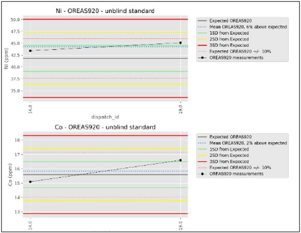
Sources: Bluejay reports, 2022
Notes: Plots corresponding to SD22353906 Lab certificate and OREAS 920
SRK EX understands that the company has carried out an analysis and inspection of the samples, but considers that the procedure was not appropriate, since there are too few data points to meaningfully support an interpretation; more CRM samples should have been inserted for the total sample set. The labelling of these CRMs also suggests that they were not submitted as blinds to the lab, and this is not standard practice for geochemical sampling of this nature.
| 8.4.3 | Blanks |
SRK EX is not aware of any blank quality control samples being used in the geochemical sampling campaigns.
| 8.4.4 | Field Duplicates |
Field duplicates are collected to test the short range, or natural variability in a sample.
| SRK EXPLORATION LIMITED ■ JUNE 2026 | 126 |
| Technical Report Summary for the Disko-Nuussuaq Project |
| SAMPLE PREPARATION, ANALYSES AND SECURITY |
2019 Programme
The Bluejay 2019 report states that systematic duplicate sampling was carried out as part of the QA/QC process. It is stated that these samples were taken at all sampling points, which implies complete coverage of the boreholes in the programme; however, the exact insertion frequency is not specified.
SRK has not seen the results of these data nor has it assessed them independently.
2022 Programme
According to the Bluejay 2022 report, the field duplicates were collected for soil and stream sediment samples at a rate of approximately one sample in every twenty.
SRK EX has no information regarding the procedure for collecting duplicate samples in the field, nor on how this was carried out for each type of sample.
Analytical Monitoring and Validation
According to the reports from this programme, the laboratory’s analytical results were correlated with graphical analyses (Figure 8-4). To evaluate the duplicates, comparative graphs (cross-plots) were generated between pairs of duplicates, including both those collected in the field and the laboratory’s internal duplicates.
The analyses were carried out without distinguishing between the different types of samples, and so are not significantly comparable and this may have led to an error in the interpretations. Furthermore, SRK EX is unable to assess the laboratory’s internal procedure for obtaining duplicates.
Quantitative metrics were also calculated for each analyte in the duplicates, including:
| § | Relative difference; |
| § | Bias; and |
| § | Coefficient of variation. |
| SRK EXPLORATION LIMITED ■ JUNE 2026 | 127 |
| Technical Report Summary for the Disko-Nuussuaq Project |
| SAMPLE PREPARATION, ANALYSES AND SECURITY |
Figure 8-4: Excerpts of duplicate results for Ni and Co
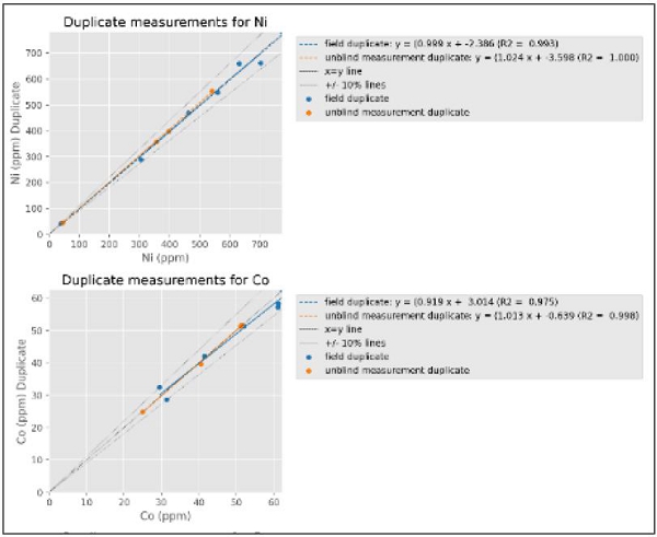
Sources: Bluejay report, 2022
| 8.5 | SRK EX Comments |
The sample preparation, analytical, and safety procedures implemented during the project lack sufficient documentation and consistency across the exploration programmes. Although both the 2019 and 2022 exploration campaigns indicate that QA/QC protocols were implemented, the available information does not describe the specific procedures applied, nor how these protocols were integrated into the different sampling media, including soil, stream sediment, and rock samples. In SRK EX’s opinion, the systematic application, monitoring, and documentation of QA/QC measures are fundamental to ensuring the reliability, accuracy, and representativeness of analytical results, and are therefore critical for the interpretation and evaluation of exploration data.
SRK EX recommends that the following is implemented in future geochemical sampling programmes, as it enhances confidence in the procedures and the analytical results:
| § | Samples must be collected from different soil horizons to assess vertical geochemical variability and the effects of soil-forming processes on the distribution of elements. In accordance with the MMI sampling guidelines, the depth of the samples must exceed 20 cm to ensure representativeness and minimise the influence of surface conditions. When sampling is carried out at several depths, the resulting data can be used to assess the vertical continuity and reproducibility of geochemical anomalies. Although multi-horizon sampling is not mandatory at all sampling points, its systematic application at selected locations is considered good practice for assessing the persistence of anomalies and supporting the interpretation of geochemical results; |
| SRK EXPLORATION LIMITED ■ JUNE 2026 | 128 |
| Technical Report Summary for the Disko-Nuussuaq Project |
| SAMPLE PREPARATION, ANALYSES AND SECURITY |
| § | The absence of reported blank samples represents a key gap in the QA/QC programme. These are important for monitoring potential sample contamination in both field and laboratory procedures; |
| § | While sample tracking and recording procedures are described, the chain of custody documentation is not detailed in terms of formal controls (e.g., sealed shipments, transfer logs). A formal chain of custody form should be implemented for future work; |
| § | The report on the exploration programme carried out in 2022 by Bluejay provides a detailed methodology for quality assurance and quality control but includes only a limited interpretative analysis of the results of these processes at the dataset level. |
| § | Quality control analysis must be carried out using samples of the same type and from the same laboratory; |
| § | The Company should ensure the standardisation of QA/QC protocols across licences and between different exploration campaigns. |
Since these data are only used for the purposes of delineating exploration anomalies and trends, and are not material to a resource estimation, the QP considers data quality is acceptable. SRK EX however notes that however tighter controls and measures should be implemented in the future both in the design of the sampling regime and in the methods an techniques applied to monitor data quality.
| SRK EXPLORATION LIMITED ■ JUNE 2026 | 129 |
| Technical Report Summary for the Disko-Nuussuaq Project |
| DATA VERIFICATION |
| 9 | DATA VERIFICATION |
| 9.1 | Verifications by SRK EX |
| 9.1.1 | Data Verification |
SRK EX has carried out independent analysis of analysed the surface geochemistry data and reprocessed geophysical data in order to assess 80 Mile’s exploration targets in advance of drilling. This is provided in more detail in section 22. The Qualified Person considers this sufficient to support the reporting of exploration results and the confirmation of early stage targets at this stage of exploration.
| 9.1.2 | Site Visit |
The QP has not visited site during the exploration activities reported in this technical report. This report has been independently compiled based on all available reports and data provided by 80 Mile and are available in the public domain.
| 9.1.3 | Independent Verification Sampling |
SRK EX has not carried out any independent sampling within this project. This is not generally applicable to a project at this early stage of exploration, since no defined mineralised zones have yet been found.
| SRK EXPLORATION LIMITED ■ JUNE 2026 | 130 |
| Technical Report Summary for the Disko-Nuussuaq Project |
| MINERAL PROCESSING AND METALLURGICAL TESTING |
| 10 | MINERAL PROCESSING AND METALLURGICAL TESTING |
This section is not currently applicable to the project at its current stage of exploration.
| SRK EXPLORATION LIMITED ■ JUNE 2026 | 131 |
| Technical Report Summary for the Disko-Nuussuaq Project |
| MINERAL RESOURCE ESTIMATES |
| 11 | MINERAL RESOURCE ESTIMATES |
The project tis at an early stage of exploration and there have been no mineral resources defined on the project or licence areas to date.
| SRK EXPLORATION LIMITED ■ JUNE 2026 | 132 |
| Technical Report Summary for the Disko-Nuussuaq Project |
| MINERAL RESERVE ESTIMATES |
| 12 | MINERAL RESERVE ESTIMATES |
There have been no mineral reserve estimates carried out on the project areas to date.
| SRK EXPLORATION LIMITED ■ JUNE 2026 | 133 |
| Technical Report Summary for the Disko-Nuussuaq Project |
| MINING METHODS |
| 13 | MINING METHODS |
This section is not currently applicable to the project since no mineral resource has been defined on the project, therefore it is too early to discuss potential mining methods.
| SRK EXPLORATION LIMITED ■ JUNE 2026 | 134 |
| Technical Report Summary for the Disko-Nuussuaq Project |
| RECOVERY AND PROCESSING METHODS |
| 14 | RECOVERY AND PROCESSING METHODS |
The project is at an early stage of exploration, and no defined mineralised areas have been delineated or estimated. Consequently, no metallurgical test work has been carried out to date in the project area, in line with generally accepted methods in exploration.
| SRK EXPLORATION LIMITED ■ JUNE 2026 | 135 |
| Technical Report Summary for the Disko-Nuussuaq Project |
| PROJECT INFRASTRUCTURE |
| 15 | PROJECT INFRASTRUCTURE |
The project is at an early stage of exploration, and no mineral resource has yet been estimated. As such, no assessment for the development infrastructure requirements has been completed.
| SRK EXPLORATION LIMITED ■ JUNE 2026 | 136 |
| Technical Report Summary for the Disko-Nuussuaq Project |
| MARKET STUDIES AND CONTRACTS |
| 16 | MARKET STUDIES AND CONTRACTS |
Not applicable to the project at this time.
| SRK EXPLORATION LIMITED ■ JUNE 2026 | 137 |
| Technical Report Summary for the Disko-Nuussuaq Project |
| ENVIRONMENTAL STUDIES, PERMITTING, AND SOCIAL OR COMMUNITY IMPACT |
| 17 | ENVIRONMENTAL STUDIES, PERMITTING, AND SOCIAL OR COMMUNITY IMPACT |
| 17.1 | Environmental, Social and Governance Context |
The majority of the project area is situated on Disko Island and Nuussuaq which are west of the central mainland of Greenland. Disko Island is the second largest island of Greenland.
| 17.1.1 | Company Governance |
As discussed in Section 3, the project is operated by 80 Mile with funding being provided by USFM. Based on the available information as well as a desktop search, 80 Mile is dedicated to responsible mining practices and acknowledges the importance of respecting local communities as well as protecting the environment. While 80 Mile does not have a specific Sustainability Policy, the company has specific commitments with regards to Health and Safety, Responsible Mining, employees, Community and Environment. In regards to USFM, it is understood that no specific sustainability policy, procedures or management plans have been developed as yet.
These types of governance systems set the companies objectives for the project as well as holding the company accountable to comply with the applicable legislation and regulations.
| 17.1.2 | Climate and climate change |
Disko Bay has a true Arctic climate, with cold, crisp winters and cool summers. Winter temperatures often drop well below freezing, while summer brings long days and the magical midnight sun.
Disko Island is known for its varying climate. July is the warmest month at an average of 8°C whilst February is the coldest month at an average of -12°C. The island is normally ice free between May and December with the majority of precipitation occurring between June and December due to the maritime air masses from the south and southwest along the Davis Strait. Winters are relatively dry due to the dominant air masse which flows off the Greenland Ice Sheet to the east of Disko Island. In the period December till April/May, the sea surrounding Disko Island is frozen solid.
Climate change poses one of the greatest long-term threats to project within the Arctic and Greenland. This is due to the increasing temperatures which are resulting in more extreme precipitation events being experienced within the region. These extreme weather events have the possibility to cause slushflows and landslides (Colucci et al. 2025).
In addition to this, the increase in temperatures may also lead to the thawing of permafrost, increasing the vulnerability of coastal mountains to landslides as well as the complete collapse of coastal rock faces. Refer to Section 17.1.3 for more information on permafrost.
| SRK EXPLORATION LIMITED ■ JUNE 2026 | 138 |
| Technical Report Summary for the Disko-Nuussuaq Project |
| ENVIRONMENTAL STUDIES, PERMITTING, AND SOCIAL OR COMMUNITY IMPACT |
| 17.1.3 | Land use and land users |
Disko Island is part of the Qeqertalik municipality which is located north of the polar circle and covers an area of approximately 57,500 square kilometres. The municipality is one of Greenland’s smallest and has a coastline of approx. 7,850 km. The majority of the towns and settlements within this municipality are situated on the coastline. The exploration licences and surrounding areas are remote locations with limited settlements and people in the vicinity.
Due to the seas being frozen between December and April/May, navigation via ship is not possible during these months and goods and services must be delivered by plane. Approximately 12% of the Greenland population lives within the Qeqertalik municipality with the majority of these people living within the four major towns and eight settlements.
The main industries associated within the municipality are fishing, tourism and a very small amount of mineral extraction. The area surrounding Disko Bay is a tourist hub and where many arctic experiences and attractions tours start.
Disko Island has one main town, Qeqertarsuaq and only has one inhabited settlement, Kangerluk. Both of these are located in the south of Disko Island, with no settlements to the north of the island.
The northern region of Disko Island has previously been inhabited by Inuit people, however, it is currently unknown whether these indigenous people still frequent this area. The wetlands of Qinnquata Marraa and Kuussuaq used to serve as traditional hunting grounds for subsistence communities who pursued waterfowl, seals, and caribou according to seasonal patterns.
On Nuussuaq, hunting is still a prominent activity within the area, specifically for caribou. The caribou hunt in Nuussuaq is regulated by Greenland's Ministry of Fisheries, Hunting, Agriculture and Self-Sufficiency and allows hunting of approximately 474 animals in autumn and 150 in winter (DCE, 2016). This amount is determined on an annual basis and changes year on year.
There are some seasonal ice-breaking restrictions in place offshore to the northwest owing to walrus breeding seasons.
Permafrost
Permafrost refers to soils that are more or less frozen throughout the year. The ground remains at or below 0°C, although the topmost layers, termed the active layer, usually thaws. The assessment area is situated in a region where both discontinuous and continuous permafrost is found. The permafrost layer is under pressure from climate change and increased temperatures (AMAP 2011), and thawing permafrost has a high potential to alter landscapes, especially due to changes in the hydrology.
Thermogenic gas is found in pockets under the permafrost as is made up of natural methane and hydrocarbon reserves. Drilling into these areas is known to encounter issues with gas and appropriate technologies should be deployed to make this safe.
| 17.1.4 | Water resources and water users |
Water drainage on Disko Island is mainly driven by rapid seasonal meltwater runoff, intense precipitation events, and subglacial discharges. The island's unique basaltic geology deeply influences this drainage, chemically enriching the runoff with iron and other nutrients that feed the Arctic marine food web in Disko Bay. This is often observed by events such as phytoplankton blooms.
Disko Island and the proposed exploration areas drain through drainage basins which are heavily influenced by permafrost, the geology and patterned ground. It is noted that a large majority of the drainage basins on Disko Island drain towards the west of the island with two of the major drainage basins located within the proposed exploration areas.
| SRK EXPLORATION LIMITED ■ JUNE 2026 | 139 |
| Technical Report Summary for the Disko-Nuussuaq Project |
| ENVIRONMENTAL STUDIES, PERMITTING, AND SOCIAL OR COMMUNITY IMPACT |
Homeothermic springs
One of the main hydrological features within Disko Island are homeothermic springs. These springs maintain a constant, stable water temperature regardless of the seasonal weather fluctuations. Some of the springs hold radioactive and mineral rich waters, while the majority have almost pure waters (Kristensen, 2006). The flora and fauna in and near these springs are rich, because the stable water temperature creates a protected environment in winter. These springs are designated as important and protected habitats in accordance with Greenland Nature Protection Law (Inatsisartutlov nr. 55 of November 25, 2024) and will need to be considered during exploration. The homeothermic springs located to the northeast of Disko Island are potentially within exploration sites MEL 2018-16, MEL 2017-01 and MEL 2024-30. Refer to Figure 17-1 for the location of the homeothermic springs.
| 17.1.5 | Nature and protected areas |
According to the Convention on Wetlands (Ramsar Convention), Greenland has twelve areas that are designated conservation sites. These areas are to be conserved as wetlands and should be incorporated in the national conservation legislation. As such, eleven sites have been protected according to Greenland legislation including three sites within Disko Island Figure 17-1):
| § | Aqajarua, Sullorsuaq & Qaamassoq |
| § | Kangersooq & Kuussuaq |
| § | Kuannersuit Kuussuat |
Exploration licence area EL 2020-10, on the west of Disko Island, is situated within the Kangersooq and Kuussuaq Ramsar site. This site encompasses 7000ha of pristine Arctic wetland habitat. The site is comprised of two glacial valleys which feature channelled braided rivers that converge in a shared delta which joins with a fjord. This site was designated in 1988 under the Ramsar Convention due to the presence of critical breeding and feeding ground for numerous arctic bird species.
In accordance with the Nature Protection Law (Executive Order No. 12 of 1 June 2016) Ramsar sites are protected and legally no mining activities may be undertaken in order to preserve critical habitats. In terms of exploration, the Greenland Mineral Resources Authority may grant access to these sites, however, it will not be possible to convert this licence from an exploration licence to a mineral licence, regardless of whether a mineral resource is identified or not.
Areas of Importance
There are three types of areas of importance that are applicable to the exploration sites, namely important areas for wildlife, narwhal winter and spring areas and important areas with red -listed plant taxa.
| SRK EXPLORATION LIMITED ■ JUNE 2026 | 140 |
| Technical Report Summary for the Disko-Nuussuaq Project |
| ENVIRONMENTAL STUDIES, PERMITTING, AND SOCIAL OR COMMUNITY IMPACT |
Important Areas for Wildlife
The northwest area of Disko Island is called Kangersooq and is designated as an internationally important area for breeding, resting and moulting of birds. This specific fjord, as well as coastal areas in northwest Disko Island support globally significant populations of white-fronted goose as well as king eiders and common eiders. Refer to Figure 17-1 for the location of these internationally recognised sites.
The white-fronted goose is specifically important as it is a species of conservation concern due to the slowly decreasing population. These geese arrive early May and leave in September. During this time the geese moult their feathers which leaves them flightless for three weeks in July. These moulting geese are very sensitive to disturbances when flightless. An aerial survey was undertaken in 2016 by the Danish Centre for Environment and Energy (DCE) which identified that the designation of “important area for wildlife” is still valid as these areas still hold high numbers of the white-fronted goose.
In addition to this, there are red list plant species which can be found within this region. These areas are protected in accordance with Greenland Parliament Act No. 7 of 7 December 2009 on mineral resources and mineral resource activities (the “Mineral Resources Act”) which was later amended by amendment §§ 59-62.
Narwhal winter and spring area
Narwhals are a species of toothed whales which are native to the Arctic. These animals are often called Unicorns of the Sea due to their spiralled tusk. They spend winter in deep offshore waters which are covered by dense pack ice. They rely on narrow cracks for breathing. During the spring, the ice starts to thaw and recede and migrate towards the coastal bays.
Important areas with red-listed plant taxa
The species on this list are species which have been assessed to be Regionally Extinct, Critically Endangered, Endangered, Vulnerable, Near Threatened and Data Deficient. In total there are 95 plant taxa on the list. The type of species identified in various areas across Greenland have not been published in order to protect the species but should some this need to be identified, a specialist needs to be contacted to assess the proposed project site to identify the various species within the area.
| SRK EXPLORATION LIMITED ■ JUNE 2026 | 141 |
| Technical Report Summary for the Disko-Nuussuaq Project |
| ENVIRONMENTAL STUDIES, PERMITTING, AND SOCIAL OR COMMUNITY IMPACT |
Figure 17-1: Areas of environmental importance
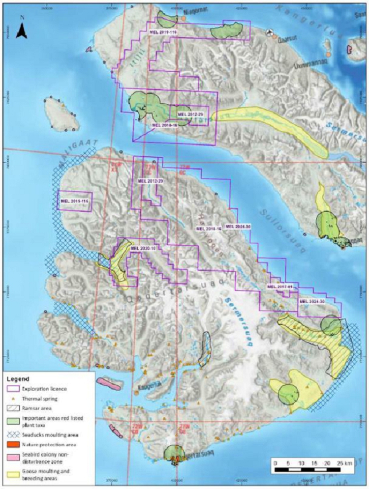
Sources: SRK, 2026
| SRK EXPLORATION LIMITED ■ JUNE 2026 | 142 |
| Technical Report Summary for the Disko-Nuussuaq Project |
| ENVIRONMENTAL STUDIES, PERMITTING, AND SOCIAL OR COMMUNITY IMPACT |
| 17.2 | Potential ESG Implications |
The following issues may present a risk to the development of the project if not appropriately managed during future phases of project development.
| 17.2.1 | ESG Governance |
80 Mile is currently the operator of this project while USFM is providing funding for the exploration activities. Neither of these companies as yet have a formalised specific sustainability policy or management system in place which would influence how activities might be undertaken for this exploration project. However, 80 Mile has publicly stated their commitment to reducing their impact on the environment as well as the surrounding communities. These commitments need to be developed into management plans as well as site specific environmental and social procedures to ensure that the commitments of the exploration licences are adhered to, unnecessary disturbance is reduced and impacts on the surrounding environment are minimised.
| 17.2.2 | Land use |
The proposed exploration project location is remote with no settlements within close proximity. Due to this, it is not anticipated that the project activities will impact any communities. However, it is possible that some of the exploration sites within Nuussuaq are utilised by First Nations for traditional activities, including hunting. Currently there is limited information available and what is known is outdated, however, these land uses may affect activities within some areas during specific times of the year, resulting in exploration activities possibly needing to be scheduled around these times.
The presence of permafrost has become increasingly challenging due to the impacts of climate change. The completed boreholes will need to be closed as securely as possible to reduce any escape of greenhouse gases.
Potential issues that may require consideration include the following:
| ■ | Surface strength of permafrost areas for infrastructure siting and construction; and |
| ■ | Emissions from disturbance of permafrost in context of greenhouse gas footprint for the project. |
| 17.2.3 | Water Resources |
The exploration licences are situated within various drainage basins as well as potentially within close proximity to homeothermic springs as discussed in section 8.1.4. The latter are protected by Greenlandic legislation. The potential risk to the project is that some of the exploration areas may need to be relocated slightly as the homeothermic springs are protected areas and cannot be disturbed.
| 17.2.4 | Protected Areas / Areas of Importance |
The region where the exploration licences have been approved are highly sensitive with all of the areas being impacted by Protected Areas or designated as Areas of Importance. In Table 17-1 each exploration licence has been assessed to identify whether any areas of importance fall within these licences. The results are summarised below.
| SRK EXPLORATION LIMITED ■ JUNE 2026 | 143 |
| Technical Report Summary for the Disko-Nuussuaq Project |
| ENVIRONMENTAL STUDIES, PERMITTING, AND SOCIAL OR COMMUNITY IMPACT |
Table 17-1: Exploration licences impacted by Protected Areas or Areas of Importance.
| Exploration licence No. | Ramsar Site | Homeothermic Springs (refer to Section | Area of Importance (Plant Species) | Areas of Importance (seabird colonies and moulting areas) | Narwhal winter and spring area | |||||
| MEL-2018-16 | X | X | X | |||||||
| MEL-2012-29 | X | X | ||||||||
| MEL 2017-01 | X | |||||||||
| MEL-2024-30 | X | X | ||||||||
| MEL 2020-10 | X | X | ||||||||
| MEL-2019-116 | X | X |
Ramsar Sites
One of the main implications for this exploration project, specifically on Disko Island, is the location of the project in relation to Ramsar Sites that are protected in terms of Greenlandic legislation. This area is protected and legally no mining activities may be undertaken within the Ramsar site. This could impact the project’s future prospects if continued exploration within EL 2020-10 identifies a target that later can’t be extracted.
Exploration activities within a Ramsar site are required to follow a zero-impact protocol and must comply with the conditions set out in the Exploration Licence approval (EL 2020-10). Some of these conditions include:
Due to the presence of birds, distance set off requirements are tightened and specific field rules governing for local flights are in place, specifying altitude restrictions.
Regarding eider colonies, the distance requirements specified in the Executive Order on birds § 12 applies.
Between 15 April and 15 September, no shooting or disturbance of bird colonies are allowed. This includes all sailing over 3 knots, within 200 meters if the bird colony is an island or a peninsula inhabited by eider, black guillemot, Atlantic puffins, arctic tern, gulls other than black legged kittiwake.
Areas of Importance
In addition to the Ramsar site, the other exploration licences all have areas of importance located within them, where certain restrictions on activities are necessary:
Important areas with red-listed plant taxa
Seabird colonies – restrictions include:
| – | No drone zone of 100m | |
| – | No drone zone of vertical distance of 500m |
| SRK EXPLORATION LIMITED ■ JUNE 2026 | 144 |
| Technical Report Summary for the Disko-Nuussuaq Project |
| ENVIRONMENTAL STUDIES, PERMITTING, AND SOCIAL OR COMMUNITY IMPACT |
| – | Non-disturbance zone of 200m |
Goose moulting and breeding areas
The rules1 for undertaking field work within areas of importance are detailed in Rules for field work and reporting regarding Mineral resources in Greenland (Ref no. 69.03.20+01, Nov 2000) and provide all the detail with regards to undertaking work within the areas, with regards to this project the area of importance are seabird colonies.
Narwhal winter and spring area
During the spring, narwhals rely on e ice starts to thaw and recede and migrate towards the coastal bays which means they frequent these areas during winter and spring (1 October – 31 July) thus Narwhal Winter and Spring Field Rules2 apply where narwhals are observed.
| 17.3 | ESG Conclusions and Recommendations |
The ESG review has identified potential risks related to governance, land use, permafrost and sensitive receptors. Further work is required to better understand these risks and the impacts for the project.
Specific recommendations include;
| ■ | In parallel with the drilling program develop a detailed map of the protected areas, areas of importance and homeothermic springs within the ELs. Verify locations and where possible avoid these areas. | |
| ■ | Develop and implement an environmental and social management system components (policies, risks and impact registers, plans and reports) to structure environmental and social activities that identify and address key issues. | |
| ■ | Plan and implement stakeholder engagement especially with governmental departments and traditional land users associated with the protected areas/ areas of importance. | |
| ■ | Develop a roadmap of activities and timings required to obtain future environmental and social approvals (permitting process and surface rights acquisition). | |
| ■ | The impact that infrastructure and equipment may have on permafrost should be investigated as well as, where possible, management measures should be implemented to prevent adverse effects of such on permafrost. These management measures should include the correct disposal and discharge of pollutants and waste associated with the project | |
| ■ | Areas of further work to consider as the Project progresses, include: |
1 Field Rules are strict requirements designed to protect the environment and cultural heritage of an area when condusting oh-shore field work related to a mineral resource activity. Accessed on 1 July 2026 (https://govmin.gl/wp-content/uploads/2020/03/Rules_for_Fieldwork_and_Reporting_regarding_Mineral_Resources.pdf)
2 https://natur.gl/wp-content/uploads/2024/04/2.03.15-Important-areas-for-Narwhal-winter-and-spring.pdf (Accessed 1 July 2026)
| SRK EXPLORATION LIMITED ■ JUNE 2026 | 145 |
| Technical Report Summary for the Disko-Nuussuaq Project |
| ENVIRONMENTAL STUDIES, PERMITTING, AND SOCIAL OR COMMUNITY IMPACT |
| ■ | Commission appropriate scale studies to evaluate baseline environmental and social-economic conditions on site, particularly in relation to climate, water and biodiversity. | |
| ■ | Undertake site-specific assessment of potential impacts arising from current (exploration) and future (construction and operational, when the time comes) project activities. Define and implement appropriate measures to manage these impacts at the appropriate times; | |
| ■ | Continuing to identify and engage (at the appropriate time) with key stakeholders. |
| SRK EXPLORATION LIMITED ■ JUNE 2026 | 146 |
| Technical Report Summary for the Disko-Nuussuaq Project |
| CAPITAL AND OPERATING COSTS |
| 18 | CAPITAL AND OPERATING COSTS |
Not currently applicable to this project.
| SRK EXPLORATION LIMITED ■ JUNE 2026 | 147 |
| Technical Report Summary for the Disko-Nuussuaq Project |
| ECONOMIC ANALYSIS |
| 19 | ECONOMIC ANALYSIS |
Not currently applicable to this project.
| SRK EXPLORATION LIMITED ■ JUNE 2026 | 148 |
| Technical Report Summary for the Disko-Nuussuaq Project |
| ADJACENT PROPERTIES |
| 20 | ADJACENT PROPERTIES |
Exploration licences immediately adjacent to Nikkeli’s properties include those owned by Anglo American PLC and their subsidiary NAIP West Exploration A/S (Figure 20-1). It is understood that Anglo American is targeting the same deposit type as 80 Mile, but details of their exploration activities are not reported in the public domain and the QP has not been able to verify any information in this regard.
Figure 20-1: Map showing the licences around Disko Island
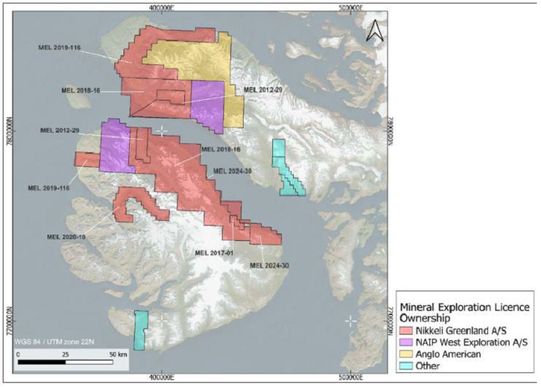
Sources: SRK Exploration, 2026; MLSA
Notes: *Anglo American Exploration Overseas Holdings Limited
| SRK EXPLORATION LIMITED ■ JUNE 2026 | 149 |
| Technical Report Summary for the Disko-Nuussuaq Project |
| OTHER RELEVANT DATA AND INFORMATION |
| 21 | OTHER RELEVANT DATA AND INFORMATION |
There is no other information relevant to the project at this time.
| SRK EXPLORATION LIMITED ■ JUNE 2026 | 150 |
| Technical Report Summary for the Disko-Nuussuaq Project |
| INTERPRETATION AND CONCLUSIONS |
| 22 | INTERPRETATION AND CONCLUSIONS |
| 22.1 | Introduction |
In preparing this TRS, SRK EX has also conducted some new analysis and modelling of the geochemical and geophysical data acquired since 2017. The outcomes of this are presented in the following sections.
| 22.2 | Interpretations of Geochemical Data |
| 22.2.1 | Rock Geochemistry |
SRK EX has used analytical data to distinguish various geochemical groups of rock types by applying a series of statistical analyses that take into account the different lithologies and the different characteristics of the samples, including Principal Component Analysis (“PCA”) to reduce data dimensionality and Uniform Manifold Approximation and Projection (“UMAP”), which preserves both local relationships and the global structure of the original dataset. The main groups identified are those dominated by Ni and those dominated by Cu (Figure 22-1). The former is thought to represent a mafic–ultramafic source and primarily primary magmatic crystallisation, whilst the latter is thought to represent a more fractionated crystallisation process with Cu enrichment. The second group of rocks would represent the most advanced stage of the system, during which segregation would take place to form economically significant sulphide mineralisation.
Figure 22-1: Interpretation of rock groups
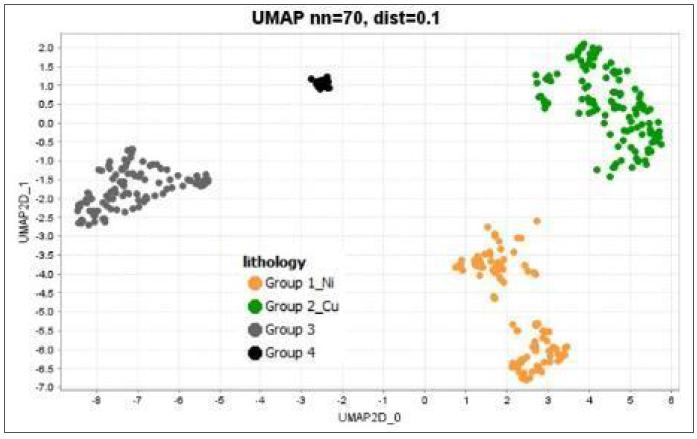
| SRK EXPLORATION LIMITED ■ JUNE 2026 | 151 |
| Technical Report Summary for the Disko-Nuussuaq Project |
| INTERPRETATION AND CONCLUSIONS |
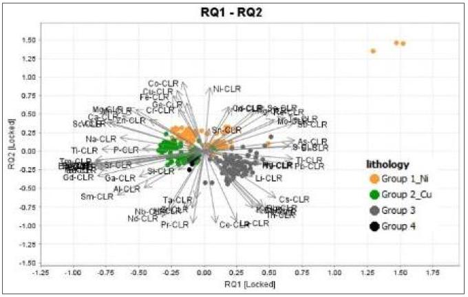
Sources: SRK EX, 2026
Notes: Upper image: A diagram generated from the UMAP analysis, showing the four clearly defined clusters. Lower image: a diagram generated from the PCA analysis, showing the four clusters correlated with different groups of elements, which would indicate the dominant mineralisation process.
SRK EX’s interpretation of this data is supportive of there being a magmatic system that favourable for the targeted deposit type, with high crustal contamination and evidence of the formation of mafic-ultramafic accumulations (Figure 22-2). These two characteristics are fundamental in determining the system’s fertility, increasing sulphide saturation, incorporating Ni, Cu and PGE, and promoting the separation of an immiscible sulphide phase.
However, the system appears to be primarily in a phase characterised by metal richness and transit, rather than one that demonstrates economic accumulation (Figure 22-3). As the diagrams of massive sulphide formation show, there are very few samples and are not representative of economic mineralisation. This may be because the mineralisation lies at a depth below the surface.
| SRK EXPLORATION LIMITED ■ JUNE 2026 | 152 |
| Technical Report Summary for the Disko-Nuussuaq Project |
| INTERPRETATION AND CONCLUSIONS |
Figure 22-2: Magmatic System Fertility
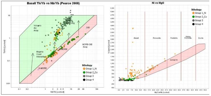
Sources: SRK EX, 2026
Notes: Left: Diagram illustrating the relationship between the ratios of the incompatible and immobile elements Th/Yb and Nb/Yb, to characterise the crustal contamination of the ascending magma. Right: a geochemical variation plot used to trace fractional crystallisation processes and assess the degree of partial melting or the origin of the magma. The orange plots (Group 1_Ni) indicate a mafic-ultramafic magma origin (Primary Magmatic System).
Figure 22-3: Massive Sulphide Generation
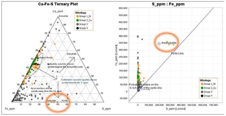
Sources: SRK EX, 2026
Notes: The orange circles indicate the formation of sulphides.
| SRK EXPLORATION LIMITED ■ JUNE 2026 | 153 |
| Technical Report Summary for the Disko-Nuussuaq Project |
| INTERPRETATION AND CONCLUSIONS |
| 22.2.2 | Stream Sediment Geochemistry |
Stream sediment samples corroborate these conclusions by demonstrating a differentiated magmatic system, the presence of more favourable zones associated with enrichment in Cu and PGE, and localised Ni anomalies. As can be seen in Figure 22-4, a Pd/Pt ratio >1 and Cu>Ni enrichment characterise the samples in a more geochemically fractionated sector, whilst samples with a Pd/Pt ratio <1 and a Cu<Ni ratio correspond to a primary mafic-ultramafic (Barnes, 1990).
Figure 22-4: Magmatic fractionation and sulphide segregation into Stream Sediments Samples
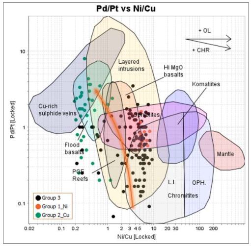
Sources: SRK EX, 2026
Notes: The orange arrow indicates the geochemical fractionation zone
| 22.2.3 | Soil Geochemistry |
The most representative soil samples are those obtained from the C horizon, as it can be inferred that this exhibits less geochemical dispersion, which increases towards the surface. Robust Pd anomalies were identified, characterised by a Pd/Pt ratio > 3 with an SW–NE trend. The anomalies were identified through a statistical analysis of the sample set. This process was carried out by transforming the data using the Centred Log Ratio (“CLR”). Levels were defined as background (green), anomalous (orange), and strongly anomalous (red). The samples show a high degree of geochemical dispersion, typical of the glacial environment in the project area (Figure 22-5).
| SRK EXPLORATION LIMITED ■ JUNE 2026 | 154 |
| Technical Report Summary for the Disko-Nuussuaq Project |
| INTERPRETATION AND CONCLUSIONS |
As mentioned earlier in this report, magmatic deposits of Ni, Cu and platinum group element (PGE) sulphides form when magmas derived from the mantle become saturated with sulphur and segregate immiscible fluids. The geochemical signature of these deposits is compared with the composition of the primitive mantle using normalised diagrams, revealing relative concentrations resulting from partial melting and fractionation. The figure (Figure 22-6) shows the following conclusions:
| ■ | Ni depletion: The primitive mantle is rich in nickel, which results in high concentrations in komatiites and basaltic deposits. In this case, the depletion of this element would suggest that it has been enriched elsewhere. | |
| ■ | Enrichment of Cu and Pd: Highly incompatible during partial melting. It tends to become enriched in magmas as the melt evolves, separating from base metals and remaining soluble until late stages of sulphide formation. |
Figure 22-5: Pd Anomalies in soil samples
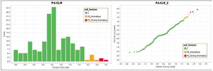
Sources: SRK EX, 2026
Figure 22-6: Ni-Cu-PGE in soil samples relative to primitive mantle
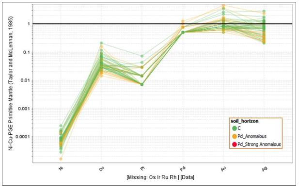
Sources: SRK EX, 2026
| SRK EXPLORATION LIMITED ■ JUNE 2026 | 155 |
| Technical Report Summary for the Disko-Nuussuaq Project |
| INTERPRETATION AND CONCLUSIONS |
| 22.2.4 | SRK EX Recommendation |
Mineralisation with economic potential is likely to be found at depth; consequently, the most significant anomalies are those reflecting processes of sulphide segregation and fractionation, particularly those associated with Pd, Pt and Au.
SRK EX recommends that the priority targets should be those areas where strong Pd anomalies, Cu-PGE enrichment, strong Pd anomalies in nearby stream sediment samples and areas where the SW–NE structural trend coincide, as these represent the most likely locations for the presence of sulphide traps within magmatic conduits. On this basis, the most encouraging areas appear to be the Qullissat and Igdlukunguaq areas (Figure 22-7).
Figure 22-7: Geochemical Interpretation
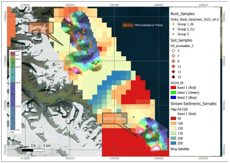
Sources: SRK EX, 2026
| 22.3 | Geophysical Data Interpretation |
SRK EX has built on KoBold’s work on the Falcon gravity data acquired in 2022. Three-dimensional modelling of the gravity data for key areas has been completed and has provided a valuable tool for drill targeting. The outcome of has confirmed the principal anomalies identified by KoBold and has provided information on the potential geometry of the causative features.
All the gravity anomalies are fairly weak and, in some places, only indicate slight increases in density compared to the surrounding rock. However, their geometry is consistent with what would be expected from intrusive dykes and sills – possible conduits that could host sulphide mineralisation. The strongest anomalies are observed in Qullissat and the northern Kuugannguaq Valley.
| SRK EXPLORATION LIMITED ■ JUNE 2026 | 156 |
| Technical Report Summary for the Disko-Nuussuaq Project |
| INTERPRETATION AND CONCLUSIONS |
In Qullissat, gravity features exhibit a NNW trend that is consistent with dykes associated to the Vaigat Formation, and in agreement with the gravity target highlighted by KoBold. They also show some correlation to electromagnetic anomalies identified in previous work, and with intrusive rocks intercepted by Falconbridge’s drilling. They are vertically extensive, relatively narrow and steeply-dipping or vertical, consistent with them potentially representing dykes. These are targets worthy of further investigation. There is also a NE-trending feature below the river immediately south of Qullissat town. The origin of this is unclear and could be related to terrain but is of interest due to the possibility that the river valley represents a fault structure that could have been intruded.
In the northern Kuugannguaq Valley, there is a series of north-trending anomalies of similar contrast to those at Qullissat. These are significant because they lie on the K-Q fault, a major deep-seated structure that could be an important competent of a nickel mineral system. These anomalies also coincide with conductors identified by the 2012 ZTEM survey and therefore represent important targets.
The southeastern Kuugannguaq Valley shows a fairly extensive gravity anomaly at the southeastern end of the survey grid. The western side of this appears to be truncated, possibly by a north-south trending fault. This could be a structural setting of interest. It is cautioned that one of Falconbridge’s holes was drilled on the edge of this anomaly and ended in basement gneiss. It is possible that the gravity anomaly could therefore represent part of the basement ridge that runs through Disko Island rather than being part of a mineralising system.
In the Aaffarsuaq Valley, gravity features show an easterly trend. One, on the northern side of the valley, is well-defined and should be investigated further. There are also anomalies, albeit more subtle, on the southern side of the valley roughly confident with the IP anomaly that Vismand attempted to drill in 2007. This justified further investigation.
Data for the Igdlukunguaq area shows only very weak gravity anomalies compared to other areas. There is no significant anomaly associated with the Igdlukunguaq dyke, although it does occur on the edge of a gravity feature. Compared to other areas, anomalies seem more tabular and may be caused by rafts of basalt that have been deposited along the coast by rockslides. This is supported by geological mapping for this area.
| 22.4 | Concluding Remarks |
The Disko–Nuussuaq Project occupies a promising geological setting for the discovery of magmatic Ni–Cu–Co–PGE sulphide mineralisation. The project area is situated within the Palaeogene West Greenland Flood Basalt Province, a part of the North Atlantic Igneous Province (“NAIP”) which is one of the Earth’s major Large Igneous Provinces (LIPs). This volcanic event provided the high-temperature, mantle-derived, picritic magmas essential for transporting and concentrating chalcophile and siderophile metals. The deposit model predicts that these magmas were emplaced through a system of feeder conduits and subvolcanic intrusions into the Cretaceous Nuussuaq Sedimentary Basin which includes carbonaceous and sulphidic units, potentially generating the crustal contamination and sulphide immiscibility conditions required for nickel sulphide mineralisation. Major deep-seated strike-slip fault system such as the Kuugannguaq– Qunnilik structural corridor, provided the tectonic architecture to focus and channel magmatic flow at multiple crustal levels. This mineralising environment is comparable to those that host the world’s major conduit-style nickel districts.
| SRK EXPLORATION LIMITED ■ JUNE 2026 | 157 |
| Technical Report Summary for the Disko-Nuussuaq Project |
| INTERPRETATION AND CONCLUSIONS |
The geological similarity of Disko–Nuussuaq to the Norilsk–Talnakh district of Russia – the world’s largest magmatic Ni-Cu-PGE system –is well established and recognised by successive explorers and the Geological Survey of Denmark and Greenland (“GEUS”). Both provinces share a LIP tectonic setting, conduit- and sill-style emplacement into sedimentary host sequences, a dominant role for crustal contamination as the sulphide saturation mechanism, and primitive picritic magma compositions indicative of fertile, metal-charged mantle sources. The Norilsk resource, exceeding 2.1 billion tonnes containing approximately 15.5 Mt Ni, 29.8 Mt Cu, and 337 Moz PGE, demonstrates the exceptional scale achievable in this deposit class. Geochemical data acquired during recent and historical exploration displays elevated palladium anomalies with Pd/Pt ratios indicative of sulphide fractionation, Cu–PGE enrichment in stream sediments, and rock geochemical signatures consistent with high-throughput magmatic conduits with evidence of crustal assimilation. These geochemical characteristics provide positive support for the metallogenic fertility of the system.
Despite a long exploration history stretching from prospecting in the 1870s through to systematic multi-phase programmes from the 1980s to 2022, economic occurrences of sulphide mineralisation at Disko–Nuussuaq are yet to be found and the project remains at an early stage of exploration.
Historical drilling was limited in extent, largely shallow (apart from deep drilling for hydrocarbons), and frequently hampered by difficult conditions including non-lithified sediments, permafrost and gas overpressures. Many holes were abandoned and few reached sufficient depth to confirm the presence of deeper-seated feeder conduits and structurally-controlled magma pathways that are most prospective for economic mineralisation. The ore-hosting intrusions at Norilsk–Talnakh lie at depth, beneath the surface volcanic sequence. This is a key component of the exploration model at Disko–Nuussuaq. Geochemical evidence further supports this interpretation as the available surface and near-surface data indicate a system characterised by metal richness and transit, with economic accumulation most likely occurring at depths as yet untested.
Geophysical surveys data, combined with three-dimensional gravity modelling completed by SRK EX, have been used to define at set of drill targets at Qullissat, the Aaffarsuaq Valley, along the Kuugannguaq structural corridor and along the Itilli Fault in western Nuussuaq. At Qullissat and in the northern Kuugannguaq Valley, gravity anomalies coincide with electromagnetic conductors identified by earlier surveys and exhibit the inferred trace of deep-seated fault structures. This may indicate the multi-parameter signature associated with conduit emplacement and sulphide accumulation in analogous districts. Targeting is supported by Pd-anomalous soil geochemistry and by stream sediment data indicative of sulphide segregation. Geophysical and geochemical data together define drilling targets that are technically robust and justify first-pass deep drilling.
SRK EX concludes that Disko–Nuussuaq project represents aa geologically compelling and underexplored terrane with high potential for significant Ni-Cu-Co-PGE mineralisation in magmatic sulphides. The scale of the prospective magmatic system and evidence from exploration and research justify continued and systematic exploration. The planned diamond drill programme, targeting the highest-priority geophysical anomalies and structurally prospective settings will represent a material advance in evaluating the mineral potential of the project.
| SRK EXPLORATION LIMITED ■ JUNE 2026 | 158 |
| Technical Report Summary for the Disko-Nuussuaq Project |
| RECOMMENDATIONS |
| 23 | RECOMMENDATIONS |
Following a review of the geological, geophysical, and geochemical evidence summarised in this report, SRK EX recommends that USFM Corporation proceeds with a two-phase exploration programme at the Disko-Nuussuaq Project. Phase 1 comprises the scout diamond drilling programme planned for the 2026 field season. Phase 2, contingent on Phase 1 results, would involve systematic follow-up drilling of the most prospective targets identified.
| 23.1 | Phase 1: Scout Diamond Drilling Programme (2026) |
SRK EX recommends the completion of nine diamond drill holes totalling approximately 8,200 m, as summarised in Table 23-1 and shown in Figure 23-1. The programme has been designed to test a broad range of geophysical anomalies and structural settings across the Qullissat, Aaffarsuaq Valley, Kuugannguaq, and western Nuussuaq areas. The geographic and geological diversity represented by the planned locations is deliberate: at this early stage of exploration, it is important to establish which geological environments and anomaly types are most prospective than to focus on a single target. The holes test a variety of geophysical signatures, structural settings, and stratigraphic positions, aiming to maximise the geological understanding of the region and provide the strongest possible foundation for further exploration.
In several locations, drillholes that target anomalies or structures associated with the Vaigat Formation have been prioritised, this being a substantial body of picritic and basaltic rocks that are considered most prospective for magmatic Ni–Cu–Co–PGE mineralisation at Disko–Nuussuaq. The Vaigat Formation may host intrusive conduits, sills, and feeder systems that are analogous to the ore-bearing units at Norilsk–Talnakh and Voisey's Bay. Differentiation of igneous units must be an important focus of geological logging, and it is recommended that all igneous units are sampled and analysed in order to generate geochemical vectors to prospective settings.
Previous drilling programmes have encountered numerous difficulties with bad ground, thick overburden and gas. A new drilling campaign must be prepared and equipped to overcome similar challenges.
| Table 23-1 | Phase 1 Scout Drill Hole Parameters — Disko–Nuussuaq Project (UTM Zone 22N, WGS84) |
| Hole ID |
Area | Easting | Northing | Elev. (m) |
Azi. (°) |
Dip (°) |
Depth (m) |
Target and Rationale |
| Q1 | Qullissat | 423304 | 7772529 | 487 | 070 | -65 | 1,000 | Tests NNW-trending gravity anomaly corroborated by historic EM conductors; targets conduit-style intrusion within the Vaigat Formation in the Qullissat block. Multiple coincident datasets make this a priority hole. |
| Q3 | Qullissat | 422458 | 7777152 | 216 | 245 | -60 | 1,000 | Second Qullissat test, 4.6 km north of Q1. Designed to assess lateral continuity along the interpreted NNW corridor of any intrusive system intersected by Q1. |
| Q4 | Qullissat | 425426 | 7771103 | 79 | 310 | -60 | 600 | Shallower hole targeting a north-east-trending feature below the Qullissat river valley interpreted as a potential fault-intruded corridor. |
| SRK EXPLORATION LIMITED ■ JUNE 2026 | 159 |
| Technical Report Summary for the Disko-Nuussuaq Project |
| RECOMMENDATIONS |
| Hole ID |
Area | Easting | Northing | Elev. (m) |
Azi. (°) |
Dip (°) |
Depth (m) |
Target and Rationale |
| AF1 | Aaffarsuaq Valley | 410124 | 7818172 | 201 | 192 | -75 | 1,000 | Tests the primary gravity anomaly in the Aaffarsuaq Valley identified in SRK EX 3D modelling. Target is a steeply-dipping, E-trending interpreted intrusive body. |
| AF2 | Aaffarsuaq Valley | 407150 | 7817130 | 172 | 000 | -90 | 1,000 | Located ~750 m east of V-GRN-2, targeting a gravity feature identified in SRK EX and KoBold models, and a historical IP anomaly. Glacio-fluvial overburden in this area is likely to be >150 m thick. |
| KN1 | Kuugannguaq North | 389707 | 7793289 | 80 | 080 | -60 | 600 | Tests north-trending gravity anomalies on the K–Q fault — a major deep-seated strike-slip structure regarded as a first-order control on magma migration. Gravity anomalies here coincide with historical ZTEM conductors. |
| KSE1 | Kuugannguaq SE | 401433 | 7776368 | 282 | 110 | -60 | 1,000 | Tests a broad gravity anomaly at the southeast end of the Kuugannguaq Valley. Structurally positioned adjacent to an interpreted N–S-trending fault. |
| NU1 | Nuussuaq Peninsula | 381169 | 7836334 | 283 | 000 | -90 | 1,000 | This area has limited historical drilling or geophysical coverage. Vertical hole targeting subsurface Hole is designed to test the Vaigat Fm on the Itilli Fault, a major structure and possible focus of magmatic conduits. |
| NU2 | Nuussuaq Peninsula | 393598 | 7851504 | 225 | 000 | -90 | 1,000 | 12 km east-northeast of NU1, also in the Vaigat Fm, designed to further test prospectivity along the Itilli Fault and assess its role as part of the NAIP plumbing system. |
Notes: Coordinates in UTM Zone 22N, WGS84. Dips are negative below horizontal. Target depths are indicative; the programme is designed to be reactive to geology intersected and hole lengths may be adjusted depending on observed intersections during drilling. Collar locations may be moved following field inspection of accessibility and terrain.
| SRK EXPLORATION LIMITED ■ JUNE 2026 | 160 |
| Technical Report Summary for the Disko-Nuussuaq Project |
| RECOMMENDATIONS |
| Figure 23-1: | 80 Mile planned drilling with historic holes across the Disko-Nuussuaq Project |
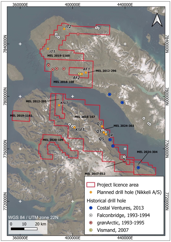
| Sources: Nikkeli, A/S, SRK EX, 2026 |
| SRK EXPLORATION LIMITED ■ JUNE 2026 | 161 |
| Technical Report Summary for the Disko-Nuussuaq Project |
| RECOMMENDATIONS |
Downhole geophysical surveys should be considered for drillholes that intersect mineralisation or features that may be mineralised. Downhole methods of particular relevance include Time-Domain Electromagnetic (“TDEM”) / Borehole EM (“BHEM”). This is commonly used for detection of off-hole conductors that may relate to massive sulphides. BHEM has potential to detect conductive bodies up to several hundred metres from the drillhole, depending on the size of the mineralised body and the nature of the host rock, enabling identification of possible mineralisation that the hole itself may have missed. Given the known difficulty of directly intersecting the relatively small but high-grade sulphide accumulations characteristic of conduit-style deposits, BHEM surveys may be of value in targeting later phases of drilling.
USFM has estimated a budget of approximately USD 10 million to complete this first phase of work. The QP considers this to be reasonable and justified.
| 23.2 | Phase 2: Follow-Up Drilling |
Phase 2 of the exploration programme should be designed based on Phase 1 results. Subject to positive geological and geophysical results from Phase 1 (including the intersection of Vaigat Formation intrusions exhibiting sulphide segregation textures, chalcophile element depletion, or proximal BHEM conductors), SRK EX recommends that a follow-up drilling programme be designed to:
| ■ | Deepen holes that intersected anomalous geochemistry or favourable lithologies but did not reach their primary target at the planned depth; |
| ■ | Infill-test the most prospective areas with additional holes to establish the geometry of mineralised intrusive systems; |
| ■ | Test off-hole BHEM targets identified during Phase 1 surveys, prioritising conductors with a plate geometry and conductance consistent with massive sulphide bodies; and |
| ■ | Acquire additional surface geophysical data (EM, IP, or gravity infill) in areas where Phase 1 results indicate the potential for mineralisation between drill sections. |
Phase 2 recommendations will be developed and presented to USFM Corporation following completion of Phase 1 drilling and the receipt of laboratory assay results. The exploration budget for Phase 2 will be dependent on these recommendations.
| SRK EXPLORATION LIMITED ■ JUNE 2026 | 162 |
| Technical Report Summary for the Disko-Nuussuaq Project |
| REFERENCES |
| 24 | REFERENCES |
80 Mile plc (2025) ‘The Disko-Nuussuaq Ni-Cu-Co-PGM-Au Project’ [Investor Presentation].
Alsulami, S., Paton, D.A. and Cornwell, D.G. (2015) 'Tectonic variation and structural evolution of the West Greenland continental margin', AAPG Bulletin, 99(9), pp. 1689-1711.
Amec Foster Wheeler Earth and Environmental (UK) Ltd. (2015) Independent Technical Report prepared for Avannaa Resources Limited: The Disko-Nuussuaq Cu-Ni-PGE Project, West Greenland. [Report] Submitted to Avannaa Resources Limited.
Andersen, J.C.Ø., Rollinson, G.K., McDonald, I., Tegner, C. and Lesher, C.E. (2017) 'Platinum-group mineralization at the margin of the Skaergaard intrusion, East Greenland', Mineralium Deposita, 52, pp. 675-699.
Avannaa Resources (2014) Technical report on the 2013 exploration program at Kuugannguaq, North Disko, West Greenland: work carried out under prospecting license 2012/29. GEUS Report File No. 23781. Avannaa Exploration Ltd., March 2014.
Barnes (2023) Lithogeochemistry in exploration for intrusion-hosted magmatic Ni–Cu–Co deposits. https://doi.org/10.1144/geochem2022-025 | Vol. 23 | 2023 | geochem2022-025.
Barnes, S.J. and Robertson, J.C. 2019. Time scales and length scales in magma flow pathways and the origin of magmatic Ni-Cu-PGE ore deposits. Geoscience Frontiers, 10, 77–87, https://doi.org/10.1016/j.gsf.2018.02.006.
Bernstein, S., Kelemen, P.B. and Brooks, C.K. (1996) 'Evolution of the Kap Edvard Holm Complex: a mafic intrusion at a rifted continental margin', Journal of Petrology, 37(3), pp. 497-519.
Blichert-Toft, J., Lesher, C.E. and Rosing, M.T. (1992) 'Selectively contaminated magmas of the Tertiary East Greenland macrodike complex', Contributions to Mineralogy and Petrology, 110, pp. 154-172.
Bluejay Mining plc (2022) ‘2022 Disko-Nuussuaq Field Programme Successfully Completed’. Press release. Available at: [www.80mile.com] (Accessed: [18/05/2026]).
Brooks, C.K. and Nielsen, T.F.D. (1978) 'Early stages in the differentiation of the Skaergaard magma as revealed by a closely related suite of dike rocks', Lithos, 11, pp. 1-14.
Brooks, K. (2015) 'Native iron: Greenland's natural blast furnaces', Geology Today, 31(5), pp. 176-182.
Chalmers, J.A., Pulvertaft, T.C.R., Marcussen, C. and Pedersen, A.K. (1999) 'New insight into the structure of the Nuussuaq Basin, central West Greenland', Marine and Petroleum Geology, 16(3), pp. 197-224.
Dam, G., & Christiansen, F. G. (1994). Well summary Marraat-1, Nuussuaq – West Greenland (Open File Series 94/11). Grønlands Geologiske Undersøgelse (Geological Survey of Greenland).
| SRK EXPLORATION LIMITED ■ JUNE 2026 | 163 |
| Technical Report Summary for the Disko-Nuussuaq Project |
| REFERENCES |
Dam, G., Pedersen, G.K., Sønderholm, M., Midtgaard, H.H., Larsen, L.M., Nøhr-Hansen, H. and Pedersen, A.K. (2009) Lithostratigraphy of the Cretaceous-Paleocene Nuussuaq Group, Nuussuaq
Basin, West Greenland. Geological Survey of Denmark and Greenland Bulletin 19. Copenhagen: Geological Survey of Denmark and Greenland.
Danish Centre for Environment and Energy (DCE). Disko Island and Nuussuaq Peninsula, West Greenland. Strategic Environmental Impact Assessment of petroleum exploration and exploitation (2016).
Deng, Y.-F., Song, X.-Y., Hollings, P., Chen, L.-M., Zhou, T., Yuan, F., Xie, W., Zhang, D. and Zhao, B. (2017) 'Lithological and geochemical constraints on the magma conduit systems of the Huangshan Ni-Cu sulfide deposit, NW China', Mineralium Deposita, 52, pp. 709-725.
Geoscience frontiers (2011).
Gill, R.C.O., Nielsen, T.F.D., Brooks, C.K. and Ingram, G.A. (1992) 'Tertiary volcanism in the Kangerdlugssuaq region, E Greenland: trace-element geochemistry of the Lower Basalts and tholeiitic dyke swarms', Geological Society, London, Special Publications, 68, pp. 161-179.
Gregersen, U., Hopper, J.R., Knutz, P.C., Nielsen, T., Petersen, J.A., Sheldon, E. and Dybkjær, K. (2019) 'Tectonostratigraphy and evolution of the West Greenland continental margin', Bulletin of the Geological Society of Denmark, 67, pp. 1-21.
Henriksen, N., Higgins, A.K., Kalsbeek, F. and Pulvertaft, T.C.R. (2000) Greenland from Archaean to Quaternary: descriptive text to the Geological map of Greenland, 1:2 500 000. Geology of Greenland Survey Bulletin 185. Copenhagen: Geological Survey of Denmark and Greenland.
Holness, M.B., Humphreys, M.C.S., Namur, O., Andersen, J.C.Ø., Tegner, C. and Nielsen, T.F.D. (2022) 'Crystal mush growth and collapse on a steep wall: the Marginal Border Series of the Skaergaard Intrusion, East Greenland', Journal of Petrology, 63(1), egab100.
Holness, M.B., Stripp, G., Humphreys, M.C.S., Veksler, I.V., Nielsen, T.F.D. and Tegner, C. (2011) 'Silicate liquid immiscibility within the crystal mush: late-stage magmatic microstructures in the Skaergaard Intrusion, East Greenland', Journal of Petrology, 52(1), pp. 175-222.
Holwell, D.A., Abraham-James, T., Keays, R.R. and Boyce, A.J. (2011) 'The nature and genesis of marginal Cu-PGE-Au sulphide mineralisation in Paleogene Macrodykes of the Kangerlussuaq region, East Greenland', Mineralium Deposita, 47, pp. 3-21.
Hy-Grade Geoscience (2007) Vismand Exploration Inc. 2007 Greenland Exploration Drilling Program: Work Report, Drill Holes #V-GRN-1, V-GRN-1A and V-GRN-2. Unpublished report prepared for Vismand Exploration Inc., Dartmouth, Nova Scotia.
Illig, P., Mansperger, M.O.L., Williams, N., Martinez, C. and Schlatter, D.M. (2023) Geological field report – MEL 2020-10: Disko Island – Nuussuaq peninsula Ni-Co-PGE exploration, West Greenland. Calendar year 2022. [Report]. Nikkeli.
Jackisch, R., Heincke, B.H., Zimmermann, R., Sørensen, E.V., Pirttijärvi, M., Kirsch, M., Salmirinne, H., Lode, S., Kuronen, U. and Gloaguen, R. (2022) 'Drone-based magnetic and multispectral surveys to develop a 3D model for mineral exploration at Qullissat, Disko Island, Greenland', Solid Earth, 13, pp. 793-825.
Jakobsen, J.K., Tegner, C., Brooks, C.K., Kent, A.J.R., Lesher, C.E., Nielsen, T.F.D. and Wiedenbeck, M. (2009) 'Parental magma of the Skaergaard intrusion: constraints from melt inclusions in primitive troctolite blocks and FG-1 dykes', Contributions to Mineralogy and Petrology, 159, pp. 61-79.
| SRK EXPLORATION LIMITED ■ JUNE 2026 | 164 |
| Technical Report Summary for the Disko-Nuussuaq Project |
| REFERENCES |
Jess, S., Stephenson, R., Roberts, D.H. and Brown, R. (2019) 'Differential erosion of a Mesozoic rift flank: establishing the source of topography across Karrat, central West Greenland', Geomorphology, 334, pp. 138-150.
KoBold Metals Team, 2023. Disko Update. [PowerPoint presentation] May 2023.
Larsen, L.M. and Pedersen, A.K. (2009) 'Petrology of the Paleocene picrites and flood basalts on
Disko and Nuussuaq, West Greenland', Journal of Petrology, 50(9), pp. 1667-1711.
Larsen, L.M., Pedersen, G.K., Nøhr-Hansen, H., Pedersen, A.K., Bojesen-Koefoed, J.A., Sørensen, E.V. and Lindström, S. (2024) 'A hidden succession revealed: Cretaceous and Paleocene sediments and a native-iron-bearing lava flow in cores near Qullissat, Disko, West Greenland', GEUS Bulletin, 57, article 8361.
Lesher (2019). Up, down, or sideways: emplacement of magmatic Fe–Ni–Cu–PGE sulfide melts in large igneous provinces. Can. J. Earth Sci. 56: 756–773 (2019) dx.doi.org/10.1139/cjes-2018-0177
Lightfoot and Hawkeworth (1997). Flood Basalts and Magmatic Ni, Cu, and PGE Sulphide Mineralization: Comparative Geochemistry of the Noril'sk (Siberian Traps) and West Greenland Sequences.
Lightfoot, D. Evans-Lamswood / Ore Geology Reviews 64 (2015) 354–386.
Lightfoot, P.C., Keays, R.R., Evans-Lamswood, D. and Wheeler, R. 2012. Saturation history of Nain plutonic suite mafic intrusions; origin of the Voisey’s Bay Ni-Cu-Co sulfide deposit, Labrador, Canada. Mineralium Deposita, 47, 23–50
Long, T.-M., Song, X.-Y., Kang, J., Liang, Q.-L., Wang, Y.-C., Li, D.-X., Ai, Q.-X., Suo, W.-D. and Lu, J.-Q. (2023) 'Genesis of No. 2 orebody of the Jinchuan magmatic Ni-Cu-(PGE) sulfide deposit, NW China: new constraints from the newly discovered deep extension', Mineralium Deposita, 58, pp. 1317-1332.
Maier, W.D., David, I.G. (2011). Temporal and spatial controls on the formation of magmatic PGE and Ni-Cu deposits [J]. MinerDeposita,2011,46:841-857.
Mao, X., Liu, P., Deng, H., Liu, Z., Li, L., Wang, Y., Ai, Q. and Liu, J. (2023) 'A novel approach to three-dimensional inference and modeling of magma conduits with exploration data: a case study from the Jinchuan Ni-Cu sulfide deposit, NW China', Natural Resources Research, 32, pp. 1201-1227.
Marshall, B. and Schønwandt, H.K. (1999) 'An Archaean sill complex and associated supracrustal rocks, Arveprinsen Ejland, north-east Disko Bugt, West Greenland', Geology of Greenland Survey Bulletin, 181, pp. 87-102.
McPhie, J., Doyle, M. and Allen, R. (1993) Volcanic textures: a guide to the interpretation of textures in volcanic rocks. Hobart: Centre for Ore Deposit and Exploration Studies, University of Tasmania.
| SRK EXPLORATION LIMITED ■ JUNE 2026 | 165 |
| Technical Report Summary for the Disko-Nuussuaq Project |
| REFERENCES |
Momme, P. and Wilson, J.R. (2002) 'The Kraemer Island macrodyke, East Greenland: solidification of a flood basalt conduit', Geological Magazine, 139(3), pp. 265-287.
NI 43-101 Technical Report on the Eagle Mine, Michigan, USA.
Olshefsky, K., & Jerome, M. (1992). Report on 1992 exploration activities for prospecting licence no. 156 and exploration licences 02/91, 03/91, 04/91, 25/92, West Greenland Tertiary Basalt Province. Falconbridge Limited.
Olshefsky, K., Jerome, M., Graves, M., & Evans-Lamswood, D. (1995). Report on 1994 exploration activities for prospecting licence 06/94 and exploration licences 02/91 & 03/91, West Greenland Tertiary Basalt Province. Falconbridge Greenland A/S / Falconbridge Limited.
Pauly, H. (1969) 'White cast iron with cohenite, schreibersite, and sulphides from Tertiary basalts on Disko, Greenland', Meddelelser fra Dansk Geologisk Forening, 19, pp. 8-26.
Pedersen, A. K. 1985. Reaction between picrite magma and continental crust: early Tertiary silicic basalts and magnesian andesites from Disko, West Greenland. Grønlands Geologiske Undersøgelse, Bulletin 152, 130 pp.
Pedersen, A.K., Larsen, L.M. and Pedersen, G.K. (2018) Lithostratigraphy, geology and geochemistry of the volcanic rocks of the Maligât Formation and associated intrusions on Disko and Nuussuaq, Paleocene of West Greenland. Geological Survey of Denmark and Greenland Bulletin 40. Copenhagen: Geological Survey of Denmark and Greenland.
Pedersen, A.K., Larsen, L.M., Pedersen, G.K. and Dueholm, K.S. (2006) 'Five slices through the Nuussuaq Basin, West Greenland', Geological Survey of Denmark and Greenland Bulletin, 10, pp. 53-56.
Pedersen, J.M., Ulrich, T., Whitehouse, M.J., Kent, A.J.R. and Tegner, C. (2021) 'The volatile and trace element composition of apatite in the Skaergaard intrusion, East Greenland', Contributions to Mineralogy and Petrology, 176, article 102.
Rosa, D. (2018) Magmatic nickel potential in Greenland. Geology and Ore 31. Copenhagen: Geological Survey of Denmark and Greenland.
RR. Colucci, A Securo, C Sigsgaard, C Del Gobbo, K Svennevig and M Citterio. (2025) Rapid mass movements triggered by an atmospheric river in Disko Island, West Greenland. Earth Surface Processes and Landforms. 50. 10.1002/esp.70201.
Saunders, A.D., Fitton, J.G., Kerr, A.C., Norry, M.J. and Kent, R.W. (1997) 'The North Atlantic Igneous Province', in Mahoney, J.J. and Coffin, M.F. (eds.) Large Igneous Provinces: Continental, Oceanic, and Planetary Flood Volcanism. Washington, DC: American Geophysical Union, pp. 45-93.
Song Xieyan, Yushan Wang, Liemeng Chen (2011). Magmatic Ni-Cu-(PGE) deposits in magma plumbing systems: Features, formation and exploration. GEOSCIENCE FRONTIERS 2(3) (2011) 375e384.
Starostin, V.I. & Sorokhtin, O.G. (2011). A New Interpretation for the Origin of the Norilsk-Type PGE–Cu–Ni Sulfide Deposits. Geoscience Frontiers, 2(4), 583–591.
| SRK EXPLORATION LIMITED ■ JUNE 2026 | 166 |
| Technical Report Summary for the Disko-Nuussuaq Project |
| REFERENCES |
Stendal, H. and Garde, A.A. (2004) 'Precambrian mineralising events in central West Greenland (66°-70°15'N)', Geological Survey of Denmark and Greenland Bulletin, 7, pp. 61-64.
St-Onge, M.R., Van Gool, J.A.M., Garde, A.A. and Scott, D.J. (2009) 'Correlation of Archaean and Palaeoproterozoic units between northeastern Canada and western Greenland: constraining the pre-collisional upper plate accretionary history of the Trans-Hudson orogen', Geological Society, London, Special Publications, 318, pp. 193-235.
Thrane, K., Steenfelt, A. and Kalvig, P. (2011) Zinc potential in North Greenland. Danmarks og Grønlands Geologiske Undersøgelse Rapport 2011/143. Copenhagen: Geological Survey of Denmark and Greenland.
| SRK EXPLORATION LIMITED ■ JUNE 2026 | 167 |
| Technical Report Summary for the Disko-Nuussuaq Project |
| RELIANCE ON OTHER EXPERTS |
| 25 | RELIANCE ON OTHER EXPERTS |
SRK EX has not performed an independent verification of land title and tenure information as summarised in Section 3 of this report. SRK EX did not verify the legality of any underlying agreement(s) that may exist concerning the permits or other agreement(s) between third parties but has relied on information provided by 80 Mile PLC on behalf of USFM. The reliance applies solely to the legal status of the rights disclosed in Section 3 below.
SRK EX was informed by USFM that there are no known litigations potentially affecting the Disko-Nuussuaq project.
| SRK EXPLORATION LIMITED ■ JUNE 2026 | 168 |

| Appendix A | Point Licence Co-ordinates |
| Licence Code | Point Co-ordinates |
| MEL 2019-116 | (394115.8, 7855748.7), (400149.4, 7853609.1), (400149.4, 7853609.1), (417906.4, 7852884.4), (417974.8, 7854742.1), (428377.6, 7854383.3), (428138.7, 7846951.5), (397444.8, 7848148.9), (397359.6, 7846291.9), (394902.7, 7846406.0), (394728.2, 7842692.0), (392267.4, 7842809.0), (392088.9, 7839095.2), (389624.0, 7839215.1), (389441.5, 7835501.5), (401169.7, 7834955.6), (401088.2, 7833098.4), (408502.8, 7832785.0), (408276.5, 7827212.8), (377931.2, 7828649.6), (378031.6, 7830506.0), (376175.9, 7830607.1), (376277.8, 7832463.4), (375041.7, 7832531.6), (375247.7, 7836244.1), (377098.8, 7836142.2), (377200.3, 7837998.5), (378433.4, 7837931.4), (378533.8, 7839787.8), (379766.0, 7839721.5), (379964.9, 7843434.3), (382425.1, 7843303.8), (382620.0, 7847016.9), (385690.4, 7846857.8), (385880.2, 7850571.1), (388332.6, 7850447.1), (388518.4, 7854160.6), (391578.9, 7854009.6), (391669.3, 7855866.4), (394115.8, 7855748.7) |
| MEL 2019-116 | (354299.3, 7789066.5), (367531.5, 7788267.0), (367104.5, 7780843.1), (353829.6, 7781644.8), (354299.3, 7789066.5) |
| MEL 2017-01 | (436083.4, 7755594.5), (439917.6, 7755492.9), (439869.9, 7753634.8), (441149.0, 7753602.3), (441102.3, 7751744.3), (443662.7, 7751681.3), (443573.3, 7747965.1), (441008.9, 7748028.1), (441055.6, 7749886.2), (438493.3, 7749952.0), (438542.1, 7751810.0), (435981.9, 7751878.5), (436083.4, 7755594.5), (436083.4, 7755594.5) |
| MEL 2024-30 | (423343.2, 7776186.8), (423448.8, 7776183.3), (423457.3, 7776121.1), (423510.1, 7776119.3), (423565.3, 7775869.5), (423860.9, 7775859.8), (423914.9, 7774928.1), (424263.4, 7774916.7), (424399.2, 7774540.3), (423279.4, 7774577.1), (423343.2, 7776186.8) |
| MEL 2024-30 | (431190.7, 7763171.5), (442019.6, 7762876.9), (441788.6, 7753586.4), (446905.3, 7753464.7), (446863.2, 7751606.6), (452624.3, 7751483.0), (452586.7, 7749624.8), (457712.0, 7749526.8), (457678.5, 7747668.4), (460884.4, 7747612.9), (460853.4, 7745754.5), (463420.2, 7745713.1), (463333.5, 7740138.0), (446610.5, 7740457.5), (446851.9, 7751111.0), (445871.7, 7751195.4), (445946.4, 7751658.5), (441103.1, 7751775.2), (441149.0, 7753602.3), (439869.9, 7753634.8), (439917.6, 7755492.9), (436083.4, 7755594.5), (436134.2, 7757452.5), (434857.1, 7757487.8), (434960.7, 7761203.8), (431135.8, 7761313.5), (431190.7, 7763171.5) |
| MEL 2012-29 | (387173.7, 7802110.6), (392811.3, 7801839.4), (392115.4, 7786984.2), (394006.9, 7786896.4), (393836.1, 7783182.5), (390047.0, 7783359.9), (390135.4, 7785216.8), (386349.6, 7785400.3), (387173.7, 7802110.6), (387173.7, 7802110.6) |
| MEL 2012-29 | (397494.4, 7822093.8), (412397.2, 7821468.3), (412109.9, 7814038.3), (404633.6, 7814339.6), (404711.5, 7816196.9), (397242.2, 7816522.7), (397494.4, 7822093.8), (397494.4, 7822093.8) |
| MEL 2018-16 | (383415.6, 7802299.1), (387173.7, 7802110.6), (386349.6, 7785400.3), (390135.4, 7785216.8), (390047.0, 7783359.9), (393836.1, 7783182.5), (394006.9, 7786896.4), (392115.4, 7786984.2), (392811.3, 7801839.4), (394690.7, 7801752.1), (394519.7, 7798038.2), (409580.9, 7797394.4), (409434.4, 7793679.6), (420750.9, 7793261.1), (420366.4, 7782114.9), (423525.4, 7782008.2), (423279.4, 7774577.1), (428350.4, 7774414.8), (428178.1, 7768841.2), (431355.2, 7768745.2), (431135.8, 7761313.5), (434960.7, 7761203.8), (434857.1, 7757487.8), (436134.2, 7757452.5), (435981.9, 7751878.5), (438542.1, 7751810.0), (438493.3, 7749952.0), (441055.6, 7749886.2), (441008.9, 7748028.1), (443573.3, 7747965.1), (443618.0, 7749823.2), (446821.0, 7749748.4), (446652.6, 7742315.7), (431872.7, 7742697.0), (432087.9, 7750128.7), (422480.5, 7750426.6), (422726.2, 7757857.5), (408043.8, 7758389.2), (408409.5, 7767676.0), (396331.2, 7768183.2), (396745.3, 7777468.3), (385983.6, 7777973.5), (386166.6, 7781686.9), (382374.9, 7781876.9), (383415.6, 7802299.1), (383415.6, 7802299.1) |
| MEL 2018-16 | (382298.7, 7807457.3), (383074.9, 7807900.8), (383551.0, 7817183.7), (383646.3, 7819040.3), (378672.6, 7819301.0), (379169.4, 7828583.0), (415710.4, 7826923.1), (414948.2, 7806489.6), (411197.6, 7806632.5), (382298.7, 7807457.3), (397494.3, 7822093.8), (397242.2, 7816522.7), (404711.5, 7816196.9), (404633.6, 7814339.6), (412109.9, 7814038.3), (412397.2, 7821468.3), (397494.4, 7822093.8) |
| MEL 2020-10 | (391333.1, 7770272.3), (391246.3, 7768415.5), (393153.0, 7768327.1), (393067.7, 7766470.1), (394340.0, 7766412.0), (394255.6, 7764555.1), (396802.2, 7764440.8), (396637.7, 7760726.8), (398550.8, 7760642.8), (398470.0, 7758785.7), (404214.1, 7758543.1), (403985.7, 7752971.4), (396948.4, 7753270.4), (397030.2, 7755127.5), (394473.4, 7755241.4), (394557.1, 7757098.4), (392002.5, 7757215.0), (392088.3, 7759071.9), (390173.9, 7759161.1), (390261.3, 7761017.9), (388986.1, 7761078.3), (389074.4, 7762935.1), (386526.1, 7763057.7), (386616.5, 7764914.4), (382160.9, 7765135.7), (382066.9, 7763279.1), (380792.9, 7763343.9), (380603.0, 7759630.9), (381241.0, 7759598.4), (381052.2, 7755885.3), (384886.5, 7755693.5), (384703.8, 7751980.2), (375743.3, 7752438.2), (375841.7, 7754294.5), (375202.3, 7754328.5), (375301.2, 7756184.9), (374023.3, 7756253.3), (374423.4, 7763678.4), (375697.2, 7763610.1), (375895.3, 7767322.8), (377167.1, 7767255.3), (377363.2, 7770968.0), (391333.1, 7770272.3) |
Sources: SRK EX, 2026
Notes: Co-ordinates in UTM Zone 22N, WGS84
| Appendix B | Drill collar information |
| Table 25-1: | Historical hole parameters for the Disko-Nuussuaq Project |
| Hole ID | Azimuth | Dip | Depth, m | Easting, m | Northing, m | Company, Year |
| FP93-5-1 | 52 | -70.0 | 50.60 | 440110.00 | 7752903.00 | Falconbridge, 1993 |
| FP93-5-2 | 52 | -72.0 | 50.90 | 439897.00 | 7753241.00 | Falconbridge, 1993 |
| FP93-5-3 | 52 | -73.0 | 40.84 | 439920.00 | 7753258.00 | Falconbridge, 1993 |
| FP93-5-4 | 52 | -61.0 | 36.27 | 439544.00 | 7753666.00 | Falconbridge, 1993 |
| FP93-5-5 | 52 | -89.0 | 70.41 | 439607.00 | 7753707.00 | Falconbridge, 1993 |
| FP93-5-6 | 52 | -86.0 | 62.18 | 439440.00 | 7753865.00 | Falconbridge, 1993 |
| FP93-3-1 | 308 | -61.0 | 138.68 | 401325.00 | 7777153.00 | Falconbridge, 1993 |
| FP93-3-2 | 128 | -51.0 | 185.63 | 399929.00 | 7777272.00 | Falconbridge, 1993 |
| FP93-3-3 | 270 | -64.5 | 181.97 | 397690.00 | 7778779.00 | Falconbridge, 1993 |
| FP94-11-1 | 0 | -90 | 51.20 | 419808.00 | 7852176.00 | Falconbridge, 1994 |
| FP94-11-2 | 0 | -90 | 422.76 | 419028.00 | 7852242.00 | Falconbridge, 1994 |
| FP94-11-3 | 0 | -90 | 31.10 | 419574.00 | 7851990.00 | Falconbridge, 1994 |
| FP94-11-4 | 0 | -90 | 340.46 | 418783.00 | 7852537.00 | Falconbridge, 1994 |
| FP94-11-5 | 0 | -90 | 230.73 | 418085.00 | 7852262.00 | Falconbridge, 1994 |
| FP94-9-1 | 0 | -90 | 537.10 | 387851.70 | 7846152.00 | Falconbridge, 1994 |
| FP94-9-2 | 0 | -90 | 127.00 | 387616.40 | 7847410.60 | Falconbridge, 1994 |
| FP94-9-3 | 0 | -90 | 97.50 | 387531.30 | 7847483.10 | Falconbridge, 1994 |
| FP94-9-4 | 0 | -90 | 180.20 | 389370.00 | 7845111.00 | Falconbridge, 1994 |
| FP93-4-1 | 0 | -90 | 103.63 | 423182.00 | 7774330.00 | Falconbridge, 1994 |
| FP94-4-2 | 0 | -90 | 69.20 | 422895.30 | 7774442.20 | Falconbridge, 1994 |
| FP94-4-3 | 0 | -90 | 58.20 | 423518.90 | 7774019.00 | Falconbridge, 1994 |
| FP94-4-4 | 0 | -90 | 61.60 | 422949.80 | 7774328.40 | Falconbridge, 1994 |
| FP94-4-5 | 0 | -90 | 270.50 | 423817.90 | 7772427.70 | Falconbridge, 1994 |
| FP94-4-6 | 0 | -90 | 143.26 | 424891.00 | 7772939.00 | Falconbridge, 1994 |
| FP94-6-1 | 0 | -90 | 85.34 | 457954.60 | 7779441.50 | Falconbridge, 1994 |
| FP94-6-2 | 175 | -50 | 266.80 | 454355.40 | 7783323.70 | Falconbridge, 1994 |
| FP94-6-3 | 0 | -90 | 172.82 | 458889.10 | 7778766.50 | Falconbridge, 1994 |
| Marraat-1 | 0 | -90 | 447.75 | 381576.00 | 7823703.00 | grønArctic, 1993 |
| GANW-1 | 0 | -90 | 800.00 | 381529.00 | 7824045.00 | grønArctic, 1994 |
| GANE-1 | 0 | -90 | 641.00 | 387865.00 | 7821154.00 | grønArctic, 1995 |
| GANE-1A | 0 | -90 | 707.00 | 387865.00 | 7821154.00 | grønArctic, 1995 |
| GANK-1 | 0 | -90 | 398.98 | 393284.00 | 7821079.00 | grønArctic, 1995 |
| GANK-1A | 0 | -90 | 332.84 | 393284.00 | 7821079.00 | grønArctic, 1995 |
| GRO-3 | 0 | -90 | 2996.70 | 384820.80 | 7820404.32 | grønArctic, 1996 |
| GANT-1 | 0 | -90 | 900.68 | 404167.00 | 7847460.00 | grønArctic, 1995 |
| V-GRN-1 | 0 | -90 | 154.45 | 405242.00 | 7817241.00 | Vismand, 2007 |
| V-GRN-1A | 0 | -90 | 24.38 | 405242.00 | 7817241.00 | Vismand, 2007 |
| V-GRN-2 | 0 | -90 | 133.00 | 406386.00 | 7817087.00 | Vismand, 2007 |
| Hole ID | Azimuth | Dip | Depth, m | Easting, m | Northing, m | Company, Year |
| CV-DIS-004 | 0 | -90 | 564 | 450117.69 | 7745694.66 | Coastal Ventures, 2013 |
| CV-DIS-005 | 0 | -90 | 49 | 428480.17 | 7766986.09 | Coastal Ventures, 2013 |
| CV-DIS-005A | 0 | -90 | 594 | 430722.17 | 7762232.10 | Coastal Ventures, 2013 |
| CV-DIS-005Angle | 126 | -80 | 116 | 430722.17 | 7762232.10 | Coastal Ventures, 2013 |
| CV-DIS-001 | 0 | -90 | 250 | 425469.21 | 7727222.21 | Coastal Ventures, 2013 |
| CV-NUS-020 | 0 | -90 | 214.06 | 428208.20 | 7801543.95 | Coastal Ventures, 2014 |
| CV-NUS-008 | 0 | -90 | 332.5 | 437849.69 | 7795320.85 | Coastal Ventures, 2014 |
Sources: Edited from 80 Mile plc
Notes: UTM 22N
1 Negative dip indicates below surface