
Exhibit 99.1
Mpyupyu West HMS Resource Drilling Update
Mpyupyu West prospect continues to impress with overall outline confirmed by initial drill grid.
Key Points
| ● | Mpyupyu West outline confirmed – Resource sonic drilling at Mpyupyu West on an initial 400 mN x 200 mE grid is nearing completion with heavy minerals confirmed by logging and panning of drill core intervals intersected in sand and saprolite units throughout the 17km2 area. |
| ● | Depth of mineralisation tested – At 80% complete the targets depth to the base of mineralised interval can now be estimated as averaging 8m. A total of 218 holes for 2,292 metres have now been completed of a planned 272-hole Phase I programme. |
| ● | Both rigs remain at Mpyupyu West – Sonic Rig 1 and Sonic Rig 2 have continued drilling the prospect and will commence infill drilling across the prospect when phase 1 drilling completes. Phase 1 drilling is aimed at achieving an inferred category resource, with infill drilling to a density sufficient for indicated category in a target of this deposit type. |
| ● | Consistent stratigraphy across the prospect – holes intersect a consistent sequence of sand, silty sand, sandy clay and free-dig, highly weathered saprolite, terminating at underlying saprock as outlined in cross sections below. |
| ● | No drilling Exploration Results are reported in this announcement – the first two batches of samples have now been shipped internationally for sink-float assay to determine total heavy mineral content. Results are expected in late-October following which the Company expects to report a maiden Exploration Target as defined in JORC. |
OVERVIEW
Chilwa Minerals Limited (ASX:CHW, NASDAQ:CHWM) (Chilwa or the Company) is pleased to provide an update on Phase I resource drilling at its Mpyupyu West heavy mineral sands (HMS) discovery, first reported on 3 June 2026 and expanded by surface panning to a target area of over 17 km² on 23 June 2026. 218 holes for 2,292 metres have now been completed, representing 80% of the planned 272-hole Phase I programme. Drilling has intersected a mineralised, free-dig saprolite unit from near-surface, within a stratigraphic sequence that is consistent across drill holes and sections completed thus far. Mpyupyu West adjoins the Mpyupyu Mineral Resource of 109.6 Mt at 3.28%THM (1%THM COG), which more than doubled on 19 June 20261 and positioned Mpyupyu as the Company’s largest HMS deposit and its first potential development front.
| 1 | Refer ASX announcement 19 June 2026, “Mpyupyu Resource More Than Doubles to 109.6 Mt”. |

| 9 October 2026| ASX Announcement |  |
| Mpyupyu West HMS Resource Drilling Update |
Chilwa Minerals’ Managing Director, Cadell Buss, commented:
“Now in the final stretch of the Phase I program, Mpyupyu West is looking less like a discovery and more like a new major component of a mineral sands district. The grid has filled in across more than 17 square kilometres next to our Mpyupyu Dune and Flat deposits, and the free-dig saprolite profile has held from near-surface to saprock, at an average depth of around 8.6 metres, hole after hole. Scale and consistency together are what set this prospect apart.
“The profile also differs fundamentally from our established resources. Mpyupyu West is an in-situ, deeply weathered saprolite systema as opposed to the transported sands that host Mpyupyu Dune and Flat.
Both rigs are still on site, and our geologists are building the geological model as the final holes are completed, so that the Phase II resource-definition grid can be actioned as soon as Phase I is finished. Laboratory sink-float assays will give us the first measure of heavy mineral content, and we will report them as soon as they are received.
“With Phase I due to finish in October, our focus turns to converting this drilling into a resource-definition programme, running alongside the Scoping Study work already underway across our existing deposits.”
drilling progress
Confirmation at scale. Drilling on the nominal 400 mN x 200 mE grid has intersected mineralised, silty sand, laterised silty sand, sandy clay and a free-dig saprolite from surface across a target that covers a larger area than the combined Mpyupyu Dune and Flat deposits.
Table 1: Average unit thicknesses determined from lithological logging supported by panning and pXRF. All core is logged on site and panning on a per meter interval basis. pXRF of core is also undertaken off-site. Lithological logging, panning estimates and pXRF are then considered in Leapfrog 3D modelling software which is updated on a daily basis. Thicknesses of identified lithological units have been averaged over the lateral extent of the deposit as below;
| Unit | Avg Thickness (m) | % of Deposit | ||||||
| Silty Sand | 0.9 | 9 | % | |||||
| Laterised Silty Sand | 1.6 | 16 | % | |||||
| Sandy Clay | 1.2 | 12 | % | |||||
| Saprolite | 6.2 | 63 | % | |||||
Drilling has progressed and been informed by a substantial surface hand panning exercise through the area2, itself guided by geophysics and field mapping. Interpreted mineralised intervals, guided by pXRF and panning of drill core on site have been encountered in all holes drilled to date with depth of mineralisation and extent of laterization a key variable. The global average to base of mineralised interval now sits at 8.6m.
| 2 | Refer ASX announcement 23 June 2026, “Mpyupyu West HMS Discovery more than triples to over 17Km2” |
| www.chilwaminerals.com.au | Page 2 of 18 |
| 9 October 2026| ASX Announcement | |
| Mpyupyu West HMS Resource Drilling Update |
A clearer, and simpler, deposit style. Drilling through the full profile indicates the bulk of the mineralisation (63%) is hosted in-situ within deeply weathered saprolite, rather than in transported aeolian and strandline sands. In this style, resistant heavy minerals are residually concentrated in place as less stable minerals break down and are removed, producing a near-surface blanket that tends to be laterally extensive and predictable. Other deposits of this type have been developed in Malawi, including the Kasiya rutile project in central Malawi.
Free-dig ore from surface. The mineralised horizon begins at surface with a thin sand unit, averages 8.6 metres thick (maximum 19.5 metres) and terminates at saprock.
GEOLOGICAL CONTEXT
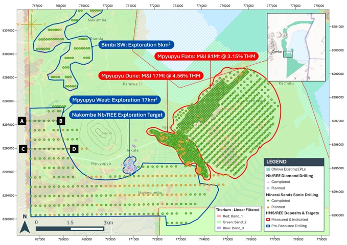
Figure 1: Mpyupyu West Phase I reconnaissance sonic drill plan, showing holes completed to 06 October 2026 and planned collar locations on the nominal 400 mN x 200 mE grid. The Mpyupyu West and Mpyupyu Resource outlines are also shown. Coordinates in WGS84 / UTM
| www.chilwaminerals.com.au | Page 3 of 18 |
| 9 October 2026| ASX Announcement | |
| Mpyupyu West HMS Resource Drilling Update |
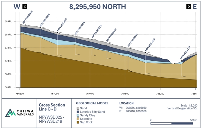
Figure 3:Cross section C-D - Representative W–E geological cross sections through the Mpyupyu West drilling at 8,295,950 mN (30x vertical exaggeration) and 8,297,150 mN (20x vertical exaggeration), showing the interpreted sequence of sand, lateritic silty sand), sandy clay), saprolite and saprock). Drill hole traces are shown with depths in metres. Sections show geological interpretation only.
| www.chilwaminerals.com.au | Page 4 of 18 |
| 9 October 2026| ASX Announcement | |
| Mpyupyu West HMS Resource Drilling Update |
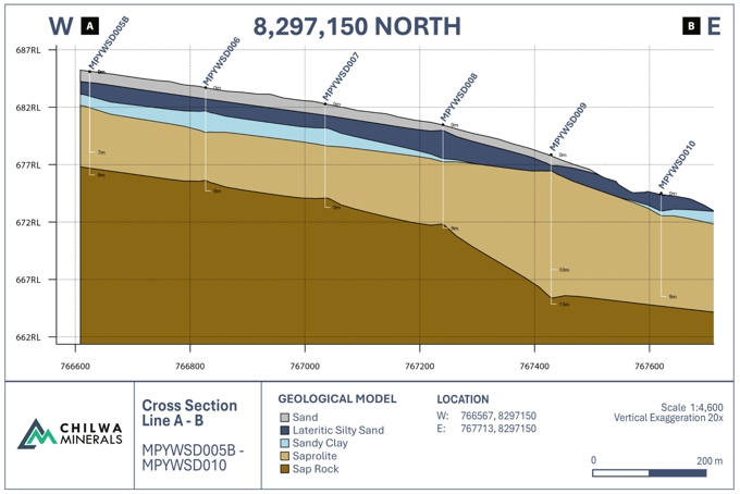
Figure 3:Cross section A-B - Representative W–E geological cross sections through the Mpyupyu West drilling at 8,295,950 mN (30x vertical exaggeration) and 8,297,150 mN (20x vertical exaggeration), showing the interpreted sequence of sand, lateritic silty sand), sandy clay), saprolite and saprock). Drill hole traces are shown with depths in metres. Sections show geological interpretation only.
Mpyupyu West is located on the western and southern flanks of the prominent Mpyupyu Hill, immediately west of the Mpyupyu Dune and Flat deposits. Sonic drilling on a nominal 400 mN x 200 mE grid has to date completed 218 holes for 2,292 metres, at an average hole depth of 8.6 metres. Drilling has consistently intersected the same sequence of silty sand, lateritic silty sand and sandy clay, overlying a free-dig, highly weathered saprolite unit. Holes routinely terminate at saprock, a harder, rockier unit that is not amenable to conventional mineral sands mining and processing and marks the base of the profile being drilled.
Review of the drill sections to date shows the stratigraphy to be consistent along and between sections. The reviews also indicate that some holes were terminated due to bit refusal before reaching saprock, and that the profile is deeper in the holes south of the Nakombe River. Hole depths will be reviewed as geological modelling progresses.
The target also surrounds the Nakombe Exploration Target where three diamond rigs continue to develop the prospect from the Exploration Target announced in June this year3.
| 3 | Refer ASX announcement 15 June 2026, “Maiden Niobium REE Exploration Target at Nakombe South”. |
| www.chilwaminerals.com.au | Page 5 of 18 |
| 9 October 2026| ASX Announcement | |
| Mpyupyu West HMS Resource Drilling Update |
Under the Company’s HMS sonic drilling standard operating procedure, all samples are panned and logged on site as drilling proceeds, providing consistent host-material descriptions for geological modelling.
Recorded observations include lithology, colour, washability, slimes content, grainsize and sorting, together with a visual estimate of heavy-mineral content used for logging and domaining purposes only. All core intervals are sub-sampled into standard chip trays for review by senior geologists, and geological modelling is being carried out concurrently with drilling so that a Phase II resource-definition grid can be designed on completion of the reconnaissance programme.
Portable XRF (pXRF) analysis has to date been completed on core at 0.5 metre intervals for 210 holes and is used to guide geological domaining and the selection of composite samples. No pXRF results are reported in this announcement. Total heavy mineral content will be determined by laboratory sink-float assay.
UPCOMING PROGRAMME
| ● | Phase I reconnaissance drilling at Mpyupyu West will continue with both sonic rigs on the nominal 400 mN x 200 mE grid, at a current rate of approximately eight holes per day, with completion of the 272-hole programme expected in mid-October 2026. |
| ● | Geological logging, on-site panning and pXRF domaining will continue in parallel with drilling, with wireframing of the mineralised saprolite horizon updated progressively so that a Phase II resource-definition grid at a nominal 100 mN x 100 mE spacing can be designed on completion of Phase I. |
| ● | Geological domain composites will be submitted for laboratory sink-float assay to determine total heavy mineral content, and for QEMSCAN analysis to characterise the mineral assemblage. Assay batch preparation and sample export permitting are underway. |
| ● | Bulk density studies will be undertaken on the saprolite horizon to support future volume-to-tonnage conversion. |
| ● | The Scoping Study covering the HMS deposits on the southern, western and northern shores of Lake Chilwa is advancing, underpinned by the upgraded Mpyupyu Mineral Resource (109.6 Mt, announced 19 June 2026) together with the Mposa deposit and all further Indicated and higher-category resources on the licence; the Study is expected in the fourth quarter of 2026. |
ABOUT CHILWA MINERALS
Chilwa Minerals Limited (ASX: CHW) is a Southern Malawi-focused critical minerals explorer advancing four concurrent programmes within its Lake Chilwa licence: a niobium-REE-tantalum-gallium discovery at the Nakombe alkaline intrusive target, and across the broader licence package, a Heavy Mineral Sands project along the northern and western shores of Lake Chilwa, and an emerging ionic clay REE programme targeting leachable rare earth elements within the weathering profile of the Chilwa Alkaline Complex. The Company is uniquely positioned with multiple critical mineral exposures within a single contiguous licence area in one of Africa’s most prospective underexplored alkaline provinces.
| www.chilwaminerals.com.au | Page 6 of 18 |
| 9 October 2026| ASX Announcement | |
| Mpyupyu West HMS Resource Drilling Update |
Nakombe Niobium-REE Discovery — an alkaline syenite intrusion hosting significant niobium mineralisation with co-product tantalum and gallium, for which a maiden conceptual Exploration Target of 34.1 to 51.2 million tonnes, covering a high-grade niobium porphyry core and a broader REE-enriched syenite domain, was announced to the ASX on 15 June 2026. Pre-resource diamond drilling is ongoing with two rigs, targeting geometry and grade continuity ahead of a potential maiden Resource Estimate. QEMSCAN and metallurgical test work are planned following completion of drilling. The Nakombe target is an exploration target that is conceptual in nature; there has been insufficient exploration to estimate a Mineral Resource, and it is uncertain whether further exploration will result in the estimation of a Mineral Resource.
Carbonatite-hosted REE Exploration — systematic exploration across a package of 47 geophysics anomalies identified in 2024 within the Chilwa Alkaline Province, one of the largest alkaline igneous provinces in sub-Saharan Africa, targeting carbonatite and alkaline syenite-hosted rare earth element mineralisation across multiple ranked targets within the licence.
Chilwa Heavy Mineral Sands (HMS) — a JORC 2012-compliant Mineral Resource covering the Mposa, Mpyupyu Dune and Mpyupyu Flat deposits on the northern shore of Lake Chilwa was announced on 7 December 2025. A revised Mineral Resource Estimate for the Mpyupyu deposits was announced on the ASX on 19 June 2026 with total resources at a 1% THM cut-off more than doubled to 109.6 Mt.
Ionic Clay REE Programme — an early-stage programme targeting leachable rare earth elements adsorbed onto clay minerals within the weathering profile developed over REE-bearing alkaline and carbonatite source rocks of the Chilwa Alkaline Complex. The ionic clay REE style of mineralisation — characterised by low-cost extractability using mild ammonium sulfate leaching without the need for energy-intensive processing — represents a potentially significant additional value driver within the Company’s existing licence footprint.
COMPLIANCE STATEMENT
No drilling Exploration Results are reported in this announcement. The information in this announcement relates to the progress of an exploration drilling programme, to geological observations made during that programme. No assay results, heavy mineral grades, drill hole intersections or estimates of quantity or grade of mineralisation are reported. Visual estimates of heavy-mineral content recorded during on-site panning and logging, and portable XRF measurements taken on core, are used for geological domaining and programme planning only; they are not a measure of total heavy mineral content and are not reported in this announcement as they are not considered Exploration Results.
The information in this announcement that relates to the Mpyupyu Mineral Resource Estimate was first reported by the Company in its ASX announcement dated 19 June 2026, “Mpyupyu Resource More Than Doubles to 109.6 Mt”. The Company confirms that it is not aware of any new information or data that materially affects the information included in that announcement, and that all material assumptions and technical parameters underpinning the estimate continue to apply and have not materially changed.
| www.chilwaminerals.com.au | Page 7 of 18 |
| 9 October 2026| ASX Announcement | |
| Mpyupyu West HMS Resource Drilling Update |
Competent Person Statement
The exploration results in this report is based on, and fairly represents, information and supporting documentation prepared by Mr Bertus Cilliers. Mr Cilliers has sufficient experience relevant to the style of mineralisation and type of deposit under consideration to qualify as a Competent Person as defined in the 2012 Edition of the ‘Australasian Code for Reporting of Exploration Results, Mineral Resources and Ore Reserves’. Mr Cilliers confirms there is no potential for a conflict of interest in acting as a Competent Person and has provided prior written consent to the inclusion in the report of the matters based on his information in the form and context in which it appears.
FORWARD-LOOKING STATEMENTS
This announcement may contain some references to forecasts, estimates, assumptions and other forward-looking statements. Although Chilwa believes that its expectations, estimates and forecast outcomes are based on reasonable assumptions, it can give no assurance that they will be achieved where matters lay beyond the control of Chilwa and its Officers. Forward-looking statements may be affected by a variety of variables and changes in underlying assumptions that are subject to risk factors associated with the nature of the business, which could cause actual results to differ materially from those expressed herein.
STANDARD FOR ASSESSING MINERAL RESOURCES
It is a requirement of the ASX Listing Rules that the reporting of mineral resources and ore reserves in Australia comply with the JORC Code. Investors outside Australia should note that, while mineral resource and any ore reserve estimates of the Company in this announcement comply with the JORC Code, they do not comply with the relevant guidelines in other countries and, in particular, do not comply with Item 1300 of Regulation S-K, which governs disclosure of mineral resources and reserves in registration statements filed with the US Securities and Exchange Commission (the “SEC Mining Disclosure Rules”). Estimates under JORC are not directly comparable to disclosure prepared under the SEC Mining Disclosure Rules. Such estimates under JORC do not form a part of any of our filings with the SEC. You should not assume that quantities reported as “resources” in this announcement will be converted to reserves under the JORC Code or the SEC Mining Disclosure Rules or that we will be able to legally and economically extract them.
-ENDS-
This Announcement has been authorised by the Managing Director.
For further information contact:
Cadell Buss
Founder and Managing Director
cbuss@chilwaminerals.com.au
| www.chilwaminerals.com.au | Page 8 of 18 |
| 9 October 2026| ASX Announcement | |
| Mpyupyu West HMS Resource Drilling Update |
JORC 2012 Mineral Resource Estimate
A Mineral Resource Estimate (MRE) for the Project has been classified and reported in accordance with the JORC code (2012 Edition). The Mineral Resource Estimate has been classified as Measured, Indicated and Inferred and at a 1.0 % THM cut-off contains 5.91 Mt of THM. The MRE is allocated across the Project deposits in JORC Table A below.
Table 2 Mineral Resources at 1.0% THM cut-off (Mpyupyu deposits updated 19 June 2026; other deposits as previously reported)
| Deposit | Category | Vol (Mm³) | Tonnes (Mt) | THM % | HMC (Mt) | Ilm % | Zr % | Leuc % | Rut % | Gar % | Mon % | Slime % | Ovsz % | RD |
| Mposa (Main) | Measured | 12.5 | 21.3 | 4.4 | 0.95 | 3.00 | 0.39 | 0.40 | 0.04 | 0.12 | 0.02 | 19.9 | 15.9 | 1.70 |
| Mposa (Main) | Indicated | 1.8 | 3.1 | 2.8 | 0.09 | 1.85 | 0.26 | 0.25 | 0.02 | 0.08 | 0.01 | 31.2 | 14.0 | 1.70 |
| Mposa (North) | Indicated | 0.7 | 1.2 | 2.3 | 0.03 | 0.88 | 0.18 | 0.14 | 0.03 | 0.22 | 0.00 | 13.7 | 39.9 | 1.70 |
| Bimbi | Indicated | 3.0 | 5.1 | 4.55 | 0.23 | 3.85 | 0.25 | N/A | 0.11 | N/A | N/A | 22.4 | 18.0 | 1.70 |
| Inferred | 1.4 | 2.4 | 3.79 | 0.09 | 3.21 | 0.21 | N/A | 0.09 | N/A | N/A | 24.4 | 16.5 | 1.70 | |
| Bimbi NE | Inferred | 7.4 | 12.5 | 2.57 | 0.32 | 2.18 | 0.14 | N/A | 0.06 | N/A | N/A | 20.2 | 5.0 | 1.70 |
| Mpyupyu (Dune) | Measured | 7.5 | 12.8 | 5.0 | 0.64 | 4.36 | 0.18 | 0.03 | 0.01 | 0.16 | 0.01 | 35.0 | 6.4 | 1.70 |
| Indicated | 2.5 | 4.2 | 3.1 | 0.13 | 2.58 | 0.13 | 0.02 | 0.01 | 0.09 | 0.01 | 35.4 | 4.6 | 1.70 | |
| Inferred | 0.3 | 0.5 | 3.6 | 0.02 | 2.96 | 0.15 | 0.02 | 0.01 | 0.13 | 0.01 | 43.8 | 6.0 | 1.70 | |
| Mpyupyu (Flat) | Measured | 6.9 | 11.6 | 3.9 | 0.46 | 3.20 | 0.19 | 0.05 | 0.02 | 0.08 | 0.01 | 31.2 | 2.9 | 1.70 |
| Indicated | 40.8 | 69.4 | 3.0 | 2.10 | 2.50 | 0.15 | 0.03 | 0.02 | 0.07 | 0.01 | 31.9 | 3.4 | 1.70 | |
| Inferred | 6.5 | 11.1 | 2.3 | 0.25 | 1.90 | 0.11 | 0.03 | 0.01 | 0.05 | 0.01 | 32.8 | 3.5 | 1.70 | |
| Nkotamo | Indicated | 1.6 | 2.4 | 3.70 | 0.09 | 2.23 | 0.23 | N/A | 0.10 | N/A | N/A | 19.1 | 24.8 | 1.50 |
| Halala | Indicated | 5.8 | 8.7 | 3.79 | 0.33 | 2.28 | 0.19 | N/A | 0.09 | N/A | N/A | 9.0 | 3.0 | 1.50 |
| Beacon | Indicated | 0.7 | 1.0 | 2.63 | 0.03 | 1.82 | 0.16 | N/A | 0.08 | N/A | N/A | 10.5 | 10.9 | 1.50 |
| Namanja West | Indicated | 3.0 | 4.5 | 3.66 | 0.16 | 2.63 | 0.25 | N/A | 0.10 | N/A | N/A | 7.0 | 4.4 | 1.50 |
| Total | Measured | 26.9 | 45.8 | 4.48 | 2.0 | 3.43 | 0.28 | N/A | 0.03 | N/A | N/A | 27.0 | 9.9 | 1.70 |
| Total | Indicated | 59.8 | 99.5 | 3.19 | 3.2 | 2.51 | 0.17 | N/A | 0.04 | N/A | N/A | 27.7 | 5.6 | 1.66 |
| Total | Inferred | 15.6 | 26.5 | 2.58 | 0.7 | 2.17 | 0.13 | N/A | 0.04 | N/A | N/A | 26.3 | 5.4 | 1.70 |
| Grand Total | 102.4 | 171.8 | 3.44 | 5.91 | 2.70 | 0.19 | N/A | 0.03 | N/A | N/A | 27.3 | 6.7 | 1.68 | |
Note: The Mpyupyu rows above reflect the updated Mineral Resource Estimate announced 19 June 2026. Figures for all other deposits are unchanged from previously reported estimates.
Estimates of the Mineral Resource were prepared by Bernhard Siebrits (CP for Resource estimation) and Bertus Cilliers (CP for exploration).
| ● | In situ, dry metric tonnes have been reported using varying densities and slime cut-off per deposit. |
| ● | No slimes cut off was used in the estimation. |
| ● | Leucoxene, Garnet and Monazite have to date only been estimated for the Mposa deposit. |
| ● | Tonnages and grades have been rounded to reflect the relative uncertainty of the estimates and resultant confidence levels used to classify the estimates. As such, columns may not total. |
Estimates are classified as Measured, Indicated and Inferred according to JORC Code.
| www.chilwaminerals.com.au | Page 9 of 18 |
| 9 October 2026| ASX Announcement | |
| Mpyupyu West HMS Resource Drilling Update |
Appendix – JORC Table 1
Section 1 Sampling Techniques and Data
(Criteria in this section apply to all succeeding sections)
| Criteria | JORC Code explanation | Commentary |
| Sampling techniques |
Nature and quality of sampling (eg cut channels, random chips, or specific specialised industry standard measurement tools appropriate to the minerals under investigation, such as down hole gamma sondes, or handheld XRF instruments, etc). These examples should not be taken as limiting the broad meaning of sampling.
Include reference to measures taken to ensure sample representivity and the appropriate calibration of any measurement tools or systems used.
Aspects of the determination of mineralisation that are Material to the Public Report.
In cases where ‘industry standard’ work has been done this would be relatively simple (eg ‘reverse circulation drilling was used to obtain 1 m samples from which 3 kg was pulverised to produce a 30 g charge for fire assay’). In other cases, more explanation may be required, such as where there is coarse gold that has inherent sampling problems. Unusual commodities or mineralisation types (eg submarine nodules) may warrant disclosure of detailed information. |
Phase I reconnaissance sonic drilling was undertaken at the Mpyupyu West prospect on a nominal 400 mN x 200 mE grid over the interpreted target area. Sonic drilling recovers a continuous column of material from surface, which is extruded into plastic sleeves at the rig.
Under the Company’s HMS sonic drilling standard operating procedure, the full core column is laid out, geologically logged and panned on site by an experienced geologist as drilling proceeds. Panning produces a heavy-mineral concentrate from which a visual estimate of heavy-mineral content is recorded, together with lithology, colour, washability, slimes content, grainsize and sorting.
Drill samples have been submitted for lab assay and not reported in this announcement.
|
| Drilling techniques | Drill type (eg core, reverse circulation, open-hole hammer, rotary air blast, auger, Bangka, sonic, etc) and details (eg core diameter, triple or standard tube, depth of diamond tails, face-sampling bit or other type, whether core is oriented and if so, by what method, etc). |
Drilling was undertaken using two track-mounted sonic (vibratory) drill rigs. Holes are drilled vertically from surface and recover a continuous core column through the full weathering profile.
Holes are terminated on intersecting saprock, a rockier unit beneath the weathered saprolite that is not amenable to conventional mineral sands mining and processing.
No core orientation, downhole surveying or diamond drilling was undertaken. Hole depths are shallow and downhole deviation from vertical is considered immaterial. |
| www.chilwaminerals.com.au | Page 10 of 18 |
| 9 October 2026| ASX Announcement | |
| Mpyupyu West HMS Resource Drilling Update |
| Criteria | JORC Code explanation | Commentary |
| Drill sample recovery |
Method of recording and assessing core and chip sample recoveries and results assessed.
Measures taken to maximise sample recovery and ensure representative nature of the samples.
Whether a relationship exists between sample recovery and grade and whether sample bias may have occurred due to preferential loss/gain of fine/coarse material. |
Core recovery is monitored at the rig by comparing the length of recovered core against the drilled interval for each run, and is recorded on the drill log. Sonic drilling is an industry-standard technique for unconsolidated and weathered mineral sands material and generally achieves high recovery.
No relationship between sample recovery and grade has been assessed, as no grades are reported in this announcement. |
| Logging |
Whether core and chip samples have been geologically and geotechnically logged to a level of detail to support appropriate Mineral Resource estimation, mining studies and metallurgical studies.
Whether logging is qualitative or quantitative in nature. Core (or costean, channel, etc) photography.
The total length and percentage of the relevant intersections logged.
|
All core is geologically logged on site over its full length. Logging is both qualitative and quantitative and records lithology, colour, washability, slimes content, grainsize, sorting and a visual estimate of heavy-mineral content following on-site panning.
Core is sub-sampled into standard chip trays which are retained for review by senior geologists and for reference during geological modelling. Core photography and pan concentrate photography are undertaken where practicable.
One hundred per cent of the core drilled to date has been logged. Logging is sufficient to support geological domaining and wireframing of the mineralised horizon, and is not used to support any reported estimate of grade or tonnage. |
| Sub-sampling techniques and sample preparation |
If core, whether cut or sawn and whether quarter, half or all cores taken.
If non-core, whether riffled, tube sampled, rotary split, etc and whether sampled wet or dry.
For all sample types, the nature, quality and appropriateness of the sample preparation technique.
Quality control procedures adopted for all sub- sampling stages to maximise representivity of samples.
Measures taken to ensure that the sampling is representative of the in-situ material collected, including for instance results for field duplicate/second- half sampling.
Whether sample sizes are appropriate to the grain size of the material being sampled. |
Core is sub-sampled into chip trays at the rig for logging and reference purposes. No sub-samples have been submitted for laboratory analysis to date.
Composite samples will be selected on the basis of the geological domains defined during logging and wireframing, and submitted for laboratory sink-float assay, per-interval XRF and QEMSCAN analysis. Compositing protocols, sample preparation procedures and associated quality control measures will be reported at the time any assay results are reported.
No sample preparation, sizing, splitting or pulverising has been undertaken for the purposes of this announcement.
|
| www.chilwaminerals.com.au | Page 11 of 18 |
| 9 October 2026| ASX Announcement | |
| Mpyupyu West HMS Resource Drilling Update |
| Criteria | JORC Code explanation | Commentary |
| Quality of assay data and laboratory tests |
The nature, quality and appropriateness of the assaying and laboratory procedures used and whether the technique is considered partial or total.
For geophysical tools, spectrometers, handheld XRF instruments, etc, the parameters used in determining the analysis include instrument make and model, reading times, calibrations factors applied and their derivation, etc.
Nature of quality control procedures adopted (eg standards, blanks, duplicates, external laboratory checks) and whether acceptable levels of accuracy (ie lack of bias) and precision have been established. |
No assay results are reported in this announcement and no laboratory analyses have been completed on the Phase I drilling.
Portable XRF (pXRF) readings are taken on core at 0.5 metre intervals as an indicative field tool to assist geological domaining and composite selection. No pXRF results are reported.
Total heavy mineral content will be determined by industry-standard laboratory sink-float assay on geological domain composites. Assay batch preparation and sample export permitting are underway.
|
| Verification of sampling and assaying |
The verification of significant intersections by either independent or alternative company personnel.
The use of twinned holes.
Documentation of primary data, data entry procedures, data verification, data storage (physical and electronic) protocols.
Discuss any adjustment to assay data.
|
Geological logging, on-site panning and pXRF domaining are undertaken by experienced geologists and reviewed by the Chief Project Geologist. Logging data is captured digitally at the rig and validated on import to the Company’s geological database.
Four twin holes were drilled during the reporting period by Sonic Rig 2 at locations where Sonic Rig 1 had been unable to penetrate to the basement formation, confirming the stratigraphic profile at those locations.
No assay data has been generated and accordingly no verification of assay data has been undertaken. No adjustment has been made to any primary data. |
| Location of data points |
Accuracy and quality of surveys used to locate drill holes (collar and down-hole surveys), trenches, mine
workings and other locations used in Mineral Resource estimation.
Specification of the grid system used.
Quality and adequacy of topographic control.
|
Drill collar locations are recorded using handheld GPS units with a typical horizontal accuracy of approximately ±3 to ±5 metres. The grid system used is WGS84 / UTM Zone 36S.
Collar elevations are derived from handheld GPS and regional digital elevation data. This level of location and topographic control is considered appropriate for a reconnaissance drilling programme in which no drilling Exploration Results are reported. Higher-precision collar and topographic survey will be undertaken prior to any Mineral Resource estimation. |
| www.chilwaminerals.com.au | Page 12 of 18 |
| 9 October 2026| ASX Announcement | |
| Mpyupyu West HMS Resource Drilling Update |
| Criteria | JORC Code explanation | Commentary |
| Data spacing and distribution |
Data spacing for reporting Exploration Results.
Whether the data spacing and distribution is sufficient to establish the degree of geological and grade continuity appropriate for the Mineral Resource and Ore Reserve estimation procedure(s) and classifications applied.
Whether sample compositing has been applied.
|
Phase I drilling is planned on a nominal 400 mN x 200 mE grid, comprising 272 drill holes. As at 06 October 2026, 218 holes had been completed for 2,992 metres, representing approximately 80% of the planned programme.
This spacing is a reconnaissance spacing designed to establish the extent and character of the mineralised saprolite horizon and will be infilled to establish geological and grade continuity appropriate for the estimation of a Mineral Resource under the JORC Code (2012 Edition).
A Phase II resource-definition programme at a nominal 100 mN x 100 mE spacing is planned following completion of Phase I. No sample compositing has been applied. |
| Orientation of data in relation to geological structure |
Whether the orientation of sampling achieves unbiased sampling of possible structures and the extent to which this is known, considering the deposit type.
If the relationship between the drilling orientation and the orientation of key mineralised structures is considered to have introduced a sampling bias, this should be assessed and reported if material. |
The mineralised saprolite horizon is developed from surface as a broadly flat-lying, laterally extensive blanket. Drill holes are vertical and are therefore oriented approximately perpendicular to the horizon.
No sampling bias arising from the orientation of drilling relative to geological structure is considered to have been introduced. No drilling Exploration Results are reported. |
| Sample security | The measures taken to ensure sample security. |
Core is retained in plastic sleeves and chip trays at the drill site and at the Company’s field facility, under the supervision of Company personnel at all times. No third-party handling has occurred.
Composite samples selected for laboratory analysis will be prepared, bagged, numbered and dispatched under the Company’s chain-of-custody procedures. Sample export permitting for laboratory dispatch is currently underway. Chain-of-custody and sample security arrangements will be reported at the time any assay results are reported. |
| www.chilwaminerals.com.au | Page 13 of 18 |
| 9 October 2026| ASX Announcement | |
| Mpyupyu West HMS Resource Drilling Update |
| Criteria | JORC Code explanation | Commentary |
| Audits or reviews | The results of any audits or reviews of sampling techniques and data. |
The Company implemented a new HMS sonic drilling standard operating procedure for this programme, under which all samples are panned and logged on site and core is sub-sampled into chip trays. Logging, panning and pXRF procedures are reviewed internally by the Chief Project Geologist.
Geological models are being built progressively as drilling advances so that data quality issues are identified during, rather than after, the programme.
No external audit or review of sampling techniques or data has been undertaken. As no assay data or grade estimates are reported in this announcement, no audit of assay data or grade estimation has been required. |
| www.chilwaminerals.com.au | Page 14 of 18 |
| 9 October 2026| ASX Announcement | |
| Mpyupyu West HMS Resource Drilling Update |
Section 2 Reporting Exploration Results
(Criteria listed in the preceding section also apply to this section.)
| Criteria | JORC Code explanation | Commentary |
| Mineral tenement and land tenure status |
Type, reference name/number, location and ownership including agreements or material issues with third parties such as joint ventures, partnerships, overriding royalties, native title interests, historical sites, wilderness or national park and environmental settings.
The security of the tenure held at the time of reporting along with any known impediments to obtaining a licence to operate in the area.
|
Work is undertaken under exploration licence EL0670/22/R1, which is 100% owned by Chilwa Minerals Africa Limited.
Chilwa Minerals Limited also controls 100% of licence EL0835/25, directly to the south of EL0670/22/R1, through its 100% owned subsidiary Phalombe Minerals.
EL0670/22/R1 and EL0835/25 were issued in September 2025 for 3 and 5 year exploration terms respectively. The licences currently extend to HMS and REE, and the Company has applied to extend the licences to niobium and related minerals. This is the usual practice in Malawi and the application is considered to be administrative. |
| Exploration done by other parties | Acknowledgment and appraisal of exploration by other parties. |
Academic research into the deposition of the HMS deposits around Lake Chilwa have been undertaken since the 1980’s.
Exploration of the HMS mineralisation in the lake Chilwa area has been undertaken by various government concerns and companies, commencing with Claus Brinkmann between 1991 and 1993 as part of an initiative by the German Government to aid mineral development in Malawi.
In 2014, Tate Minerals (Tate) undertook a desktop review of the work undertaken by Claus Brinkmann and entered into a Joint Venture agreement with Mota-Engil Investments (Malawi) Limited (MEIML) to explore EL 0572/20, an EL that contains the current target area. |
| www.chilwaminerals.com.au | Page 15 of 18 |
| 9 October 2026| ASX Announcement | |
| Mpyupyu West HMS Resource Drilling Update |
| Criteria | JORC Code explanation | Commentary |
| Geology | Deposit type, geological setting and style of mineralisation. |
The Mpyupyu West target is a heavy mineral sands prospect on the western flank of Mpyupyu Hill in the Lake Chilwa basin, Southern Malawi, immediately west of the Company’s Mpyupyu Dune and Flat deposits.
Phase I reconnaissance sonic drilling through the full weathering profile indicates that mineralisation is hosted in-situ within a deeply weathered saprolite blanket developed over the underlying basement, similar in deposit style to the Kasiya rutile project in central Malawi. In this style, chemically resistant heavy minerals are residually concentrated in place as less stable minerals break down to clay under deep tropical weathering. |
|
Drilling has intersected a consistent sequence of sand, silty sand, sandy clay and free-dig, highly weathered saprolite, with holes terminating on saprock. The mineralised horizon is developed from surface beneath a thin sand cover, averages 7.3 metres in thickness across the holes drilled to date and reaches a maximum of 12 metres. | ||
| Drill hole Information |
A summary of all information material to the understanding of the exploration results including a tabulation of the following information for all Material drill holes:
● easting and northing of the drill hole collar ● elevation or RL (Reduced Level – elevation above sea level in metres) of the drill hole collar ● dip and azimuth of the hole ● downhole length and interception depth ● hole length.
If the exclusion of this information is justified on the basis that the information is not Material and this
exclusion does not detract from the understanding of the report, the Competent Person should clearly explain why this is the case. |
No drilling Exploration Results are reported in this announcement and accordingly no drill hole information is tabulated.
As at 06 October 2026, 218 drill holes had been completed at the Mpyupyu West prospect for 2,992 metres, of a planned Phase I programme of 272 holes. Completed and planned collar locations are shown in Figure 1.
Drill hole collar coordinates, depths, orientations and intersections will be reported at the time any Exploration Results are reported.
|
| Data aggregation methods |
In reporting Exploration Results, weighting averaging techniques, maximum and/or minimum grade truncations (eg cutting of high grades) and cut-off grades are usually Material and should be stated.
Where aggregate intercepts incorporate short lengths of high-grade results and longer lengths of low grade results, the procedure used for such aggregation should be stated and some typical examples of such aggregations should be shown in detail.
The assumptions used for any reporting of metal equivalent values should be clearly stated. |
Not applicable to the drilling. No grades, intercepts or aggregated drilling results are reported in this announcement.
No cutting, capping, top-cutting, length-weighting or metal-equivalent reporting has been applied, as no grade data is reported.
|
| www.chilwaminerals.com.au | Page 16 of 18 |
| 9 October 2026| ASX Announcement | |
| Mpyupyu West HMS Resource Drilling Update |
| Criteria | JORC Code explanation | Commentary |
| Relationship between mineralisation widths and intercept lengths |
These relationships are particularly important in the reporting of Exploration Results.
If the geometry of the mineralisation with respect to the drill hole angle is known, its nature should be reported.
If it is not known and only the down hole lengths are reported, there should be a clear statement to this effect (eg ‘down hole length, true width not known’). |
Not applicable. No mineralised intercepts are reported.
The thickness figures quoted in this announcement describe the downhole thickness of a logged geological horizon, not a mineralised intercept defined by assay. The horizon is broadly flat-lying and drill holes are vertical, such that downhole thickness approximates true thickness.
|
| Diagrams | Appropriate maps and sections (with scales) and tabulations of intercepts should be included for any significant discovery being reported These should include, but not be limited to a plan view of drill hole collar locations and appropriate sectional views. |
Figure 1 shows the Phase I reconnaissance sonic drill plan at Mpyupyu West, including holes completed to 06 October 2026 and planned collar locations on the nominal 400 mN x 200 mE grid.
Figure 2 shows representative W–E geological cross sections through the Mpyupyu West drilling at 8,295,950 mN and 8,297,150 mN, showing the interpreted stratigraphic sequence.
No grade plans are presented, as no drilling Exploration Results are reported. No diagram presents an assayed grade. |
| Balanced reporting | Where comprehensive reporting of all Exploration Results is not practicable, representative reporting of both low and high grades and/or widths should be practiced to avoid misleading reporting of Exploration Results. |
This announcement reports the progress of an exploration drilling programme and geological observations made during that programme at the Mpyupyu West prospect.
Portable XRF readings taken on core, and visual heavy-mineral estimates recorded during on-site panning of sonic core, are expressly excluded from this announcement because they are not a measure of total heavy mineral content.
Progress figures for the Company’s wider drilling programme, including the Bimbi Main deposit at 62% complete, are disclosed so that the Mpyupyu West programme is presented in the context of the whole-of-programme position. |
| www.chilwaminerals.com.au | Page 17 of 18 |
| 9 October 2026| ASX Announcement | |
| Mpyupyu West HMS Resource Drilling Update |
| Criteria | JORC Code explanation | Commentary |
| Other substantive exploration data |
Other exploration data, if meaningful and material, should be reported including (but not limited to):
geological observations; geophysical survey results;
geochemical survey results; bulk samples – size and method of treatment; metallurgical test results; bulk density, groundwater, geotechnical and rock characteristics; potential deleterious or contaminating substances.
|
The Mpyupyu West programme has been informed by interpreted geophysical data over the Chilwa licence area, including interpreted thorium anomalies, and by the geological setting of the adjacent Mpyupyu Dune and Flat deposits.
Portable XRF analysis is being undertaken on core at 0.5 metre intervals for geological domaining purposes. QEMSCAN analysis of geological domain composites is planned to characterise the mineral assemblage, and bulk density studies are planned on the saprolite horizon. No results from any of this work are reported in this announcement.
No metallurgical testwork, groundwater, geotechnical or deleterious element data is reported for the Mpyupyu West prospect. |
| Further work |
The nature and scale of planned further work (eg tests for lateral extensions or depth extensions or large-scale step-out drilling).
Diagrams clearly highlighting the areas of possible extensions, including the main geological
interpretations and future drilling areas, provided this information is not commercially sensitive.
|
Phase I reconnaissance drilling will continue with both sonic rigs, with completion of the 272-hole programme expected in mid-October 2026. Planned collar locations are shown in Figure 1.
On completion of Phase I, a Phase II resource-definition programme at a nominal 100 mN x 100 mE spacing is planned, informed by the geological wireframes developed during Phase I.
Geological domain composites will be submitted for laboratory sink-float assay and QEMSCAN analysis, and bulk density studies will be undertaken on the saprolite horizon. Assay batch preparation and sample export permitting are underway.
Subject to grant of the adjoining exploration licence application to the west, extensional drilling is planned to test the continuation of the mineralised horizon beyond the current boundary of EL0670/22/R1. Near-surface sampling will also be extended, including 14 additional sample points designed on the lee side of the Mpyupyu dunes.
Resource-definition drilling at the Bimbi Main deposit will resume on completion of the Mpyupyu West Phase I programme.
Further reconnaissance hand panning may be undertaken to extend coverage west and south of the current sample grid as conditions allow. The hand-panning results will be verified by sonic drilling and standard HMS sink-float assay on the planned drill grid. |
| www.chilwaminerals.com.au | Page 18 of 18 |