| NI 43-101 Technical Report |  |
Rift Project - Nebraska, USA
NI 43-101 Technical Report on the
Rift Project
Johnson and Pawnee Counties, Nebraska, USA
| Prepared For: | APEX CRITICAL METALS CORP. |
| 1450 - 789 West Pender St | |
| Vancouver, BC | |
| Canada, V6C-1H2 |
Author: Robin J Wilson, B.Sc. (Hons) Geology, MAusIMM, MAIG
Effective Date: May 15, 2026
Signature Date: June 12, 2026
| NI 43-101 Technical Report | |
Table of Contents
| 1 Executive Summary | 2 |
| 1.1 Property Description | 2 |
| 1.2 Mineral Tenure | 2 |
| 1.3 Geology and Mineralization | 2 |
| 1.4 Exploration | 2 |
| 1.5 Mineral Resource & Mineral Reserve Estimates | 3 |
| 1.6 Development & Operations | 3 |
| 1.7 Conclusions & Recommendations | 3 |
| 1.8 Risks | 3 |
| 2 Introduction | 4 |
| 3 Reliance on Experts | 5 |
| 4 Property Description & Location | 6 |
| 4.1 Property Location | 6 |
| 4.2 Mineral Tenure | 6 |
| 4.3 Environmental Liabilities | 11 |
| 4.4 Required Permits | 12 |
| 4.5 Other Significant Factors or Risks | 12 |
| 5 Accessibility, Local Resources, Infrastructure, Physiography & Climate | 13 |
| 5.1 Physiography | 13 |
| 5.2 Climate | 13 |
| 5.3 Accessibility | 13 |
| 5.4 Local Resources & Infrastructure | 13 |
| 6 History | 15 |
| 6.1 Previous Exploration & Development | 15 |
| 6.2 Prior Ownership | 19 |
| 6.3 Historical Mineral and Resource Estimates | 19 |
| 6.4 Historical Production | 20 |
| 7 Geological Setting & Mineralization | 21 |
Rift Project - Nebraska, USA
| 7.1 Regional Geology | 21 |
| 7.2 Property Geology | 22 |
| 7.3 Mineralization | 24 |
| 8 Deposit Type | 25 |
| 9 Exploration | 27 |
| 9.1 Results | 28 |
| 10 Drilling | 30 |
| 10.1 2026 Drill Results | 33 |
| 10.1.1 RIFT26-001A | 33 |
| 10.1.2 RIFT26-002 | 34 |
| 10.1.3 RIFT26-003 | 34 |
| 10.1.4 RIFT26-004 | 35 |
| 10.1.5 RIFT26-005A | 35 |
| 10.1.6 RIFT26-006 | 35 |
| 11 Sample Preparation, Analysis & Security | 38 |
| 11.1 Pre-Analysis Sample Preparation and Quality Control | 38 |
| 11.1.1 MolyCorp Drill Programs (1976-1986) | 38 |
| 11.1.2 NioCorp Resample Program (2010) | 38 |
| 11.1.3 Apex Resample Program (2025): | 38 |
| 11.1.4 Drill Programs (2011 & 2026) | 38 |
| 11.2 Laboratory Sample Preparation & Analysis | 40 |
| 11.3 Quality Control & Quality Assurance | 41 |
| 11.3.1 2010 NioCorp Historical Re-Assay and 2011 Drill Program | 42 |
| 11.3.2 2025 Apex Historical Re-Assay Program | 42 |
| 11.3.3 2026 Drill Program - Blanks | 43 |
| 11.3.4 2026 Drill Program - Certified Reference Materials | 44 |
| 11.3.1 Qualified Person Opinion | 46 |
| 12 Data Verification | 47 |
| 12.1 Verification Results | 48 |
| 12.2 Qualified Person Opinion | 50 |
| 13 Mineral Processing & Metallurgical Testing | 51 |
| 14 Mineral Resource Estimate | 52 |
| 15 Item 15 to 22 Not Applicable (Early-Stage Property) | 53 |
| 23 Adjacent Properties | 54 |
| 24 Other Relevant Data & Information | 56 |
| NI 43-101 Technical Report | |
| 25 Interpretation & Conclusions | 57 |
| 26 Recommendations | 58 |
| 27 References | 60 |
| 28 Date & Signature Page | 62 |
| 29 Certificate of Qualified Person | 63 |
List of Tables
| Table 4-1 Rift Rare Earth Project Mineral Tenure List | 8 |
| Table 6-1 Historical Drillhole Campaign Summary | 16 |
| Table 6-2 Summary of Significant REO and Nb2O5 intercepts in Historical Drill Holes located within Rift Rare Earth Project | 17 |
| Table 7-1 Historical Molycorp Lithologic Nomenclature and Corresponding Current Lithologic Units | 23 |
| Table 9-1 Summary 2025 Re-logged and Re-assayed Drillholes | 27 |
| Table 10-1 2026 Drillhole Locations and Attributes | 31 |
| Table 10-2 Summary of Significant Results from Trinity Zone - 2026 Drill Program | 36 |
| Table 10-3 Summary of Significant Results from Neo Zone - 2026 Drill Program | 36 |
| Table 11-1 Summary of Laboratory Methods | 40 |
| Table 11-2 Summary of Sample and Control Submissions | 41 |
| Table 11-3 2026 Drill Program - Silica Blank Statistics | 43 |
| Table 11-4 2026 Drill Program - GRE-11 | 44 |
| Table 11-5 2026 Drill Program - OREAS 460b | 45 |
| Table 11-6 2026 Drill Program - OREAS 464b | 45 |
| Table 12-1 Summary of QP selected samples | 47 |
| Table 26-1 Estimated Budget for Proposed Work | 58 |
List of Figures
| Figure 4-1 Rift Rare Earth Project Location Map | 6 |
| Figure 4-2 Rift Rare Earth Project Mineral Tenure Map | 8 |
| Figure 5-1 Rift Rare Earth Project Access Map | 14 |
| Figure 6-1 Comparison of the 1970 Magnetic and Gravity Geophysical Surveys (Tetra Tech, 2012) | 15 |
| Figure 6-2 Historical Exploration Map | 19 |
| Figure 7-1 Regional Geology | 22 |
| Figure 9-1 Exploration Map | 28 |
| Figure 9-2 Mean difference % (REO- LnO) / REO - by hole | 29 |
| Figure 10-1 Drillhole Location Map | 31 |
Rift Project - Nebraska, USA
| Figure 10-2 Drilling in progress at Rift Rare Earth Project - RIFT26-006 and RIFT26-005A | 33 |
| Figure 10-3 2026 Drilling - Assay Results (REO %) | 37 |
| Figure 11-1 Core logging facility at Rift Rare Earth Project | 39 |
| Figure 12-1 Samples selected for verification sampling | 48 |
| Figure 12-2 QP Verification Samples - Relative Percent Difference vs Average REO Value | 49 |
| Figure 12-3 QP Verification vs Original Sample Results | 50 |
| Figure 23-1 Adjacent Property Map | 55 |
|
Abbreviations
| Abbreviation | Definition | Abbreviation | Definition | |
| °C | Degrees Celsius | NDEE | Nebraska Department of Environment and Energy | |
| ATV | Acoustic Televiewer | NdPr | NEODYMIUM-PRASEODYMIUM DISTRIBUTION CALCULATED AS (ND2O3 + PR2O3) / REO X 100 | |
| BC | British Columbia | NSR | Net Smelter Return | |
| BQ | BQ-size diamond drill core | ON | Ontario | |
| CDS | Conservation and Survey Division | OTP | Option to Purchase | |
| Ce | Cerium | OTV | Optical Televiewer | |
| CRM | Certified Reference Material | ppm | Parts Per Million | |
| DGPS | Differential Global Positioning System | Pr | Praseodymium | |
| Dy | Dysprosium | QA/QC | Quality Assurance / Quality Control | |
| Eu | Europium | QP | Qualified Person | |
| Gd | Gadolinium | REE | Rare Earth Elements | |
| GPS | Global Positioning System | REO | RARE EARTH OXIDES - SUM OF CE2O3, LA2O3, PR2O3, ND2O3, EU2O3, SM2O3, GD2O3, TB2O3, DY2O3, HO2O3, ER2O3, TM2O3, YB2O3, LU2O3, AND Y2O3. | |
| Ho | Holmium | RQD | Rock Quality Designation | |
| HQ | HQ-size diamond drill core | SG | Specific Gravity | |
| ICP-MS | Inductively Coupled Plasma - Mass Spectrometry | Sm | Samarium | |
| ICP-OES | Inductively Coupled Plasma - Optical Emission Spectrometry | Tb | Terbium | |
| ISE | Ion Selective Electrode | Tm | Thulium | |
| km | Kilometre | UNL | University of Nebraska-Lincoln | |
| La | Lanthanum | USBM | United States Bureau of Mines | |
| LREE | Light Rare Earth Elements | USGS | United States Geological Survey | |
| Lu | Lutetium | XRD | X-Ray Diffraction | |
| m | Metre | XRF | X-Ray Fluorescence | |
| masl | Metres Above Sea Level | Yb | Ytterbium | |
| Nb | Niobium | |||
| Nb₂O₅ | Niobium Pentoxide | |||
| Nd | Neodymium |
| NI 43-101 Technical Report | |
1 Executive Summary
Apex Critical Metals Corp. ("Apex") has retained Robin J. Wilson, a consulting geologist for Orex Pty Ltd. to prepare an independent Technical Report on the Rift Project (the "Property" or "Rift Project"), located in Nebraska, USA. This report (the "Technical Report") has been prepared in compliance with regulatory disclosure and reporting requirements as outlined in Canadian National Instrument 43-101 - Standards of Disclosure for Mineral Projects ("NI 43-101"), companion policy NI 43-101CP and Form 43-101F1 - Technical Report. This report summarizes known geology, mineralization, historical exploration and recent work completed by Apex on the Property and provides interpretations of the exploration results and recommendations for future exploration work.
1.1 Property Description
The Property is located in the southeastern portion of the State of Nebraska, in the Johnson and Pawnee Counties. It is approximately 75 km southeast of Lincoln (capital of Nebraska) and 110 km south of Omaha, Nebraska. It is also adjacent to the mineral property held by NioCorp Developments Ltd. ("NioCorp") known as the Elk Creek Project (for more information please see Section 23: Adjacent Properties).
1.2 Mineral Tenure
The Rift Project comprises thirty-one (31) Exploration Lease Agreements and Options to Purchase entered into by Apex as of May 1, 2026 (the "Agreements"), covering approximately 3,957.50 acres located in Johnson and Pawnee Counties, Nebraska. The Agreements are held by Apex's wholly owned subsidiary Elk Creek Rare Earths Corp. and provide Apex with the exclusive right to explore the Property and the option to acquire the underlying mineral interests from the private landowners. The Agreements have a defined 60-month term and, upon exercise, the mineral interests will be subject to an aggregate 2.5% net smelter return royalty, with Apex retaining rights to repurchase a portion of the royalty as described in Section 4.2.
1.3 Geology and Mineralization
The Property is underlain by the Elk Creek carbonatite complex, an elliptical carbonatite and associated mafic intrusive rocks emplaced into older Precambrian basement rocks and overlain by approximately 200 m of flat-lying Pennsylvanian marine sediments. The complex consists predominantly of dolomite, calcite, and ankerite carbonatite with lesser chlorite, barite, apatite, phlogopite, pyrochlore, serpentine, fluorite, sulphides, and quartz. REE mineralization is principally associated with barite-bearing beforsite and related carbonatite units and is hosted by bastnasite, parisite, synchysite, and monazite. Niobium mineralization is primarily associated with pyrochlore-bearing and magnetite-bearing dolomite carbonatite. Recent drilling has identified broad intervals of REE mineralization associated with carbonatite and hematite-altered dolomite carbonatite, including the near-surface Trinity Zone and the deeper NdPr-enriched Neo Zone.
1.4 Exploration
Exploration in the project area began with regional geophysical surveys in the 1960s and 1970s that outlined the Elk Creek gravity and magnetic anomaly and led to the discovery of the Elk Creek carbonatite. Historical work by Cominco American Inc. ("Cominco"), Molycorp Inc. ("Molycorp"), and NioCorp (formerly called Quantum Rare Earth Developments Corp.) included drilling, geophysical surveys, and resampling of historical material, with several historical drillholes within the current Property returning significant REE and niobium intercepts. In 2025, Apex completed a relogging and resampling program on selected historical Molycorp drill core to establish a modern analytical baseline and support geological modelling. In 2026, Apex commenced an initial diamond drilling program to confirm and expand historical mineralization, evaluate continuity along strike and down dip, and improve understanding of the geometry and structural controls of REE mineralization. Assay results received to date confirm broad Trinity Zone REE mineralization and the presence of a deeper NdPr-enriched Neo Zone.
|
1.5 Mineral Resource & Mineral Reserve Estimates
No Mineral Resource Estimate has been completed on the Property.
1.6 Development & Operations
There are no development activities or mining operations on the Property.
1.7 Conclusions & Recommendations
The Rift Project is an early-stage exploration property underlain by the Elk Creek carbonatite complex in Johnson and Pawnee Counties, Nebraska, and is consistent with a carbonatite-hosted REE deposit model. Historical drilling by Molycorp, Cominco, and NioCorp confirmed significant REE and niobium mineralization within the Property, with key intercepts including 155.5 m at 2.70% REO (EC-093) and 236.2 m at 2.10% REO (NEC11-004).
The 2026 diamond drill program has confirmed and expanded upon these results, intersecting significant REE mineralization in all six reported drillholes. Drilling has defined a near-surface high-grade horizon (the "Trinity Zone"), with best intercepts of 137.2 m at 2.01% REO (RIFT26-005A) and 80.0 m at 2.29% REO (RIFT26-003), as well as a deeper NdPr-enriched horizon (the "Neo Zone") with NdPr distributions of 31-52%. Both zones remain open along strike and at depth.
The Author has concluded that, based on available information, the Property warrants further exploration by Apex, and recommends a Phase II exploration to advance the Property toward an initial NI 43-101 Mineral Resource Estimate, including approximately 10,000 to 12,000 m of infill and step-out diamond drilling targeting the Trinity and Neo Zones, refinement of geological and mineralization models, and preliminary metallurgical characterization of representative composites from both zones. The estimated budget for Phase II is approximately USD $5,845,000. Advancement to resource estimation is contingent on positive drilling and metallurgical results.
1.8 Risks
Key risks include the early-stage nature of the Property, pending assay results from the 2026 program, the need for additional drilling, uncertainty regarding metallurgical recovery, and the absence of resource, mining, processing, environmental, and economic studies. Continued phased exploration is recommended, with further advancement dependent on positive drilling, metallurgical, and geological results. As with all early-stage exploration projects, there is no assurance that ongoing or future exploration activities will result in the discovery or delineation of an economically viable mineral deposit. Risks can somewhat be mitigated by adhering to a multi-phase exploration program as outlined in Section 1.7.
| NI 43-101 Technical Report | |
2 Introduction
Apex Critical Metals Corp. ("Apex") has retained Robin J. Wilson, a consulting geologist for Orex Pty Ltd., to prepare an independent Technical Report on the Rift Project (the "Property"), located in Nebraska, USA. The Property consists of thirty-one (31) Exploration Lease Agreements and Option to Purchase Agreements (the "OTPs") covering 3,957.50 acres.
Apex, via its local agent Key Landmark, LLC, initially acquired the rights to explore and options to purchase the Property in September 2025. The rights to explore and option to purchase the mineral interest in the Property were acquired for an aggregate purchase price of USD $791,500, equaling USD $200 per acre. For 29 out of the 31 OTPs (covering 3,565.29 acres), the option purchase price is USD $10,000 per acre, with 50% of the purchase price payable at closing and the remaining 50% due within three years of closing. The remaining two Agreements, covering 363.92 mineral acres in Pawnee County held by GWB LLC., carry a purchase price of USD $20,000 per acre, payable in full at closing. If the option to is exercised by Apex, an aggregate of 2.5% net smelter return ("NSR") royalty is payable, with Apex retaining the right to repurchase 0.25% of the NSR royalty for US$500,000. Further agreements have been signed since September 2025 with the landholding expanding to its current 3,957.50 acres (as of the Effective Date).
This Technical Report has been prepared in compliance with regulatory disclosure and reporting requirements as outlined in NI 43-101, companion policy NI 43-101CP and Form 43-101F1 - Technical Report. The Qualified Person responsible for this report is Robin J. Wilson B.Sc. (Hons) Geology, MAusIMM MAIG.
The purpose of this Technical Report is to review historical data as well as the results of recent exploration conducted by the Apex, including the relogging and resampling program and current 2026 drill program on the Property, and provide recommendations for future work.
Information, conclusions, and recommendations contained within this Technical Report are based on field observations, as well as published and unpublished data (for more information please see Section 27: References) available to the Author at the time of preparing this Technical Report.
The Author, Robin J. Wilson, conducted a personal inspection of the Rift Project on 6 March 2026 for a duration of one day. During the personal inspection, the Author reviewed the current on-going drill program and conducted independent sampling of select drill holes (RIFT26-001A and RIFT26-002) from the 2026 drill program, along with verification of drill hole location and orientation, access assessment and a review of core processing procedures including geological logging, basic RQD, core sampling, core photography and specific gravity collection, and other exploration procedures for the current program. The Author has not been involved in any prior exploration work on the Property.
|
3 Reliance on Experts
For the purposes of this report, the Author has relied on ownership information provided by Apex concerning legal matters which are discussed in Section 4.2 of this Report. Specifically, the Author received copies of all Agreements pertaining to the Property entered into by Apex as of May 1, 2026. The Author has relied on these Agreements with respect to the description of the Property's land position, leasehold interests, and option rights.
Land holding information in the Agreements was verified by the Author against the online land assessment websites for both Pawnee and Johnson County (https://pawnee.gworks.com/ and https://johnson.gworks.com/ ) as of the Effective Date.
While title and ownership information were reviewed for the purposes of this Technical Report, the Author has not independently verified legal title to the Property, and this review does not constitute, nor is it intended to represent, a legal opinion regarding title, ownership, validity of agreements, encumbrances, or any other legal matter affecting the Property.
| NI 43-101 Technical Report | |
4 Property Description & Location
4.1 Property Location
The Project is located in the southeastern portion of the State of Nebraska, in the Johnson and Pawnee Counties. It is approximately 75 km southeast of Lincoln (state capital of Nebraska) and 110 km south of Omaha, Nebraska. The Project is easily accessible by road from both Omaha and Lincoln.
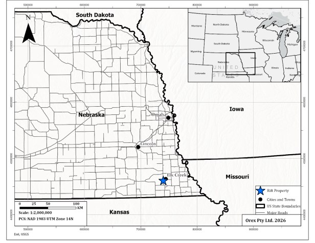
Figure 4-1 Rift Rare Earth Project Location Map
4.2 Mineral Tenure
The Rift Project comprises thirty-one (31) Exploration Lease Agreements and Options to Purchase (the "Agreements"), covering approximately 3,957.50 acres located in Johnson and Pawnee Counties, Nebraska.
The Agreements provide Apex with the exclusive right to explore the subject lands and the option to acquire the underlying mineral interests from the private landowners. The Agreements are all substantially similar in form and substance, and were negotiated on an individual basis with landowners.
The Agreements were initially entered into on behalf of Apex by Key Landmark, LLC, an independent land services provider retained by Apex to identify mineral and surface ownership, negotiate terms, and secure agreements with landowners as the agent of Apex. Under the terms of this arrangement, Agreements were initially taken in the name of Key Landmark, LLC, and following execution, payment, and recording of a memorandum of agreement at the applicable county office, were assigned to Elk Creek Rare Earths Corp., Apex's wholly owned subsidiary.
| Rift Project - Nebraska, USA |
An aggregate of USD $791,500, equaling USD $200 per acre, has been paid to date to secure the exploration and option rights under the Agreements. In addition to the payment required to secure the option to purchase agreements, a payment of USD $5,000 per drillhole to the surface landholders is required upon commencement of drilling, with select landholders also requiring a USD $1,500 surface damage deposit held in escrow per drillhole.
Each Agreement provides a defined term (60 months) during which Apex may conduct exploration activities and exercise its option to acquire the mineral interests. Apex may acquire the mineral interests by exercising its option to purchase at a price in accordance with the terms of the Agreements. For 29 out of the 31 Agreements (covering 3,565.29 acres), the option purchase price is USD $10,000 per mineral acre, with 50% of the purchase price payable at closing and the remaining 50% due within three years of closing. The remaining two Agreements, covering 363.92 mineral acres in Pawnee County held by GWB LLC., carry a purchase price of USD $20,000 per acre, payable in full at closing.
Upon exercise of the option, the mineral interests will be subject to an aggregate 2.5% net smelter return ("NSR") royalty. This comprises a 2.0% NSR royalty reserved to each respective landowner under the terms of the Agreements, and a 0.5% NSR royalty retained by Key Landmark LLC as consideration for its services in acquiring the Agreements. Apex retains the right to repurchase 50% of this NSR royalty (0.25%) for a payment of USD $2,500 per net mineral acre, which would reduce the total NSR royalty accordingly.
The Agreements have been recorded in the appropriate county offices, and copies of the executed Agreements and memoranda have been provided to Apex and the Qualified Person.
| NI 43-101 Technical Report | |
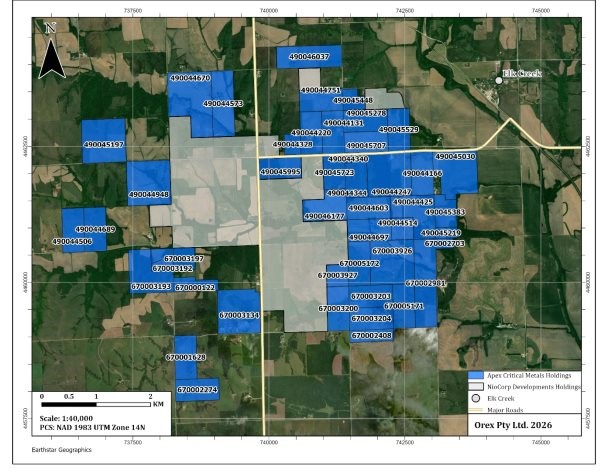
Figure 4-2 Rift Rare Earth Project Mineral Tenure Map
Table 4-1 Rift Rare Earth Project Mineral Tenure List
JOHNSON COUNTY, NEBRASKA (Township 4N - Range 11E)
| Parcel ID | Section | Legal Description | Landowner / Lessor |
Agreement Date |
Expiry Date |
Acres |
| 490044697 | 35 | S/2SW/4 | Arlin L. Beethe and Kimberly R. Beethe, husband and wife | 9/15/2025 | 9/15/2030 | 80.00 |
| 490044344; 490044340 | 35 | W/2NW/4 (mineral; excl. surface strip ~2.17 ac incl. ~1.04 ac former road ROW) | Arlin L. Beethe and Kimberly R. Beethe, husband and wife | 9/15/2025 | 9/15/2030 | 80.00 |
| Rift Project - Nebraska, USA |
| Parcel ID | Section | Legal Description | Landowner / Lessor |
Agreement Date |
Expiry Date |
Acres |
|
490044948 |
32 |
NE/4 |
Bryan J. Heidemann and Karly S. Heidemann, husband and wife |
7/23/2025 |
7/23/2030 |
160.00 |
|
490044425; 490045138; 490045219; 490045383 |
35, 36 |
E/2SE/4 and NW/4SE/4 Sec 35; Lots 1-4 NW/4SW/4; Lots 3-4 SW/4SW/4; Lot 1 SW/4SW/4SW/4; Lot 2 SE/4SW/4SW/4 Sec 36 |
Circle HL Farm, LLC |
6/1/2025 |
6/1/2030 |
195.00 |
|
490045278; 490045448 |
26 |
N/2SW/4 and SW/4NW/4 (excl. road strip - Lot 1 NW/4) |
Curtis T. Peters and Catherine M. Peters, husband and wife |
7/22/2025 |
7/22/2030 |
119.52 |
|
490044220; 490045723; 490045995 |
27, 34 |
W/2SE/4 Sec 27 (excl. ~2.04 ac road); N 62.84 ac of E/2NE/4 Sec 34 (excl. ~2.62 ac road); N/2NW/4 Sec 34 (excl. ~1.60 ac road + ~4.35 ac hwy easement) |
Kathleen D. Butler, Succ. Trustee, Eldon L. Buethe Trust (Jan 15 1993) |
9/24/2025 |
9/24/2030 |
216.58 |
|
490045529; 490044247 |
26, 35 |
W/2SE/4 Sec 26; E/2NW/4 and W/2NE/4 Sec 35 |
L&M Peters Farms, LLC (Lonny K. Peters, Manager) |
5/28/2025 |
5/28/2030 |
240.00 |
|
490044506; 490044689 |
31, 32 |
E/2SE/4 SEC 31; W/2SW/4 SEC 32 |
Lanie L. Heidemann, Trustee, Lanie L. Heidemann Living Trust (Jan 23 2013) |
5/20/2025 |
5/20/2030 |
160.00 |
|
490045197 |
29 |
SW/4 |
Lanie L. Heidemann, Trustee, Lanie L. Heidemann Living Trust (Jan 23 2013) |
5/20/2025 |
5/20/2030 |
160.00 |
|
490046037 |
22 |
S/2SE/4 and SE/4SW/4 |
Lavon L. Heidemann and Robin Y. Heidemann, husband and wife |
7/22/2025 |
7/22/2030 |
120.00 |
|
490045707 |
26 |
S/2SW/4 (excl. surface only - ~3.85 ac road strip) |
Nathan R. Bartels and Jolene K. Bartels, husband and wife |
7/23/2025 |
7/23/2030 |
80.00 |
|
490044131; 490044751 |
27 |
S/2NE/4 AND E/2SE/4 (EXCL. ~1.65 ac road strip) |
Sheila Peters, a single person |
7/22/2025 |
7/22/2030 |
158.35 |
| NI 43-101 Technical Report | |
| Parcel ID | Section | Legal Description | Landowner / Lessor |
Agreement Date |
Expiry Date |
Acres |
|
490044603 |
35 |
N/2SW/4 |
Spencer C. Beethe and Ashley D. Beethe, husband and wife |
10/20/2025 |
10/20/2030 |
80.00 |
|
490046177 |
34 |
N/2SE/4 and E/2NE/4 less the N 62.84 ac |
William E. Othmer and Heather E. Othmer, husband and wife |
11/19/2025 |
11/19/2030 |
97.53 |
|
490044166 |
35 |
E/2NE/4 |
Binder-Lewis-Schminke Farms, Missouri General Partnership, et al |
6/11/2025 |
6/11/2030 |
80.00 |
|
490044514; 490045030 |
35, 36 |
SW/4SE/4 SEC 35; NW/4 SEC 36 (EXCL. ~12.84 ac incl. ~1.00 ac ROW); Lot 5 NW/4SW/4 Sec 36 |
Lynn Binder and Elaine Binder, husband and wife |
6/11/2025 |
6/11/2030 |
192.16 |
|
490044573; 490044670 |
28 |
NW/4, W/2NE/4, NE/4SW/4, NW/4SE/4 |
Nathan R. Bartels and JoLene K. Bartels, husband and wife |
12/6/2025 |
12/6/2030 |
320.00 |
|
490044328 |
27 |
E 30 ac of SE/4SW/4 (excl. ~1.71 ac hwy ROW) |
Othmer / Leslie & Lois Revocable Family Trust (per assessor) |
02/20/2026 |
02/20/2031 |
28.29 |
|
|
|
|
Johnson County Total |
2,567.43 |
||
PAWNEE COUNTY, NEBRASKA (Township 3N - Range 11E)
| Parcel ID | Section | Legal Description | Landowner / Lessor | Agreement Date |
Expiry Date |
Acres |
|
670003193 |
5 |
SE/4NE/4 and W/2NE/4 |
The Bartels Family Trust (Apr 26, 2007); Robert Bartels and Mildred E. Bartels, Trustees |
7/23/2025 |
7/23/2030 |
120.00 |
|
670000122 |
4 |
W 1.87 ac of S/2SW/4NE/4; S/2SE/4NW/4; SW/4NW/4 (excl. two interior tracts) |
Donald L. Othmer and Sons, Inc., Nebraska corporation |
8/19/2025 |
8/19/2030 |
48.34 |
| Rift Project - Nebraska, USA |
| Parcel ID | Section | Legal Description | Landowner / Lessor | Agreement Date |
Expiry Date |
Acres |
|
670003197; 670003192 |
4, 5 |
NW/4NW/4 Sec 4; NE/4NE/4 Sec 5 |
Mark F. Othmer, a single person, et al |
7/1/2025 |
7/1/2030 |
80.00 |
|
670002703 |
1 |
Lots 4 and 5 in NW/4NW/4 |
Circle HL Farm, LLC |
6/1/2025 |
6/1/2030 |
15.00 |
|
670002981 |
2 |
E/2NE/4 and E/2SE/4 |
Clayton Schaardt and Cassie Schaardt, husband and wife |
10/1/2025 |
10/1/2030 |
160.00 |
|
670003926; 670003927 |
2, 3 |
W/2NE/4 and E/2NW/4 Sec 2; SE/4NE/4 Sec 3 |
GWB, LLC (Mineral Rights Owner); Harlan D. Beethe and Lisa M. Beethe (Surface Rights Owner) |
10/1/2025 |
10/1/2030 |
202.60 |
|
670005172; 670005171 |
2 |
W/2NW/4 and W/2SE/4 |
GWB, LLC (Mineral Rights Owner); Michael L. Beethe (Surface Rights Owner) |
10/1/2025 |
10/1/2030 |
161.32 |
|
670003203 |
2 |
N/2SW/4 |
L&M Peters Farms, LLC (Lonny K. Peters, Manager) |
5/28/2025 |
5/28/2030 |
80.00 |
|
670003204 |
2 |
S/2SW/4 |
Lanie L. Heidemann, Trustee, Lanie L. Heidemann Living Trust (Jan 23, 2013) |
5/20/2025 |
5/20/2030 |
80.00 |
|
670001628; 670002274 |
9 |
W/2NW/4 and N/2SW/4 |
Lanie L. Heidemann, Trustee, Lanie L. Heidemann Living Trust (Jan 23, 2013) |
5/20/2025 |
5/20/2030 |
160.00 |
|
670003134 |
4 |
SE/4 (excl. ~1.17 ac bldg tract + ~3.03 ac Hwy 50 ROW) |
Lavon L. Heidemann and Robin Y. Heidemann, husband and wife |
7/22/2025 |
7/22/2030 |
158.83 |
|
670002408 |
11 |
NW/4 less 116.02 ac (net mineral area: 43.98 ac incl. 1.44 ac ROW) |
Michael L. Beethe, a single person |
10/1/2025 |
10/1/2030 |
43.98 |
|
670003200 |
3 |
E/2SE/4 |
Gary L. Beethe, a married person, et al |
12/12/2025 |
12/12/2030 |
80.00 |
|
|
|
Pawnee County Total |
1,390.07 |
|||
4.3 Environmental Liabilities
The Author is not aware of any environmental liabilities on the Property. No mines or similar historical workings are known on the Property.
| NI 43-101 Technical Report | |
4.4 Required Permits
The Nebraska Department of Energy and Environment ("NDEE") is the primary regulatory authority responsible for permitting mineral exploration activities within Nebraska, including the review and approval of drilling programs and associated environmental and operational requirements.
Mineral exploration activities, including drilling, are subject to permitting requirements administered by the NDEE, which include provisions related to well construction, groundwater protection, site reclamation, and ongoing regulatory oversight. The NDEE conducts inspections, as required, to verify compliance with permit conditions and applicable environmental regulations.
Apex holds Mineral Exploration Permit No. NE0212637 (DWEE ID: 124071), issued to Apex Critical Metals Corp., authorizing drilling within the Property area, located in Johnson and Pawnee Counties. The permit became effective on December 5, 2025, and remains valid until December 4, 2030.
The permit includes conditions related to financial assurance, operational controls, reporting, and site closure. A performance bond of USD $67,500 is required to ensure proper plugging, abandonment, and reclamation of drillholes.
Drill holes must be properly abandoned upon completion, including sealing with bentonite slurry and cement, and capped or otherwise marked in accordance with regulatory requirements. Notification to the NDEE is required both prior to drilling and upon completion of plugging activities to facilitate inspection if required.
Reclamation requirements include removal and stockpiling of topsoil, backfilling of drill sites, recontouring and revegetation of disturbed areas to approximate original land conditions.
Reporting requirements include the submission of annual reports detailing drilling activities, including drill hole locations, geological descriptions, plugging methods, and site restoration activities, in accordance with Nebraska Title 135 regulations.
In addition to the exploration permit, Apex registered and received certification from Department of Health and Human Services for the use of a handheld Niton X-Ray Fluorescence Analyzer ("XRF") on the current drill program.
4.5 Other Significant Factors or Risks
The Author is not aware of any additional significant factors or risks, beyond those described above, that may affect access, title, or the right or ability to perform work on the Property. The Agreements have been negotiated with private land and mineral rights owners, with no material issues identified in this regard.
| Rift Project - Nebraska, USA |
5 Accessibility, Local Resources, Infrastructure, Physiography & Climate
5.1 Physiography
The local topography is typical of eastern Nebraska, with rolling hills intersected by shallow river valleys. Elevation varies from about 320 to 390 metres above sea level. Bedrock outcrop exposure is non-existent on the Property.
Native vegetation is typical of eastern Nebraska, with upland tall-grass prairie and upland deciduous forests. Land use within the Property area is dominated by range/pastureland and riparian forests and woodlands, with lesser amounts of soybean, alfalfa, corn, grain and sorghum cultivation.
5.2 Climate
In eastern Nebraska, the climate is generally characterized by hot, humid summers and cold winters. Average winter temperatures vary between -10.4°C to 1.6°C. Average summer temperatures vary between 18°C to 32°C. Average annual precipitation and snowfall is about 76 cm and 53 cm respectively. Exploration and mining related activities may be conducted all year round.
5.3 Accessibility
The Property is intersected north-south by Nebraska state highway 50 and east-west by Nebraska state highway 62 and is easily accessed via these roads and exploration trails.
5.4 Local Resources & Infrastructure
Elk Creek, with about 60 to 70 inhabitants (as of 2023), is the closest community, located approximately 1.5 km northeast of the Property. The closest significant population centre is Tecumseh, with about 1,800 inhabitants, which is located 9 km north of the Property. Tecumseh has sufficient infrastructure for staging an exploration program, with accommodation, food and bulk fuel supplies available. Lincoln, Nebraska is located 75 km to the northwest, which is the state capital with a large population (~300,000) and likely to host equipment and supplies that may not be available in Tecumseh.
NioCorp is currently developing the Elk Creek Project which is located immediately adjacent to the Property. Construction of the mine portal commenced in February 2026. For more information please see Section 23: Adjacent Properties.
| NI 43-101 Technical Report | |
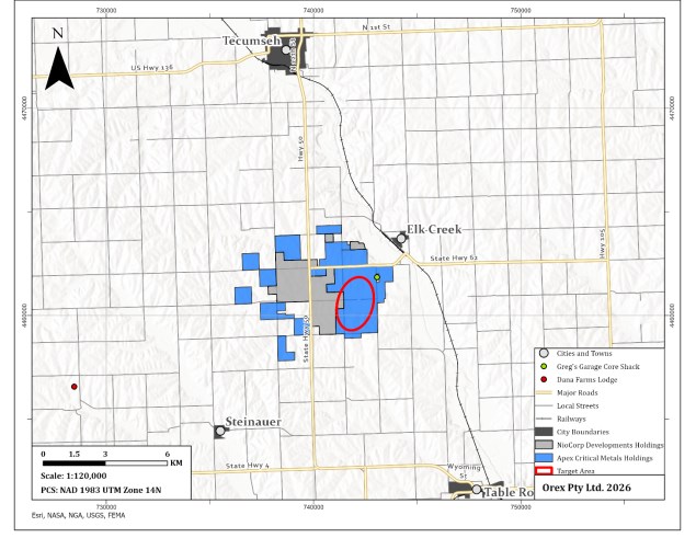
Figure 5-1 Rift Rare Earth Project Access Map
| Rift Project - Nebraska, USA |
6 History
6.1 Previous Exploration & Development
Earliest documented exploration in the area of the Property began with the execution of a regional airborne magnetic survey carried out by the U.S. Geological Survey ("USGS") in 1963 in southeastern Nebraska. The surveys were flown in an east-west direction with a line spacing of 3.2 km and altitude of 305 m, totalling 6,590 line-km (U.S. Geological Survey, 1973). The wide line spacing only provided regional features and did not identify any anomalies.
In 1970, the Conservation and Survey Division ("CDS") of the University of Nebraska-Lincoln ("UNL"), conducted a reconnaissance gravity survey in southeastern Nebraska and the UNL geology department (operating independently), was mapping the magnetic expression of the Nemaha Arch and Humbolt Fault. A comparison of the two survey results indicated a positive magnetic anomaly coincident with a positive gravity anomaly over what is now referred to as the Elk Creek gravity anomaly (Anzman, 1976). The geophysical gravity survey outlined a near-circular anomaly, along with a concurrent magnetic anomaly, approximately 7 km in diameter (Figure 6-1). Analysis of the geophysical data provided a model of a cylindrical mass of indefinite length with a radius of 1,676 m (5,500 ft) (Carlson & Treves, 2005).
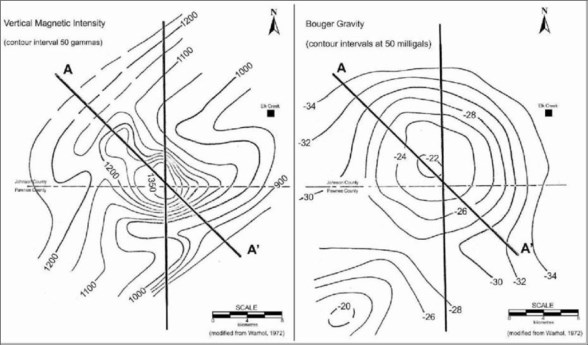
Figure 6-1 Comparison of the 1970 Magnetic and Gravity Geophysical Surveys (Tetra Tech, 2012)
In 1971, the Nebraska Geological Survey ("NGS") commissioned test drill hole 2-B-71 (later named NN-1 by Molycorp.), with the support of the United States Bureau of Mines ("USBM"), to determine the source of the near circular gravity anomaly. The drill hole encountered 191 m (628 ft) of marine sediments, followed by a carbonatite to the end of the hole at 290 m (952 ft), which is now referred to as the Elk Creek Carbonatite Complex (Brookins, Treves, & Bolivar, 1975).
| NI 43-101 Technical Report | |
Between 1973 and 1974, Cominco completed at least four drillholes within the Elk Creek anomaly, totalling 1,237 m, with one hole, CA-005 on the Property. All drillholes intersected Pennsylvanian sediments and carbonatite. Details of the historical drilling by Cominco is largely unavailable and only summarized in Molycorp documentation.
Between 1973 and 1986, Molycorp conducted multiple phases of drilling as well as more detailed geophysical surveys. The focus was on understanding the economic potential for rare earth elements on the Property. In 1973, Molycorp contracted Olympus Aerial Surveys Inc. ("Olympus Aerial") of Salt Lake City, Utah, USA, to complete a detailed aeromagnetic survey to aid in generating drillhole targets. Flight lines within the Elk Creek anomaly were spaced at 200 m and flight-lines outside the Elk Creek anomaly were spaced at 400 m, for a total of 2,090 line-km (Anzman, 1976). The altitude for the survey was not stated in Anzman (1976). In 1980, an extensive regional geophysical program was carried out in southeastern Nebraska including the Elk Creek anomaly. The program consisted of 6,437 line-km of aeromagnetics completed by Olympus Aerial and approximately 4,000 gravity station readings completed by the CDS-UNL and Molycorp's in-house Geophysical Services Group.
Table 6-1 Historical Drillhole Campaign Summary
| Year | Operator | Total Holes in Elk Creek Anomaly |
Total Holes on Property |
Total Meterage on Property |
| 1971 | Nebraska Geological Survey | 1 | 0 | 0 |
| 1973-1974 | Cominco | 4 | 1 | 317.6 |
| 1973-1986 | Molycorp | 106 | 29 | 10425.68 |
| 2011 | NioCorp | 5 | 1 | 465.73 |
Between 1973 and 1986, Molycorp drilled 106 holes totaling 46,076 m (Figure 6-2), within the Elk Creek anomaly. Most of the holes drilled prior to 1984 primarily targeted a central zone of high-grade niobium mineralization located outside the current Property boundary, as well as additional regional targets within the broader geophysical anomaly. The drilling campaigns after 1984 concentrated on systematic grid drilling of the Elk Creek carbonatite complex (Figure 6-2).
Of the 110 drillholes drilled by Molycorp and Cominco, thirty (30), totalling 10,425.7 m, were within the Property. Significant REE and Nb mineralization was intersected in several of these drillholes. The most significant intercepts are shown in the table below (Table 6-2).
Between 2010 and 2011, NioCorp conducted a two-phase exploration program at the Elk Creek Carbonatite targeting rare earth elements, that included resampling of historical sample material and a drill program. In 2010, NioCorp executed the resampling program of existing sample pulps and drill core rejects from nine historical Molycorp drillholes selected on the basis of known REE mineralization. The primary objective of the program was to reanalyze historical material using modern analytical techniques capable of quantifying the full suite of rare earth elements. Molycorp's original analyses had only included three rare earths - La, Ce and Nd. Samples were analyzed at ALS Minerals by lithium borate fusion ICP-MS, with REO values reported as the sum of all rare earth elements.
| Rift Project - Nebraska, USA |
The nine drillholes selected for reanalysis were distributed across three rare earth anomaly areas within the Elk Creek Carbonatite complex. Three of the nine re-analyzed drillholes fall within the current Property boundary: drillhole EC-004 in the western anomaly returned 15.2 m at 1.14% REO; EC-093 in the eastern anomaly returned 155.5 m at 2.70% REO including 54.9m at 3.30% REO; and EC-43, collared approximately 800 m to the southeast of EC-093 returned 134.1 m at 1.22% REO. The remaining six (6) drillholes that were re-analyzed in 2010 are located outside of the current Property.
In 2011, NioCorp completed a follow-up diamond drilling program consisting of five drillholes (NEC11-001 to NEC11-005) across their property; however, only one of those drill holes (NEC11-004) is located within the current Property boundary (Figure 6-2). The drill program comprised 3,420 m of NQ diamond core, with drill hole NEC11-004 drilled to a depth of 465.73 m. The drillhole intersected significant mineralization and returned 236.2 m at 2.10% REO, including 68.18 m at 3.32% REO (Table 6-2).
Table 6-2 Summary of Significant REO and Nb2O5 intercepts in Historical Drill Holes located within Rift Rare Earth Project
| Drillhole ID | From (m) |
To (m) | Interval (m) |
REO (%) |
Nb2O5 (%) |
LnO (%) | Reassay (2010 / 2025) |
| EC-003 | 240.79 | 241.4 | 0.6 | - | 0.70 | 0.20 | No |
| EC-004 | 217.93 | 233.17 | 15.2 | 1.83 | 0.08 | - | Yes |
| 259.08 | 269.75 | 10.7 | 2.77 | 0.08 | - | ||
| 286.51 | 332.23 | 45.0 | 1.94 | 0.17 | - | ||
| 344.42 | 356.25 | 11.8 | 1.56 | 0.14 | - | ||
| 371.86 | 396.24 | 24.4 | 1.53 | 0.15 | - | ||
| EC-004 | 504.44 | 512.06 | 7.6 | 0.45 | 0.80 | - | |
| incl. | 504.44 | 505.97 | 1.5 | 0.40 | 1.06 | - | |
| EC-004 | 522.73 | 525.78 | 3.1 | 1.85 | 0.16 | - | |
| 525.78 | 528.83 | 3.1 | 0.44 | 0.78 | - | ||
| 588.26 | 589.79 | 1.5 | 1.94 | 0.16 | - | ||
| 634.90 | 645.26 | 10.4 | 2.09 | 0.09 | - | ||
| 778.76 | 780.29 | 1.5 | 1.58 | 0.04 | - | ||
| EC-007 | 252.98 | 254.51 | 1.5 | - | 0.84 | 0.20 | No |
| EC-043 | 188.98 | 323.09 | 134.1 | 1.22 | 0.06 | - | Yes |
| 243.84 | 256.03 | 12.2 | 3.18 | 0.02 | - | ||
| 295.66 | 323.09 | 27.4 | 1.83 | 0.10 | - | ||
| 323.09 | 329.18 | 6.1 | 0.34 | 0.84 | - | ||
| EC-053 | 213.36 | 222.5 | 9.1 | 2.38 | 0.05 | - | Yes |
| 213.36 | 219.46 | 6.1 | 2.80 | 0.03 | - |
| NI 43-101 Technical Report | |
| EC-058 | 198.12 | 201.17 | 3.1 | 2.23 | 0.12 | - | Yes |
| 222.5 | 228.6 | 6.1 | 0.63 | 0.64 | - | ||
| 231.65 | 234.7 | 3.1 | 1.90 | 0.37 | - | ||
| EC-059 | 271.27 | 274.32 | 3.1 | 1.94 | 0.02 | - | Yes |
| EC-061 | 256.03 | 265.18 | 9.2 | - | 0.22 | 1.44 | No |
| EC-069 | 252.98 | 256.03 | 3.1 | - | 0.07 | 1.28 | No |
| EC-071 | 283.46 | 286.51 | 3.1 | 1.50 | 0.17 | - | Yes |
| EC-076 | 201.17 | 225.55 | 24.4 | 0.60 | 0.89 | - | Yes |
| incl. | 207.26 | 225.55 | 18.3 | 0.54 | 0.98 | - | |
| or | 207.26 | 213.36 | 6.1 | 0.50 | 1.26 | - | |
| EC-084 | 231.65 | 237.74 | 6.1 | 0.70 | 1.36 | - | Yes |
| incl. | 231.65 | 234.7 | 3.1 | 0.76 | 1.10 | - | |
| or | 234.7 | 237.74 | 3.0 | 0.64 | 1.62 | - | |
| EC-086 | 200.56 | 204.22 | 3.7 | 2.18 | 0.15 | - | Yes |
| 219.46 | 222.5 | 3.0 | 1.80 | 0.14 | - | ||
| EC-093 | 149.35 | 304.8 | 155.5 | 2.70 | 0.10 | - | Yes |
| 179.83 | 234.7 | 54.9 | 3.32 | 0.09 | - | ||
| EC-094 | 188.98 | 192.02 | 3.0 | 1.84 | 0.47 | - | Yes |
| EC-094 | 286.51 | 301.75 | 15.2 | 0.37 | 0.74 | - | |
| incl. | 286.51 | 289.56 | 3.1 | 0.32 | 1.04 | - | |
| EC-100 | 240.79 | 246.89 | 6.1 | 1.89 | 0.11 | - | Yes |
| EC-103 | 188.98 | 198.12 | 9.1 | 0.75 | 0.58 | - | Yes |
| 274.32 | 277.37 | 3.1 | 0.33 | 0.78 | - | ||
| EC-104 | 286.51 | 289.56 | 3.1 | 2.40 | 0.10 | - | Yes |
| EC-105 | 195.07 | 198.12 | 3.1 | 0.69 | 1.51 | - | Yes |
| 262.13 | 268.22 | 6.1 | 0.17 | 0.68 | - | ||
| NEC11-004 | 188.37 | 424.56 | 236.2 | 2.10 | 0.07 | - | No |
| 247 | 315.18 | 68.2 | 3.32 | 0.08 | - | ||
| 444.97 | 446.46 | 1.5 | 0.30 | 0.72 | - | ||
| 458.29 | 459.64 | 1.4 | 0.27 | 1.36 | - |
| Rift Project - Nebraska, USA |
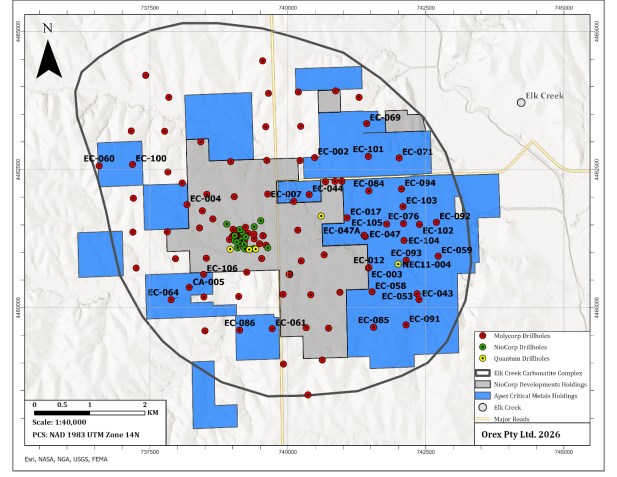
Figure 6-2 Historical Exploration Map
6.2 Prior Ownership
Historical ownership of mineral rights within the Rift Project area is not fully documented. Available records indicate that between 1971 and 1973, both Cominco and Molycorp held mineral rights over portions of the area historically referred to as the Elk Creek gravity anomaly (Daigle, Wardrop, 2011). The exact dates of initial acquisition by either company are unclear. Molycorp's earliest documented involvement in the area dates to 1973, and no further exploration activity by Molycorp in the Property area has been identified after 1986 (Daigle, 2011).
In 2010, NioCorp, through its subsidiary Elk Creek Resources Corp., acquired the Elk Creek Property through sixty-four (64) agreements with individual landowners. These agreements consisted of five-year prepaid Exploration Lease Agreements ("ELAs") that included OTPs the associated mineral rights at the conclusion of the lease term. The original Elk Creek Property encompassed portions of what is now referred to as the Rift Project.
6.3 Historical Mineral and Resource Estimates
There are no significant historical Mineral Resource or Reserves estimates on the Property.
| NI 43-101 Technical Report | |
6.4 Historical Production
There is no historical production reported on the Property.
| Rift Project - Nebraska, USA |
7 Geological Setting & Mineralization
7.1 Regional Geology
The Precambrian basement of southeastern Nebraska consists predominantly of granitic and mafic intrusive rocks, metamorphic gneiss and schist, anorthosite, basalt, and locally preserved clastic sedimentary rocks (Carlson & Treves, 2005). The regional basement architecture reflects Proterozoic accretionary tectonism involving the suturing of island arc terranes onto the southern margin of the Archean craton. Carlson and Treves (2005) described a north-trending intervening boundary zone ancestral to the Nemaha tectonic zone that later provided a structural framework controlling development of the Midcontinent Rift System.
The Midcontinent Rift System, also referred to as the Keweenawan Rift, is a Mesoproterozoic intracontinental rift system extending from the Lake Superior region southwestward through the central United States into Kansas (Ojakangas, Morey, & Green, 2001). The rift is characterized by extensive mafic volcanic and intrusive rocks together with associated clastic sedimentary sequences. Precambrian basaltic rocks and associated red clastic sedimentary rocks encountered within the subsurface of southeastern Nebraska have been correlated with Keweenawan-aged rocks recognized in the Lake Superior region (Figure 7-1) (Carlson & Treves, 2005).
The Nemaha Uplift is a major north-trending structural feature extending from southeastern Nebraska into Kansas. The uplift experienced significant Pennsylvanian to Early Permian reactivation during the Ancestral Rocky Mountain orogeny and is characterized by complex fault zones and steeply dipping strata along its margins (Burberry, Joeckel, & Korus, 2016). The Elk Creek carbonatite intrusion is located near the axis of the Nemaha Uplift and near the interpreted boundary between the Penokean orogen, formed at approximately 1.84 Ga, and the Dawes terrane of the Central Plains orogen, formed at approximately 1.78 Ga (Carlson & Treves, 2005). Xu (1996) interpreted emplacement of the Elk Creek carbonatite to have occurred at approximately 500 Ma in association with tectonic activity along the Nemaha structural zone. Three additional geophysical anomalies located along the Nemaha trend were subsequently drilled and interpreted to represent gabbroic intrusive rocks rather than additional carbonatite intrusions (Carlson & Treves, 2005).
| NI 43-101 Technical Report | |
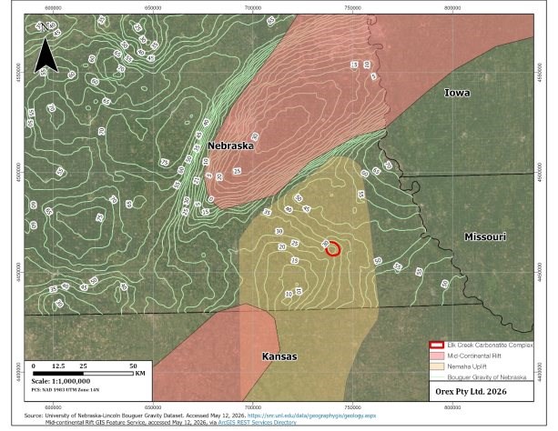
Figure 7-1 Regional Geology
7.2 Property Geology
The Property includes the carbonatite and mafic units that have intruded older Precambrian basement rocks consisting primarily of granite and biotite+/-amphibole gneisses, which are, unconformably overlain by approximately 200 m of flat-lying Pennsylvanian marine sediments. The marine sediments consist of limestone, sandstone, and shale. Surficial cover in the region consists primarily of unconsolidated Quaternary deposits.
The Elk Creek carbonatite complex is an elliptical magmatic body with a northwest-trending long axis perpendicular to the strike of the 1.1 Ga Midcontinent Rift System, near the northern part of the Nemaha uplift ( (Burchett, 1982); (Carlson M. P., 1992). Limited age dating of the Elk Creek complex has been carried out. Two potassium-argon determinations for biotite in an altered basalt yielded dates of 464 ± 5 and 484 ± 5 Ma (personal communications M. Ghazi, Georgia State University, reported by Carlson and Treves, 2005). A potassium-argon determination of another biotite from a silicate rock yielded an age of 544 ± 7 Ma. (personal communications Z.E. Paterman, United States Geological Survey, 1985, reported by Carlson and Treves, 2005). More recently U-Pb zircon dates from the carbonatite ranged from 540 ±14 to 480 ±20 Ma (Farmer, Chamberlain, & Babcock, 2013). All of these dates are younger than the Midcontinent Rift and they provide a generalized timeline for the carbonatite intrusion; however, additional geochronological dating is needed to establish a more precise age. Observations from the drillcore show that the contact between the carbonatite and Pennsylvanian sediments is strongly oxidized and sheared.
| Rift Project - Nebraska, USA |
The Elk Creek carbonatite consists predominantly of dolomite, calcite and ankerite, with lesser chlorite, barite, apatite, phlogopite, pyrochlore, serpentine, fluorite, sulphides and quartz (Xu, 1996). Molycorp defined lithological units within the carbonatite complex based on drilling and petrographic studies which included multiple beforsite, syenite, breccia, and mafic intrusive phases. Xu (1996) grouped the intrusive rocks of the Elk Creek complex into two principal phases: a carbonate phase and a silicate phase. The carbonate phase consists primarily of massive dolomite carbonatite and carbonatite breccia with subordinate apatite-, magnetite-, and hematite-bearing varieties. The silicate phase includes altered basaltic, lamprophyric, and syenitic intrusive rocks spatially associated with the carbonatite complex (Xu, 1996). Dahrouge Geological Consulting Ltd. (contracted by Apex for the 2026 drilling program) has simplified the units based on recent exploration and drilling; a summary of current lithologies is summarized in Table 7-1.
Table 7-1 Historical Molycorp Lithologic Nomenclature and Corresponding Current Lithologic Units
| Overlying Lithologies | Molycorp Unit Name | Code | Dahrouge Unit Name | Code |
| Quaternary Sediments | Qt | Overburden | Ovb | |
| Pennsylvanian Sediments | Pu | Pennsylvanian Sediments | Sed | |
| Elk Creek Complex | Younger Mafic | ym | maf | |
| - | - | Fenite | Fen | |
| Barite beforsite III | bb III | Dolomite carbonatite | dolCarb | |
| Barite beforsite II | bb II | |||
| Barite beforsite I | bb I | |||
| Beforsite breccia | bbx | Dolomite carbonatite breccia | dolCarbBc | |
| Apatite beforsite II | ab II | Dolomite carbonatite | dolCarb | |
| Apatite beforsite I | ab I | |||
| Magnetite beforsite | mb | Magnetite dolomite carbonatite | mdolCarb | |
| Older mafic rocks | om | Lamprophyre | lamp | |
| Lamprophyre breccia | lampbc | |||
| Gabbro | gab | |||
| Syenite II | sy II | Syenite | sy | |
| Syenite I | sy I | |||
| Host rocks | Granite/gneiss | pCgg | Granite | gr |
| Amphibole-biotite gneiss | pCbg | Gneiss | gn |
| NI 43-101 Technical Report | |
7.3 Mineralization
The Property hosts REE and niobium mineralization within the Elk Creek carbonatite complex. According to Molycorp, REE mineralization is strongly associated with the barite-bearing beforsite and related carbonatite units while the niobium mineralization is commonly associated with pyrochlore-bearing and magnetite-bearing beforsite. Apatite-bearing beforsite is associated with elevated phosphate concentrations (Shearer, 1985). Rare earth mineralization is primarily hosted in bastnäsite, parisite, synchysite, and monazite, while niobium mineralization is primarily associated with pyrochlore (Xu, 1996; Verplanck, et al., 2022).
REE mineralization occurs as fine-grained disseminations, aggregates, radial patches, and vein-like concentrations of lanthanide minerals within the carbonatite. Petrographic descriptions from Molycorp drill hole EC-93 describe REE-bearing mineral aggregates occurring within hematite-altered beforsite, with monazite and bastnäsite identified within the aggregates. Larger intervals of lanthanide mineralization were reported in barite beforsite units and undivided beforsite, although REE minerals were also observed in older mafic rocks, apatite beforsite, beforsite breccia, and younger mafic rocks.
Recent drilling by Apex has expanded the footprint of high-grade REE mineralization within the Property area, including the Trinity Zone and the NdPr-enriched Neo Zone (for more information please see Section 10.1: Drill Results). Publicly disclosed drill results indicate broad intervals of REE mineralization associated with carbonatite and hematite-altered dolomite carbonatite lithologies consistent with historical Molycorp observations. Host mineralogy for the 2026 Apex drillholes has not yet been formally characterized; however, analytical results, drill core visual characteristics, and REE ratios are consistent with the mineralogy documented by Molycorp. The Company has planned to perform both TIMA and XRD analyses on representative samples to confirm REE host mineralogy of both the Trinity and Neo zones.
| Rift Project - Nebraska, USA |
8 Deposit Type
Carbonatite-associated deposits are important global sources of rare earth elements, niobium, phosphate, fluorite, barite, vermiculite, and related critical mineral commodities (Richardson & Birkett, 1996; Verplanck, Van Gosen, Seal, & McCafferty, 2014). A carbonatite is defined as an igneous rock body with greater than 50% modal carbonate minerals, mainly in the form of calcite-, dolomite-, ankerite-, or sodium- and potassium-bearing carbonates. Many carbonatites are associated with alkaline silicate rocks including syenite, nepheline syenite, ijolite, urtite, and pyroxenite and are commonly surrounded by an aureole of metasomatically altered rocks referred to as fenites (Richardson & Birkett, 1996).
Carbonatites are commonly classified into four principal compositional groups based on dominant carbonate mineralogy and geochemistry (Woolley & Kempe, 1989); (Woolley & Kjarsgaard, 2008): calcio-carbonatite (calcite-rich), magnesio-carbonatite (dolomite-rich), ferrocarbonatite (iron-rich carbonates), and natrocarbonatite (sodium-potassium-calcium carbonates). These groups may be further subdivided according to mineralogical composition and texture, including coarse-grained sövite and finer-grained alvikite varieties within calcio-carbonatites, and beforsite and rauhaugite varieties within magnesio-carbonatites. The use of a chemical classification of carbonatites should be used with caution when replacement, or metasomatic, processes have altered the primary composition of the carbonatite rock (Mitchell, 2005).
Carbonatites are generally related to large-scale, intra-plate fractures, grabens, or rifts that correlate with periods of extension, and range from Precambrian to recent in age. It is also important to note that carbonatites tend to occur in clusters, and many regions, have experienced repeated intrusive activity over time. Carbonatites are most commonly emplaced as intrusive bodies, including plugs, dykes, sills, and breccia complexes, and only rarely occur as extrusive rocks.
Carbonatite-associated mineral deposits may be classified as either magmatic, or metasomatic in origin (Richardson & Birkett, 1996). Magmatic mineralization forms during crystallization and differentiation of carbonatite magma, whereas metasomatic mineralization develops through interaction between late-stage fluids and surrounding country rocks or earlier intrusive phases.
Pipe-like carbonatites commonly occur as sub-circular to elliptical intrusive bodies that may reach up to 3-4 km in diameter. Magmatic mineralization within these systems is often concentrated in crescent-shaped, steeply dipping zones. Carbonatite magmas are typically volatile-rich and characterized by relatively low viscosity, allowing rapid ascent through the crust. Rapid emplacement can result in fracturing of the surrounding country rock and the development of characteristic ring or crescent-shaped intrusive patterns consisting of alternating carbonatite and wall-rock units.
Metasomatic and hydrothermal mineralization associated with carbonatites commonly occurs as irregular bodies, breccias, stockworks, or vein systems. Carbonatite complexes generally comprise multiple intrusive phases exhibiting distinct mineralogical, geochemical, and textural characteristics. Early intrusive phases are typically dominated by calcite-rich calcio-carbonatite, whereas later phases commonly become progressively enriched in dolomite, ankerite, or siderite, corresponding to magnesio-carbonatite and ferro-carbonatite compositions.
| NI 43-101 Technical Report | |
Late-stage intrusive and hydrothermal phases are commonly enriched in incompatible elements, including niobium, tantalum, and REE. In general, geochemical zonation within carbonatite complexes progresses from early calcio-carbonatite intrusions to magnesio-carbonatite and ultimately ferro-carbonatite phases, with REE enrichment frequently associated with the latest stages of magmatic and hydrothermal evolution.
Fenitization, an alkali metasomatic alteration process affecting surrounding country rocks, is a characteristic feature adjacent to many carbonatite intrusions and may serve as an important exploration vector toward mineralized zones.
| Rift Project - Nebraska, USA |
9 Exploration
In November 2025, Apex completed a re-logging and re-sampling program on historical drill core from the Property. The program was designed to improve the understanding of REE mineralization and establish a modern geochemical baseline for the Rift Project through the application of current geological and analytical methods to drill core originally drilled by Molycorp during the 1970s and 1980s. These drill holes were not included in the 2010 re-assay program completed by NioCorp. Molycorp's original analytical program reported only three REEs-lanthanum ("La"), cerium ("Ce"), and neodymium ("Nd")-which were typically combined and reported as LnO.
All historical Molycorp's drill core from the Elk Creek Carbonatite complex, as well as a significant inventory of sample material, including pulverized and coarse-reject sample material, is preserved through the Conservation and Survey Division, School of Natural Resources at the University of Nebraska-Lincoln.
The 2025 re-logging and re-sampling program consisted of:
Table 9-1 Summary 2025 Re-logged and Re-assayed Drillholes
| Drillhole ID | Re-assayed / Re-logged | Drillhole ID | Re-assayed / Re-logged | |
| CA-003 | Re-assayed | EC-059 | Re-assayed & Re-logged | |
| EC-043 | Re-assayed | EC-060 | Re-assayed & Re-logged | |
| EC-071 | Re-assayed | EC-076 | Re-assayed & Re-logged | |
| EC-084 | Re-assayed | EC-085 | Re-assayed & Re-logged | |
| EC-086 | Re-assayed | EC-091 | Re-assayed & Re-logged | |
| EC-094 | Re-assayed | EC-092 | Re-assayed & Re-logged | |
| EC-101 | Re-assayed | EC-100 | Re-assayed & Re-logged | |
| EC-004 | Re-assayed & Re-logged | EC-103 | Re-assayed & Re-logged | |
| EC-012 | Re-assayed & Re-logged | EC-104 | Re-assayed & Re-logged | |
| EC-053 | Re-assayed & Re-logged | EC-105 | Re-assayed & Re-logged | |
| EC-058 | Re-assayed & Re-logged |
Data from the program was uploaded into an MX Deposit database and used to refine drill targets in a Leapfrog geological model for the drill program initiated in January 2026.
| NI 43-101 Technical Report | |
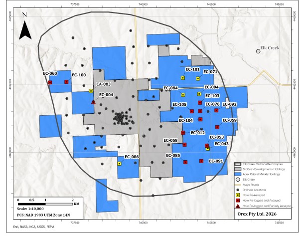
Figure 9-1 Exploration Map
9.1 Results
A total of 1,250 historical samples from 21 drill holes were selected and submitted for analysis. Comparison of the new analytical results with historical data demonstrated that total rare earth oxide (REO%) values were consistently higher than the historical LnO% values, with positive differences ranging from 4% to 16% (Figure 9-2). On average, REO% values exceeded historical LnO% values by approximately 8.8%.
Although the program did not identify previously unrecognized anomalous REE mineralization, it confirmed the presence of elevated REE concentrations within the Property and established modern baseline REE values for the principal lithological units. These results provide an improved geochemical framework for ongoing exploration and resource evaluation.
| Rift Project - Nebraska, USA |
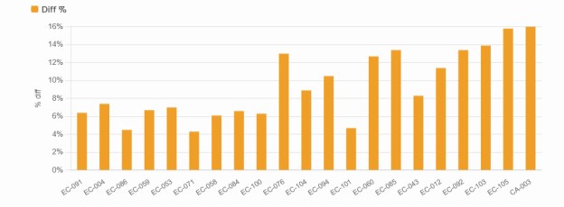
Figure 9-2 Mean difference % (REO- LnO) / REO - by hole
| NI 43-101 Technical Report | |
10 Drilling
As of the Effective Date of this Technical Report, Apex is currently conducting an initial diamond drill program at the Rift Project. The program is designed to confirm and expand upon historical drilling completed by Molycorp (e.g., EC-093, EC-104, EC-053, and EC-043) and NioCorp (NEC11-004), and to evaluate the continuity of mineralization along strike to the north and south. The program also aims to improve understanding of the geometry and structural controls on mineralization within the carbonatite body.
As of the Effective Date of this Technical Report, a total of fifteen (15) drillholes totalling, 11,088 m have been completed, with drilling ongoing. Assay results have been received for five (5) drillholes, RIFT26-001A through RIFT26-005A, with partial results received for RIFT26-006 and pending for the remaining nine (9) completed drillholes. This Technical Report presents drilling results for RIFT26-001A through RIFT26-006 only, with results for the remaining drillholes to be incorporated as assays are received and verified.
Two drillholes from the 2026 program required abandonment and redrilling prior to reaching target depth due to drilling-related issues. RIFT26-001 was abandoned and subsequently redrilled from the same collar location as RIFT26-001A; RIFT26-005 was similarly abandoned and redrilled as RIFT26-005A. Both redrilled holes successfully reached target depth and returned the assay results presented in this Technical Report. The abandoned holes were not assayed and are not described further in this Technical Report.
Drilling is being carried out by Boart Longyear using two surface core drilling rigs, consisting of one truck-mounted and one track-mounted rig operating concurrently. Drillholes are advanced using a tricone roller bit through overburden, followed by HQ-size diamond drilling to the end of hole.
All completed drill holes have been surveyed with a continuous Reflex Gyro survey tool with surveys (azimuth and inclination) recorded approximately every ~9 m downhole to the end of hole. Collar coordinates are set out in the field using a handheld GPS (with sub-metre accuracy) and confirmed once the drilling rig has been set up with a Differential GPS (Trimble DA2) which has centimetre accuracy.
Optical televiewer (OTV) and acoustic televiewer (ATV) borehole surveys were completed in drill holes RIFT26-001A, RIFT26-004, RIFT26-005A, and RIFT26-008. These surveys provide continuous digital imagery and acoustic reflectance data from the borehole wall, enabling structural orientation measurements on a per-feature basis and supplementing the geological core log. OTV and ATV data are being used to assist in the interpretation of structural controls on mineralization and to support geological modelling.
Access to drill sites is provided by local roads and agricultural access routes. Drill core is placed in labelled core boxes at the drill site and transported by truck to a secure logging and sampling facility. Core recovery has been generally good throughout the 2026 drilling program, and no significant issues have been identified that would be expected to materially affect the quality or reliability of the drilling results. Core sampling protocols followed industry standard practices. Upon receipt at the core shack, all drill core was pieced together, oriented to maximum foliation, metre-marked, geotechnically logged (including structures), alteration logged, geologically logged, and sample logged on an individual sample basis. A handheld XRF was present onsite to guide sampling as required. Geological data was recorded using MX Deposit software. Wet and dry core box photographs were taken of all drill cores received, regardless of perceived mineralization. Field specific gravity (SG) measurements of drill core are collected using a dry volumetric density method at systematic intervals of approximately one measurement per ~12 m. Detailed sampling, analytical procedures, specific gravity procedures, and quality assurance/quality control protocols are described in Section 11 (Sample Preparation, Analysis & Security).
| Rift Project - Nebraska, USA |
The 2026 drilling program is managed by Dahrouge Geological Consulting Ltd. on behalf of Apex. Drillhole collar locations, orientations, and lengths are summarized in Table 10-1. Significant results from RIFT26-001A through RIFT26-005A and partial results from RIFT26-006 are presented in Table 10-2.
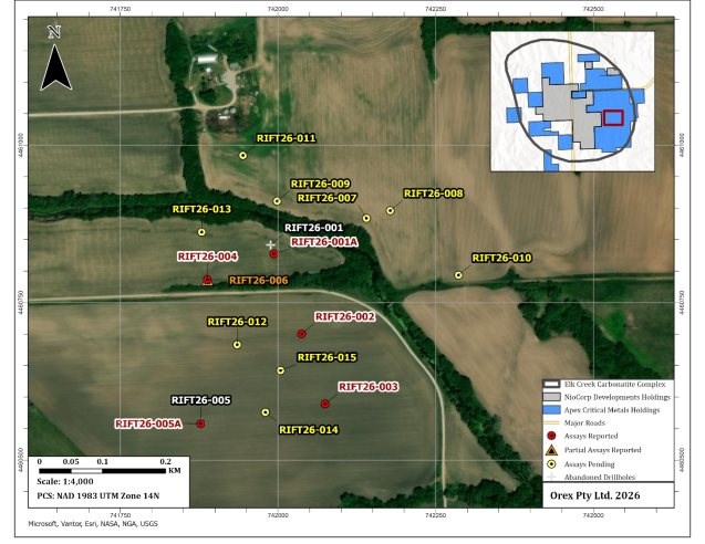
Figure 10-1 Drillhole Location Map
Table 10-1 2026 Drillhole Locations and Attributes
| Drillhole ID | Azimuth (°) |
Dip (°) |
Depth (m) |
Easting | Northing | Elevation (masl) |
ATV/OTV Survey |
Assays Received |
| RIFT26-001 | 80 | -60 | 52.6 | 741988.3 | 4460842 | 333.4 | No | No |
| NI 43-101 Technical Report | |
| Drillhole ID | Azimuth (°) |
Dip (°) |
Depth (m) |
Easting | Northing | Elevation (masl) |
ATV/OTV Survey |
Assays Received |
|
RIFT26-001A |
80 |
-60 |
822.66 |
741993.5 |
4460827 |
332.3 |
Yes |
Yes |
|
RIFT26-002 |
80 |
-60 |
600.46 |
742037.5 |
4460700 |
331.3 |
No |
Yes |
|
RIFT26-003 |
80 |
-60 |
871.83 |
742074.7 |
4460589 |
331.2 |
No |
Yes |
|
RIFT26-004 |
80 |
-60 |
710.16 |
741888.1 |
4460787 |
332.2 |
Yes |
Yes |
|
RIFT26-005 |
80 |
-60 |
51.82 |
741878 |
4460559 |
333.5 |
No |
No |
|
RIFT26-005A |
80 |
-60 |
806.23 |
741877.4 |
4460558 |
333.1 |
Yes |
Yes |
|
RIFT26-006 |
80 |
-70 |
862.85 |
741888.1 |
4460787 |
332.2 |
No |
Partial (0 to 500. 8 m) |
|
RIFT26-007 |
0 |
-90 |
600.79 |
742140.2 |
4460884 |
331.3 |
No |
No |
|
RIFT26-008 |
200 |
-65 |
894.78 |
742177.9 |
4460896 |
330.1 |
Yes |
No |
|
RIFT26-009 |
80 |
-60 |
576.07 |
741998.7 |
4460911 |
333.0 |
No |
No |
|
RIFT26-010 |
260 |
-60 |
603.4 |
742286.1 |
4460794 |
330.9 |
No |
No |
|
RIFT26-011 |
80 |
-60 |
560.41 |
741944.4 |
4460984 |
332.8 |
No |
No |
|
RIFT26-012 |
80 |
-65 |
685.93 |
741935.3 |
4460683 |
331.9 |
No |
No |
|
RIFT26-013 |
80 |
-60 |
618.93 |
741879.1 |
4460862 |
333.0 |
No |
No |
|
RIFT26-014 |
80 |
-60 |
829.32 |
741980 |
4460576 |
332.6 |
No |
No |
|
RIFT26-015 |
75 |
-65 |
774.73 |
742004.1 |
4460642 |
331.4 |
No |
No |
(1) Dip and Azimuth are planned and may vary downhole. (2) All coordinates presented in NAD83 Z14. All drill core is HQ in size
| Rift Project - Nebraska, USA |
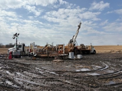
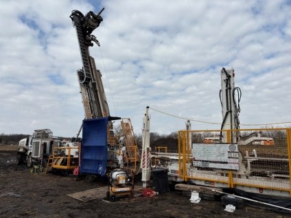
Figure 10-2 Drilling in progress at Rift Rare Earth Project - RIFT26-006 and RIFT26-005A
10.1 2026 Drill Results
All six (6) drillholes for which assay results have been received intersected continuous carbonatite over significant intervals, consistent with the historical drillholes within the Elk Creek Carbonatite Complex. Rare earth element mineralization exhibits a consistent spatial association with hematite alteration within the carbonatite, which has been used as a visual proxy for elevated REO values by site geologists throughout the program. The correlation has been confirmed by assay results across the reported drillholes.
The carbonatite body is unconformably overlain by Pennsylvanian sedimentary rocks. High-grade REO mineralization is observed predominantly within the uppermost carbonatite immediately below the unconformity. A secondary zone of elevated neodymium-praseodymium (NdPr) enrichment has been identified at depth in drillholes RIFT26-002 and RIFT26-003, beneath the upper high-grade horizon. These two zones together defined a two-horizon mineralized system that represents the primary targets for exploration at the Rift Project.
Apex has termed the upper-high grade REO horizon as the Trinity Zone, and the deeper NdPr enriched horizon as the Neo Zone.
10.1.1 RIFT26-001A
Drill hole RIFT26-001A was designed to test REE potential approximately 150 m west and 40 m north of historical drill holes EC-93 and NEC11-004, respectively. The drillhole was intended to expand the known Trinity Zone mineralization laterally and evaluate the northwestern extent of the carbonatite body. RIFT26-001A was drilled to a total depth of 822.66 m at an azimuth of 080 degrees and a dip of -60 degrees.
| NI 43-101 Technical Report | |
The drill hole intersected hematite-altered carbonatite with elevated REO grades, confirming the extension of Trinity Zone mineralization to the northwest of the historical reference holes. The most significant reported intercept is 45.0 m at 2.07% REO, including a higher-grade interval of 24.9 m at 2.40% REO, both of which occur within a broader mineralized envelope of 142.8 m at 1.48% REO (Figure 10-3, Table 10-2). These results extend both the lateral footprint and the interpreted depth extent of the Trinity Zone in the vicinity of historical holes EC-93 and NEC11-004.
10.1.2 RIFT26-002
Drill hole RIFT26-002 was designed as a southern step-out from historical drill hole NEC11-004, positioned approximately 100 m to the south. The objective was to test the southward continuity of REO mineralization beyond the historical drill coverage and to evaluate the strike extent of the mineralized carbonatite corridor. The drillhole was drilled to a total depth of 600.5 m at an azimuth of 080 degrees and a dip of -60 degrees.
Assay results confirmed strong Trinity Zone REO mineralization in the upper carbonatite, with 81.6 m at 2.02% REO, including a higher-grade interval of 50.9 m at 2.40% REO (Figure 10-3, Table 10-2). Seventeen (17) individual samples exceeded 3.00% REO.
In addition to the Trinity Zone, RIFT26-002 intersected the first occurrence of the Neo Zone at depth, returning 10.0 m at 0.75% REO with an average NdPr distribution of 49.0% (Table 10-3). NdPr distributions in carbonatite-hosted rare earth deposits globally typically range from 14 to 20%. This intersection was the first documented occurrence of the Neo Zone at the Rift Project.
10.1.3 RIFT26-003
Drill hole RIFT26-003 was designed as a further southern step-out from RIFT26-002, positioned approximately 120 m to the south, to test along-strike continuity of both the Trinity Zone and the Neo Zone. The drillhole was advanced to a total depth of 871.8 m at an azimuth of 080 degrees and a dip of -60 degrees. Assay results from RIFT26-003 are discussed separately for the upper portion (surface to 389.3 m depth), evaluated with respect to the Trinity Zone, and the lower portion (390.0 m to 871.8 m), evaluated with respect to the Neo Zone.
Trinity Zone
Assay results from the upper portion of RIFT26-003 confirm the southward extension of Trinity Zone mineralization. The high-grade interval was intersected immediately below the unconformity, consistent with observations from all previously reported drill holes. The drillhole returned 80.0 m at 2.29% REO, including 23.7 m at 4.02% REO, within a broader mineralized envelope of 124.0 m at 1.94% REO (Figure 10-3, Table 10-2). Twenty-two (22) individual samples exceeded 3.00% REO, and ten (10) samples exceeded 4.00% REO, to a maximum of 6.54% REO. These results extend the high-grade Trinity Zone trend approximately 275 m south of historical drill hole EC-93.
Neo Zone
Assay results from the lower portion of RIFT26-003 (390.0 m to 871.8 m) confirmed and materially expanded the Neo Zone first identified in RIFT26-002. Multiple discrete intervals of elevated NdPr distribution were returned across the lower approximately 480 m of the drill hole, demonstrating the significant vertical extent of the zone (Table 10-3).
| Rift Project - Nebraska, USA |
All reported NdPr distributions from the Neo Zone in RIFT26-003 significantly exceed the 14-20% range typical of carbonatite-hosted deposits globally. The confirmation of the Neo Zone at depth in both RIFT26-002 and RIFT26-003, two holes drilled 120 m apart supports lateral continuity of the zone between the two drillholes. The apparent width of the Neo Zone expands materially from RIFT26-002 (10 m) to RIFT26-003 (multiple intervals distributed over approximately 480 m of drill hole), consistent with either a southward thickening of the enriched horizon or RIFT26-002 intersecting only the northern margin of the feature.
10.1.4 RIFT26-004
Drill hole RIFT26-004 was drilled from a common surface pad with RIFT26-006, at an azimuth of 080 degrees and a dip of -60 degrees, to a total depth of 710.2 m. The drillhole was designed to test the down-dip western extension of Trinity Zone mineralization previously intersected in historical drill hole NEC11-004 and in RIFT26-001A.
RIFT26-004 intersected the Trinity Zone as two discrete intervals. The shallower interval returned 39.5 m at 1.38% REO from 192.6 m depth, including a higher-grade interval of 15.6 m at 2.10% REO from 216.5 m to 232.1 m. A second, deeper interval of 18.8 m at 2.01% REO was intersected from 320.6 m to 339.4 m depth (Figure 10-3, Table 10-2). The two intervals are separated by a lower-grade zone and may reflect either distinct stacked mineralized horizons or a single zone interrupted by fenite or lower-grade carbonatite. The down-dip positions of these intercepts are consistent with the interpreted shallow westward dip of the Trinity Zone.
10.1.5 RIFT26-005A
Drill hole RIFT26-005A was designed as an approximately 180 m western step-out from RIFT26-003, targeting the down-dip extension of the Trinity Zone at depth. The hole was drilled at an azimuth of 080 degrees and a dip of -60 degrees to a total depth of 806.2 m.
RIFT26-005A returned the widest high-grade Trinity Zone intercept of the 2026 program to date, with 137.2 m at 2.01% REO from 252.6 m to 389.8 m depth. This result confirms the Trinity Zone footprint extends in the down-dip direction relative to RIFT26-003. Nineteen (19) individual samples within the 137.2 m interval graded above 4.00% REO, to a maximum of 6.59% REO. The 137.2 m interval contains a high-grade interval of 23.1 m at 3.47% REO from 290.5 m to 313.5 m, including 11.0 m at 4.39% REO from 302.5 m to 313.5 m. Full interval details are presented in Table 10-2 and Figure 10-3.
10.1.6 RIFT26-006
Drill hole RIFT26-006 was drilled from the same surface pad as RIFT26-004, at an azimuth of 080 degrees and a steeper dip of -70 degrees, targeting deeper down-dip extensions of the Trinity Zone. The total depth of the hole is 862.85 m. Partial assay results have been received for the interval from 162.2 m to 500.8 m depth, with assays for the remaining downhole length pending.
| NI 43-101 Technical Report | |
The partial results from RIFT26-006 returned a broad, continuous mineralized interval of 210.0 m at 1.33% REO from 191.8 m depth, encompassing two distinct higher-grade intervals: 43.2 m at 1.61% REO from 200.2 m depth; and 43.8 m at 2.75% REO from approximately 358.0 m depth, including 34.1 m at 3.05% REO from 364.0 m depth (Figure 10-3 and Table 10-2). Assay results for the deeper portion of RIFT26-006 remain pending and will be reported upon receipt and verification.
Table 10-2 Summary of Significant Results from Trinity Zone - 2026 Drill Program
|
Hole ID |
Zone |
From (m) |
To (m) |
Interval |
REO (%) |
|
RIFT26-001A |
Trinity |
177.0 |
319.8 |
142.8 |
1.48 |
|
including |
Trinity |
248.4 |
293.4 |
45.0 |
2.07 |
|
including |
Trinity |
248.4 |
273.3 |
24.9 |
2.40 |
|
RIFT26-002 |
Trinity |
213.8 |
295.4 |
81.6 |
2.02 |
|
including |
Trinity |
244.5 |
295.4 |
50.9 |
2.40 |
|
including |
Trinity |
279.3 |
291.2 |
11.9 |
3.04 |
|
RIFT26-003 |
Trinity |
177.0 |
301.0 |
124.0 |
1.94 |
|
including |
Trinity |
177.0 |
257.0 |
80.0 |
2.29 |
|
including |
Trinity |
177.0 |
200.7 |
23.7 |
4.02 |
|
RIFT26-004 |
Trinity |
192.6 |
232.1 |
39.5 |
1.38 |
|
including |
Trinity |
216.5 |
232.1 |
15.6 |
2.10 |
|
RIFT26-004 |
Trinity |
320.6 |
339.4 |
18.8 |
2.01 |
|
RIFT26-005A |
Trinity |
252.6 |
389.8 |
137.2 |
2.01 |
|
RIFT26-005A |
Trinity |
290.5 |
370.4 |
80.0 |
2.51 |
|
including |
Trinity |
290.5 |
313.5 |
23.1 |
3.47 |
|
including |
Trinity |
302.5 |
313.5 |
11.0 |
4.39 |
|
RIFT26-005A |
Trinity |
418.5 |
426.0 |
7.5 |
1.80 |
|
RIFT26-006 |
Trinity |
191.8 |
401.8 |
210.0 |
1.33 |
|
including |
Trinity |
200.2 |
243.3 |
43.2 |
1.61 |
|
RIFT26-006 |
Trinity |
358.0 |
401.8 |
43.8 |
2.75 |
|
including |
Trinity |
364.0 |
398.0 |
34.1 |
3.05 |
(1) All presented intervals are core length and do not represent true width
Table 10-3 Summary of Significant Results from Neo Zone - 2026 Drill Program
| Hole ID | Zone | From (m) |
To (m) | Interval (m) (1) |
REO (%) | NdPr Dist. (%) |
| RIFT26-002 | Neo Zone | 484.9 | 494.9 | 10 | 0.75 | 49 |
| RIFT26-003 | Neo Zone | 514.7 | 528.1 | 13.5 | 1.08 | 31.7 |
| RIFT26-003 | Neo Zone | 557.5 | 574.7 | 17.2 | 0.89 | 39.4 |
| RIFT26-003 | Neo Zone | 687.0 | 709.7 | 22.7 | 0.79 | 32.8 |
| Rift Project - Nebraska, USA |
| Hole ID | Zone | From (m) |
To (m) | Interval (m) (1) |
REO (%) | NdPr Dist. (%) |
|
including |
Neo Zone |
687.0 |
697.9 |
10.9 |
0.99 |
30.1 |
|
RIFT26-003 |
Neo Zone |
751.4 |
762.0 |
10.5 |
0.91 |
35.2 |
|
RIFT26-003 |
Neo Zone |
783.0 |
788.5 |
5.5 |
0.87 |
34.3 |
(1) All presented intervals are core length and do not represent true width
All reported intervals represent downhole core lengths and do not represent true widths. The true thickness of mineralization has not been established at this stage of exploration. Preliminary geological interpretation suggests the Trinity Zone dips shallowly to the west, though this requires confirmation through additional drilling and geological modelling. The geometry of the Neo Zone is less constrained. Additional drilling at varied orientations and continued geological modelling, as recommended in Section 26, will address true thickness determination for both zones.
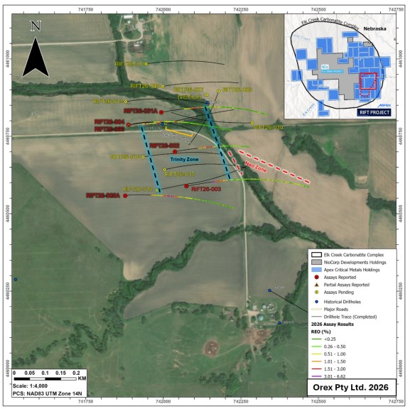
Figure 10-3 2026 Drilling - Assay Results (REO %)
| NI 43-101 Technical Report | |
11 Sample Preparation, Analysis & Security
The below summarizes sampling methodologies used by Molycorp (1973-1986), NioCorp (2010-2011) and Apex (2025-2026).
11.1 Pre-Analysis Sample Preparation and Quality Control
11.1.1 MolyCorp Drill Programs (1976-1986)
Detailed descriptions of Molycorp's sampling methodologies and quality control have not been documented nor has it been reviewed by the Author. No photographs of core were included with Molycorp's available records. Based on the available data, samples were usually collected from 1.52 m or 3.05 m core intervals, with local intervals as short as 0.06 m. According to a sampling technician, Ms. Beverly Beethe, the samples were hydraulically split and crushed onsite with the core crusher cleaned between samples using a limestone blank material (Daigle, 2011). No details on sample homogenization were available in the records. Samples were then sent to Molycorp's exploration laboratory in Louviers, Colorado for analysis. Some 3.05 m samples were split and combined into either approximately 15 m or 30 m composites and sent to commercial laboratories for independent assays; however, the procedures associated with generating these composites are unknown at this time.
11.1.2 NioCorp Resample Program (2010)
The 2010 resample program utilized pulverized and coarse-crush material from select intervals of Molycorp drillholes that were originally prepared by the analytical division of Molycorp. Samples were generally derived from 1.52 m or 3.05 m intervals of split NQ or BQ diameter size core, and stored at the Mead Core facility in labelled paper manila envelopes and plastic bags. Pulp or pulverized samples were targeted, however, if none were available then the coarse-reject material was riffle split. All samples were uniquely labelled and placed in 5-gallon pails for shipment to the designated lab. QA/QC samples including field duplicates, pulp duplicates and certified reference material were inserted into the sample sequence. The selected samples were shipped to ALS Minerals in Reno, Nevada, USA and subsequently analyzed at ALS Labs in Vancouver, BC ("ALS").
11.1.3 Apex Resample Program (2025):
The 2025 resample program utilized pulverized and coarse-crush material from select intervals of the Molycorp drillholes that were originally prepared by the analytical division of Molycorp. Samples were generally derived from 1.52 m or 3.05 m intervals of split NQ or BQ diameter size core. Sample material is stored at the Mead Core facility in labelled manila paper envelopes and plastic bags. The sample envelopes were placed in small plastic bags and uniquely labelled before being inventoried and sealed in 5-gallon pails. QA/QC samples including pulp duplicates, blanks and certified reference material were inserted into the sample sequence. All samples were stored in a secure location until being shipped via courier to Actlabs in Ancaster, ON. Actlabs is an independent, ISO/IEC 17025-accredited commercial laboratory with no affiliation to Apex.
11.1.4 Drill Programs (2011 & 2026)
In 2011 and 2026 drill core was boxed at the drill site and delivered to the core processing facility where it was logged, photographed and cut (Figure 11-1). Samples were marked with a solid red line drawn perpendicular to the core, and arrow(s) pointing in the direction of the sample(s). Within the carbonatite, samples were generally 1.0 m in length, while wall rock samples were generally 1.5 m in length. Sample lengths were adjusted based on alteration, mineralization, texture, rubble zones and any other distinctive geological feature, so that samples do not cross these geological boundaries. Sample numbers and depths were written on the top half of the core and corresponding numbered labelled sample tags are stapled to the edge of the box close to the start of each sample interval. QA/QC samples including 1/4 core duplicates, pulp duplicates, reject duplicates, quartz blanks and certified reference material were inserted into the sample streams at a rate of 1 per every 20 core samples. Core blocks written with sample numbers and QAQC sample type were inserted to mark the position of the QA/QC samples in the sample sequence. Core was then photographed and sawed along the red lines (using a rock saw) and returned to the core trays. Samples were then bagged, prepared for shipping and stored in a secure location prior to being shipped via a freight company to the laboratory. Additionally, 5% of the samples were selected for coarse-reject splits and pulp splits to be sent to a secondary (external) laboratory for check analysis.
| Rift Project - Nebraska, USA |
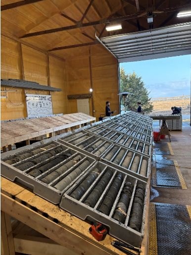
Figure 11-1 Core logging facility at Rift Rare Earth Project
| NI 43-101 Technical Report | |
11.2 Laboratory Sample Preparation & Analysis
The primary lab that Molycorp used for sample analysis was the Louviers facility in Colorado. No details on the sample preparation and analysis were documented. Additionally, Molycorp did send some samples to commercial laboratories including Skyline Labs Inc., in Wheat Ridge, Colorado for composite analysis and comparison of results between 1980 and 1986. In an internal memo by Sisneros and Yernberg (1983), it is noted that the routine XRF analysis performed at Louviers generated niobium values that were higher than other analytical techniques. It was concluded that the difference was the results of the standardization errors in the XRF analytical technique due to the high barium and iron content within the sample matrix. Following round-robin testing, the XRF instrument at Louviers was re-calibrated and many of the previously analyzed samples were re-tested with the new calibration. Samples from holes drilled prior to 1983 with the Ba+Fe correction are noted in the historical analytical logs and it is expected that the samples from the holes drilled after 1983 were analyzed with the new calibration.
Sample preparation at ALS laboratories and ActLabs included weighing received samples (RX10; WEI-21), crushing material to up to 80% passing 2 mm, riffle splitting 250g and then pulverizing (mild steel) to 95% passing <74µm (200 mesh). Samples were analyzed using the methods summarized in Table 11-1.
Table 11-1 Summary of Laboratory Methods
| Primary Lab | Year | Package | Elements | Description |
| Louviers (Molycorp) | 1973-1986 | Not Defined | Nb2O5 | Pressed powder pellet with XRF finish |
| 1973-1986 | Not Defined | LnO | Pressed powder pellet with XRF finish | |
| ALS | 2010 | ME-ICP06 | Major Oxides | Lithium borate fusion with an ICP-OES |
| 2010 | ME-MS81h | REEs | Lithium borate fusion with an ICP-MS finish | |
| 2010 | ME-XRF10 | Trace & REE | Lithium borate fusion with an XRF finish | |
| ActLabs | 2011 | 4F-F | F | Assay by lithium borate fusion and acid dissolution with analysis by Ion Selective Electrode (ISE) |
| 2011; 2025-2026 | 8-XRF | Nb2O5-Ta2O5-ZrO2 | Lithium borate fusion with an XRF finish | |
| 2011; 2025-2026 | 8-REE | 10 Major oxides; 45 trace and REEs | Fusion with an ICP-OES or ICP-MS finish | |
| 2025 | 1A2-ICP | Au | Fire assay with an ICP-OES finish (30g sample) |
| Rift Project - Nebraska, USA |
| Secondary Lab | Year | Package | Elements | Description |
| Inspectorate (Bureau Veritas) | 2011 | REE-LB-MS | REEs | Lithium borate with an ICP-MS finish |
| 2011 | Ce/La/Nd-Pr-FS-OR | Ce-La-Nd-Pr | Lithium borate fusion with an ICP-MS finish (Overlimit) | |
| 2011 | Nb2O5-AD3-OR-ICP | Nb205 | 4-acid digestion with an ICP finish | |
| 2011 | WR-FS-ICP | Whole Rock | Lithium borate fusion with an ICP finish | |
| Skyline Labs Inc. | 1980-1986 | Not Defined | La, Ce, Nd, Ba, Na, Th, Pb, Th, U, K, Ti, Zn, Nb, Be, Fe, Cu, Ni, Co, Li, Y, Ag, Cr, Sr, Zr, V, P, Mn | ICP spectrographic methods |
Molycorp's Louviers laboratory and Skyline Labs were not accredited; however, there is no information indicating that either lab did not follow industry standards of the time.
ALS Laboratories, Actlabs and Inspectorate are all fully accredited commercial labs that employ their own internal quality assurance procedures, including the use of internal standards, blanks, duplicates, and replicate analyses. Actlabs is an independent laboratory with no affiliation to Apex and is accredited to ISO/IEC 17025 standards. Historical analytical work completed by ALS Laboratories and Inspectorate was conducted on behalf of previous operators and is considered independent of Apex.
11.3 Quality Control & Quality Assurance
Limited information is available on the QA/QC procedures carried out by Molycorp during their drill programs; however, given the nature of the historical drill logs, and reports for individual holes, it is considered likely that Molycorp applied the same standards to their sampling procedures.
During the 2010 and 2025 resample programs, and 2011 and 2026 drill programs QA/QC procedures were implemented. QA/QC samples were inserted at industry standard rates of 1 per 20 samples and included field duplicates, pulp duplicates, reject duplicates, quartz blanks, ¼ core duplicates and certified reference material ("CRM").
Table 11-2 Summary of Sample and Control Submissions
| Sample Category |
Sample Type | Material Source | Total | Insertion Rate |
| 2010 & 2025 Re-Assay | ||||
| Original Re-Assay | Pulverized/Fine-crush | Molycorp Drill Core | 1391 | NA |
| Duplicates | Pulp Duplicates | Molycorp Drill Core | 66 | 4.7% |
| Control Blank | Quartz Blank | Optical Quartz | 4 | 0.3% |
| NI 43-101 Technical Report | |
|
Standard Reference Material |
SX18-01 (Dillinger Hütte Lab) |
Carbonatite SRM |
3 |
0.2% |
|
SX18-05 (Dillinger Hütte Lab) |
Carbonatite SRM |
5 |
0.4% |
|
|
Certified Reference Material |
OREAS 460b |
Carbonatite CRM |
29 |
2.1% |
|
OREAS 463 |
Carbonatite CRM |
28 |
2.0% |
|
|
2011 & 2026 Drilling* |
||||
|
Original |
1/2 HQ Core |
NioCorp / Apex Drill Core |
4434 |
NA |
|
Duplicates |
1/4 HQ Core |
NioCorp / Apex Drill Core |
233 |
5.25% |
|
Pulp Duplicates |
NioCorp / Apex Drill Core |
283 |
6.38% |
|
|
Reject Duplicates |
NioCorp / Apex Drill Core |
178 |
4.01% |
|
|
Control Blank |
Quartz Blank |
Optical Quartz |
285 |
6.43% |
|
Certified |
AMIS0185 |
Carbonatite CRM |
19 |
0.43% |
|
GRE-11 (Geostats PTY Ltd.) |
Ironstone Bound REE CRM |
89 |
2.01% |
|
|
OREAS 460b |
Carbonatite CRM |
90 |
2.03% |
|
|
OREAS 464b |
Carbonatite CRM |
87 |
1.96% |
|
*Only includes total samples for RIFT26-001 to RIFT26-006
11.3.1 2010 NioCorp Historical Re-Assay and 2011 Drill Program
Quality assurance and quality control procedures for the 2010 and 2011 exploration programs completed by NioCorp were not independently verified by the current Qualified Person. It is assumed that sample preparation, security, and assaying were conducted in accordance with industry-standard practices at the time, and that the data were validated by the Qualified Persons responsible for those programs.
11.3.2 2025 Apex Historical Re-Assay Program
Quality assurance and quality control for the 2025 resample program was assessed using two certified reference materials, OREAS 460b and OREAS 463, inserted at a frequency of approximately one per every ten samples. All analyses were performed by Actlabs (Ancaster, Ontario) using lithium borate fusion ICP-MS (FUS-MS). Acceptance criteria followed industry-standard thresholds of ±2SD (warning) and ±3SD (failure) relative to certified values.
OREAS 460b was submitted twenty-nine (29) times across the program. All 377 individual REE analyses passed the ±3SD acceptance criterion, yielding an overall pass rate of 100%. OREAS 463 was submitted twenty-eight (28) times (364 individual analyses for individual REE's), of which 348 passed, for an overall pass rate of 95.6%. Thirteen of the sixteen (16) failures are attributable to a single insertion (EC-059_910-920c, certificate A25-17700, January 19, 2026), which returned anomalously low values across all 13 analytes simultaneously, with measured values well below the certified lower control limits in each case. This pattern is inconsistent with random analytical error and is attributed to a sample mix-up or preparation failure affecting that insertion. Excluding this event, the OREAS 463 pass rate was 98.1%. Two additional single-analyte failures were recorded for Gd and Sm. These are considered isolated occurrences within acceptable statistical expectations for a dataset of this size. Overall, QA/QC results for the 2025 resample program are considered to meet acceptable standards and support the reliability of the re-assay data
| Rift Project - Nebraska, USA |
11.3.3 2026 Drill Program - Blanks
For the 2026 drilling campaign, blanks consisted of OREAS 1/4" Silica 500 g sealed pouches. A total of 269 silica blanks were submitted as control samples over the 2026 drilling program.
Analytical results for the majority of rare earth elements indicate acceptable blank results, with mean values at or near detection limits and 100% of blanks passing quality control criteria for most analytes, including Dy, Er, Eu, Gd, Ho, Lu, Sm, Tb, Tm, and Yb.
Low-level contamination was observed in a subset of analytes, particularly Ce, La, Nd, and Pr. La recorded the highest number of exceedances with 55 failures (80% pass rate), followed by Ce with 51 failures (81% pass rate) and Nd with 35 failures (87% pass rate). Maximum measured values of 12.9 ppm for Ce and 7.6 ppm for La reflect sporadic high-contamination events, likely attributable to sample preparation carryover consistent with the elevated REE grades of the Rift mineralization. Despite these exceedances, the mean blank values for all analytes remain below their respective quality control thresholds, and it is the Author's opinion that the results do not compromise the integrity of the analytical dataset.
Table 11-3 2026 Drill Program - Silica Blank Statistics
| Analyte | Max Allowable Value (ppm) |
Mean Measured (ppm) |
Max Measured (ppm) |
Failed | % Passing |
| Ce | 2 | 1.29 | 12.9 | 51 | 81% |
| Dy | 1 | 0.06 | 0.7 | 0 | 100% |
| Er | 2 | 0.05 | 0.4 | 0 | 100% |
| Eu | 1 | 0.03 | 0.08 | 0 | 100% |
| Gd | 2 | 0.06 | 0.5 | 0 | 100% |
| Ho | 2 | 0.05 | 0.05 | 0 | 100% |
| La | 1 | 0.83 | 7.6 | 55 | 80% |
| Lu | 0.8 | 0.02 | 0.02 | 0 | 100% |
| Nd | 1 | 0.46 | 3.4 | 35 | 87% |
| Pr | 0.5 | 0.13 | 1.14 | 13 | 95% |
| Sm | 2 | 0.08 | 0.5 | 0 | 100% |
| Tb | 40 | 0.05 | 0.05 | 0 | 100% |
| Tm | 1 | 0.03 | 0.025 | 0 | 100% |
| Yb | 2 | 0.05 | 0.4 | 0 | 100% |
| n=269 |
| NI 43-101 Technical Report | |
11.3.4 2026 Drill Program - Certified Reference Materials
Three CRMs, GRE-11, OREAS 460b, and OREAS 464b, were used throughout the 2026 drilling program. CRMs were inserted into the sample stream at a frequency of approximately one CRM for every 20 samples, or approximately 5% of samples collected. Statistical results are displayed in Table 11-4 through Table 11-6.
CRM performance was monitored using the following criteria: results falling within ±2 standard deviations of the certified value were considered acceptable, values between ±2 and ±3 standard deviations were flagged for review, and results exceeding ±3 standard deviations were classified as failures.
CRM GRE-11 returned 100% pass rates for all 14 analytes across 89 insertions, with mean values closely matching certified values, demonstrating strong analytical accuracy throughout the program.
CRM OREAS 460b demonstrated similarly strong performance, with 100% pass rates for 12 of 14 analytes across 90 insertions; La and Pr each recorded a single failure (99% pass rate), with both results plotting close to the ±3 standard deviation control limits and indicating no systematic bias.
CRM OREAS 464b returned 100% pass rates for 13 of 14 analytes across 87 insertions; however, Lu (lutetium) recorded a significant and persistent pattern of failures, with 66 of 87 insertions exceeding the upper ±3 standard deviation limit (24% pass rate). The mean measured Lu value of 1.65 ppm exceeds the certified value of 1.39 ppm (independently verified against the OREAS 464b Certificate of Analysis), indicating a systematic positive bias attributable to a laboratory calibration issue. This anomaly is isolated to Lu in OREAS 464b and is not observed in GRE-11 or OREAS 460b; Lu is a minor contributor to total rare earth oxide (REO) grades at the Property and therefore the discrepancy is not considered material to the results presented within this Technical Report. The Author recommends this be formally communicated to Actlabs and monitored in subsequent programs.
Overall, with the exception of the Lu anomaly in OREAS 464b, the CRM assay data indicate acceptable analytical performance. The limited failures observed across GRE-11 and OREAS 460b are isolated, non-systematic, and do not materially affect the reliability of the analytical dataset.
Table 11-4 2026 Drill Program - GRE-11
| Analyte | Certified Value (ppm) |
Std Dev | Lower Limit (Cert − 3SD) |
Upper Limit (Cert + 3SD) |
Mean Value (ppm) |
Failed | % Passing |
| Ce | 2,331 | 135 | 1926 | 2736 | 2182.6 | 0 | 100% |
| Dy | 67 | 2 | 61 | 73 | 64.7 | 0 | 100% |
| Er | 17.1 | 1 | 14.1 | 20.1 | 16.5 | 0 | 100% |
| Eu | 82.7 | 3.5 | 72.2 | 93.2 | 83.8 | 0 | 100% |
| Gd | 183 | 11 | 150 | 216 | 167.2 | 0 | 100% |
| Ho | 8.5 | 0.4 | 7.3 | 9.7 | 8.1 | 0 | 100% |
| La | 523 | 17 | 472 | 574 | 527.3 | 0 | 100% |
| Lu | 1.2 | 0.2 | 0.6 | 1.8 | 1.2 | 0 | 100% |
| Nd | 3,574 | 153 | 3115 | 4033 | 3569.6 | 0 | 100% |
| Pr | 601 | 22 | 535 | 667 | 615.7 | 0 | 100% |
| Sm | 452 | 12 | 416 | 488 | 457.4 | 0 | 100% |
| Tb | 17.5 | 0.9 | 14.8 | 20.2 | 16.3 | 0 | 100% |
| Rift Project - Nebraska, USA |
|
Tm |
1.9 |
0.1 |
1.6 |
2.2 |
1.8 |
0 |
100% |
|
Yb |
9.9 |
0.5 |
8.4 |
11.4 |
9.9 |
0 |
100% |
|
n=89 |
|
|
|
|
|
|
|
Table 11-5 2026 Drill Program - OREAS 460b
| Analyte | Certified Value (ppm) |
Standard Deviation |
Lower Limit (Cert − 3SD) |
Upper Limit (Cert + 3SD) |
Mean Value (ppm) |
Failed | % Passing |
| Ce | 1,678 | 91 | 1,405 | 1,951 | 1598.8 | 0 | 100% |
| Dy | 17.7 | 0.81 | 15.27 | 20.13 | 17.7 | 0 | 100% |
| Er | 5.5 | 0.301 | 4.6 | 6.4 | 5.4 | 0 | 100% |
| Eu | 20.5 | 0.71 | 18.37 | 22.63 | 21.0 | 0 | 100% |
| Gd | 45.3 | 2.84 | 36.78 | 53.82 | 43.6 | 0 | 100% |
| Ho | 2.54 | 0.11 | 2.21 | 2.87 | 2.5 | 0 | 100% |
| La | 1,216 | 43.5 | 1,086 | 1,347 | 1215.7 | 1 | 99% |
| Lu | 0.46 | 0.038 | 0.35 | 0.57 | 0.5 | 0 | 100% |
| Nd | 750 | 43.1 | 620.7 | 879.3 | 726.9 | 0 | 100% |
| Pr | 217 | 9 | 190 | 244 | 214.5 | 1 | 99% |
| Sm | 94 | 6 | 76 | 112 | 97.3 | 0 | 100% |
| Tb | 4.34 | 0.206 | 3.72 | 4.96 | 4.3 | 0 | 100% |
| Tm | 0.61 | 0.045 | 0.48 | 0.75 | 0.6 | 0 | 100% |
| Yb | 3.47 | 0.194 | 2.89 | 4.05 | 3.5 | 0 | 100% |
| n=90 |
Table 11-6 2026 Drill Program - OREAS 464b
| Analyte | Certified Value (ppm) |
Standard Deviation |
Lower Limit (Cert − 3SD) |
Upper Limit (Cert + 3SD) |
Mean Value (ppm) |
Failed | % Passing |
| Ce | 14,600 | 670 | 12,590 | 16610 | 14142.5 | 0 | 100% |
| Dy | 158 | 6 | 140 | 176 | 155.7 | 0 | 100% |
| Er | 33.8 | 2.32 | 26.84 | 40.8 | 32.2 | 0 | 100% |
| Eu | 292 | 14 | 250 | 334 | 304.0 | 0 | 100% |
| Gd | 600 | 28 | 516 | 684 | 585.6 | 0 | 100% |
| Ho | 18.7 | 0.77 | 16.39 | 21.0 | 17.9 | 0 | 100% |
| La | 11,000 | 480 | 9,560 | 12440 | 10983.9 | 0 | 100% |
| Lu | 1.39 | 0.075 | 1.17 | 1.6 | 1.7 | 66 | 24% |
| Nd | 9,360 | 560 | 7680 | 11040 | 9382.8 | 0 | 100% |
| Pr | 2,380 | 90 | 2110 | 2650 | 2396.0 | 0 | 100% |
| Sm | 1,310 | 70 | 1100 | 1520 | 1383.6 | 0 | 100% |
| Tb | 48.2 | 2.8 | 39.8 | 56.6 | 46.2 | 0 | 100% |
| Tm | 3.15 | 0.229 | 2.46 | 3.8 | 3.0 | 0 | 100% |
| Yb | 13.5 | 0.6 | 11.7 | 15.3 | 14.4 | 0 | 100% |
| n=87 |
| NI 43-101 Technical Report | |
11.3.1 Qualified Person Opinion
The Author is of the opinion that the sample preparation, analytical methods, security procedures, and QA/QC protocols employed during the re-sample and drill programs are consistent with industry standard practices and are suitable for the style of mineralization being investigated. The insertion and monitoring of certified reference materials, blanks, and duplicate samples, together with the internal laboratory QA/QC procedures implemented by Actlabs, provide confidence in the accuracy and precision of the analytical results. The Qualified Person considers the database and corresponding analytical results to be reliable and suitable for use in this Technical Report.
| Rift Project - Nebraska, USA |
12 Data Verification
In support of this Technical Report, the Qualified Person undertook an independent verification program of the analytical results generated by Apex during the 2026 Rift Project drilling campaign. The verification was completed during the Author's site visit to the Rift Project core facility on 6 March 2026 and consisted of the independent collection, sampling, and submission of a representative subset of core samples to the primary analytical laboratory. Verification results were compared against the corresponding original assay values to assess the reliability and repeatability of the analytical dataset.
A total of fifty-five (55) verification samples were collected by the Author from two drillholes, thirty-five (35) samples from RIFT26-001A and twenty (20) samples from RIFT26-002, covering mineralized carbonatite intervals previously sampled by Apex (Table 12-1). At the time of the Author's site visit, original laboratory assay results had not yet been received for the sampled intervals, therefore, sample selection was guided by on-site portable XRF readings collected by the Author and by visual indicators including carbonatite lithology and alteration intensity. The targeted intervals were interpreted to span the REO mineralization present in each drillhole. Individual sample intervals were identical as the original half core samples collected by Apex, to validate both the integrity of the sampling process and the precision of assay laboratory. Two quartz blank and two CRM samples were inserted at the approximate ratio of 1:20 samples, which is the same as Apex's QA/QC process.
Verification samples were collected by quarter-coring the half-HQ core remaining on site after the original Apex half-core sampling. All sample selection, marking, and bagging was performed by the Author. The Author-collected samples were assigned a separate Author-prefixed sample numbering sequence (QP001A-001 through QP001A-037 for RIFT26-001A and QP002-001 through QP002-022 for RIFT26-002) to maintain blind identification at the laboratory (Table 12-1).
QP verification samples were submitted to Actlabs in Ancaster, Ontario, which is the same primary laboratory used by Apex for the 2026 Rift Project drilling campaign. The verification samples were analyzed by the same analytical methods used for the original sample stream, with REE concentrations determined by lithium metaborate/tetraborate fusion followed by ICP-MS. The Author verification samples were submitted under analytical certificate dated 10 April 2026, with results compared against the corresponding original certificates A26-03836 and A26-03852 (RIFT26-001A) and A26-02475 (RIFT26-002).
Table 12-1 Summary of QP selected samples
| Hole Id | Sample Type |
Sample Id Range |
Depth From -To (m) |
Original Sample Id |
Rock type | |
| RIFT26-001A | Quarter core | QP001A-001 to QP001A-037 | 266-299 | RIFT001A - 154 to RIFT001A-196 | Predominantly dolomitic Carbonatite with lesser lamprophyre and fenite |
| NI 43-101 Technical Report | |
| Hole Id | Sample Type |
Sample Id Range |
Depth From -To (m) |
Original Sample Id |
Rock type | |
|
RIFT26-002 |
Quarter core |
QP002-001 to QP002-022 |
|
318.5-337.5 |
RIFT002-209 to RIFT002-234 |
Predominantly dolomitic Carbonatite with lesser fenite |
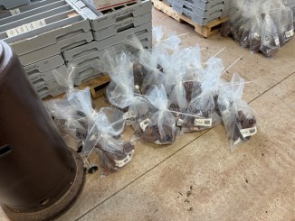 |
|
Figure 12-1 Samples selected for verification sampling
12.1 Verification Results
REO results from the verification samples were compared against the original REO values for each of the fifty-five (55) sample pairs (excluding the two CRM standards and two blanks). Relative percent difference (RPD) was calculated as
RPD = [ (Original - Verification) / Average] *100
Summary statistics are presented below and displayed in Figure 12-2 and Figure 12-3.
The mean absolute RPD across the verification samples was approximately 17% (Figure 12-2), consistent with expected analytical and sampling variability for the heterogeneous nature of carbonatite-hosted REE mineralization at the scale of one-meter sample intervals.
| Rift Project - Nebraska, USA |
Element by element review of the verification pairs demonstrated that the observed differences between the verification samples and original results were not a consequence of any single REE. Where larger RPD values were observed, the variation was seen as proportional across the full suite of REE, with Ce, La, Nd and Pr typically all moving by similar proportions. The REE ratios remained relatively consistent between the Author's analysis and the original analysis. These results are characteristics of small-scale natural variability in the REE distribution in carbonatite and does not indicate analytical bias or specific element interferences.
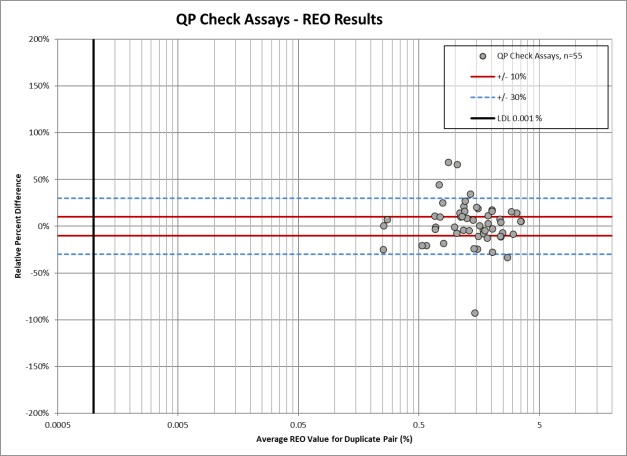
Figure 12-2 QP Verification Samples - Relative Percent Difference vs Average REO Value
| NI 43-101 Technical Report | |
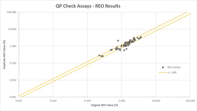
Figure 12-3 QP Verification vs Original Sample Results
12.2 Qualified Person Opinion
The Author is of the opinion that the sample preparation, analytical methods, security procedures, and QA/QC protocols employed during the data verification sampling program are consistent with industry standard practices and are suitable for the style of mineralization being investigated. The insertion and monitoring of certified reference materials, blanks, and duplicate samples, together with the internal laboratory QA/QC procedures implemented by Actlabs, provide confidence in the accuracy and precision of the analytical results. The check REE assays, sampled by the Author, correspond well with the original assays, with any variations within the expected range of natural variability for the style of mineralization. The Author considers the data and corresponding analytical results to be reliable and suitable for use in this Technical Report.
| Rift Project - Nebraska, USA |
13 Mineral Processing & Metallurgical Testing
No mineral processing or metallurgical testing has been completed on the Property by Apex or its affiliates.
| NI 43-101 Technical Report | |
14 Mineral Resource Estimate
No Mineral Resource Estimate has been completed on the Property.
| Rift Project - Nebraska, USA |
15 Item 15 to 22 Not Applicable (Early-Stage Property)
The Rift Project is an early-stage exploration project. Sections 15 to 22, as defined by NI 43-101, are not relevant to this report and have been omitted.
| NI 43-101 Technical Report | |
23 Adjacent Properties
The most significant adjacent property is the Elk Creek Project held by NioCorp(the "Adjacent Property"). In February 2026 NioCorp commenced construction of the portal (main mine entrance) to the underground portion of the deposit (NioCorp Developments Ltd., 2026).
A Feasibility Study completed in June 2022 details that NioCorp plans to produce three mineral products, niobium, scandium and titanium, from a single ore body that is also enriched in rare earths (Batty et al., 2022). The Feasibility Study is based on an assumption of processing 36,656 kilotonnes (kt) of ore over a 38-year life of mine (LOM) to produce 171,140 tonnes (t) of Nb in the form of ferroniobium, 3,676 tonnes of Sc2O3 and 431,793 tonnes of TiO2. Rare earths have been added to the Mineral Resource, and the Indicated Resource contains 632.9 kt of Total Rare Earth Oxide (TREO) at 0.34%. A breakdown of select elements is provided below:
This has been estimated using a ≥ US$180/tonne NSR cut-off that was calculated using solely the contained niobium, scandium, and titanium in the Mineral Resource. Initial capital costs are estimated at US$ 1,141 million. Total capital cost, inclusive of sustaining, closure/reclamation, and contingency costs is US$ 1,606 million. Total LOM operating costs are estimated to be US$ 7,182 million. Costs and product pricing are presented using a 2019 basis. On a pre-tax basis, the NPV (8% discount) is US$ 2,819 million, the IRR is 29.2%, and the assumed payback period is within 2.67 years. On a post-tax basis, the NPV (8% discount) is US$ 2,350 million, the IRR is 27.6%, and the assumed payback period is within 2.69 years.
The Elk Creek Niobium-Scandium-Titanium deposit is all hosted within the Elk Creek Carbonatite, the same carbonatite that hosts REE mineralization at the Rift Project. Niobium is contained primarily within the mineral pyrochlore, and REE mineralization is reported to occur as bastnäsite, parisite, synchysite and monazite. The Elk Creek Deposit (the "Deposit"), as defined in the Mineral Resource Estimate, consists of niobium, titanium, scandium and rare earth mineralization that is chiefly hosted within a magnetite (hematite) dolomite carbonatite.
The Author has been unable to verify the information pertaining to the Adjacent Property and the information is not necessarily indicative of the mineralization on the Property that is the subject of this Technical Report.
| Rift Project - Nebraska, USA |
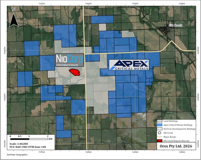
Figure 23-1 Adjacent Property Map
| NI 43-101 Technical Report | |
24 Other Relevant Data & Information
The Author is not aware of any other relevant data or information needed to make this Technical Report understandable and not misleading.
| Rift Project - Nebraska, USA |
25 Interpretation & Conclusions
The Rift Project is an early-stage exploration property within the Elk Creek carbonatite complex in Johnson and Pawnee Counties, Nebraska. Historical and recent exploration results show the Property is prospective for carbonatite-hosted REE and niobium mineralization. The geology, host rocks, alteration, and mineralization identified to date are consistent with a carbonatite-associated REE deposit model.
Historical exploration by Molycorp, Cominco, and NioCorp confirmed REE and niobium mineralization within the current Property boundary. Several historical drillholes, including EC-093 and NEC11-004, as well as 2026 drillholes have returned significant REO intercepts. These historical results provide a strong foundation for current exploration, although some historical sampling, analytical, and QA/QC records are incomplete by modern standards. In addition to the REE potential, drillholes EC-076 and EC-084 intersected elevated Nb2O5 in an area north of the current 2026 drill program, indicating niobium potential that warrants evaluation as a secondary commodity
The 2026 drilling program confirmed and expanded REE mineralization on the Property. All reported drillholes intersected significant carbonatite intervals, with REE mineralization closely associated with hematite alteration. Drilling has defined a high-grade upper REO horizon called the Trinity Zone, located near the top of the carbonatite beneath the sedimentary cover. The Trinity Zone has been intersected in multiple drillholes and remains open along strike and at depth.
Drilling also identified a deeper NdPr-enriched horizon called the Neo Zone. First identified in RIFT26-002 and expanded in RIFT26-003, the Neo Zone contains elevated NdPr distributions that are significantly higher than those typically reported in many carbonatite-hosted REE deposits. This zone represents an important exploration target that requires further drilling, metallurgical testing, and geological modelling.
The Author considers the 2025 and 2026 sampling, analytical methods, security procedures, and QA/QC protocols to be consistent with industry standard practices and suitable for this style of mineralization. The available assay database is considered reliable for this Technical Report. However, the Property does not currently contain a Mineral Resource or Mineral Reserve estimate, and the continuity, geometry, metallurgy, and economic potential of the mineralized zones have not yet been established.
Key risks include the early-stage nature of the Property, pending assay results from the 2026 drill program, the need for additional drilling, uncertainty regarding metallurgical recovery, deleterious elements, and the absence of resource, mining, processing, environmental, and economic studies. Continued phased exploration is recommended, with further advancement dependent on positive drilling, metallurgical, and geological results.
In the opinion of the Author, the Rift Project has sufficient geological merit to warrant continued systematic exploration. Results from the 2025 relogging and resampling program and the ongoing 2026 drill program confirm the presence of extensive REE mineralization associated with the Elk Creek carbonatite complex, including the near-surface Trinity Zone and the deeper NdPr-enriched Neo Zone. Advancement of the Property will require additional exploration as discussed in Section 26 (Recommendations).
| NI 43-101 Technical Report | |
26 Recommendations
The Author recommends that additional exploration work be conducted to advance the Property toward an initial Mineral Resource Estimate in accordance with NI 43-101 disclosure standards. Continued drilling and technical studies are warranted to evaluate the continuity, grade distribution, geometry, density characteristics, metallurgical response, and potential economic significance on the Property. Advancement to an initial Mineral Resource Estimate is contingent on continued positive drilling and metallurgical results. The recommended work should include:
Table 26-1 Estimated Budget for Proposed Work
| Item | Estimated Cost (USD) |
| Phase II Diamond Drilling (10,000 m) | $3,000,000 |
| Permitting Support | $100,000 |
| Downhole Surveys (OTV/ATV) | $150,000 |
| Geological Staffing, Core Logging & Technical Support | $900,000 |
| Rift Project - Nebraska, USA |
| Item | Estimated Cost (USD) |
| Assaying & Analytical Costs (includes QA/QC & Check analysis) | $725,000 |
| Metallurgical Sampling & Preliminary Metallurgical Testing | $150,000 |
| Initial NI 43-101 Mineral Resource Estimate & Technical Reporting | $125,000 |
| Travel, Accommodation & Field Logistics | $695,000 |
| Estimate Total | $5,845,000 |
| NI 43-101 Technical Report | |
27 References
Anzman, J. (1976). Interpretation of Gravity and Magnetic Data, Elk Creek Anomaly, Johnson and Pawnee Counties, Nebraska. Molycorp Inc., June 29, 1976, 22 pages.
Batty et al. (2022). NI 43-101 Technical Report Feasibility, Study Elk Creek Project, Nebraska, Prepared for NioCorp Developments Ltd.
Brookins, D. G., Treves, S. B., & Bolivar, S. L. (1975). Elk Creek, Nebraska, Carbonatite: Strontium Geochemistry.
Burberry, C. M., Joeckel, R. M., & Korus, J. T. (2016). Post-Mississippian tectonic evolution of the Nemaha Tectonic Zone and Midcontinent Rift System, SE Nebraska and N Kansas. The Mountain Geologist, 52(4), 47-73.
Burchett, R. (1982). Thickness and structure maps of the Pennsylvanian and Permian rocks across Southern Nebraska. Report of Investigations No. 7.
Burfeind, W. J., Carlson, M. P., & Smith, R. (1971). The Elk Creek geophysical anomaly, Johnson and Pawnee Counties, Nebraska. Geological Society of America Program Abstracts, 3 (4), p. 254.
Carlson, M. P. (1992). Tectonic implications and influence of the Midcontinent. Rift System in. In: (Richard W. Ojakangas, Albert B. Dickas, John C. Green, Eds. Basement tectonics 10: proceedings of the Tenth International Conference on Basement Tectonics, Duluth, MN.
Carlson, M. P., & Treves, S. B. (2005). The Elk Creek Carbonatite, Southeast Nebraska - An Overview. Natural Resources Research, 14(1).
Daigle, P. (2011). Resource Estimate and Technical Report for the Elk Creek Nb-REE Project, Nebraska, USA.
Farmer, J. D., Chamberlain, K. R., & Babcock, S. M. (2013). Final Technical Report for "Collaborative Research with the University of Nebraska and University of Colorado on the Age and Origin of the REE-Rich Elk Creek Carbonatite, Southeast Nebraska, USA. USGS Award Number G12AP20052.
Mitchell, R. (2005). Carbonatites and Carbonatites and Carbonatites. The Canadian Mineralogist, December 2005; v. 43(no. 6), p. 2049-2068.
NioCorp Developments Ltd. (2026, February 26). NioCorp Launches Construction of Elk Creek Critical Minerals Project Mine Portal. [Press Release]. Retrieved from News Release: https://www.niocorp.com/niocorp-launches-construction-of-elk-creek-critical-minerals-project-mine-portal/
Ojakangas, R. W., Morey, G. B., & Green, J. C. (2001). The Mesoproterozoic Midcontinent Rift System, Lake Superior Region, USA. Sedimentary Geology, 141-142, 421-442.
Paterman, K. (1985). Isotopic age data: U.S. Geological Survey Isotope Laboratory. unpublished data.
Richardson, D. G., & Birkett, T. C. (1996). Carbonatite-Associated Deposits. In O. R. Eckstrand, W. D. Sinclair, & R. I. Thorpe (Eds.), Geology of Canadian Mineral Deposit Types (Vol. 8, pp. 541-558). Ottawa, Ontario: Geological Survey of Canada.
| Rift Project - Nebraska, USA |
Shearer, R. L. (1985). Geochemistry of the +100' through -1,300' Elevation Levels, Elk Creek, Nebraska. Molycorp, Inc., Englewood, Colorado.
Tetra Tech. (2012). Quantum Rare Earth Developments Corp, Elk Creek Nb Project, Nebraska, US, Resource Estimate Update.
U.S. Geological Survey. (1973). Aeromagnetic map of southeastern Nebraska and parts of adjacent states. Open-File Report 73-297, USGS, Water Resources Division. doi:10.3133/ofr73297
Verplanck, P. L., Farmer, G. L., Kettler, R. M., Lowers, H. A., Johnson, C. A., Koenig, A. E., & Blessington, M. J. (2022). Petrogenesis and rare earth element mineralization of the Elk Creek carbonatite, Nebraska, USA. Ore Geology Reviews, 146, 19.
Verplanck, P. L., Van Gosen, B. S., Seal, R. R., & McCafferty, A. E. (2014). A Deposit Model for Carbonatite and Peralkaline Intrusion-Related Rare Earth Element Deposits. Scientific Investigations Report 2010-5070-J, U.S. Geological Survey.
Woolley, A. R., & Kempe, D. R. (1989). Carbonatites: nomenclature, average chemical compositions, and element distribution. In Carbonatites: Carbonatites: genesis and evolution (K. Bell, Ed.). Unwin Hyman, London, pp 1-14.
Woolley, A. R., & Kjarsgaard, B. A. (2008). Paragenetic types of carbonatite as indicated by the diversity and relative abundances of associated silicate rocks: evidence from a global database. The Canadian Mineralogist, vol. 46(no. 4), pp 741-752.
Xu, A. (1996). Mineralogy, Petrology, Geochemistry and Origin of the Elk Creek Carbonatite, Nebraska. University of Nebraska-Lincoln, Lincoln, Nebraska.
| NI 43-101 Technical Report | |
28 Date & Signature Page
This report entitled, "NI 43-101 Technical Report on the Rift Project, Johnson and Pawnee Counties, Nebraska, USA" and with an effective date of May 15, 2026 and a signature date of June 12, 2026, was prepared on behalf of Apex Critical Metals Corp. and is signed by the Author.
_____________________________________
Robin J. Wilson
B.Sc. (Hons) Geology, MAusIMM, MAIG
56 Arnott Street, Trigg, Western Australia 6029, Australia
June 12, 2026
| Rift Project - Nebraska, USA |
29 Certificate of Qualified Person
I, Robin J. Wilson, B.Sc. (Hons) Geology, MAUSIMM, MAIG, do hereby certify that:
1) I am employed as a Principal Geologist with Orex Pty Ltd, at 56 Arnott Street, Trigg, WA 6029, Australia.
2) This certificate applies to the report entitled "NI 43-101 Technical Report on the Rift Project" (the "Technical Report"), prepared on behalf of Apex Critical Metals Corp. ("Apex"), and with an effective date of May 15, 2026 and signature date of June 12, 2026.
3) I graduated with a B.Sc. (Hons) Geology from Nottingham University, United Kingdom in 1987.
4) I am a Member of the Australian Institute of Mining and Metallurgy (No. 109079) and a Member of the Australian Institute of Geoscientists (No. 2659).
5) I have practiced my profession as a geologist over two continuous periods for a total of 32 years during which time I have been involved in mineral exploration for precious metals, base metals and critical minerals, including rare earth elements (REE).
6) I have read the definition of a qualified person ("QP") as set out in National Instrument 43-101 - Standards of Disclosure for Mineral Projects ("NI 43-101") and certify that by reason of my education, affiliation with a professional association (as defined by NI 43-101) and past relevant work experience, I fulfill the requirements to be a QP for the purposes of NI 43-101.
7) I personally inspected the Rift Project on March 6, 2026 for the duration of one day.
8) I am responsible for the preparation and take responsibility for all sections of the Technical Report.
9) I am independent of Apex as determined under Section 1.5 of NI 43-101.
10) I have not had prior involvement with the Property that is the subject of this Technical Report, other than in connection with my March 6, 2026 site visit noted above.
11) I have read NI 43-101 and all items of the Technical Report have been prepared in compliance with this Instrument.
12) As of the Effective Date of this Technical Report, May 15, 2026, to the best of my knowledge, information and belief, this Technical Report contains all scientific and technical information that is required to be disclosed to make the Technical Report not misleading.