 |
Page | i |
| Cap Property - BC, Canada |
NI 43-101 Technical Report on the
Cap Property
BC, Canada
| Prepared For: | Apex Critical Metals Corp. |
| 1450 - 789 West Pender St | |
| Vancouver, BC, Canada |
Author: Jeremy Hanson, P. Geo.
Effective Date: July 31, 2026
Signature Date: July 31, 2026
|
Page | i |
| NI 43-101 Technical Report | Apex Critical Metals Corp. |
Table of Contents
| 1 Executive Summary | 2 |
| 1.1 Property Description | 2 |
| 1.2 Mineral Tenure | 2 |
| 1.3 Geology and Mineralization | 2 |
| 1.4 Exploration | 2 |
| 1.5 Mineral Resource & Mineral Reserve Estimates | 3 |
| 1.6 Development & Operations | 3 |
| 1.7 Conclusions & Recommendations | 3 |
| 1.8 Risks | 4 |
| 2 Introduction | 5 |
| 3 Reliance on Experts | 6 |
| 4 Property Description & Location | 7 |
| 4.1 Property Location | 7 |
| 4.2 Mineral Tenure | 8 |
| 4.3 Environmental Liabilities | 11 |
| 4.4 Required Permits | 11 |
| 4.5 Other Significant Factors or Risks | 11 |
| 5 Accessibility, Local Resources, Infrastructure, Physiography & Climate | 14 |
| 5.1 Physiography | 14 |
| 5.2 Climate | 14 |
| 5.3 Accessibility | 14 |
| 5.4 Local Resources & Infrastructure | 15 |
| 6 History | 17 |
| 6.1 Prior Ownership | 17 |
| 6.2 Previous Exploration & Development | 17 |
| 7 Geological Setting & Mineralization | 20 |
| 7.1 Regional Geology | 20 |
| 7.2 Local & Property Geology | 23 |
| 7.3 Mineralization | 25 |
|
Page | ii |
| Cap Property - BC, Canada |
| 8 Deposit Type | 26 |
| 9 Exploration | 27 |
| 9.1 2023 Rock Sampling | 27 |
| 9.2 2024 Rock, Soil and Stream Concentrate Sampling | 27 |
| 9.3 2024 Drone LiDAR and Photogrammetry | 33 |
| 9.4 Airborne Magnetic and Radiometric Survey | 33 |
| 10 Drilling | 36 |
| 10.1 2025 Drill Results | 38 |
| 10.2 2026 Drill Results | 41 |
| 10.3 Structure | 42 |
| 11 Sample Preparation, Analysis & Security | 43 |
| 11.1 Pre-Analysis Sample Preparation and Quality Control | 43 |
| 11.2 Laboratory Sample Preparation & Analysis | 44 |
| 11.3 Quality Control & Quality Assurance | 45 |
| 11.3.1 Blanks | 45 |
| 11.3.2 Certified Reference Materials | 46 |
| 11.3.3 Pulp and Coarse Reject Duplicates | 49 |
| 12 Data Verification | 51 |
| 13 Mineral Processing & Metallurgical Testing | 52 |
| 14 Mineral Resource Estimate | 53 |
| 15 to 22 Not Applicable | 54 |
| 23 Adjacent Properties | 55 |
| 24 Other Relevant Data & Information | 57 |
| 25 Interpretation & Conclusions | 68 |
| 26 Recommendations | 69 |
| 27 References | 71 |
| 28 Date & Signature Page | 73 |
| 29 Certificate of Qualified Person | 74 |
|
Page | iii |
| NI 43-101 Technical Report | Apex Critical Metals Corp. |
List of Tables
| Table 4-1 | Mineral Tenure Work Requirements and Cash-in-lieu payments in BC | 8 |
| Table 4-2 | Cap Property Mineral Tenure List | 9 |
| Table 6-1 | Summary of Historical Exploration | 18 |
| Table 7-1 | Stratigraphic Units in the Monkman Pass Area | 20 |
| Table 9-1 | 2024 Rock Sampling - Select Assay Results | 28 |
| Table 10-1 | Drillhole Locations and Attributes | 37 |
| Table 10-2 | Summary of Select Drill Results - 2025 Drill Program | 40 |
| Table 11-1 | 2025 Drill Program - Silica Blank Results Summary | 46 |
| Table 11-2 | Certified reference material results with CDN-RE-1201 | 47 |
| Table 11-3 | Certified reference material results with CDN-RE-1202 | 47 |
| Table 11-4 | Certified reference material results with CDN-RE-1203 | 48 |
| Table 11-5 | Certified reference material results with OREAS 465b | 48 |
| Table 24-1 | Element-to-Oxide Conversion Factors | 57 |
| Table 24-2 | Individual REO Component Disclosure - 2024 Surface Rock Samples | 58 |
| Table 24-3 | Individual REO Component Disclosure - 2024 Stream Concentrate Samples | 59 |
| Table 24-4 | Individual REO Component Disclosure - Grid 1 to Grid 3 - 2024 Soil Samples | 60 |
| Table 24-5 | Individual REO Component Disclosure - 2025 Drill Assays | 67 |
| Table 26-1 | Estimated Budget for Proposed Work | 70 |
List of Figures
| Figure 4-1 | Cap Property Location Map | 7 |
| Figure 4-2 | Cap Property Mineral Tenure Map | 10 |
| Figure 4-3 | Property Restrictions and Protections | 13 |
| Figure 5-1 | Cap Property Access Map | 16 |
| Figure 6-1 | Historical Exploration Map | 19 |
| Figure 7-1 | Regional Geology | 22 |
| Figure 7-2 | Property Geology | 24 |
| Figure 9-1 | 2023-2024 Surface Rock Samples - Nb₂O₅% and REO% | 29 |
| Figure 9-2 | 2024 Stream Concentrate Samples - Nb₂O₅% and REO% | 30 |
| Figure 9-3 | Grid 1 - 2024 Soil Samples - Nb (ppm) and REO (%) | 31 |
| Figure 9-4 | Grid 2 - 2024 Soil Samples - Nb (ppm) and REO (%) | 32 |
| Figure 9-5 | Grid 3 - 2024 Soil Samples - Nb (ppm) and REO (%) | 33 |
| Figure 9-6 | 2025 Airborne Geophysical Survey - Total Magnetic Intensity | 34 |
| Figure 9-7 | 2025 Airborne Geophysical Survey - Thorium | 35 |
| Figure 10-1 | 2025 and 2026 Drillhole Location Map | 38 |
| Figure 11-1 | Pulp duplicate and original samples - TREE + Y (ppm) | 49 |
| Figure 11-2 | Coarse Reject duplicate and original samples - TREE + Y (ppm) | 50 |
| Figure 23-1 | Adjacent Property Map | 56 |
|
Page | iv |
| Cap Property - BC, Canada |
Abbreviations
|
Abbreviations |
Definition |
|
° |
degree |
|
°C |
degrees Celsius |
|
m |
metre |
|
km |
kilometre |
|
ha |
hectare |
|
CAD |
Canadian Dollars |
|
ppm |
parts per million |
|
ppb |
parts per billion |
|
% |
percent |
|
GPS |
Global Positioning System |
|
UTM |
Universal Transverse Mercator |
|
NAD83 |
North American Datum 1983 |
|
NTS |
National Topographic System |
|
REE |
Rare Earth Elements |
|
REO |
Rare Earth Oxide |
|
TREE+Y |
Total Rare Earth Elements + Yttrium |
|
DDH |
Diamond Drillhole |
|
NQ |
NQ Core Size |
|
SG |
Specific Gravity |
|
XRF |
X-ray Fluorescence |
|
ICP-MS |
Inductively Coupled Plasma Mass Spectrometry |
|
CPS |
Counts Per Second |
|
LiDAR |
Light Detection and Ranging |
|
TMI |
Total Magnetic Intensity |
|
EM |
Electromagnetic |
|
QA/QC |
Quality Assurance / Quality Control |
|
CRM |
Certified Reference Material |
|
MTO |
Mineral Titles Online |
|
FMC |
Free Miner Certificate |
|
NSR |
Net Smelter Return |
|
NoW |
Notice of Work |
|
MYAB |
Multi-Year Area-Based Permit |
|
BC MEMPR |
BC Ministry of Energy, Mines and Petroleum Resources |
|
GSC |
Geological Survey of Canada |
| NI 43-101 Technical Report | Apex Critical Metals Corp. |
1 Executive Summary
Apex Critical Metals Corp. ("Apex" or the "Company") has retained Jeremy Hanson, P.Geo. (the "Author"), to prepare an independent Technical Report on the Cap Property (the "Cap Property" or "Property"), located in BC, Canada. This report (the "Report" or "Technical Report") has been prepared in compliance with regulatory disclosure and reporting requirements as outlined in Canadian National Instrument 43-101 - Standards for Disclosure for Mineral Projects ("NI 43-101"), companion policy NI 43-101CP and Form 43-101F1 - Technical Report.
The purpose of this Report is to provide an updated and compliant technical summary of the Cap Property, British Columbia, including geology, exploration history, exploration results, and mineralization
1.1 Property Description
The Cap Property is located approximately 80 km northeast of Prince George, British Columbia, centered on 54°23'40"N, 121°44'17"W within NTS map sheet 93I/05. The Property is accessible via provincial highways and forestry roads to its southern portion, with helicopter support required for access to the primary exploration area due to rugged alpine terrain.
1.2 Mineral Tenure
The Cap Property consists of six contiguous mineral claims (CAP 1 through CAP06) covering 2,824.3 ha. All claims are in good standing until October 24, 2031, and are 100% registered to Apex Critical Metals Corp.
A 2% Net Smelter Return (NSR) royalty applies to five of the six claims (CAP 1-CAP 5); CAP06 is royalty-free. The Property is covered by an active Mines Act Permit (MX-11-251) authorizing multi-year exploration, including up to 60 drill sites, 20 helipads, and two laydown areas and valid until December 5, 2029.
1.3 Geology and Mineralization
The Cap Property hosts a carbonatite-related intrusive system referred to as the Cap Carbonatite Complex. Mineralization is associated with carbonatite and fenite-altered intrusive rocks and is characterized by niobium enrichment, locally accompanied by phosphate and rare earth elements (REE). Historical drilling in 2017 confirmed subsurface carbonatite-hosted mineralization, and recent drilling in 2025 and 2026 demonstrated lateral continuity of the system.
1.4 Exploration
Exploration on the Cap Property and surrounding area dates back to 2010, when early reconnaissance sampling and airborne geophysical surveys identified magnetic and radiometric anomalies coincident with the current property. Follow-up work by Arctic Star Exploration Corp. in 2011 refined a strong central magnetic anomaly and returned surface samples grading up to 0.27% Nb₂O₅. In 2017, Arctic Star completed prospecting and a four-hole diamond drill program totaling 647.5 m, confirming subsurface carbonatite-hosted mineralization in drillhole CAP17-004, which intersected intervals up to 10.42 m averaging 0.35% Nb₂O₅. These results established the presence of a carbonatite system and guided subsequent exploration by Apex Critical Metals Corp.
|
Page | 2 |
| Cap Property - BC, Canada |
Between 2023 and 2026, Apex advanced the Property through systematic exploration programs, including geological mapping, geochemical sampling, drone LiDAR and photogrammetry, airborne magnetic and radiometric surveys, and diamond drilling. Surface sampling in 2024 returned rock assays up to 3.33% Nb₂O₅, with associated phosphate and rare earth element enrichment, and outlined a 1.8 km niobium soil anomaly coincident with historical geophysical anomalies.
In 2025, Apex completed nine (9) NQ diamond drillholes totaling 2,323 m. The most significant intersection returned was from CAP25-006, which returned 124.5 m averaging 0.27% Nb₂O₅, including 10.0 m at 1.08% Nb₂O₅. Additional drillholes confirmed phosphate enrichment and localized REE mineralization, demonstrating lateral continuity of the Cap Carbonatite Complex and identifying new targets for follow-up drilling.
In 2026, Apex completed a follow-up program comprising three NQ drillholes totalling 1,072 m. CAP26-014 and CAP26-015, collared from the same pad as CAP25-006, intersected carbonatite and fenite from near surface to end of hole. CAP26-016 targeted the prominent magnetic anomaly at depth and intersected predominantly metasedimentary lithologies; the source of the anomaly was not identified. Assay results from the 2026 program are pending as of the effective date of this Report.
1.5 Mineral Resource & Mineral Reserve Estimates
No mineral resource or reserve estimates have been completed for the Property.
1.6 Development & Operations
No significant development of the Property or significant operations have been conducted on the Cap Property.
1.7 Conclusions & Recommendations
Exploration results confirm the presence of a multi-phase carbonatite system with potential for niobium and REE mineralization. Integration of geochemical, drilling, and geophysical data suggests the Cap Carbonatite Complex has potential to be part of a broader intrusive system. The prominent magnetic anomaly remains underexplored, with the source yet to be identified. Recommendations include more detailed investigation of existing geophysical datasets to further refine drill targets.
Further exploration is warranted, including:
|
Page | 3 |
| NI 43-101 Technical Report | Apex Critical Metals Corp. |
1.8 Risks
The Cap Property is an early-stage exploration project. There is no guarantee that current or future exploration will result in an economic orebody. In addition to technical and economic uncertainties, exploration activities are subject to environmental and regulatory constraints, including seasonal work restrictions related to Mountain Caribou habitat and other wildlife mitigation measures. These factors may influence scheduling and costs but can be managed through compliance with permit conditions and proactive planning.
|
Page | 4 |
| Cap Property - BC, Canada |
2 Introduction
Apex Critical Metals Corp. ("Apex" or the "Company") has retained Jeremy Hanson of Hardline Exploration Corp. (the "Author") to prepare an independent Technical Report on the Cap Property (the "Cap Property" or "Property"), located in BC, Canada. The Property consists of six (6) contiguous mineral claims covering 2,824.3 ha. Apex holds 100% interest in the Property and is the registered titled holder as recorded in the British Columbia Mineral Titles Online (MTO) system.
This Technical Report has been prepared in compliance with regulatory disclosure and reporting requirements as outlined in Canadian National Instrument 43-101 - Standards for Disclosure for Mineral Projects ("NI 43-101"), companion policy NI 43-101CP and Form 43-101F1 - Technical Report. The Qualified Person responsible for this Report is Jeremy Hanson, P.Geo.
The purpose of this Report is to provide an updated and compliant technical summary of the Cap Property, British Columbia, including geology, exploration history, exploration results, and mineralization. This Report has been prepared to ensure that technical disclosure relating to the Cap Property conforms with current regulatory standards and reflects recent exploration activities completed by the Company. The Report supersedes and replaces prior technical disclosure for the Property.
Information, conclusions, and recommendations contained within this Report are based on field observations, as well as published and unpublished data (Section 27; References) available to the Author at the time of preparing this Report.
The Author visited the Cap Property on July 18, 2026. During this visit, the Author observed drill core, alteration styles, carbonatite-hosted mineralization from 2025 drilling, reviewed core processing and storage facilities and inspected drill collars.
Additional data verification for recent work was completed through detailed review of geological logging procedures, drill core photographs, analytical results, and quality assurance and quality control data, as described in Section 12 of this Report. In the Author's opinion, this level of verification is appropriate for the stage of exploration and provides sufficient confidence in the data presented herein.
|
Page | 5 |
| NI 43-101 Technical Report | Apex Critical Metals Corp. |
3 Reliance on Experts
This Report has been prepared for Apex Critical Metals Corp. by Jeremy Hanson, P.Geo. The information, conclusions, opinions, and estimates contained herein are based on assumptions, conditions, and qualifications as set forth in this Report.
The Author has relied on statements and documents provided by the Company concerning legal matters which are discussed in Sections 4.2, 4.3 and 4.4 of this Report. These items include location of land holdings, status of land holdings and royalty and purchase agreements relating to the land holdings and concessions. For the purpose of this Report, the Author has relied on registered title information downloaded from BC Mineral Titles Online (MTO). The information was last accessed on July 31st, 2026. While title information was reviewed for this Report, it does not constitute, nor is it intended to represent legal, or any other opinion to title.
Except for these specific legal matters noted above, the Author is fully responsible for all scientific and technical information contained in this Technical Report.
As of the date of this Report, the Author is not aware of any material fact or material change with respect to the subject matter of this Report, in its entirety, that is not presented herein or which the omission to disclose could make this Report misleading.
|
Page | 6 |
| Cap Property - BC, Canada |
4 Property Description & Location
4.1 Property Location
The CAP Property is located approximately 80 km northeast of Prince George, British Columbia (Figure 4-1). The Property is centered on 54°23'40"N, 121°44'17"W and falls within National Topographic System (NTS) map sheet 93I/05.
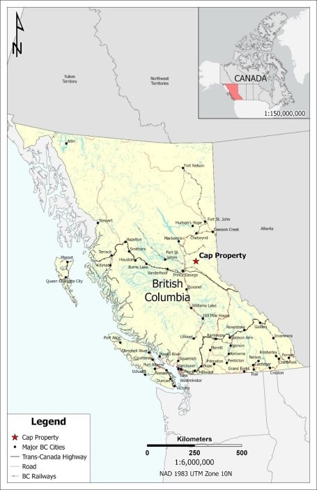
Figure 4-1 Cap Property Location Map
|
Page | 7 |
| NI 43-101 Technical Report | Apex Critical Metals Corp. |
4.2 Mineral Tenure
In British Columbia, mineral claims (mineral tenures) grant the holder the exclusive right to explore for minerals within the boundaries of the tenure. Mineral claims allow for the extraction of up to 1,000 tonnes of mineralized material per year without requiring conversion to a mineral lease; however, all exploration and extraction activities remain subject to permitting requirements under the Mines Act and other applicable provincial legislation. Extraction of material in excess of this amount, or activities constituting commercial production, generally require the acquisition of a mineral lease.
Surface access for exploration activities is regulated under applicable provincial legislation, including the Mines Act, and requires appropriate permits and authorizations. The Company has obtained the permits required to conduct its proposed exploration activities, as discussed in Section 4.4 (Required Permits) of this Report.
Mineral claims are governed by the British Columbia Mineral Tenure Act and are acquired and administered through the online mineral title registry, Mineral Titles Online (MTO). A Free Miner Certificate (FMC) is required to acquire and maintain mineral claims and is available to both individuals and corporations through MTO.
Mineral claims may be held for an unlimited duration, provided they are maintained in good standing. To maintain a claim, the holder must either complete and record a minimum amount of eligible exploration and development work per hectare each year or make a corresponding cash-in-lieu payment. The annual work requirements and cash-in-lieu amounts, which increase with each anniversary year, are summarized in Table 4-1.
Table 4-1 Mineral Tenure Work Requirements and Cash-in-lieu payments in BC
|
Anniversary Year |
Work Requirement |
Cash-In-Lieu |
|
1 and 2 |
$5/hectare |
$10/hectare |
|
3 and 4 |
$10/hectare |
$20/hectare |
|
5 and 6 |
$15/hectare |
$30/hectare |
|
7 and subsequent |
$20/hectare |
$40/hectare |
The Cap Property consists of six (6) contiguous mineral claims (CAP 1 through CAP06) covering a total area of 2,824.3 ha (Table 4-2, Figure 4-2). The mineral tenures are all in good standing and are 100% registered to Apex Critical Metals Corp. The mineral tenure information presented in this report was last accessed from BC Mineral Titles Online (MTO) on July 31st, 2026.
The claims were originally acquired by Apex's predecessor company, Eagle Bay Resources Corp., pursuant to an agreement completed in February 2019 with Arctic Star Exploration Corp. At the time of acquisition, the Cap Property comprised twenty-one (21) mineral claims covering approximately 10,481.7 hectares. Following the acquisition, Eagle Bay Resources Corp. (now Apex Critical Metals Corp.) undertook periodic claim management, resulting in the expiry or abandonment of certain claims. The Property is currently comprised of six (6) contiguous mineral claims totaling 2,824.3 ha. A detailed history of property ownership and tenure acquisition is provided in Section 6.1.
|
Page | 8 |
| Cap Property - BC, Canada |
As part of the original purchase agreement between 877384 Alberta Ltd. ("877384") and Zimtu Capital Corp. ("Zimtu"), with Arctic Star Exploration Corp., the vendors (877384 and Zimtu) retain an aggregate 2% net smelter return ("NSR") royalty. The NSR applies to five (5) of the six (6) current claims (CAP 1 through CAP 5); CAP06 is not subject to the NSR.
Table 4-2 Cap Property Mineral Tenure List
| Tenure Number |
Claim Name |
Issue Date | Good to Date |
Owner Name | Area (ha) |
| 662403 | CAP 1 | 30-Oct-2009 | 24-Oct-2036 | APEX CRITICAL METALS CORP. | 470.6 |
| 662423 | CAP 2 | 30-Oct-2009 | 24-Oct-2036 | APEX CRITICAL METALS CORP. | 470.7 |
| 662424 | CAP 3 | 30-Oct-2009 | 24-Oct-2036 | APEX CRITICAL METALS CORP. | 470.9 |
| 662425 | CAP 4 | 30-Oct-2009 | 24-Oct-2036 | APEX CRITICAL METALS CORP. | 470.9 |
| 662443 | CAP 5 | 30-Oct-2009 | 24-Oct-2036 | APEX CRITICAL METALS CORP. | 470.8 |
| 1048033 | CAP06 | 24-Nov-2016 | 24-Oct-2036 | APEX CRITICAL METALS CORP. | 470.5 |
|
Page | 9 |
| NI 43-101 Technical Report | Apex Critical Metals Corp. |
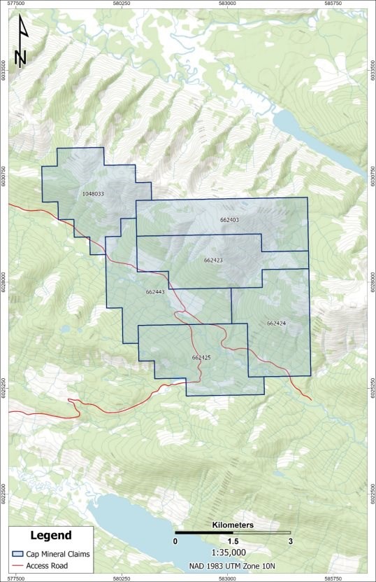
Figure 4-2 Cap Property Mineral Tenure Map
|
Page | 10 |
| Cap Property - BC, Canada |
4.3 Environmental Liabilities
The Qualified Person is not aware of any known environmental liabilities associated with the Property. The Property has not been subject to historical mining or production activities, and there are no known mine workings, tailings, waste rock piles, or other legacy issues that would be expected to give rise to environmental liabilities.
4.4 Required Permits
In British Columbia, mineral exploration activities that result in ground disturbance including drilling, trenching, construction of access trails, helipads, laydown areas, and fuel storage require authorization under the Mines Act in the form of a Notice of Work ("NoW") Permit. The Property is currently covered by an active Mines Act Permit (Permit No. MX-11-251; Mine No. 1641062) issued to Apex, with an original issuance date of March 25, 2012, most recently amended on December 6, 2024, and valid until December 5, 2029.
The permit authorizes a multi-year, area-based (MYAB) exploration program, including surface diamond drilling at up to sixty (60) drill sites, construction of up to twenty (20) helipads, establishment of two (2) laydown areas for a total approved disturbance footprint of approximately 1.74 ha. Bulk fuel storage of up to 16,000 litres is also authorized under the permit. A Free Use Permit issued under the Forest Act authorizes the cutting and use of up to 50 m³ of Crown timber within the permitted area to facilitate exploration activities approved under the Mines Act permit. A reclamation security in the amount of $43,000 has been posted with the Province of British Columbia to ensure compliance with the approved reclamation program.
All permitted activities are subject to detailed environmental protection, wildlife mitigation, cultural heritage, health and safety, and reclamation conditions as outlined in the approved Mine Plan and Reclamation Program. Any exploration activities proposed outside the scope of the existing permit would require a permit amendment or additional authorization prior to commencement.
4.5 Other Significant Factors or Risks
The Property is located within the asserted traditional territories of the Lheidli T'enneh First Nation and the McLeod Lake Indian Band. Initial engagement and consultation with these First Nations were completed as part of the 2025 permit amendment process, and continued engagement will remain an important consideration as exploration activities advance.
Much of the Property lies within identified Mountain Caribou habitat, and exploration activities are subject to timing restrictions and wildlife protection measures. The existing Mines Act Permit includes conditions governing seasonal work windows, aircraft separation distances, wildlife encounter protocols, and requirements for wildlife mitigation and monitoring where activities occur outside designated low-risk timing windows.
Portions of the Property overlap areas mapped as Old Growth Management Areas (OGMA) and other forest values, including stands exceeding 200 years of age. Exploration activities within or adjacent to these areas are subject to additional planning, mitigation, and avoidance measures.
A small portion of the Property, located at the northern part of the CAP 1 claim (tenure no. 662403), overlaps with Arctic Pacific Lakes Provincial Park (Figure 4-3). While mineral tenure exists in these isolated areas, the Crown does not grant mineral rights within lands already designated as a provincial park. As outlined in sections 11 and 21 of the Mineral Tenure Act, exploration or development activities within a provincial park are prohibited unless expressly authorized by the Lieutenant Governor in Council. The current permitted exploration activities do not authorize disturbance within the provincial park.
|
Page | 11 |
| NI 43-101 Technical Report | Apex Critical Metals Corp. |
Carbonatite-hosted mineral systems can locally contain elevated uranium and thorium as accessory elements. Uranium and thorium have not been analyzed by the Company as part of the 2023 to 2025 exploration programs on the Property as they are not target commodities. British Columbia maintains a provincial moratorium on the exploration and development of uranium as a primary commodity; however, it is acknowledged that uranium and thorium may be incidentally encountered during exploration for other minerals, which is managed through applicable Health, Safety and Reclamation Code requirements rather than prohibiting non-uranium projects.
No uranium-specific permitting or regulatory requirements have been triggered by exploration activities to date. Should the Project advance to more advanced studies, analysis for uranium and thorium is recommended for environmental and worker-safety considerations.
Other than the NSR royalty outlined in Section 4.2, and to the best of the Company's and the Qualified Person's knowledge, the Cap Property is not subject to any additional royalties, back-in rights, option agreements, earn-in arrangements, payments, or other material encumbrances that would affect the Company's interest in the mineral claims.
The Qualified Person is not aware of any additional significant factors or risks that would materially affect access, title, or the ability to carry out exploration work on the Cap Property.
|
Page | 12 |
| Cap Property - BC, Canada |
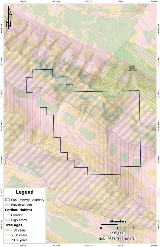
Figure 4-3 Property Restrictions and Protections
|
Page | 13 |
| NI 43-101 Technical Report | Apex Critical Metals Corp. |
5 Accessibility, Local Resources, Infrastructure, Physiography & Climate
5.1 Physiography
The Cap Property comprises mountainous terrain with rolling hills and locally swampy valleys. Slopes range from moderate to very steep, and ridge crests support mature sub-alpine and alpine forest dominated by alpine fir, hemlock, spruce, and white pine in unlogged areas. Previously logged areas are characterized by stands of immature pine and alder, while lower elevations commonly support dense underbrush vegetation, including buckbrush, alder, and devil's club.
Historical forestry activity, including clear-cut harvesting conducted approximately in 2010, is estimated to affect less than 10% of the Cap Property. Elevations across the Property range from approximately 950 m in valley bottoms to 1,826 m at Mount Kunchese in the northern portion of the Property. Bedrock outcrop is generally limited due to widespread glacial cover and surficial deposits.
5.2 Climate
The Cap Property is located within a mountainous continental climate typical of central British Columbia, characterized by long, cold winters and short, cool to mild summers. Climate conditions vary significantly with elevation, with alpine and sub-alpine areas experiencing lower temperatures, higher snowfall, and longer snow-cover duration than valley bottoms.
Winter conditions generally occur from November through April, with substantial snowfall and persistent snowpack at higher elevations. Summer conditions are relatively short, extending from June through September, and are characterized by moderate daytime temperatures and periodic precipitation. Summer daytime temperatures range from approximately 10°C to 25°C, while winter temperatures range from approximately -5°C to -20°C, with colder conditions occurring at higher elevations.
Weather conditions on the Property can change rapidly, particularly at higher elevations, and localized fog, wind, and storm events are common. Snow cover may persist into late spring or early summer in alpine areas, and seasonal factors such as spring breakup, snowpack, and precipitation can influence access and exploration scheduling. As a result, the typical operating season for exploration on the Property is approximately late May through October, subject to caribou-related timing restrictions, elevation, access method, and permitting constraints.
5.3 Accessibility
The Cap Property is accessible from Prince George via a network of provincial highways and forestry roads that provide regional access to the area (Figure 5-1). Forestry roads extend into the southern portion of the Property, allowing ground access to peripheral and lower-elevation areas.
Due to steep terrain, rugged alpine conditions, and mountain drainage valleys, the primary exploration area is not accessible by road and is accessed by helicopter support. Exploration programs targeting the area of interest are expected to rely primarily on helicopter-support, including personnel transport, equipment movement, and drill access. The 2023 and 2024 exploration programs completed by Apex were based out of Prince George, BC. The 2025 diamond drilling program was staged from Parsnip Camp, a road-accessible remote logging camp located approximately 35 km north of the Property, which provided accommodation, core logging facilities, and logistical support.
|
Page | 14 |
| Cap Property - BC, Canada |
5.4 Local Resources & Infrastructure
The nearest major population centre to the Cap Property is Prince George, located approximately 85 km southwest of the Property, and serves as the primary regional service and supply hub (Figure 5-1). Prince George provides a full range of infrastructure and services relevant to mineral exploration, including accommodation, food and fuel supplies, equipment rental and supply companies, transportation services, and skilled labour, as well as medical facilities and emergency services.
The region benefits from well-developed forestry and resource-sector infrastructure, including maintained highways, active and decommissioned logging roads, and established logistics corridors. Helicopter charter services capable of supporting exploration drilling and personnel transport are readily available in Prince George and are commonly used for exploration programs in mountainous terrain.
Electrical power, rail infrastructure, and telecommunications networks are present in the broader region; however, no permanent infrastructure is located directly on the Property. Exploration activities are expected to rely on temporary field camps, portable communications systems, and generator-based power supplies where required. Several small creeks and tributaries are present on and in the vicinity of the Cap Property and provide potential sources of water for exploration activities, including drilling. Surface water availability is seasonal and variable, with higher flows typically occurring during spring snowmelt and early summer, and reduced flows later in the summer and during winter months.
Potential tailings storage areas, waste disposal areas, heap leach pad locations, and processing plant sites have not been identified or evaluated, as the Cap Property remains at an early stage of exploration and such assessments are not warranted at this time.
|
Page | 15 |
| NI 43-101 Technical Report | Apex Critical Metals Corp. |
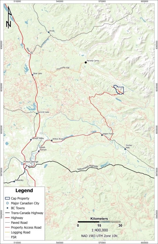
Figure 5-1 Cap Property Access Map
|
Page | 16 |
| Cap Property - BC, Canada |
6 History
6.1 Prior Ownership
The following summary describes the acquisition and ownership history of the historical Cap Property, which at various times comprised a substantially larger mineral claim package than the current Cap Property described in Section 4.2.
Between 2009 and 2010, Spectrum Mining Corp. acquired two groups of mineral claims in the vicinity of Wicheeda Lake. The southern group of these claims was referred to as the Wicheeda South Property. Portions of Spectrum's southern claim group overlapped areas that were later incorporated into the historical Cap Property, including claims identified as CAP 13, CAP 15, and CAP 16, which are no longer part of the current Cap Property.
In 2009, Jody Dahrouge staked five (5) mineral claims; CAP 1, CAP 2, CAP 3, CAP 4, and CAP 5, located southeast of the Wicheeda South Property. These claims were staked on behalf of, and held in trust for, 877384 Alberta Ltd. ("877384") and Zimtu Capital Corp.
In 2010, Arctic Star Exploration Corp. (known as Arctic Star Diamond Corp. until July 2011) entered into an option agreement to acquire a 100% interest in the CAP claims (CAP 1 through CAP 5), which it subsequently completed. During the same period, Bolero Resources Corp. acquired a large number of mineral claims in the surrounding region, collectively referred to as the Carbonatite Syndicate Property. Several of Bolero's historical claims overlapped portions of the historical Cap Property; however, these claims are not part of the current Cap Property.
In 2013, Damon Capital Corp. entered into an option agreement with Arctic Star to acquire a 75% joint venture interest in the historical Cap Property. Damon Capital Corp. did not satisfy the terms of the agreement, and the option was not completed.
Between 2010 and 2014, additional mineral claims staked by third parties, including Ken Smith, Jervin Werbes, David Heyman, and Clifford Brown, which all overlapped portions of the historical Cap Property. These claims were subsequently allowed to lapse, were otherwise terminated, or no longer overlap the current Cap Property.
In July 2017, Jody Dahrouge staked an additional sixteen (16) mineral claims (CAP06 and CAP 7 through CAP 21) on behalf of Arctic Star Exploration Corp., expanding the historical Cap Property claim package. Subsequent claim management and tenure reduction resulted in the expiry or abandonment of several of these claims.
The current Cap Property consists of six (6) contiguous mineral claims (CAP 1 through CAP 5 and CAP06), as described in Section 4.2.
6.2 Previous Exploration & Development
Historical exploration within the area of the Cap Property forms part of a broader exploration history associated with the historical Cap Property and surrounding claim groups. Exploration programs conducted between 2009 and 2017 included regional and property-scale geophysical surveys, reconnaissance- to detailed-scale surface geochemical sampling, and diamond drilling. A summary of selected historical exploration and development activities completed on the Property is outlined in Table 6-1 and Figure 6-1.
|
Page | 17 |
| NI 43-101 Technical Report | Apex Critical Metals Corp. |
Table 6-1 Summary of Historical Exploration
| Year | Operator | Work Performed | Key Results | Source |
| 2010 | Zimtu Capital Corp. | Reconnaissance sampling: 6 stream, 19 soil, 11 rock samples | Elevated REE/Nb noted in alkaline dykes; no economic concentrations encountered | (Hoffman & Kluczny, 2010) |
| 2010 | Bolero Resources Corp. | 31 stream‐silt samples along west side of CAP | Silts showed no notable anomalies | (Turner, 2011) |
| 2010 | Bolero Resources Corp. | AeroTEM III + Radiometric + Mag airborne survey. Large regional survey that encompassed portions of the Cap Property | Identified NW-SE EM conductor; TMI mag high to east; six radiometric anomalies identified, one within current Cap Property and coincident with magnetic high | (Koffyberg & Gilmour, 2012) |
| 2011 | Arctic Star Exploration Corp. | 310 line-km high-resolution magnetic & radiometric survey (CAP 1-5) | Refined a strong central magnetic anomaly; several U/Th radiometric anomalies | (McCallum, 2012) |
| 2011 | Arctic Star Exploration Corp. | Prospecting, 195 soil samples and 9 rock samples collected | Rock Sample 79831 (outcrop chip): 0.27% Nb₂O₅ and 832 ppm (0.08%) TREE+Y | (McCallum, 2012) |
| 2017 | Arctic Star Exploration Corp. | Prospecting & rock sampling (28 rocks); structural measurements | Multiple carbonatite samples anomalous; boulders up to 0.96% Nb₂O₅ and 0.33% TREE+Y | (Kluczny, 2018) |
| 2017 | Arctic Star Exploration Corp. | Diamond drilling: 4 NQ holes, total 647.5 m | CAP17-004 intersected carbonatite, fenite & syenite with highlights including: - 10.42 m @ 0.35% Nb₂O₅ & 0.11% TREE+Y, - 5.93 m @ 0.19% Nb₂O₅ & 0.17% TREE+Y, - 3.13 m @ 0.26% Nb₂O₅ & 0.14% TREE+Y - CAP17-001 to 003 did not intersect carbonatite/syenite |
(Kluczny, 2018) |
|
Page | 18 |
| Cap Property - BC, Canada |
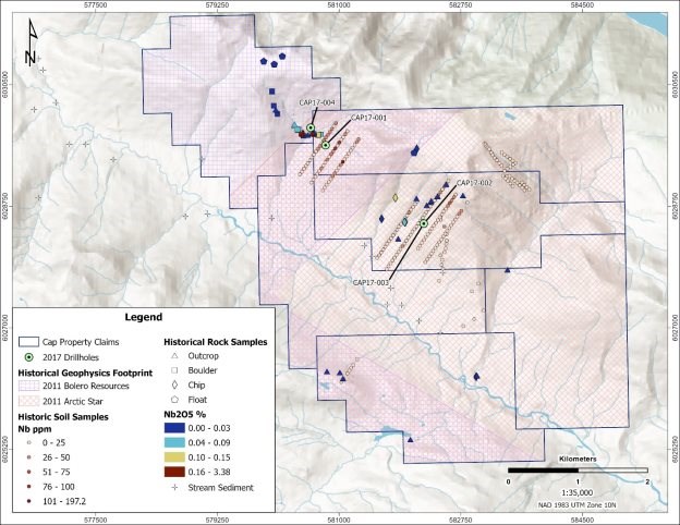
Figure 6-1 Historical Exploration Map
|
Page | 19 |
| NI 43-101 Technical Report | Apex Critical Metals Corp. |
7 Geological Setting & Mineralization
7.1 Regional Geology
CAP Property is located in the Foreland Belt, near the eastern edge of the Omineca Belt, within the Canadian Cordillera, (Wheeler, et al., 1991). The Foreland Belt was the last of orogenic belts to form in British Columbia; this occurred between the late Proterozoic and Paleozoic. The Foreland Belt consists of a geotectonic assemblage of imbricated and miogeoclinal rocks that form the eastern-most ranges of the Cordillera (Gabrielse, Monger, Wheeler, & Yorath, 1991).
Topography and structural geology of the area is dominated by the Rocky Mountain Trench ("RMT"), a northwest-trending structural feature that can be traced from the northern edge of British Columbia to the southeastern corner. Taylor and Stott (1979) indicate there are two fault trends in the Monkman Pass region. One trend follows the McLeod Lake Fault Zone at approximately 160°, with movement interpreted as mid-Tertiary. The other set includes the older northern Rocky Mountain Trench fault system, which trends approximately 140°.
Most of the area around Prince George is covered in glacial deposits of various types, locally exceeding 100 m in thickness and results in sparse outcrop exposure. Details on the bedrock geology in NTS map sheet 93I (Monkman Pass) northeast of Prince George is limited to work by G.C. Taylor and D.F. Stott from the 1970's; the most recent detailed geologic map of the area was completed by Taylor and Stott in (1979).
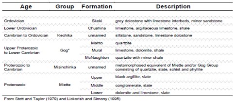
The region is dominated by upper Proterozoic and Paleozoic sedimentary and metamorphic rocks (Table 7-1) separated by southeast trending fault zones (Figure 7-1). The oldest unit rocks in the area belong to the Proterozoic Miette Group, which Taylor (1979) subdivides into three units: a lowermost recrystallized dolomite and limestone, a middle, substantially thick package of quartzose conglomerates, and an uppermost, relatively thin unit of black argillites. The Miette Group is overlain by the upper Proterozoic to lower Cambrian Gog Group. The Gog Group is subdivided into three formations: the basal McNaughton Formation, a quartzite with interbedded shale unit; the middle Mural Formation, a limestone, dolomite and shale unit; and the upper Mahto Formation, a quartzose sandstone unit. The metamorphosed equivalents of the Miette and Gog groups were classified as the Misinchinka Group by Stott and Taylor (1979), which generally consists of quartzite, slate, schist and phyllite metamorphosed to greenschist grade.
Table 7-1 Stratigraphic Units in the Monkman Pass Area
|
Page | 20 |
| Cap Property - BC, Canada |
The Gog Group and/or Misinchinka Group rocks are overlain by the Ordovician Skoki and Chushina formations. The Chushina Formation, also referred to as the Kechika Group, McKay Group, and Mount April Formation in other parts of British Columbia ( Thompson, 1989), is comprised of a succession of lower Ordovician limestone, slate, argillite and siltstone. The Skoki Formation consists of oncolitic dolomite and minor sandstone (Norford, et al., 1995).
Several carbonatite complexes have been identified in British Columbia. Those that have been identified often occur on either side of, and parallel to, the RMT (Pell, 1994). They are generally believed to be Devonian to Mississippian in age, based on limited age dating, and they appear to intrude Ordovician or older rocks. Carbonatite complexes generally consist of sub-circular to elliptical bodies with extensive metasomatic alteration, foliated and deformed sill-like bodies, or linear zones of small plugs, dikes and sills, such as in the Wicheeda Lake Carbonatite Complex.
|
Page | 21 |
| NI 43-101 Technical Report | Apex Critical Metals Corp. |
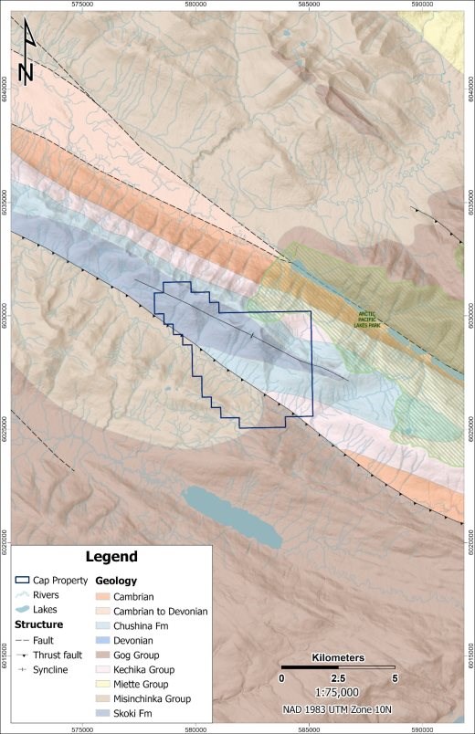
Figure 7-1 Regional Geology
|
Page | 22 |
| Cap Property - BC, Canada |
7.2 Local & Property Geology
Detailed geological understanding of the Cap Property remains at an early stage due to limited focused geological mapping and sparse bedrock exposure, with much of the Property covered by glacial deposits, colluvium, and vegetation. Where exposed, bedrock is dominated by sedimentary units interpreted to belong to the Skoki and/or Chushina formations, consisting primarily of variably dolomitic limestone with local argillaceous intervals and thin shale interbeds (Figure 7-2).
In the southern portion of the Property, massive, brecciated limestone outcrops have been observed and may represent a carbonate unit within the Gog Group; however, the stratigraphic assignment of these units remains uncertain and requires further investigation. Additional outcrops of weakly to moderately phyllitic shale and mudstone are interpreted to belong to the Misinchinka Group.
In addition to sedimentary lithologies, historical mapping identified small, discontinuous outcrops of altered syenite, along with several mineralized carbonatite boulders. Historical drilling from drillhole CAP17-004, confirmed the presence of carbonatite and associated fenite at depth.
Recent exploration programs completed by Apex have expanded upon known mineralization through surface sampling and drilling. Surface rock sampling completed in 2024 identified carbonatite, fenite, and related altered lithologies at surface, supporting the presence of a mineralized intrusive system extending beyond the immediate vicinity of historical drilling. In 2025, diamond drilling intersected additional carbonatite and fenite along trend of drillhole CAP17-004, confirming lateral continuity of carbonatite-hosted mineralization extends beyond the limits defined by earlier drilling.
The timing, internal geometry, and emplacement history of the carbonatite, fenite, and associated intrusive phases remain poorly constrained, although available evidence indicates that these intrusive rocks are younger than the surrounding sedimentary units and near vertical in orientation. Further geological mapping, drilling, and geochronological studies are required to better define the geometry, extent, and evolution of carbonatite on the Cap Property.
|
Page | 23 |
| NI 43-101 Technical Report | Apex Critical Metals Corp. |
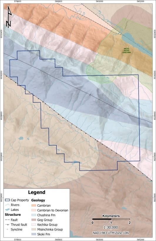
Figure 7-2 Property Geology
|
Page | 24 |
| Cap Property - BC, Canada |
7.3 Mineralization
Mineralization on the Cap Property is hosted primarily within carbonatite and carbonatite-associated intrusive rocks, including fenite-altered country rock and syenitic intrusions. Mineralization is characterized by niobium enrichment, locally accompanied by phosphate (P₂O₅) and isolated intervals of elevated rare earth elements (REEs).
Early surface exploration identified limited exposures of mineralized intrusive rocks. Historical geochemical sampling included a small number of rock samples collected from altered syenite and carbonatite float, with one surface syenitic sample returning elevated niobium values (0.27% Nb₂O₅). While these results demonstrated the presence of niobium-bearing mineralization at surface, the limited spatial coverage did not allow assessment of mineralized continuity.
Subsurface mineralization was confirmed by drilling. In 2017, drillhole CAP17-004 intersected carbonatite and fenite, confirming mineralization at depth. More recent drilling completed in 2025 intersected additional carbonatite and fenite, confirming lateral continuity of mineralization beyond the limits defined by 2017 drilling. Phosphate mineralization occurs over continuous intervals within portions of the carbonatite, where niobium and rare earth element enrichment is spatially variable and occurs in localized zones. Not all drillholes intersected significant mineralization.
Limited mineralogical information is currently available for the Property. Historical mineralogical work completed on one surface syenitic sample identified pyrochlore as the principal niobium-bearing mineral (Millonig, 2013). Visual observations made during geological logging of the 2025 drill core are consistent with this interpretation; however, these observations are qualitative only and have not yet been confirmed by dedicated mineralogical studies. Additional petrographic and mineralogical work is required.
|
Page | 25 |
| NI 43-101 Technical Report | Apex Critical Metals Corp. |
8 Deposit Type
Mineralization targeted on the Cap Property is hosted by magmatic carbonatite and carbonatite-associated intrusive rocks, similar in style to other alkaline intrusive carbonatite systems in British Columbia, including the Wicheeda Lake Carbonatite Complex. Carbonatites are igneous rocks characterized by abundant primary carbonate minerals, most commonly calcite and/or dolomite, and are genetically associated with mantle-derived alkaline magmatism.
The International Union of Geological Sciences (IUGS) defines carbonatites as igneous rocks composed of greater than 50 modal percent primary carbonate minerals and less than 20 weight percent silica (SiO₂). Alternative classification schemes expand this definition to include rocks containing greater than 30 modal percent primary carbonate, recognizing the genetic continuity between carbonate-rich intrusive phases within a single magmatic system (Mitchell, 2005). Variations in modal mineralogy commonly occur over short distances as a result of magmatic differentiation primarily through fractional crystallization and liquid immiscibility, and the resulting carbonatites are typically classified based on the dominant carbonate mineral present.
Carbonatite-related mineral deposits are commonly classified as primary (magmatic) or metasomatic (carbothermal) in origin, with supergene equivalents developing where prolonged chemical weathering has occurred (Mariano, 1989); (Richardson & Birkett, 1996); (Mitchell, 2005). At the Cap Property, exploration is focused on primary magmatic carbonatite mineralization, with no evidence to date for significant supergene enrichment.
Carbonatites are known to host economic or anomalous concentrations of incompatible elements, including niobium and rare earth elements (REEs, including yttrium). Niobium mineralization in magmatic carbonatite systems is most commonly hosted by the mineral pyrochlore, which typically forms during late-stage magmatic crystallization (Mariano, 1989); (Mitchell, 2005). Carbonatite intrusions commonly exert a strong metasomatic influence on their host rocks, producing alteration assemblages such as fenite, characterized by alkali metasomatism and desilicification of country rocks (Richardson & Birkett, 1996).
Within British Columbia, carbonatites typically occur as part of zoned alkaline intrusive complexes, spatially associated with undersaturated alkaline rocks such as syenite and related lithologies (Woolley & Kjarsgaard, 2008). These complexes may be emplaced as plugs, dykes, sills, or composite intrusive bodies, commonly along deep-seated structural corridors in continental settings.
The presence of carbonatite, fenite, and altered syenitic intrusive rocks on the Cap Property, confirmed by drilling and surface sampling supports interpretation of a magmatic carbonatite system with potential for niobium and rare earth element mineralization, consistent with established carbonatite deposit models.
|
Page | 26 |
| Cap Property - BC, Canada |
9 Exploration
Field exploration completed by Apex (formerly Eagle Bay Resources Corp.) on the Cap Property has focused on evaluating the potential for carbonatite-hosted niobium and rare earth element mineralization. Exploration activities completed between 2023 and 2025 included reconnaissance prospecting, geological mapping, surface geochemical sampling, drone LiDAR and photogrammetry, and airborne geophysical surveys. These programs were designed to refine geological understanding of the Property, identify surface expressions of mineralization, and support drill targeting. Diamond drilling completed in 2025 and 2026 is described separately in Section 10 of this report.
9.1 2023 Rock Sampling
In June 2023, Apex completed a reconnaissance-scale geological mapping and rock sampling program on the Cap Property. Fieldwork was completed between June 21 and June 26, 2023, and consisted of helicopter-supported geological mapping and prospecting. Approximately 7.5 km of mapping traverses were completed across the current Cap Property. Mapping focused on areas of limited bedrock exposure and targeted lithologies considered prospective for carbonatite-related mineralization.
A total of three (3) rock samples were collected from outcrop and float and submitted for geochemical analysis (Figure 9-1). Sampling was supported by the use of an RS-125 handheld gamma-ray spectrometer to identify radiometric responses commonly associated with carbonatite and alkaline intrusive systems. Lithologies observed during the program included fenite, limestone, and mudstone. No new significant mineralization was identified during the 2023 program.
Sampling methods are described in detail in Section 11, and the author recognizes that grab samples represent point locations only and are not necessarily indicative of mineralization or representative of broader mineralized zones.
9.2 2024 Rock, Soil and Stream Concentrate Sampling
In July 2024, Apex completed a helicopter-supported geological and geochemical exploration program on the Cap Property. The program was designed to expand upon earlier reconnaissance work, evaluate areas of limited bedrock exposure, and refine exploration targets associated with carbonatite-hosted mineralization.
The 2024 program included geological mapping and prospecting, rock sampling, soil sampling, and stream concentrate sampling. A total of 32 rock samples, 373 soil samples, and 26 stream concentrate samples were collected. Soil sampling was conducted over multiple grids designed to test areas interpreted to be prospective based on historical sampling and geophysical data. Stream concentrate sampling was completed to evaluate downstream geochemical signatures in areas with limited outcrop exposure. Rock samples were collected from outcrop and float where available.
Field activities were supported by handheld scintillometers to identify radiometric responses commonly associated with carbonatite and alkaline intrusive systems. Geological mapping documented sedimentary host rocks, altered intrusive lithologies, carbonatite occurrences, and structural features where exposed.
Geochemical results from the 2024 program returned anomalous to elevated niobium, phosphate, and rare earth element values in multiple sample types. Rock sampling identified carbonatite and altered intrusive lithologies with elevated niobium values. A total of five (5) outcrop samples returned values between 0.16 and 3.33% Nb2O5 and two (2) boulder samples assayed 1.44 and 1.79% Nb2O5 (Table 9-1). The mineralization identified in 2024 appears along trend with historically identified occurrences from rock sampling and drilling and established priority targets for follow up drill testing.
|
Page | 27 |
| NI 43-101 Technical Report | Apex Critical Metals Corp. |
Soil sampling completed during the 2024 exploration program outlined a well-defined niobium anomaly extending approximately 1.8 km northwest of the known carbonatite mineralization. The anomalous trend is coincident with a historically identified geophysical anomaly. The soil anomaly occurs in an area of limited bedrock exposure and extends beyond the vicinity of previously identified surface mineralization. In addition to elevated niobium values, soil sampling returned locally elevated rare earth element concentrations, including one sample (Sample ID: 80304) reporting 1.21% REO and three additional samples (Sample IDs: 80500, 80400, 80316) reporting between 0.33% and 0.34% REO (for more information regarding the individual REO components and assumptions underlying the REO values, please see Section 24 of this Report).
Stream concentrate sampling further supported the soil geochemical results. Four stream concentrate samples returned anomalous niobium values exceeding 275 ppm Nb, with a maximum value of 360 ppm Nb. These anomalous samples are spatially associated with the known carbonatite outcrop and the northwest-trending niobium soil anomaly. The 2024 soil and stream concentrate sampling programs demonstrated that surficial geochemical methods are effective for identifying and tracing carbonatite-related mineralization in areas with limited outcrop exposure on the Cap Property.
Selected representative surface rock sample results from the 2024 geochemical program are summarized in Table 9-1 and Figure 9-2. Soil sample and stream concentrate sample results are presented in Figure 9-1 to Figure 9-5. These results confirmed the presence of niobium mineralization at surface and directly informed the design and targeting of the 2025 diamond drilling program. For more information regarding the individual REO components and assumptions underlying the REO values presented in such tables and figures, please see Section 24 of this Report.
Sampling methods are described in detail in Section 11, and the Author recognizes that grab samples represent point locations only and are not necessarily indicative of mineralization or representative of broader mineralized zones.
Table 9-1 2024 Rock Sampling - Select Assay Results
|
Sample ID |
Type |
Nb₂O₅ % |
P₂O₅ % |
REO % (1) |
|
80138 |
Outcrop |
3.33 |
0.92 |
0.16 |
|
80130 |
Boulder |
1.79 |
0.68 |
0.13 |
|
80146 |
Float |
1.45 |
0.35 |
0.09 |
|
80102 |
Outcrop |
0.5 |
9.34 |
0.15 |
|
80136 |
Outcrop |
0.38 |
3.2 |
0.16 |
|
80143 |
Outcrop |
0.2 |
1.39 |
0.06 |
|
80139 |
Outcrop |
0.16 |
0.59 |
0.08 |
|
Page | 28 |
| Cap Property - BC, Canada |
1. Rare Earth Oxide (REO) is the summation of Ce₂O₃, La₂O₃, Pr₂O₃, Nd₂O₃, Sm₂O₃, Eu₂O₃, Gd₂O₃, Tb₂O₃, Dy₂O₃, Ho₂O₃, Er₂O₃, Tm₂O₃, Yb₂O₃, Lu₂O₃, and Y₂O₃. For more information regarding the individual REO components and assumptions underlying the REO values, please see Section 24 of this Report.
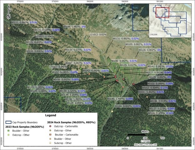
Figure 9-1 2023-2024 Surface Rock Samples - Nb₂O₅% and REO%
|
Page | 29 |
| NI 43-101 Technical Report | Apex Critical Metals Corp. |
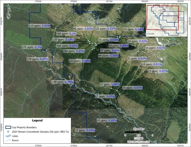
Figure 9-2 2024 Stream Concentrate Samples - Nb₂O₅% and REO%
|
Page | 30 |
| Cap Property - BC, Canada |
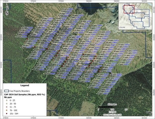
Figure 9-3 Grid 1 - 2024 Soil Samples - Nb (ppm) and REO (%)
|
Page | 31 |
| NI 43-101 Technical Report | Apex Critical Metals Corp. |
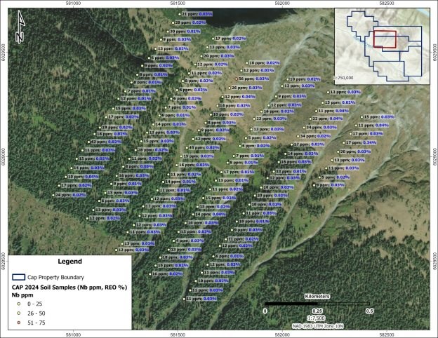
Figure 9-4 Grid 2 - 2024 Soil Samples - Nb (ppm) and REO (%)
|
Page | 32 |
| Cap Property - BC, Canada |
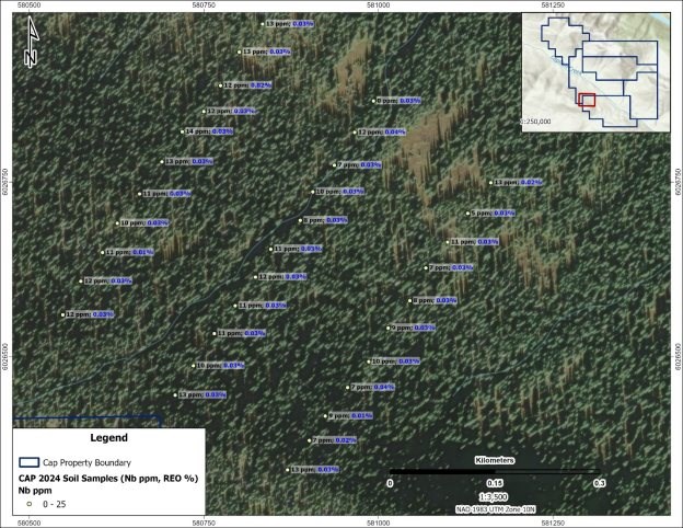
Figure 9-5 Grid 3 - 2024 Soil Samples - Nb (ppm) and REO (%)
9.3 2024 Drone LiDAR and Photogrammetry
In 2024, Apex completed a drone-based LiDAR and photogrammetry survey over priority areas of the Cap Property. The survey was designed to generate high-resolution topographic and orthophoto datasets to support geological interpretation, environmental planning, and drill program design.
The survey produced detailed digital elevation models, hillshade imagery, and orthophotography, which were used to improve understanding of surface morphology, drainage patterns, access constraints, and surface expressions of geological features in areas of limited bedrock exposure. The LiDAR and photogrammetry data were integrated with geological mapping and surface geochemical datasets to support exploration planning and drill targeting.
9.4 Airborne Magnetic and Radiometric Survey
In September 2025, Apex completed a high-resolution helicopter-borne airborne magnetic and radiometric survey over the Cap Property. The survey was designed to refine interpretation of subsurface geology and improve delineation of structural features potentially associated with carbonatite mineralization.
|
Page | 33 |
| NI 43-101 Technical Report | Apex Critical Metals Corp. |
The survey was completed by Precision GeoSurveys Inc. and consisted of approximately 781 line-kilometres of data collected at 40-m line spacing oriented NE-SW, providing significantly improved resolution relative to historical regional datasets. Magnetic and radiometric data were acquired concurrently and processed using standard industry procedures.
The airborne survey delineated a large, coherent magnetic anomaly located on the central-eastern portion of the Property (Figure 9-6). This feature is interpreted to reflect a buried intrusive body based on its geometry and magnetic intensity; however, the anomaly has not yet been tested by drilling or other subsurface methods, and its source remains unconfirmed. Radiometric data provided additional information on surface and near-surface lithological variation (Figure 9-7). Interpretation of the geophysical data remains preliminary, and additional geological work and drilling will be required to evaluate the nature and significance of the identified anomaly.
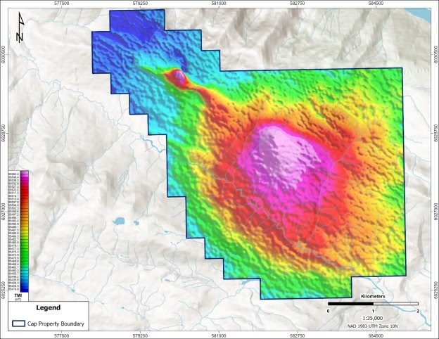
Figure 9-6 2025 Airborne Geophysical Survey - Total Magnetic Intensity
|
Page | 34 |
| Cap Property - BC, Canada |
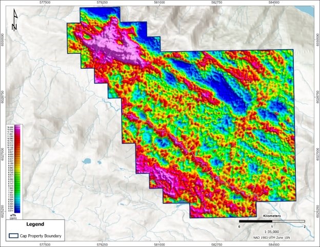
Figure 9-7 2025 Airborne Geophysical Survey - Thorium
|
Page | 35 |
| NI 43-101 Technical Report | Apex Critical Metals Corp. |
10 Drilling
Apex completed a helicopter-supported diamond drilling program on the Cap Property from July through September 2025. The 2025 program was designed to test carbonatite-hosted niobium, phosphate, and rare earth element mineralization previously identified from historical drilling completed in 2017 and surface geochemical results from the 2024 exploration program. A follow up drill program was completed by Apex from June to July 2026.
The 2025 drill program consisted of nine (9) NQ-size diamond drillholes totaling 2,323 m. Drillhole locations were positioned to test priority geological and geophysical targets, including step-out drilling along trend from historical drillhole CAP17-004, as well as additional targets identified through surface geochemistry and geophysical interpretation.
The 2026 drill program consisted of three (3) NQ-size diamond drillholes totalling 1,072 m. Two drillholes followed up on positive results from the 2025 drill program, attempting to further delineate niobium mineralization identified in drillhole CAP25-006. One drillhole targeted the prominent magnetic anomaly southeast of the 2025 drill area, evaluating the magnetic feature at depth. Assay results from the 2026 program are pending as of the effective date of this Report.
Drill casings were left in all drillholes to allow for future re-entry, except for CAP25-013, with the top of each hole casing sealed using a steel cap. Hole ID's punched directly into the casing cap using a punch kit for future verification. All collar coordinates were measured using a Trimble Catalyst DA2 GNSS Receiver, which was connected to a compatible smartphone. Downhole deviation survey data was collected upon completion of each drillhole using an OMNIx42 (2025) or Axis Champ Navigator (2026), with continuous survey shots on inclined holes at 3 m intervals or multi-shots every 20 m on vertical or near-vertical holes.
All drilling in both 2025 and 2026 was completed using NQ-size diamond drill core. Drill core was placed in labelled core boxes at the drill site and transported by helicopter to a secure logging facility. Core recovery was generally good with the exception of isolated fault intersections that resulted in reduction in recovery. No issues were identified that would be expected to materially affect the quality or reliability of the drilling results.
Core sampling protocols followed industry standard practices. Upon receipt at the core shack, all drill core was pieced together, oriented to maximum foliation, metre-marked, geotechnically logged (including structures), alteration logged, geologically logged, radioactivity logged and sample logged on an individual sample basis. Geological data was recorded using MX Deposit software. Wet and dry core box photographs were taken of all drill cores received, regardless of perceived mineralization. Specific gravity (SG) measurements of drill core were marked for processing by the laboratory at systematic intervals, approximately one specific gravity measurement every ~12 m. Detailed sampling, analytical procedures, and quality assurance/quality control protocols are described in Section 10.2 of this Report.
Diamond drilling in 2025 was carried out by Quesnel Brothers Diamond Drilling Ltd. and in 2026 by Proterra. Both programs were managed by Dahrouge Geological Consulting Ltd. on behalf of Apex. Drillhole collar locations, orientations, and lengths are summarized in Table 10-1, and displayed in Figure 10-1.
|
Page | 36 |
| Cap Property - BC, Canada |
Table 10-1 Drillhole Locations and Attributes
| Year | Hole ID | Depth (m) |
Azimuth(2) (°) |
Dip (2) (°) |
Easting (1) |
Northing (1) |
Elevation (masl) |
| 2025 | CAP25-005 | 351.0 | 210 | -60 | 580690.4 | 6029956.4 | 1284.7 |
| CAP25-006 | 240.0 | 220 | -65 | 580428.7 | 6029895.4 | 1258.0 | |
| CAP25-007 | 417.1 | 220 | -89 | 580430.3 | 6029896.5 | 1260.2 | |
| CAP25-008 | 89.0 | 40 | -45 | 580431.9 | 6029901.4 | 1261.6 | |
| CAP25-009 | 374.0 | 180 | -50 | 579919.0 | 6030205.7 | 1522.2 | |
| CAP25-010 | 296.0 | 225 | -50 | 579917.1 | 6030207.3 | 1523.1 | |
| CAP25-011 | 87.1 | 40 | -45 | 579938.0 | 6029956.9 | 1435.0 | |
| CAP25-012 | 374.6 | 45 | -50 | 579938.0 | 6029956.8 | 1434.9 | |
| CAP25-013 | 95.0 | 120 | -50 | 579939.2 | 6029954.6 | 1433.3 | |
| 2026 | CAP26-014 | 110.0 | 260 | -55 | 580425.9 | 6029898.0 | 1260.2 |
| CAP26-015 | 134.0 | 175 | -60 | 580430.9 | 6029895.0 | 1259.7 | |
| CAP26-016 | 828.4 | 330 | -60 | 582722.9 | 6028062.1 | 1304.8 |
(1) Coordinates are presented in NAD83 UTM Z10
(2) Azimuth and Dip presented are planned and may vary downhole
|
Page | 37 |
| NI 43-101 Technical Report | Apex Critical Metals Corp. |
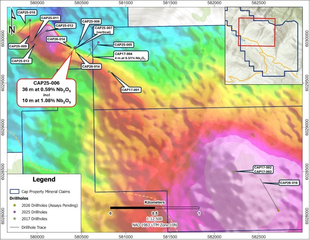
Figure 10-1 2025 and 2026 Drillhole Location Map
10.1 2025 Drill Results
The 2025 diamond drilling program tested multiple targets across the Cap Property, including step-out drilling along trend from historical drillhole CAP17-004 and additional targets defined by surface geochemical anomalies and historical geophysical interpretation. Drillholes were positioned to evaluate the geometry, thickness, and distribution of carbonatite-hosted mineralization.
The most significant niobium-bearing intersection was returned from CAP25-006, collared approximately 170 m west-southwest of CAP17-004 and drilled toward the southwest (Az 220°, Dip −65°). CAP25-006 intersected a broad interval of 124.5 m (12.0-136.5 m) averaging 0.27% Nb₂O₅, with associated phosphate and rare earth element enrichment. This interval includes higher-grade zones, notably a 10.0 m interval (33.5-43.5 m) averaging 1.08% Nb₂O₅, as well as a broader 36.0 m interval (33.5-69.5 m) averaging 0.59% Nb₂O₅ (Table 10-2).
Drillhole CAP25-007, collared at the same drill pad location as CAP25-006 but drilled at a steeper inclination (Az 220°, Dip −89°), intersected multiple mineralized intervals, including a broad 45.0 m interval (282.0-327.0 m) averaging 6.2% P₂O₅, with associated niobium and rare earth element enrichment. Several shorter sub-intervals returned elevated phosphate values exceeding 10% P₂O₅, including 3.8 m averaging 16.2% P₂O₅ (Table 10-2).
|
Page | 38 |
| Cap Property - BC, Canada |
Drillhole CAP25-005, collared approximately 125 m northeast of CAP17-004, intersected several discrete mineralized intervals at depth characterized by moderate niobium enrichment and elevated phosphate and rare earth element values. Notable intercepts include 8.4 m averaging 0.11% Nb₂O₅ and 8.8% P₂O₅, 10.1 m averaging 0.09% Nb₂O₅ and 7.5% P₂O₅, and one narrower interval returning an REO value of 1.08% (Table 10-2). While mineralization in CAP25-005 is less continuous and more variable than that intersected in CAP25-006, these results indicate that carbonatite-related geochemical enrichment extends at depth below the 2017 drillhole, CAP17-004.
In the northwestern portion of the Property, drilling from a common collar location tested geophysical and geochemical targets at higher elevation. CAP25-012 intersected a broad interval of 97.2 m (246.6-343.7 m) averaging 4.5% P₂O₅, including 58.2 m averaging 5.6% P₂O₅. CAP25-013, drilled from the same setup, intersected a narrower mineralized interval of 3.3 m averaging 8.0% P₂O₅ and 0.14% Nb₂O₅ (Table 10-2). CAP25-011 had to be terminated early due to poor drilling conditions and did not return significant mineralization.
Drillholes CAP25-009 and CAP25-010, collared in the northwestern portion of the Property, intersected multiple narrow intervals of niobium and phosphate enrichment, as well as localized rare earth element-enriched zones (Table 10-2). While these holes returned shorter mineralized intercepts relative to CAP25-006 and CAP25-012, they confirm that carbonatite-related mineralization occurs across multiple areas of the Property.
Drillhole CAP25-008, drilled as a scissor hole from the central collar location toward the northeast, did not return significant mineralization. The drillhole provided an important constraint, indicating that mineralization intersected in CAP25-006 and CAP25-007 is not uniformly distributed around the collar location and is likely controlled by the geometry of carbonatite phases and associated alteration, which is interpreted to be steeply dipping in this location.
The 2025 drill program and subsequent 3D modelling indicate that drilling intersected a carbonatite-fenite intrusive system, with fenite forming a broad, laterally extensive altered envelope and carbonatite occurring as variably thick, discontinuous bodies within this package. Carbonatite was intersected in eight of nine drillholes completed in 2025 (all except CAP25-008), demonstrating that the intrusive system extends over a substantial strike and at depth.
Several drillholes intersected intrusive lithologies in addition to carbonatite and fenite. In particular, drillholes CAP25-009 and CAP25-012 intersected >50 m intervals of syenite. The presence of syenite in multiple drillholes confirms that intrusive rocks other than carbonatite are present within the drilled area, although their continuity, timing, and role in mineralization require further evaluation.
Niobium mineralization occurs within both carbonatite and strongly altered (fenitic) intrusive rocks, with localized higher-grade niobium intervals, particularly in CAP25-006. In contrast, phosphate mineralization is more consistent and occurs over broader and more continuous intervals, particularly in drillholes such as CAP25-007 and CAP25-012. Rare earth element enrichment is present but spatially discontinuous, occurring primarily as narrow, localized intervals within carbonatite, with several drillholes returning REO values exceeding 1-2% over short core lengths.
|
Page | 39 |
| NI 43-101 Technical Report | Apex Critical Metals Corp. |
Overall, the 2025 drilling confirms the presence of a large, multi-phase carbonatite system on the Cap Property characterized by a fenite alteration halo, variably developed carbonatite bodies, laterally extensive phosphate mineralization, and localized zones of elevated niobium and rare earth element enrichment. The observed distribution of lithologies and mineralization indicates that there is significant variability of mineralization within the carbonatite and further drilling will be required to better define the geometry, continuity, and controls on niobium- and REE-enriched mineralization within the carbonatite system.
Table 10-2 Summary of Select Drill Results - 2025 Drill Program
| Hole ID | From (m) |
To (m) | Length (m)(1) |
Nb2O5 (%) |
P2O5 (%) |
REO (%)(2) |
| CAP25-005 | 269.4 | 277.8 | 8.4 | 0.11 | 8.8 | 0.18 |
| CAP25-005 | 292.0 | 293.8 | 1.8 | 0.22 | 11.4 | 0.17 |
| CAP25-005 | 298.3 | 308.4 | 10.1 | 0.09 | 7.5 | 0.11 |
| CAP25-005 | 308.4 | 311.4 | 3.0 | 0.01 | 0.5 | 1.09 |
| CAP25-006 | 12.0 | 136.5 | 124.5 | 0.27 | 3.5 | 0.13 |
| including | 23.2 | 81.0 | 57.8 | 0.46 | 2.8 | 0.12 |
| or | 33.5 | 69.5 | 36.0 | 0.59 | 3.1 | 0.13 |
| or | 33.5 | 43.5 | 10.0 | 1.08 | 2.9 | 0.14 |
| CAP25-006 | 95.5 | 101.5 | 6.0 | 0.12 | 10.4 | 0.16 |
| CAP25-006 | 136.5 | 139.8 | 3.4 | 0.00 | 0.6 | 1.33 |
| including | 136.5 | 137.5 | 1.1 | 0.01 | 0.0 | 2.30 |
| CAP25-007 | 15.0 | 17.0 | 1.9 | 0.40 | 1.3 | 0.08 |
| CAP25-007 | 38.0 | 42.4 | 4.4 | 0.15 | 8.5 | 0.18 |
| CAP25-007 | 242.4 | 254.0 | 11.6 | 0.13 | 5.2 | 0.12 |
| CAP25-007 | 282.0 | 327.0 | 45.0 | 0.13 | 6.2 | 0.12 |
| including | 282.0 | 291.0 | 9.0 | 0.08 | 9.9 | 0.15 |
| or | 283.0 | 286.8 | 3.8 | 0.11 | 16.2 | 0.24 |
| CAP25-007 | 378.5 | 380.5 | 2.0 | 0.00 | 1.2 | 1.00 |
| CAP25-008 | No significant results returned | |||||
| CAP25-009 | 117.0 | 123.0 | 6.0 | 0.03 | 4.8 | 0.06 |
| CAP25-009 | 153.9 | 157.5 | 3.6 | 0.22 | 1.5 | 0.10 |
| CAP25-009 | 369.8 | 371.7 | 1.9 | 0.02 | 0.7 | 0.58 |
| CAP25-010 | 118.1 | 128.5 | 10.4 | 0.02 | 5.6 | 0.07 |
| including | 118.1 | 119.7 | 1.6 | 0.01 | 14.5 | 0.15 |
| CAP25-010 | 188.2 | 189.2 | 1.0 | 0.02 | 0.2 | 2.07 |
| CAP25-010 | 200.5 | 201.5 | 1.0 | 0.39 | 2.1 | 0.10 |
| CAP25-011 | No significant results returned | |||||
| CAP25-012 | 246.6 | 343.7 | 97.2 | 0.02 | 4.5 | 0.12 |
| CAP25-012 | 285.5 | 343.7 | 58.2 | 0.01 | 5.6 | 0.15 |
| including | 317.1 | 343.7 | 26.6 | 0.01 | 7.9 | 0.13 |
| CAP25-012 | 305.5 | 306.1 | 0.6 | 0.01 | 0.0 | 1.73 |
| CAP25-012 | 316.3 | 317.1 | 0.8 | 0.01 | 0.2 | 2.15 |
| CAP25-013 | 91.7 | 95.0 | 3.3 | 0.14 | 8.0 | 0.12 |
| including | 93.3 | 95.0 | 1.7 | 0.23 | 8.3 | 0.10 |
|
Page | 40 |
| Cap Property - BC, Canada |
(1) All intervals are core length and do not represent true thickness
(2) Rare Earth Oxide (REO) is the summation of Ce₂O₃, La₂O₃, Pr₂O₃, Nd₂O₃, Sm₂O₃, Eu₂O₃, Gd₂O₃, Tb₂O₃, Dy₂O₃, Ho₂O₃, Er₂O₃, Tm₂O₃, Yb₂O₃, Lu₂O₃, and Y₂O₃. For more information regarding the individual REO components and assumptions underlying the REO values, please see Section 24 of this Report.
10.2 2026 Drill Results
Assay results from all three (3) 2026 drillholes are pending as of the effective date of this Report. The following descriptions are based on geological observations and visible mineralogy recorded during core logging. Handheld XRF and radioactivity measurements were collected during logging as qualitative screening tools to guide sampling. The presence of carbonatite or associated mineralogy observed visually in drill core is not indicative of economic mineralization, and formal assay results are required to evaluate the grade and continuity of any mineralization intersected.
CAP26-014 and CAP26-015 were collared from the same drill pad as CAP25-006, with both holes designed to further define the carbonatite-hosted niobium mineralization intersected in that hole. CAP26-014 was drilled toward the west-southwest (Az 260°, Dip −55°) to a total depth of 110.0 m. Carbonatite was intersected from immediately below overburden (7.3 m) to end of hole, dominated by silicocarbonatite, calcite carbonatite, and fenite/carbonatite with characteristic flow banding. Three narrow mafic dykes, each less than 1.2 m wide, were intersected between 62.6 m and 71.1 m.
CAP26-015 was drilled toward the south-southeast (Az 175°, Dip −60°) to a total depth of 134.0 m. Carbonatite and fenite were intersected from 4.8 m to end of hole, with consistent flow banding throughout. A prominent fenite interval of 17.7 m was logged between 30.3-48.0 m. Two narrow mafic dykes were intersected at 74.0 to 74.6 m and 116.5 to 120.0 m.
CAP26-016 was drilled from a collar location approximately 2.3 km southeast of the 2025 drill area (Az 330°, Dip −60°) to a total depth of 828.4 m, targeting the prominent magnetic anomaly at depth. The drillhole intersected predominantly metasedimentary lithologies throughout, consisting of interbedded limestone, shale, and phyllitic metasediment. Two lamprophyre dykes were intersected at 186.4-189.9 m and 763.1-769.7 m. A single narrow interval of probable calcite carbonatite (0.5 m) was identified at 594.6 m based on field observations. Near end of hole, short intervals between 792.4-801.1 m were interpreted in the field as syenite or fenitized calc-silicate; lithological identification of these intervals remains preliminary. The source of the magnetic anomaly was not identified in CAP26-016.
The 2026 drill program successfully intersected carbonatite-fenite lithologies in CAP26-014 and CAP26-015 and tested the magnetic anomaly in CAP26-016. The source of the anomaly was not identified in CAP26-016, and geophysical reprocessing and 3D inversion is recommended prior to any further drilling of this target. Assay results from all three (3) drillholes are pending as of the effective date of this Report, with full geological interpretation and assessment of the 2026 program to be completed upon receipt of analytical results.
|
Page | 41 |
| NI 43-101 Technical Report | Apex Critical Metals Corp. |
10.3 Structure
Drillholes CAP25-009 through CAP25-013 intersected multiple fault zones of variable thickness and character throughout the drilled intervals. These structures are commonly expressed as broad zones of broken to rubbled core, locally containing clay-rich fault gouge, core loss, and intense fracturing, and in places complete core pulverization. Fault zones range from centimetre-scale structures to multi-metre-thick zones exceeding 20 m in downhole length and locally display evidence of displacement, shearing, brecciation, and oxidation.
At this stage of exploration, correlation of individual fault zones between drillholes remains uncertain due to limited drilling density and variable structural orientations. However, the frequency, thickness, and intensity of faulting observed indicate that the Property is structurally complex. Additionally, relationship between drill orientation and the orientation of mineralization is not sufficiently constrained, and it is therefore unknown whether drill intersections represent true widths. Continued identification, modelling, and interpretation of these fault zones are considered important for understanding the potential controls on carbonatite emplacement, and the localization of associated niobium and rare earth element mineralization.
|
Page | 42 |
| Cap Property - BC, Canada |
11 Sample Preparation, Analysis & Security
11.1 Pre-Analysis Sample Preparation and Quality Control
Historical (pre-2023) exploration data was generated by previous operators using industry-standard practices of the time; however, detailed sample preparation, analytical, and quality control documentation has not been independently verified by the Qualified Person.
2023/2024 Exploration Programs
During the 2023 and 2024 surface sampling programs, all rock grab samples were collected in the field using a hammer and chisel. Soil samples were collected from the presumed B horizon using a hand auger and/or GeoTul. Stream concentrate samples were collected by filling approximately ¾ of a 12x20 cm sample bag with stream sediment. The material was first passed through a 1/8-inch sieve yielding a fine fraction that was then processed using 14" LeTrap plastic pans to concentrate the heavy fraction, resulting in approximately tens of grams per sample. The concentrate was then transferred to a pre-labeled zip-lock sample bag with a corresponding sample book tag and sample number.
Locations for all sample types were obtained using a handheld GPS or tablet with samples placed in pre-labelled sample bags. Metal tags and/or flagging tape with the sample numbers were left at each sample location. Collected samples were transported by helicopter to staff accommodations in Prince George, BC upon completion of each field day, cataloged and shipped via Manitoulin Transport to Activation Laboratories Ltd. ("Actlabs") in Kamloops, British Columbia, for analysis upon completion of the program.
The author identifies that surface grab samples and associated assays are selective by nature and represent a point location, therefore, may not be fully representative of the mineralized horizon sampled.
2025 Drill Program
Drill core was recovered by Quesnel Bros. Diamond Drilling Ltd. and placed into wooden core boxes at the drill site. Core boxes were transported by helicopter from the drill pads to the Parsnip Camp core logging facility on a regular basis, subject to weather conditions. Upon arrival at the camp, core box information was verified, core was aligned to maximum foliation and pieced together, metre-marked, and geotechnical logging was completed using industry-standard procedures.
Geological logging was carried out by Dahrouge Geological Consulting Ltd. personnel, with lithology, alteration, mineralization, structure, magnetic susceptibility, radioactivity, and textural information recorded at the appropriate scale. Sample intervals and sample identification numbers were marked directly on the drill core. All drill core was photographed wet and dry prior to sampling to provide a permanent digital record.
Sampling was guided by lithology, alteration, and indications of mineralization, with support from handheld X-ray fluorescence (XRF), magnetic susceptibility, and spectrometer measurements collected during logging. Sample lengths typically averaged between 1.0 m to 1.5 m and were adjusted as required to honour lithological contacts. All lithologies logged as carbonitite, fenite and/or syenite were sampled and submitted for analysis regardless of visible mineralization. In addition to samples collected from intervals of geological interest, host and non-mineralized rock units were locally sampled at approximately 15 m intervals where appropriate to establish background geochemical signatures.
|
Page | 43 |
| NI 43-101 Technical Report | Apex Critical Metals Corp. |
Drill core samples were cut in half using a diamond core saw. One half of the core was retained in the core box for reference, while the remaining half was collected for analysis. Where duplicate samples were required, coarse reject and pulp duplicates were generated at the laboratory and no quarter-core duplicates were collected. All remaining unsampled core was retained in core boxes and stored within a locked storage container at Parsnip Camp.
Samples were placed in labelled heavy-duty plastic sample bags, sealed, and catalogued. Individual sample bags were packaged into labelled and sealed rice sacks, which were then consolidated into large, pallet-sized supersacks. Supersacks were transported by field personnel from the Parsnip Camp to Prince George, British Columbia, and subsequently shipped via Manitoulin Transport to Activation Laboratories Ltd. ("Actlabs") in Kamloops, British Columbia, for analysis.
All analytical pulps and coarse rejects are stored at Actlabs' facilities for potential future verification or re-analysis.
The primary analytical laboratory, Activation Laboratories Ltd., is an independent, ISO/IEC 17025-accredited commercial laboratory with no affiliation to Apex. The Actlabs Kamloops facility is accredited by the Standards Council of Canada under SCC File No. 15974. The Author has reviewed the core handling, sampling, security, and analytical procedures employed during the program and considers them to be of industry standard and consistent with generally accepted best practices. The samples are considered representative of the lithologies and mineralization encountered.
2026 Drill Program
On-site core handling, logging, and sampling procedures used during the 2026 drill program were consistent with those described above for the 2025 program. Drill core was recovered by Proterra Drilling Ltd. and placed into wooden core boxes at the drill site for transport by helicopter to the Parsnip Camp core logging facility. Geological logging, photography, sampling, and core cutting procedures followed the same protocols as the 2025 program and were carried out by Dahrouge Geological Consulting Ltd. personnel. Samples were packaged and transported from Parsnip Camp to Prince George, British Columbia for shipment to Actlabs in Kamloops, British Columbia.
11.2 Laboratory Sample Preparation & Analysis
2023/2024 Exploration Programs
All rock, soil and stream concentrate samples from the 2023 and 2024 exploration programs were shipped to Activation Laboratories Ltd. preparation facility in Kamloops, British Columbia. Rock grab samples were prepped using stand sample preparation code RX1, which includes drying, crush (< 7 kg) up to 80% passing 2 mm, riffle split (250 g) and pulverize (mild steel) to 95% passing 105 µm. Analysis consisted of Code 8 by XRF Nb₂O₅, ZrO2 and Ta2O5 (0.003%), Code 8 - REE Assay and 1A2 Au Fire Assay - AA, 30g weight, 5-5,000 ppb.
The soil samples, and stream concentrate samples were prepped using code S1-230, which requires drying (60ºC) and sieving (-63 µm). Analysis consisted of packages 4B2-STD, Lithium Borate Fusion / ICP-MS Trace Element package, and 1A2 Au Fire Assay - AA, 30g weight, 5-5,000 ppb.
|
Page | 44 |
| Cap Property - BC, Canada |
2025 Drill Program
Drill core samples from the 2025 exploration program were shipped to Activation Laboratories Ltd. preparation facility in Kamloops, British Columbia, for standard sample preparation (code RX1) which includes drying, crush (< 7 kg) up to 80% passing 2 mm, riffle split (250 g) and pulverize (mild steel) to 95% passing 105 µm. The pulps were subsequently analyzed using Code 8 by XRF Nb₂O₅, ZrO2 and Ta2O5 (0.003%), Code 8 - REE Assay (lithium metaborate/tetraborate fusion with subsequent analysis by ICP and ICP/MS) and select samples analyzed for F with analytical package 4F-F.
Specific gravity (SG) measurements of drill core were marked for collection at systematic intervals, approximately one specific gravity measurement every ~12 m. The SG analysis was completed by Actlabs using code RX16. This method consists of determining the mass of a specimen in air and subsequently immersing it in water. The apparent mass of a sample upon immersion in water is determined and its specific gravity calculated.
2026 Drill Program
Drill core samples from the 2026 exploration program have been submitted to Actlabs in Kamloops, British Columbia, for analysis using the same sample preparation codes and analytical packages as the 2025 program described above. Assay results from the 2026 program are pending as of the effective date of this Report.
11.3 Quality Control & Quality Assurance
2023/2024 Exploration Programs
A Quality Assurance/Quality Control protocol was incorporated into the 2024 rock sampling program and included the insertion of two certified reference material ("CRM's) and one quartz blank representing approximately 9% of submitted samples. For the soil sampling and stream concentrate sampling, a total of five CRMs were inserted into the sample stream representing approximately 1% of the submitted samples, with the Company also relying on the internal QA/QC procedures of Actlabs.
2025 Drill Program
Apex implemented a comprehensive internal quality assurance and quality control (QA/QC) program during the 2025 drilling campaign. Control samples were inserted into the analytical sample stream on a systematic basis and included certified reference materials (CRMs), silica blanks, pulp duplicates, and coarse reject duplicates.
Of the 2,182 samples submitted, QA/QC materials consisted of 105 CRMs (~5%), 107 silica blanks (~5%), and 224 duplicate samples, comprising 112 pulp duplicates and 112 coarse reject duplicates (~10%).
11.3.1 Blanks
For the 2025 drilling campaign, blanks consisted of 0.5 kg of clean quartz pieces (1 to 4 cm in size) sourced from Jim Coleman Crystal Mines Inc., Arkansas, USA. A total of 107 silica blanks were submitted as control samples over the 2025 drilling program.
|
Page | 45 |
| NI 43-101 Technical Report | Apex Critical Metals Corp. |
Analytical results for the majority of rare earth elements and niobium indicate acceptable blank results, with mean values at or near detection limits and 100% of blanks passing quality control criteria for most analytes, including Dy, Er, Eu, Gd, Ho, Lu, Sm, Tb, Tm, Yb, and Nb₂O₅.
Low-level results were observed in a subset of analytes, particularly La, Ce, Nd, and Pr, with La showing the highest number of values exceeding the accepted upper limit of 1 ppm. Despite these exceedances, the mean blank values for all analytes remain below their respective quality control thresholds, and it is the Author's opinion that the results do not compromise the integrity of the analytical dataset.
Table 11-1 2025 Drill Program - Silica Blank Results Summary
| Analyte (ppm) |
Quantity Inserted |
Mean Grade (ppm) |
Upper Limit (ppm) / Nb2O5 (%) |
Failed (Outliers) |
% Passing Quality Control |
| Ce | 107 | 1.06 | 2 | 9 | 92% |
| Dy | 107 | 0.09 | 1 | 1 | 99% |
| Er | 107 | 0.07 | 2 | 0 | 100% |
| Eu | 107 | 0.03 | 1 | 0 | 100% |
| Gd | 107 | 0.08 | 2 | 0 | 100% |
| Ho | 107 | 0.05 | 2 | 0 | 100% |
| La | 107 | 0.77 | 1 | 18 | 83% |
| Lu | 107 | 0.02 | 0.8 | 0 | 100% |
| Nd | 107 | 0.33 | 1 | 7 | 93% |
| Pr | 107 | 0.11 | 0.5 | 4 | 96% |
| Sm | 107 | 0.09 | 2 | 0 | 100% |
| Tb | 107 | 0.05 | 40 | 0 | 100% |
| Tm | 107 | 0.03 | 1 | 0 | 100% |
| Yb | 107 | 0.07 | 2 | 0 | 100% |
| Nb2O5 (%) | 107 | 0.00 | 0.006 | 0 | 100% |
All blanks are clean quartz sourced from Jim Coleman Crystal Mines Inc., Arkansas, USA, with the exception of 2 blank insertions, sourced from OREAS 1/4" Silica Blank (500g sealed pouches).
11.3.2 Certified Reference Materials
Four certified reference materials (CRMs); CDN-RE-1201, CDN-RE-1202, CDN-RE-1203, and OREAS 465b (primarily as a Nb2O5 CRM), were used throughout the 2025 drilling program. Certified reference materials were inserted into the sample stream at a frequency of approximately one CRM for every 20 samples, or 5% of samples collected. Results are displayed in Table 11-2 through Table 11-5.
CRM performance was monitored using the following criteria: results falling within ±2 standard deviations of the certified value were considered acceptable, values between ±2 and ±3 standard deviations were flagged for review, and results exceeding ±3 standard deviations were classified as failures.
Certified reference material results from the 2025 drilling program demonstrate generally strong analytical accuracy. CRM CDN-RE-1201 returned 100% pass rates for all analytes except Nd, which recorded a single failure (97% pass rate), with mean values closely matching certified values. Results for CDN-RE-1202 include a small number of failures across multiple analytes; however, all failures are attributable to a single CRM insertion and plot close to the ±3 standard deviation control limits, indicating no systematic analytical bias. CDN-RE-1203 exhibited 100% pass rates for all analytes except Sm (96% pass rate), with two CRM insertions excluded due to a confirmed laboratory sample swap. Results for OREAS 465b show 100% of Nb₂O₅ values passing quality control criteria.
|
Page | 46 |
| Cap Property - BC, Canada |
Overall, the CRM assay data indicate acceptable analytical performance, and the limited failures observed are isolated, non-systematic, and do not materially affect the reliability of the analytical dataset.
Table 11-2 Certified reference material results with CDN-RE-1201
| Analyte | Certified Value (ppm) |
Standard Deviation |
Quantity Inserted |
Lower Limit (Certified - 3SD) |
Upper Limit (Certified +3SD) |
Mean Value (ppm) |
Failed | % Passing Quality Control |
| Ce | 1,327 | 55 | 36 | 1162 | 1492 | 1367.5 | 0 | 100% |
| Dy | 14.3 | 0.45 | 36 | 12.95 | 15.65 | 14.1 | 0 | 100% |
| Er | 6.5 | 0.25 | 36 | 5.75 | 7.25 | 6.28 | 0 | 100% |
| Eu | 8.6 | 0.4 | 36 | 7.4 | 9.8 | 8.55 | 0 | 100% |
| Gd | 22.2 | 1.2 | 36 | 18.6 | 25.8 | 20.91 | 0 | 100% |
| Ho | 2.5 | 0.1 | 36 | 2.2 | 2.8 | 2.4 | 0 | 100% |
| La | 959 | 53.5 | 36 | 798.5 | 1119.5 | 973.39 | 0 | 100% |
| Lu | No certified value | |||||||
| Nd | 311 | 9 | 36 | 284 | 338 | 315 | 1 | 97% |
| Pr | 112 | 3.5 | 36 | 101.5 | 122.5 | 111.83 | 0 | 100% |
| Sm | 35.6 | 1.55 | 36 | 30.95 | 40.25 | 35.68 | 0 | 100% |
| Tb | 2.9 | 0.15 | 36 | 2.45 | 3.35 | 2.81 | 0 | 100% |
| Tm | 0.9 | 0.05 | 36 | 0.75 | 1.05 | 0.83 | 0 | 100% |
| Y | No certified value | |||||||
| Yb | 5.1 | 0.2 | 36 | 4.5 | 5.7 | 5.06 | 0 | 100% |
| Provisional values (Lu, Y) are excluded. | ||||||||
Table 11-3 Certified reference material results with CDN-RE-1202
| Analyte | Certified Value (ppm) |
Standard Deviation |
Quantity Inserted |
Lower Limit (Certified - 3SD) |
Upper Limit (Certified +3SD) |
Mean Value (ppm) |
Failed | % Passing Quality Control |
| Ce | 3,199 | 128.5 | 34 | 2813.5 | 3584.5 | 3246.76 | 1 | 97% |
| Dy | 20.5 | 0.95 | 34 | 17.65 | 23.35 | 20.5 | 0 | 100% |
| Er | 6.8 | 0.4 | 34 | 5.6 | 8 | 6.78 | 1 | 97% |
| Eu | 18 | 0.55 | 34 | 16.35 | 19.65 | 17.87 | 0 | 100% |
| Gd | 42.1 | 2.2 | 34 | 35.5 | 48.7 | 39.9 | 0 | 100% |
| Ho | 3.1 | 0.15 | 34 | 2.65 | 3.55 | 2.98 | 0 | 100% |
| La | 2,488 | 123 | 34 | 2119 | 2857 | 2560.91 | 1 | 97% |
| Lu | 0.63 | 0.03 | 34 | 0.54 | 0.72 | 0.64 | 0 | 100% |
| Nd | 666 | 27 | 34 | 585 | 747 | 678.15 | 1 | 97% |
| Pr | 252 | 8 | 34 | 228 | 276 | 251.54 | 1 | 97% |
| Sm | 72.6 | 2.35 | 34 | 65.55 | 79.65 | 74.09 | 1 | 97% |
| Tb | 4.9 | 0.2 | 34 | 4.3 | 5.5 | 4.8 | 1 | 97% |
| Tm | 0.84 | 0.05 | 34 | 0.69 | 0.99 | 0.91 | 0 | 100% |
| Y | 76.3 | 7.5 | 34 | 53.8 | 98.8 | 69.56 | 0 | 100% |
| Yb | 4.7 | 0.2 | 34 | 4.1 | 5.3 | 4.72 | 1 | 97% |
|
Page | 47 |
| NI 43-101 Technical Report | Apex Critical Metals Corp. |
Table 11-4 Certified reference material results with CDN-RE-1203
| Analyte | Certified Value (ppm) |
Standard Deviation |
Quantity Inserted |
Lower Limit (Certified - 3SD) |
Upper Limit (Certified +3SD) |
Mean Value (ppm) |
Failed | % Passing Quality Control |
| Ce | 8110 | 624 | 26 | 6238 | 9982 | 8161.2 | 0 | 100% |
| Dy | 36.1 | 1.65 | 26 | 31.15 | 41.05 | 26.27 | 0 | 100% |
| Er | 9.5 | 0.4 | 26 | 8.3 | 10.7 | 9.33 | 0 | 100% |
| Eu | 39.5 | 1.2 | 26 | 35.9 | 43.1 | 39.26 | 0 | 100% |
| Gd | 89.6 | 4.1 | 26 | 77.3 | 101.9 | 84.21 | 0 | 100% |
| Ho | 4.8 | 0.25 | 26 | 4.05 | 5.55 | 4.7 | 0 | 100% |
| La | 6,508 | 211 | 26 | 5875 | 7141 | 6630.83 | 0 | 100% |
| Lu | 0.7 | 0.045 | 26 | 0.565 | 0.835 | 0.76 | 0 | 100% |
| Nd | 1,573 | 50.5 | 26 | 1421.5 | 1724.5 | 1596.25 | 0 | 100% |
| Pr | 619 | 16 | 26 | 571 | 667 | 624.63 | 0 | 100% |
| Sm | 160 | 4.5 | 26 | 146.5 | 173.5 | 165.04 | 1 | 96% |
| Tb | 9.7 | 0.5 | 26 | 8.2 | 11.2 | 9.4 | 0 | 100% |
| Tm | No certified value | |||||||
| Y | 112 | 12 | 26 | 76 | 148 | 101.64 | 0 | 100% |
| Yb | 5.6 | 0.25 | 26 | 4.85 | 6.35 | 5.68 | 0 | 100% |
Table 11-5 Certified reference material results with OREAS 465b
| Analyte | Certified Value (%) |
Standard Deviation |
Quantity Inserted |
Lower Limit (Certified - 3SD) |
Upper Limit (Certified +3SD) |
Mean Value (%) |
Failed | % Passing Quality Control |
| Nb2O5 | 0.599 | 0.022 | 9 | 0.5 | 0.7 | 0.6 | 0 | 100% |
|
Page | 48 |
| Cap Property - BC, Canada |
11.3.3 Pulp and Coarse Reject Duplicates
A total of 112 pulp duplicates and 112 coarse reject duplicate samples were analyzed as part of the 2025 drilling program. Duplicate results for were evaluated using total rare earth elements (TREE+Y), which demonstrate good alignment and excellent coefficient of determination between original samples and their corresponding pulp and coarse reject duplicates (Figure 11-1 and Figure 11-2).
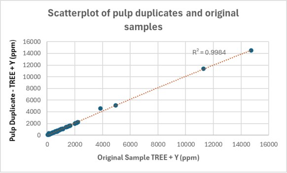
Figure 11-1 Pulp duplicate and original samples - TREE + Y (ppm)
|
Page | 49 |
| NI 43-101 Technical Report | Apex Critical Metals Corp. |
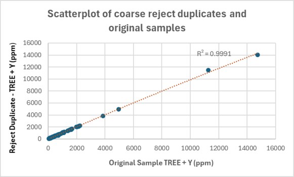
Figure 11-2 Coarse Reject duplicate and original samples - TREE + Y (ppm)
2026 Drill Program
Quartz blanks, certified reference materials (CDN-RE-1201, CDN-RE-1202, CDN-RE-1203, and OREAS 465b), and pulp and coarse reject duplicates were each inserted at a rate of approximately 5% of total samples submitted. A full assessment of QA/QC performance will be completed upon receipt of assay results.
|
Page | 50 |
| Cap Property - BC, Canada |
12 Data Verification
The Qualified Person responsible for this Technical Report is Jeremy Hanson, P.Geo. The Author has verified the data disclosed in this Report through a combination of site inspection, review of historical and recent exploration data, and independent assessment of sampling, analytical, and quality assurance/quality control ("QA/QC") procedures.
The Author visited the Cap Property on July 18, 2026. During this visit, the Author reviewed drill core from hole CAP-25-006 along with representative lithologies, alteration, and mineralization preserved in the project core library. The core logging, cutting, sampling, and storage facilities were inspected, and the sampling procedures were reviewed and found to be appropriate for the stage of exploration. The project's MX Deposit database was also reviewed, including drill hole information, collar coordinates, downhole deviation surveys, lithological, alteration, structural, magnetic susceptibility, radioactivity, and geotechnical logging, as well as assay sample records. The Author travelled to the project by helicopter and inspected the collars of drill holes CAP-25-006, CAP-25-007, and CAP-25-008. The site visit confirmed that the exploration activities, data management practices, and sample handling procedures were consistent with industry standards and appropriate to support the work described in this Report.
Additional data verification for recent work was completed through detailed desktop review and validation of exploration datasets, including geological logging procedures, drill core photographs, collar and survey information, geochemical and geophysical results, analytical certificates, and QA/QC data. Attention was given to sample preparation protocols, laboratory analytical methods, certified reference material performance, blank results, and duplicate analyses, described in Section 11 of this Report.
In addition to the site visit, data verification consisted of the Author independently downloading, confirming, and reviewing historical and publicly available technical data relevant to the Property, as well as reviewing all available data provided by the Company for exploration work completed in 2023-2025. The reports and datasets relied upon are referenced in Section 27: References.
Based on the procedures described above, it is the Author's opinion that the exploration data generated by Apex, together with the historical data relied upon, meet the required standard for a NI 43-101 Technical Report and are of sufficient quality and reliability to support the interpretations, conclusions, and recommendations presented herein.
|
Page | 51 |
| NI 43-101 Technical Report | Apex Critical Metals Corp. |
13 Mineral Processing & Metallurgical Testing
No mineral processing or metallurgical testing has been completed on the Property by the Company or its affiliates.
|
Page | 52 |
| Cap Property - BC, Canada |
14 Mineral Resource Estimate
No mineral resource estimation has been completed on the Property.
|
Page | 53 |
| NI 43-101 Technical Report | Apex Critical Metals Corp. |
15 to 22 Not Applicable
The Cap Property is an early-stage exploration project. Sections 15 to 22, as defined by NI 43-101, are not relevant to this Report and have been omitted.
|
Page | 54 |
| Cap Property - BC, Canada |
23 Adjacent Properties
Several mineral properties operated by junior exploration companies occur in the vicinity of the Cap Property and are considered relevant for providing regional geological and exploration context (Figure 23-1). Apex has no interest in these properties, and the information summarized below has been derived from publicly available disclosure. The Author has not independently verified this information, and the information is not necessarily indicative of the mineralization on the Property that is the subject of this Technical Report.
Defense Metals Corp. - Wicheeda Rare Earth Project
The Wicheeda Project, located approximately 11 km northwest of the Cap Property, is a carbonatite-syenite intrusive complex hosting significant rare earth element mineralization. The property is 100% owned by Defense Metals Corp. and is considered an advanced stage project. An updated NI 43-101 Mineral Resource Estimate for the Wicheeda deposit (effective August 28, 2023) reported a Total Measured + Indicated (M+I) resource of 34.2 Mt averaging 2.02 % REO (Raffle & Dufresne, 2023).
In addition to the Resource Estimate, Defense Metals' 2025 Pre-Feasibility Study (PFS) reported a mineral reserve base consisting of 25.5 Mt Proven & Probable ore averaging 2.43 % REO supported by an open-pit mining scenario, with further inferred material outside the reserve shell. The Wicheeda Project has undergone extensive geological, metallurgical, and economic studies aimed at advancing the deposit toward potential development, including a NI 43-101 PFS filed in 2025.
Information regarding the Wicheeda Project is provided for regional context only. The Qualified Person has not independently verified the data or estimates reported by Defense Metals Corp., and mineralization on adjacent or nearby properties is not necessarily indicative of mineralization on the Cap Property.
NeoTech Metals Corp. - TREO Project
NeoTech Metals Corp. holds the 100 %-owned TREO Project, located approximately 10 km northwest of the Cap Property. The TREO Project is a rare earth element-focused carbonatite/alkaline system for which NeoTech completed an inaugural diamond drilling program in 2025, consisting of four drillholes totaling approximately 991 m, and confirmed multiple mineralized intervals with visible rare earth mineralization in core (Neotech Metals, 2025). Public disclosure (Neotech Metals, 2025) indicates that the program was designed to test for rare earth element mineralization within alkaline intrusive carbonatites.
As of the date of this Report, no mineral resource estimate has been published for the TREO Project. The Author has not independently verified NeoTech's drill results or other technical data; information is presented here for regional context only and should not be construed as indicative of mineralization on the Cap Property.
|
Page | 55 |
| NI 43-101 Technical Report | Apex Critical Metals Corp. |
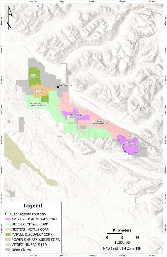
Figure 23-1 Adjacent Property Map
|
Page | 56 |
| Cap Property - BC, Canada |
24 Other Relevant Data & Information
Except as otherwise noted below, the Author is not aware of any other relevant data or information needed to make this Technical Report understandable and not misleading.
REO, or rare earth oxide, is a reporting convention used within the rare earth industry, defined by the Company as the sum of the following individual rare earth oxides: Ce₂O₃, La₂O₃, Pr₂O₃, Nd₂O₃, Sm₂O₃, Eu₂O₃, Gd₂O₃, Tb₂O₃, Dy₂O₃, Ho₂O₃, Er₂O₃, Tm₂O₃, Yb₂O₃, Lu₂O₃, and Y₂O₃.
REO is not a directly measured assay result. Individual rare earth elements are reported by the analytical laboratory in parts per million (ppm) on an elemental basis. Each element is converted to its corresponding oxide using a fixed gravimetric conversion factor derived from molecular weight ratios, as set out in Table 24-1 below. The oxide value for each element is calculated as:
Oxide (ppm) = Element (ppm) × Conversion Factor
The REO value reported for a given sample or interval is the arithmetic sum of the fifteen individual oxide values (ppm), converted to a percentage:
REO (%) = Σ (individual oxides, ppm) ÷ 10,000
The individual element-to-oxide conversion factors used by the Company are set out below. The conversion factors are standard gravimetric factors based on the ratio of the molecular weight of each rare earth oxide to the atomic weight of its corresponding element, and are consistent with factors commonly applied across the rare earth exploration industry. REO values presented by the Company reflect the sum of assayed individual oxide grades and do not imply any metallurgical recovery, as recoveries have not yet been established for the Property.
Table 24-1 Element-to-Oxide Conversion Factors
|
Element |
Oxide |
Conversion Factor |
Assay Unit |
|
Ce |
Ce2O3 |
1.1713 |
ppm |
|
Dy |
Dy2O3 |
1.1477 |
ppm |
|
Er |
Er2O3 |
1.1435 |
ppm |
|
Eu |
Eu2O3 |
1.1579 |
ppm |
|
Gd |
Gd2O3 |
1.1526 |
ppm |
|
Ho |
Ho2O3 |
1.1455 |
ppm |
|
La |
La2O3 |
1.1728 |
ppm |
|
Lu |
Lu2O3 |
1.1371 |
ppm |
|
Nd |
Nd2O3 |
1.1664 |
ppm |
|
Pr |
Pr2O3 |
1.1703 |
ppm |
|
Sm |
Sm2O3 |
1.1596 |
ppm |
|
Tb |
Tb2O3 |
1.1510 |
ppm |
|
Tm |
Tm2O3 |
1.1421 |
ppm |
|
Y |
Y2O3 |
1.2699 |
ppm |
|
Yb |
Yb2O3 |
1.1387 |
ppm |
|
Page | 57 |
| NI 43-101 Technical Report | Apex Critical Metals Corp. |
Table 24-2 Individual REO Component Disclosure - 2024 Surface Rock Samples
|
Sample |
Sample |
Ce2O3 |
Dy2O3 |
Er2O3 |
Eu2O3 |
Gd2O3 |
Ho2O3 |
La2O3 |
Lu2O3 |
Nd2O3 |
Pr2O3 |
Sm2O3 |
Tb2O3 |
Tm2O3 |
Y2O3 |
Yb2O3 |
REO |
REO |
|
80101 |
Outcrop |
25.3 |
1.4 |
0.8 |
0.3 |
1.4 |
0.2 |
12.7 |
0.1 |
9.4 |
2.6 |
1.7 |
0.2 |
0.1 |
0.8 |
8.9 |
66 |
0.01 |
|
80102 |
Outcrop |
636.0 |
16.1 |
7.5 |
6.7 |
18.6 |
2.9 |
425.7 |
0.5 |
182.0 |
56.9 |
25.5 |
2.5 |
0.9 |
4.8 |
94.0 |
1,481 |
0.15 |
|
80103 |
Outcrop |
372.5 |
11.1 |
5.3 |
4.3 |
12.4 |
1.9 |
248.6 |
0.6 |
106.1 |
32.7 |
16.1 |
1.8 |
0.7 |
4.3 |
61.0 |
879 |
0.09 |
|
80104 |
Subcrop |
31.4 |
1.1 |
0.5 |
0.6 |
1.3 |
0.2 |
15.9 |
0.1 |
10.6 |
3.1 |
1.7 |
0.2 |
0.1 |
0.3 |
6.3 |
74 |
0.01 |
|
80105 |
Boulder |
45.9 |
2.4 |
1.4 |
0.6 |
2.3 |
0.5 |
25.4 |
0.2 |
17.3 |
4.8 |
2.9 |
0.3 |
0.2 |
1.5 |
15.2 |
121 |
0.01 |
|
80106 |
Outcrop |
17.0 |
1.1 |
0.6 |
0.4 |
1.2 |
0.2 |
10.4 |
0.1 |
7.1 |
1.8 |
1.3 |
0.2 |
0.1 |
0.5 |
8.9 |
51 |
0.01 |
|
80107 |
Outcrop |
56.8 |
3.4 |
1.6 |
1.0 |
3.9 |
0.6 |
27.0 |
0.2 |
27.5 |
6.8 |
4.9 |
0.6 |
0.2 |
1.4 |
19.0 |
155 |
0.02 |
|
80108 |
Boulder |
248.3 |
2.2 |
0.8 |
1.7 |
3.8 |
0.3 |
201.7 |
0.1 |
60.9 |
20.2 |
6.4 |
0.5 |
0.1 |
0.7 |
11.4 |
559 |
0.06 |
|
80109 |
Boulder |
10.7 |
0.6 |
0.2 |
0.2 |
0.5 |
0.1 |
6.1 |
0.0 |
3.7 |
1.1 |
0.7 |
0.1 |
0.0 |
0.2 |
5.1 |
29 |
0.00 |
|
80110 |
Boulder |
86.4 |
1.8 |
1.3 |
0.6 |
1.8 |
0.3 |
68.3 |
0.2 |
19.0 |
6.8 |
2.7 |
0.3 |
0.2 |
1.5 |
15.2 |
207 |
0.02 |
|
80111 |
Float |
28.6 |
0.6 |
0.3 |
0.3 |
0.9 |
0.1 |
13.8 |
0.0 |
10.5 |
2.8 |
1.6 |
0.1 |
0.0 |
0.3 |
1.3 |
61 |
0.01 |
|
80126 |
Outcrop |
10.3 |
0.7 |
0.3 |
0.2 |
0.6 |
0.1 |
6.0 |
0.0 |
4.2 |
1.1 |
0.7 |
0.1 |
0.0 |
0.3 |
6.3 |
31 |
0.00 |
|
80127 |
Outcrop |
149.9 |
5.7 |
2.9 |
1.6 |
6.6 |
1.0 |
70.6 |
0.4 |
55.5 |
15.1 |
9.4 |
0.9 |
0.5 |
2.8 |
27.9 |
351 |
0.04 |
|
80128 |
Boulder |
9.1 |
0.5 |
0.1 |
1.1 |
0.6 |
0.1 |
4.9 |
0.0 |
3.5 |
1.0 |
0.6 |
0.1 |
0.0 |
0.1 |
2.5 |
24 |
0.00 |
|
80129 |
Boulder |
271.7 |
5.7 |
3.1 |
2.4 |
7.0 |
1.1 |
222.8 |
0.5 |
65.2 |
21.9 |
9.0 |
1.0 |
0.4 |
3.1 |
41.9 |
657 |
0.07 |
|
80130 |
Boulder |
535.3 |
8.3 |
6.3 |
3.9 |
9.9 |
1.8 |
421.0 |
1.3 |
124.8 |
45.2 |
14.0 |
1.3 |
1.1 |
8.3 |
73.7 |
1,256 |
0.13 |
|
80131 |
Outcrop |
74.0 |
3.1 |
1.6 |
1.7 |
3.3 |
0.6 |
36.0 |
0.3 |
26.1 |
7.4 |
4.8 |
0.6 |
0.3 |
1.7 |
17.8 |
179 |
0.02 |
|
80132 |
Boulder |
246.0 |
4.2 |
2.5 |
1.7 |
4.7 |
0.8 |
148.9 |
0.4 |
71.0 |
24.3 |
7.5 |
0.7 |
0.4 |
2.7 |
31.7 |
548 |
0.05 |
|
80133 |
Boulder |
70.6 |
1.5 |
1.1 |
0.5 |
1.4 |
0.3 |
61.7 |
0.2 |
14.6 |
5.2 |
1.9 |
0.2 |
0.2 |
1.4 |
14.0 |
175 |
0.02 |
|
80134 |
Outcrop |
244.8 |
8.8 |
3.9 |
4.0 |
12.0 |
1.4 |
174.7 |
0.4 |
75.6 |
22.4 |
14.4 |
1.5 |
0.5 |
2.7 |
47.0 |
614 |
0.06 |
|
80135 |
Outcrop |
56.5 |
2.8 |
1.5 |
0.7 |
2.7 |
0.6 |
32.1 |
0.2 |
21.0 |
5.8 |
3.5 |
0.5 |
0.2 |
1.5 |
16.5 |
146 |
0.01 |
|
80136 |
Outcrop |
692.2 |
18.7 |
9.5 |
7.4 |
20.6 |
3.8 |
489.0 |
0.7 |
180.8 |
59.6 |
26.2 |
3.0 |
1.1 |
5.7 |
114.3 |
1,633 |
0.16 |
|
80137 |
Outcrop |
171.0 |
7.8 |
4.3 |
2.1 |
7.5 |
1.4 |
119.6 |
0.6 |
46.7 |
14.5 |
8.0 |
1.3 |
0.6 |
4.3 |
49.5 |
439 |
0.04 |
|
80138 |
Outcrop |
668.8 |
15.6 |
9.6 |
8.2 |
19.4 |
3.2 |
431.6 |
1.3 |
183.1 |
60.6 |
26.3 |
2.5 |
1.4 |
8.9 |
127.0 |
1,568 |
0.16 |
|
80139 |
Outcrop |
330.3 |
11.7 |
4.6 |
4.7 |
13.7 |
1.9 |
239.2 |
0.4 |
85.7 |
28.3 |
14.6 |
2.1 |
0.6 |
3.2 |
69.8 |
811 |
0.08 |
|
80141 |
Outcrop |
110.7 |
4.8 |
2.5 |
1.4 |
5.3 |
0.9 |
54.7 |
0.4 |
43.4 |
11.8 |
7.4 |
0.8 |
0.4 |
2.4 |
25.4 |
272 |
0.03 |
|
80142 |
Outcrop |
30.9 |
1.5 |
0.8 |
0.4 |
1.7 |
0.3 |
14.4 |
0.1 |
12.2 |
3.1 |
2.1 |
0.2 |
0.1 |
0.7 |
8.9 |
78 |
0.01 |
|
80143 |
Outcrop |
181.5 |
16.6 |
9.4 |
4.0 |
15.2 |
3.3 |
143.1 |
1.0 |
52.3 |
16.3 |
12.1 |
2.5 |
1.3 |
7.6 |
130.8 |
597 |
0.06 |
|
80144 |
Outcrop |
109.0 |
13.2 |
7.4 |
2.6 |
10.5 |
2.5 |
74.8 |
0.7 |
36.6 |
10.4 |
8.7 |
1.8 |
1.0 |
5.6 |
82.5 |
368 |
0.04 |
|
80145 |
Outcrop |
94.5 |
3.2 |
2.1 |
1.0 |
3.1 |
0.7 |
83.3 |
0.3 |
21.6 |
7.4 |
3.4 |
0.5 |
0.3 |
2.2 |
24.1 |
248 |
0.02 |
|
80146 |
Float |
358.4 |
13.8 |
9.0 |
5.5 |
16.1 |
2.9 |
236.9 |
1.6 |
107.4 |
33.2 |
19.6 |
2.3 |
1.4 |
9.7 |
111.8 |
930 |
0.09 |
|
80148 |
Boulder |
87.6 |
3.2 |
1.9 |
0.9 |
2.7 |
0.7 |
70.5 |
0.3 |
19.6 |
7.0 |
2.9 |
0.5 |
0.3 |
2.0 |
24.1 |
224 |
0.02 |
|
Page | 58 |
| Cap Property - BC, Canada |
Table 24-3 Individual REO Component Disclosure - 2024 Stream Concentrate Samples
|
Sample |
Sample |
Ce2O3 |
Dy2O3 |
Er2O3 |
Eu2O3 |
Gd2O3 |
Ho2O3 |
La2O3 |
Lu2O3 |
Nd2O3 ppm |
Pr2O3 |
Sm2O3 |
Tb2O3 |
Tm2O3 |
Y2O3 |
Yb2O3 |
REO |
REO% |
|
80601 |
Stream Concentrate |
99.2 |
4.1 |
2.6 |
1.2 |
5.4 |
0.9 |
53.9 |
0.4 |
40.1 |
11.3 |
6.8 |
0.7 |
0.3 |
2.3 |
26.7 |
256 |
0.026 |
|
80602 |
Stream Concentrate |
107.5 |
4.1 |
2.6 |
1.2 |
5.2 |
0.8 |
62.0 |
0.4 |
40.1 |
11.5 |
6.7 |
0.7 |
0.4 |
2.6 |
26.7 |
273 |
0.027 |
|
80603 |
Stream Concentrate |
305.7 |
5.4 |
3.5 |
2.3 |
7.6 |
1.0 |
198.2 |
0.5 |
81.1 |
25.6 |
11.0 |
1.0 |
0.5 |
3.3 |
35.6 |
682 |
0.068 |
|
80604 |
Stream Concentrate |
158.1 |
7.0 |
3.9 |
2.2 |
7.6 |
1.3 |
102.7 |
0.4 |
52.5 |
15.7 |
8.7 |
1.2 |
0.4 |
2.7 |
43.2 |
408 |
0.041 |
|
80605 |
Stream Concentrate |
305.7 |
10.7 |
5.8 |
4.1 |
13.0 |
2.1 |
167.7 |
0.7 |
117.8 |
31.6 |
18.3 |
1.8 |
0.7 |
4.4 |
64.8 |
749 |
0.075 |
|
80606 |
Stream Concentrate |
269.4 |
8.1 |
4.2 |
2.4 |
10.4 |
1.4 |
171.2 |
0.5 |
92.3 |
26.9 |
12.6 |
1.5 |
0.5 |
3.4 |
41.9 |
647 |
0.065 |
|
80607 |
Stream Concentrate |
865.6 |
8.8 |
4.9 |
4.1 |
13.4 |
1.6 |
792.8 |
0.6 |
152.8 |
60.6 |
17.6 |
1.8 |
0.6 |
3.4 |
57.1 |
1986 |
0.199 |
|
80608 |
Stream Concentrate |
141.7 |
6.1 |
3.8 |
1.6 |
6.8 |
1.1 |
80.5 |
0.6 |
55.2 |
15.1 |
9.2 |
0.9 |
0.5 |
3.4 |
38.1 |
365 |
0.036 |
|
80609 |
Stream Concentrate |
124.2 |
5.0 |
3.4 |
1.5 |
6.1 |
1.0 |
77.8 |
0.4 |
45.3 |
12.8 |
7.8 |
0.9 |
0.4 |
2.8 |
35.6 |
325 |
0.032 |
|
80610 |
Stream Concentrate |
326.8 |
11.6 |
5.8 |
4.1 |
13.5 |
2.1 |
224.0 |
0.5 |
100.2 |
30.4 |
16.1 |
2.0 |
0.7 |
4.0 |
73.7 |
815 |
0.082 |
|
80611 |
Stream Concentrate |
118.3 |
4.2 |
2.9 |
1.2 |
5.1 |
0.9 |
71.2 |
0.4 |
41.8 |
12.2 |
6.7 |
0.7 |
0.4 |
2.6 |
29.2 |
298 |
0.030 |
|
80612 |
Stream Concentrate |
172.2 |
6.0 |
3.8 |
2.1 |
7.3 |
1.1 |
109.1 |
0.5 |
60.4 |
17.0 |
9.3 |
1.0 |
0.4 |
2.8 |
36.8 |
430 |
0.043 |
|
80613 |
Stream Concentrate |
56.9 |
2.6 |
1.8 |
0.6 |
3.1 |
0.6 |
31.7 |
0.2 |
20.4 |
5.7 |
3.5 |
0.5 |
0.2 |
1.6 |
19.0 |
149 |
0.015 |
|
80614 |
Stream Concentrate |
43.1 |
1.7 |
1.1 |
0.5 |
2.1 |
0.3 |
24.2 |
0.1 |
14.8 |
4.3 |
2.6 |
0.3 |
0.1 |
0.9 |
12.7 |
109 |
0.011 |
|
80615 |
Stream Concentrate |
739.1 |
14.6 |
6.7 |
8.1 |
22.8 |
2.6 |
539.5 |
0.6 |
223.9 |
69.2 |
31.1 |
3.0 |
0.8 |
4.8 |
83.8 |
1751 |
0.175 |
|
80616 |
Stream Concentrate |
369.0 |
15.0 |
8.1 |
6.8 |
19.6 |
2.9 |
252.1 |
0.9 |
129.5 |
36.0 |
22.5 |
2.8 |
0.9 |
5.9 |
90.2 |
962 |
0.096 |
|
80617 |
Stream Concentrate |
135.9 |
6.0 |
3.7 |
1.7 |
6.7 |
1.1 |
75.8 |
0.5 |
50.9 |
14.5 |
8.5 |
0.9 |
0.5 |
3.1 |
36.8 |
346 |
0.035 |
|
80618 |
Stream Concentrate |
353.7 |
11.7 |
5.5 |
4.6 |
14.9 |
2.2 |
228.7 |
0.6 |
113.6 |
33.0 |
17.0 |
2.1 |
0.6 |
4.1 |
68.6 |
861 |
0.086 |
|
80619 |
Stream Concentrate |
240.1 |
6.9 |
4.5 |
2.1 |
7.7 |
1.4 |
173.6 |
0.6 |
63.6 |
19.7 |
9.6 |
1.2 |
0.5 |
4.0 |
47.0 |
582 |
0.058 |
|
80620 |
Stream Concentrate |
155.8 |
6.2 |
3.8 |
1.7 |
7.4 |
1.1 |
97.9 |
0.5 |
56.5 |
16.0 |
9.2 |
1.0 |
0.5 |
3.4 |
38.1 |
399 |
0.040 |
|
80621 |
Stream Concentrate |
105.3 |
4.4 |
2.6 |
1.3 |
5.9 |
0.9 |
57.7 |
0.4 |
40.8 |
11.8 |
7.3 |
0.7 |
0.3 |
2.3 |
26.7 |
268 |
0.027 |
|
80622 |
Stream Concentrate |
135.9 |
5.0 |
2.9 |
1.6 |
5.9 |
1.0 |
78.2 |
0.4 |
50.6 |
14.2 |
8.8 |
0.8 |
0.4 |
2.7 |
31.7 |
340 |
0.034 |
|
80623 |
Stream Concentrate |
80.7 |
3.4 |
2.2 |
1.1 |
4.4 |
0.7 |
39.2 |
0.3 |
31.8 |
8.6 |
5.7 |
0.6 |
0.3 |
1.9 |
24.1 |
205 |
0.020 |
|
80624 |
Stream Concentrate |
78.2 |
3.3 |
1.9 |
0.9 |
3.8 |
0.7 |
37.9 |
0.2 |
30.0 |
8.5 |
5.1 |
0.6 |
0.3 |
1.6 |
20.3 |
193 |
0.019 |
|
80625 |
Stream Concentrate |
138.2 |
6.3 |
4.0 |
1.6 |
6.9 |
1.1 |
67.0 |
0.5 |
54.2 |
14.3 |
9.2 |
1.0 |
0.5 |
3.5 |
36.8 |
345 |
0.035 |
|
80626 |
Stream Concentrate |
196.8 |
8.5 |
5.1 |
2.3 |
10.0 |
1.6 |
95.8 |
0.7 |
80.0 |
21.2 |
13.1 |
1.5 |
0.7 |
4.2 |
48.3 |
490 |
0.049 |
|
Page | 59 |
| NI 43-101 Technical Report | Apex Critical Metals Corp. |
Table 24-4 Individual REO Component Disclosure - Grid 1 to Grid 3 - 2024 Soil Samples
|
Sample |
Sample |
Soil |
Ce2O3 |
Dy2O3 |
Er2O3 |
Eu2O3 |
Gd2O3 |
Ho2O3 |
La2O3 |
Lu2O3 |
Nd2O3 |
Pr2O3 |
Sm2O3 |
Tb2O3 |
Tm2O3 |
Y2O3 |
Yb2O3 |
REO |
REO |
|
80201 |
Soil |
1 |
127.7 |
6.8 |
3.7 |
1.8 |
7.0 |
1.3 |
64.9 |
0.5 |
48.6 |
13.2 |
9.0 |
1.2 |
0.6 |
44.4 |
3.4 |
334.0 |
0.033 |
|
80202 |
Soil |
1 |
83.7 |
4.0 |
2.5 |
0.9 |
3.9 |
0.8 |
33.9 |
0.4 |
24.6 |
6.8 |
4.9 |
0.7 |
0.4 |
29.2 |
2.6 |
199.3 |
0.020 |
|
80203 |
Soil |
1 |
66.2 |
3.7 |
2.2 |
0.9 |
3.8 |
0.7 |
32.6 |
0.3 |
26.9 |
7.3 |
4.9 |
0.6 |
0.3 |
26.7 |
2.3 |
179.4 |
0.018 |
|
80204 |
Soil |
1 |
101.7 |
5.3 |
3.2 |
1.4 |
5.9 |
1.0 |
46.3 |
0.5 |
38.5 |
10.6 |
7.4 |
0.9 |
0.5 |
34.3 |
3.1 |
260.6 |
0.026 |
|
80205 |
Soil |
1 |
108.6 |
5.7 |
3.3 |
1.5 |
6.5 |
1.1 |
54.7 |
0.5 |
42.8 |
11.4 |
7.9 |
1.0 |
0.5 |
39.4 |
3.2 |
288.0 |
0.029 |
|
80206 |
Soil |
1 |
102.6 |
4.7 |
3.0 |
1.2 |
4.4 |
0.9 |
41.0 |
0.5 |
29.7 |
8.4 |
5.6 |
0.8 |
0.4 |
34.3 |
3.2 |
240.7 |
0.024 |
|
80207 |
Soil |
1 |
112.1 |
6.4 |
3.8 |
1.5 |
6.3 |
1.3 |
54.7 |
0.5 |
41.5 |
11.5 |
7.7 |
1.0 |
0.5 |
47.0 |
3.4 |
299.3 |
0.030 |
|
80208 |
Soil |
1 |
90.0 |
4.7 |
3.1 |
1.1 |
4.6 |
0.9 |
40.2 |
0.5 |
30.0 |
8.5 |
5.3 |
0.8 |
0.5 |
34.3 |
3.3 |
227.8 |
0.023 |
|
80209 |
Soil |
1 |
120.6 |
6.0 |
3.2 |
1.5 |
6.5 |
1.1 |
67.6 |
0.5 |
47.6 |
12.8 |
8.6 |
1.0 |
0.5 |
39.4 |
3.1 |
319.9 |
0.032 |
|
80210 |
Soil |
1 |
109.4 |
4.8 |
2.7 |
1.3 |
5.0 |
0.9 |
44.9 |
0.4 |
34.1 |
9.5 |
6.3 |
0.8 |
0.4 |
29.2 |
2.6 |
252.2 |
0.025 |
|
80211 |
Soil |
1 |
152.3 |
8.3 |
4.8 |
2.2 |
9.0 |
1.6 |
82.3 |
0.7 |
63.6 |
16.6 |
11.8 |
1.5 |
0.7 |
54.6 |
4.6 |
414.5 |
0.041 |
|
80212 |
Soil |
1 |
113.4 |
5.4 |
3.1 |
1.4 |
6.0 |
1.0 |
51.7 |
0.4 |
39.9 |
11.0 |
7.5 |
0.9 |
0.5 |
35.6 |
2.8 |
280.7 |
0.028 |
|
80213 |
Soil |
1 |
145.2 |
7.0 |
3.3 |
2.1 |
8.1 |
1.3 |
57.5 |
0.4 |
48.2 |
12.9 |
9.9 |
1.3 |
0.5 |
38.1 |
2.8 |
338.4 |
0.034 |
|
80214 |
Soil |
1 |
139.4 |
5.3 |
2.9 |
1.5 |
5.5 |
1.0 |
63.9 |
0.4 |
45.5 |
12.6 |
8.2 |
0.9 |
0.4 |
27.9 |
2.7 |
318.3 |
0.032 |
|
80215 |
Soil |
1 |
109.6 |
4.5 |
2.6 |
1.1 |
4.4 |
0.9 |
45.9 |
0.4 |
32.1 |
9.3 |
6.0 |
0.7 |
0.4 |
25.4 |
2.7 |
246.0 |
0.025 |
|
80216 |
Soil |
1 |
103.7 |
4.1 |
2.9 |
0.9 |
3.8 |
0.9 |
47.8 |
0.4 |
28.5 |
8.3 |
4.6 |
0.7 |
0.4 |
27.9 |
3.0 |
238.0 |
0.024 |
|
80217 |
Soil |
1 |
174.5 |
8.5 |
4.2 |
2.5 |
9.7 |
1.5 |
80.0 |
0.6 |
63.9 |
16.7 |
12.2 |
1.4 |
0.6 |
43.2 |
4.0 |
423.5 |
0.042 |
|
80218 |
Soil |
1 |
152.3 |
5.0 |
3.1 |
1.3 |
5.4 |
1.0 |
65.1 |
0.5 |
45.5 |
12.9 |
7.8 |
0.8 |
0.5 |
30.5 |
3.2 |
334.8 |
0.033 |
|
80219 |
Soil |
1 |
128.8 |
3.9 |
2.5 |
1.0 |
4.3 |
0.8 |
60.6 |
0.4 |
37.8 |
11.0 |
6.3 |
0.7 |
0.4 |
24.1 |
2.4 |
284.9 |
0.028 |
|
80220 |
Soil |
1 |
139.4 |
4.4 |
2.7 |
1.1 |
4.6 |
0.9 |
56.6 |
0.4 |
40.2 |
11.6 |
6.6 |
0.7 |
0.4 |
26.7 |
2.8 |
299.2 |
0.030 |
|
80221 |
Soil |
1 |
94.9 |
3.0 |
1.9 |
0.7 |
3.1 |
0.7 |
43.2 |
0.3 |
28.8 |
8.6 |
4.5 |
0.5 |
0.3 |
19.0 |
1.9 |
211.4 |
0.021 |
|
80222 |
Soil |
1 |
68.1 |
2.1 |
1.3 |
0.5 |
2.0 |
0.3 |
31.9 |
0.2 |
20.4 |
6.3 |
3.0 |
0.3 |
0.2 |
11.4 |
1.4 |
149.3 |
0.015 |
|
80223 |
Soil |
1 |
112.4 |
5.7 |
3.1 |
1.7 |
6.2 |
1.1 |
59.3 |
0.4 |
43.2 |
11.8 |
8.3 |
1.0 |
0.5 |
38.1 |
2.8 |
295.9 |
0.030 |
|
80224 |
Soil |
1 |
111.7 |
6.9 |
4.0 |
1.6 |
6.8 |
1.4 |
57.1 |
0.6 |
44.2 |
11.4 |
7.9 |
1.0 |
0.6 |
53.3 |
3.8 |
312.2 |
0.031 |
|
80225 |
Soil |
1 |
323.3 |
9.8 |
5.6 |
2.8 |
10.5 |
1.9 |
241.6 |
0.9 |
87.7 |
27.3 |
13.5 |
1.6 |
0.9 |
69.8 |
5.5 |
802.5 |
0.080 |
|
80226 |
Soil |
1 |
97.9 |
5.0 |
2.6 |
1.4 |
5.3 |
0.9 |
41.5 |
0.4 |
33.8 |
9.4 |
6.5 |
0.8 |
0.4 |
29.2 |
2.3 |
237.5 |
0.024 |
|
80227 |
Soil |
1 |
95.7 |
3.6 |
2.1 |
1.0 |
3.7 |
0.7 |
38.2 |
0.3 |
27.5 |
7.9 |
5.0 |
0.6 |
0.3 |
22.9 |
2.2 |
211.5 |
0.021 |
|
80228 |
Soil |
1 |
108.5 |
4.4 |
2.6 |
1.0 |
4.3 |
0.9 |
48.1 |
0.4 |
35.2 |
10.3 |
5.9 |
0.7 |
0.4 |
26.7 |
2.7 |
252.0 |
0.025 |
|
80229 |
Soil |
1 |
98.9 |
5.2 |
3.0 |
1.4 |
5.2 |
1.0 |
47.6 |
0.5 |
35.7 |
10.0 |
6.4 |
0.9 |
0.5 |
33.0 |
3.2 |
252.3 |
0.025 |
|
80230 |
Soil |
1 |
148.8 |
6.7 |
3.8 |
1.9 |
7.1 |
1.3 |
84.1 |
0.6 |
51.2 |
14.5 |
9.5 |
1.2 |
0.5 |
41.9 |
3.6 |
376.6 |
0.038 |
|
80231 |
Soil |
1 |
152.3 |
7.3 |
4.0 |
2.1 |
8.3 |
1.4 |
87.4 |
0.6 |
55.4 |
15.7 |
10.4 |
1.3 |
0.6 |
45.7 |
3.9 |
396.3 |
0.040 |
|
80232 |
Soil |
1 |
139.4 |
4.9 |
3.0 |
1.3 |
5.1 |
1.0 |
58.9 |
0.4 |
38.4 |
11.0 |
6.8 |
0.8 |
0.4 |
30.5 |
2.8 |
304.8 |
0.030 |
|
80233 |
Soil |
1 |
121.8 |
3.4 |
2.2 |
1.0 |
3.7 |
0.7 |
62.3 |
0.4 |
36.9 |
11.0 |
5.8 |
0.6 |
0.3 |
21.6 |
2.4 |
274.0 |
0.027 |
|
80234 |
Soil |
1 |
104.1 |
4.6 |
2.6 |
1.1 |
4.6 |
0.9 |
49.7 |
0.4 |
35.3 |
10.2 |
6.4 |
0.8 |
0.4 |
24.1 |
2.4 |
247.7 |
0.025 |
|
80235 |
Soil |
1 |
99.7 |
3.0 |
1.9 |
0.7 |
3.1 |
0.7 |
40.1 |
0.3 |
29.6 |
8.4 |
4.6 |
0.6 |
0.3 |
20.3 |
2.2 |
215.7 |
0.022 |
|
80236 |
Soil |
1 |
119.5 |
5.4 |
2.9 |
1.6 |
6.0 |
1.0 |
61.1 |
0.4 |
42.3 |
11.5 |
7.8 |
0.9 |
0.4 |
31.7 |
2.6 |
295.2 |
0.030 |
|
80237 |
Soil |
1 |
131.2 |
5.2 |
3.0 |
1.4 |
5.6 |
1.0 |
59.8 |
0.5 |
45.1 |
12.4 |
7.8 |
0.9 |
0.4 |
30.5 |
3.0 |
307.8 |
0.031 |
|
80238 |
Soil |
1 |
134.7 |
7.5 |
3.7 |
2.3 |
8.5 |
1.3 |
45.6 |
0.5 |
42.8 |
11.4 |
9.5 |
1.3 |
0.5 |
38.1 |
3.3 |
311.0 |
0.031 |
|
80239 |
Soil |
1 |
169.8 |
2.6 |
1.7 |
0.6 |
2.7 |
0.6 |
37.5 |
0.3 |
23.4 |
7.1 |
3.8 |
0.5 |
0.3 |
17.8 |
1.9 |
270.7 |
0.027 |
|
80240 |
Soil |
1 |
137.0 |
4.9 |
3.0 |
1.4 |
5.3 |
1.0 |
56.2 |
0.5 |
43.4 |
11.3 |
6.7 |
0.8 |
0.5 |
36.8 |
3.3 |
312.2 |
0.031 |
|
80241 |
Soil |
1 |
110.1 |
3.4 |
2.2 |
0.8 |
3.7 |
0.7 |
45.4 |
0.4 |
33.5 |
9.9 |
5.2 |
0.6 |
0.4 |
21.6 |
2.4 |
240.1 |
0.024 |
|
80242 |
Soil |
1 |
121.8 |
6.7 |
3.8 |
1.8 |
6.7 |
1.3 |
63.9 |
0.6 |
44.1 |
12.4 |
8.3 |
1.0 |
0.6 |
43.2 |
3.9 |
320.0 |
0.032 |
|
80243 |
Soil |
1 |
139.4 |
6.3 |
3.7 |
1.7 |
6.5 |
1.3 |
53.1 |
0.5 |
41.8 |
11.4 |
7.8 |
1.0 |
0.6 |
48.3 |
3.5 |
326.7 |
0.033 |
|
80244 |
Soil |
1 |
112.2 |
6.9 |
4.2 |
1.5 |
6.9 |
1.4 |
75.5 |
0.7 |
48.1 |
13.2 |
8.7 |
1.2 |
0.7 |
47.0 |
4.4 |
332.5 |
0.033 |
|
80245 |
Soil |
1 |
82.2 |
4.1 |
2.5 |
0.8 |
3.8 |
0.8 |
36.2 |
0.4 |
23.7 |
6.7 |
4.3 |
0.7 |
0.4 |
25.4 |
2.5 |
194.5 |
0.019 |
|
80246 |
Soil |
1 |
109.9 |
4.1 |
2.6 |
1.0 |
4.0 |
0.9 |
40.7 |
0.4 |
27.3 |
8.1 |
4.9 |
0.7 |
0.4 |
25.4 |
2.6 |
233.0 |
0.023 |
|
80247 |
Soil |
1 |
60.7 |
2.8 |
1.8 |
0.6 |
2.4 |
0.6 |
30.3 |
0.3 |
18.9 |
5.5 |
3.2 |
0.3 |
0.3 |
17.8 |
2.0 |
147.5 |
0.015 |
|
80248 |
Soil |
1 |
110.0 |
4.5 |
3.0 |
0.9 |
4.3 |
1.0 |
55.9 |
0.6 |
35.9 |
11.0 |
5.7 |
0.7 |
0.5 |
29.2 |
3.5 |
266.7 |
0.027 |
|
80249 |
Soil |
1 |
118.3 |
6.0 |
3.2 |
1.5 |
6.0 |
1.1 |
56.8 |
0.5 |
41.4 |
11.3 |
7.5 |
1.0 |
0.5 |
34.3 |
3.2 |
292.6 |
0.029 |
|
80250 |
Soil |
1 |
305.7 |
8.1 |
4.0 |
3.0 |
9.8 |
1.5 |
199.4 |
0.5 |
84.4 |
25.2 |
13.0 |
1.4 |
0.6 |
43.2 |
3.6 |
703.5 |
0.070 |
|
80251 |
Soil |
1 |
115.5 |
4.4 |
2.6 |
0.8 |
3.7 |
0.9 |
42.1 |
0.4 |
26.2 |
8.0 |
4.4 |
0.7 |
0.4 |
25.4 |
2.7 |
238.3 |
0.024 |
|
80252 |
Soil |
1 |
222.5 |
9.5 |
5.1 |
2.4 |
8.8 |
1.8 |
112.6 |
0.6 |
57.0 |
16.7 |
10.0 |
1.5 |
0.7 |
61.0 |
4.2 |
514.4 |
0.051 |
|
Page | 60 |
| Cap Property - BC, Canada |
|
Sample |
Sample |
Soil |
Ce2O3 |
Dy2O3 |
Er2O3 |
Eu2O3 |
Gd2O3 |
Ho2O3 |
La2O3 |
Lu2O3 |
Nd2O3 |
Pr2O3 |
Sm2O3 |
Tb2O3 |
Tm2O3 |
Y2O3 |
Yb2O3 |
REO |
REO |
|
80253 |
Soil |
1 |
78.4 |
2.8 |
1.8 |
0.7 |
2.8 |
0.6 |
38.0 |
0.3 |
24.8 |
7.4 |
3.7 |
0.5 |
0.3 |
17.8 |
1.9 |
181.7 |
0.018 |
|
80254 |
Soil |
1 |
108.9 |
5.3 |
3.0 |
1.5 |
6.0 |
1.0 |
46.8 |
0.4 |
38.1 |
10.5 |
7.2 |
0.9 |
0.4 |
31.7 |
2.8 |
264.8 |
0.026 |
|
80255 |
Soil |
1 |
228.4 |
8.0 |
4.3 |
2.5 |
8.9 |
1.5 |
140.7 |
0.6 |
70.2 |
20.1 |
11.2 |
1.4 |
0.6 |
49.5 |
4.0 |
552.1 |
0.055 |
|
80256 |
Soil |
1 |
227.2 |
7.5 |
3.8 |
2.3 |
7.8 |
1.4 |
146.6 |
0.5 |
63.9 |
18.8 |
10.4 |
1.3 |
0.6 |
45.7 |
3.5 |
541.4 |
0.054 |
|
80257 |
Soil |
1 |
152.3 |
3.4 |
2.1 |
1.0 |
3.5 |
0.7 |
46.3 |
0.3 |
24.4 |
7.4 |
4.3 |
0.6 |
0.3 |
21.6 |
2.0 |
270.1 |
0.027 |
|
80258 |
Soil |
1 |
137.0 |
3.6 |
2.2 |
1.0 |
3.8 |
0.7 |
52.0 |
0.3 |
27.3 |
7.9 |
4.8 |
0.6 |
0.3 |
21.6 |
1.9 |
265.0 |
0.026 |
|
80259 |
Soil |
1 |
118.3 |
3.8 |
2.4 |
1.0 |
4.3 |
0.8 |
44.8 |
0.4 |
29.7 |
8.8 |
5.2 |
0.7 |
0.4 |
25.4 |
2.4 |
248.4 |
0.025 |
|
80260 |
Soil |
1 |
125.3 |
3.7 |
2.1 |
1.2 |
4.0 |
0.7 |
40.6 |
0.3 |
25.9 |
7.6 |
5.0 |
0.7 |
0.3 |
21.6 |
2.0 |
241.0 |
0.024 |
|
80261 |
Soil |
1 |
94.3 |
3.3 |
2.2 |
0.8 |
3.5 |
0.7 |
37.9 |
0.4 |
26.8 |
7.8 |
4.8 |
0.6 |
0.3 |
21.6 |
2.0 |
206.9 |
0.021 |
|
80262 |
Soil |
1 |
242.5 |
3.9 |
2.3 |
1.2 |
4.0 |
0.7 |
41.0 |
0.3 |
27.6 |
8.1 |
5.1 |
0.7 |
0.3 |
22.9 |
2.2 |
362.8 |
0.036 |
|
80263 |
Soil |
1 |
103.2 |
3.6 |
2.3 |
0.9 |
3.8 |
0.7 |
47.4 |
0.4 |
27.9 |
8.3 |
4.9 |
0.6 |
0.3 |
22.9 |
2.5 |
229.6 |
0.023 |
|
80264 |
Soil |
1 |
66.9 |
1.4 |
1.1 |
0.3 |
1.2 |
0.3 |
19.6 |
0.2 |
13.2 |
3.9 |
1.9 |
0.2 |
0.2 |
8.9 |
1.1 |
120.2 |
0.012 |
|
80265 |
Soil |
1 |
89.4 |
2.1 |
1.3 |
0.6 |
2.2 |
0.5 |
45.0 |
0.2 |
27.3 |
8.3 |
3.7 |
0.3 |
0.2 |
12.7 |
1.4 |
195.1 |
0.020 |
|
80266 |
Soil |
1 |
141.7 |
7.7 |
3.7 |
2.3 |
8.5 |
1.4 |
56.3 |
0.5 |
45.7 |
12.2 |
10.3 |
1.4 |
0.5 |
39.4 |
3.1 |
334.6 |
0.033 |
|
80267 |
Soil |
1 |
140.6 |
5.4 |
3.3 |
1.3 |
5.4 |
1.0 |
69.5 |
0.5 |
51.1 |
14.3 |
8.0 |
0.9 |
0.5 |
31.7 |
3.3 |
336.9 |
0.034 |
|
80268 |
Soil |
1 |
85.2 |
2.5 |
1.6 |
0.6 |
2.7 |
0.5 |
33.5 |
0.3 |
25.0 |
7.1 |
3.8 |
0.5 |
0.3 |
15.2 |
1.6 |
180.3 |
0.018 |
|
80269 |
Soil |
1 |
56.5 |
3.1 |
1.7 |
0.8 |
3.0 |
0.6 |
34.9 |
0.3 |
22.7 |
6.3 |
3.7 |
0.5 |
0.3 |
24.1 |
1.6 |
160.0 |
0.016 |
|
80270 |
Soil |
1 |
103.8 |
4.5 |
2.9 |
1.1 |
4.5 |
0.9 |
51.4 |
0.5 |
30.8 |
8.9 |
5.3 |
0.8 |
0.4 |
35.6 |
3.0 |
254.2 |
0.025 |
|
80271 |
Soil |
1 |
110.8 |
5.6 |
3.3 |
1.4 |
5.3 |
1.1 |
53.9 |
0.5 |
38.1 |
10.6 |
7.1 |
0.9 |
0.5 |
40.6 |
3.4 |
283.3 |
0.028 |
|
80272 |
Soil |
1 |
133.5 |
7.0 |
3.7 |
1.8 |
7.0 |
1.3 |
64.7 |
0.6 |
48.1 |
13.2 |
9.3 |
1.2 |
0.6 |
41.9 |
3.6 |
337.4 |
0.034 |
|
80273 |
Soil |
1 |
176.9 |
4.9 |
2.9 |
1.4 |
5.3 |
1.0 |
78.8 |
0.4 |
42.1 |
12.4 |
7.3 |
0.8 |
0.4 |
29.2 |
2.7 |
366.6 |
0.037 |
|
80274 |
Soil |
1 |
173.3 |
10.4 |
5.3 |
3.4 |
12.8 |
1.8 |
84.0 |
0.7 |
79.0 |
19.4 |
15.9 |
1.8 |
0.8 |
57.1 |
4.9 |
470.7 |
0.047 |
|
80275 |
Soil |
1 |
128.8 |
3.8 |
2.2 |
0.9 |
3.7 |
0.8 |
51.4 |
0.4 |
29.6 |
8.8 |
5.0 |
0.6 |
0.3 |
21.6 |
2.3 |
260.1 |
0.026 |
|
80276 |
Soil |
1 |
128.8 |
6.3 |
3.0 |
1.8 |
6.7 |
1.0 |
56.2 |
0.4 |
45.5 |
12.2 |
8.9 |
1.0 |
0.4 |
31.7 |
2.7 |
306.8 |
0.031 |
|
80277 |
Soil |
1 |
364.3 |
6.4 |
2.9 |
3.7 |
9.8 |
1.0 |
227.5 |
0.4 |
98.9 |
29.1 |
13.8 |
1.3 |
0.4 |
33.0 |
2.7 |
795.2 |
0.080 |
|
80278 |
Soil |
1 |
272.9 |
8.7 |
4.7 |
3.4 |
10.5 |
1.7 |
178.3 |
0.6 |
85.8 |
24.6 |
13.6 |
1.6 |
0.6 |
53.3 |
3.8 |
664.1 |
0.066 |
|
80279 |
Soil |
1 |
283.4 |
13.4 |
8.3 |
3.1 |
10.8 |
2.7 |
151.3 |
0.8 |
75.2 |
21.5 |
12.6 |
2.1 |
1.1 |
105.4 |
5.7 |
697.7 |
0.070 |
|
80280 |
Soil |
1 |
93.8 |
3.7 |
2.3 |
0.9 |
3.7 |
0.7 |
41.6 |
0.4 |
29.3 |
8.4 |
5.0 |
0.6 |
0.3 |
22.9 |
2.3 |
215.7 |
0.022 |
|
80281 |
Soil |
1 |
90.5 |
3.7 |
2.7 |
0.8 |
3.3 |
0.8 |
45.3 |
0.4 |
29.5 |
8.7 |
4.8 |
0.6 |
0.4 |
25.4 |
2.7 |
219.7 |
0.022 |
|
80282 |
Soil |
1 |
88.5 |
2.0 |
1.4 |
0.6 |
2.3 |
0.5 |
43.4 |
0.2 |
27.2 |
8.1 |
3.9 |
0.3 |
0.2 |
11.4 |
1.4 |
191.5 |
0.019 |
|
80283 |
Soil |
1 |
92.8 |
2.1 |
1.4 |
0.6 |
2.4 |
0.5 |
51.5 |
0.2 |
31.5 |
9.6 |
4.2 |
0.3 |
0.2 |
12.7 |
1.5 |
211.4 |
0.021 |
|
80284 |
Soil |
1 |
71.1 |
1.1 |
0.8 |
0.3 |
1.2 |
0.2 |
22.0 |
0.1 |
13.6 |
4.2 |
1.9 |
0.2 |
0.1 |
6.3 |
0.8 |
124.0 |
0.012 |
|
80285 |
Soil |
1 |
131.2 |
3.0 |
2.1 |
0.9 |
3.8 |
0.6 |
53.4 |
0.4 |
41.4 |
11.4 |
6.4 |
0.6 |
0.3 |
19.0 |
2.3 |
276.6 |
0.028 |
|
80286 |
Soil |
1 |
256.5 |
7.5 |
4.0 |
2.0 |
7.5 |
1.4 |
123.1 |
0.6 |
54.0 |
16.2 |
9.7 |
1.3 |
0.6 |
45.7 |
4.1 |
534.2 |
0.053 |
|
80287 |
Soil |
1 |
115.6 |
3.4 |
2.3 |
0.9 |
3.2 |
0.7 |
56.2 |
0.4 |
30.6 |
9.2 |
4.9 |
0.6 |
0.3 |
21.6 |
2.4 |
252.2 |
0.025 |
|
80288 |
Soil |
1 |
106.7 |
3.8 |
2.4 |
0.8 |
3.2 |
0.8 |
41.0 |
0.4 |
24.4 |
7.5 |
4.3 |
0.6 |
0.4 |
22.9 |
2.5 |
221.6 |
0.022 |
|
80289 |
Soil |
1 |
149.9 |
3.3 |
2.3 |
0.8 |
3.1 |
0.7 |
51.1 |
0.4 |
27.1 |
8.4 |
4.4 |
0.6 |
0.4 |
20.3 |
2.4 |
275.1 |
0.028 |
|
80290 |
Soil |
1 |
109.4 |
4.2 |
2.7 |
0.9 |
3.7 |
0.9 |
54.3 |
0.4 |
31.8 |
9.4 |
5.3 |
0.7 |
0.4 |
25.4 |
2.8 |
252.6 |
0.025 |
|
80291 |
Soil |
1 |
146.4 |
5.2 |
2.7 |
1.3 |
5.0 |
1.0 |
43.2 |
0.4 |
34.9 |
9.5 |
6.8 |
0.8 |
0.4 |
25.4 |
2.7 |
285.7 |
0.029 |
|
80292 |
Soil |
1 |
84.2 |
3.2 |
2.3 |
0.7 |
3.0 |
0.7 |
40.1 |
0.4 |
27.4 |
7.9 |
4.4 |
0.5 |
0.3 |
20.3 |
2.3 |
197.7 |
0.020 |
|
80293 |
Soil |
1 |
101.2 |
4.6 |
2.7 |
1.1 |
4.5 |
0.9 |
44.4 |
0.4 |
31.3 |
8.6 |
6.0 |
0.8 |
0.4 |
30.5 |
2.6 |
240.1 |
0.024 |
|
80294 |
Soil |
1 |
146.4 |
4.6 |
2.7 |
1.1 |
4.5 |
0.9 |
45.7 |
0.4 |
32.3 |
9.3 |
5.8 |
0.7 |
0.4 |
26.7 |
2.7 |
284.3 |
0.028 |
|
80295 |
Soil |
1 |
264.7 |
5.6 |
3.0 |
1.7 |
6.8 |
1.0 |
174.7 |
0.5 |
62.8 |
20.2 |
9.0 |
0.9 |
0.4 |
34.3 |
3.0 |
588.7 |
0.059 |
|
80296 |
Soil |
1 |
230.7 |
6.0 |
3.4 |
1.7 |
7.1 |
1.1 |
116.3 |
0.5 |
58.6 |
17.6 |
9.9 |
1.0 |
0.5 |
34.3 |
3.2 |
492.0 |
0.049 |
|
80297 |
Soil |
1 |
147.6 |
3.9 |
2.4 |
1.0 |
4.4 |
0.8 |
67.2 |
0.4 |
38.5 |
11.0 |
6.3 |
0.7 |
0.4 |
25.4 |
2.5 |
312.3 |
0.031 |
|
80298 |
Soil |
1 |
148.8 |
3.3 |
1.9 |
0.9 |
3.7 |
0.7 |
67.9 |
0.3 |
33.7 |
10.4 |
5.1 |
0.6 |
0.3 |
20.3 |
2.0 |
300.0 |
0.030 |
|
80299 |
Soil |
1 |
205.0 |
4.0 |
2.4 |
1.2 |
4.5 |
0.8 |
89.6 |
0.4 |
38.6 |
11.7 |
5.8 |
0.7 |
0.4 |
26.7 |
2.4 |
394.0 |
0.039 |
|
80300 |
Soil |
1 |
250.7 |
2.4 |
1.4 |
0.9 |
2.7 |
0.5 |
91.7 |
0.3 |
29.3 |
10.2 |
3.9 |
0.3 |
0.2 |
16.5 |
1.6 |
412.5 |
0.041 |
|
80301 |
Soil |
1 |
233.1 |
3.0 |
1.7 |
0.8 |
2.9 |
0.6 |
102.4 |
0.3 |
26.0 |
8.4 |
3.7 |
0.5 |
0.3 |
19.0 |
1.8 |
404.4 |
0.040 |
|
80302 |
Soil |
1 |
167.5 |
3.6 |
2.3 |
0.7 |
3.1 |
0.7 |
93.6 |
0.4 |
31.5 |
10.1 |
4.1 |
0.5 |
0.3 |
22.9 |
2.4 |
343.6 |
0.034 |
|
80303 |
Soil |
1 |
179.2 |
6.4 |
3.7 |
1.7 |
6.9 |
1.3 |
123.1 |
0.5 |
55.9 |
15.7 |
9.2 |
1.0 |
0.5 |
43.2 |
3.3 |
451.6 |
0.045 |
|
80304 |
Soil |
1 |
5259.0 |
35.6 |
16.8 |
15.3 |
43.8 |
6.0 |
5418.2 |
2.7 |
684.7 |
297.3 |
65.3 |
6.4 |
2.5 |
187.9 |
18.3 |
12059.8 |
1.206 |
|
80305 |
Soil |
1 |
185.1 |
3.2 |
1.8 |
0.9 |
3.3 |
0.6 |
52.8 |
0.3 |
23.4 |
7.2 |
4.1 |
0.5 |
0.3 |
19.0 |
2.2 |
304.7 |
0.030 |
|
Page | 61 |
| NI 43-101 Technical Report | Apex Critical Metals Corp. |
|
Sample |
Sample |
Soil |
Ce2O3 |
Dy2O3 |
Er2O3 |
Eu2O3 |
Gd2O3 |
Ho2O3 |
La2O3 |
Lu2O3 |
Nd2O3 |
Pr2O3 |
Sm2O3 |
Tb2O3 |
Tm2O3 |
Y2O3 |
Yb2O3 |
REO |
REO |
|
80306 |
Soil |
1 |
282.3 |
5.0 |
2.9 |
1.5 |
5.4 |
0.9 |
158.3 |
0.4 |
44.2 |
14.7 |
6.7 |
0.8 |
0.4 |
31.7 |
2.7 |
558.2 |
0.056 |
|
80307 |
Soil |
1 |
127.7 |
4.4 |
2.6 |
1.2 |
4.7 |
0.9 |
68.1 |
0.4 |
41.5 |
11.7 |
6.7 |
0.7 |
0.4 |
26.7 |
2.7 |
300.5 |
0.030 |
|
80308 |
Soil |
1 |
155.8 |
3.9 |
2.5 |
1.1 |
4.3 |
0.8 |
73.4 |
0.4 |
39.1 |
11.4 |
5.8 |
0.7 |
0.4 |
26.7 |
2.5 |
328.7 |
0.033 |
|
80309 |
Soil |
1 |
128.8 |
4.5 |
2.7 |
1.1 |
4.8 |
0.9 |
67.7 |
0.4 |
44.9 |
12.6 |
6.8 |
0.7 |
0.4 |
29.2 |
2.8 |
308.6 |
0.031 |
|
80310 |
Soil |
1 |
103.7 |
2.8 |
1.7 |
0.8 |
2.9 |
0.6 |
49.0 |
0.3 |
25.9 |
7.5 |
3.9 |
0.5 |
0.3 |
19.0 |
1.7 |
220.5 |
0.022 |
|
80311 |
Soil |
1 |
65.6 |
1.8 |
1.1 |
0.5 |
2.0 |
0.3 |
30.6 |
0.2 |
18.5 |
5.5 |
2.7 |
0.3 |
0.2 |
11.4 |
1.3 |
142.0 |
0.014 |
|
80312 |
Soil |
1 |
93.1 |
2.0 |
1.3 |
0.6 |
2.4 |
0.5 |
52.4 |
0.2 |
27.3 |
8.5 |
3.7 |
0.3 |
0.2 |
12.7 |
1.5 |
206.7 |
0.021 |
|
80313 |
Soil |
1 |
94.4 |
2.4 |
1.5 |
0.6 |
2.8 |
0.5 |
47.5 |
0.3 |
31.3 |
9.0 |
4.4 |
0.3 |
0.3 |
15.2 |
1.7 |
212.1 |
0.021 |
|
80314 |
Soil |
1 |
139.4 |
4.9 |
3.1 |
1.3 |
5.5 |
1.0 |
75.3 |
0.5 |
48.6 |
14.0 |
7.7 |
0.8 |
0.5 |
31.7 |
3.1 |
337.4 |
0.034 |
|
80315 |
Soil |
1 |
130.0 |
5.5 |
3.3 |
1.3 |
5.4 |
1.1 |
65.8 |
0.5 |
47.6 |
13.2 |
7.9 |
0.9 |
0.5 |
31.7 |
3.3 |
318.2 |
0.032 |
|
80317 |
Soil |
1 |
141.7 |
5.7 |
3.7 |
1.5 |
6.2 |
1.1 |
57.8 |
0.5 |
42.8 |
11.4 |
7.7 |
0.9 |
0.5 |
36.8 |
3.5 |
322.0 |
0.032 |
|
80318 |
Soil |
1 |
91.6 |
3.3 |
2.2 |
0.7 |
3.1 |
0.7 |
41.5 |
0.4 |
26.5 |
7.8 |
4.4 |
0.5 |
0.3 |
20.3 |
2.5 |
205.8 |
0.021 |
|
80319 |
Soil |
1 |
99.4 |
3.7 |
2.3 |
0.9 |
3.5 |
0.8 |
47.1 |
0.4 |
31.0 |
8.7 |
5.0 |
0.6 |
0.3 |
22.9 |
2.5 |
229.1 |
0.023 |
|
80320 |
Soil |
1 |
77.5 |
2.8 |
1.8 |
0.5 |
2.5 |
0.6 |
33.8 |
0.4 |
19.2 |
5.8 |
3.0 |
0.5 |
0.3 |
17.8 |
2.0 |
168.5 |
0.017 |
|
80321 |
Soil |
1 |
118.3 |
3.8 |
2.4 |
0.9 |
3.5 |
0.8 |
49.0 |
0.4 |
30.4 |
8.6 |
4.6 |
0.6 |
0.4 |
24.1 |
2.5 |
250.3 |
0.025 |
|
80322 |
Soil |
1 |
206.1 |
7.9 |
4.5 |
2.6 |
10.0 |
1.6 |
141.9 |
0.6 |
77.6 |
22.1 |
13.5 |
1.4 |
0.6 |
53.3 |
4.1 |
547.9 |
0.055 |
|
80323 |
Soil |
1 |
126.5 |
8.5 |
5.0 |
2.9 |
10.6 |
1.7 |
183.0 |
0.7 |
89.7 |
26.6 |
13.5 |
1.4 |
0.7 |
78.7 |
4.7 |
554.1 |
0.055 |
|
80324 |
Soil |
1 |
215.5 |
5.7 |
3.2 |
1.7 |
6.5 |
1.1 |
82.6 |
0.5 |
48.6 |
14.0 |
8.5 |
0.9 |
0.5 |
39.4 |
3.1 |
431.8 |
0.043 |
|
80325 |
Soil |
1 |
222.5 |
4.2 |
2.5 |
1.1 |
4.0 |
0.9 |
126.7 |
0.4 |
39.8 |
13.1 |
5.7 |
0.7 |
0.4 |
25.4 |
2.5 |
449.9 |
0.045 |
|
80326 |
Soil |
1 |
154.6 |
3.1 |
1.7 |
0.9 |
3.3 |
0.6 |
65.9 |
0.3 |
28.5 |
8.9 |
4.4 |
0.6 |
0.3 |
20.3 |
1.9 |
295.3 |
0.030 |
|
80327 |
Soil |
1 |
282.3 |
3.3 |
1.9 |
1.1 |
3.6 |
0.7 |
95.3 |
0.3 |
32.8 |
10.7 |
4.9 |
0.6 |
0.3 |
22.9 |
1.9 |
462.6 |
0.046 |
|
80328 |
Soil |
1 |
94.6 |
1.7 |
1.1 |
0.5 |
2.0 |
0.3 |
33.7 |
0.2 |
17.8 |
5.3 |
2.7 |
0.3 |
0.2 |
11.4 |
1.1 |
173.0 |
0.017 |
|
80329 |
Soil |
1 |
135.9 |
3.2 |
2.1 |
0.9 |
3.5 |
0.7 |
59.3 |
0.4 |
35.0 |
10.1 |
5.3 |
0.6 |
0.3 |
21.6 |
2.3 |
281.1 |
0.028 |
|
80330 |
Soil |
1 |
118.3 |
4.4 |
2.9 |
1.1 |
4.4 |
0.9 |
59.2 |
0.5 |
40.2 |
11.1 |
6.6 |
0.7 |
0.4 |
27.9 |
3.0 |
281.6 |
0.028 |
|
80331 |
Soil |
1 |
119.5 |
4.1 |
2.5 |
1.0 |
4.3 |
0.8 |
60.3 |
0.4 |
41.6 |
11.7 |
6.6 |
0.7 |
0.4 |
25.4 |
2.6 |
281.9 |
0.028 |
|
80332 |
Soil |
1 |
149.9 |
4.0 |
2.5 |
1.1 |
4.4 |
0.8 |
58.1 |
0.4 |
37.1 |
10.4 |
6.1 |
0.7 |
0.4 |
26.7 |
2.5 |
305.1 |
0.031 |
|
80333 |
Soil |
1 |
81.5 |
2.4 |
1.5 |
0.6 |
2.5 |
0.5 |
29.6 |
0.2 |
18.0 |
5.1 |
3.5 |
0.5 |
0.2 |
14.0 |
1.4 |
161.3 |
0.016 |
|
80334 |
Soil |
1 |
113.5 |
2.9 |
1.8 |
0.7 |
3.3 |
0.6 |
49.4 |
0.3 |
31.8 |
9.1 |
4.6 |
0.5 |
0.3 |
19.0 |
2.0 |
240.0 |
0.024 |
|
80335 |
Soil |
1 |
67.0 |
3.3 |
2.2 |
0.7 |
2.8 |
0.7 |
27.9 |
0.4 |
18.5 |
5.2 |
3.6 |
0.5 |
0.4 |
22.9 |
2.5 |
158.5 |
0.016 |
|
80336 |
Soil |
1 |
115.4 |
4.0 |
2.4 |
0.8 |
3.7 |
0.8 |
36.8 |
0.4 |
25.1 |
7.0 |
4.5 |
0.7 |
0.4 |
24.1 |
2.4 |
228.4 |
0.023 |
|
80337 |
Soil |
1 |
88.9 |
3.0 |
1.8 |
0.6 |
2.7 |
0.7 |
29.9 |
0.3 |
19.7 |
5.5 |
3.1 |
0.5 |
0.3 |
20.3 |
1.9 |
179.3 |
0.018 |
|
80338 |
Soil |
1 |
222.5 |
5.9 |
3.3 |
1.6 |
6.5 |
1.1 |
106.5 |
0.5 |
54.7 |
15.7 |
9.0 |
1.0 |
0.5 |
36.8 |
3.2 |
468.9 |
0.047 |
|
80339 |
Soil |
1 |
130.0 |
4.9 |
2.7 |
1.2 |
4.8 |
0.9 |
58.6 |
0.4 |
37.8 |
10.5 |
6.6 |
0.8 |
0.4 |
27.9 |
2.6 |
290.4 |
0.029 |
|
80340 |
Soil |
1 |
147.6 |
4.4 |
2.4 |
1.2 |
4.5 |
0.9 |
69.0 |
0.4 |
36.6 |
10.2 |
6.0 |
0.7 |
0.4 |
27.9 |
2.4 |
314.5 |
0.031 |
|
80341 |
Soil |
1 |
354.9 |
5.5 |
3.1 |
1.5 |
6.2 |
1.0 |
130.2 |
0.4 |
50.5 |
15.4 |
8.0 |
0.9 |
0.4 |
34.3 |
2.8 |
615.3 |
0.062 |
|
80342 |
Soil |
1 |
63.1 |
3.6 |
2.2 |
0.6 |
2.8 |
0.7 |
30.3 |
0.4 |
18.0 |
5.5 |
3.4 |
0.5 |
0.3 |
21.6 |
2.4 |
155.2 |
0.016 |
|
80343 |
Soil |
1 |
79.8 |
3.2 |
2.2 |
0.7 |
2.9 |
0.7 |
42.6 |
0.4 |
24.5 |
7.1 |
4.1 |
0.5 |
0.3 |
21.6 |
2.3 |
192.7 |
0.019 |
|
80344 |
Soil |
1 |
74.7 |
3.2 |
2.1 |
0.7 |
2.8 |
0.7 |
35.5 |
0.4 |
22.5 |
6.5 |
3.8 |
0.5 |
0.3 |
21.6 |
2.2 |
177.4 |
0.018 |
|
80345 |
Soil |
1 |
164.0 |
5.0 |
2.9 |
1.3 |
5.1 |
1.0 |
87.6 |
0.4 |
41.5 |
11.9 |
6.7 |
0.8 |
0.4 |
31.7 |
2.6 |
363.0 |
0.036 |
|
80346 |
Soil |
1 |
106.2 |
2.5 |
1.6 |
0.5 |
2.4 |
0.5 |
32.3 |
0.3 |
18.4 |
5.2 |
3.0 |
0.3 |
0.3 |
15.2 |
1.7 |
190.4 |
0.019 |
|
80347 |
Soil |
1 |
128.8 |
3.6 |
2.3 |
1.0 |
3.7 |
0.8 |
57.5 |
0.4 |
26.6 |
7.7 |
4.5 |
0.6 |
0.4 |
25.4 |
2.6 |
265.8 |
0.027 |
|
80348 |
Soil |
1 |
706.3 |
4.1 |
2.4 |
1.8 |
5.3 |
0.8 |
120.8 |
0.4 |
53.9 |
17.0 |
8.0 |
0.7 |
0.4 |
24.1 |
2.6 |
948.5 |
0.095 |
|
80349 |
Soil |
1 |
161.6 |
5.3 |
3.4 |
1.2 |
5.0 |
1.0 |
39.1 |
0.5 |
31.0 |
8.2 |
6.0 |
0.8 |
0.5 |
34.3 |
3.4 |
301.4 |
0.030 |
|
80350 |
Soil |
1 |
221.4 |
7.2 |
3.9 |
2.0 |
7.7 |
1.4 |
85.4 |
0.6 |
56.7 |
15.4 |
10.3 |
1.2 |
0.6 |
47.0 |
4.0 |
464.8 |
0.046 |
|
80351 |
Soil |
1 |
168.7 |
4.8 |
3.2 |
1.2 |
4.8 |
1.0 |
86.5 |
0.5 |
46.7 |
13.6 |
7.0 |
0.7 |
0.5 |
27.9 |
3.1 |
370.1 |
0.037 |
|
80352 |
Soil |
1 |
124.2 |
2.1 |
1.4 |
0.5 |
2.4 |
0.5 |
44.9 |
0.2 |
25.4 |
7.9 |
3.7 |
0.3 |
0.2 |
14.0 |
1.5 |
229.2 |
0.023 |
|
80353 |
Soil |
1 |
141.7 |
2.8 |
1.6 |
0.7 |
2.9 |
0.6 |
59.0 |
0.3 |
30.2 |
9.0 |
4.6 |
0.5 |
0.2 |
15.2 |
1.7 |
271.0 |
0.027 |
|
80354 |
Soil |
1 |
206.1 |
5.2 |
3.2 |
1.3 |
5.2 |
1.0 |
106.5 |
0.5 |
47.6 |
14.5 |
7.2 |
0.8 |
0.5 |
30.5 |
3.2 |
433.3 |
0.043 |
|
80355 |
Soil |
1 |
137.0 |
4.8 |
3.2 |
1.2 |
4.7 |
1.0 |
66.4 |
0.6 |
43.0 |
12.5 |
7.1 |
0.8 |
0.5 |
31.7 |
3.5 |
318.2 |
0.032 |
|
80356 |
Soil |
1 |
178.0 |
9.1 |
4.8 |
2.7 |
9.5 |
1.7 |
93.2 |
0.7 |
62.5 |
16.3 |
11.9 |
1.5 |
0.7 |
47.0 |
4.3 |
443.8 |
0.044 |
|
80357 |
Soil |
1 |
181.5 |
4.2 |
2.9 |
1.1 |
4.1 |
0.9 |
83.0 |
0.5 |
38.4 |
11.4 |
5.5 |
0.7 |
0.5 |
27.9 |
3.2 |
365.8 |
0.037 |
|
80358 |
Soil |
1 |
224.9 |
4.1 |
2.6 |
1.0 |
3.9 |
0.8 |
63.4 |
0.4 |
36.4 |
10.2 |
5.7 |
0.6 |
0.4 |
24.1 |
2.8 |
381.5 |
0.038 |
|
80359 |
Soil |
1 |
158.1 |
4.2 |
2.5 |
1.1 |
4.4 |
0.8 |
61.6 |
0.4 |
40.6 |
11.0 |
6.1 |
0.7 |
0.4 |
25.4 |
2.6 |
320.0 |
0.032 |
|
80360 |
Soil |
1 |
108.7 |
4.7 |
2.9 |
1.3 |
5.4 |
0.9 |
47.1 |
0.4 |
37.2 |
9.8 |
6.5 |
0.8 |
0.4 |
35.6 |
2.4 |
264.1 |
0.026 |
|
Page | 62 |
| Cap Property - BC, Canada |
|
Sample |
Sample |
Soil |
Ce2O3 |
Dy2O3 |
Er2O3 |
Eu2O3 |
Gd2O3 |
Ho2O3 |
La2O3 |
Lu2O3 |
Nd2O3 |
Pr2O3 |
Sm2O3 |
Tb2O3 |
Tm2O3 |
Y2O3 |
Yb2O3 |
REO |
REO |
|
80361 |
Soil |
1 |
116.7 |
4.2 |
2.5 |
1.1 |
4.3 |
0.8 |
52.4 |
0.4 |
38.4 |
10.5 |
6.5 |
0.7 |
0.4 |
25.4 |
2.6 |
266.8 |
0.027 |
|
80362 |
Soil |
1 |
101.3 |
4.6 |
2.9 |
0.9 |
4.1 |
0.9 |
45.5 |
0.4 |
30.2 |
8.4 |
5.6 |
0.7 |
0.4 |
26.7 |
2.6 |
235.3 |
0.024 |
|
80363 |
Soil |
1 |
105.4 |
4.4 |
2.5 |
0.9 |
3.7 |
0.8 |
53.4 |
0.4 |
26.5 |
7.8 |
4.6 |
0.7 |
0.4 |
24.1 |
2.6 |
238.2 |
0.024 |
|
80364 |
Soil |
1 |
75.2 |
3.3 |
2.2 |
0.7 |
2.7 |
0.7 |
33.0 |
0.4 |
21.5 |
6.1 |
3.6 |
0.5 |
0.3 |
19.0 |
2.4 |
171.4 |
0.017 |
|
80365 |
Soil |
1 |
91.7 |
3.6 |
2.5 |
0.8 |
3.3 |
0.8 |
36.8 |
0.4 |
26.5 |
7.4 |
4.5 |
0.6 |
0.4 |
22.9 |
2.4 |
204.6 |
0.020 |
|
80366 |
Soil |
1 |
270.6 |
7.7 |
4.8 |
2.0 |
8.0 |
1.6 |
97.3 |
0.7 |
62.1 |
17.1 |
10.2 |
1.3 |
0.7 |
47.0 |
4.8 |
535.8 |
0.054 |
|
80367 |
Soil |
1 |
125.3 |
4.4 |
2.7 |
1.1 |
4.4 |
0.9 |
48.7 |
0.4 |
36.5 |
9.9 |
6.1 |
0.7 |
0.4 |
26.7 |
2.8 |
271.1 |
0.027 |
|
80368 |
Soil |
1 |
38.3 |
2.5 |
1.9 |
0.5 |
2.2 |
0.6 |
18.1 |
0.4 |
14.8 |
3.8 |
2.6 |
0.3 |
0.3 |
16.5 |
2.3 |
105.1 |
0.011 |
|
80369 |
Soil |
1 |
65.4 |
3.1 |
2.3 |
0.7 |
2.9 |
0.7 |
31.4 |
0.4 |
22.9 |
6.2 |
3.6 |
0.5 |
0.4 |
21.6 |
2.3 |
164.2 |
0.016 |
|
80370 |
Soil |
1 |
151.1 |
7.5 |
4.3 |
1.9 |
7.8 |
1.5 |
81.2 |
0.6 |
58.9 |
15.6 |
10.6 |
1.3 |
0.6 |
44.4 |
4.1 |
391.4 |
0.039 |
|
80371 |
Soil |
1 |
92.8 |
3.9 |
2.6 |
1.0 |
3.9 |
0.8 |
46.2 |
0.5 |
35.8 |
9.7 |
5.5 |
0.7 |
0.4 |
24.1 |
2.7 |
230.6 |
0.023 |
|
80372 |
Soil |
1 |
60.4 |
2.6 |
1.7 |
0.6 |
2.4 |
0.6 |
27.7 |
0.3 |
20.1 |
5.5 |
3.5 |
0.5 |
0.3 |
16.5 |
1.8 |
144.4 |
0.014 |
|
80373 |
Soil |
1 |
87.3 |
4.2 |
2.5 |
1.0 |
4.0 |
0.8 |
38.7 |
0.4 |
31.1 |
8.3 |
5.8 |
0.7 |
0.4 |
25.4 |
2.7 |
213.4 |
0.021 |
|
80374 |
Soil |
1 |
98.9 |
3.7 |
2.3 |
0.9 |
3.7 |
0.7 |
50.2 |
0.4 |
36.5 |
10.3 |
5.5 |
0.6 |
0.3 |
22.9 |
2.3 |
239.0 |
0.024 |
|
80375 |
Soil |
1 |
101.5 |
3.9 |
2.5 |
0.9 |
3.9 |
0.8 |
51.2 |
0.4 |
33.8 |
9.3 |
5.3 |
0.6 |
0.4 |
25.4 |
2.5 |
242.6 |
0.024 |
|
80376 |
Soil |
1 |
158.1 |
4.0 |
2.2 |
1.1 |
4.0 |
0.8 |
53.1 |
0.3 |
32.4 |
9.5 |
5.6 |
0.7 |
0.3 |
24.1 |
2.2 |
298.4 |
0.030 |
|
80377 |
Soil |
1 |
147.6 |
4.6 |
2.6 |
1.1 |
4.6 |
0.9 |
64.6 |
0.4 |
35.6 |
10.3 |
5.9 |
0.7 |
0.4 |
26.7 |
2.4 |
308.3 |
0.031 |
|
80378 |
Soil |
1 |
146.4 |
4.1 |
2.4 |
1.1 |
4.1 |
0.8 |
82.9 |
0.4 |
37.6 |
11.1 |
5.7 |
0.7 |
0.4 |
26.7 |
2.3 |
326.6 |
0.033 |
|
80379 |
Soil |
1 |
68.6 |
1.7 |
1.1 |
0.5 |
2.1 |
0.3 |
24.6 |
0.2 |
15.5 |
4.5 |
2.7 |
0.3 |
0.2 |
11.4 |
1.3 |
135.1 |
0.014 |
|
80380 |
Soil |
1 |
216.7 |
3.1 |
1.9 |
0.8 |
2.9 |
0.6 |
55.4 |
0.3 |
28.5 |
8.2 |
4.4 |
0.5 |
0.3 |
21.6 |
2.3 |
347.4 |
0.035 |
|
80381 |
Soil |
1 |
320.9 |
3.7 |
2.1 |
1.2 |
4.1 |
0.7 |
62.0 |
0.4 |
35.0 |
10.6 |
5.7 |
0.6 |
0.3 |
22.9 |
2.3 |
472.3 |
0.047 |
|
80382 |
Soil |
1 |
309.2 |
3.1 |
1.9 |
0.9 |
3.2 |
0.6 |
74.1 |
0.3 |
32.9 |
10.2 |
4.6 |
0.5 |
0.3 |
20.3 |
2.2 |
464.4 |
0.046 |
|
80383 |
Soil |
1 |
100.0 |
2.3 |
1.5 |
0.6 |
2.4 |
0.5 |
42.8 |
0.2 |
23.8 |
7.1 |
3.7 |
0.3 |
0.2 |
15.2 |
1.5 |
202.2 |
0.020 |
|
80384 |
Soil |
1 |
220.2 |
4.1 |
2.6 |
1.0 |
4.3 |
0.8 |
86.1 |
0.4 |
40.6 |
12.2 |
6.4 |
0.7 |
0.4 |
25.4 |
2.6 |
407.8 |
0.041 |
|
80385 |
Soil |
1 |
151.1 |
5.4 |
3.4 |
1.3 |
5.9 |
1.0 |
74.9 |
0.5 |
56.8 |
15.3 |
8.8 |
0.9 |
0.5 |
33.0 |
3.3 |
362.3 |
0.036 |
|
80386 |
Soil |
1 |
146.4 |
4.1 |
2.7 |
0.9 |
4.1 |
0.9 |
58.6 |
0.5 |
40.8 |
11.4 |
6.3 |
0.7 |
0.4 |
25.4 |
3.0 |
306.4 |
0.031 |
|
80387 |
Soil |
1 |
125.3 |
5.4 |
3.2 |
1.3 |
5.3 |
1.0 |
62.9 |
0.5 |
49.3 |
13.3 |
7.8 |
0.8 |
0.5 |
31.7 |
3.2 |
311.5 |
0.031 |
|
80388 |
Soil |
1 |
131.2 |
5.0 |
3.3 |
1.3 |
5.2 |
1.0 |
68.1 |
0.5 |
48.5 |
13.7 |
8.0 |
0.8 |
0.5 |
31.7 |
3.2 |
322.1 |
0.032 |
|
80389 |
Soil |
1 |
145.2 |
5.9 |
3.9 |
1.3 |
6.0 |
1.3 |
74.1 |
0.6 |
54.1 |
14.9 |
8.9 |
0.9 |
0.6 |
36.8 |
3.9 |
358.4 |
0.036 |
|
80390 |
Soil |
1 |
119.5 |
4.2 |
2.7 |
1.0 |
4.3 |
0.9 |
61.5 |
0.5 |
43.6 |
11.9 |
6.6 |
0.7 |
0.4 |
25.4 |
2.7 |
286.0 |
0.029 |
|
80391 |
Soil |
1 |
121.8 |
4.8 |
2.9 |
1.2 |
5.0 |
0.9 |
58.9 |
0.5 |
45.0 |
12.2 |
7.1 |
0.8 |
0.4 |
27.9 |
3.0 |
292.3 |
0.029 |
|
80392 |
Soil |
1 |
106.2 |
4.4 |
2.7 |
1.0 |
4.1 |
0.9 |
54.3 |
0.4 |
39.0 |
11.2 |
6.3 |
0.7 |
0.4 |
25.4 |
2.6 |
259.6 |
0.026 |
|
80393 |
Soil |
1 |
112.2 |
4.5 |
2.9 |
1.1 |
4.5 |
0.9 |
46.7 |
0.4 |
34.6 |
9.6 |
6.1 |
0.7 |
0.4 |
27.9 |
2.7 |
255.3 |
0.026 |
|
80394 |
Soil |
1 |
74.1 |
3.1 |
2.1 |
0.6 |
2.7 |
0.7 |
32.1 |
0.3 |
20.2 |
5.8 |
3.0 |
0.5 |
0.3 |
20.3 |
2.0 |
167.8 |
0.017 |
|
80395 |
Soil |
1 |
96.5 |
3.7 |
2.4 |
0.9 |
4.0 |
0.8 |
49.1 |
0.4 |
36.6 |
9.9 |
5.2 |
0.7 |
0.4 |
24.1 |
2.5 |
237.2 |
0.024 |
|
80396 |
Soil |
1 |
109.6 |
3.9 |
2.5 |
1.1 |
4.3 |
0.8 |
57.3 |
0.4 |
44.0 |
11.8 |
6.4 |
0.7 |
0.4 |
25.4 |
2.7 |
271.3 |
0.027 |
|
80397 |
Soil |
1 |
89.0 |
3.2 |
1.9 |
1.0 |
3.8 |
0.7 |
36.7 |
0.3 |
27.3 |
7.5 |
4.9 |
0.6 |
0.3 |
20.3 |
1.9 |
199.4 |
0.020 |
|
80398 |
Soil |
1 |
127.7 |
3.6 |
1.9 |
1.3 |
3.9 |
0.7 |
61.6 |
0.3 |
44.2 |
12.2 |
5.9 |
0.7 |
0.3 |
20.3 |
1.8 |
286.4 |
0.029 |
|
80399 |
Soil |
1 |
81.2 |
3.2 |
2.2 |
0.8 |
3.1 |
0.7 |
34.9 |
0.4 |
24.1 |
6.6 |
3.8 |
0.5 |
0.3 |
21.6 |
2.3 |
185.6 |
0.019 |
|
80401 |
Soil |
1 |
43.0 |
2.4 |
1.6 |
0.5 |
2.1 |
0.6 |
21.5 |
0.2 |
14.2 |
4.0 |
2.6 |
0.3 |
0.3 |
15.2 |
1.7 |
110.2 |
0.011 |
|
80402 |
Soil |
1 |
114.9 |
4.1 |
2.5 |
1.0 |
4.4 |
0.9 |
46.1 |
0.4 |
31.8 |
8.8 |
5.5 |
0.7 |
0.4 |
25.4 |
2.6 |
249.6 |
0.025 |
|
80403 |
Soil |
1 |
97.0 |
4.0 |
2.6 |
0.9 |
3.9 |
0.8 |
49.8 |
0.4 |
34.6 |
9.6 |
5.1 |
0.7 |
0.4 |
26.7 |
3.0 |
239.6 |
0.024 |
|
80404 |
Soil |
1 |
123.0 |
4.5 |
3.1 |
1.2 |
4.8 |
0.9 |
59.3 |
0.5 |
42.9 |
11.6 |
6.0 |
0.8 |
0.5 |
30.5 |
3.3 |
292.9 |
0.029 |
|
80405 |
Soil |
1 |
101.5 |
3.2 |
2.2 |
1.0 |
3.6 |
0.7 |
49.6 |
0.4 |
35.3 |
9.3 |
5.2 |
0.6 |
0.3 |
21.6 |
2.3 |
236.8 |
0.024 |
|
80406 |
Soil |
1 |
105.6 |
3.6 |
2.2 |
0.9 |
3.8 |
0.7 |
53.1 |
0.3 |
32.3 |
8.9 |
5.2 |
0.6 |
0.3 |
22.9 |
2.2 |
242.6 |
0.024 |
|
80407 |
Soil |
1 |
443.9 |
11.2 |
6.6 |
4.5 |
14.6 |
2.3 |
296.7 |
1.1 |
131.8 |
42.7 |
19.9 |
2.1 |
1.0 |
83.8 |
7.2 |
1069.6 |
0.107 |
|
80408 |
Soil |
1 |
345.5 |
5.3 |
3.4 |
1.8 |
6.8 |
1.0 |
81.4 |
0.6 |
40.6 |
12.1 |
7.4 |
1.0 |
0.5 |
38.1 |
3.9 |
549.5 |
0.055 |
|
80409 |
Soil |
1 |
506.0 |
2.5 |
1.8 |
0.8 |
2.7 |
0.6 |
165.4 |
0.4 |
37.9 |
14.9 |
3.6 |
0.5 |
0.3 |
19.0 |
2.4 |
758.7 |
0.076 |
|
80410 |
Soil |
1 |
121.8 |
4.5 |
2.9 |
1.2 |
4.8 |
0.9 |
58.1 |
0.5 |
46.0 |
12.4 |
6.8 |
0.8 |
0.4 |
29.2 |
3.1 |
293.3 |
0.029 |
|
80411 |
Soil |
1 |
99.3 |
2.3 |
1.5 |
0.6 |
2.7 |
0.5 |
40.8 |
0.2 |
29.9 |
8.1 |
4.2 |
0.3 |
0.2 |
14.0 |
1.7 |
206.2 |
0.021 |
|
80412 |
Soil |
1 |
117.1 |
3.0 |
1.8 |
0.9 |
3.9 |
0.6 |
62.0 |
0.3 |
44.0 |
12.3 |
6.1 |
0.5 |
0.3 |
19.0 |
2.0 |
273.9 |
0.027 |
|
80413 |
Soil |
1 |
90.0 |
2.1 |
1.4 |
0.6 |
2.3 |
0.5 |
47.3 |
0.2 |
32.7 |
8.7 |
4.2 |
0.3 |
0.2 |
12.7 |
1.6 |
204.7 |
0.020 |
|
80414 |
Soil |
1 |
118.3 |
3.6 |
2.5 |
1.1 |
4.3 |
0.8 |
51.7 |
0.4 |
42.3 |
11.4 |
6.3 |
0.7 |
0.4 |
25.4 |
2.5 |
271.6 |
0.027 |
|
80415 |
Soil |
2 |
114.6 |
6.3 |
3.8 |
1.8 |
6.9 |
1.3 |
62.3 |
0.6 |
47.9 |
12.6 |
8.1 |
1.2 |
0.6 |
53.3 |
3.8 |
324.9 |
0.032 |
|
Page | 63 |
| NI 43-101 Technical Report | Apex Critical Metals Corp. |
|
Sample |
Sample |
Soil |
Ce2O3 |
Dy2O3 |
Er2O3 |
Eu2O3 |
Gd2O3 |
Ho2O3 |
La2O3 |
Lu2O3 |
Nd2O3 |
Pr2O3 |
Sm2O3 |
Tb2O3 |
Tm2O3 |
Y2O3 |
Yb2O3 |
REO |
REO |
|
80416 |
Soil |
2 |
91.7 |
3.4 |
2.2 |
0.9 |
3.7 |
0.7 |
36.2 |
0.3 |
28.9 |
7.6 |
4.9 |
0.6 |
0.3 |
24.1 |
2.3 |
207.9 |
0.021 |
|
80417 |
Soil |
2 |
97.4 |
3.4 |
2.4 |
0.9 |
3.6 |
0.8 |
42.0 |
0.4 |
30.7 |
8.5 |
4.6 |
0.6 |
0.4 |
24.1 |
2.5 |
222.4 |
0.022 |
|
80418 |
Soil |
2 |
84.9 |
3.3 |
2.1 |
0.9 |
3.5 |
0.7 |
43.5 |
0.4 |
31.7 |
8.5 |
4.6 |
0.6 |
0.3 |
21.6 |
2.3 |
208.8 |
0.021 |
|
80419 |
Soil |
2 |
84.7 |
3.2 |
2.2 |
0.8 |
3.2 |
0.7 |
45.4 |
0.4 |
32.0 |
8.8 |
5.0 |
0.6 |
0.3 |
21.6 |
2.4 |
211.2 |
0.021 |
|
80420 |
Soil |
2 |
80.6 |
2.6 |
1.8 |
0.7 |
2.9 |
0.6 |
41.0 |
0.3 |
29.2 |
8.1 |
4.2 |
0.5 |
0.3 |
17.8 |
2.0 |
192.6 |
0.019 |
|
80421 |
Soil |
2 |
26.9 |
1.4 |
1.0 |
0.3 |
1.2 |
0.3 |
13.5 |
0.2 |
9.2 |
2.7 |
1.6 |
0.2 |
0.2 |
10.2 |
1.1 |
70.1 |
0.007 |
|
80422 |
Soil |
2 |
37.2 |
1.6 |
1.3 |
0.3 |
1.3 |
0.3 |
10.4 |
0.2 |
7.5 |
2.2 |
1.5 |
0.2 |
0.2 |
11.4 |
1.3 |
77.0 |
0.008 |
|
80423 |
Soil |
2 |
38.3 |
2.1 |
1.4 |
0.4 |
1.8 |
0.5 |
17.6 |
0.2 |
10.4 |
2.8 |
2.2 |
0.3 |
0.2 |
14.0 |
1.6 |
93.8 |
0.009 |
|
80424 |
Soil |
2 |
88.3 |
3.4 |
1.9 |
0.9 |
3.7 |
0.7 |
29.9 |
0.3 |
22.3 |
5.7 |
4.4 |
0.6 |
0.3 |
21.6 |
1.8 |
185.8 |
0.019 |
|
80425 |
Soil |
2 |
114.4 |
3.7 |
2.4 |
1.0 |
4.0 |
0.8 |
58.6 |
0.4 |
44.9 |
11.8 |
5.9 |
0.6 |
0.4 |
24.1 |
2.6 |
275.7 |
0.028 |
|
80426 |
Soil |
1 |
499.0 |
13.7 |
8.1 |
5.1 |
16.0 |
2.6 |
259.2 |
1.2 |
151.6 |
44.7 |
23.8 |
2.4 |
1.2 |
104.1 |
8.2 |
1141.0 |
0.114 |
|
80427 |
Soil |
1 |
126.5 |
4.1 |
2.5 |
1.1 |
4.3 |
0.8 |
72.5 |
0.4 |
42.3 |
12.4 |
6.1 |
0.7 |
0.4 |
25.4 |
2.7 |
302.3 |
0.030 |
|
80428 |
Soil |
1 |
93.5 |
2.6 |
1.7 |
0.7 |
3.0 |
0.6 |
45.7 |
0.3 |
33.9 |
9.1 |
4.9 |
0.5 |
0.3 |
16.5 |
1.8 |
215.1 |
0.022 |
|
80429 |
Soil |
2 |
46.0 |
2.4 |
1.9 |
0.5 |
2.1 |
0.6 |
25.0 |
0.4 |
15.0 |
4.3 |
2.6 |
0.3 |
0.3 |
21.6 |
2.3 |
125.4 |
0.013 |
|
80430 |
Soil |
2 |
113.4 |
4.8 |
3.2 |
1.3 |
5.2 |
1.0 |
51.8 |
0.4 |
37.6 |
10.0 |
6.3 |
0.8 |
0.5 |
34.3 |
3.2 |
273.8 |
0.027 |
|
80431 |
Soil |
2 |
69.5 |
2.9 |
1.8 |
0.5 |
2.3 |
0.6 |
32.1 |
0.3 |
18.7 |
5.5 |
3.1 |
0.5 |
0.3 |
19.0 |
2.0 |
159.2 |
0.016 |
|
80432 |
Soil |
2 |
90.1 |
3.4 |
2.3 |
0.9 |
3.7 |
0.8 |
44.2 |
0.4 |
33.0 |
9.0 |
5.1 |
0.6 |
0.4 |
24.1 |
2.6 |
220.7 |
0.022 |
|
80433 |
Soil |
2 |
64.2 |
3.1 |
2.3 |
0.7 |
2.9 |
0.7 |
32.8 |
0.4 |
23.7 |
6.3 |
3.7 |
0.5 |
0.4 |
22.9 |
2.5 |
167.0 |
0.017 |
|
80434 |
Soil |
2 |
37.0 |
1.6 |
1.1 |
0.4 |
1.5 |
0.3 |
13.4 |
0.2 |
9.3 |
2.6 |
1.9 |
0.2 |
0.2 |
11.4 |
1.3 |
82.3 |
0.008 |
|
80435 |
Soil |
2 |
59.9 |
2.9 |
1.8 |
0.6 |
2.4 |
0.6 |
27.4 |
0.3 |
19.5 |
5.3 |
3.1 |
0.5 |
0.3 |
19.0 |
1.9 |
145.5 |
0.015 |
|
80436 |
Soil |
2 |
30.6 |
2.2 |
1.6 |
0.4 |
1.7 |
0.5 |
12.3 |
0.3 |
8.3 |
2.3 |
1.7 |
0.3 |
0.2 |
15.2 |
1.7 |
79.4 |
0.008 |
|
80437 |
Soil |
2 |
31.0 |
2.1 |
1.5 |
0.4 |
1.6 |
0.5 |
14.0 |
0.3 |
9.7 |
2.7 |
1.9 |
0.3 |
0.3 |
14.0 |
1.8 |
81.9 |
0.008 |
|
80438 |
Soil |
2 |
106.2 |
3.9 |
2.4 |
1.1 |
4.1 |
0.8 |
35.3 |
0.4 |
27.6 |
7.2 |
5.0 |
0.7 |
0.4 |
27.9 |
2.3 |
225.4 |
0.023 |
|
80439 |
Soil |
2 |
89.4 |
3.4 |
2.2 |
0.9 |
3.9 |
0.7 |
47.0 |
0.4 |
34.3 |
9.1 |
5.5 |
0.6 |
0.3 |
21.6 |
2.3 |
221.5 |
0.022 |
|
80440 |
Soil |
2 |
89.8 |
3.4 |
2.3 |
0.9 |
3.6 |
0.8 |
45.7 |
0.4 |
32.3 |
9.0 |
4.8 |
0.6 |
0.4 |
22.9 |
2.3 |
219.1 |
0.022 |
|
80441 |
Soil |
2 |
72.6 |
2.1 |
1.4 |
0.5 |
2.1 |
0.5 |
41.4 |
0.2 |
25.0 |
7.5 |
3.4 |
0.3 |
0.2 |
14.0 |
1.5 |
172.6 |
0.017 |
|
80442 |
Soil |
2 |
82.3 |
1.6 |
1.0 |
0.5 |
2.0 |
0.3 |
46.7 |
0.2 |
27.8 |
8.3 |
3.5 |
0.2 |
0.2 |
10.2 |
1.1 |
185.8 |
0.019 |
|
80443 |
Soil |
2 |
132.4 |
4.8 |
3.4 |
1.3 |
5.4 |
1.0 |
67.3 |
0.5 |
53.2 |
14.3 |
7.5 |
0.8 |
0.5 |
34.3 |
3.6 |
330.5 |
0.033 |
|
80444 |
Soil |
2 |
101.1 |
3.7 |
2.3 |
0.8 |
3.5 |
0.8 |
44.2 |
0.4 |
29.7 |
8.4 |
4.9 |
0.6 |
0.4 |
24.1 |
2.6 |
227.5 |
0.023 |
|
80445 |
Soil |
2 |
118.3 |
4.4 |
2.7 |
1.2 |
5.0 |
0.9 |
51.0 |
0.4 |
40.6 |
10.9 |
6.7 |
0.7 |
0.4 |
26.7 |
2.5 |
272.3 |
0.027 |
|
80446 |
Soil |
2 |
144.1 |
5.0 |
3.5 |
1.3 |
6.0 |
1.1 |
70.7 |
0.6 |
54.8 |
15.2 |
7.9 |
0.9 |
0.6 |
35.6 |
3.8 |
351.1 |
0.035 |
|
80447 |
Soil |
2 |
81.1 |
2.2 |
1.7 |
0.6 |
2.2 |
0.5 |
35.1 |
0.4 |
24.6 |
6.9 |
3.4 |
0.3 |
0.3 |
15.2 |
2.0 |
176.4 |
0.018 |
|
80448 |
Soil |
2 |
117.1 |
3.2 |
2.1 |
0.9 |
3.5 |
0.7 |
43.2 |
0.4 |
32.9 |
9.0 |
5.0 |
0.6 |
0.3 |
20.3 |
2.3 |
241.3 |
0.024 |
|
80449 |
Soil |
2 |
110.7 |
3.8 |
2.3 |
1.0 |
4.1 |
0.8 |
53.5 |
0.4 |
41.3 |
11.1 |
5.9 |
0.7 |
0.4 |
24.1 |
2.5 |
262.5 |
0.026 |
|
80450 |
Soil |
2 |
128.8 |
4.1 |
2.7 |
1.1 |
4.6 |
0.9 |
57.3 |
0.5 |
44.4 |
12.2 |
6.1 |
0.7 |
0.4 |
26.7 |
3.1 |
293.8 |
0.029 |
|
80451 |
Soil |
2 |
90.2 |
2.4 |
1.5 |
0.6 |
2.7 |
0.5 |
50.9 |
0.3 |
32.4 |
9.1 |
4.4 |
0.3 |
0.3 |
15.2 |
1.7 |
212.4 |
0.021 |
|
80452 |
Soil |
2 |
80.2 |
1.7 |
1.1 |
0.5 |
2.0 |
0.3 |
44.4 |
0.2 |
25.7 |
7.8 |
3.4 |
0.2 |
0.2 |
11.4 |
1.1 |
180.4 |
0.018 |
|
80453 |
Soil |
2 |
110.7 |
3.8 |
2.6 |
1.0 |
4.0 |
0.9 |
53.8 |
0.4 |
40.8 |
11.2 |
5.6 |
0.7 |
0.4 |
25.4 |
2.8 |
264.2 |
0.026 |
|
80454 |
Soil |
2 |
114.1 |
4.8 |
3.2 |
1.2 |
5.0 |
1.0 |
58.3 |
0.5 |
45.3 |
12.2 |
6.6 |
0.8 |
0.5 |
30.5 |
3.2 |
287.1 |
0.029 |
|
80455 |
Soil |
2 |
68.3 |
2.1 |
1.1 |
0.5 |
2.2 |
0.3 |
30.7 |
0.2 |
18.9 |
5.3 |
2.8 |
0.3 |
0.2 |
11.4 |
1.1 |
145.5 |
0.015 |
|
80456 |
Soil |
2 |
112.9 |
4.0 |
2.5 |
1.0 |
4.3 |
0.8 |
55.7 |
0.4 |
40.6 |
11.2 |
5.9 |
0.7 |
0.4 |
26.7 |
2.7 |
269.8 |
0.027 |
|
80457 |
Soil |
2 |
113.5 |
3.9 |
2.6 |
0.9 |
4.0 |
0.8 |
54.7 |
0.4 |
41.1 |
11.2 |
5.6 |
0.7 |
0.4 |
26.7 |
3.0 |
269.4 |
0.027 |
|
80458 |
Soil |
2 |
111.4 |
4.0 |
2.5 |
1.0 |
4.6 |
0.9 |
54.2 |
0.4 |
41.6 |
11.0 |
5.9 |
0.7 |
0.4 |
26.7 |
2.6 |
268.0 |
0.027 |
|
80459 |
Soil |
2 |
81.2 |
1.7 |
1.3 |
0.5 |
1.8 |
0.3 |
35.4 |
0.2 |
24.4 |
7.0 |
3.7 |
0.2 |
0.2 |
11.4 |
1.4 |
170.8 |
0.017 |
|
80460 |
Soil |
2 |
88.7 |
2.5 |
1.8 |
0.6 |
2.8 |
0.6 |
44.7 |
0.3 |
30.8 |
8.5 |
4.1 |
0.5 |
0.3 |
17.8 |
1.9 |
205.8 |
0.021 |
|
80461 |
Soil |
2 |
108.9 |
3.9 |
2.5 |
1.1 |
4.4 |
0.8 |
54.5 |
0.4 |
41.8 |
11.4 |
6.0 |
0.7 |
0.4 |
25.4 |
2.7 |
265.0 |
0.026 |
|
80462 |
Soil |
2 |
125.3 |
6.1 |
3.5 |
1.6 |
6.5 |
1.1 |
63.9 |
0.5 |
49.5 |
13.5 |
7.9 |
1.0 |
0.5 |
40.6 |
3.4 |
324.9 |
0.032 |
|
80463 |
Soil |
2 |
116.5 |
5.7 |
3.9 |
1.7 |
6.6 |
1.3 |
58.2 |
0.7 |
45.5 |
12.1 |
7.5 |
1.0 |
0.6 |
49.5 |
4.0 |
314.7 |
0.031 |
|
80464 |
Soil |
2 |
91.1 |
5.7 |
3.7 |
1.5 |
6.2 |
1.3 |
50.0 |
0.6 |
38.8 |
10.0 |
7.3 |
1.0 |
0.6 |
43.2 |
3.8 |
264.7 |
0.026 |
|
80465 |
Soil |
2 |
85.2 |
4.9 |
3.3 |
1.2 |
5.1 |
1.1 |
43.7 |
0.5 |
34.2 |
8.6 |
5.8 |
0.8 |
0.5 |
40.6 |
3.4 |
239.1 |
0.024 |
|
80466 |
Soil |
2 |
105.8 |
5.4 |
3.4 |
1.4 |
5.8 |
1.1 |
58.1 |
0.5 |
42.2 |
11.1 |
7.2 |
0.9 |
0.5 |
39.4 |
3.4 |
286.2 |
0.029 |
|
80467 |
Soil |
2 |
84.2 |
3.4 |
2.3 |
0.8 |
3.3 |
0.7 |
38.7 |
0.4 |
24.4 |
6.8 |
3.9 |
0.6 |
0.4 |
24.1 |
2.5 |
196.6 |
0.020 |
|
80468 |
Soil |
2 |
95.0 |
2.9 |
1.7 |
0.7 |
2.8 |
0.6 |
40.0 |
0.3 |
28.9 |
8.0 |
4.3 |
0.5 |
0.3 |
16.5 |
1.8 |
204.2 |
0.020 |
|
80469 |
Soil |
2 |
51.0 |
2.5 |
1.9 |
0.5 |
2.3 |
0.6 |
25.8 |
0.3 |
17.4 |
5.1 |
2.8 |
0.3 |
0.3 |
19.0 |
2.2 |
132.1 |
0.013 |
|
Page | 64 |
| Cap Property - BC, Canada |
|
Sample |
Sample |
Soil |
Ce2O3 |
Dy2O3 |
Er2O3 |
Eu2O3 |
Gd2O3 |
Ho2O3 |
La2O3 |
Lu2O3 |
Nd2O3 |
Pr2O3 |
Sm2O3 |
Tb2O3 |
Tm2O3 |
Y2O3 |
Yb2O3 |
REO |
REO |
|
80470 |
Soil |
2 |
36.3 |
1.5 |
1.1 |
0.3 |
1.4 |
0.3 |
15.4 |
0.2 |
10.5 |
3.0 |
2.0 |
0.2 |
0.2 |
11.4 |
1.5 |
85.4 |
0.009 |
|
80471 |
Soil |
2 |
41.5 |
2.1 |
1.5 |
0.4 |
1.8 |
0.5 |
20.5 |
0.3 |
14.9 |
4.4 |
2.4 |
0.3 |
0.3 |
15.2 |
1.7 |
107.9 |
0.011 |
|
80472 |
Soil |
2 |
43.9 |
2.0 |
1.4 |
0.4 |
1.7 |
0.5 |
21.0 |
0.2 |
13.3 |
3.8 |
2.2 |
0.3 |
0.2 |
14.0 |
1.6 |
106.5 |
0.011 |
|
80473 |
Soil |
2 |
69.9 |
2.5 |
1.5 |
0.7 |
2.7 |
0.5 |
43.2 |
0.3 |
23.2 |
6.6 |
3.6 |
0.5 |
0.2 |
16.5 |
1.7 |
173.4 |
0.017 |
|
80474 |
Soil |
2 |
77.8 |
1.8 |
1.4 |
0.5 |
2.1 |
0.5 |
42.5 |
0.2 |
25.5 |
7.7 |
3.5 |
0.3 |
0.2 |
12.7 |
1.6 |
178.3 |
0.018 |
|
80475 |
Soil |
2 |
52.4 |
1.1 |
0.9 |
0.3 |
1.3 |
0.2 |
25.7 |
0.2 |
14.7 |
4.6 |
2.2 |
0.2 |
0.2 |
8.9 |
1.0 |
113.9 |
0.011 |
|
80476 |
Soil |
2 |
93.9 |
5.3 |
3.4 |
1.3 |
5.6 |
1.1 |
52.1 |
0.5 |
38.1 |
10.2 |
6.1 |
0.9 |
0.5 |
44.4 |
3.5 |
267.3 |
0.027 |
|
80477 |
Soil |
2 |
99.3 |
6.2 |
4.1 |
1.7 |
7.0 |
1.4 |
57.7 |
0.6 |
44.8 |
12.2 |
8.0 |
1.0 |
0.6 |
49.5 |
4.2 |
298.3 |
0.030 |
|
80478 |
Soil |
2 |
171.0 |
7.2 |
4.2 |
2.0 |
8.5 |
1.5 |
90.4 |
0.6 |
64.9 |
18.4 |
11.1 |
1.3 |
0.6 |
49.5 |
4.1 |
435.4 |
0.044 |
|
80479 |
Soil |
2 |
92.1 |
3.6 |
2.3 |
0.7 |
3.1 |
0.7 |
44.3 |
0.4 |
27.2 |
8.0 |
3.7 |
0.6 |
0.4 |
22.9 |
2.5 |
212.3 |
0.021 |
|
80480 |
Soil |
2 |
82.5 |
3.7 |
2.3 |
0.9 |
4.0 |
0.8 |
44.6 |
0.4 |
33.1 |
8.9 |
5.2 |
0.7 |
0.3 |
25.4 |
2.5 |
215.3 |
0.022 |
|
80481 |
Soil |
2 |
112.6 |
4.1 |
2.7 |
1.1 |
4.7 |
0.8 |
57.5 |
0.4 |
40.5 |
11.5 |
6.3 |
0.7 |
0.4 |
27.9 |
2.7 |
274.0 |
0.027 |
|
80482 |
Soil |
2 |
87.7 |
3.3 |
2.3 |
0.8 |
3.6 |
0.7 |
45.2 |
0.4 |
33.0 |
9.2 |
5.0 |
0.6 |
0.4 |
22.9 |
2.5 |
217.4 |
0.022 |
|
80483 |
Soil |
2 |
76.5 |
3.2 |
2.1 |
0.7 |
3.0 |
0.7 |
32.0 |
0.4 |
24.4 |
6.4 |
4.1 |
0.6 |
0.3 |
20.3 |
2.4 |
177.0 |
0.018 |
|
80484 |
Soil |
2 |
90.5 |
3.4 |
2.3 |
0.9 |
3.5 |
0.7 |
31.4 |
0.4 |
23.9 |
6.3 |
4.3 |
0.6 |
0.4 |
24.1 |
2.6 |
195.3 |
0.020 |
|
80485 |
Soil |
2 |
135.9 |
5.0 |
2.7 |
1.8 |
6.1 |
0.9 |
71.0 |
0.4 |
51.4 |
14.0 |
7.8 |
0.9 |
0.4 |
30.5 |
2.8 |
331.8 |
0.033 |
|
80486 |
Soil |
2 |
131.2 |
4.4 |
2.5 |
1.4 |
5.2 |
0.9 |
82.2 |
0.4 |
40.1 |
11.7 |
6.0 |
0.8 |
0.4 |
27.9 |
2.5 |
317.7 |
0.032 |
|
80487 |
Soil |
2 |
82.6 |
3.4 |
2.1 |
0.8 |
3.1 |
0.7 |
46.1 |
0.4 |
32.0 |
8.8 |
4.9 |
0.6 |
0.3 |
22.9 |
2.5 |
211.1 |
0.021 |
|
80488 |
Soil |
2 |
61.3 |
2.0 |
1.3 |
0.5 |
1.8 |
0.3 |
30.6 |
0.2 |
17.0 |
5.0 |
2.7 |
0.3 |
0.2 |
12.7 |
1.3 |
137.1 |
0.014 |
|
80489 |
Soil |
2 |
44.4 |
1.3 |
0.8 |
0.3 |
1.3 |
0.2 |
20.1 |
0.2 |
12.5 |
3.7 |
1.9 |
0.2 |
0.1 |
8.9 |
1.0 |
96.8 |
0.010 |
|
80490 |
Soil |
2 |
118.3 |
4.2 |
2.7 |
1.1 |
4.7 |
0.9 |
62.7 |
0.4 |
45.8 |
12.6 |
6.5 |
0.8 |
0.4 |
27.9 |
3.0 |
292.3 |
0.029 |
|
80491 |
Soil |
2 |
126.5 |
4.9 |
3.1 |
1.2 |
5.3 |
1.0 |
65.2 |
0.5 |
49.3 |
13.8 |
7.4 |
0.8 |
0.5 |
31.7 |
2.8 |
314.2 |
0.031 |
|
80492 |
Soil |
2 |
126.5 |
4.4 |
3.0 |
1.2 |
5.3 |
1.0 |
67.1 |
0.5 |
50.6 |
13.9 |
7.1 |
0.8 |
0.4 |
30.5 |
3.0 |
315.2 |
0.032 |
|
80493 |
Soil |
2 |
131.2 |
4.4 |
3.0 |
1.2 |
4.8 |
1.0 |
66.0 |
0.5 |
49.2 |
13.9 |
7.3 |
0.7 |
0.5 |
29.2 |
3.1 |
316.0 |
0.032 |
|
80494 |
Soil |
2 |
111.4 |
3.9 |
2.6 |
1.1 |
4.3 |
0.9 |
53.2 |
0.5 |
40.9 |
11.4 |
6.0 |
0.7 |
0.4 |
26.7 |
2.7 |
266.8 |
0.027 |
|
80495 |
Soil |
2 |
107.2 |
4.0 |
2.5 |
1.1 |
4.6 |
0.8 |
51.7 |
0.4 |
38.0 |
10.8 |
5.9 |
0.7 |
0.4 |
25.4 |
2.3 |
255.7 |
0.026 |
|
80496 |
Soil |
2 |
101.4 |
4.2 |
2.9 |
1.1 |
4.5 |
0.9 |
51.1 |
0.4 |
40.7 |
11.0 |
6.1 |
0.7 |
0.4 |
27.9 |
2.7 |
256.3 |
0.026 |
|
80497 |
Soil |
2 |
109.5 |
5.4 |
3.1 |
1.6 |
6.1 |
1.0 |
54.8 |
0.5 |
44.1 |
12.1 |
6.7 |
0.9 |
0.5 |
31.7 |
3.0 |
280.9 |
0.028 |
|
80498 |
Soil |
2 |
131.2 |
7.0 |
4.1 |
2.1 |
8.8 |
1.5 |
69.4 |
0.6 |
57.6 |
15.2 |
10.0 |
1.2 |
0.6 |
41.9 |
3.8 |
354.9 |
0.035 |
|
80499 |
Soil |
2 |
104.0 |
5.3 |
3.3 |
1.5 |
6.7 |
1.1 |
51.7 |
0.5 |
43.0 |
11.2 |
7.2 |
1.0 |
0.5 |
39.4 |
3.2 |
279.6 |
0.028 |
|
80501 |
Soil |
2 |
102.6 |
5.4 |
3.8 |
1.3 |
6.1 |
1.1 |
53.7 |
0.5 |
37.4 |
10.4 |
6.5 |
0.9 |
0.5 |
41.9 |
3.6 |
275.9 |
0.028 |
|
80502 |
Soil |
2 |
109.2 |
6.5 |
4.0 |
1.7 |
7.3 |
1.4 |
59.1 |
0.6 |
46.2 |
12.3 |
7.8 |
1.2 |
0.6 |
57.1 |
3.8 |
318.6 |
0.032 |
|
80503 |
Soil |
2 |
102.7 |
4.7 |
3.2 |
1.3 |
5.5 |
1.0 |
51.5 |
0.5 |
38.0 |
10.1 |
6.1 |
0.8 |
0.5 |
36.8 |
3.2 |
266.1 |
0.027 |
|
80504 |
Soil |
2 |
72.2 |
3.6 |
2.3 |
0.8 |
3.5 |
0.8 |
35.3 |
0.3 |
22.9 |
6.7 |
3.8 |
0.6 |
0.3 |
21.6 |
2.2 |
176.7 |
0.018 |
|
80505 |
Soil |
2 |
123.0 |
5.0 |
3.2 |
1.4 |
5.8 |
1.0 |
50.2 |
0.4 |
37.9 |
10.1 |
6.3 |
0.9 |
0.5 |
35.6 |
2.7 |
284.0 |
0.028 |
|
80506 |
Soil |
2 |
128.8 |
5.5 |
3.0 |
1.7 |
7.0 |
1.0 |
49.4 |
0.4 |
44.6 |
11.5 |
8.1 |
1.0 |
0.4 |
30.5 |
2.7 |
295.7 |
0.030 |
|
80507 |
Soil |
2 |
96.2 |
3.7 |
1.9 |
1.0 |
4.0 |
0.7 |
23.6 |
0.3 |
21.8 |
5.7 |
4.8 |
0.7 |
0.3 |
19.0 |
1.7 |
185.3 |
0.019 |
|
80508 |
Soil |
2 |
54.5 |
3.0 |
2.2 |
0.6 |
2.4 |
0.7 |
25.1 |
0.4 |
17.1 |
5.0 |
2.8 |
0.5 |
0.4 |
20.3 |
2.5 |
137.3 |
0.014 |
|
80509 |
Soil |
3 |
144.1 |
6.7 |
4.2 |
1.7 |
7.1 |
1.4 |
73.2 |
0.7 |
58.2 |
16.0 |
9.6 |
1.2 |
0.7 |
44.4 |
4.2 |
373.4 |
0.037 |
|
80510 |
Soil |
3 |
108.1 |
5.0 |
3.2 |
1.3 |
6.0 |
1.1 |
55.1 |
0.5 |
45.0 |
12.1 |
7.3 |
0.9 |
0.5 |
34.3 |
3.3 |
283.9 |
0.028 |
|
80511 |
Soil |
3 |
112.3 |
5.9 |
3.4 |
1.6 |
6.3 |
1.1 |
57.1 |
0.6 |
46.4 |
12.9 |
7.9 |
1.0 |
0.5 |
35.6 |
3.4 |
296.0 |
0.030 |
|
80512 |
Soil |
3 |
97.8 |
4.9 |
3.1 |
1.2 |
5.4 |
1.0 |
50.2 |
0.5 |
40.0 |
11.0 |
6.6 |
0.8 |
0.4 |
30.5 |
3.0 |
256.5 |
0.026 |
|
80513 |
Soil |
3 |
120.6 |
5.7 |
3.7 |
1.4 |
6.6 |
1.1 |
61.5 |
0.6 |
49.9 |
13.6 |
8.5 |
1.0 |
0.6 |
36.8 |
3.6 |
315.3 |
0.032 |
|
80514 |
Soil |
3 |
103.1 |
5.5 |
3.5 |
1.4 |
6.0 |
1.1 |
52.2 |
0.5 |
43.6 |
11.5 |
7.4 |
0.9 |
0.5 |
34.3 |
3.4 |
275.1 |
0.028 |
|
80515 |
Soil |
3 |
111.2 |
5.5 |
3.5 |
1.4 |
6.3 |
1.1 |
56.5 |
0.6 |
45.6 |
12.3 |
8.1 |
1.0 |
0.5 |
35.6 |
3.4 |
292.7 |
0.029 |
|
80516 |
Soil |
3 |
87.0 |
4.9 |
3.1 |
1.4 |
6.5 |
1.0 |
44.1 |
0.4 |
37.2 |
10.0 |
7.0 |
0.9 |
0.4 |
31.7 |
2.8 |
238.6 |
0.024 |
|
80517 |
Soil |
3 |
94.9 |
4.8 |
3.2 |
1.4 |
5.6 |
1.0 |
49.0 |
0.5 |
39.4 |
10.7 |
7.1 |
0.9 |
0.5 |
31.7 |
3.1 |
253.8 |
0.025 |
|
80518 |
Soil |
3 |
94.6 |
4.0 |
2.3 |
1.1 |
5.0 |
0.8 |
49.0 |
0.4 |
39.4 |
10.5 |
6.3 |
0.7 |
0.3 |
25.4 |
2.2 |
242.0 |
0.024 |
|
80519 |
Soil |
3 |
145.2 |
6.4 |
4.0 |
1.9 |
8.3 |
1.4 |
74.6 |
0.6 |
60.8 |
16.6 |
10.2 |
1.2 |
0.6 |
41.9 |
4.1 |
377.8 |
0.038 |
|
80520 |
Soil |
2 |
157.0 |
8.5 |
4.9 |
2.7 |
11.2 |
1.7 |
83.5 |
0.7 |
68.0 |
18.3 |
11.6 |
1.6 |
0.7 |
66.0 |
4.4 |
440.8 |
0.044 |
|
80521 |
Soil |
2 |
98.7 |
5.5 |
3.4 |
1.4 |
6.1 |
1.1 |
48.0 |
0.5 |
41.4 |
10.8 |
7.2 |
1.0 |
0.5 |
36.8 |
3.1 |
265.6 |
0.027 |
|
80522 |
Soil |
2 |
89.3 |
4.9 |
3.4 |
1.2 |
5.2 |
1.1 |
37.9 |
0.5 |
32.0 |
8.2 |
5.3 |
0.8 |
0.5 |
38.1 |
3.4 |
231.9 |
0.023 |
|
80523 |
Soil |
2 |
112.0 |
5.5 |
3.5 |
1.4 |
6.0 |
1.1 |
42.3 |
0.6 |
37.8 |
9.7 |
6.7 |
0.9 |
0.5 |
39.4 |
3.5 |
271.0 |
0.027 |
|
80524 |
Soil |
2 |
91.2 |
4.0 |
2.5 |
1.0 |
4.4 |
0.9 |
36.0 |
0.4 |
26.8 |
7.4 |
4.8 |
0.7 |
0.4 |
27.9 |
2.4 |
210.9 |
0.021 |
|
Page | 65 |
| NI 43-101 Technical Report | Apex Critical Metals Corp. |
|
Sample |
Sample |
Soil |
Ce2O3 |
Dy2O3 |
Er2O3 |
Eu2O3 |
Gd2O3 |
Ho2O3 |
La2O3 |
Lu2O3 |
Nd2O3 |
Pr2O3 |
Sm2O3 |
Tb2O3 |
Tm2O3 |
Y2O3 |
Yb2O3 |
REO |
REO |
|
80525 |
Soil |
2 |
166.3 |
7.0 |
3.9 |
1.9 |
8.2 |
1.4 |
71.8 |
0.5 |
55.3 |
15.1 |
10.0 |
1.3 |
0.5 |
43.2 |
3.4 |
389.7 |
0.039 |
|
80526 |
Soil |
2 |
119.5 |
4.9 |
3.1 |
1.2 |
5.3 |
1.0 |
60.9 |
0.5 |
47.2 |
12.8 |
6.8 |
0.8 |
0.5 |
33.0 |
3.1 |
300.6 |
0.030 |
|
80527 |
Soil |
2 |
90.5 |
3.2 |
1.9 |
0.9 |
3.7 |
0.7 |
46.4 |
0.3 |
33.2 |
9.4 |
5.1 |
0.6 |
0.3 |
20.3 |
2.0 |
218.7 |
0.022 |
|
80528 |
Soil |
2 |
124.2 |
5.5 |
3.3 |
1.4 |
5.6 |
1.1 |
60.7 |
0.5 |
47.4 |
13.2 |
7.0 |
0.9 |
0.5 |
35.6 |
3.3 |
310.2 |
0.031 |
|
80529 |
Soil |
2 |
114.1 |
4.2 |
2.6 |
1.1 |
5.0 |
0.9 |
60.0 |
0.4 |
45.8 |
12.6 |
6.7 |
0.7 |
0.4 |
27.9 |
2.7 |
285.4 |
0.029 |
|
80530 |
Soil |
2 |
105.5 |
4.4 |
2.7 |
1.1 |
5.2 |
0.9 |
55.0 |
0.5 |
42.1 |
11.7 |
6.6 |
0.8 |
0.4 |
29.2 |
2.8 |
269.0 |
0.027 |
|
80531 |
Soil |
2 |
77.8 |
1.8 |
1.3 |
0.5 |
2.2 |
0.3 |
28.0 |
0.2 |
22.2 |
6.3 |
3.4 |
0.3 |
0.2 |
11.4 |
1.4 |
157.4 |
0.016 |
|
80532 |
Soil |
2 |
101.5 |
3.7 |
2.5 |
0.9 |
4.3 |
0.8 |
47.0 |
0.4 |
36.3 |
10.0 |
5.7 |
0.6 |
0.4 |
25.4 |
2.5 |
242.1 |
0.024 |
|
80533 |
Soil |
2 |
121.8 |
4.4 |
2.9 |
1.3 |
5.3 |
1.0 |
63.8 |
0.5 |
48.8 |
13.5 |
7.2 |
0.8 |
0.4 |
29.2 |
2.8 |
303.6 |
0.030 |
|
80534 |
Soil |
2 |
107.9 |
4.4 |
2.6 |
1.1 |
5.3 |
0.9 |
55.1 |
0.4 |
42.0 |
11.6 |
6.4 |
0.7 |
0.4 |
29.2 |
2.8 |
270.9 |
0.027 |
|
80535 |
Soil |
2 |
112.8 |
4.9 |
3.1 |
1.4 |
6.0 |
1.0 |
55.1 |
0.5 |
44.2 |
11.8 |
7.8 |
0.9 |
0.5 |
30.5 |
2.8 |
283.3 |
0.028 |
|
80536 |
Soil |
2 |
54.5 |
2.9 |
2.3 |
0.6 |
2.5 |
0.7 |
29.7 |
0.4 |
18.8 |
5.5 |
3.2 |
0.5 |
0.3 |
21.6 |
2.4 |
145.8 |
0.015 |
|
80537 |
Soil |
2 |
115.8 |
4.4 |
2.7 |
1.1 |
4.8 |
0.9 |
60.4 |
0.5 |
45.5 |
12.8 |
6.8 |
0.7 |
0.4 |
30.5 |
3.0 |
290.4 |
0.029 |
|
80538 |
Soil |
2 |
107.9 |
3.0 |
2.3 |
0.8 |
3.2 |
0.7 |
68.3 |
0.4 |
33.6 |
9.9 |
4.5 |
0.5 |
0.4 |
21.6 |
2.4 |
259.3 |
0.026 |
|
80539 |
Soil |
2 |
103.7 |
4.7 |
3.0 |
1.2 |
5.2 |
1.0 |
53.7 |
0.5 |
40.0 |
11.1 |
6.4 |
0.8 |
0.4 |
29.2 |
3.0 |
263.8 |
0.026 |
|
80540 |
Soil |
2 |
105.3 |
3.8 |
2.6 |
0.9 |
4.1 |
0.8 |
49.7 |
0.4 |
34.2 |
9.8 |
5.5 |
0.7 |
0.4 |
25.4 |
2.5 |
246.1 |
0.025 |
|
80541 |
Soil |
2 |
121.8 |
4.8 |
3.2 |
1.5 |
6.0 |
1.0 |
66.3 |
0.4 |
48.6 |
13.1 |
7.9 |
0.8 |
0.4 |
30.5 |
2.7 |
309.1 |
0.031 |
|
80542 |
Soil |
2 |
62.9 |
1.6 |
1.1 |
0.4 |
1.6 |
0.3 |
30.3 |
0.2 |
17.1 |
5.1 |
2.6 |
0.2 |
0.2 |
11.4 |
1.3 |
136.4 |
0.014 |
|
80543 |
Soil |
2 |
109.5 |
4.7 |
3.4 |
1.2 |
5.6 |
1.0 |
55.5 |
0.5 |
44.0 |
12.2 |
6.8 |
0.8 |
0.5 |
31.7 |
3.1 |
280.6 |
0.028 |
|
80544 |
Soil |
2 |
70.2 |
2.6 |
1.6 |
0.5 |
2.9 |
0.6 |
35.9 |
0.3 |
24.6 |
7.3 |
3.9 |
0.3 |
0.3 |
16.5 |
1.6 |
169.1 |
0.017 |
|
80545 |
Soil |
2 |
86.6 |
3.2 |
1.9 |
0.7 |
3.8 |
0.7 |
44.4 |
0.3 |
32.5 |
9.5 |
4.8 |
0.6 |
0.3 |
20.3 |
1.8 |
211.4 |
0.021 |
|
80546 |
Soil |
2 |
62.1 |
1.4 |
0.9 |
0.3 |
1.6 |
0.3 |
26.5 |
0.1 |
18.0 |
5.4 |
2.6 |
0.2 |
0.1 |
7.6 |
0.9 |
128.1 |
0.013 |
|
80547 |
Soil |
2 |
127.7 |
4.9 |
3.2 |
1.3 |
5.9 |
1.0 |
61.9 |
0.5 |
47.7 |
13.5 |
7.7 |
0.8 |
0.5 |
30.5 |
3.0 |
309.9 |
0.031 |
|
80548 |
Soil |
2 |
103.5 |
4.6 |
2.9 |
1.1 |
4.7 |
0.9 |
49.0 |
0.4 |
39.3 |
10.9 |
6.0 |
0.7 |
0.4 |
27.9 |
2.8 |
255.4 |
0.026 |
|
80549 |
Soil |
2 |
89.5 |
2.4 |
1.7 |
0.6 |
2.9 |
0.6 |
36.7 |
0.3 |
28.9 |
8.1 |
4.3 |
0.3 |
0.3 |
15.2 |
1.7 |
193.5 |
0.019 |
|
80550 |
Soil |
2 |
128.8 |
3.9 |
2.5 |
1.0 |
4.4 |
0.8 |
53.0 |
0.4 |
39.8 |
11.1 |
6.3 |
0.7 |
0.4 |
24.1 |
2.5 |
279.8 |
0.028 |
|
80551 |
Soil |
2 |
124.2 |
5.3 |
3.5 |
1.3 |
6.1 |
1.1 |
63.9 |
0.5 |
49.3 |
13.9 |
8.2 |
0.9 |
0.5 |
33.0 |
3.2 |
315.1 |
0.032 |
|
80552 |
Soil |
2 |
137.0 |
7.3 |
4.3 |
2.4 |
9.1 |
1.5 |
57.2 |
0.5 |
54.0 |
14.0 |
10.6 |
1.3 |
0.6 |
38.1 |
3.4 |
341.4 |
0.034 |
|
80553 |
Soil |
2 |
123.0 |
4.8 |
3.3 |
1.3 |
5.6 |
1.0 |
62.6 |
0.5 |
48.2 |
13.1 |
7.3 |
0.9 |
0.5 |
30.5 |
3.2 |
305.9 |
0.031 |
|
80554 |
Soil |
2 |
125.3 |
5.3 |
3.5 |
1.3 |
5.8 |
1.0 |
65.8 |
0.5 |
50.2 |
13.9 |
8.0 |
0.9 |
0.5 |
33.0 |
3.3 |
318.4 |
0.032 |
|
80555 |
Soil |
3 |
107.3 |
5.4 |
3.7 |
1.3 |
6.0 |
1.1 |
53.6 |
0.5 |
43.4 |
11.8 |
7.4 |
0.9 |
0.5 |
35.6 |
3.5 |
282.1 |
0.028 |
|
80556 |
Soil |
3 |
112.7 |
6.0 |
3.3 |
1.8 |
6.7 |
1.1 |
54.3 |
0.4 |
44.8 |
12.2 |
9.0 |
1.0 |
0.5 |
30.5 |
2.8 |
287.1 |
0.029 |
|
80557 |
Soil |
3 |
117.0 |
5.4 |
3.7 |
1.3 |
6.1 |
1.0 |
57.0 |
0.5 |
47.2 |
12.8 |
7.8 |
0.9 |
0.5 |
33.0 |
3.2 |
297.4 |
0.030 |
|
80558 |
Soil |
3 |
99.3 |
5.2 |
3.2 |
1.2 |
5.3 |
1.0 |
48.0 |
0.4 |
38.0 |
10.7 |
6.5 |
0.8 |
0.5 |
29.2 |
3.0 |
252.3 |
0.025 |
|
80559 |
Soil |
3 |
95.8 |
4.9 |
3.1 |
1.4 |
6.0 |
1.0 |
47.0 |
0.4 |
39.1 |
10.5 |
6.6 |
0.8 |
0.5 |
30.5 |
2.8 |
250.5 |
0.025 |
|
80560 |
Soil |
3 |
124.2 |
6.1 |
4.0 |
1.4 |
6.1 |
1.3 |
61.6 |
0.6 |
49.1 |
13.6 |
8.1 |
1.0 |
0.6 |
38.1 |
3.9 |
319.6 |
0.032 |
|
80561 |
Soil |
3 |
157.0 |
7.2 |
4.2 |
1.6 |
8.0 |
1.5 |
78.2 |
0.7 |
62.8 |
17.2 |
10.0 |
1.2 |
0.6 |
41.9 |
4.2 |
396.1 |
0.040 |
|
80562 |
Soil |
3 |
116.1 |
5.0 |
3.3 |
1.3 |
5.8 |
1.0 |
51.1 |
0.5 |
41.3 |
11.2 |
7.4 |
0.8 |
0.5 |
30.5 |
3.2 |
279.1 |
0.028 |
|
80563 |
Soil |
3 |
121.8 |
6.3 |
3.2 |
2.0 |
8.0 |
1.1 |
53.6 |
0.4 |
47.7 |
12.5 |
9.6 |
1.2 |
0.4 |
33.0 |
2.6 |
303.5 |
0.030 |
|
80564 |
Soil |
3 |
120.6 |
6.8 |
3.4 |
2.0 |
8.1 |
1.3 |
59.2 |
0.5 |
51.6 |
13.6 |
9.4 |
1.2 |
0.5 |
38.1 |
3.4 |
319.6 |
0.032 |
|
80565 |
Soil |
3 |
27.6 |
1.1 |
0.7 |
0.4 |
1.6 |
0.2 |
14.0 |
0.1 |
10.5 |
3.0 |
1.9 |
0.2 |
0.1 |
7.6 |
0.6 |
69.6 |
0.007 |
|
80566 |
Soil |
3 |
114.8 |
5.5 |
3.9 |
1.4 |
6.0 |
1.3 |
56.1 |
0.5 |
46.3 |
12.6 |
8.0 |
0.9 |
0.6 |
35.6 |
3.4 |
296.8 |
0.030 |
|
80567 |
Soil |
3 |
107.5 |
5.7 |
3.5 |
1.3 |
6.1 |
1.1 |
53.8 |
0.5 |
43.2 |
12.1 |
7.5 |
0.9 |
0.5 |
34.3 |
3.3 |
281.5 |
0.028 |
|
80568 |
Soil |
3 |
118.3 |
7.1 |
4.0 |
2.1 |
8.2 |
1.4 |
56.3 |
0.5 |
48.5 |
13.0 |
9.9 |
1.2 |
0.6 |
36.8 |
3.4 |
311.2 |
0.031 |
|
80569 |
Soil |
3 |
105.8 |
6.0 |
3.8 |
1.8 |
6.9 |
1.3 |
53.1 |
0.5 |
44.6 |
12.2 |
8.3 |
1.0 |
0.5 |
34.3 |
3.1 |
283.1 |
0.028 |
|
80570 |
Soil |
3 |
98.7 |
4.9 |
3.1 |
1.3 |
5.5 |
1.0 |
49.6 |
0.5 |
40.8 |
11.1 |
7.0 |
0.8 |
0.5 |
29.2 |
3.2 |
257.3 |
0.026 |
|
80571 |
Soil |
3 |
93.8 |
4.7 |
3.2 |
1.3 |
5.4 |
1.0 |
46.9 |
0.4 |
38.1 |
10.3 |
6.4 |
0.7 |
0.4 |
29.2 |
2.8 |
244.8 |
0.024 |
|
80572 |
Soil |
3 |
95.3 |
5.2 |
3.4 |
1.3 |
5.9 |
1.1 |
47.6 |
0.5 |
40.4 |
10.8 |
7.2 |
0.8 |
0.5 |
30.5 |
3.3 |
253.7 |
0.025 |
|
80573 |
Soil |
3 |
120.6 |
5.4 |
3.7 |
1.4 |
6.2 |
1.0 |
60.2 |
0.5 |
47.6 |
13.0 |
8.0 |
0.9 |
0.5 |
33.0 |
3.3 |
305.3 |
0.031 |
|
80574 |
Soil |
3 |
102.6 |
5.0 |
3.4 |
1.3 |
5.8 |
1.0 |
51.7 |
0.5 |
42.2 |
11.4 |
7.5 |
0.9 |
0.5 |
31.7 |
3.2 |
268.9 |
0.027 |
|
80575 |
Soil |
3 |
113.3 |
5.4 |
3.8 |
1.3 |
6.0 |
1.0 |
57.6 |
0.5 |
45.7 |
12.8 |
7.5 |
0.8 |
0.5 |
31.7 |
3.4 |
291.4 |
0.029 |
|
80576 |
Soil |
3 |
99.1 |
4.9 |
3.4 |
1.2 |
5.4 |
1.0 |
49.1 |
0.5 |
40.2 |
10.9 |
6.8 |
0.8 |
0.4 |
31.7 |
3.3 |
259.0 |
0.026 |
|
Page | 66 |
| Cap Property - BC, Canada |
Table 24-5 Individual REO Component Disclosure - 2025 Drill Assays
|
Drillhole |
From |
To |
Length |
Ce2O3 |
Dy2O3 |
Er2O3 |
Eu2O3 |
Gd2O3 |
Ho2O3 |
La2O3 |
Lu2O3 |
Nd2O3 |
Pr2O3 |
Sm2O3 |
Tb2O3 |
Tm2O3 |
Y2O3 |
Yb2O3 |
REO |
REO% |
|
CAP25-005 |
269.4 |
277.8 |
8.4 |
807 |
14.7 |
6.9 |
7.7 |
20.4 |
2.6 |
544 |
0.7 |
221.2 |
72.1 |
29.6 |
2.8 |
0.9 |
93.6 |
5.2 |
1,829 |
0.18 |
|
CAP25-005 |
292.0 |
293.8 |
1.8 |
642 |
19.6 |
13.8 |
5.9 |
17.0 |
4.4 |
503 |
1.4 |
166.3 |
55.4 |
22.5 |
2.8 |
2.0 |
190.5 |
11.3 |
1,658 |
0.17 |
|
CAP25-005 |
298.3 |
308.4 |
10.1 |
309 |
36.6 |
25.4 |
4.9 |
18.7 |
8.4 |
228 |
2.1 |
89.2 |
28.1 |
15.2 |
4.4 |
3.4 |
351.5 |
18.0 |
1,143 |
0.11 |
|
CAP25-005 |
308.4 |
311.4 |
3.0 |
4,577 |
18.3 |
11.0 |
11.4 |
26.9 |
3.5 |
5,050 |
1.6 |
706.8 |
294.8 |
55.4 |
3.6 |
1.6 |
131.7 |
11.3 |
10,905 |
1.09 |
|
CAP25-006 |
12.0 |
136.5 |
124.5 |
519 |
17.6 |
9.5 |
6.2 |
17.8 |
3.4 |
370 |
0.9 |
143.5 |
45.1 |
22.1 |
2.9 |
1.3 |
136.6 |
7.3 |
1,303 |
0.13 |
|
including |
23.2 |
81.0 |
57.8 |
490 |
14.6 |
7.1 |
6.1 |
17.3 |
2.7 |
331 |
0.8 |
138.0 |
43.2 |
21.6 |
2.6 |
0.9 |
96.6 |
5.7 |
1,177 |
0.12 |
|
or |
33.5 |
69.5 |
36.0 |
553 |
14.0 |
6.9 |
6.5 |
17.6 |
2.6 |
380 |
0.8 |
152.5 |
48.2 |
23.2 |
2.6 |
1.0 |
94.1 |
5.9 |
1,309 |
0.13 |
|
or |
33.5 |
43.5 |
10.0 |
603 |
12.3 |
7.1 |
5.9 |
15.3 |
2.4 |
424 |
1.1 |
158.8 |
51.3 |
22.3 |
2.2 |
1.1 |
89.9 |
7.3 |
1,404 |
0.14 |
|
CAP25-006 |
95.5 |
101.5 |
6.0 |
686 |
16.2 |
9.1 |
7.5 |
20.3 |
3.2 |
496 |
1.0 |
185.0 |
57.6 |
28.0 |
2.8 |
1.3 |
117.5 |
7.4 |
1,639 |
0.16 |
|
CAP25-006 |
136.5 |
139.8 |
3.4 |
5,820 |
20.7 |
10.8 |
12.1 |
30.0 |
3.9 |
5,988 |
1.3 |
846.0 |
369.1 |
59.8 |
4.1 |
1.5 |
139.0 |
8.9 |
13,314 |
1.33 |
|
including |
136.5 |
137.5 |
1.1 |
10,307 |
13.0 |
5.6 |
17.6 |
38.3 |
1.9 |
10,320 |
0.9 |
1493.0 |
661.2 |
96.6 |
3.9 |
0.8 |
61.0 |
5.5 |
23,027 |
2.30 |
|
CAP25-007 |
15.0 |
17.0 |
1.9 |
316 |
12.1 |
6.8 |
4.3 |
13.3 |
2.3 |
211 |
0.8 |
87.5 |
27.6 |
14.7 |
2.0 |
0.9 |
80.7 |
6.0 |
786 |
0.08 |
|
CAP25-007 |
38.0 |
42.4 |
4.4 |
611 |
65.3 |
23.9 |
17.5 |
66.1 |
10.7 |
394 |
1.1 |
196.5 |
58.3 |
43.2 |
11.7 |
2.3 |
328.0 |
10.0 |
1,840 |
0.18 |
|
CAP25-007 |
242.4 |
254.0 |
11.6 |
466 |
20.0 |
10.0 |
8.1 |
22.8 |
3.7 |
291 |
1.0 |
162.5 |
46.9 |
28.9 |
3.5 |
1.3 |
132.3 |
7.3 |
1,206 |
0.12 |
|
CAP25-007 |
282.0 |
327.0 |
45.0 |
409 |
27.6 |
19.3 |
5.3 |
17.9 |
6.2 |
316 |
1.6 |
107.5 |
35.0 |
17.4 |
3.6 |
2.6 |
249.8 |
13.4 |
1,232 |
0.12 |
|
including |
282.0 |
291.0 |
9.0 |
378 |
57.3 |
41.3 |
7.7 |
30.3 |
13.2 |
265 |
2.9 |
115.9 |
35.4 |
22.5 |
7.0 |
5.4 |
529.3 |
26.3 |
1,537 |
0.15 |
|
or |
283.0 |
286.8 |
3.8 |
480 |
107.2 |
77.7 |
12.5 |
52.6 |
24.9 |
329 |
5.1 |
155.6 |
46.0 |
33.8 |
12.7 |
10.0 |
995.2 |
47.4 |
2,390 |
0.24 |
|
CAP25-007 |
378.5 |
380.5 |
2.0 |
4,094 |
24.4 |
13.2 |
10.8 |
25.6 |
4.8 |
4,726 |
1.3 |
605.9 |
265.1 |
48.4 |
4.0 |
1.7 |
172.1 |
9.7 |
10,007 |
1.00 |
|
CAP25-009 |
117.0 |
123.0 |
6.0 |
263 |
3.9 |
2.1 |
1.9 |
5.4 |
0.7 |
179 |
0.4 |
69.3 |
23.9 |
8.4 |
0.7 |
0.3 |
24.6 |
2.2 |
586 |
0.06 |
|
CAP25-009 |
153.9 |
157.5 |
3.6 |
457 |
4.5 |
2.9 |
1.8 |
5.1 |
0.9 |
298 |
0.4 |
100.5 |
39.4 |
8.1 |
0.7 |
0.4 |
54.6 |
2.7 |
977 |
0.10 |
|
CAP25-009 |
369.8 |
371.7 |
1.9 |
2,929 |
21.0 |
10.1 |
11.6 |
29.5 |
3.8 |
1,632 |
1.0 |
651.4 |
240.0 |
51.7 |
3.9 |
1.3 |
159.6 |
7.7 |
5,753 |
0.58 |
|
CAP25-010 |
118.1 |
128.5 |
10.4 |
293 |
4.7 |
2.4 |
2.1 |
5.9 |
0.9 |
198 |
0.3 |
77.3 |
26.7 |
9.1 |
0.8 |
0.3 |
31.0 |
2.0 |
655 |
0.07 |
|
including |
118.1 |
119.7 |
1.6 |
651 |
13.9 |
7.1 |
5.2 |
15.2 |
2.6 |
435 |
0.6 |
179.6 |
61.0 |
21.6 |
2.4 |
0.9 |
99.1 |
4.4 |
1,500 |
0.15 |
|
CAP25-010 |
188.2 |
189.2 |
1.0 |
9,276 |
20.3 |
5.9 |
22.5 |
48.8 |
2.6 |
9,030 |
0.7 |
1423.0 |
616.8 |
110.6 |
5.3 |
0.8 |
96.5 |
5.4 |
20,666 |
2.07 |
|
CAP25-010 |
200.5 |
201.5 |
1.0 |
412 |
10.6 |
6.2 |
3.9 |
11.6 |
2.1 |
334 |
0.9 |
102.2 |
35.1 |
14.4 |
1.7 |
0.9 |
99.1 |
6.3 |
1,041 |
0.10 |
|
CAP25-012 |
246.6 |
343.7 |
97.2 |
524 |
7.8 |
3.4 |
4.7 |
11.9 |
1.3 |
415 |
0.4 |
131.5 |
43.6 |
17.3 |
1.5 |
0.5 |
44.4 |
2.8 |
1,210 |
0.12 |
|
CAP25-012 |
285.5 |
343.7 |
58.2 |
641 |
8.6 |
3.7 |
5.2 |
13.2 |
1.5 |
531 |
0.4 |
150.4 |
51.3 |
19.4 |
1.7 |
0.5 |
48.5 |
3.0 |
1,479 |
0.15 |
|
including |
317.1 |
343.7 |
26.6 |
591.1 |
7.8 |
3.2 |
5.5 |
13.6 |
1.3 |
395.4 |
0.4 |
159.86 |
51.2 |
20.9 |
1.6 |
0.4 |
43.5 |
2.5 |
1,298 |
0.13 |
|
CAP25-012 |
305.5 |
306.1 |
0.6 |
7,215 |
24.9 |
16.2 |
11.3 |
26.9 |
5.2 |
8,374 |
2.0 |
901.6 |
433.0 |
54.0 |
3.9 |
2.5 |
194.3 |
16.3 |
17,281 |
1.73 |
|
CAP25-012 |
316.3 |
317.1 |
0.8 |
8,902 |
40.2 |
15.2 |
17.9 |
49.9 |
6.6 |
10,567 |
1.0 |
1068.4 |
520.8 |
72.1 |
7.7 |
1.7 |
200.6 |
8.7 |
21,479 |
2.15 |
|
CAP25-013 |
91.7 |
95.0 |
3.3 |
466.4 |
20.1 |
11.4 |
6.6 |
19.6 |
4.0 |
325.6 |
1.0 |
140.27 |
43.1 |
23.1 |
3.2 |
1.5 |
152.1 |
8.1 |
1,226 |
0.12 |
|
including |
93.3 |
95.0 |
1.7 |
389.2 |
14.8 |
8.6 |
5.3 |
15.4 |
2.9 |
270.6 |
0.9 |
114.63 |
35.75 |
18.5 |
2.4 |
1.2 |
110.7 |
6.7 |
998 |
0.10 |
|
Page | 67 |
| NI 43-101 Technical Report | Apex Critical Metals Corp. |
25 Interpretation & Conclusions
Exploration work completed on the Cap Property has confirmed the presence of a carbonatite-hosted niobium-phosphate-rare earth element ("REE") mineral system. Mineralization is spatially associated with carbonatite and carbonatite-related intrusive rocks, including fenite-altered country rock and syenitic intrusions, and occurs within a broader alkaline intrusive system comparable in style to other carbonatite complexes in central British Columbia.
Historical exploration demonstrated the presence of niobium-bearing mineralization at surface and at depth, through drillhole CAP17-004, which intersected carbonatite and fenite and confirmed subsurface mineralization. More recent exploration programs completed by Apex have materially advanced the understanding of the Property. Surface exploration completed in 2024 identified carbonatite and altered intrusive rocks returning elevated niobium values, including individual select rock samples exceeding 3.33 % Nb₂O₅. Soil and stream concentrate sampling defined distinct niobium in-soil anomalies, including a continuous anomalous trend extending northwest of historical drilling and coincident with a previously identified airborne radiometric anomaly.
Diamond drilling completed in 2025 confirmed the lateral continuity of carbonatite-hosted mineralization along trend of CAP17-004, particularly in drillhole CAP25-006, which intersected intervals of carbonatite and fenite with elevated niobium, phosphate, and localized rare earth element enrichment. Additional drillholes intersected mineralized carbonatite and fenite over a range of depths, demonstrating that mineralization extends beyond the immediate vicinity of historical drilling, although distribution remains variable and not all drillholes intersected significant mineralization.
Follow-up diamond drilling completed in 2026 comprised three NQ drillholes totalling 1,072 m. CAP26-014 and CAP26-015, collared from the same pad as CAP25-006, intersected carbonatite and fenite from near surface to end of hole, confirming that the intrusive system extends in both the westerly and southerly directions from CAP25-006. Drillhole CAP26-016 was completed to test the prominent magnetic anomaly at depth, intersecting predominantly metasedimentary lithologies throughout its 828.4 m length. The source of the magnetic anomaly was not identified. Short intervals of probable syenite or fenitized calc-silicate were identified near end of hole based on field observations, which may indicate proximity to an intrusive body, however this interpretation is preliminary pending assay results. Reprocessing and 3D inversion of the existing geophysical datasets is recommended to better constrain the geometry and source of the anomaly prior to any further drilling of this target. Assay results from all three (3) 2026 drillholes are pending as of the effective date of this Report
Overall, exploration results to date are positive and demonstrate that the Cap Property hosts a carbonatite-related niobium-dominant mineral system with associated phosphate and rare earth element enrichment. The 2025 and 2026 drill programs have demonstrated that the carbonatite-fenite system has lateral extent, though the geometry, continuity, and grade distribution of mineralization require further definition. While the current level of drilling is insufficient to define mineral resources, the results justify continued exploration, and the receipt of 2026 assay results combined with geophysical reprocessing will be the key inputs informing the next phase of work.
|
Page | 68 |
| Cap Property - BC, Canada |
26 Recommendations
Based on the favourable geological setting and the results of exploration completed to date, including confirmation of mineralized carbonatite at surface and at depth, the Cap Property is of sufficient technical merit to warrant further exploration.
The recommended exploration program comprises both surface exploration and diamond drilling components. These programs are intended to be completed concurrently and are not contingent upon the results of one another.
Geological Modelling and Interpretation
Diamond Drilling
Diamond drilling programs were completed on the Cap Property in 2025 and 2026, comprising twelve (12) NQ drillholes totalling 3,395 m. Assay results from the 2026 program are pending as of the effective date of this Report. A follow-up diamond drill program of approximately 1,000 to 1,500 m is recommended, with drillhole placement to be refined following receipt of 2026 assay results and completion of geophysical reprocessing and 3D inversion modelling. The magnetic anomaly remains a priority target; however, further drilling of this feature should follow geophysical reprocessing to ensure drillholes are optimally oriented to test the interpreted source of the anomaly.
Surface Exploration
|
Page | 69 |
| NI 43-101 Technical Report | Apex Critical Metals Corp. |
Table 26-1 Estimated Budget for Proposed Work
| Item | Estimated Cost |
| Surface Exploration: Mapping and Sampling | |
| Planning and Logistics | $10,000 |
| Mapping, prospecting, and rock/channel sampling (4 geologists 21 days) | $100,000 |
| Helicopter support + fuel (63 hrs - 3 hrs per day for 21 days) | $125,000 |
| Accommodation and meals (5 persons at $350/day for 21 days) | $50,000 |
| Travel/transport | $15,000 |
| Equipment/Supplies | $15,000 |
| Analytical (est. 50 rock samples at $100/sample. 400 soils at 80$/sample) | $35,000 |
| Surface Exploration Subtotal: | $350,000 |
| Diamond Drilling Program (1,000 m) | |
| Drill contractor ($350/m drilling only) | $350,000 |
| Pad Builders (3 man crew) | $40,000 |
| Helicopter support + fuel (120 hrs - average 6 hrs per day) | $240,000 |
| Accommodations & food (10 persons at $350/day for 20 days) | $70,000 |
| Travel/transport (commercial and charter) | $8,000 |
| Analytical (600 samples at 100$/sample) | $60,000 |
| Management, field staff, supplies, misc. | $100,000 |
| Geological modelling | $15,000 |
| Geophysical Data Reprocessing | $20,000 |
| Data Compilation and Reporting | $15,000 |
| Diamond Drilling Total: | $918,000 |
| Total: | $1,268,000 |
|
Page | 70 |
| Cap Property - BC, Canada |
27 References
Thompson, R. I. (1989). Stratigraphy, tectonic evolution and structural analysis of the Halfway River map area (94B), northern Rocky Mountains, British Columbia. Geological Survey of Canada, Memoir, 425, 119.
Gabrielse, H., Monger, J. W., Wheeler, J. O., & Yorath, C. J. (1991). Part A - Morphogeological belts, tectonic assemblages and terranes. In H. Gabrielse, & C. J. Yorath (Eds.), Geology of the Cordilleran Orogen in Canada (pp. 15-28). Geological Survey of Canada.
Hoffman, A., & Kluczny, P. J. (2010). 2010 Exploration and Fieldwork on the Cap Claims. British Columbia Ministry of Energy, Mines and Petroleum Resources, Assessment Report 31974, 12 p., 5 fig., 4 appendices.
Kluczny, P. (2018). 2017 Drill Program on the CAP Property northeast of Prince George. British Columbia; British Columbia Ministry of Energy, Mines and Petroleum Resources, Assessment Report 37480.
Koffyberg, A., & Gilmour, W. R. (2012). Helicopter-borne magnetic gradiometer and radiometric survey, Carbonatite Syndicate Property;. British Columbia Ministry of Energy, Mines and Petroleum Resources, Assessment Report 32982, 1 appendix.
Mariano, A. (1989). Nature of economic mineralization in carbonatites and related rocks; in Carbonatites, Genesis and Evolution. Keith Bell (ed.), London, Unwin Hyman Ltd., pp.149-176.
McCallum, N. (2012). 2011 Exploration and Fieldwork on the Cap Property. British Columbia Ministry of Energy, Mines and Petroleum Resources, Assessment Report 33857, 16 p., 6 fig., 6 appendices.
Millonig, L. (2013). Mineralogical Report on Sample #79831. Unpublished internal report.
Mitchell, R. (2005). Carbonatites and carbonatites and carbonatites; . The Canadian Mineralogist, vol. 43, p. 2049-2068.
Neotech Metals. (2025). Neotech Metals Corp. Confirms Multiple Mineralized Intervals During Maiden Drilling Program at TREO Project in BC and Announces New Board Members from the AGM. News Release: November 18, 2025.
Norford, B. S., Haidl, F. M., Bezys, R. K., Cecile, M. P., McCabe, H. R., & Paterson, D. F. (1995). Middle Ordovician to Lower Devonian strata of the Western Canada Sedimentary Basin. In M. a. (comp.), Geological Atlas of the Western Canada Sedimentary Basin. Canadian Society of Petroleum Geologists and Alberta Research Council.
Pell, J. (1994). Carbonatites, nepheline syenites, kimberlites and related rocks in British Columbia. British Columbia Ministry of Energy, Mines and Petroleum Resources, Bulletin 88.
Raffle, K., & Dufresne, M. (2023). Technical Report on the Wicheeda Property, British Columbia Canada. Prepared by Apex Geoscience on behalf of Defense Metals Corp. .
|
Page | 71 |
| NI 43-101 Technical Report | Apex Critical Metals Corp. |
Richardson, D., & Birkett, T. (1996). Carbonatite-associated deposits; in Geology of Canadian Mineral Deposit Types, (ed.) O.R. Eckstrand, W.D. Sinclair and R.I. Thorpe;. Geological Survey of Canada, Geology of Canada, no. 8, pp. 541-558.
Shumalik, A., & Ingle, W. (2024). Assessment Report on the CAP Property.
Taylor, G. C., & Stott, D. F. (1979). Geology of Monkman Pass map-area, northeastern British Columbia. Geological Survey of Canada, Open File 630.
Turner, D. (2011). Report on Geochemical Sampling and Prospecting on the Carbonatite Syndicate Claim Groups. British Columbia Ministry of Energy, Mines and Petroleum Resources, Assessment Report 32107, appendix 1.
Wheeler, J. O., Brookfield, A. J., Gabrielse, H., Monger, J. W., Tipper, H. W., & Woodsworth, G. J. (1991). Terrane map of the Canadian Cordillera. Geological Survey of Canada, Map 1713A.
Woolley, A., & Kjarsgaard, B. (2008). Carbonatite Occurrences of the World: Map and Database. Geological Survey of Canada, Ottawa.
|
Page | 72 |
| Cap Property - BC, Canada |
28 Date & Signature Page
This Report entitled, "NI 43-101 Technical Report on the Cap Property, BC, Canada" and with an effective date of July 31, 2026, was prepared on behalf of Apex Critical Metals Corp. and is signed by the Author.
/s/Jeremy Hanson
_____________________________________
Jeremy Hanson
P. Geo.
7351 Cedar Road
Smithers, BC V0J2N2
July 31, 2026
|
Page | 73 |
| NI 43-101 Technical Report | Apex Critical Metals Corp. |
29 Certificate of Qualified Person
I, Jeremy Hanson, P.Geo, of 7351 Cedar Road, Smithers B.C., do hereby certify that:
1. I am President of the consulting business Hardline Exploration Corp, at 7351 Cedar Rd, Smithers BC, V0J2N2, Permit to Practice Number 1002230;
2. This certificate applies to the Technical Report titled "NI 43-101 Technical Report on the CAP Property, BC, Canada," with an effective date of July 31, 2026;
3. I graduated from Simon Fraser University in 2013 with a B.Sc. (Hons) with distinction in Earth Sciences and have been employed continuously in the mineral exploration and mining industry since 2010 and have been practising as a professional geoscientist continuously since 2017;
4. I am a Qualified Person with over eight years of professional experience as defined in NI 43-101. I have relevant experience through eight years of professional practise, exploring and managing mineral exploration projects from grass roots to advanced stage drilling programs throughout British Columbia. I have worked as a professional geoscientist on porphyry deposits, intrusion related gold, magmatic Ni-Cu PGE, volcanic hosted massive sulphide, rare earth element deposits, sediment hosted deposits and ultramafic nickel mineral systems;
5. I am a Professional Geoscientist in good standing with Engineers and Geoscientist B.C., registration number 45904 and am a "qualified person" for the purposes of NI 43-101;
6. I visited the Cap Property on July 18, 2026 at the request of Apex Critical Metals Corp. to conduct the site visit described in this Technical Report;
7. I am responsible for all items in this Technical Report;
8. I am independent of Apex Critical Metals Corp. as defined by section 1.5 of NI 43-101;
9. I have had no prior involvement with the Cap Property that is subject to this Technical Report;
10. I have read NI 43-101 and the Technical Report has been prepared in compliance with this Instrument; and
11. That at the effective date of the Technical Report, I have read the document and to the best of my knowledge, information, and belief, the Technical Report contains all scientific and technical information that is required to be disclosed to make the Technical Report not misleading.
|
Page | 74 |