Exhibit 99.1
|
|
PRESS RELEASE | NASDAQ: IPX | ASX: IPX
July 2, 2026
|
IPERIONX COMPLETES STRATEGIC CAMDEN ACQUISITION - UNLOCKING ULTRA-HIGH-GRADE CRITICAL MINERALS TO ACCELERATE U.S. SUPPLY CHAIN
Camden surface stockpiles return exceptional grades up to 23% THM — more than 8x higher grade than the Titan Project average — positioning IperionX to
accelerate strategic titanium, zircon, and heavy rare earth feedstocks to the U.S. defense and advanced technology sectors
INVESTMENT HIGHLIGHTS
| ■ |
Transformational asset integration & strategic scale: IperionX has successfully completed the acquisition of the Camden critical mineral, heavy rare earths, and
infrastructure assets. Highly synergistic with the adjacent Titan Project in Tennessee, this acquisition materially consolidates and expands IperionX’s landholding across the Big Sandy Critical Minerals Province.
|
| ■ |
Ultra-high-grade surface stockpiles: Decades of historical high-purity silica sand operations have effectively pre-processed the heavy critical mineral fractions. This has
generated approximately 70 acres of at-surface, ultra-high-grade critical mineral stockpiles, uniquely enriched in titanium, zircon, and high-value rare earth minerals.
|
| ■ |
Exceptional stockpile assay results (up to 10x uplift): Grab samples from the surface stockpiles returned outstanding Total Heavy Minerals (THM) grading up to 21.5%. Previous
1-ton bulk samples yielded 9.9% and 23.0% THM — an exceptional 5x to 10x uplift compared to Titan's average Mineral Resource grade.
|
| ■ |
Accelerated 'stockpile-first' pathway: Accessing at-surface, pre-processed critical minerals provides vital ‘starter feedstocks’ with the potential to reduce capital
intensity and lower mining and processing costs.
|
| ■ |
Large-scale, pre-stripped Lower McNairy advantage: Historical silica operations at Camden successfully "pre-stripped" approximately 180 acres of overburden, providing rapid,
near zero-strip-ratio access to the Lower McNairy mineralization — historically proven by drilling at Titan to hold the highest grade and richest assemblage of high-value heavy rare earth, titanium and zircon minerals.
|
| ■ |
Turnkey infrastructure potentially reduces CAPEX: The acquired site provides an established industrial footprint with active grid power, water, natural gas utilities, and
heavy-haul rail access. This provides the potential to significantly de-risk development timelines and reduce capital expenditure that is currently included in Titan DFS capital cost build up.
|
| ■ |
Heavy rare earths upside: Mineralization in the McNairy formation has been proven to be rich in monazite and xenotime - heavy rare earth containing critical minerals typically
rich in dysprosium (Dy), terbium (Tb), and yttrium (Y) – which are vital for advanced U.S. industries.
|
| ■ |
Minerals-to-metals integration: Camden-Titan is a potential near-term supply of upstream American-sourced critical minerals, while IperionX's downstream mineral and titanium
technologies and Virginia titanium manufacturing platform provide the pathway to finished U.S. titanium metal products.
|
| ■ |
Strategic funding engagement: IperionX will engage U.S. government stakeholders, downstream processors, and strategic customers as further technical and economic data becomes
available.
|
| ■ |
2026 Camden-Titan techno-economic roadmap: IperionX is now advancing an accelerated work program prioritizing sonic drilling of stockpiles, advanced metallurgical test work,
infrastructure optimization, with an integrated Camden-Titan techno-economic study targeted by the end of 2026.
|
IperionX CEO Taso Arima said:
“The strategic importance of Camden is now clear, it gives IperionX a turnkey platform adjacent to Titan with mineral rights, ultra-high-grade stockpiles, established infrastructure and the
potential to accelerate U.S.-sourced rare earth and critical mineral feedstock supply.
The most powerful feature of Camden is that the opportunity starts at surface with exceptional grades. These stockpiles have already been mined, moved and pre-processed through historical silica
sand operations, creating ultra-high-grade starter feedstocks containing titanium, zircon and rare-earth-bearing minerals such as monazite and xenotime.
Camden also adds ready-access to approximately 180 acres of pre-stripped Lower McNairy mineralized areas, which could further enhance development scalability of the Camden-Titan platform. This
gives IperionX the potential opportunity for a faster, lower-capital-intensity and lower opex development pathway.
The United States is investing across rare earth processing, metallization, alloying and magnet manufacturing. But downstream capacity requires secure upstream mineral feed.
Camden-Titan is now positioned as a unique upstream opportunity for strategically vital titanium, zircon and rare-earth-bearing mineral products, sourced securely from the United States.
Camden does not replace Titan, it strengthens it. Together, Camden and Titan have the potential to accelerate long-term domestic supply of titanium, zircon and heavy rare earth feedstocks,
crucially - dysprosium, terbium and yttrium - into markets that are central to national security, advanced manufacturing, electrification, aerospace and high-performance magnet technologies.”
IperionX Limited (NASDAQ: IPX, ASX: IPX) is pleased to announce the successful completion of the Camden critical mineral, property, and infrastructure assets
acquisition, located adjacent to the Titan Critical Minerals Project and within the Big Sandy Critical Minerals Province in Tennessee.
Increased Scale + Accelerated Commercialization
The Camden acquisition combines four value-drivers that are rarely available together in a U.S. critical minerals development project:
| ■ |
Scale: Adjacent mineral sands position increases the scale of the combined Camden-Titan project.
|
| ■ |
Ultra-high-grade stockpiles: Pre-mined, pre-processed critical mineral stockpiles of approximately 70 acres at surface.
|
| ■ |
Pre-stripped mineralization: approximately 180 acres of near-zero-overburden access to the rich Lower McNairy seam.
|
| ■ |
Established, turnkey infrastructure: Ready-to-use industrial assets, utilities and rail infrastructure.
|
Camden’s historical silica sand operations created this opportunity. For decades, the operation was optimized to produce high-purity silica. The commercial processing circuits were not designed
to recover titanium, zircon or rare-earth-bearing minerals; instead, those heavier mineral fractions were separated from the silica product stream and accumulated in surface stockpiles.
IperionX has now secured those stockpiles, along with the surrounding mineral rights, pre-stripped Lower McNairy areas and established industrial infrastructure. This converts a historical
processing blind spot into a potential strategic catalyst: at-surface critical-mineral-bearing stockpiles that may be evaluated as an early high-grade starter feed for the district-scale Camden-Titan critical minerals platform.
The strategic opportunity is clear: Titan brings district-scale mineralization; Camden brings high-grade surface stockpiles, established infrastructure and a potential ultra-high-grade
stockpile-first development pathway.
2
Unlocking Camden’s Ultra-High-Grade Surface Stockpiles
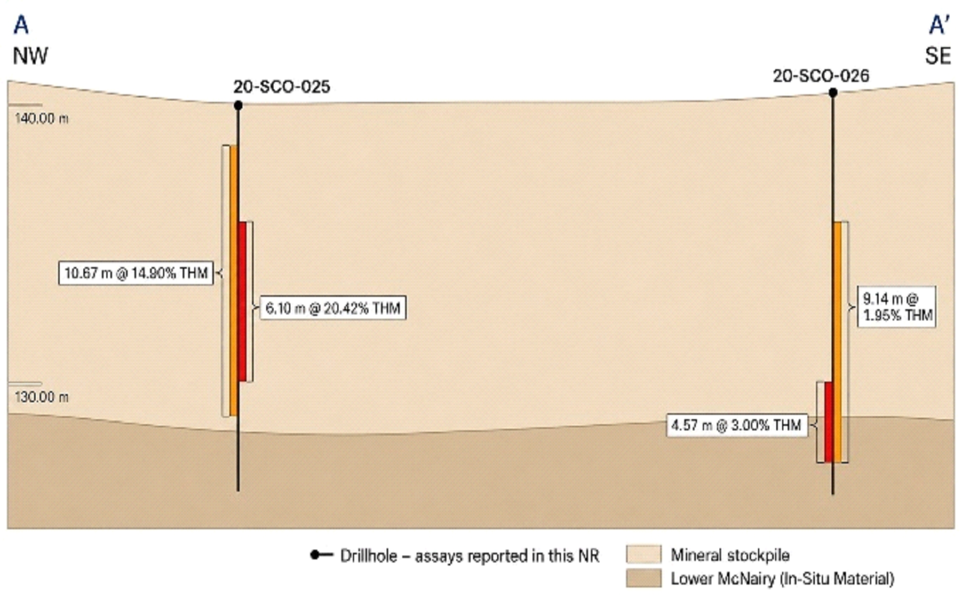
Two 1-ton bulk samples were collected from these pre-processed surface stockpiles in 2020 which returned exceptional grades of 9.9% and 23.0% THM, with
historical drilling indicating depths of approximately 12 meters of mineral stockpiles prior to intersecting the Lower McNairy formation. Subsequent exploration grab sampling in 2025 consistently returned ultra-high-grades of ~20% THM. When compared to the Titan Project’s Resource Estimate of 431 Mt at 2.2% THM, this material represents an outstanding 5x to 10x grade uplift.
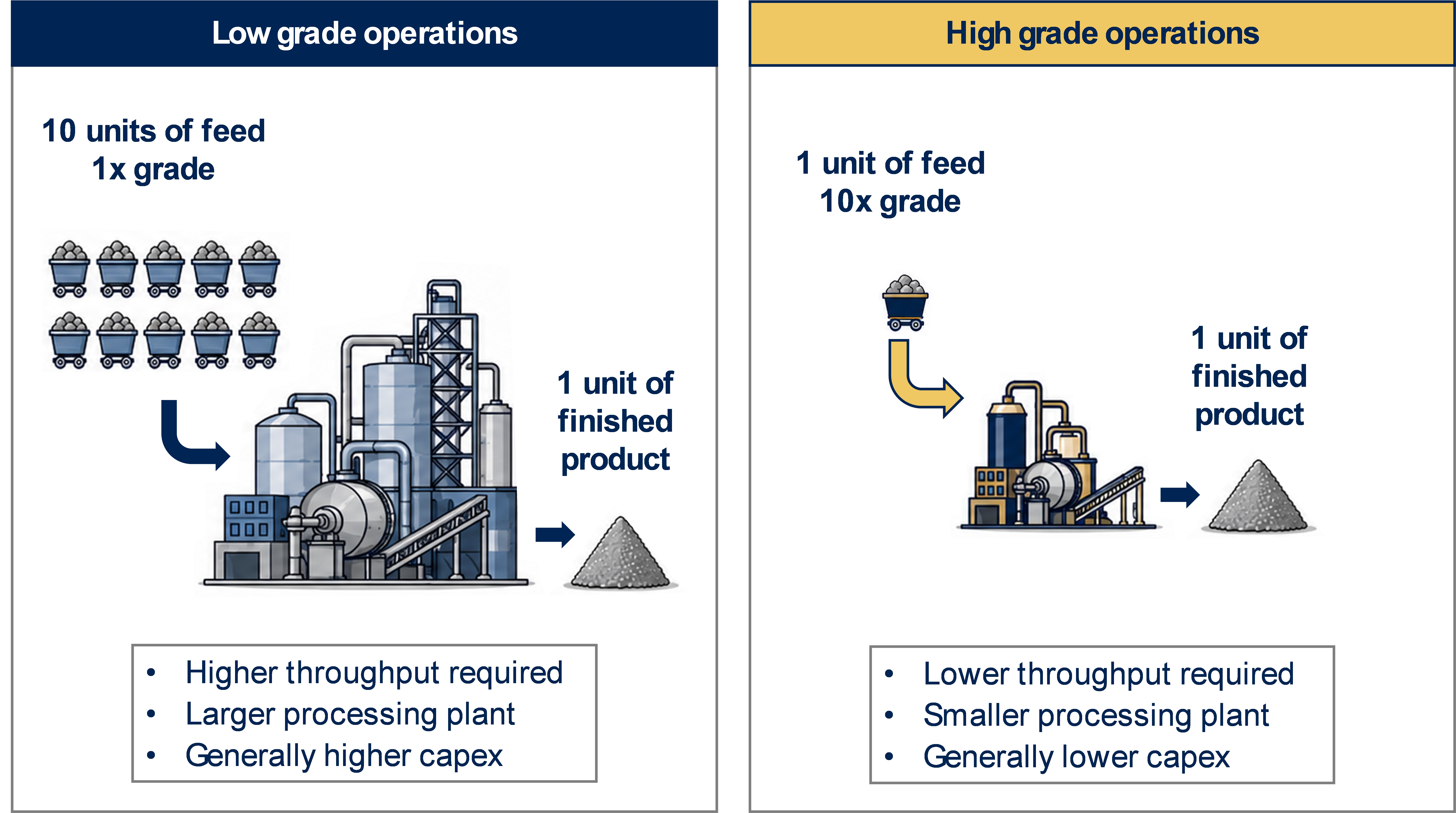
Figure 1: Illustrative example of the potential benefits attributable to high grade feedstocks in mineral extraction and processing operations.
In practical terms, higher-grade feedstock can potentially mean less material needs to be moved and processed to produce a given amount of heavy mineral concentrate. That can be important for
plant size, capital intensity, operating cost and speed to first product, subject to resource definition, metallurgical recoveries, product quality and customer qualification.
This grade advantage also has a very significant impact for the in-situ proportion of the heavy rare earth bearing minerals monazite and xenotime, which are often found in very low
concentrations in mineral sand deposits. The pre-concentrating and stockpiling of these minerals through historic silica operations provides the potential for rare earth values in excess of those found in commercial operations in developments around
the globe. As an example, the grab samples grading at 19% or greater have an average in-situ monazite + xenotime value of approximately 1,100 ppm (along with average in-situ grades of rutile and zircon of 2.1% and 1.1% respectively).
IperionX will accelerate a drilling campaign at Camden to quantify the stockpiled material with the intent of delivering a mineral resource estimate for this material class.
Camden Pre-Stripped Advantage: Ready-access to high-grade Lower McNairy mineralization
Historical mining at Camden effectively removed the overburden ("pre-stripped") across approximately 180 acres, directly exposing the Lower McNairy high-grade mineralized formation – known to be
rich in heavy minerals, including rare earths. At the Titan Project this seam makes up about 70% of the minerals contained within the total mineral resource estimate, with grades of rutile, ilmenite and zircon approximately 2x the concentration of
the Upper McNairy, and grades of rare earths approximately 10x the concentration of the Upper McNairy.
3
The significant amount of pre-stripping allows the potential for rapid mining development of the Lower McNairy formation without incurring significant cost of pre-stripping the overburden as
well as hauling and sorting the related material.
IperionX intends to initiate a drill campaign at Camden in the coming months to quantify the material that has been pre-stripped, with the intent of delivering a mineral resource estimate for
this material class.
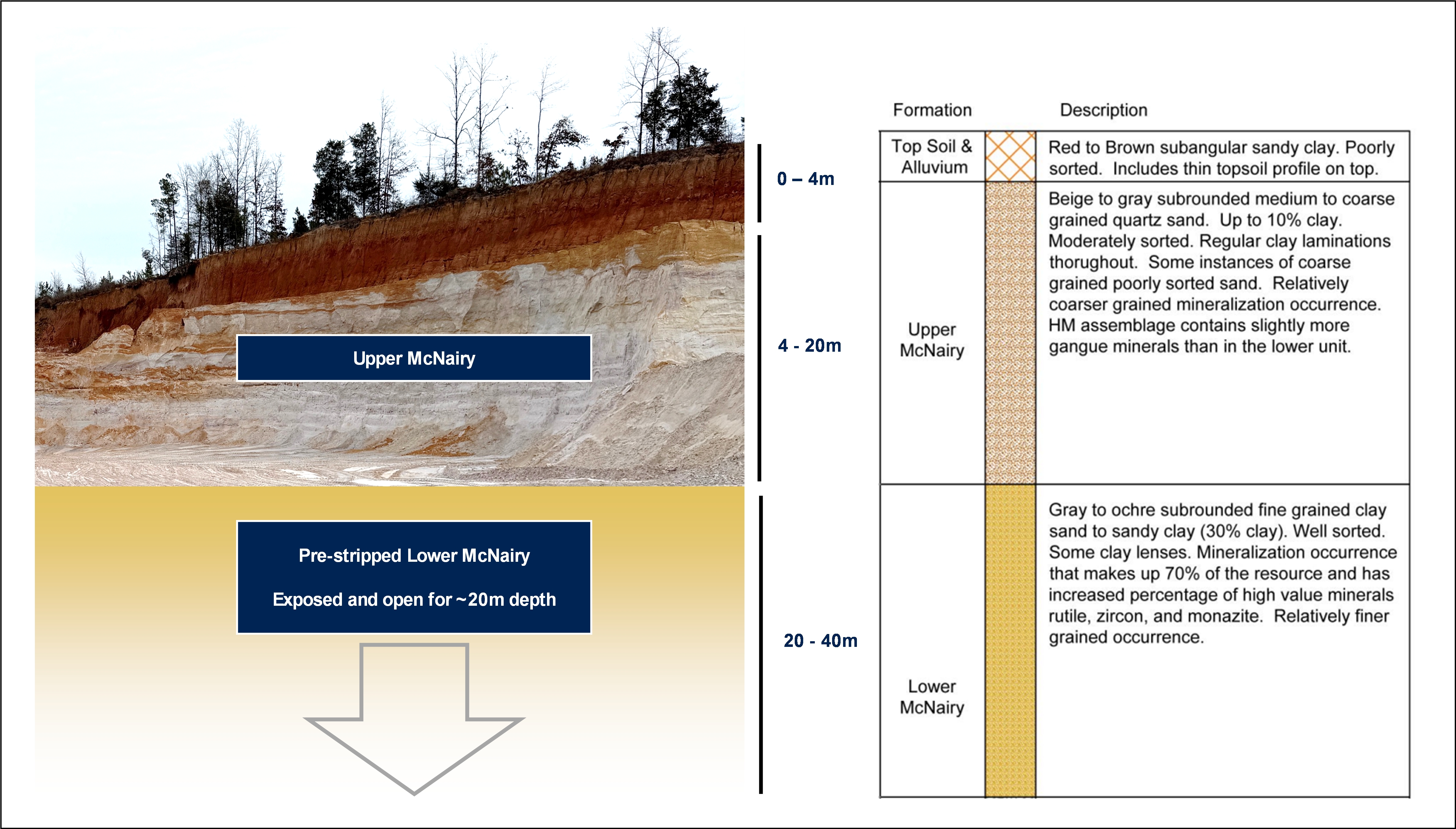
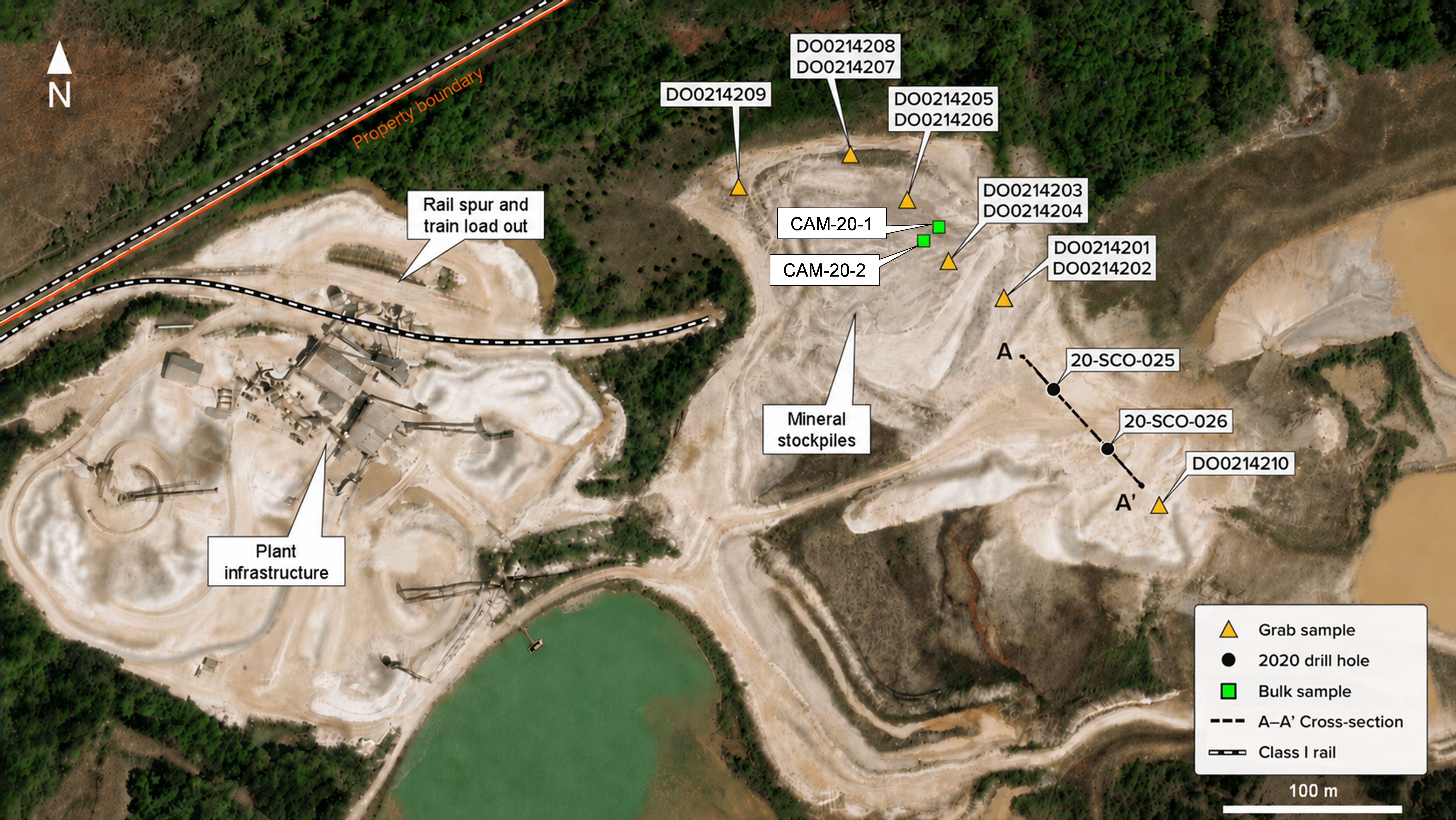
Figure 2: Mining development areas at Camden (upper LHS) highlighting the extensive pre-stripped exposed Lower McNairy formation aligned with the regional stratigraphic column
(RHS).
4
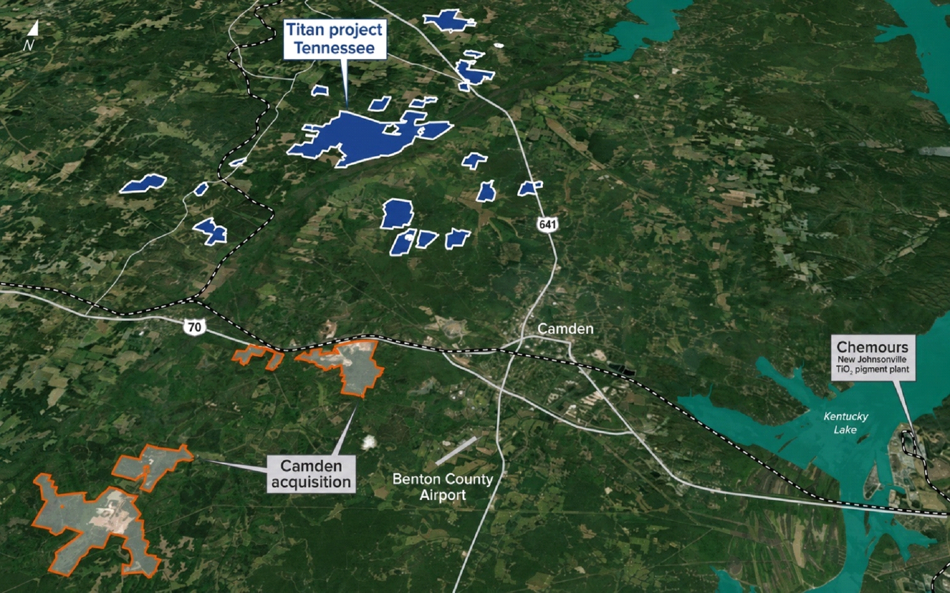
Figure 3: Camden acquisition in relation to the Titan Critical Minerals Project.
Turnkey Infrastructure: De-risking Capex and Timelines
The existing Camden infrastructure is highly strategic as it is an established industrial minerals processing hub with active high-voltage power, industrial-scale water, natural
gas, and heavy-haul rail infrastructure. The potential to integrate Titan's planned mineral processing into Camden's existing infrastructure footprint provides an opportunity to reduce execution risk and capital requirements that are currently included in Titan DFS capital cost build up.
Camden-Titan: The upstream heavy rare earth feedstock platform the U.S. supply chain needs
The United States is rapidly rebuilding its rare-earth-to-magnet supply chain, with growing investment in refining, separation, metallization, alloying and magnet production. Yet one of the most
important vulnerabilities remains upstream: secure domestic heavy rare earth-bearing mineral feedstock.
This is particularly important for dysprosium, terbium and yttrium — heavy rare earths that are vital for high-performance NdFeB magnets used in defense, aerospace, electric vehicles, drones,
robotics and high-temperature advanced technology applications. Without reliable, uninterruptible heavy rare earth-bearing feedstocks, downstream processing and magnet capacity remains exposed to the same strategic supply-chain risk the United States
is working to eliminate.
Camden-Titan is positioned to help address this upstream vulnerability by evaluating a domestic mineral sands platform that uniquely combines:
| ■ |
The large-scale Titan Project with rare earth and critical minerals
|
| ■ |
Ultra-high-grade Camden surface stockpiles
|
| ■ |
Existing turnkey infrastructure
|
| ■ |
Large-scale, pre-stripped, higher-grade Lower McNairy seam access
|
5
| ■ |
Secure, strategically positioned location in Tennessee, USA
|
Subject to resource definition, metallurgical qualification and development studies, Camden-Titan has the potential to become a strategically important U.S.-origin feedstock platform for
titanium, zircon and rare-earth-bearing mineral products. Camden-Titan has the potential to underpin the long-term upstream feedstock foundation needed to support the U.S. buildout of rare earth refining, metal, alloy and magnet capacity.
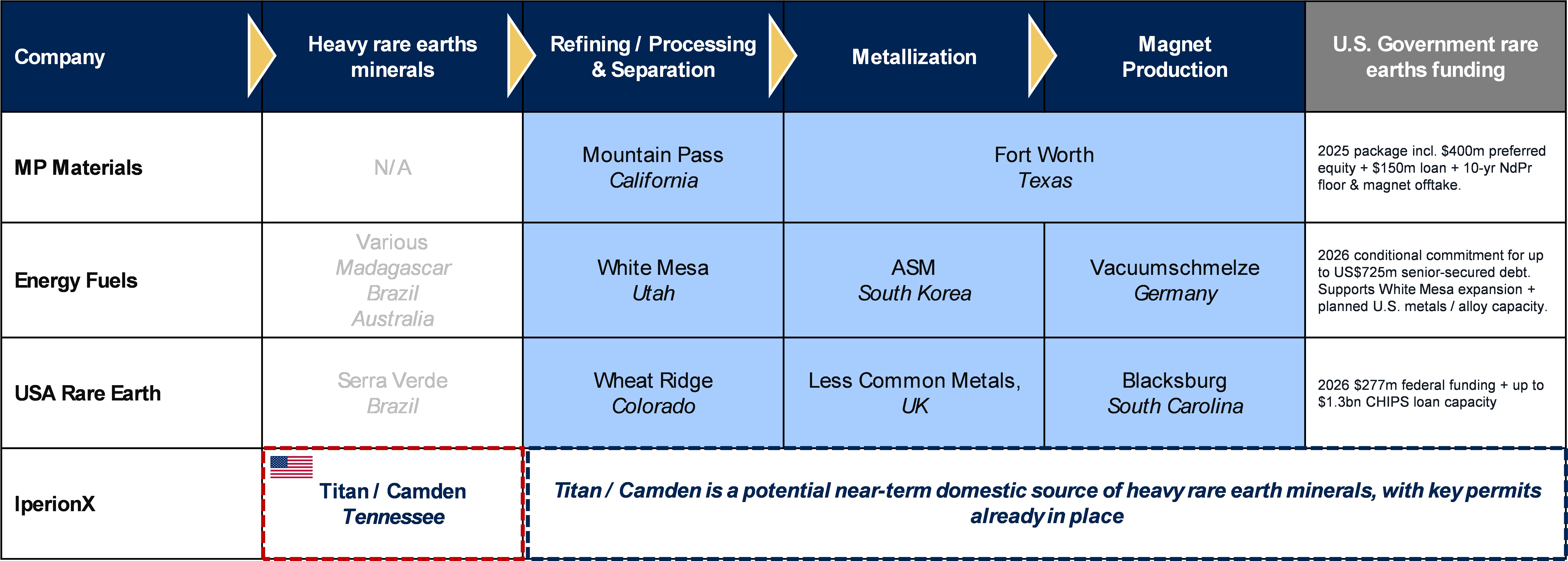
Figure 4: U.S. rare earths supply chain components and associated U.S. Government funding1.
Next steps and development catalysts
IperionX is now advancing a series of techno-economic activities to define the integrated Camden-Titan commercial development pathway. Key 2026 milestones include:
| ■ |
Resource Definition: Sonic drilling of the 70-acre surface stockpiles and 180-acre pre-stripped zones to establish a formal JORC/S-K 1300 compliant Mineral Resource Estimate.
|
| ■ |
Metallurgy: Detailed assemblage analysis to optimize recoveries of titanium, zircon, monazite, and xenotime.
|
| ■ |
Commercial Engagement: Fast-tracked commercial qualification with downstream processors, strategic customers, and U.S. Government stakeholders.
|
| ■ |
Integrated Economic Studies: Delivery of an integrated economic assessment for the development of the Camden-Titan complex.
|
This announcement has been authorized for release by the CEO and Managing Director.
For further information and enquiries please contact:
info@iperionx.com
+1 980 237 8900
1 Source: MP Materials (link), Energy Fuels (link), USA Rare Earths (link)
6
About IperionX
IperionX is a leading American titanium metal and critical materials company – using patented metal technologies to produce high performance titanium alloys, from titanium minerals or scrap
titanium, at lower energy, cost and carbon emissions.
Our Titan critical minerals project is the largest JORC-compliant mineral resource of titanium, rare earth and zircon mineral sands in the United States.
IperionX’s titanium metal and critical minerals are essential for advanced U.S. industries including space, aerospace, defense, consumer electronics, fasteners, automotive and additive
manufacturing.
|
Forward Looking Statements
Information included in this release constitutes forward-looking statements. Often, but not always, forward looking statements can generally be identified by the
use of forward-looking words such as “may”, “will”, “expect”, “intend”, “plan”, “estimate”, “anticipate”, “continue”, and “guidance”, or other similar words and may include, without limitation, statements regarding plans, strategies and
objectives of management, anticipated production or construction commencement dates and expected costs or production outputs.
Forward looking statements inherently involve known and unknown risks, uncertainties and other factors that may cause the Company’s actual results, performance,
and achievements to differ materially from any forecast future results, performance, or achievements. Relevant factors may include, but are not limited to, changes in commodity prices, foreign exchange fluctuations and general economic
conditions, increased costs and demand for production inputs, the speculative nature of exploration and project development, including the risks of obtaining necessary licenses and permits and diminishing quantities or grades of
mineralization, the Company’s ability to comply with the relevant contractual terms to access the technologies, commercially scale its closed-loop titanium production processes, or protect its intellectual property rights, political and
social risks, changes to the regulatory framework within which the Company operates or may in the future operate, environmental conditions including extreme weather conditions, recruitment and retention of personnel, industrial relations
issues and litigation.
Forward looking statements are based on the Company and its management’s good faith assumptions relating to the financial, market, regulatory and other relevant
environments that will exist and affect the Company’s business and operations in the future. The Company does not give any assurance that the assumptions on which forward looking statements are based will prove to be correct, or that the
Company’s business or operations will not be affected in any material manner by these or other factors not foreseen or foreseeable by the Company or management or beyond the Company’s control.
Although the Company attempts and has attempted to identify factors that would cause actual actions, events or results to differ materially from those disclosed in
forward looking statements, there may be other factors that could cause actual results, performance, achievements, or events not to be as anticipated, estimated or intended, and many events are beyond the reasonable control of the Company.
Accordingly, readers are cautioned not to place undue reliance on forward looking statements. Forward looking statements in these materials speak only at the date of issue. Subject to any continuing obligations under applicable law or any
relevant stock exchange listing rules, in providing this information the Company does not undertake any obligation to publicly update or revise any of the forward-looking statements or to advise of any change in events, conditions or
circumstances on which any such statement is based.
Competent Persons Statement
The information in this announcement that relates to Exploration Results is based on, and fairly represents, information compiled and/or reviewed by Mr. Adam
Karst, P.G., a Competent Person who is a Registered Member of the Society of Mining, Metallurgy and Exploration (SME) which is a Recognized Professional Organization (RPO). Mr. Karst is an employee of Karst Geo Solutions, LLC. Mr. Karst has
sufficient experience which is relevant to the style and type of mineralization present at the Titan Project and Camden areas and to the activity that he is undertaking to qualify as a Competent Person as defined in the 2012 edition of the
“Australasian Code for Reporting of Exploration Results, Mineral Resources and Ore Reserves” (the 2012 JORC Code). Mr. Karst consents to the inclusion in this report of the matters based on this information in the form and context in which it
appears.
Compliance Statement
This announcement contains information relating to a Mineral Resource Estimate and an Ore Reserve Estimate for the Titan deposit (where the Mineral Resource
Estimate was prepared by Mr. John Eckman, a Competent Person, and the Ore Reserve Estimate was prepared by Mr. Justin Douthat, also a Competent Person) extracted from an ASX market announcement titled “IperionX Titan DFS Confirms High-Return
U.S. Rare Earths and Critical Minerals Project” and published on the ASX platform (www.asx.com.au) on 4 June 2026. The Company confirms that it is not aware of any new information or data that materially affects the information included in
the original market announcement and that all material assumptions and technical parameters underpinning the estimates in the release of 4 June 2026 continue to apply and have not materially changed. The Company confirms that the form and
context in which the Competent Persons' findings are presented have not been materially modified from the original market announcement.
|
7
Appendix 1 – Exploration results
2020 bulk samples
|
THM Assemblage
|
||||||
|
2020 Sample
|
THM %
|
Rutile
|
Ilmenite
|
Zircon
|
Monazite &
Xenotime
|
Other
|
|
CAM-20-1
|
9.90%
|
12.95%
|
50.47%
|
8.80%
|
1.14%
|
N/A
|
|
CAM-20-2
|
23.00%
|
10.94%
|
36.65%
|
7.84%
|
0.56%
|
N/A
|
2025 grab samples
|
THM Assemblage
|
||||||
|
2025 Sample
|
THM %
|
Rutile
|
Ilmenite
|
Zircon
|
Monazite &
Xenotime
|
Other
|
|
D00214201
|
21.21%
|
10.24%
|
37.12%
|
3.37%
|
0.37%
|
48.91%
|
|
D00214202
|
21.01%
|
10.64%
|
39.62%
|
4.42%
|
0.39%
|
44.93%
|
|
D00214203
|
5.64%
|
10.65%
|
42.31%
|
7.69%
|
0.83%
|
38.52%
|
|
D00214204
|
2.93%
|
10.16%
|
38.85%
|
5.60%
|
0.47%
|
44.92%
|
|
D00214205
|
19.60%
|
10.69%
|
40.00%
|
4.92%
|
0.62%
|
43.78%
|
|
D00214206
|
19.21%
|
10.30%
|
41.52%
|
6.46%
|
0.61%
|
41.11%
|
|
D00214207
|
19.45%
|
10.53%
|
40.67%
|
5.90%
|
0.57%
|
42.33%
|
|
D00214208
|
19.75%
|
11.10%
|
43.90%
|
6.26%
|
0.60%
|
38.13%
|
|
D00214209
|
21.51%
|
10.36%
|
42.28%
|
6.62%
|
0.59%
|
40.15%
|
|
D00214210
|
0.24%
|
7.63%
|
31.79%
|
5.49%
|
0.53%
|
54.56%
|
8
Appendix 2 – 2020 drilling intersections
|
Hole ID
|
Easting
|
Northing
|
Elev.
(m)
|
Az
(°)
|
Dip
(°)
|
Depth
(m)
|
From
(m)
|
To
(m)
|
Intercept
(m)
|
HM
(%)
|
Unit
|
|
20-SCO-025
|
394500.6
|
3989144.7
|
140.8
|
0
|
-90
|
15.2
|
0.0
|
1.5
|
1.5
|
0.19%
|
Tailings
|
|
1.5
|
3.0
|
1.5
|
8.82%
|
Tailings
|
|||||||
|
3.0
|
4.6
|
1.5
|
8.39%
|
Tailings
|
|||||||
|
4.6
|
6.1
|
1.5
|
27.13%
|
Tailings
|
|||||||
|
6.1
|
7.6
|
1.5
|
17.66%
|
Tailings
|
|||||||
|
7.6
|
9.1
|
1.5
|
18.35%
|
Tailings
|
|||||||
|
9.1
|
10.7
|
1.5
|
18.46%
|
Tailings
|
|||||||
|
10.7
|
12.2
|
1.5
|
5.55%
|
Tailings
|
|||||||
|
12.2
|
13.7
|
1.5
|
0.68%
|
Lower McNairy
|
|||||||
|
13.7
|
15.2
|
1.5
|
0.83%
|
Lower McNairy
|
|||||||
|
20-SCO-026
|
394528.5
|
3989118.8
|
141.6
|
0
|
-90
|
15.2
|
0.0
|
1.5
|
1.5
|
0.19%
|
Tailings
|
|
1.5
|
3.0
|
1.5
|
0.38%
|
Tailings
|
|||||||
|
3.0
|
4.6
|
1.5
|
0.37%
|
Tailings
|
|||||||
|
4.6
|
6.1
|
1.5
|
0.93%
|
Tailings
|
|||||||
|
6.1
|
7.6
|
1.5
|
0.74%
|
Tailings
|
|||||||
|
7.6
|
9.1
|
1.5
|
1.02%
|
Tailings
|
|||||||
|
9.1
|
10.7
|
1.5
|
2.30%
|
Tailings
|
|||||||
|
10.7
|
12.2
|
1.5
|
2.10%
|
Tailings
|
|||||||
|
12.2
|
13.7
|
1.5
|
4.62%
|
Lower McNairy
|
|||||||
|
13.7
|
15.2
|
1.5
|
0.43%
|
Lower McNairy
|
9
Appendix 3: JORC Code, 2012 Edition-Table 1 Report
Section 1 Sampling Techniques and Data (Criteria in this section apply to all succeeding sections)
|
Criteria
|
JORC Code Explanation
|
Commentary
|
|||
|
Sampling
Techniques
|
• Nature and quality of sampling (eg cut channels, random chips, or specific specialised industry standard measurement tools appropriate to the minerals under investigation, such as down
hole gamma sondes, or handheld XRF instruments, etc). These examples should not be taken as limiting the broad meaning of sampling.
• Include reference to measures taken to ensure sample representivity and the appropriate calibration of any measurement tools or systems used.
• Aspects of the determination of mineralisation that are Material to the Public Report.
• In cases where ‘industry standard’ work has been done this would be relatively simple (eg ‘reverse circulation drilling was used to obtain 1 m samples from which 3 kg was pulverised to
produce a 30 g charge for fire assay’). In other cases more explanation may be required, such as where there is coarse gold that has inherent sampling problems. Unusual commodities or mineralisation types (eg submarine nodules) may warrant
disclosure of detailed information.
|
• A roto-sonic drill rig, the Geoprobe 5140LS, utilized a 10-foot core barrel to obtain direct 5-foot samples of the unconsolidated tailings material hosting the mineralization in the
northern mining area. All holes were drilled vertically. As tailings are not in-situ material there is no preferred orientation. The sonic cores were used to produce approximately 2kg samples for heavy liquid separation.
• Grab samples were collected using a hand trowel at the surface and approximately 1 foot depth below surface at tailings pile. Samples were approximately 2kg each for heavy liquid
separation.
• Samples CAM-20-1 and CAM-20-2 were collected from the silica mine facility in Camden, TN. The samples were collected in 2020 from the facility’s tailings deposits. Due to Covid
protocols and travel restrictions, the samples were collected by personnel of the property’s prior owners under close communication with IperionX’s consulting geologist, Lamont Leatherman. The actual sample collection was by mechanical
equipment, the material was collected in a super sack, labelled and prepared for transport. Approximately 1 imperial ton of sand tailings was collected for each sample, the two samples were shipped to Overburden Drilling Management (ODM)
for sample processing.
|
|||
|
Drilling
Techniques
|
• Drill type (eg core, reverse circulation, open-hole hammer, rotary air blast, auger, Bangka, sonic, etc) and details (eg core diameter, triple or standard tube, depth of diamond
tails, face-sampling bit or other type, whether core is oriented and if so, by what method, etc).
|
• All drilling has been roto-sonic. This method alternates advancement of a core barrel and a removable casing. The core barrel utilized for this project is 4” in diameter with a 6”
diameter outer casing. The core barrel is retrieved from the ground, and the samples are recovered directly from the barrel into a plastic sleeve. All holes are drilled vertically.
• No drilling techniques were used to obtain the 10 grab samples and larger, samples CAM-20-1 and CAM-20-2.
|
|||
|
Drill
Sample
Recovery
|
• Method of recording and assessing core and chip sample recoveries and results assessed. • Measures taken to maximise sample recovery and ensure representative nature of the samples. •
Whether a relationship exists between sample recovery and grade and whether sample bias may have occurred due to preferential loss/gain of fine/coarse material
|
• Each core is measured, and the recovery is calculated as length of recovered core divided by length drilled (typically 10’). Some interpretation is involved as the material can
expand or compact as it is recovered from the core barrel into the plastic sleeve.
• The driller and geologist keep a careful eye on tailings run-up into the casing as the core barrel is run down the hole for sample collection. Any run-up is removed from the casing
prior to sampling.
• The sonic drilling method has been shown to provide representative unconsolidated mineral sands samples across a variety of deposits as it is a direct sampling method of tailings. At
times water is used to create a head on the formation to help prevent run-up.
• N/A for 10 grab samples and CAM-20-1 and CAM-20-2.
|
|||
|
Logging
|
• Whether core and chip samples have been geologically and geotechnically logged to a level of detail to support appropriate Mineral Resource estimation, mining studies and
metallurgical studies.
• Whether logging is qualitative or quantitative in nature. Core (or costean, channel, etc) photography.
• The total length and percentage of the relevant intersections logged.
|
• Both drilling and grab samples are logged for lithological, geological, and mineralogical parameters in the field to help aid in determining thickness of tailings material to in-situ
formation material. All samples are panned and estimates made for the %HM and %SL.
• Logging is both qualitative (sorting, color, lithology) and quantitative (estimation of %HM, %SL) to help support the integrity of the Exploration Results. Photographs are taken of
sonic cores. No photos were taken of grab samples.
|
10
|
• Total depth of the drillhole is recorded. Samples are collected at regular (5 foot) intervals unless the geology/mineralogy warrant altering this as to co-mingle samples across major
geological/mineralized boundaries. The total hole is logged by the field geologist and recorded in custom logging software on a Panasonic Toughbook (or similar) laptop. The data is transferred weekly to the project’s GeoSpark database.
• Grab samples were taken at discrete intervals and data was logged into a field computer and transferred to QGIS for spatial analysis.
• Samples CAM-20-1 and CAM-20-2 were not logged but were described as sand tailings from the company’s flotation concentration plant.
|
|||||
|
Sub-
Sampling
Techniques
and
Sample
Preparation
|
• If core, whether cut or sawn and whether quarter, half or all core taken.
• If non-core, whether riffled, tube sampled, rotary split, etc and whether sampled wet or dry.
• For all sample types, the nature, quality and appropriateness of the sample preparation technique.
• Quality control procedures adopted for all sub-sampling stages to maximise representivity of samples.
• Measures taken to ensure that the sampling is representative of the in situ material collected, including for instance results for field duplicate/second-half sampling.
• Whether sample sizes are appropriate to the grain size of the material being sampled.
|
• The unconsolidated sonic cores are sampled by splitting the core in half lengthwise using a machete then recovering an even fillet with a trowel along the entire length of the sample
interval.
• Samples are collected directly to the pre-labeled/pre-tagged sample bags; the remaining sample is further split into a replicate/archival sample and what remains is used to backfill
the drillhole.
• A chip tray is maintained for each hole to keep a representative sample for each interval for later use during geological interpretation or between holes in the field.
• No field duplicates were taken for this exploration campaign. No QA/QC procedures were implemented for grab samples, drill holes, or larger CAM-20-1 and CAM-20-2 samples.
• The sample size (approx. 2kg) is appropriate for the type of material and concentration of the HM mineralization.
• For samples CAM-20-1 and CAM-20-2 ODM reported that one approximately 10 kg representative subsample was taken from each bulk sample. The subsamples were collected by recovering a
vertical column or “core” at the center of the super sack to ensure a representative sample. approximately 1 imperial ton sand tailings sample and dried. The laboratory photographic record shows low-temperature oven drying. The process used
three shaking-table passes, followed by heavy liquid separation at S.G. 2.96 to produce HMC.
|
|||
|
Quality of
Assay Data
and
Laboratory
Results
|
• The nature, quality and appropriateness of the assaying and laboratory procedures used and whether the technique is considered partial or total.
• For geophysical tools, spectrometers, handheld XRF instruments, etc, the parameters used in determining the analysis including instrument make and model, reading times, calibrations
factors applied and their derivation, etc.
• Nature of quality control procedures adopted (eg standards, blanks, duplicates, external laboratory checks) and whether acceptable levels of accuracy (ie lack of bias) and precision
have been established.
|
• Standard mineral sands industry assay procedures (sizing 44-micron [325 mesh] for slimes and 595-micron [30 mesh] for oversize) heavy-liquid separation of an 85g split of the
-30/+325 sand using methylene iodide. Drill hole samples utilized dry screening as a prerequisite to HLS whereas surface “grab samples” utilized wet screening. As these are pre-processed tailings the screening methods difference is not
material to this study. Further exploration activity in this area will be wet screened prior to HLS. No mineralogical assays were utilized for the drill campaign.
• Accuracy monitoring will be achieved through submission of in-house heavy mineral sand standard reference materials (SRM) developed specifically for the project. However, for the
grab samples, drill holes, and larger, CAM-20-1 and CAM-20-2 samples no SRMs were submitted.
• THM is calculated internally using HLS data:
o (HLS Sink [%]/100*(-600/45um/[wt/g])/
(Calculated Total [wt/g])
• QEMSCAN (Quantitative Evaluation of Minerals by Scanning Electron Microscopy) is the state of the art, top of the range automated mineral
analyser. It is an analytical tool that produces efficient and accurate information on minerals. This tool has been customized for the mining industry.
|
11
|
• The Valuable Heavy Mineral (VHM) is calculated from the QEMSCAN data using the percent of rutile+leucoxene+pseudorutile+ilmenite+zircon+REE in the sink fraction of the sample for the
grab samples. No QEMSCAN was completed for drill samples.
• For samples CAM-20-1 and CAM-20-2 the samples were processed by Overburden Drilling Management Limited. The reported results are total heavy mineral concentrate (HMC) yields from
gravity concentration and heavy liquid separation, not chemical assays. HMC was produced using shaker table and heavy liquid separation at S.G. 2.96. No QAQC materials were submitted with the two bulk samples.
|
|||||
|
Verification
of
Sampling
and
Assaying
|
• The verification of significant intersections by either independent or alternative company personnel.
• The use of twinned holes.
• Documentation of primary data, data entry procedures, data verification, data storage (physical and electronic) protocols.
• Discuss any adjustment to assay data.
|
• The assay data are independently visually validated and cross-checked against the geology. This is done as the results are received and prior to geological modeling and resource
estimation.
• Twinned holes have not been used. Analysis of twin data for other similar deposits indicates that they are of limited value due to the inherent variability over small distances for
this style of mineralization and it is the assessment of the Competent Person that the absence of twin data is not material to the accuracy of the Exploration Results and Resource Estimate. Twinned holes will be used if there is a change in
drilling methods during the project to assess whether any bias exists with the different methods and how this bias may impact the integrity of the Exploration Results or Mineral Resource Estimate.
• Data is collected in the field using both a field computer and a field notebook. Data are then transferred to the company network and verified against the field logbook if questions
arise. The data are checked and verified by the geologist completing the resource estimation to ensure there are no errors. Lab data are added as they become available and verified against the field geologist’s visual HM grade and SL
estimates. Any data in question that cannot be rectified is removed from the database and not used in the reporting of Exploration Results.
• The data appears to be in good order with no significant quality issues identified that will be material to the Exploration Results.
• For samples CAM-20-1 and CAM-20-2 the numerical results for the total heavy mineral content have been transcribed from the ODM final laboratory report. Due to Covid travel
restrictions, the IperionX geologists could not visit the lab during processing. No independent verification or repeat test work is provided.
|
|||
|
Location of
Data Points
|
• Accuracy and quality of surveys used to locate drill holes (collar and down-hole surveys), trenches, mine workings and other locations used in Mineral Resource estimation.
• Specification of the grid system used.
• Quality and adequacy of topographic control.
|
• All drillholes are surveyed after drilling with a hand-held GPS unit and the X and Y coordinates recorded in the project’s database by the field geologist. Elevation data for each
collar has been determined using publicly available topographic data.
• Grab samples utilized a handheld QFIELD GPS unit and the X and Y coordinates recorded in the project’s database by the field geologist. Elevation data for each collar has been
determined using publicly available topographic data.
• For samples CAM-20-1 and CAM-20-2 collection took place within 50 feet of the concentrator facilities active tailings stacker. UTMs were extracted from the description communicated
by personnel of the property’s prior owners. The UTM are in projection zone.
• The coordinate system used for the project is UTM (Zone16N).
|
|||
|
Data
Spacing
and
Distribution
|
• Data spacing for reporting of Exploration Results.
|
• Drillhole spacing varies at this early point in the project. Drill samples are collected at regular intervals (5 foot).
|
12
|
• Whether the data spacing and distribution is sufficient to establish the degree of geological and grade continuity appropriate for the Mineral Resource and Ore Reserve estimation
procedure(s) and classifications applied.
• Whether sample compositing has been applied.
|
• Compositing of samples downhole in relation to mineralized tailings areas may be of use in future exploration.
• Grab samples were taken on a transect line at random spacing. These results alone are not sufficient to support Mineral Resource Estimation.
• Only two CAM-20 sample results are supplied. No spacing, sampling grid, sample population, representivity or compositing information is provided. These results alone are not
sufficient to support Mineral Resource estimation
|
||||
|
Orientation
of Data in
Relation to
Geological
Structure
|
• Whether the orientation of sampling achieves unbiased sampling of possible structures and the extent to which this is known, considering the deposit type.
• If the relationship between the drilling orientation and the orientation of key mineralised structures is considered to have introduced a sampling bias, this should be assessed and
reported if material.
|
• The drilling and sampling have been orientated to test the thickness and grade of the tailings pile. Holes are drilled vertically to give true thickness of the dumping zones in
relation to true subsurface McNairy Sand.
• Grab samples have not been oriented to test thickness of the tailings pile. Rather their purpose is to derive a first pass view of tailings total heavy mineral % and assemblage.
• The CAM-20-1 and CAM-20-2 samples are spot bulk samples from the mine concentrator tailings deposits, these samples are indicative only and were not designed to produce an average
grade of the tailings deposits on the property. Not applicable or unknown from the supplied documents because sample provenance and geological geometry are not provided.
|
|||
|
Sample
Security
|
• The measures taken to ensure sample security.
|
• Drill samples and Grab samples remained in the custody of the field geologist from time of collection until time of delivery to the project’s temporary storage location which is a
secure third-party storage unit.
• Drill samples and Grab samples were placed in rice bags and a red security tag secure the top. These tags are verified by the lab to guarantee all sample bags are intact.
• Samples CAM-20-1 and CAM-20-2 were sealed at the mine site by personnel of the of the property’s prior owners. Sample transport, storage or laboratory receipt information is
provided.
|
|||
|
Audits or
Reviews
|
• The results of any audits or reviews of sampling techniques and data.
|
• No third-party review of the sampling techniques employed has been conducted. Only internal reviews by the Competent Person who is considered to have expertise in the
drilling/sampling methods has been utilized.
• No audits or independent reviews are described in the supplied documents for samples CAM-20-1 and CAM-20-2.
|
Section 2: Reporting of Exploration Results (Criteria listed in the preceding section also apply to this section)
|
Criteria
|
JORC Code Explanation
|
Commentary
|
|||
|
Mineral
Tenement
and Land
Tenure Status
|
• Type, reference name/number, location and ownership including agreements or material issues with third parties such as joint ventures, partnerships, overriding royalties, native title
interests, historical sites, wilderness or national park and environmental settings.
• The security of the tenure held at the time of reporting along with any known impediments to obtaining a licence to operate in the area.
|
• All areas reported are owned or controlled by IperionX.
• The supplied ODM report identifies the client as TN Exploration (a subsidiary of IperionX) and the project as Heavy Mineral Sands. IperionX has applicable tenement, mineral rights,
land ownership, permits, leases, to the properties in Camden TN.
|
|||
|
Exploration
Done by Other
Parties
|
• Acknowledgment and appraisal of exploration by other parties.
|
• Several Heavy Mineral Sand (HMS) exploration campaigns have focused on this region over the past 60 years, with DuPont reportedly being the first company to investigate this region,
followed by Kerr-McGee Chemical Corporation that had exploration success but never commenced mining. BHP Titanium Minerals had an interest in the region in the 1990s and Mineral Recovery Systems, a company associated with Altair International
Inc., had significant activities in the region in the late 1990s, including land acquisition, drilling and metallurgical studies.
|
13
|
• The properties have been explored and mined for silica sand in the McNairy Formation. The mine has produced high quality sand from the late 1920s to 2026. Regionally, the McNairy
Formation is Cretaceous in age and has hosted several heavy mineral sand exploration campaigns by both major and junior exploration companies.
• Recent Exploration of Tailings within the northern properties began in 2015 internally by the property’s prior owners.
• In 2021 IperionX released a HM sands mineral resource estimate at the Titan Project and in June 2026 released a DFS for the deposit.
|
|||||
|
Geology
|
• Deposit type, geological setting and style of mineralisation.
|
• Tailings material is derived from the Upper McNairy Sand unit within the McNairy Sand Formation. Sands were “dumped” refuse material from operational plant that was been maintained by
the property’s prior owners.
• The Camden and Little Benton deposits are Cretaceous mineral sands deposits located in the Mississippi Embayment region of the U.S. These deposits consist of reworked deltaic
sediments hosting HM mineralization. The deposits overlie other deeper marine sediments and are overlain by more recent fluvial sediments.
|
|||
|
Drill Hole
Information
|
• A summary of all information material to the understanding of the exploration results including a tabulation of the following information for all Material drill holes:
o easting and northing of the drill hole collar
o elevation or RL (Reduced Level – elevation above sea level in metres) of the drill hole collar
o dip and azimuth of the hole
o down hole length and interception depth
o hole length.
• If the exclusion of this information is justified on the basis that the information is not Material and this exclusion does not detract from the understanding of the report, the
Competent Person should clearly explain why this is the case.
|
• A total of 2 drill holes for 10 HM assay samples (heavy liquid) have been completed to-date. A summary of representative HM intersections from the drilling is presented in tables in
the main text and in the below cross section(s). Refer to table in main text.
• No drill holes or intervals are reported for the Grab Samples or samples CAM-20-1 and CAM-20-2.
 |
|||
|
Data
Aggregation
Methods
|
• In reporting Exploration Results, weighting averaging techniques, maximum and/or minimum grade truncations (eg cutting of high grades) and cut-off grades are usually Material and
should be stated.
• Where aggregate intercepts incorporate short lengths of high grade results and longer lengths of low grade results, the procedure used for such aggregation should be stated and some
typical examples of such aggregations should be shown in detail.
• The assumptions used for any reporting of metal equivalent values should be clearly stated.
|
• No lower cut-offs have been applied.
• Sample interval lengths are typically 5 feet for drill samples.
• No metal equivalent values are used in this report.
|
|||
|
Relationship
Between
Mineralisation
Widths and
Intercept
Lengths
|
• These relationships are particularly important in the reporting of Exploration Results.
|
• Drillholes are vertical and drilled from ground surface through the entire mineralized thickness terminating in the in-situ Lower McNairy.
|
14
|
• If the geometry of the mineralisation with respect to the drill hole angle is known, its nature should be reported.
• If it is not known and only the down hole lengths are reported, there should be a clear statement to this effect (eg ‘down hole length, true width not known’).
|
• Any geological units identified in this study are near flat lying (slight westward dip) so mineralized thicknesses are close to true.
• N/A for CAM-20-1 and CAM-20-2. Samples reported are spot checks only and considered as indicative only with regards to grade of the tailings deposits.
|
||||
|
Diagrams
|
• Appropriate maps and sections (with scales) and tabulations of intercepts should be included for any significant discovery being reported. These should include, but not be limited to
a plan view of drill hole collar locations and appropriate sectional views.
|
• Figure below.
• No sample location map, cross-section or processing flowsheet is provided in the supplied source documents for samples CAM-20-1 and CAM-20-2. The laboratory photographic record
provides processing photographs but no location diagrams.
 |
|||
|
Balanced
Reporting
|
• Where comprehensive reporting of all Exploration Results is not practicable, representative reporting of both low and high grades and/or widths should be practiced to avoid misleading
reporting of Exploration Results.
|
• Representative reporting of low and high grades has been employed within this report.
• For samples CAM-20-1 and CAM-20-2 only two samples are collected and reported. The samples are spot checks only and are considered as indicative only with regards to grade of the
tailings deposits.
|
|||
|
Other
Substantive
Exploration
Data
|
• Other exploration data, if meaningful and material, should be reported including (but not limited to): geological observations; geophysical survey results; geochemical survey results;
bulk samples – size and method of treatment; metallurgical test results; bulk density, groundwater, geotechnical and rock characteristics; potential deleterious or contaminating substances.
|
• At the base of the Tailings pile thickness a layer of hydrocarbon fluid has been observed and should be noted.
• Approximately 10 km north northwest of the property, IperionX has completed a JORC compliant mineral resource estimate (MRE) along with a DFS and ore reserve. The IperionX MRE is
hosted in the McNairy Formation, the same formation that hosts the property’s mine site. Heavy minerals in IperionX’s deposit include zircon, rutile, ilmenite and REEs.
 |
|||
|
Further Work
|
• The nature and scale of planned further work (eg tests for lateral extensions or depth extensions or large-scale step-out drilling).
|
• Additional grid-line spaced drilling within the Tailings area is recommended and should be pursued as well as additional site mapping of the area to identify the true boundaries of
the Tailings pile as well as any others in the area.
|
15
|
• Diagrams clearly highlighting the areas of possible extensions, including the main geological interpretations and future drilling areas, provided this information is not commercially
sensitive.
|
• Surficial sampling took place in 2025 which is included in this report.
• Further work should focus on a complete evaluation of the tailings deposits on the property via drilling and / or trenching. The objective of this program should be a JORC compliant
heavy mineral resource for the tailings deposits. A secondary objective would be to explore the property and if appropriate, develop a JORC compliant heavy mineral resource for the remaining portions of the McNairy Formation confirming
provenance and representivity, verifying sample locations and chain of custody, repeating or duplicating HMC test work, adding quantitative mineralogy and chemical assays, and documenting the project/geological context for IperionX.
|
16