
Exhibit 96.1
Initial Assessment & Technical Report Summary on the Itarantim REE Project, Brazil in accordance with S-K 1300
|
Prepared for
IMC Rare Earths Ltd | |
Effective Date March 31, 2025 | ||
Signature Date April 9, 2026 | ||
report no. R257.2025 | ||
Reference IMCMRE01 | ||
PREPARED BY ERM Australia Consultants Pty Ltd |
DOCUMENT INFORMATION
Report Prepared for
| Document Title | Initial Assessment & Technical Report Summary on the Itarantim REE Project, Brazil |
| Project Number | IMCMRE01 |
| Date | April 9, 2026 |
| Author | ERM Australia Consultants Pty Ltd |
| Client Name | IMC Rare Earths Ltd |
| Client Contact and Title | Francesco Scolaro (Director) |
| Client Office Address | Avenida Paulista, 1765, 7th Floor São Paolo, São Paolo, 0311-930, Brazil |
Report Issued by
| Office | Address |
ERM
Australia ACN 003 687 581 |
Level 3, 1-5 Havelock Street West Perth WA 6005 AUSTRALIA T +61 8 9355 1677 |
| Page i |
Author Details and Signature page
Initial Assessment & Technical Report Summary on the Itarantim REE Project, Brazil, in accordance with S-K 1300
Prepared by Qualified Persons from the following Third-Party Company:
/s/ ERM Australia Consultants Pty Ltd
ERM Australia Consultants Pty Ltd
January 16, 2026
© Copyright 2026 by The ERM International Group Limited and/or its affiliates (‘ERM’). All Rights Reserved.
Except as required pursuant to U.S. federal securities laws or regulations, no part of this work may be reproduced or transmitted in any form or by any means, without prior written permission of ERM.
| Page ii |
ABBREVIATIONS AND UNITS OF MEASUREMENT
| Abbreviation/Unit | Description |
| °C | degrees Celsius |
| °F | degrees Fahrenheit |
| 3D | three-dimensional |
| Aerosat | Aerosat Engenharia e Aerolevantamentos Ltda |
| ALS | ALS Global |
| ANM | Agência Nacional de Mineração |
| Cacto Geologia | Cacto Geologia Mineração e Meio Ambiente Ltda |
| CAGR | compound annual growth rate |
| Ce | Cerium |
| CFEM | Compensação Financeira por Exploração Mineral |
| CIA | Chemical Index of Alteration |
| cm | centimeters |
| CPRM | Companhia de Pesquisa de Recursos Minerais (now Serviço Geológico do Brasil or Geological Survey of Brazil) |
| CRM | certified reference material |
| DTM | digital terrain model |
| Dy | Dysprosium |
| ERM | ERM Australia Consultants Pty Ltd |
| ESG | environmental, social and governance |
| g | grams |
| g/t | grams per tonne |
| GPS | global positioning system |
| ha | hectares |
| HCl | hydrogen chloride |
| HREO | heavy rare earth oxides |
| IAC | ionic adsorption clay |
| ICP | inductively coupled plasma (assay) |
| ICP-AES | inductively coupled plasma-atomic emission spectroscopy |
| ICP-MS | inductively coupled plasma-mass spectrometry |
| IMC | IMC Rare Earths Ltd |
| IMC Holdings | International Mineral Corporation Holdings Ltd |
| kg | kilograms |
| km | kilometers |
| km2 | square kilometers |
| LiDAR | light detection and ranging |
| LREO | light rare earth oxides |
| m | meter(s) |
| M | million(s) |
| Ma | million years before present |
| mm | millimeters |
| MRE | Mineral Resource estimate |
| MREO | magnet MREO |
| Mt | million tonnes |
| NaCl | sodium chloride |
| Page iii |
| ITARANTIM REE PROJECT, BRAZIL, TECHNICAL REPORT SUMMARY | R257,2025 |
| Nd | neodymium |
| Niobium Brazil | Niobium Brazil Importacao e Exportacao Ltda |
| NIR | near infrared spectroscopy |
| OREAS | ORE Research & Exploration Pty Ltd |
| ppm | parts per million |
| Pr | praseodymium |
| QAQC | quality assurance/quality control |
| QP | Qualified Person |
| REE | rare earth element |
| REO | rare earth oxide |
| RPEE | reasonable prospects for economic extraction |
| RTK | real-time kinematic |
| SD | standard deviation |
| SEC | (United States) Securities and Exchange Commission |
| SEM | Scanning Electron Microscope |
| SGS | SGS Laboratory |
| SOP | standard operating procedure |
| SPT | Standard Penetration Test |
| SRTM | Shuttle Radar Topography Mission |
| t | tonnes |
| t/m3 | tonnes per cubic metre |
| Tb | terbium |
| TbDy | heavy MREO |
| TREO | total rare earth oxide(s) |
| TRS | Technical Report Summary |
| US | United States (of America) |
| USD | United States of America dollars |
| XRD | x-ray diffraction |
| Page iv |
| ITARANTIM REE PROJECT, BRAZIL, TECHNICAL REPORT SUMMARY | R257,2025 |
CONTENTS
| DOCUMENT INFORMATION | I | |
| AUTHOR DETAILS AND SIGNATURE PAGE | II | |
| ABBREVIATIONS AND UNITS OF MEASUREMENT | III | |
| 1. | EXECUTIVE SUMMARY | 1 |
| 1.1 | Introduction | 1 |
| 1.2 | Property Description (including Mineral Rights) and Ownership | 1 |
| 1.2.1 Mineral Rights under the Brazilian Mining Code | 1 | |
| 1.3 | Accessibility, Climate and Physiography | 2 |
| 1.4 | History | 3 |
| 1.5 | Geology and Mineralization | 3 |
| 1.5.1 Regional and Local Geology | 3 | |
| 1.5.2 Mineralization and Deposit Style | 3 | |
| 1.6 | Status of Exploration and Drilling | 4 |
| 1.7 | Sampling, Analyses and Security | 5 |
| 1.8 | Data Verification | 5 |
| 1.9 | Mineral Processing and Metallurgical Testing | 5 |
| 1.10 | Mineral Resource Estimate | 6 |
| 1.10.1 Data Inputs, Domain Modeling, and Compositing | 6 | |
| 1.10.2 Statistics, Geostatistics and Density | 6 | |
| 1.10.3 Block Model Parameters, Estimation Methodology and Validation | 7 | |
| 1.11 | Mineral Resource Reporting | 7 |
| 1.11.1 Initial Assessment and Reasonable Prospects for Economic Extraction | 7 | |
| 1.11.2 Mineral Resource Estimate Classification | 7 | |
| 1.11.3 Mineral Resource Statement | 9 | |
| 1.12 | Interpretation and Conclusions | 9 |
| 1.13 | Recommendations | 9 |
| 2. | INTRODUCTION | 11 |
| 2.1 | Registrant and Terms of Reference | 11 |
| 2.2 | Principal Sources of Information | 11 |
| 2.3 | Qualified Persons | 11 |
| 2.4 | Site Visit and Personal Inspection | 11 |
| 3. | PROPERTY DESCRIPTION | 12 |
| 3.1 | Location of Project | 12 |
| 3.2 | Exploration Permits, Mineral Rights and Surface Rights | 13 |
| 3.2.1 Mineral Rights under the Brazilian Mining Code | 14 | |
| 3.3 | Royalties | 15 |
| 3.4 | Environmental Liabilities | 15 |
| 3.5 | Significant Encumbrances to the Property | 15 |
| 3.6 | Other Significant Factors and Risks | 15 |
| Page v |
| ITARANTIM REE PROJECT, BRAZIL, TECHNICAL REPORT SUMMARY | R257,2025 |
| 4. | ACCESSIBILITY, CLIMATE, LOCAL RESOURCES, INFRASTRUCTURE AND PHYSIOGRAPHY | 16 |
| 4.1 | Topography and Physiography | 16 |
| 4.2 | Climate | 16 |
| 4.3 | Accessibility, Vegetation, and Local Industry | 17 |
| 4.4 | Local Resources and Infrastructure | 17 |
| 5. | HISTORY | 18 |
| 5.1 | Project and Exploration History | 18 |
| 5.2 | Historical Production | 18 |
| 6. | GEOLOGICAL SETTING, MINERALIZATION AND DEPOSIT | 19 |
| 6.1 | Regional and Local Geology | 19 |
| 6.1.1 Regional Geology | 19 | |
| 6.1.2 Local Geology | 19 | |
| 6.2 | Property Geology | 19 |
| 6.3 | Deposit Type | 20 |
| 6.4 | Mineralization | 20 |
| 6.4.1 Weathering | 21 | |
| 6.4.2 Factors Affecting Continuity of Grade and Geology | 22 | |
| 7. | EXPLORATION | 23 |
| 7.1 | Exploration History | 23 |
| 7.1.1 Geophysics | 23 | |
| 7.1.2 Soil Sampling | 23 | |
| 7.1.3 Trenching | 25 | |
| 7.1.4 Significant Results and Interpretation | 25 | |
| 7.2 | Drilling | 26 |
| 7.2.1 Drilling Techniques and History | 26 | |
| 7.2.2 Sampling Techniques and Sample Recovery | 29 | |
| 7.3 | Logging | 31 |
| 7.4 | Location of Data Points | 31 |
| 7.4.1 Topography Data | 31 | |
| 7.4.2 Collar Data | 31 | |
| 7.4.3 Downhole Survey Data | 32 | |
| 7.5 | Data Spacing and Orientation | 32 |
| 7.6 | Orientation in Relation to Geological Structure | 32 |
| 7.7 | Material Results and Interpretation | 32 |
| 7.8 | Hydrogeology | 33 |
| 7.9 | Geotechnical | 33 |
| 8. | SAMPLE PREPARATION, ANALYSES AND SECURITY | 34 |
| 8.1 | Subsampling Techniques and Sample Preparation | 34 |
| 8.1.1 Itarantim Sample Yard | 34 | |
| 8.2 | Sample Analyses | 35 |
| 8.2.1 Summary | 35 | |
| 8.2.2 SGS Laboratory | 35 | |
| 8.2.3 ALS Global | 36 |
| Page vi |
| ITARANTIM REE PROJECT, BRAZIL, TECHNICAL REPORT SUMMARY | R257,2025 |
| 8.2.4 Leach Test | 36 | |
| 8.3 | Sample and Data Security | 36 |
| 8.4 | Quality Assurance | 36 |
| 8.4.1 Summary of Procedures | 36 | |
| 8.4.2 Certified Reference Materials | 36 | |
| 8.4.3 Field Duplicates | 37 | |
| 8.4.4 Blanks | 37 | |
| 8.5 | Quality Control Results | 37 |
| 8.5.1 Certified Reference Materials | 37 | |
| 8.5.2 Field Duplicates | 39 | |
| 8.5.3 Blanks | 40 | |
| 8.5.4 Umpire Laboratory Results | 41 | |
| 8.6 | Qualified Person Opinion | 41 |
| 9. | DATA VERIFICATION | 42 |
| 9.1 | Site Visit Details | 42 |
| 9.2 | Database Verification and Validation | 42 |
| 9.3 | Verification of Sampling and Assaying | 42 |
| 9.3.1 Visual Inspection | 42 | |
| 9.3.2 Twin Drilling | 42 | |
| 9.3.3 Data Excluded | 42 | |
| 9.4 | Qualified Person Verification and Opinion | 43 |
| 10. | MINERAL PROCESSING AND METALLURGICAL TESTING | 44 |
| 10.1 | General Summary | 44 |
| 10.1.1 History of Processing Ionic Adsorption Deposits | 44 | |
| 10.1.2 Current Processing and REE Extraction Methods | 44 | |
| 10.1.3 Itarantim Ionic Adsorption Deposit | 46 | |
| 10.2 | Metallurgical Testwork for Itarantim Project | 46 |
| 10.3 | Early Verification Metallurgical Testwork | 48 |
| 10.4 | Progress Monitoring and Selective Sampling | 49 |
| 10.6 | Qualified Person Opinion and Recommendations | 52 |
| 11. | MINERAL RESOURCE ESTIMATE | 65 |
| 11.1 | Data Import and Validation | 53 |
| 11.2 | Geological Modeling | 53 |
| 11.2.1 Software | 53 | |
| 11.2.2 Preliminary Statistical Assessment | 54 | |
| 11.2.3 Lithology, Structure and Alteration | 54 | |
| 11.2.4 Mineralization | 55 | |
| 11.2.5 Weathering | 55 | |
| 11.3 | Statistical and Geostatistical Analysis | 56 |
| 11.3.1 Summary | 56 | |
| 11.3.2 Data Coding and Composite Length Analysis | 56 | |
| 11.4 | Statistical Analysis and Data Handling | 56 |
| 11.4.1 Treatment of Outliers | 59 | |
| 11.4.2 Geostatistical Analysis | 60 | |
| 11.5 | Density | 62 |
| Page vii |
| ITARANTIM REE PROJECT, BRAZIL, TECHNICAL REPORT SUMMARY | R257,2025 |
| 11.6 | Block Modeling | 63 |
| 11.6.1 Block Model Construction | 63 | |
| 11.6.2 Grade Interpolation | 64 | |
| 11.7 | Block Model Validation | 64 |
| 11.7.1 Visual Validation | 64 | |
| 11.7.2 Statistical Validation | 64 | |
| 11.8 | Mineral Resource Reporting | 65 |
| 11.8.1 Initial Assessment and Reasonable Prospects for Economic Extraction | 65 | |
| 11.8.2 Mineral Resource Estimate Classification | 66 | |
| 11.8.3 Mineral Resource Estimate Statement | 68 | |
| 12. | MINERAL RESERVE ESTIMATES | 72 |
| 13. | MINING METHODS | 72 |
| 14. | PROCESSING AND RECOVERY METHODS | 72 |
| 15. | INFRASTRUCTURE | 72 |
| 16. | MARKET STUDIES | 72 |
| 17. | ENVIRONMENTAL STUDIES, PERMITTING, AND PLANS, NEGOTIATIONS, OR AGREEMENTS WITH LOCAL INDIVIDUALS OR GROUPS | 72 |
| 18. | CAPITAL AND OPERATING COSTS | 72 |
| 19. | ECONOMIC ANALYSIS | 72 |
| 20. | ADJACENT PROPERTIES | 72 |
| 21. | OTHER RELEVANT DATA AND INFORMATION | 72 |
| 22. | INTERPRETATION AND CONCLUSIONS | 73 |
| 22.1 | Material Risks and Uncertainties | 73 |
| 23. | RECOMMENDATIONS | 75 |
| 24. | REFERENCES | 76 |
| 25. | RELIANCE ON INFORMATION PROVIDED BY THE REGISTRANT | 77 |
| 26. | FORWARD-LOOKING STATEMENTS | 78 |
Tables
| Table 1-1 | Itarantim Inferred Mineral Resource with cut-off grade of TREO >650 ppm - effective March 31, 2025 | 8 |
| Table 1-2 | Planned expenditure for recommended exploration activities during first two years (USD million) | 10 |
| Table 3-1 | Research Permit Schedule (all permits 100% owned by Niobium Brazil) | 14 |
| Table 7-1 | Summary of drilling supporting Itarantim MRE, by year and block | 26 |
| Table 8-1 | CRMs – selected data | 37 |
| Table 10-1 | Summary of metallurgical sampling undertaken on the Itarantim Project to date | 46 |
| Table 10-2 | Summary of XRD results undertaken at Brighton University | 49 |
| Table 10-3 | Summary of average (Average L%), minimum (Minimum L %) and maximum (Maximum L %) leach % achieved from all leach samples of >40% leach analysed on the Project to date | 49 |
| Table 10-4 | Summarized ranges of channel samples from Block A | 51 |
| Table 11-1 | Drillhole database tables | 53 |
| Table 11-2 | Geology model filenames | 53 |
| Table 11-3 | Grade capping summary | 60 |
| Table 11-4 | Block model parameters and variables (grade variables are ppm) | 63 |
| Page viii |
| ITARANTIM REE PROJECT, BRAZIL, TECHNICAL REPORT SUMMARY | R257,2025 |
| Table 11-5 | Model, naïve grades (ppm) | 64 |
| Table 11-6 | REE commodity prices in USD used for Initial Assessment of Itarantim Inferred Mineral Resource, cut-off grade TREO >650 ppm, pricing effective March 31, 2025 | 66 |
| Table 11-7 | Economic parameter assumptions used for Initial Assessment of Itarantim Inferred Mineral Resource, cut-off grade TREO >650 ppm effective March 31, 2025 | 66 |
| Table 11-8 | Itarantim Inferred Mineral Resource with cut-off grade of TREO >650 ppm - effective March 31, 2025 | 69 |
| Table 11-9 | Summary of leach results, Itarantim | |
| Table 22-1 | Principal risks and mitigation strategies for the Itarantim REE Project | 74 |
| Table 23-1 | Planned expenditure for recommended exploration activities during first two years (USD million) |
Figures
| Figure 3-1 | Location map – Itarantim | 12 |
| Figure 3-2 | Itarantim Research Permit Areas | 13 |
| Figure 4-1 | Photograph of part of the Project area, showing rugged regolith relief with granite “sugarloaf” mountain in background | 16 |
| Figure 4-2 | Climate profile for Itarantim | 17 |
| Figure 5-1 | Syenite quarry, approximately 20 km south of the Project | 18 |
| Figure 6-1 | Geological map of the Itarantim Complex | 20 |
| Figure 6-2 | Schematic cross-section through Itarantim regolith (vertical exaggeration applied) | 21 |
| Figure 6-3 | Stylized cross-section through a regolith hosted IAC deposit, showing cerium and europium anomalies (after Sanematsu and Watanabe, 2016) | 22 |
| Figure 7-1 | Soil geochemistry sample locations, by TREO ppm (block domains shown) | 23 |
| Figure 7-2 | Soil sample locations and gridded TREO content in three permit areas | 24 |
| Figure 7-3 | Trench, with channel sample holes (Block A) | 25 |
| Figure 7-4 | Drilling activity at hole AD-0412 | 27 |
| Figure 7-5 | Auger coring blades (from left, used for soils coring, conventional coring, for harder substrate, for clays, rock breaker) | 28 |
| Figure 7-6 | Drill hole collars (green holes drilled prior to September 2024 MRE, red holes drilled post September 2024 MRE); resource block outlines shown | 29 |
| Figure 7-7 | Sub 1 m samples laid out on plastic sheet (location – hole AD-0412) | 30 |
| Figure 7-8 | LiDAR survey boundary (black polyline) with 2m 3D mesh inside and 25m SRTM mesh outside | 31 |
| Figure 8-1 | Sample preparation at Itarantim sample yard – (1) weighing sample; (2) screening and quartering of sample; (3) quartered sample; (4) sample bags ready for distribution, returned pulps in boxes | 35 |
| Figure 8-2 | CRM performance charts, neodymium (sample assays from 1 September 2024 to June 10 2025) | 38 |
| Figure 8-3 | CRM performance charts OREAS460 and 100a, dysprosium and terbium (sample assays from September 1, 2024 to June 10, 2025) | 39 |
| Figure 8-4 | Scatterplot and quantile-quantile plot, field duplicates, neodymium (ppm) | 40 |
| Figure 8-5 | Performance charts, quality control blanks | 41 |
| Figure 10-1 | Generic flowsheet detailing processes commonly applied in REE mineral extraction and REE concentrate processing (after Verbaan et al., 2015) | 45 |
| Figure 10-2 | The north-facing slope of Block D with exposed mineralized saprolite domains in truncated regolith | 46 |
| Figure 10-3 | Complete map of samples selected for leach data across the resource area | 47 |
| Figure 10-4 | Statistical analysis of leach % data for both LREE and HREE, showing a break at 40 leach % utilized for compositing intersections within the mineralized envelope | 48 |
| Figure 10-5 | REE grade and leach % profile for drillhole AD-00353, representing a low percentage of intersection leaching | 50 |
| Figure 10-6 | REE grade and leach % profile for drillhole AD-00225, representing a moderate percentage of intersection leaching but with high leach % | 50 |
| Figure 10-7 | REE grade and leach % profile for drillhole AD-00237, representing a case of 100% of intersection leaching with high leach % | 51 |
| Figure 10-8 | REE grade and leach % profile for drillhole AD-00498 for representation of moderate leach % and high grade from the recently drilled extension zone of Block B | 51 |
| Figure 10-9 | REE grade and leach % profile for channel 2 | 52 |
| Figure 11-1 | Histogram and log probability plots for TREO ppm utilized for preliminary statistical analysis of assay data | 54 |
| Figure 11-2 | Example of identified regolith units within the mineralized envelope | 55 |
| Figure 11-3 | Representative cross-section of geological models showing mineralized envelope, hanging wall and footwall zones | 55 |
| Figure 11-4 | Log histogram (top) and normal histogram for TREO, from composited sample data in mineralization envelope | 57 |
| Page ix |
| ITARANTIM REE PROJECT, BRAZIL, TECHNICAL REPORT SUMMARY | R257,2025 |
| Figure 11-5 | Log histogram (top) and normal histogram for LREO-CeO2, from composited sample data in mineralization envelope | 58 |
| Figure 11-6 | Log histogram (top) and normal histogram for HREO, from composited sample data in mineralization envelope | 59 |
| Figure 11-7 | Normal scores variogram models, Dy2O3 | 61 |
| Figure 11-8 | Variogram models, Pr6O11 | 61 |
| Figure 11-9 | Specific gravity sample locations (red) and auger drill hole collars (grey) | 62 |
| Figure 11-10 | Swath plots, Pr6O11 | 65 |
| Figure 11-11 | Swath plots, Dy2O3 | 65 |
| Figure 11-12 | Swath plots, CeO2 | 65 |
| Figure 11-13 | Drillhole collar plan, showing drillhole collars (red), TREO mineralization domain (grey), tenure (blue), “blocks” (grey), and region of unclassified resources (dashed green polygon) | 68 |
| Figure 11-14 | Grade-tonnage table by TREO cut-off grades (base case for MRE reporting is TREO >650 ppm) | 68 |
| Figure 11-15 | Grade tonnage table by MREO cut-off grades (base case for MRE reporting is MREO >400 ppm) | 70 |
| Figure 11-16 | REE grade and leach % profile for drillhole AD-00225 | 71 |
| Page x |
| ITARANTIM REE PROJECT, BRAZIL, TECHNICAL REPORT SUMMARY | R257,2025 |
| 1. | Executive Summary |
| 1.1 | Introduction |
IMC Rare Earths Ltd (the “Company”, IMC or the “Registrant”) is completing work to develop a large high-grade magnet rare earth element (REE) Mineral Resource project (the Itarantim REE Project, Itarantim Project or the “Project”) located in the Bahia State of northeast Brazil. This Initial Assessment Technical Report Summary (TRS or the “Report”) was prepared for IMC by the Technical Mining Services Team (TMS) of ERM Australia Consultants Pty Ltd (ERM), an independent third party consulting firm comprising mining experts.
No Mineral Reserve estimate is reported in this Report.
The purpose of this Report is to support IMC’s disclosure of Mineral Resource estimate for the Itarantim REE Project, an exploration stage property, for the fiscal year ended March 31, 2025. This TRS has been prepared in accordance with the U.S. Securities and Exchange Commission’s (SEC) Subpart 1300 of Regulation S-K, Disclosure by Registrants Engaged in Mining Operations (S-K 1300) and Item 601(b)(96) of Regulation S-K, Technical Report Summary.
All currency amounts are in United States dollars (USD) unless otherwise stated.
The interpretations and conclusions reached in this Report are based on current scientific understanding and the best evidence available to the authors at the time of writing. It is the nature of all scientific conclusions that they are founded on an assessment of probabilities and, however high they might be, make no claim for absolute certainty.
The ability of any person to achieve forward-looking production and economic targets depends on numerous factors beyond ERM’s control and that ERM cannot anticipate. These factors include, but are not limited to, site-specific mining, and geological conditions, management, and personnel capabilities, availability of funding to properly operate and capitalize the operation, variations in cost elements, and market conditions, developing and operating the mine efficiently, unforeseen changes in legislation, and new industry developments. Any of these factors may substantially alter the performance of any mining operation.
| 1.2 | Property Description (including Mineral Rights) and Ownership |
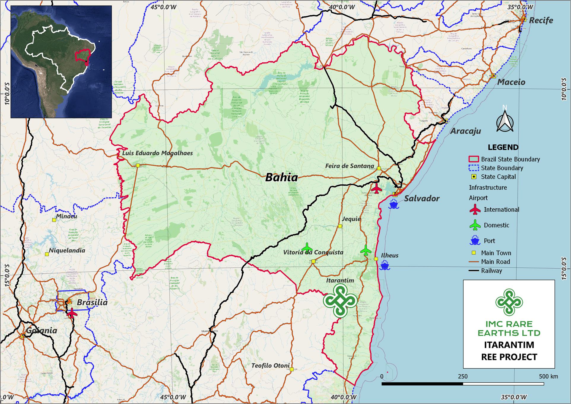
The Project is located in the Bahia State, in northeast Brazil, approximately 10 km west of the town of Itarantim. Access is by sealed roads from the city of Vitoria da Conquista to Itarantim, with travel time of approximately two hours.
IMC has 27 Research Authorization Permits (Research Permit or Permit) held by Niobium Brazil Importacao e Exportacao Ltda (Niobium Brazil), which is 100% owned by IMC, and covers 45,224.09 ha (452 km2). All permits are current with expiry dates between December 2025 and July 2026, and all are renewable for the same period. The Project is centred at approximately 15°41′ S latitude and 40°09′ W longitude (WGS 84).
The resource area is covered by seven permits (Alvara de Pesquisa), held by Niobium Brazil, and are valid until 28 July 2026. They include the permits numbered 871657.2022, 871646.2022, 871659.2022, 871653.2022, 871663.2022, 871667.2022, and 871669.2022. All permits are in good standing, and there are no known impediments to the security of tenure.
| 1.2.1 | Mineral Rights under the Brazilian Mining Code |
A Research Authorization or Research Permit (Alvará de Pesquisa) is issued by the Agência Nacional de Mineração (ANM) for an initial three-year period. The maximum area for the permit is 2,000 hectares. It is renewable for a further three-year period without any relinquishment of land area.
| Page 1 |
| ITARANTIM REE PROJECT, BRAZIL, TECHNICAL REPORT SUMMARY | R257,2025 |
Permissible work which can be undertaken on the Research Permits includes geological surveys and mapping, geophysical and geochemical surveys, drilling, opening of visitable excavations and carrying out surveys of the mineral body, tests on the processing of mineralized materials or useful mineral substances, to obtain concentrates in accordance with market specifications or for industrial use (Article 14). The holder of a Research Permit may carry out the respective works, and necessary auxiliary works and services, on land in the public or private domain, covered by the areas to be researched, provided that he pays the respective owners or occupants compensation for damages and losses that may be caused by the research work (Article 27).
The Research Permit holder pays the annual fee per hectare (TAH) on the last working day of July, if the permit was published in the first half of the year, and on the last working day of January, if the permit was published in the second half of the previous year (Article 20).
The Research Permit may be assigned or transferred, provided that the assignee meets the required legal requirements (Article 22).
Once the final research report has been approved at the end of the Research Permit tenure, the holder will have one year to request a mining concession and, within this period, may negotiate their mining rights (Article 28). The ANM may extend the term for the same period by means of a justified request from the holder.
Article 11 outlines the landowner’s right to participate in the results of mining through a negotiated royalty with the Permit holder. This shall be up to fifty percent of the total amount due to the States, Federal District, Municipalities and bodies of the direct administration of the Union, as financial compensation for the exploration of mineral resources, as provided for in the caput of art. 6º of Law nº 7.990, of 12/29/89 and in art. 2º of Law nº 8.001, of 03/13/90.
All mining permits in Brazil are subject to state and landowner royalties, pursuant to article 20, § 1, of the Constitution and article 11, “b”, of the Mining Code. In Brazil, mining royalties are formally known as Financial Compensation for the Exploration of Mineral Resources (CFEM). It is monetary compensation, based on gross revenues and less allowable deductions, that companies exploiting mineral resources pay to the Federal government for the use of a nationally owned resource. CFEM rates vary from 1% to 3.5%, depending on the substance. CFEM rates for mining rare earth elements are 2%. The landowners’ royalties may be subject to negotiation; however, if there’s no agreement to access the land or the contract does not specify the royalties, Article 11, §1, of the Mining Code stipulates that the royalties will correspond to half of the amounts paid as CFEM.
CFEM was established by the 1988 Federal Constitution (Article 20, §1) and regulated by the Mining Code (Decree-Law No. 227/1967) and Law No. 13,540/2017, which contains more detailed current rules.
| 1.3 | Accessibility, Climate and Physiography |
The Project area is topographically rugged with a 4–30 m thick regolith developed upon granitic rocks. The highest point on the Project is 1,100 metres above sea level in the northeast region and lowest point is 160 metres above sea level in the southeast region. The regolith comprises clay-rich lateritized regolith and quartz and mica-rich saprolite soils. The area is in an active state of erosion with common slump features as well as incised drainages. The highest and lowest topographic points are characterized by outcropping granite.
The Project area receives rainfall all through the year but increasingly towards the January to March period. The wet season runs from about late-October to mid-April, and the dry season is approximately mid-April to late-October.
| Page 2 |
| ITARANTIM REE PROJECT, BRAZIL, TECHNICAL REPORT SUMMARY | R257,2025 |
The hottest period is from late-November through early-April, ranging from an average high of 32°C (89°F) to a low of 21°C (69°F). The coolest period is from the end of May to late-August, ranging from an average high of 26°C (79°F) to a low of 16–17°C (61°F). Exploration activities can be carried out year round, with some reduced access to parts of the Project during the wet season.
Access is by sealed roads from the city of Vitoria da Conquista to Itarantim approximately two hours away. The town of Itarantim is reasonably developed with food, fuel and restaurant services. All roads linking the town to the north and south are good quality tarmac. The Project can be accessed from Itarantim by unsealed roads (gravel or dirt), which can become difficult to negotiate after rain.
Cattle ranching is the primary industry in the Project area. Little primary vegetation exists, with most land converted to grassland and oil palms.
The regional infrastructure and services are well developed, and the area is 110 km from the nearest airport (Vitoria da Conquista) and 350 km from the Port of Salvador. Porto Sul, a deepwater sea terminal located 150 km northeast of the Project at Ilheus, is scheduled to become operational in 2027. Electricity supply is available to the Project via the State electrical grid and water supply is readily available via local sources including local storage facilities and water bores. There is a reliable labor source locally in Itarantim and adjacent locales. Bahia State is located adjacent to the State of Minas Gerais, an established mining jurisdiction in Brazil, and therefore experienced mining personnel should be easily sourced for future mining activities from this region.
| 1.4 | History |
No historical exploration activities for any mineral commodity are known to have occurred on the Project prior to IMC acquiring the research permits over the Project area. Limited drilling for water for local farms is believed to have occurred, and a number of small-scale quarries are located south of the Project area.
There has been no prior mining production in the Project area. There have been no previous Mineral Reserves disclosed for the Project.
| 1.5 | Geology and Mineralization |
| 1.5.1 | Regional and Local Geology |
At a regional geological scale, the Project area is underlain by high-grade orthogneisses of the Neoarchean Sao Franciscan terrane, as well as a large multi-phase alkaline intrusion known as the Itarantim Complex, and forms part of the Neoproterozoic Itabuna Intrusive Suite.
At a local geological scale, the rocks comprising the Itarantim Complex consist of a number of phases including alkaline granites, syenites, nepheline syenites, and possible fenite zones. The area is underlain by various deformed alkaline granites belonging to the Itarantim alkaline granite complex.
| 1.5.2 | Mineralization and Deposit Style |
REE mineralization occurs in economic quantities in a number of rock types, namely carbonatites, alkaline granites and related silica undersaturated rocks, as well as certain pegmatites.
The majority of REE minerals in granites are either represented by allanite or monazite, with monazite being particularly important as a source of REEs. REEs may also be hosted in the carbonate mineral bastnaesite. Additionally, REEs may be sequestered onto the surface of certain clay minerals such as kaolinite and this style of REE mineralization allows for the use of in-situ recovery methods to extract the REEs.
| Page 3 |
| ITARANTIM REE PROJECT, BRAZIL, TECHNICAL REPORT SUMMARY | R257,2025 |
The majority of REEs in the alkaline granites of the Project are assumed to be included within the mineral monazite. Monazite is resistant to prolonged weathering and erosion and may be concentrated through eluvial enrichment. During chemical weathering, the monazite breaks down and releases REE ions into solution.
The Itarantim REE Project is an ionic adsorption clay (IAC) REE deposit hosted in clays within a regolith above an alkali granite. The REE mineralization is adsorbed onto clay minerals, typically kaolinite and halloysite. In regolith grading between 500 ppm and 3,000 ppm REE, 60–90% of the REE mineralization is adsorbed onto these clay minerals. The REEs are recoverable using simple inorganic salt solutions in a leaching process, with the REEs readily transferred into solutions such as sulfates or chlorides, depending on whether the lixiviant (the salt solution) is sodium chloride (NaCl) or ammonium sulfate ((NH4)2SO4).
The IAC-style of REE deposit at Itarantim is hosted in the regolith (weathered rock) profile formed above an alkaline granite. The regolith profile is extensive in area, and IMC has only investigated a portion of the regolith present in their tenure so far. The potential area of REE mineralization is therefore also potentially widespread in lateral extent. Note, however, that the extent of the regolith profile is sometimes curtailed by shallow subcropping and outcropping granite, and the regolith can have a shallow depth in the valley floors.
| 1.6 | Status of Exploration and Drilling |
There has been no previous exploration on the Project prior to IMC’s activities.
Airborne radiometric geophysical were completed by CPRM (Companhia de Pesquisa de Recursos Minerais – now Serviço Geológico do Brasil) to map prospective geology and identify thorium anomalies potentially associated with elevated REEs in the regolith. Detailed soil geochemistry was completed to assist in the initial drillhole targeting. Trenching, with channel sampling, was completed to verify drill results.
Auger drilling commenced on the Project in 2023. As at June 2025, 532 holes totaling 7,080 m have been completed. Drilling is ongoing at the effective date of the TRS. Typically, a drillhole is terminated when it can no longer penetrate through saprock, on rare occasions reaching bedrock. Samples are extracted from the coring tube at 0.2 m intervals to obtain 1.0 m composite sample with a mass of approximately 10–12 kg. Geological logging is carried out at the drill rig and photographs of the chip trays are done at the sample process facility.
A LiDAR (light detection and ranging) survey was flown in August 2024 and used to generate a three-dimensional (3D) topographic surface at a 0.1 m resolution. Drill collar locations are picked up by the global positioning system (GPS) and registered with the LiDAR surface. Downhole surveys are not required, as all holes are vertical and relatively shallow.
Drillhole spacing is approximately 320 m both along drill lines and between lines. A tighter grid of holes was drilled in 2025, spaced at approximately 90 m (X) by 80 m (Y), with drillhole IDs of AD-00470 to AD-00488.
IMC recently engaged the services of WSP Brasil Consultoria e Projetos Ltda (WSP) to provide hydrogeological services. The work has only recently started and is currently in progress. WSP has completed the compilation and analysis of existing geological and hydrogeological data in the area, and plans are underway for drilling and installation of a network of groundwater monitoring wells in and around the area, with the objective of advancing the understanding of the hydrogeological conditions at the Project.
No geotechnical work or studies have been conducted on the Project.
| Page 4 |
| ITARANTIM REE PROJECT, BRAZIL, TECHNICAL REPORT SUMMARY | R257,2025 |
| 1.7 | Sampling, Analyses and Security |
The Itarantim sample preparation facility is a locked secure compound which is used to receive, prepare and store samples, and undertake other geological related tasks such as chip photography and data entry. Samples are weighed, screen quarter sampled twice to generate a primary sample for assay and a field duplicate. Samples are weighed again, ticketed and dispatched to the laboratory for assay. Samples are transported to ALS once a week by IMC contract employees, where the samples then come under the ALS security protocols upon delivery.
Early samples (2023) were sent to SGS Belo Horizonte. Due to poor turnaround time, samples from AD-00141 onwards were sent to ALS Global Belo Horizonte. SGS samples were dried, crushed, pulverized and subsampled to 250 g, then analyzed using lithium metaborate fusion determination (ICP-MS). ALS samples were split, pulverized, and subsampled to 250 g, then analyzed for a whole rock package analysis ICP–atomic emission spectroscopy (AES), and lithium borate fusion (ICP-MS) methodology. A subset of samples were submitted to ALS for leaching tests using a weak acidified ammonium sulfate as the lixiviant.
IMC includes regular, industry-compliant quality assurance/quality control (QAQC) processes as part of the sampling procedure, incorporating certified reference material (CRM) standards, blanks, field duplicates, laboratory replicate assaying (pulps), and umpire analyses into the sampling stream. The ratio of sample insertion is 5% CRM, 5% duplicates, and 5% blanks. CRMs were sourced from ORE Research & Exploration Pty Ltd (OREAS) and are certified for rare earths. Quality control results are monitored by the database management consultancy Earth SQL, reporting any potential errors in the analytical process or deviations from the required processes.
| 1.8 | Data Verification |
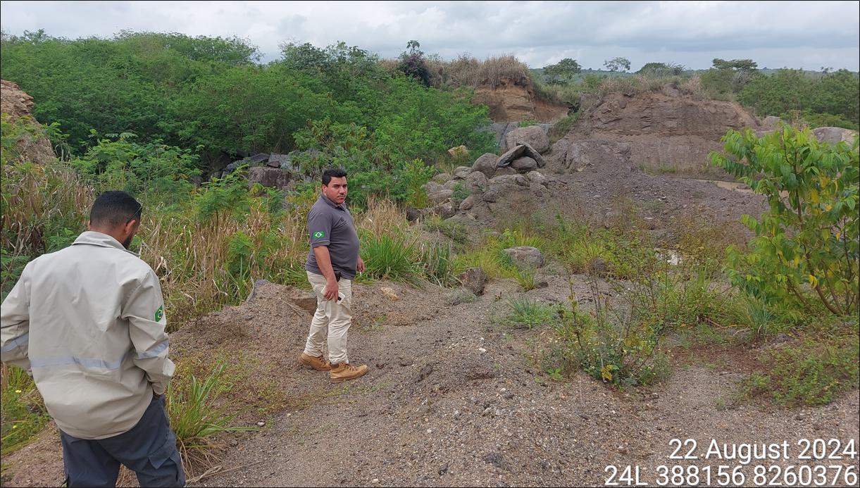
A site visit (personal inspection) was undertaken by an employee of ERM between August 20 and 22, 2024 and all key aspects of the Project including drill locations, data collection procedures, verification of a selection of drill samples, and all key aspects that inform the Mineral Resource estimate (MRE) were inspected. No issues were identified during his personal inspection.
ERM also independently verified the exploration, sampling, and analytical data supporting the Itarantim MRE through review of field records, laboratory certificates, and database validation checks. Collar positions and assay data were confirmed for accuracy and completeness, and QAQC results from CRMs, blanks and duplicates were found to be within acceptable industry limits. No material errors or inconsistencies were identified. ERM concludes that the data are accurate, reliable, and suitable for use in mineral resource estimation in accordance with the requirements under S-K 1300.
ERM is fully independent of the Registrant (IMC).
| 1.9 | Mineral Processing and Metallurgical Testing |
Several phases of metallurgical testwork have been carried out during the Project investigation. These phases can be broken down by: (i) early verification; (ii) progress monitoring and selective sampling; and (iii) channel sampling. The total amount of leach testwork completed on the Project includes 142 auger holes and 3 channel samples for a combined total of 1,917 samples spanning the resource area.
The early verification testwork was done to determine the nature of the REE mineralization and if it was amenable to leaching by standard lixiviants. A total of 114 samples from 9 auger holes (AD-00001 to AD-00009) were submitted for elution leach testing at the laboratory of the CDTN in Belo Horizonte.
| Page 5 |
| ITARANTIM REE PROJECT, BRAZIL, TECHNICAL REPORT SUMMARY | R257,2025 |
A composite of the results obtaining TREE-Ce >40% leach demonstrated a mean leach percentage of 60%, with a minimum leach percentage of 45% and maximum leach percentage of 74%. These results demonstrate that the REE mineralization encountered in the drilling may be classified as ionically adsorbed, and the mineral system classified as an ionic adsorption deposit, with the leach percentage achieved in line with current producers such as Longnan in China (Li et al., 2017).
A further 21 duplicate samples were sent to the University of Brighton (UK) for additional testing and verification, including x-ray diffraction (XRD) and near infrared spectroscopy (NIR) for clay mineral identification.
The results of this work were positive, with the shallow parts of the regolith largely composed of kaolinite and/or halloysite, being the most important clay minerals which host adsorbed REEs.
All further leaching work was undertaken by ALS Global utilizing their ME-MS19 ammonium sulfate leach and analysis package.
| 1.10 | Mineral Resource Estimate |
| 1.10.1 | Data Inputs, Domain Modeling, and Compositing |
Drill data is the key data input informing the grade estimation of the MRE. The drill database was verified for errors such as:
| ● | Missing data | |
| ● | Multiple entries | |
| ● | Overlapping intervals | |
| ● | Incorrect intervals. |
The elemental assay fields were converted to oxides using an appropriate stoichiometric equation. IMC used the drillhole files for geological modeling and as a basis for grade interpolation.
Univariate statistical analysis was carried out on the assay data to determine an appropriate cut-off for modeling the mineralization (TREO) envelope, which was determined to be 630 ppm TREO (total rare earth oxides).
Five lithological domains were defined from whole rock elemental analysis along with the TREO geochemical profiles. These were subsequently combined into three domains due to the large drillhole spacing not supporting detailed sub-domaining at this stage. The boundaries used for modeling were simplified into Hanging Wall (Depleted Zone), Min 630 (630 cut + Upper Transition Zone + Lower Transition Zone) and Footwall (Fresh).
TREO 3 m composites were generated and then used to generate a 630 ppm footwall surface. The hanging wall surface was defined by either the topography, if mineralization persisted to the top of hole, or to the top of 630 ppm cut interval if the mineralization is intersected lower than the top of the hole. Both surfaces were combined to make a solid representing the >630 ppm TREO mineralized domain. No weathering surfaces were modeled due to the lack of detailed information between the large space drilling.
| 1.10.2 | Statistics, Geostatistics and Density |
Statistical analysis of the composite data was carried out for all rare earth oxides, including histogram and probability plots. Grade capping analysis was carried out and applied where deemed necessary. Variography was completed determining kriging parameters and to guide the choice of grade estimation search radii. Data were adjusted to normal scores prior to variography
to assist with modeling the moderate to high positive skew sometimes displayed by the variables. Variograms were generated from 1 m top cut composited data.
| Page 6 |
| ITARANTIM REE PROJECT, BRAZIL, TECHNICAL REPORT SUMMARY | R257,2025 |
Density data was collected from 59 samples collected from 10 sites in Blocks A and C and tested using the Standard Penetration Test (SPT) method. Samples were then sent to ALS for density determination using method GRA09as. A density value of 1.8 t/m3 was assigned to all blocks in the resource model.
| 1.10.3 | Block Model Parameters, Estimation Methodology and Validation |
A parent block size of 100 m(X) by 100 m(Y) by 4 m(RL) was set up with sub-blocking down to 10 m(X) by 10 m(Y) by 2 m(RL) to honor the relatively flat geometry of the mineralized domain. Parent block sizes were approximately half to one-third of the typical drill spacing.
Top cut composited samples were used to interpolate the grade variables into the block model using ordinary kriging. Grade estimation was constrained by the >630 ppm mineralization domain and was a hard boundary. A search ellipse of 1,000 m(X) by 1,000 m(Y) by 600 m(Z) was used to select samples for grade interpolation, with a minimum of 8 and a maximum of 16 samples used per block estimate. A maximum of 4 samples per drillhole were permitted for each block estimate. Grades were interpolated into the parent cell and the grades assigned to all sub-cells.
Validation of the block model and grade estimates was completed by: visual checks of the drill composite grades vs the block model estimates; statistical comparison of sample and block grades; swath plot analysis to compare input and output grades by easting, northing and elevation; and check for negative or absent block grades. Validation results showed the mean block grades compared favorably with the mean sample grades. Swath plots showed some smoothing of the interpolated block grades compared to the input sample data, which is to be expected by ordinary kriging methodology, however, the sample data trends can still be observed in the block grade distribution.
| 1.11 | Mineral Resource Reporting |
| 1.11.1 | Initial Assessment and Reasonable Prospects for Economic Extraction |
ERM has completed an Initial Assessment and believes there are reasonable prospects for economic extraction (RPEE) of the Mineral Resource due to the deposit demonstrating sufficient grade, quantity and continuity to support RPEE. Additionally, the deposit is supported by nearby infrastructure including: close proximity to large population centers; located within 150 km of a planned maritime port facility at Ilheus and 350 km from the port at Salvador; close to power and water infrastructure; and access to a local workforce to support future operations.
The leachability of the rare earth mineralization from the clay host minerals is favorable for extraction by either in-situ leaching or open pit mining, followed by heap leaching or alternative extraction methods. Leachability and recovery work, completed by IMC, supports this.
A cut-off 650 ppm TREO has been determined to be appropriate for reporting the Inferred MRE and meeting RPEE. The cut-off basis reflects an Initial Assessment using: individual REE metal prices; REE oxide recoveries; proportions of the individual REE oxides as a percentage of the total rare earths; and reasonable economic assumptions, based on an assumed open pit mining method.
The cut-off grade has been derived as the optimal grade where revenue from processing one tonne of already-mined material equals the processing cost. A marginal (processing-based) cut-off grade was determined using a revenue-to-cost methodology because it reflects a strategy focused on optimizing processing activities within a laterally continuous, near-surface ionic clay mineralized system.
The QP considered the lower confidence level for the estimated rare earth grades for an Inferred MRE and then also considered a range of grades within a reasonable tolerance limit to determine the marginal cut-off grade. The calculated value was then compared with the grade tonnage table and a value of 650 ppm TREO was determined to be reasonable for reporting the MRE.
| 1.11.2 | Mineral Resource Estimate Classification |
The MRE has been prepared and reported in accordance with Item 1300 of Regulation S-K (Subpart 229.1300) under the United States Securities and Exchange Commission (SEC). The Mineral Resource category of Inferred Mineral Resource used in this Report follows the definitions set out in §229.1300 Definitions. The estimation methodology and classification criteria have been reviewed by ERM and are consistent with the requirements of S-K 1300, including the criteria set forth in §229.1302(d)(1). The MRE classification is based upon an assessment of geological understanding of the deposit, geological and grade continuity, drillhole spacing, quality control results, search and interpolation parameters, and an analysis of available density information. The Inferred Mineral Resource has not been significantly extrapolated beyond the limits of the drillholes.
| 1.11.3 | Mineral Resource Statement |
The MRE is classified as an Inferred Mineral Resource and is presented in Table 1-1 and is reported above a cut-off grade of 650 ppm TREO. The MRE has an effective date of March 31, 2025. The MRE includes reporting of “heavy rare earth oxides” (HREO), “light rare earth oxides” (LREO), “magnet rare earth oxides” (MREO), “heavy MREO” (DyTb), “light MREO” (NdPr), individual magnet rare earth oxides (Tb4O7,DY2O3, PR6O11, ND2O3, and deleterious oxides U3O8 and ThO2. The MRE is reported by block region, as discussed in Section 7.1.2.
The MRE is reported on an in-situ basis, representing the estimated tonnes and grades (ppm TREO) in the ground and prior to the application of any modifying factors. The resource is constrained a by mineralised envelope defined at a statistical threshold of approximately 630 ppm TREO, which distinguishes mineralised material from surrounding lower-grade zones.
No adjustments have been made to the reported Mineral Resource for mining recovery, dilution, metallurgical recovery, payability, or other economic modifying factors. These factors have been considered separately to support reasonable prospects for eventual economic extraction, including the derivation of the cut-off grade, but have not been applied to the reported resource.
| Page 7 |
| ITARANTIM REE PROJECT, BRAZIL, TECHNICAL REPORT SUMMARY | R257,2025 |
| Table 1-1 | Itarantim Inferred Mineral Resource with cut-off grade of TREO >650 ppm - effective March 31, 2025 |
| Mineral Resource Estimate | Block | Tonnes (Mt) |
TREO (ppm) |
Contained
TREO (Mt) |
LREO (ppm) |
HREO (ppm) |
MREO (ppm) |
Ratio MREO:TREO | NdPr (ppm) |
DyTb (ppm) |
Tb4O7 (ppm) |
Dy2O3 (ppm) |
Pr6O11 (ppm) |
Nd2O3 (ppm) |
U3O8 (ppm) |
ThO2 (ppm) |
| Inferred | A | 190 | 1,148 | 0.223 | 951 | 198 | 239 | 0.21 | 214 | 25 | 4 | 21 | 47 | 168 | 6 | 24 |
| B | 120 | 1,170 | 0.143 | 941 | 228 | 237 | 0.20 | 209 | 28 | 4 | 24 | 46 | 163 | 8 | 38 | |
| C | 330 | 1,127 | 0.372 | 934 | 193 | 216 | 0.19 | 191 | 24 | 4 | 21 | 42 | 150 | 8 | 33 | |
| D | 410 | 1,390 | 0.574 | 1,175 | 216 | 251 | 0.18 | 224 | 27 | 4 | 23 | 49 | 175 | 10 | 37 | |
| E | 40 | 1,057 | 0.038 | 898 | 159 | 222 | 0.21 | 202 | 21 | 3 | 17 | 43 | 159 | 5 | 18 | |
| Total Inferred Resources | 1,100 | 1,233 | 1.350 | 1,027 | 205 | 236 | 0.19 | 210 | 26 | 4 | 22 | 46 | 164 | 8 | 33 | |
Notes to accompany MRE table:
| ● | Mineral resources are reported using definitions set out in Regulation S-K 1300 and are current as of March 31, 2025. |
| ● | The third-party firm responsible for the MRE is ERM. |
| ● | Mineral resources are reported at a cut-off grade above 650 ppm TREO. Key assumptions used in the MRE and to meet RPEE are indicated in Table 1-1 above. |
| ● | The point of reference for the MRE is in situ. |
| ● | Mineral resources have been rounded and due to effects of rounding, the total may not represent the sum of all components. |
| ● | Mineral Resource is only reported from blocks within the permit areas. |
| ● | LREO = La2O3, CeO2, Pr6O11, Nd2O3, Sm2O3, Eu2O3. |
| ● | HREO = Gd2O3, Tb4O7, Dy2O3, Ho2O3, Er2O3, Tm2O3, Yb2O3, Lu2O3, Y2O3. |
| ● | TREO = LREO + HREO. |
| ● | Contained TREO (MT) = (Tonnes * TREO (converted to percent))/1,000,000 |
| ● | Ratio MREO:TREO = MREO / TREO |
| ● | DyTb = Tb4O7 + Dy2O3, being the sum of the heavy magnetic rare earth oxides |
| ● | NdPr = Pr6O11 + Nd2O3, being the sum of the light magnetic rare earth oxides |
| ● | MREO = DyTb + NdPr. |
| ● | Density of 1.8 t/m3 applied to all blocks in mineralization zone. Density is a wet density. |
| Page 8 |
| ITARANTIM REE PROJECT, BRAZIL, TECHNICAL REPORT SUMMARY | R257,2025 |
| 1.12 | Interpretation and Conclusions |
The Itarantim REE Ionic Adsorption Project represents an early-stage exploration project in the Bahia State located in northeast Brazil. The Project is a new REE discovery and has had moderate to intensive exploration activities (including geophysics, geological mapping, surface geochemistry and auger drilling) conducted by IMC over the past four years.
An Inferred MRE is supported by drilling completed by IMC. The Project contains REE mineralization with 60–90% of the REEs physically adsorbed onto clay minerals, notably kaolinite and halloysite. These REEs can be recovered by using simple inorganic salt solutions whereby during the leaching process the REEs are readily transferred into solution as soluble sulfates or chlorides, depending upon the lixiviant used.
ERM considers that data collection techniques are consistent with current industry best practice and suitable for use in the preparation of a MRE to be reported in accordance with S-K 1300. QAQC sampling and results support the integrity of the data which has been used to prepare the MRE.
A 3D wireframe model representing TREO mineralization (TREO ≥630 ppm) is based upon geological logs and geochemical analyses of drillhole samples. Machine augered drillhole samples were used to interpolate grades into blocks using ordinary kriging. Several methods were used to validate the block model, including visual review and comparison of sampling and block model grades.
The MRE was classified as Inferred Mineral Resources and is reported above a cut-off grade of 650 ppm TREO. Global leachability results support the reporting of an ionic adsorption Mineral Resource.
ERM has completed an Initial Assessment and is of the opinion that the Inferred Mineral Resource classification is appropriate based on the informing data and underlying understanding of the mineralization of the deposit at this stage of the Project. Furthermore, ERM is of the opinion that deposit is of sufficient grade, quantity and coherence to meet RPEE at this stage of the Project development. Further work is required, in particular infill drilling at a closer drill spacing, to enable detailed interpretation of internal stratigraphic domaining of the mineralization to inform mine studies for economic evaluation.
ERM is of the opinion that the exploration potential for the Itarantim Project is high. The combination of favorable regional geological location; highly prospective local geology and potential structural framework; an active geomorphology; favorable and coincident geochemical and geophysical anomalies; and successful drill results to date, confirm the prospectivity of the area for discovery of further REE mineralization.
| 1.13 | Recommendations |
ERM recommends the following actions are completed to support the ongoing Mineral Resource evaluation effort at Itarantim:
| ● | Further geological mapping is recommended to support the geological understanding of the Project, focusing on zones with elevated MREO grades and other key target areas. | |
| ● | Petrographic studies focused on REE mineral deportment and host clay mineralogy, by scanning electron microscope (SEM) or NIR. | |
| ● | Undertake an alternative drilling method (diamond, sonic) that can penetrate below the base of mineralization, and/or into the primary rock. | |
| ● | Twin several auger holes with the new drilling method for QAQC purposes. |
| Page 9 |
| ITARANTIM REE PROJECT, BRAZIL, TECHNICAL REPORT SUMMARY | R257,2025 |
| ● | Infill drilling at closer spacing is required to allow for geological interpretation of high-grade leachability resource zones. | |
| ● | Undertake a substantial program of density testwork. The samples should be oven dried prior to density calculations to ensure future density determinations are regarded as ‘dry density’. | |
| ● | Continue with the current QAQC efforts, with regular monitoring of results and action on any failed results. | |
| ● | IMC technical staff and/or ERM should conduct a laboratory visit at least once per year. | |
| ● | Incorporate full umpire testing for sample assays, initially targeting the MREO zones. | |
| ● | Planned geometallurgy studies should include both geological and metallurgical data reviews. |
IMC should continue their efforts to fulfill obligations regarding environmental, social and governance (ESG), including studies such as baseline environmental surveys, early-stage hydrogeological assessments, community engagement workshops, and other related activities for future reporting requirements.
IMC provided ERM with a projection of its planned exploration expenditures for the Project for an initial two-year period post listing on the NYSE American.
ERM has reviewed this expenditure in the context of the work activities recommended for the Project and considers the proposed budgets are consistent with the exploration potential of the Project, are adequate to cover the costs of the proposed programs, and are appropriate for the type and weighting of activities at the Project.
Table 1-2 provides a detailed breakdown of exploration expenditure over the first two years based on meeting the recommended work activities required to continue advancing the Project.
| Table 1-2 | Planned expenditure for recommended exploration activities during first two years |
| Proposed expenditure | Year 1 (USD million) | Year 2 (USD million) | Total (USD million) |
| Geological/Geophysical survey | 0.8 | 0.7 | 1.6 |
| Regional geochemistry | 0.03 | 0.03 | 1.0 |
| Exploration drilling | 0.1 | 0.1 | 0.2 |
| MREO infill drilling | 0.4 | 0.3 | 0.7 |
| Diamond drilling | 0.1 | 0.1 | 0.2 |
| Hydrological drilling | 0.2 | 0.2 | 0.4 |
| Resource drilling | 0.2 | 0.9 | 1.1 |
| Assaying | 0.3 | 0.3 | 0.7 |
| Technical/Metallurgical studies | 1.5 | 4.2 | 5.7 |
| ESG | 0.1 | 0.2 | 0.3 |
| Total | 3.7 | 7.1 | 10.8 |
| Page 10 |
| ITARANTIM REE PROJECT, BRAZIL, TECHNICAL REPORT SUMMARY | R257,2025 |
| 2. | Introduction |
| 2.1 | registrant and Terms of Reference |
IMC Rare Earths Ltd (the Company, IMC or the Registrant) is completing work to develop a large high-grade magnet rare earth element (REE) Mineral Resource project (the Itarantim REE Project, Itarantim Project or the Project) located in the Bahia State of northeast. This Initial Assessment Technical Report Summary (TRS or Report) was prepared for IMC by the Technical Mining Services Team (TMS) of ERM Australia Consultants Pty Ltd (ERM). The purpose of this Report is to support IMC’s disclosure of Mineral Resource estimate for the Itarantim REE Project, an exploration stage property located in the Bahia State of northeast Brazil, for the fiscal year ended March 31, 2025. No Mineral Reserve estimate is reported in this Report. This TRS has been prepared in accordance with the U.S. Securities and Exchange Commission’s (SEC) Subpart 1300 of Regulation S-K, Disclosure by Registrants Engaged in Mining Operations and Item 601(b)(96) of Regulation S-K, Technical Report Summary.
All currency amounts are in United States dollars (USD) unless otherwise stated.
The interpretations and conclusions reached in this Report are based on current scientific understanding and the best evidence available to the authors at the time of writing. It is the nature of all scientific conclusions that they are founded on an assessment of probabilities and, however high they might be, make no claim for absolute certainty.
The ability of any person to achieve forward-looking production and economic targets depends on numerous factors beyond ERM’s control and that ERM cannot anticipate. These factors include, but are not limited to, site-specific mining, and geological conditions, management, and personnel capabilities, availability of funding to properly operate and capitalize the operation, variations in cost elements, and market conditions, developing and operating the mine efficiently, unforeseen changes in legislation, and new industry developments. Any of these factors may substantially alter the performance of any mining operation.
| 2.2 | Principal Sources of Information |
This Report is based on data and technical reports provided to ERM by IMC, and the data, reports and documents cited herein. ERM has relied on IMC for the information specified in Section 25.
ERM acknowledge the assistance from the following individuals involved in the Project:
| ● | Frank Scolaro – Director and Chairman, IMC | |
| ● | Simon Rollason – Technical Advisor, IMC | |
| ● | Toby Dawborn – Technical Advisor, IMC |
The authors have endeavored to confirm the authenticity and completeness of the technical data upon which the Report is based by making all reasonable enquiries within the time available.
| 2.3 | Qualified Persons |
This Report was prepared by ERM, a third-party consulting firm comprising mining experts in accordance with § 229.1302(b)(1)[1]. IMC has determined that ERM meets the qualifications specified under the definition of QP in § 229.1300. References to the Qualified Person or QP in this report are references to ERM and not to any individual employed at ERM.
IMC is using the allowance for a third-party firm consisting of mining experts (ERM) to date and sign the Report.
| 2.4 | Site Visit and Personal Inspection |
An employee of ERM conducted a site visit (personal inspection) of the Project between August 20 and 22, 2024. During the site visit, ERM was able to confirm the geology and mineralization, and access and local infrastructure of the Project.
1US Securities and Exchange Commission (US SEC) S-K regulations (Title 17, Part 229, Items 601 and 1300 through 1305)
| Page 11 |
| ITARANTIM REE PROJECT, BRAZIL, TECHNICAL REPORT SUMMARY | R257,2025 |
| 3. | Property Description |
| 3.1 | Location of Project |
The Project is located in the Bahia State, in northeast Brazil, approximately 10 km west of the town of Itarantim. Access is by sealed roads from the city of Vitoria da Conquista to Itarantim, with travel time of approximately two hours. A map showing the location of the Project is presented in Figure 3-1. The Project is centered at approximately 15°41′ S latitude and 40°09′ W longitude (WGS 84).
| Figure 3-1 | Location map – Itarantim |
Source: IMC, 2024
| Page 12 |
| ITARANTIM REE PROJECT, BRAZIL, TECHNICAL REPORT SUMMARY | R257,2025 |
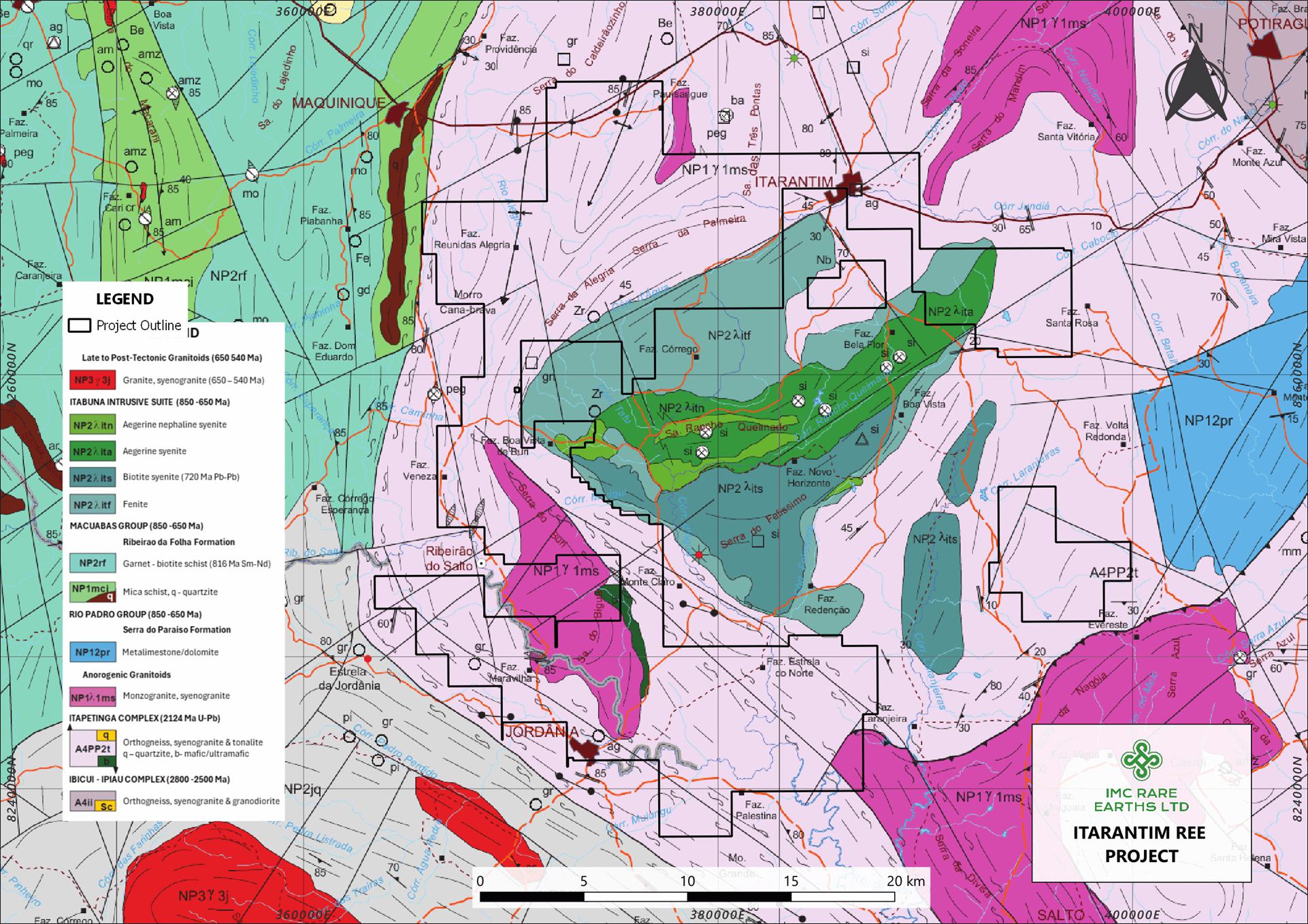
| 3.2 | Exploration Permits, Mineral Rights and Surface Rights |
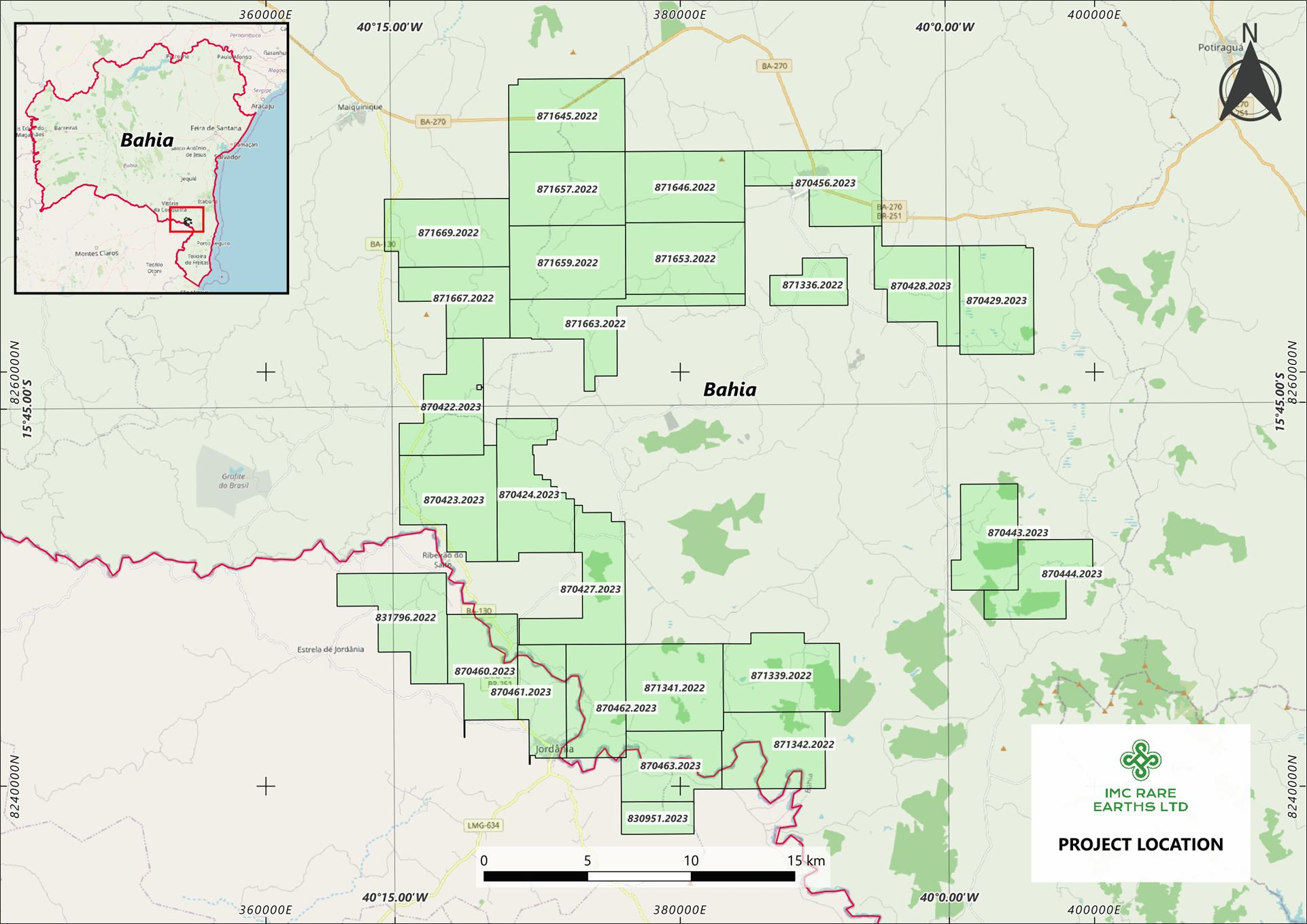
Brazil is regarded as an important and prominent mining jurisdiction globally with stable regulatory and title frameworks. The country has excellent mining infrastructure and services, and strong logistics connections to the USA, Europe and China. IMC has 27 Research Permits held by Niobium Brazil Importacao e Exportacao Ltda (Niobium Brazil), an indirect, wholly owned subsidiary of IMC, and these permits cover an area of 45,224.09 ha (452 km2). All permits are current with expiry dates between December 2025 and July 2026, and all are renewable for the same duration and annual fees as the current permit. All permits are categorized as “Research Permits” in Brazil. For the information regarding the terms, conditions and rights granted by Research Permits in Brazil, refer to a description of mineral rights in Brazil below.
The resource area is covered by seven permits (Alvara de Pesquisa) held by Niobium Brazil and are valid until the 28 July 2026. They include the permits numbered 871657.2022, 871646.2022, 871659.2022, 871653.2022, 871663.2022, 871667.2022, and 871669.2022. All permits are in good standing, and there are no known impediments to the security of tenure.
A research permit map is presented in Figure 3-2 and the research permit schedule is presented in Table 3-1.
| Figure 3-2 | Itarantim Research Permit Areas |
Source: IMC, 2024
| Page 13 |
| ITARANTIM REE PROJECT, BRAZIL, TECHNICAL REPORT SUMMARY | R257,2025 |
| Table 3-1 | Research Permit Schedule (all permits 100% owned by Niobium Brazil) |
| Permit no. | Issued | Expiry | Area (ha) | State | Municipality | Annual fees (US$) |
| 831.796/2022 | 26/08/2022 | 26/12/2025 | 1,850.40 | Minas Gerais | Jordania | 1,515.79 |
| 871.336/2022 | 25/08/2022 | 9/01/2026 | 729.15 | Bahia | Itarantim | 597.30 |
| 871.339/2022 | 25/08/2022 | 9/01/2026 | 1,990.88 | Bahia | Itarantim | 1,630.87 |
| 871.341/2022 | 25/08/2022 | 9/01/2026 | 1,978.39 | Bahia | Itarantim | 1,620.63 |
| 871.342/2022 | 25/08/2022 | 9/01/2026 | 1,843.37 | Bahia | Itarantim | 1,510.03 |
| 871.645/2022 | 7/10/2022 | 9/01/2026 | 1,966.94 | Bahia | Itarantim | 1,611.25 |
| 871.646/2022 | 7/10/2022 | 9/01/2026 | 1,982.49 | Bahia | Itarantim | 1,623.99 |
| 871.653/2022 | 10/10/2022 | 9/01/2026 | 1,993.89 | Bahia | Itarantim | 1,633.33 |
| 871.657/2022 | 10/10/2022 | 9/01/2026 | 1,993.41 | Bahia | Itarantim | 1,632.94 |
| 871.659/2022 | 10/10/2022 | 9/01/2026 | 1,992.00 | Bahia | Itarantim | 1,631.78 |
| 871.663/2022 | 11/10/2022 | 9/01/2026 | 1,659.77 | Bahia | Itarantim | 1,359.63 |
| 871.667/2022 | 11/10/2022 | 9/01/2026 | 1,435.16 | Bahia | Maiquinique | 1,175.64 |
| 871.669/2022 | 11/10/2022 | 9/01/2026 | 1,934.58 | Bahia | Maiquinique | 1,584.75 |
| 870.422/2023 | 30/03/2023 | 11/07/2026 | 1,617.99 | Bahia | Itarantim | 1,325.41 |
| 870.423/2023 | 30/03/2023 | 11/07/2026 | 1,998.26 | Bahia | Itarantim | 1,636.91 |
| 870.424/2023 | 31/03/2023 | 25/07/2026 | 1,949.19 | Bahia | Itarantim | 1,596.71 |
| 870.427/2023 | 31/03/2023 | 11/07/2026 | 1,758.77 | Bahia | Itarantim | 1,440.73 |
| 870.460/2023 | 6/04/2023 | 18/08/2026 | 1,595.08 | Bahia | Itarantim | 1,306.64 |
| 870.461/2023 | 6/04/2023 | 18/08/2026 | 1,178.73 | Bahia | Itarantim | 965.58 |
| 870.462/2023 | 6/04/2023 | 25/07/2026 | 1,576.70 | Bahia | Itarantim | 1,291.58 |
| 870.463/2023 | 6/04/2023 | 25/07/2026 | 1,546.82 | Bahia | Itarantim | 1,267.11 |
| 830.951/2023 | 6/04/2023 | 28/07/2026 | 548.97 | Bahia | Itarantim | 449.70 |
| 870.428/2023 | 31/03/2023 | 11/07/2026 | 1,572.76 | Bahia | Itarantim | 1,288.35 |
| 870.429/2023 | 31/03/2023 | 11/07/2026 | 1,874.43 | Bahia | Itarantim | 1,535.47 |
| 870.443/2023 | 3/04/2023 | 11/07/2026 | 1,481.80 | Bahia | Itarantim | 1,213.84 |
| 870.444/2023 | 3/04/2023 | 11/07/2026 | 1,361.80 | Bahia | Itarantim | 1,115.54 |
| 870.456/2023 | 5/04/2023 | 25/07/2026 | 1,812.36 | Bahia | Itarantim | 1,484.63 |
| 3.2.1 | Mineral Rights under the Brazilian Mining Code |
A Research Authorization or Research Permit (Alvará de Pesquisa) is issued by the Agência Nacional de Mineração (ANM) for an initial three-year period. The maximum area for the permit is 2,000 hectares. It is renewable for a further three-year period without any relinquishment of land area.
Permissible work which can be undertaken on the Research Permits includes geological surveys and mapping, geophysical and geochemical surveys, drilling, opening of visitable excavations and carrying out surveys of the mineral body, tests on the processing of mineralized materials or useful mineral substances, to obtain concentrates in accordance with market specifications or for industrial use (Article 14). The holder of a Research Permit may carry out the respective works, and necessary auxiliary works and services, on land in the public or private domain, covered by the areas to be researched, provided that he pays the respective owners or occupants compensation for damages and losses that may be caused by the research work (Article 27).
The Research Permit holder pays the annual fee per hectare (TAH) on the last working day of July, if the permit was published in the first half of the year, and on the last working day of January, if the permit was published in the second half of the previous year (Article 20).
The Research Permit may be assigned or transferred, provided that the assignee meets the required legal requirements (Article 22).
| Page 14 |
| ITARANTIM REE PROJECT, BRAZIL, TECHNICAL REPORT SUMMARY | R257,2025 |
Once the final research report has been approved at the end of the Research Permit tenure, the holder will have one year to request a mining concession and, within this period, may negotiate their mining rights (Article 28). The ANM may extend the term for the same period by means of a justified request from the holder.
Article 11 outlines the landowner’s right to participate in the results of mining through a negotiated royalty with the Permit holder. This shall be up to fifty percent of the total amount due to the States, Federal District, Municipalities and bodies of the direct administration of the Union, as financial compensation for the exploration of mineral resources, as provided for in the caput of art. 6º of Law nº 7.990, of 12/29/89 and in art. 2º of Law nº 8.001, of 03/13/90.
All mining permits in Brazil are subject to state and landowner royalties, pursuant to article 20, § 1, of the Constitution and article 11, “b”, of the Mining Code. In Brazil, mining royalties are formally known as Financial Compensation for the Exploration of Mineral Resources (CFEM). It is a monetary compensation, based on gross revenues and less allowable deductions, that companies exploiting mineral resources pay to the Federal government for the use of a nationally owned resource. CFEM rates vary from 1% to 3.5%, depending on the substance. CFEM rates for mining rare earth elements are 2%. The landowners’ royalties may be subject to negotiation; however, if there’s no agreement to access the land or the contract does not specify the royalties, Article 11, §1, of the Mining Code stipulates that the royalties will correspond to half of the amounts paid as CFEM.
CFEM was established by the 1988 Federal Constitution (Article 20, §1) and regulated by the Mining Code (Decree-Law No. 227/1967) and Law No. 13,540/2017, which contains more detailed current rules.
| 3.3 | Royalties |
All mining permits in Brazil are subject to state and landowner royalties, pursuant to Article 20, §1, of the Constitution and Article 11, “b”, of the Mining Code. In Brazil, mining royalties are formally known as Financial Compensation for the Exploration of Mineral Resources (CFEM). It is monetary compensation, based on gross revenues and less allowable deductions, that companies exploiting mineral resources pay to the Federal Government for the use of a nationally owned resource. CFEM rates vary from 1.0% to 3.5%, depending on the substance. CFEM rates for mining REEs are 2.0%.
The landowners’ royalties may be subject to negotiation; however, if there’s no agreement to access the land or the contract does not specify the royalties, Article 11, §1, of the Mining Code stipulates that the royalties will correspond to half of the amounts paid as CFEM.
CFEM was established by the 1988 Federal Constitution (Article 20, §1) and regulated by the Mining Code (Decree-Law No. 227/1967) and Law No. 13,540/2017, which contains more detailed current rules.
| 3.4 | Environmental Liabilities |
ERM is not aware of any environmental liabilities on the Project.
| 3.5 | Significant Encumbrances to the Property |
There are no significant encumbrances to the Project, and the research permits remain in good standing as of the effective
date of this TRS.
| 3.6 | Other Significant Factors and Risks |
There are no significant factors or risks that may affect access, title, or the right or ability to perform work on the Project.
| Page 15 |
| ITARANTIM REE PROJECT, BRAZIL, TECHNICAL REPORT SUMMARY | R257,2025 |
| 4. | Accessibility, Climate, Local Resources, Infrastructure and Physiography | |
| 4.1 | Topography and Physiography |
The Project area is topographically rugged with a 4–30 m thick regolith developed upon granitic rocks. The highest point on the Project is 1,100 metres above sea level in the northeast region and lowest point is 160 metres above sea level in the southeast region. This is expressed as vivid red, clay-rich lateritized regolith, as well as light brown, quartz and mica-rich saprolite soils. The area is in an active state of erosion with common slump features as well as incised drainages noted. The highest and lowest topographic points are characterized by outcropping granite. An example of the physiography is presented in Figure 4-1.
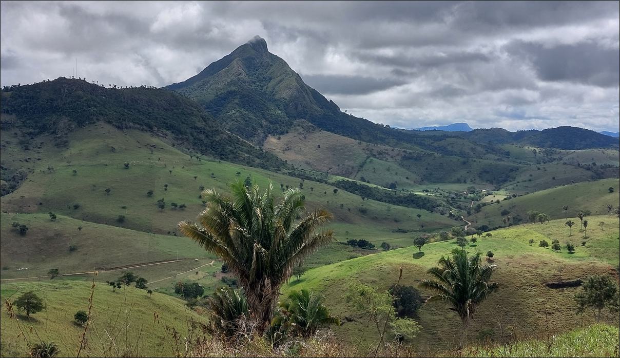
| Figure 4-1 | Photograph of part of the Project area, showing rugged regolith relief with granite “sugarloaf” mountain in background |
| 4.2 | Climate |
The Project area receives rainfall all through the year but increasingly towards the January to March period. The wet season runs from about late-October to mid-April, during which there is a greater than 28% chance of rain on any given day. The dry season is approximately mid-April to late-October. The month with the rainiest days is November averaging ~12.2 days with at least ~0.04 inches of rain. The month with the fewest rainy days is August with ~4.4 days of that minimal precipitation threshold.
The hottest period is from late-November through early-April. In February, the average high reaches about 32°C (89°F) and the average low around 21°C (69°F). The coolest period is from about end of May to late-August. For example, in July the typical high is about 26°C (79°F) and low is about 16–17°C (61°F). Figure 4-2 presents a climate profile for Itarantim.
Exploration activities can be carried out year round, with some reduced access to parts of the Project during the wet season.
| Page 16 |
| ITARANTIM REE PROJECT, BRAZIL, TECHNICAL REPORT SUMMARY | R257,2025 |
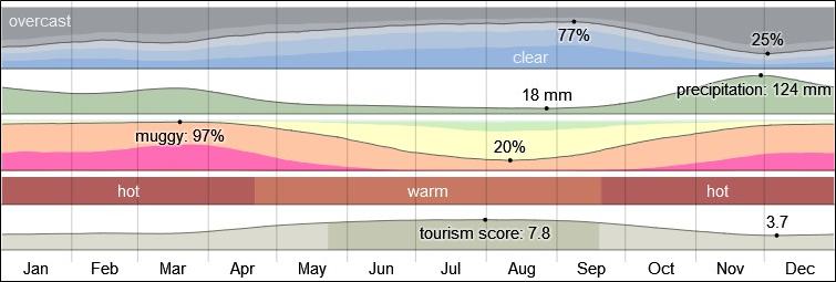
| Figure 4-2 | Climate profile for Itarantim |
Source: Weatherspark.com
| 4.3 | Accessibility, Vegetation, and Local Industry |
Access is by sealed (paved) roads from the city of Vitoria da Conquista to Itarantim, with travel time of approximately two hours. The town of Itarantim has service provision including food, fuel and restaurants while all roads linking the town to the north and south are good quality paved roads. Accommodation in Itarantim is currently considered to be of low quality, therefore Vitoria da Conquista is the preferred location for overnight stays. The Project can be accessed from Itarantim by unsealed roads (gravel or dirt roads). The roads become difficult to negotiate after rain.
Cattle ranching is the primary industry in the Project area. Little primary vegetation growth is noted, with most parts converted to grassland and oil palms. Good relations are evident between the various landowners and IMC’s exploration team.
| 4.4 | Local Resources and Infrastructure |
The regional infrastructure and services are well developed, and the area is 110 km from the nearest airport (Vitoria da Conquista) and 350 km from the Port of Salvador. Porto Sul, a deepwater sea terminal located 150 km northeast of the Project at Ilheus, is scheduled to become operational in 2027.
Electricity supply is available to the Project via the State electrical grid. Water supply is readily available to the Project via local sources including local storage facilities and water bores. There is a reliable labor source locally in Itarantim and other nearby villages as well as from further afield. IMC currently employs many local residents to work on the Project for exploration activities. Bahia State is located adjacent to the State of Minas Gerais, an established mining jurisdiction in Brazil, and therefore experienced mining personnel should be easily sourced for future mining activities from this region. Exploration and drilling supplies, and drilling and geological contractors and labourers are readily available in Bahia State and the region fully supports the Project.
| Page 17 |
| ITARANTIM REE PROJECT, BRAZIL, TECHNICAL REPORT SUMMARY | R257,2025 |
| 5. | History |
| 5.1 | Project and Exploration History |
No prior historical exploration activities for any mineral commodity are known to have occurred on the Project prior to IMC’s involvement. Some drilling for water resources is believed to have occurred, for provision of water for local farms, but details are unknown.
A number of small-scale quarries are located south of the Project area and appear to be developed upon nepheline syenite outcrops. Figure 5-1 presents a photograph of a now disused syenite quarry located 20 km to the south of the Project area.
| Figure 5-1 | Syenite quarry, approximately 20 km south of the Project |
| 5.2 | Historical Production |
There has been no prior mining production in the Itarantim Project area.
| Page 18 |
| ITARANTIM REE PROJECT, BRAZIL, TECHNICAL REPORT SUMMARY | R257,2025 |
| 6. | Geological Setting, Mineralization and Deposit |
| 6.1 | Regional and Local Geology |
| 6.1.1 | Regional Geology |
The Project region is underlain by high-grade orthogneisses of the Neoarchean Sao Franciscan terrane, as well as a large, intrusive alkaline granite known as the Itarantim Complex. This granite and aegirine nepheline syenite complex (Rosa et al., 2005) is poorly exposed and forms part of the Neoproterozoic Itabuna Intrusive Suite. A similar intrusion (Palmares Complex), with reported sodalite and of similar age, is located to the northeast of the Itarantim Complex. It is not well understood, but where outcrops can be seen, such outcrops are largely represented by a hornblende and biotite bearing alkaline granite with a pronounced fabric noted. It has a Pb/Pb zircon age from a biotite syenite of about 721 ± 3 Ma (Conceição Rosa et al., 2005).
| 6.1.2 | Local Geology |
The rocks comprising the Itarantim Complex have been mapped and consist of a number of phases including alkaline granites, syenites, nepheline syenites and possible fenite zones. These rocks are exposed in some valley edges, and along the central parts where they have been mined for syenite in the past, while the prominent ridge which forms the Serra da Alegria and Serra da Palmares run through the Project area.
| 6.2 | Property Geology |
The Project area is underlain by various deformed alkaline granites belonging to the Itarantim alkaline granite complex which has been mapped in some detail, although further mapping is recommended to support the geological understanding of the Project. Large areas are erroneously mapped as “fenite”; fenite is related to alkali metasomatism forced by the intrusion of carbonatite complexes, which are not known in the district. A geological map of the Project area is presented in Figure 6-1.
| Page 19 |
| ITARANTIM REE PROJECT, BRAZIL, TECHNICAL REPORT SUMMARY | R257,2025 |
| Figure 6-1 | Geological map of the Itarantim Complex |
Source: IMC, 2024
At this stage, the source of the identified REE mineralization is unknown but the geochemical data suggests that it is most likely hosted in monazite.
| 6.3 | Deposit Type |
Rare earth element (REE) mineralization occurs in economic quantities in a number of rock types, namely carbonatites, alkaline granites and related silica undersaturated rocks, as well as certain pegmatites. The majority of REE minerals in granites are either represented by allanite or monazite, with monazite being particularly important as a source of REEs. REEs may also be hosted in the carbonate mineral bastnaesite. Additionally, REEs may be sequestered onto the surface of certain clay minerals such as kaolinite and this style of REE mineralization allows for the use of in-situ recovery methods to extract the REEs.
The majority of REEs in the alkaline granites of Itarantim are assumed to be included within the mineral monazite. Monazite is resistant to prolonged weathering and erosion and may be concentrated through eluvial enrichment. During chemical weathering, the monazite breaks down and releases REE ions into solution. Granite or alkaline silicate sourced monazite also has a distinct negative europium anomaly when the REEs are plotted as chondrite normalized curves.
| 6.4 | Mineralization |
The Itarantim Project is considered an ionic adsorption clay (IAC) REE deposit hosted in clays within a regolith above an alkali granite.
The rare earth mineralization is then adsorbed onto clay minerals, typically kaolinite and halloysite. The regolith which contains between 500 ppm and 3,000 ppm REE shows that 60–90% of the REE mineralization are adsorbed onto these clay minerals. They are recoverable by using simple inorganic salt solutions by a leaching process, with the REE readily transferred into solution as soluble sulfates or chlorides, depending on whether a salt solution (NaCl) or ammonium sulfate is used as lixiviant.
| Page 20 |
| ITARANTIM REE PROJECT, BRAZIL, TECHNICAL REPORT SUMMARY | R257,2025 |
| 6.4.1 | Weathering |
An important indicator of the potential for the development of IAC deposits is the amount of weathering that has taken place. The Chemical Index of Alteration (CIA) (Nesbitt and Young, 1982) is used as a proxy for the identification of IAC deposit REE enrichment using weathering intensity. The CIA is described as a recognized measure for chemical weathering during the production of clastic sediments, being the degradation of feldspars and the formation of clay minerals during weathering. It may be used to recognize past climate and therefore weathering conditions present during the formation of aluminous shales.
The CIA is calculated as: CIA = (Al2O3/(Al2O3+ CaO+Na2O+K2O) × 100.
Figure 6-2 shows a cross section of a deposit model for Itarantim using CIA to interpret the regolith layers. The CIA ranges used to interpret the layers are presented below:
| ● | CIA >95% indicative of an extremely weathered horizon (Horizon A, not soil A) | |
| ● | CIA 65–95% is indicative of saprolite (Horizon B) | |
| ● | CIA 50–65% is indicative of saprock (Horizon C) | |
| ● | CIA of <50% is indicative of fresh rock (Horizon D). |
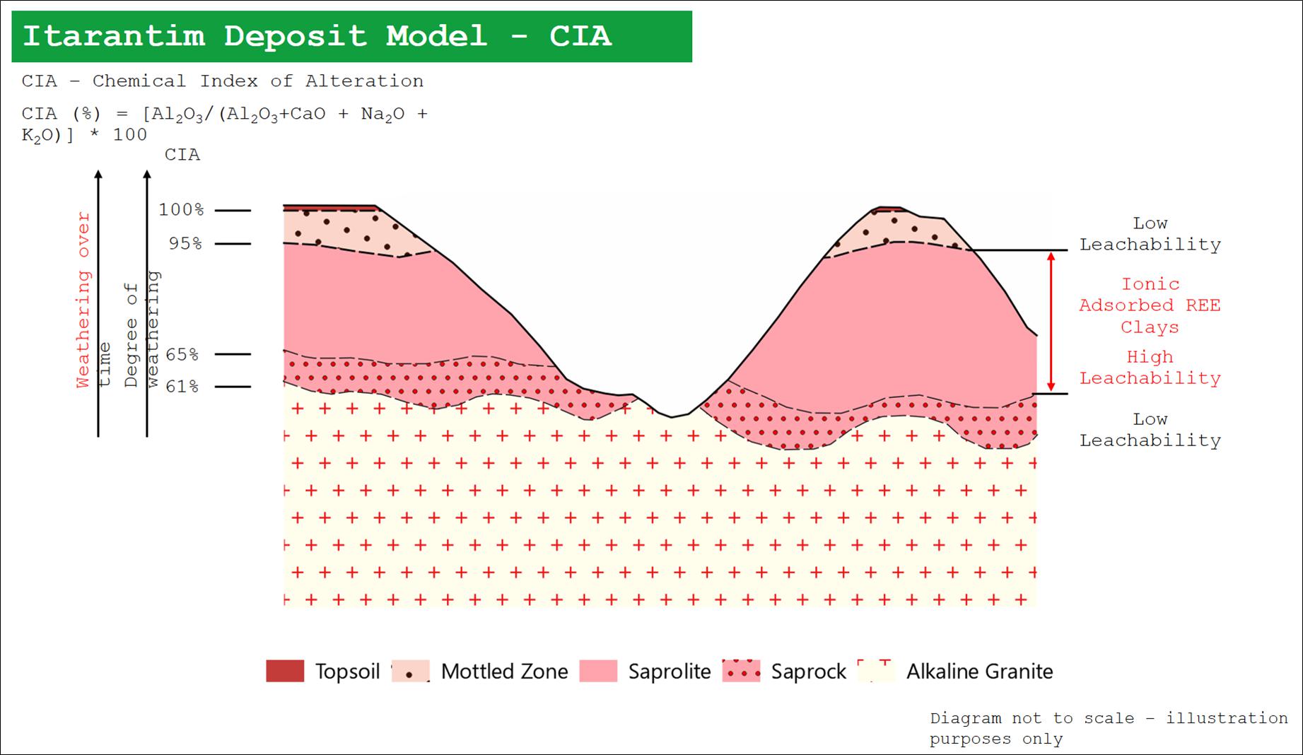
| Figure 6-2 | Schematic cross-section through Itarantim regolith (vertical exaggeration applied) |
Image source: Simon Rollason, 2024
Horizon A: REE grades tend to increase with depth below intensely weathered rock (CIA >95%) at the ground surface where REE ions are leached by surficial processes.
Horizon B: Higher REE grades are hosted in saprolite regolith (CIA ≤95% and ≥65%) preserved in the slope and plateau zones. This horizon therefore would be presumed to be the best host to IAC mineralization.
Horizon C: Lower REE grades are encountered in areas with a lower degree of weathering (CIA <65%). Lower weathering is distinguished by the greater number of grains in the sand fraction, greater presence of mafic minerals, with rock foliation that may be preserved (when the parent rock is oriented), presenting beige to pinkish colors.
Horizon D: Corresponds to parental rocks or protolith hosting primary mineralization.
The vast majority of the ion adsorption clays present a “negative cerium anomaly”, meaning that, contrary to the majority of REEs which are usually physically adsorbed as trivalent ions, Ce3+ can be easily oxidized by atmospheric oxygen (O2) to Ce4+ which then precipitates as cerianite (CeO2). Consequently, the formation of the mineral cerianite results in a natural separation of cerium from the other adsorbed trivalent REEs and makes it impossible to be recovered by ion exchange leaching.
Figure 6-3 shows a schematic cross-section of an ionic clay regolith, showing the importance of chondrite normalized curves for the identification of zones of REE enrichment and depletion, notably europium and cerium.
Depending on the nature of the original host rocks, other metals will be dissolved and transported in solution during the weathering, decomposition and alteration processes. The main impurities associated with the ion adsorption clays are usually aluminum, magnesium, calcium, manganese, zinc, and iron. An additional issue is the presence of the radionuclides uranium and thorium.
| Page 21 |
| ITARANTIM REE PROJECT, BRAZIL, TECHNICAL REPORT SUMMARY | R257,2025 |
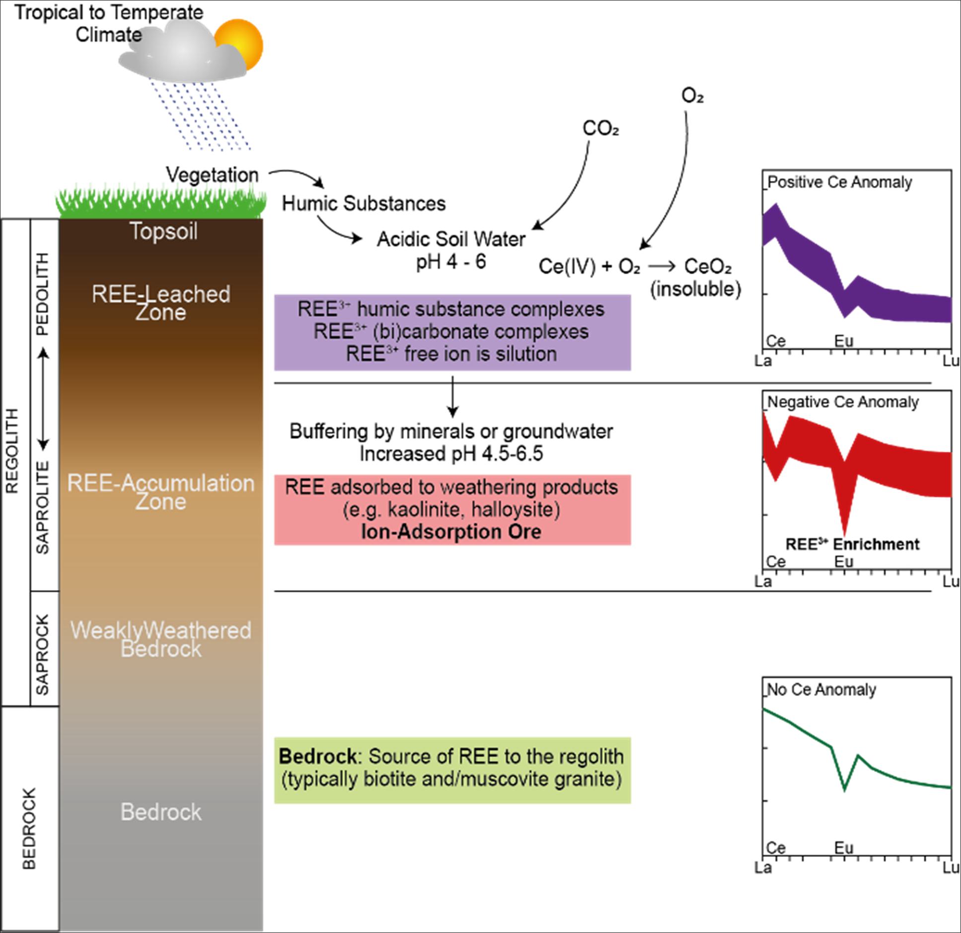
| Figure 6-3 | Stylized cross-section through a regolith hosted IAC deposit, showing cerium and europium anomalies (after Sanematsu and Watanabe, 2016) |
Discussion on the metallurgical properties of REEs and their leachabilities are provided in Section 10.
| 6.4.2 | Factors Affecting Continuity of Grade and Geology |
The ionic adsorbed clay style of deposit at Itarantim is hosted in the regolith profile above an alkaline granite. The regolith profile has an extensive areal extent and IMC has only investigated a part of the regolith across their tenure. The regolith hosts REE mineralization which therefore also has a widespread lateral extent. Development of regolith is sometimes curtailed by outcropping granite and can have a shallow depth in the valley floors.
| Page 22 |
| ITARANTIM REE PROJECT, BRAZIL, TECHNICAL REPORT SUMMARY | R257,2025 |
| 7. | Exploration |
| 7.1 | Exploration History |
There has been no previous exploration activities on the Itarantim Project prior to IMC. Exploration activities completed by IMC are described in the following sections.
| 7.1.1 | Geophysics |
An airborne geophysical survey was completed by CPRM (Serviço Geológico do Brasil) and has been used by IMC to both map prospective geology as well as identifying areas of greatest radiometric thorium response which indicates the presence of monazite and therefore REEs. This data was used to originally identify areas for follow-up geochemical sampling.
| 7.1.2 | Soil Sampling |
A program of detailed soil geochemistry was completed by IMC to identify areas of anomalous REE concentration (Figure 7-1) which was then used to assist with drillhole planning. A total of 2,291 B-horizon soil samples (including QAQC samples) were collected over the current resource blocks and analyzed at SGS Labs in Belo Horizonte. A further 727 soil samples have been collected from southern permits 831796, 870460 and 870427, where demonstration of similar geomorphological characterization to the resource blocks is present (Figure 7-2). The preliminary results in the soils in permits 831796, 870460 and 870427 show laterally persistent, over 2 km length in some instances, TREO trends >1,000 ppm TREO. These trends correlate with mapped regions of saprolite exposure, confirming the presence of an ionic adsorption deposit system in this region (Figure 7-2).
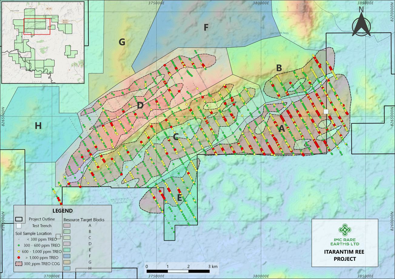
| Figure 7-1 | Soil geochemistry sample locations, by TREO ppm (block domains shown) |
Source: IMC, 2024
| Page 23 |
| ITARANTIM REE PROJECT, BRAZIL, TECHNICAL REPORT SUMMARY | R257,2025 |
Note: Trench location (adjacent to hole AD-00007) shown as white square to right of Block A.
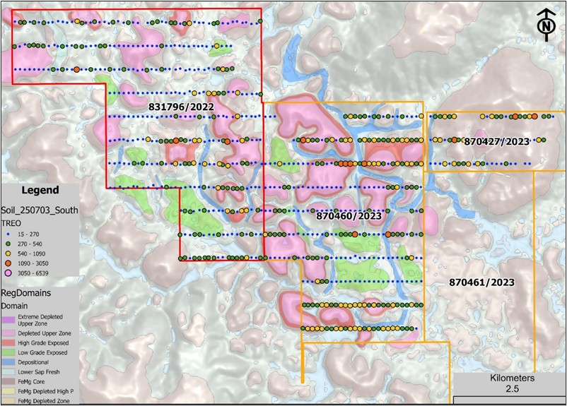
| Figure 7-2 | Soil sample locations and gridded TREO content in three permit areas |
Source: IMC, 2024
The positive identification of an ionic adsorption deposit system in the southern permits provides significant upside for potentially additional resource tonnes to the Project. However, auger drilling will be required to quantify the grade and potential tonnes.
This data was collected and collated on a weekly basis by Cacto Geologia Mineração e Meio Ambiente Ltda (Cacto Geologia) and forms the unique archive for detailing procedures and progress. It is no longer being collected because the surface did not commonly reflect the deeper parts of the regolith profile and was not used to support the current MRE.
Results from the soil geochemistry led to the delineation of regions, referred to by IMC as “blocks”. The blocks (A, B, C, D and E) are not regarded as hard grade boundaries but were established for internal reporting and progress monitoring. Auger drilling and the Mineral Resource block model clearly shows the continuity of grades across the boundaries. IMC considers the blocks to be open, with mineralization expected to continue outside these blocks. The roughly northeast–southwest trend of the blocks follows the approximate form of the historically mapped intrusive units and the data from airborne geophysics. Although useful as an earlier exploration tool, soil geochemistry only tells part of the story as IMC has demonstrated higher-grade mineralization occurring below areas of negative/low soil results, based upon drillhole sample analyses.
Blocks F, G and H have not yet been drill tested, and the current MRE does not include the areas covered by Blocks F, G and H.
| Page 24 |
| ITARANTIM REE PROJECT, BRAZIL, TECHNICAL REPORT SUMMARY | R257,2025 |
Block A covers the area south of the main northeast-southwest river valley and consists of moderate terrain. Block B lies in the northeast extents of the resource block and is truncated by a prominent east–west trending ridge, with the north of Block B having a north-facing aspect and southern Block B having a dominantly south-facing aspect. Block C lies to the north of the river valley over the southern flank of the main topographic ridge. Block D is on high ground and focuses on the “plateau” area, where the greatest thickness of regolith development is observed. Block E lies on the southern extremity of the resource blocks, with the terrain similar to the continuation of Block A to the east.
All soil samples collected are representative of each block, and there are no factors that may have resulted in sample biases.
| 7.1.3 | Trenching |
A 5 m deep by 1 m wide trench was excavated at the location of hole AD-00007 in Block A (Figure 7-3). Material was placed near the trench in piles, representing 1 m depths of excavation. The trench was backfilled following ERM’s site inspection in August 2024. The purpose of the trench was to provide twinned geological and analytical support for the drillhole AD-00007.
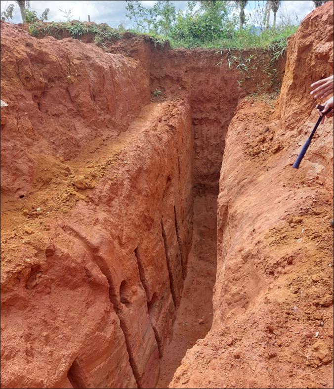
| Figure 7-3 | Trench, with channel sample holes (Block A) |
| 7.1.4 | Significant Results and Interpretation |
Soil sampling as described in Section 7.1.2 identified areas of anomalous REE concentration which was then used to assist with drillhole planning. A total of 2,291 B-horizon soil samples (including QAQC samples) were collected from within the mineral resource blocks, with a further 727 soil samples collected from southern permits 831796, 870460 and 870427, demonstrated similar geomorphological characterization to the resource blocks. The results show laterally persistent, over 2 km length, TREO trends >1,000 ppm TREO. These trends correlate with mapped regions of saprolite exposure, confirming the presence of an ionic adsorption deposit system in this region.
| Page 25 |
| ITARANTIM REE PROJECT, BRAZIL, TECHNICAL REPORT SUMMARY | R257,2025 |
The exploration trench in Block A was excavated within 20 m of drillhole AD-00007, and density penetration test hole STP4 was drilled within the trench wall. The purpose of the trench was to provide twinned verification evidence of geology and assaying. Geological logs of the drillhole and trench demonstrate similar depths for the weathering units. No other holes have been twinned.
| 7.2 | Drilling |
| 7.2.1 | Drilling Techniques and History |
All field geological and sampling activities are managed by Cacto Geologia, an independent Brazilian geological services management company contracted by IMC. Cacto Geologia employs geologists, field and sample yard technicians and prepared a set of standard operating procedures (SOPs) for the drilling and sampling activities.
Drilling commenced on the Project in May 2023. Table 7-1 presents a summary of drilling activity by year for drillholes supporting the current MRE. Holes were drilled using a coring blade attached to 1 m length rods, with rotation provided by a gas motor mounted to the head of the rod string, with downward force into the subsurface substrate provided by four operators holding onto arms of a cross-bar (Figure 7-4). The style of drilling is referred to as machine auger, although the typical spiral auger bit has not been used for the drilling at Itarantim. Five coring or percussion drill bits are used to assist with achieving maximum sample recovery and drill meterage rate, with choice of bit dependent upon ground conditions (Figure 7-5).
| Table 7-1 | Summary of drilling supporting Itarantim MRE, by year and block |
| Year | Block | No. of holes | Total depth (m) |
| 2023 | Block A | 89 | 1,081.5 |
| Block B | 2 | 19 | |
| Block C | 4 | 65 | |
| Block D | 7 | 124 | |
| Subtotal | 102 | 1,289.5 | |
| 2024 | Block A | 62 | 649 |
| Block B | 46 | 422 | |
| Block C | 205 | 2,781 | |
| Block D | 53 | 1,083 | |
| Block E | 20 | 290 | |
| Subtotal | 386 | 5,225 | |
| 2025 | Block B | 28 | 326 |
| Block D | 16 | 239 | |
| Subtotal | 44 | 565 | |
| All | Block A | 154 | 1,743.5 |
| Block B | 76 | 767 | |
| Block C | 209 | 2,846 | |
| Block D | 76 | 1,446 | |
| Block E | 20 | 290 | |
| Total | 532 | 7,079.5 | |
Note: Excludes channel sampling and holes in Blocks 460 and 796. Blocks defined in Section 7.1.2.
| Page 26 |
| ITARANTIM REE PROJECT, BRAZIL, TECHNICAL REPORT SUMMARY | R257,2025 |
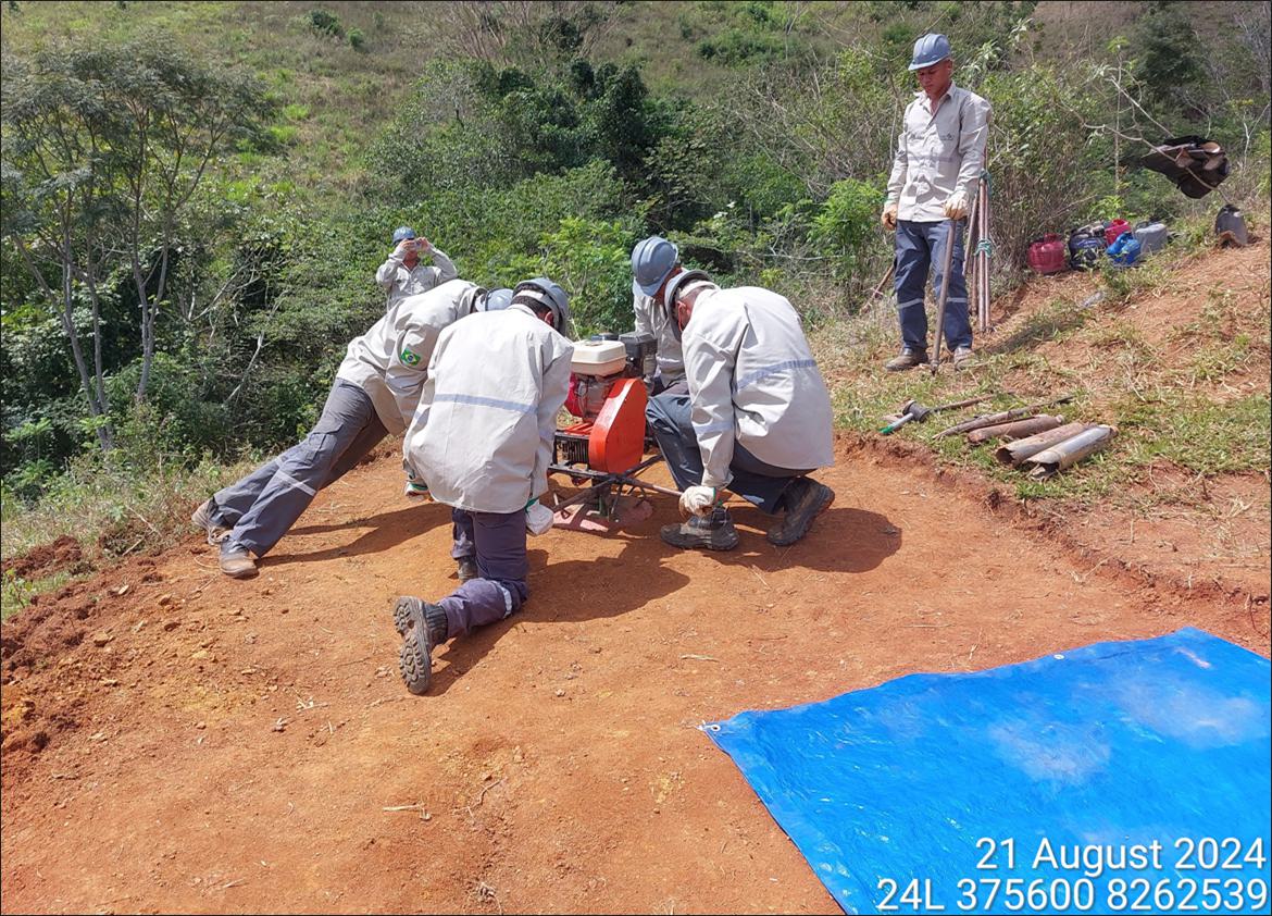
| Figure 7-4 | Drilling activity at hole AD-0412 |
| Page 27 |
| ITARANTIM REE PROJECT, BRAZIL, TECHNICAL REPORT SUMMARY | R257,2025 |
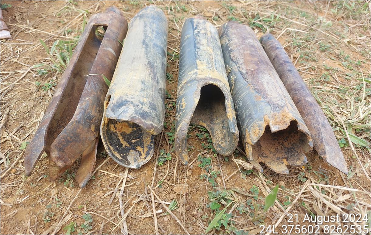
| Figure 7-5 | Auger coring blades (from left, used for soils coring, conventional coring, for harder substrate, for clays, rock breaker) |
Drilling was terminated due to lack of penetration through saprock, and in rare instances, reaching the bedrock interface.
A drillhole collar plot is presented in Figure 7-6 showing the location of holes supporting the September 2024 historical estimate and all holes drilled since September 2024, all of which support the current MRE.
| Page 28 |
| ITARANTIM REE PROJECT, BRAZIL, TECHNICAL REPORT SUMMARY | R257,2025 |
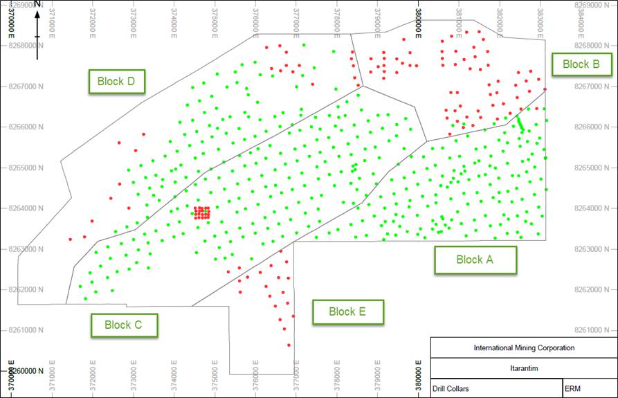
| Figure 7-6 | Drill hole collars (green holes drilled prior to September 2024 MRE, red holes drilled post September 2024 MRE); resource block outlines shown |
The choice of drilling and sampling method is considered by ERM to be appropriate for the host geological units, which ranges from unconsolidated soil through clayey horizons, friable laterites, and saprock.
| 7.2.2 | Sampling Techniques and Sample Recovery |
Machine auger drilling is used to obtain 1 m samples with mass approximately 10–12 kg, which are later subsampled and a 1.8–2.2 kg sample sent to the analytical laboratory, SGS (as defined below).
Sample recovery is generally 100% with minimal sample loss encountered, which would be due to sample falling out of core barrel during extraction of the bit from the hole. The method of drilling ensures sample compaction within the core barrel and a rubber mallet is used to tap the sides of the barrel to dislodge the sample. The barrel is cleaned with wire brush to ensure no sample contamination between meter intervals.
Samples are extracted from the coring tube at approximately 0.2 m intervals following extraction of the drill string from the ground. All advances are measured with a metal tape measure as drilling progresses. The sample is tapped out of the bit tube onto a thick plastic sheet laid on the ground near the collar (Figure 7-7). When 1.0 m of cumulative sample length is obtained, two field technicians combine all samples into one by picking up the sheet, folding it and rolling the samples around to homogenize them, then pouring into a clear plastic sample bag.
| Page 29 |
| ITARANTIM REE PROJECT, BRAZIL, TECHNICAL REPORT SUMMARY | R257,2025 |
All samples collected are representative of each block, and there are no sampling or recovery factors that may have resulted in sample biases.
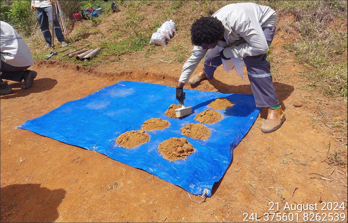
| Figure 7-7 | Sub 1 m samples laid out on plastic sheet (location – hole AD-0412) |
| Page 30 |
| ITARANTIM REE PROJECT, BRAZIL, TECHNICAL REPORT SUMMARY | R257,2025 |
| 7.3 | Logging |
All geological logging is carried out at the drill rig. The field technician, under supervision from a Cacto Geologia geologist, logs each 1 m sample for color, grainsize and mineralogy. The level of detail is considered appropriate to support Mineral Resource estimation.
Logging is qualitative in nature, based upon the technicians’ observations and judgement. All samples are logged. Photographs of the sample chip trays are taken in uniform lighting conditions.
| 7.4 | Location of Data Points |
| 7.4.1 | Topography Data |
A light detection and ranging (LiDAR) survey was flown in August 2024 by Aerosat Engenharia e Aerolevantamentos Ltda (Aerosat). Results from the LiDAR were used to generate a topographic digital terrain model (DTM) at a resolution of 0.1 m. This survey was extended in March 2025 to allow full coverage of the resource blocks and extend to areas of future exploration (Aerosat, 2025).
To allow for a workable 3D mesh, the LiDAR data was reduced to 5 m node spacing and a 3D mesh was generated in Geosoft Oasis software, which was then exported as a 3D Leapfrog mesh. To allow for geological extrapolation beyond the LiDAR boundaries, Shuttle Radar Topography Mission (SRTM) topography points on 25 m spacing were merged with the LiDAR mesh (Figure 7-8). The mineralization envelope and geological model were subsequently trimmed to the resource block model boundary, which also represents the boundaries of the LiDAR survey.
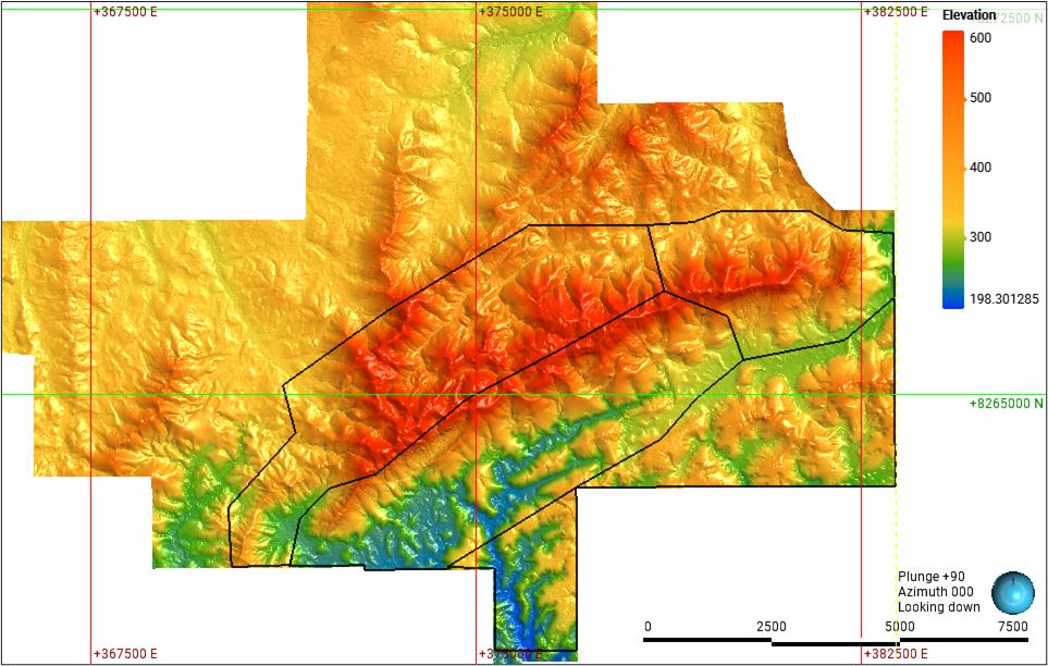
| Figure 7-8 | LiDAR survey boundary (black polyline) with 2 m 3D mesh inside and 25 m SRTM mesh outside |
| 7.4.2 | Collar Data |
Drill collars were surveyed by Cacto Geologia staff using a handheld global positioning system (GPS) in the first instance and later surveyed using a real-time kinematic (RTK) GPS unit (CHCNAV i73 GNSS). Collar elevations were later registered to the LiDAR topographic DTM to obtain a reliable elevation for the collars.
| Page 31 |
| ITARANTIM REE PROJECT, BRAZIL, TECHNICAL REPORT SUMMARY | R257,2025 |
| 7.4.3 | Downhole Survey Data |
All holes are vertical and drilled to relatively shallow depths. Any deviation in drilling with depth is expected to be minimal and not material, therefore, downhole surveys are not considered to be required.
| 7.5 | Data Spacing and Orientation |
Drillholes are presently spaced approximately 320 m apart, both along drill lines and between lines. A grid of holes was drilled by IMC in 2025 in Block C with a spacing of approximately 90 m(X) by 80 m(Y), with drillhole IDs of AD-00470 to AD-00488. The rugged topography has resulted in some variability in collar elevations within relatively close distances between holes. A drill hole collar plot is presented in Figure 7-6. The data spacing and distribution are considered by ERM to be sufficient to establish the degree of geological and grade continuity to support the estimation of a Mineral Resource.
| 7.6 | Orientation in Relation to Geological Structure |
The holes were drilled vertical, which is orthogonal to the distribution of the weathering profile.
| 7.7 | Material Results and Interpretation |
Itarantim is an ionic adsorption clay REE deposit hosted in clays of the regolith above an alkali granite. The majority of REE in the alkaline granites at Itarantim are assumed to be included within the mineral monazite. Monazite is generally resistant to prolonged weathering or erosion and may be concentrated through elluvial enrichment. Monazite forms an important part of the mineral assemblage in heavy mineral sand deposits and may be recognized on its radiometric response, due to commonly containing between 1% and 4% ThO2.
The ion adsorption clays contain between 0.05% and 0.3% REE, from which 60–90% occur physically adsorbed onto clay minerals, notably kaolinite and halloysite. They are recoverable by using simple inorganic salt solutions where, during the leaching process, the REE are relatively easily transferred into solution as soluble sulphates or chlorides, depending on if a salt solution (NaCl) or ammonium sulphate is used as lixiviant.
As mineralisation is hosted in the regolith, regolith domains were identified on the grounds of whole rock element (K2O, Na2O, Al2O3, CaO, MgO, Fe2O3 and MnO) and TREO geochemical profiles. Units defined within domains were identified, from top down, as (1) Depleted Zone (2) Upper Transition Zone, (3) Enriched Zone, (4) Lower Transition Zone, and (5) Fresh Rock.
The drillhole spacing and the resolution of the block model do not support the subsetting of the mineralised envelope and subsequent block model reporting per unit. As a result, the boundaries used for modelling were simplified into Hanging Wall (Depleted Zone), Min 630 (630 cut + Upper Transition Zone + Lower Transition Zone) and Footwall (Fresh).
Mineralisation is generally restricted to the top 15–20 m of the regolith profile, and the depth of drilling is considered appropriate. However, a number of areas were encountered where mineralisation was found to extend beyond the depth of present drilling at 20 m. The mineralisation is generally tabular and stratiform and generally follows the topography.
A high level of confidence is placed on the current geological model, given the amount of drilling, geological understanding and observations made in the field. The confidence in the geological interpretation is reflected in the Mineral Resource classification levels assigned to the Mineral Resource estimate.
| Page 32 |
| ITARANTIM REE PROJECT, BRAZIL, TECHNICAL REPORT SUMMARY | R257,2025 |
Major element geochemistry is used as an effective guide to distinguish the various regolith units, as well as the units which demonstrate the best leach results. Continuity is affected by localized drainages as well as slumping which has, in places, caused localized mixing of regolith types.
Geological models were based upon drillhole samples, including geological logs of lithology and weathering, and sample assays. The geological models guided the Mineral Resource estimation, with sample populations for the TREO mineralisation statistically reviewed.
The geological models extend along and across strike of the deposit with all drillhole data available as at the database cutoff date used to support the geological models. Mineralisation beyond the limits of the geological models are observed and will be drill tested by IMC.
One geological model was prepared using Leapfrog software, using a 630 ppm TREO lower cut-off grade. The continuity of grade is interpreted as continuing along and across strike. The host regolith exhibits continuity along the valleys, flanks and lower hills. Regolith has not developed on mountain summits or very steep topography (>80° inclination) and is noted to be very thin (<3 m) along valley floors.
The Mineral Resource extends 11,400 m along strike, across strike for 5,200 m, and the base of the regolith model extends down dip to a depth of >20 m below surface and usually is 6–10 m in thickness.
For mineralisation contained within Block E, the Mineral Resource extends 1,700 m along strike, and across strike for 2,600 m.
| 7.8 | Hydrogeology |
IMC has recently engaged the services of WSP, an international environmental consulting group with offices in Brazil, to provide hydrogeological services. The work has only recently started and is currently in progress. WSP has completed the compilation and analysis of existing geological and hydrogeological data in the area and plans are underway for the Company to work with WSP to drill and install a network of groundwater monitoring wells in and around the area, with the objective of advancing the understanding of the hydrogeological conditions on the Project.
| 7.9 | Geotechnical |
No geotechnical work or studies have been conducted by or on behalf of IMC.
| Page 33 |
| ITARANTIM REE PROJECT, BRAZIL, TECHNICAL REPORT SUMMARY | R257,2025 |
| 8. | Sample Preparation, Analyses and Security |
| 8.1 | Subsampling Techniques and Sample Preparation |
| 8.1.1 | Itarantim Sample Yard |
The Itarantim sample preparation facility owned by IMC is a secure compound with the following features:
| ● | Vehicle access for delivery and dispatch of samples |
| ● | A well laid-out sample preparation area, with a roof and fans to provide a comfortable work environment |
| ● | Office building, for field technicians to carry out data entry into laptops |
| ● | Yard for storage of archived samples |
| ● | Mechanical workshop for maintenance of auger machines. |
Samples received from the field are stored in the sample preparation area. The following steps are followed for subsampling, with greater detail provided in SOP-00-002:
| 1) | Weigh the full sample. |
| 2) | Screen the samples over a quarter sampler to remove coarse clusters; these are broken down if possible. |
| 3) | Two opposite quartered samples are removed and bagged as reject. |
| 4) | The remaining two quartered samples are homogenized and poured through the screen mesh for a second quarter sampling. |
| 5) | The first two quartered samples are placed into a plastic bag and are treated as the primary sample. |
| 6) | The remaining quartered samples are bagged and treated as the field duplicate. |
| 7) | Samples are weighed to confirm the primary and field duplicate bags are of similar weights. |
| 8) | Bags are ticketed and stored ready for dispatch to the applicable analytical laboratory. |
| Page 34 |
| ITARANTIM REE PROJECT, BRAZIL, TECHNICAL REPORT SUMMARY | R257,2025 |
A selection of subsampling steps is shown in Figure 8-1.
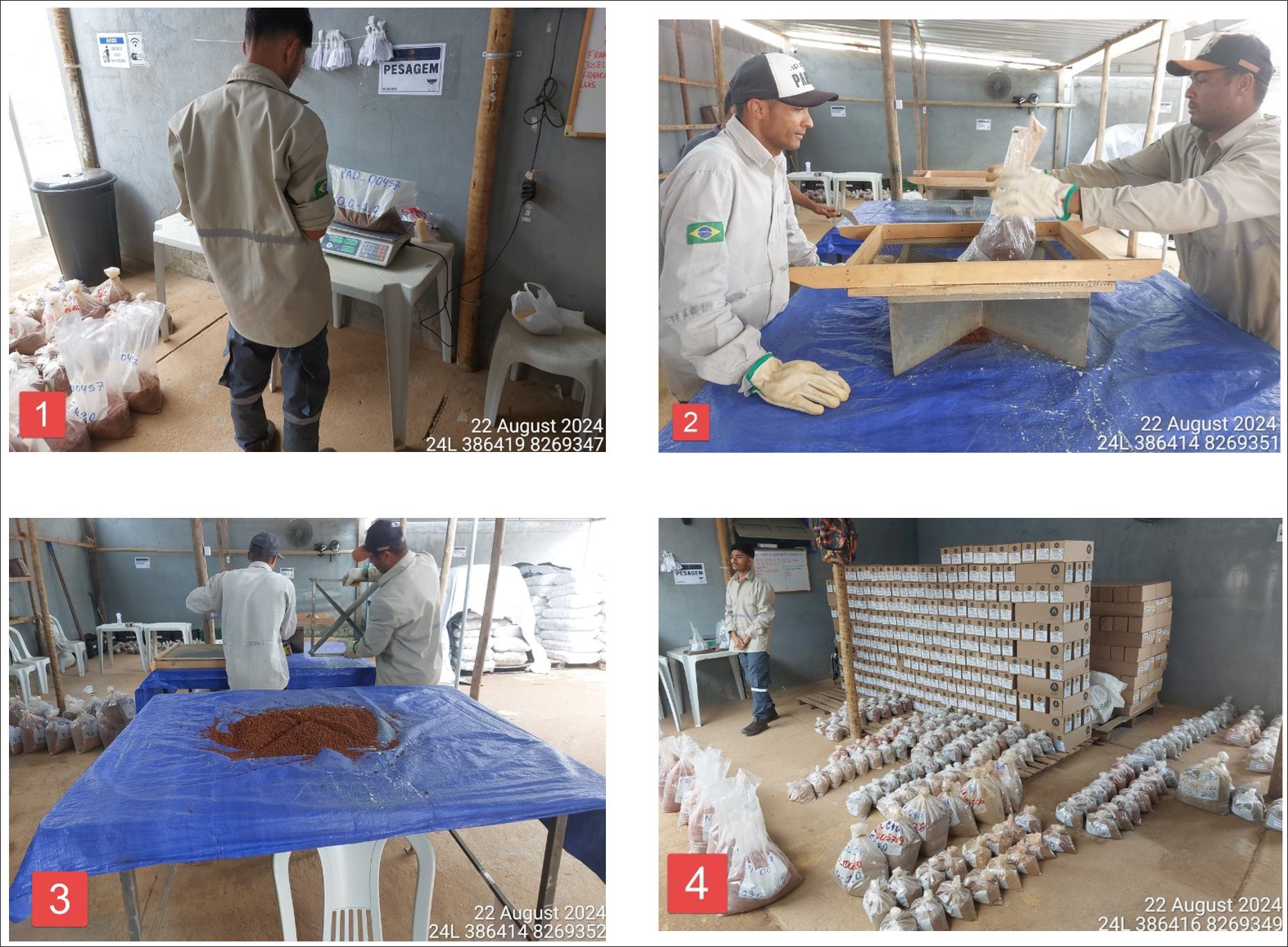
| Figure 8-1 | Sample preparation at Itarantim sample yard – (1) weighing sample; (2) screening and quartering of sample; (3) quartered sample; (4) sample bags ready for distribution, returned pulps in boxes |
| 8.2 | Sample Analyses |
| 8.2.1 | Summary |
Subsamples for each drillhole meter sample are dispatched to the analytical laboratory for sample analyses. Samples from drillholes up to and including AD-00140 were dispatched to SGS Laboratory (SGS) in Belo Horizonte, but due to poor assay turnaround time (the time taken for delivery of assay results from the moment of receipt of sample), IMC commenced using ALS Global (ALS) in Belo Horizonte for sample analyses. The majority of samples tested by SGS were located in Block A. SGS is an ISO/IEC 17025 accredited laboratory that is independent of IMC.
| 8.2.2 | SGS Laboratory |
SGS used the following procedures for sample preparation and analysis:
| 1) | Drying of samples at 105° for 12 hours. |
| 2) | Crush to 3 mm with 75% passing. |
| 3) | Pulverize to <150 mesh (approximately 90 µm) with >95% passing. |
| 4) | 250 g sample taken for analysis. |
| 5) | Analysis by lithium metaborate fusion determination (inductively coupled plasma-mass spectrometry – ICP-MS). |
| Page 35 |
| ITARANTIM REE PROJECT, BRAZIL, TECHNICAL REPORT SUMMARY | R257,2025 |
| 8.2.3 | ALS Global |
Samples from drillhole AD-00141 onwards were dispatched to ALS (Belo Horizonte) for subsampling to produce a pulp sample, which were dispatched to ALS (Lima) for analysis. ALS is an ISO/IEC 17025 accredited laboratory that is independent of IMC.
Sample analysis is by ICP-MS which provides analyses for whole rock major element chemistry as well as for individual REEs. This technique is regarded as appropriate by ERM. ALS used the following procedures for sample preparation and analysis:
| 1) | Split sample with riffle splitter. |
| 2) | Pulverize to <75 µm with 85% passing. |
| 3) | 250 g sample taken. |
| 4) | Whole rock package analysis ICP-atomic emission spectroscopy (AES). |
| 5) | Lithium borate fusion ICP-MS. |
| 8.2.4 | Leach Test |
A subset of samples, selected by IMC geologists, are submitted for leaching tests at ALS, using a weakly acidified ammonium sulfate as the lixiviant. Discussion is provided in Section 10.
| 8.3 | Sample and Data Security |
All samples were securely transported to the IMC sample storage facility in Itarantim at the end of each day by Cacto Geologia staff. The samples were locked in the secure compound. Samples were transported to the ALS sample preparation facility in Belo Horizonte once per week, driven by a Cacto Geologia employee, where the samples came under the ALS chain of custody and security protocols upon receipt of delivery.
| 8.4 | Quality Assurance |
| 8.4.1 | Summary of Procedures |
QAQC involves the use of certified reference material (CRM) assay standards, blanks, field duplicates, laboratory replicate assaying (pulps) and umpire analyses for laboratory QAQC measures. CRMs were sourced from ORE Research & Exploration Pty Ltd (OREAS) and are certified for rare earths.
The ratio of primary-to-quality control samples is set at 5% duplicates, 5% blanks and 5% CRM submitted to the laboratory to ensure the QAQC protocols are followed. This is audited by the database management consultancy Earth SQL, which reports any potential errors in the analytical process or deviations from the required processes. IMC has a SOP regarding response to failures in the quality control results.
| 8.4.2 | Certified Reference Materials |
Table 8-1 presents the REE certified results for the battery REEs and cerium for the three CRMs used by IMC at Itarantim. The certified results are sourced from OREAS certificates of analysis and are for the ICP analyses, being the same analytical process as used to analyze the REEs from the primary samples. IMC regards a CRM to have analytically failed if its assay falls outside the 3 standard deviation (SD) tolerance.
| Page 36 |
| ITARANTIM REE PROJECT, BRAZIL, TECHNICAL REPORT SUMMARY | R257,2025 |
| Table 8-1 | CRMs – selected data |
| CRM | REE | Certified value (ppm) | 1 SD |
OREAS 30a Very low level REE basalt blank material |
Ce | 58 | 3.2 |
| Dy | 1.19 | 0.163 | |
| Nd | 27.4 | 1.55 | |
| Pr | 7.05 | 0.565 | |
| Tb | 0.75 | 0.06 | |
OREAS 100a Moderate to low TREE values that is uranium-bearing |
Ce | 463 | 29 |
| Dy | 23.2 | 0.9 | |
| Nd | 152 | 14 | |
| Pr | 47.1 | 4 | |
| Tb | 3.8 | 0.34 | |
OREAS 460 High TREE carbonatite supergene material |
Ce | 1,798 | 72 |
| Dy | 19.8 | 0.75 | |
| Nd | 781 | 47 | |
| Pr | 244 | 8 | |
| Tb | 4.84 | 0.212 |
| 8.4.3 | Field Duplicates |
Field duplicates are taken at the sample preparation stage as undertaken at the Itarantim sample yard, as discussed in Section 8.1.1.
| 8.4.4 | Blanks |
Blank material utilized for the Project is ITAK QI-01 CRM with known values outlined in ITAK Certificate of Analysis 0484.
The blank was sourced from a white quartz with assays determined by ICP-MS. The certified values (ppm) for selected REEs are: cerium (0.85); terbium (<0.05).
| 8.5 | Quality Control Results |
| 8.5.1 | Certified Reference Materials |
CRM performance charts for neodymium are presented in Figure 8-2 for results received from ALS during the period 1 September 2024 to 10 June 2025. CRM performance charts for praseodymium, dysprosium and terbium were also generated. Full sets of results, by batch and by project to date, can be viewed in IMC (2024, 2025). The X-axis is the date of sampling, and therefore, the chart results are plotted in chronological order. The results from dysprosium and terbium in CRM “OREAS460” are presented in Figure 8-3 and show multiple results falling above the +2 SD line and several failures above the 3 SD line. Performance charts for CRM 100a are shown in comparison, which shows the assay results are within the acceptable data limits for that CRM. ERM consider the higher-grade heavy REE assays from OREAS460 might be over-called, implying that high grade sample assays might return higher dysprosium and terbium assays than the expected true sample grade. ERM recommended that IMC investigates the reasons for these results.
Apart from the issue noted with dysprosium and terbium, the CRMs have performed generally well.
| Page 37 |
| ITARANTIM REE PROJECT, BRAZIL, TECHNICAL REPORT SUMMARY | R257,2025 |
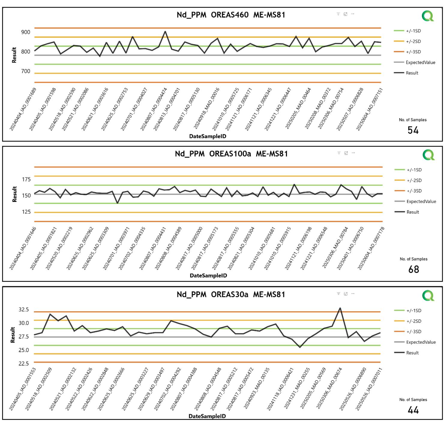
| Figure 8-2 | CRM performance charts, neodymium (sample assays from 1 September 2024 to June 10 2025) |
| Page 38 |
| ITARANTIM REE PROJECT, BRAZIL, TECHNICAL REPORT SUMMARY | R257,2025 |
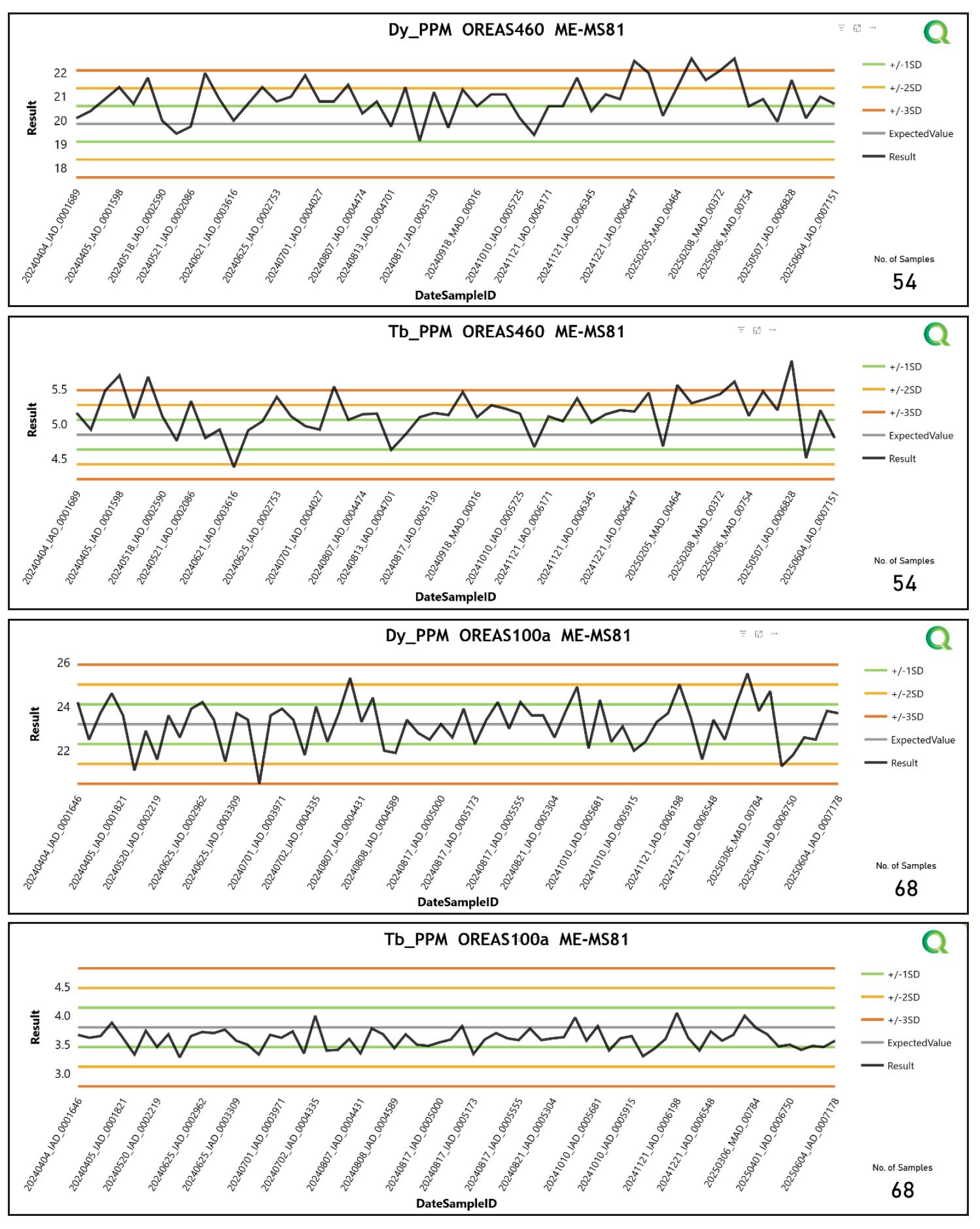
| Figure 8-3 | CRM performance charts OREAS460 and 100a, dysprosium and terbium (sample assays from September 1, 2024 to June 10, 2025) |
| 8.5.2 | Field Duplicates |
Performance charts for field duplicates for neodymium are presented in Figure 8-4. The results are reasonable and indicate that the field duplicates have performed well.
| Page 39 |
| ITARANTIM REE PROJECT, BRAZIL, TECHNICAL REPORT SUMMARY | R257,2025 |
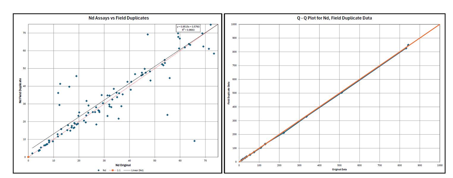
| Figure 8-4 | Scatterplot and quantile-quantile plot, field duplicates, neodymium (ppm) |
| 8.5.3 | Blanks |
Performance charts for selected REE blank assays are presented in Figure 8-5 and demonstrate reasonable performance.
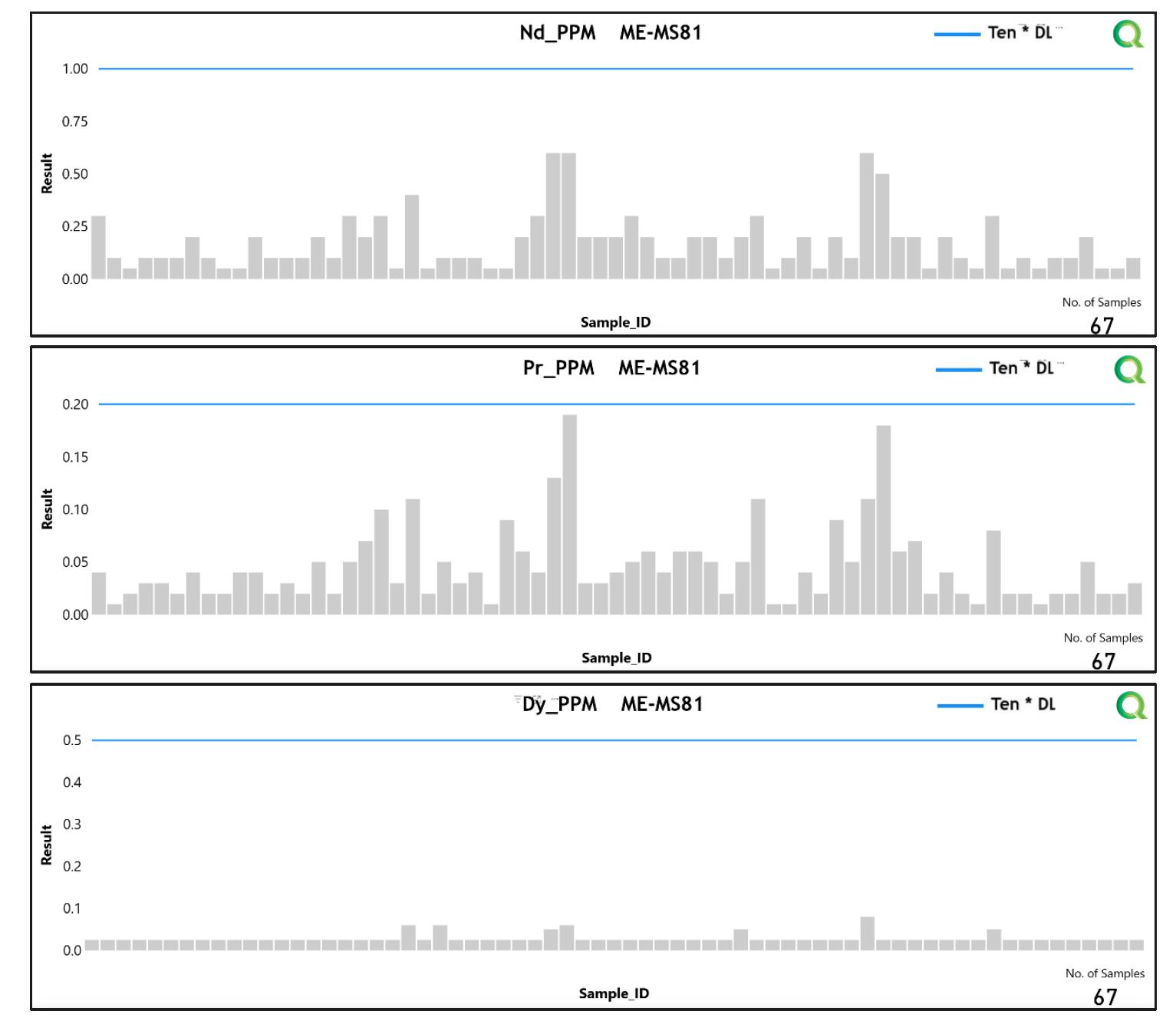
| Page 40 |
| ITARANTIM REE PROJECT, BRAZIL, TECHNICAL REPORT SUMMARY | R257,2025 |
| Figure 8-5 | Performance charts, quality control blanks |
| 8.5.4 | Umpire Laboratory Results |
A subset of the early completed auger holes was submitted for elution leach testing at the laboratory, the Nuclear Technology Development Center (CDTN) in Belo Horizonte. CDTN is an ISO/IEC 17025 accredited laboratory that is independent of IMC. Initial results showed ionic adsorbed leach results of the 119 samples to be highly significant, with over 36% reporting in excess of 50% leach, and 8.4% reporting a >80% leach.
A subset of replicate samples (n=20 from four holes) was sent to the University of Brighton (UK) for umpire leach testing, with results successfully replicated (Smith and Grove, 2024). The University of Brighton is independent of IMC. IMC is uncertain of the accreditation and certification of this particular laboratory.
No other umpire testing has been conducted.
| 8.6 | Qualified Person Opinion |
In ERM’s opinion, data has been collected, sampled, subsampled, and analyzed in a manner that meets or exceeds current industry standards. Additionally, security measures around sample handling, storage and transport meet current industry standards. In addition, sample preparation, security and analytical procedures are adequate to support the MRE.
| Page 41 |
| ITARANTIM REE PROJECT, BRAZIL, TECHNICAL REPORT SUMMARY | R257,2025 |
| 9. | Data Verification |
| 9.1 | Site Visit Details |
An employee of ERM visited the Project between August 20 and 22, 2024. The following aspects of the Project development were reviewed and considered to be acceptable for supporting the MRE:
| ● | Review of topographic and geomorphic expression |
| ● | Verification of a selection of drillhole collar surveys |
| ● | Inspection of IMC sample preparation yard and review of subsampling procedures |
| ● | Discussions regarding Project development and future Mineral Resource development activities |
| ● | Form a judgement regarding reasonable prospects for economic extraction (RPEE). |
ERM did not visit the analytical laboratories, and it was recommended that IMC conducts regular inspections of the laboratory and recommends at least one visit per drill program.
| 9.2 | Database Verification and Validation |
ERM also assessed a selection of data, and relied on verification observations and analysis during the site visit, as well as independently peer reviewing the MRE and input data to satisfy themselves that the quality and quantity of input data is appropriate for the purpose of generating a MRE and supporting the data reported in this TRS.
| 9.3 | Verification of Sampling and Assaying |
| 9.3.1 | Visual Inspection |
IMC geologists and consulting exploration geologists independently verified high-grade assays against chip tray samples.
| 9.3.2 | Twin Drilling |
Hole AD-00007 was drilled within 20 m of an exploration trench, and density penetration test hole STP4, drilled within the trench wall. Geological logs of the drillhole and trench demonstrate similar depths for the weathering units. No other holes have been twinned.
| 9.3.3 | Data Excluded |
All auger drillholes up to AD-00532 are included in the Mineral Resource. Sample assays and associated drillhole geology collars and logs from hole AD-00532 onwards are not included.
The reason for this was a database cut-off date was required to allow for modelling and resource estimation to proceed at a given point in time without adding new holes. Assays were still outstanding for drill holes form AD-00532. ERM is of the opinion that the excluded data is not material to the MRE reported in this Report. All other holes drilled after AD-00532 are expected to be incorporated into the next update of the MRE.
| Page 42 |
| ITARANTIM REE PROJECT, BRAZIL, TECHNICAL REPORT SUMMARY | R257,2025 |
| 9.4 | Qualified Person Verification and Opinion |
ERM conducted a detailed independent verification of the exploration, sampling and analytical data used to support the MRE for the Itarantim Project. In summary, the verification program included:
| ● | Review of original field sampling records, chain-of-custody forms, and laboratory certificates for a representative selection of drillholes and trenches |
| ● | On-site inspection of drill collar locations using a handheld GPS, confirming positional accuracy within ±2 m of surveyed coordinates |
| ● | Confirmation that the drillhole database maintained by IMC is internally consistent and free of critical errors such as overlapping intervals, missing assays, or mismatched collar and survey data |
| ● | Reconciliation of downhole logs, assay tables, and collar files within the master database used for resource estimation |
| ● | Cross-checks of analytical results between primary (ALS Global Belo Horizonte) and secondary laboratories (SGS Brazil), confirming that assay bias is not material |
| ● | Evaluation of QAQC performance including CRMs, blanks, duplicates, and umpire analyses, all of which were found to be within acceptable industry tolerance limits (typically ±2 SD of certified values). |
The database validation process did not identify any material errors or omissions that would materially affect the MRE for the Project. Minor transcription inconsistencies were corrected in consultation with IMC’s database management team.
Based on this review, ERM is satisfied that the geological, analytical, and spatial data are accurate, complete, and reliable for use in mineral resource estimation. The data verification procedures undertaken are consistent with current industry best practice and meet the requirements under S-K 1300.
ERM notes that future infill drilling and additional dry density determinations are recommended to further enhance confidence in geological continuity and tonnage estimates; however, these limitations do not affect the validity of the current Inferred Mineral Resource classification for the Project.
| Page 43 |
| ITARANTIM REE PROJECT, BRAZIL, TECHNICAL REPORT SUMMARY | R257,2025 |
| 10. | Mineral Processing and METALLURGICAL Testing |
| 10.1 | General Summary |
| 10.1.1 | History of Processing Ionic Adsorption Deposits |
Since the discovery of ionic adsorbed REE mineralization in the Jingxi Province of China approximately 50 years ago, China has been at the forefront of research and development of processing these deposits. The first-generation leaching technology, introduced in the early 1970s, was carried out using batch leaching with NaCl. Mineral processing was by means of open cast mining, sieving and leaching with ~1M NaCl in barrels, followed by oxalic acid precipitation. The main disadvantages of this initial approach were the small scale, low yields, high lixiviant concentrations needed and poor product quality (<70% TREO content due to sodium oxalate precipitation).
Extraction of the REE from ionic adsorption deposits is currently active only in China and Myanmar. All operations today make use of ammonium sulfate ((NH4)2SO4) leach solutions, which in experimental studies can achieve 60–90% REE extraction.
| 10.1.2 | Current Processing and REE Extraction Methods |
Prior to 2008, extraction was dominated by heap or tank/pool leaching, but subsequently, in-situ leaching has become more prevalent. Both technologies produce a lower yield than laboratory leaching experiments, with high concentrations of REE remaining in tailings. In-situ leaching operations use PVC-lined injection boreholes of 0.6–0.8 m diameter and between 2 m and 6 m depth, typically with 5 m spacing. Leachate collection wells are drilled either at the base of slopes or in terraces. After a period of leachate injection, the system is typically flushed with fresh water to drive out any remaining leach solution. The REE are precipitated from the resulting solutions using either ammonium bicarbonate or oxalic acid and then calcined to produce mixed rare earth carbonate or oxides, respectively.
The ion adsorption clays in China contain between 0.05% and 0.30% REE, from which 60% to 90% occur physically adsorbed onto clay minerals, notably kaolinite and halloysite. As stated, they are recoverable by using simple inorganic salt solutions where, during the leaching process, the REEs are relatively easily transferred into solution as soluble sulfates or chlorides, depending on whether a salt solution (NaCl) or ammonium sulfate is used as lixiviant.
These solubilized REEs are then precipitated with oxalic acid to form an REE oxalate, which is then converted to mixed REOs by roasting at 900°C. Finally, the mixed REOs are separated into individual REE by dissolution in hydrogen chloride (HCl), and fractional solvent extraction is applied to separate the individual REEs. This is illustrated in Figure 10-1, showing a generic flowsheet detailing the process commonly applied in REE mineral extraction and REE concentrate processing. Early phases indicated in blue are where significant losses (low recoveries) are experienced (after Verbaan et al., 2015). The ionic side of the process is outlined in orange.
| Page 44 |
| ITARANTIM REE PROJECT, BRAZIL, TECHNICAL REPORT SUMMARY | R257,2025 |
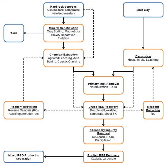
| Figure 10-1 | Generic flowsheet detailing processes commonly applied in REE mineral extraction and REE concentrate processing (after Verbaan et al., 2015) |
Research conducted on the desorption of REE from clays via ion-exchange leaching has indicated that, regardless of the initial content, not all REE reach similar extraction levels. This is well illustrated in the cross-section displayed in Figure 10-5 from Itarantim, where these differences in leachability are indicated. It has been reported the amount of trivalent REE ions that are adsorbed on smectite and kaolinite is inversely proportional to the ionic radii (Pavez et al., 1996). Therefore, the heavy REEs (higher atomic numbers from gadolinium to lutetium) are adsorbed preferentially compared to the light REEs (lanthanum to europium).
Ease of extraction therefore will occur in the following manner over time:
| ● | Sc > La > Ce > Pr > Nd > Sm > Eu > Gd > Tb > Dy > Ho > Y > Er > Tm > Yb > Lu. |
While most base metals occur as part of the mixed mineral phase and do not leach out during the mild ion-exchange REE leaching conditions, aluminum, especially and to a lesser extent calcium and magnesium, constitute the major impurities physically adsorbed on clays that are liable to get desorbed during the process along with the REE.
| Page 45 |
| ITARANTIM REE PROJECT, BRAZIL, TECHNICAL REPORT SUMMARY | R257,2025 |
| 10.1.3 | Itarantim Ionic Adsorption Deposit |
In the Project areas visited in the field by IMC and ERM, the outcropping rocks, as well as the climate, slope and geomorphological setting, are all supportive of the presence of ionic adsorption deposit REE mineralization at Itarantim. Leach testing of representative material also supports the presence of such mineralization. A review of the geomorphology indicates that the area is undergoing erosion, and that mass slumping is an important means of sediment transport. This has resulted in a complex regolith being developed with the possibility of truncated regolith profiles and the possible movement of saprock and saprolite being incorporated above mature pedolith zones (Figure 10-2).
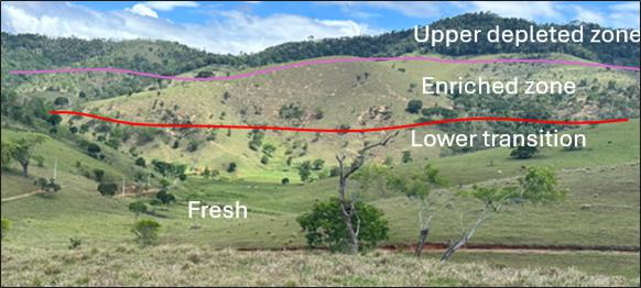
| Figure 10-2 | The north-facing slope of Block D with exposed mineralized saprolite domains in truncated regolith |
| 10.2 | Metallurgical Testwork for Itarantim Project |
Several phases of metallurgical testwork have been carried out by IMC during the Project investigation. These phases can be broken down by: (i) early verification; (ii) progress monitoring and selective sampling; and (iii) channel sampling. The total amount of leach testwork completed on the Project includes 142 auger holes and 3 channel samples for a combined total of 1,917 samples spanning the resource area (Table 10-1, Figure 10-3).
| Table 10-1 | Summary of metallurgical sampling undertaken on the Itarantim Project to date |
| Sample phase | No. holes | No. samples | Comment |
| IAD verification | 9 | 119 | Used to verify ionic leachability and determine leach % |
| Verification umpires | 4 | 20 | Umpire of IAD verification and additional XRD |
| XRD | 9 | 20 | Kaolinite/halloysite dominant clay mineralogy |
| Monitoring and selective | 142 | 1,917 | Sampling throughout the duration of drilling and later selected MREO domains |
Note: IAD = ionic adsorption deposit; XRD = x-ray diffraction.
| Page 46 |
| ITARANTIM REE PROJECT, BRAZIL, TECHNICAL REPORT SUMMARY | R257,2025 |
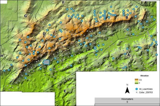
| Figure 10-3 | Complete map of samples selected for leach data across the resource area |
Source: IMC, 2024
When presenting leach testwork, CeO2 is not included in leach results due to Ce3+ being easily oxidized by atmospheric oxygen (O2) to Ce4+ and the subsequent precipitation of the mineral cerianite (CeO2), which is not recoverable by ion-exchange leaching. Therefore, all leach testwork is quoted as TREE-Ce leach %, LREE-Ce leach %, and HREE leach %.
Statistical investigation utilizing histograms and log probability plots of the leach data indicates a common break at 40 leach % for both LREE and HREE (Figure 10-4). This data also indicates there is a greater proportion of HREE >40 leach % than there is LREE. Composites of both LREE and HREE >40 leach %, constrained within the ≥630 ppm mineralized envelope, were made, allowing an average leach % of intersections, representative of modeled mineralization, to be quantified and graphically displayed.
| Page 47 |
| ITARANTIM REE PROJECT, BRAZIL, TECHNICAL REPORT SUMMARY | R257,2025 |
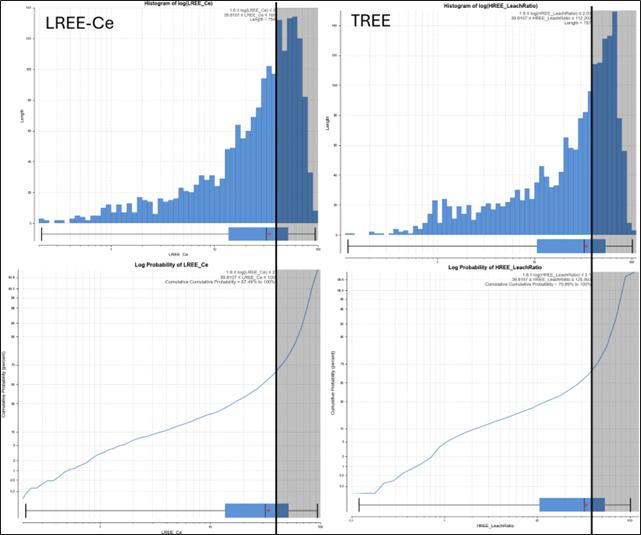
| Figure 10-4 | Statistical analysis of leach % data for both LREE and HREE, showing a break at 40 leach % utilized for compositing intersections within the mineralized envelope |
| 10.3 | Early Verification Metallurgical Testwork |
The early verification metallurgical testwork was executed by IMC to determine the nature of the REE mineralization and if it was amenable to leaching by standard lixiviants such as weak solutions of ammonium sulfate solution or sodium chloride. This would determine if the mineralization could be classified as an IAC deposit. A total of 114 samples from 9 auger holes (AD-00001 to AD-00009) were submitted for elution leach testing at the laboratory of the CDTN in Belo Horizonte. The leached solution was analysed by SGS laboratories utilizing their ICP95A package (lithium borate fusion with ICP-MS). The ratio of leach data/original assay was used to calculate the leach %. These test samples were specifically selected as representative of the various types and styles of REE mineralization at Itarantim.
A composite of the results obtaining TREE-Ce >40% leach demonstrated a mean leach % of 60%, with a minimum leach % of 45% and maximum leach % of 74%. These results demonstrate that the REE mineralization encountered in the drilling may be classified as ionically adsorbed, and the mineral system classified as an ionic adsorption deposit, with the leach % achieved in line with current producers such as Longnan in China (Li et al., 2017).
| Page 48 |
| ITARANTIM REE PROJECT, BRAZIL, TECHNICAL REPORT SUMMARY | R257,2025 |
A further 21 duplicate samples were sent to the University of Brighton (UK) for additional testing and verification including x-ray diffraction (XRD) (Table 10-2) and near infrared (NIR) for clay mineral identification. The results of this work were positive, with the shallow parts of the regolith largely composed of kaolinite and/or halloysite, being the most important clay minerals which host adsorbed REE. Furthermore, the leach studies were successfully replicated, verifying the initial testwork undertaken by CDTN, as discussed in Section 8.5.4 (Smith and Grove, 2024).
| Table 10-2 | Summary of XRD results undertaken at Brighton University |
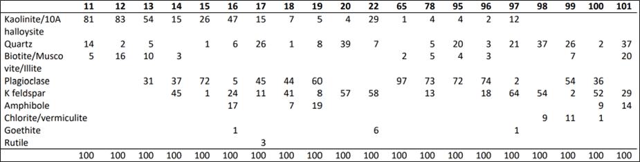
Additional studies on cationic exchange capacities as well as settling were completed by Smith and Grove (2024). Settling tests allow for an estimation of porosity and hence lixiviant activity to be estimated. All these studies confirm the presence of ionic leachable clays as described by Li et al. (2017).
| 10.4 | Progress Monitoring and Selective Sampling |
After confirmation of ionic adsorption deposit and positive leach % ratios, additional samples were selected for leach analysis, as well as select sampling of high-grade results. All further progress and selective sampling analyses were undertaken by ALS Global utilizing their ME-MS19 ammonium sulfate leach and analysis package. ALS is independent of IMC.
A total of 1,917 samples from 142 auger holes and channel samples were submitted to ALS for ME-MS19 analysis. All data was combined for statistical analysis of the leach data and for the preparation of a summary table of all leach testwork results (Table 10-3). In this summary, leach results were composited to a threshold of >40 leach %, within the ≥630 ppm mineralized envelope, for both LREE-Ce and HREE. An average of the composite intersection is a guide to represent the overall leachability of the LREE-Ce and HREE groups within the mineralized domain. The percentage of leach data >40 leach % achieved within the ≥630 ppm TREO envelope could then be quantified (Table 10-3) and visually displayed. Figure 10-5 to Figure 10-8 (source: IMC, 2024) present three typical leach percentage profiles, for low, moderate and high recoveries.
These test samples were specifically selected as representative of the various types and styles of REE mineralization at Itarantim.
| Table 10-3 | Summary of average (Average L%), minimum (Minimum L %) and maximum (Maximum L %) leach % achieved from all leach samples of >40% leach analysed on the Project to date |
| LREE-Ce | HREE | ||||
| Average L % | Minimum L % | Maximum L % | Average L % | Minimum L % | Maximum L % |
| 55 | 40 | 80 | 58 | 41 | 77 |
| Page 49 |
| ITARANTIM REE PROJECT, BRAZIL, TECHNICAL REPORT SUMMARY | R257,2025 |
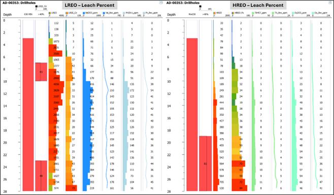
| Figure 10-5 | REE grade and leach % profile for drillhole AD-00353, representing a low percentage of intersection leaching |
Notes: Separate profiles for LREE-Ce and HREE. Column 1 – Intersection inside ≥630 ppm TREO grade shell (solid red), and average REO (ppm) grade where leach % >40% (black polygon). Column 2 – Percentage of Column A, where leach % >40%; therefore, for HREE, 36% of the drillhole samples inside the TREO envelope have leach % >40%. Column 3 – Average leach % of samples with leach % >40%. Column 4 – Leach % per sample. Column 5 – LREO grade profiles. Column 6 – HREO grade profiles.
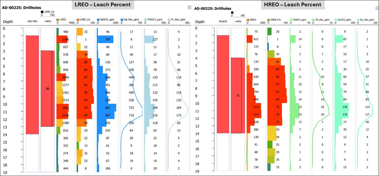
| Figure 10-6 | REE grade and leach % profile for drillhole AD-00225, representing a moderate percentage of intersection leaching but with high leach % |
Note: Refer to Figure 10-5 for footnotes.
| Page 50 |
| ITARANTIM REE PROJECT, BRAZIL, TECHNICAL REPORT SUMMARY | R257,2025 |
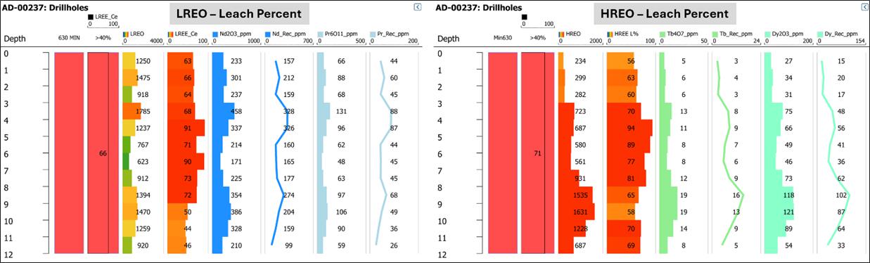
| Figure 10-7 | REE grade and leach % profile for drillhole AD-00237, representing a case of 100% of intersection leaching with high leach % |
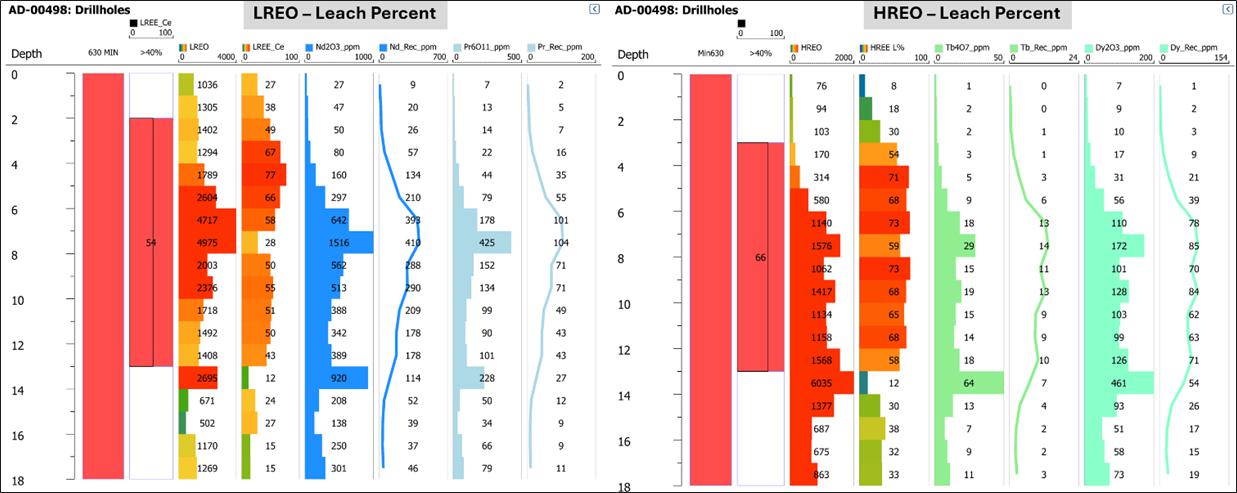
| Figure 10-8 | REE grade and leach % profile for drillhole AD-00498 for representation of moderate leach % and high grade from the recently drilled extension zone of Block B |
Note: Refer to Figure 10-5 for footnotes.
| 10.5 | Channel Sampling |
Three channel profiles were collected from a trench located in the eastern part of Block A (Figure 7-3). Sample intervals of 1 m were taken over channel sample lengths of between 3 m and 5 m for a total of 13 samples. The channel samples obtained an average leach % of 70% for both LREE and HREE, with a range between 55% and 84% for LREE and 56% and 85% for HREE (Table 10-4) (channel 2, Figure 10-9). Samples from channel 1 (3 m) and channel 3 (5 m) showed consistent results compared to channel 2.
These trench channel samples were specifically selected as representative of the various types and styles of REE mineralization at Itarantim.
| Table 10-4 | Summarized ranges of channel samples from Block A |
| LREE-Ce | HREE | ||||
| Average L % | Minimum L % | Maximum L % | Average L % | Minimum L % | Maximum L % |
| 70 | 55 | 84 | 70 | 56 | 85 |
| Page 51 |
| ITARANTIM REE PROJECT, BRAZIL, TECHNICAL REPORT SUMMARY | R257,2025 |
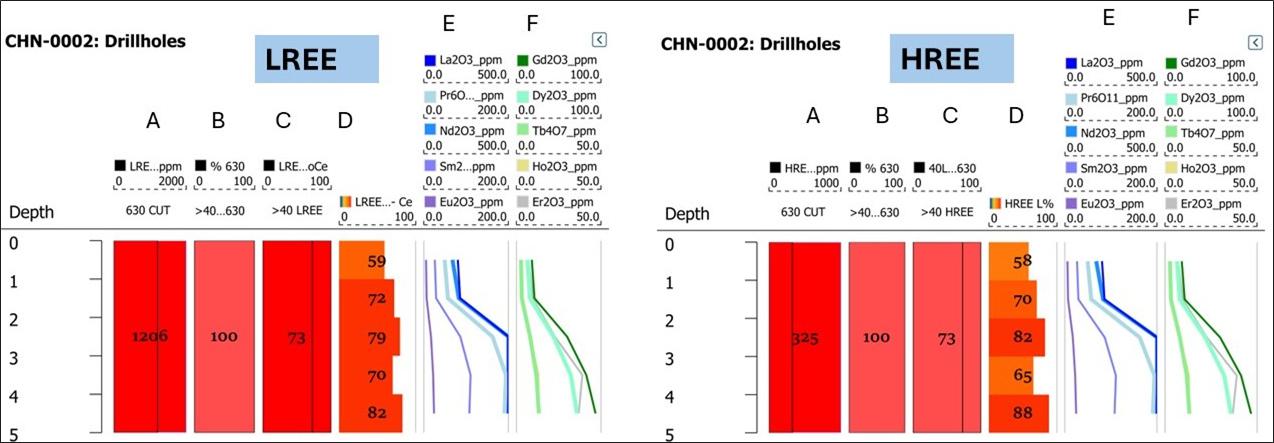
| Figure 10-9 | REE grade and leach % profile for channel 2 |
Note: Refer to footnotes for Figure 10-5 for explanation.
| 10.6 | Qualified Person Opinion and Recommendations |
ERM is of the opinion that the leach recovery data completed to date is adequate for the purposes of generating a MRE for the Project. However, additional petrological and recovery studies should be completed on the regolith material. The majority of gangue material in the samples consists of clay minerals such as kaolinite, iron oxides and hydroxides (largely goethite and hematite) as well as quartz and manganese oxides.
Petrographic studies focused on REE mineral deportment should be considered in the early stages of any exploration stage property. Due to the fine-grain size and omnipresent iron and manganese oxide phase of these deposits, standard petrography is of limited use. A Scanning Electron Microscope (SEM) study has been highlighted as of great importance for the study of the microcrystalline aggregates (Tassinari et al., 2001), as the crystal grains are commonly in the order of a few microns in diameter. These studies are relatively low-cost and are very informative. Additionally, the use of NIR for identifying both clay mineral phases and their crystallinity is a quick and effective method of identification.
These studies should be applied to all mineral extraction; however, it is vital that they are carried out as soon as possible, as they are of significant importance in REE mineral processing. It is imperative that the scheduled geometallurgy studies review both geological and metallurgical inputs (Woodall, 2007).
| Page 52 |
| ITARANTIM REE PROJECT, BRAZIL, TECHNICAL REPORT SUMMARY | R257,2025 |
| 11. | Mineral Resource Estimate |
| 11.1 | Data Import and Validation |
Drillhole data tables provided by IMC to ERM are presented in Table 11-1, and geological models presented in Table 11-2. After completing detailed data verification and due diligence checks of the drill hole database and reviewing the geological models, ERM takes full responsibility for the MRE presented in this Report.
| Table 11-1 | Drillhole database tables |
| IMC filename | Description | ERM filename | Datamine file |
| collar_ontopo.csv | Drillhole collars | Collar_1106.csv | Col.s |
| DHAssays.csv | Assays | DHAssays_1106.csv | Ass.s |
| Lithology.csv | Geological logs | Lithology_1106.csv | Lith.s |
| DHAssaysLeachRatio.csv | Leach results | DHAssaysLeachRatio_1106.csv | Leach.s |
| Table 11-2 | Geology model filenames |
| Leapfrog | Datamine (*tr/pt) | Description |
| Itarantim_250606.dtm | minz630_ | TREO envelope with lower TREO limit 630 ppm |
| Itarantim_250606_topoEx.dtm | Topo_2025_ | LiDAR surface as at April 2025 |
| Model 250618_flagged | It2506md | Resource model (with some domain and field names modified) |
Drillhole data were imported into Leapfrog, with validation tools provided by Leapfrog used to check for:
| ● | Absent collar data |
| ● | Multiple collar entries |
| ● | Overlapping intervals |
| ● | Negative sample lengths |
| ● | Sample intervals which extended beyond the hole depth defined in the collar table. |
The elemental assay fields were converted to oxides using an appropriate stoichiometric equation. IMC used the drillhole files for geological modeling and as a basis for grade interpolation.
ERM followed a similar process for importing the drillhole database tables into Datamine, with Datamine file “asslth.d” created, containing assay data. No errors were noted.
| 11.2 | Geological Modeling |
| 11.2.1 | Software |
Compilation and viewing of drilling, mapping, and sampling data in 2D utilized ArcGIS Pro. Modeling of geological and assay data in 3D utilized Leapfrog Geo version 2023.2.3.
Geostatistical analyses were conducted using Snowden Supervisor software and GeoAccess Professional. Due diligence reviews of the IMC Leapfrog resource model were completed by ERM using Datamine Studio RM (Datamine) software.
| Page 53 |
| ITARANTIM REE PROJECT, BRAZIL, TECHNICAL REPORT SUMMARY | R257,2025 |
| 11.2.2 | Preliminary Statistical Assessment |
Preliminary statistical analysis was undertaken on assay data to determine the cut-off to be used for modeling of the mineralization (TREO) envelope. Statistical analysis was undertaken utilizing TREO to ensure all REEs were captured within the mineralization envelope and estimated at the block model stage. A log histogram and probability plot of TREO indicated that a lower cut-off grade of 630 ppm TREO would be appropriate in delineating TREO mineralization boundaries (Figure 11-1). This is the same cut-off grade as was used to support the September 2024 historical estimate, and ERM still considers it reasonable to continue using the same cut-off grade for the current MRE.
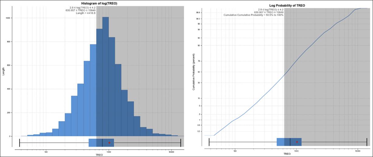
| Figure 11-1 | Histogram and log probability plots for TREO ppm utilized for preliminary statistical analysis of assay data |
| 11.2.3 | Lithology, Structure and Alteration |
As mineralization is hosted in the regolith, regolith domains were identified on the grounds of whole rock element (K2O, Na2O, Al2O3, CaO, MgO, Fe2O3 and MnO) and TREO geochemical profiles. Units defined within domains were identified as (1) Depleted Zone (2) Upper Transition Zone, (3) Enriched Zone, (4) Lower Transition Zone, and (5) Fresh Rock (Figure 11-2).
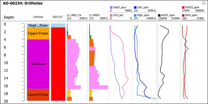
| Page 54 |
| ITARANTIM REE PROJECT, BRAZIL, TECHNICAL REPORT SUMMARY | R257,2025 |
| Figure 11-2 | Example of identified regolith units within the mineralized envelope |
Source: IMC, 2024
Subsequently, it was determined that the drillhole spacing and resolution of the block model did not support sub-domaining of the mineralized envelope and subsequent block model reporting per unit. As a result, the boundaries used for modeling were simplified into Hanging Wall (Depleted Zone), Min 630 (630 cut + Upper Transition Zone + Lower Transition Zone) and Footwall (Fresh) (refer Figure 11-3).
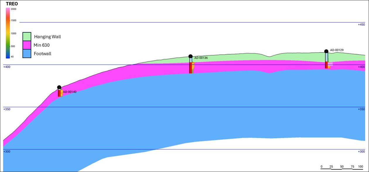
| Figure 11-3 | Representative cross-section of geological models showing mineralized envelope, hanging wall and footwall zones |
Source: IMC, 2024
There are no apparent structural associations associated with this regolith-hosted mineral system. It may be possible that structural relationships within the protolith exist, and which may have bearing on protolith mineralogy and subsequent saprolite grade; however, this is yet to be determined for the Project. Syn and post-mineralization processes that affect grade distribution and subsequent modeling are controlled by weathering, such as slumping and truncation of the regolith profiles through drainage development.
| 11.2.4 | Mineralization |
TREO composite lengths were generated utilizing 3 m intervals with a maximum included waste of 3 m and a 630 ppm TREO lower cut-off grade. Once composite intersections were generated, the top and bottom points of the 630 ppm TREO composite lengths were produced and utilized in generating the hanging wall and footwall boundaries of the mineralized envelope.
The footwall surface was either snapped to the end of hole, if 630 ppm mineralization persisted to the end of hole, or to the base of the 630 ppm cut interval if mineralization terminated prior to the end of hole. The topography was utilized as a reference surface to extrapolate between drillholes, defining the footwall geometry.
The hanging wall surface was defined by either the topography, if mineralization persisted to the top of hole, or to the top of 630 ppm cut interval if the mineralization is intersected lower than the top of the hole. The hanging wall domain effectively represents the Depleted Zone and was removed from the mineralization model and excluded from the estimation process.
The hanging wall and footwall surfaces were combined to produce a solid envelope representing the ≥630 ppm TREO population.
| 11.2.5 | Weathering |
Weathering has resulted in the IAC hosted deposit to be located within the regolith overlying an intrusive alkali granite of the Itarantim Complex. As a result, no specific weathering horizons are identified, nor modeled, nor are they relevant to modeling, for this style of deposit. The units within the saprolite zone of the regolith are of interest as these relate to grade and recovery. Closer infill drill spacing is required to interpret these stratigraphic internal domains.
| Page 55 |
| ITARANTIM REE PROJECT, BRAZIL, TECHNICAL REPORT SUMMARY | R257,2025 |
| 11.3 | Statistical and Geostatistical Analysis |
| 11.3.1 | Summary |
Statistical assessment of the input drill data was completed prior to grade estimation to understand the data grade distribution and populations. Drill sample data were statistically reviewed, and variograms were modeled to determine spatial continuity for all grade variables.
Statistical analyses were carried out using GeoAccess Professional and Snowden Supervisor software. ERM provided relevant results to IMC to enable them to carry out the grade interpolation. All statistical results were shared and discussed with IMC.
| 11.3.2 | Data Coding and Composite Length Analysis |
Datamine drillhole file “asslth.d” was flagged within the mineralization domain presented in Table 11-2 with the output Datamine file “assay.z” created.
Rare earths are grouped into HREO and LREO on the following basis:
| ● | LREO: La2O3, CeO2, Pr6O11, Nd2O3, Sm2O3, Eu2O3 |
| ● | HREO: Tb4O7, Dy2O3, Ho2O3, Er2O3, Tm2O3, Yb2O3, Lu2O3, Gd2O3; + Y2O3. |
A statistical analysis of sample lengths inside the mineralization domain was carried out to determine the appropriate composite length. All drillholes were sampled to lengths of 1 m and therefore 1 m was selected as the composite length.
| 11.4 | Statistical Analysis and Data Handling |
Statistical analyses were initially carried out for all REOs and other selected oxides using non-composited sample data, which was used to carry out final data verification, and for validation of the composited sample data. The statistical analyses presented in this section are from the composited and domained data within the ≥630 ppm TREO domain. Histograms and log probability plots were prepared and reviewed, which assisted with decision making on the combination of sample populations.
Statistical plots were generated by ERM in Microsoft Excel spreadsheets and relevant statistical plots are provided below.
When presenting statistical results for REO in ionic adsorption deposits, CeO2 is not included due to Ce3+ being easily oxidized by atmospheric oxygen (O2) to Ce4+ and the subsequent precipitation of the mineral cerianite (CeO2), which is not recoverable by ion-exchange leaching. Therefore, all leach testwork is presented as leach percentage quoted as TREE-Ce leach %, LREE-Ce leach %, and HREE leach %.
Composited sample data for TREO within the mineralized envelope are presented as a log histogram and as a normal histogram in Figure 11-4 and for LREO-CeO2 and HREO in Figure 11-5 and Figure 11-6. Histograms for other REOs, U3O8 and ThO2 were also generated.
The additional drilling supporting the MRE accounts for a 20% increase in the number of samples contained within the mineralization envelope, compared to earlier estimates. The location of the additional drilling is presented in Figure 7-6.
| Page 56 |
| ITARANTIM REE PROJECT, BRAZIL, TECHNICAL REPORT SUMMARY | R257,2025 |
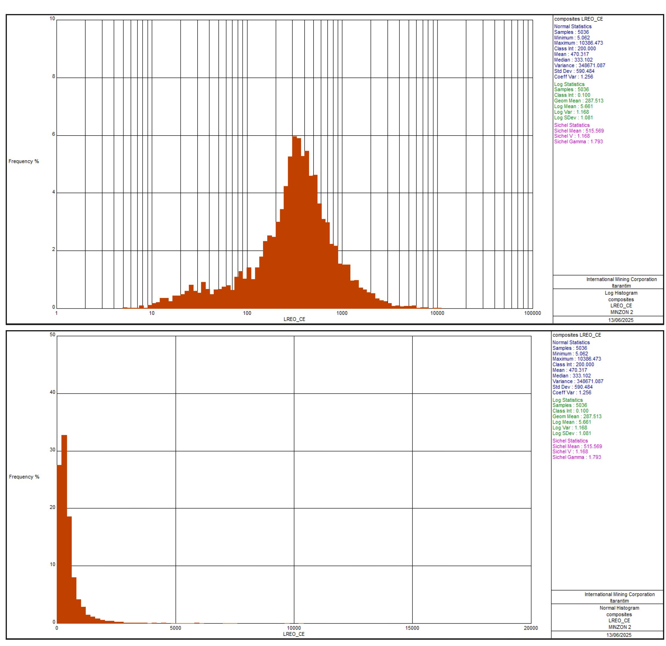
| Figure 11-4 | Log histogram (top) and normal histogram for TREO, from composited sample data in mineralization envelope |
| Page 57 |
| ITARANTIM REE PROJECT, BRAZIL, TECHNICAL REPORT SUMMARY | R257,2025 |
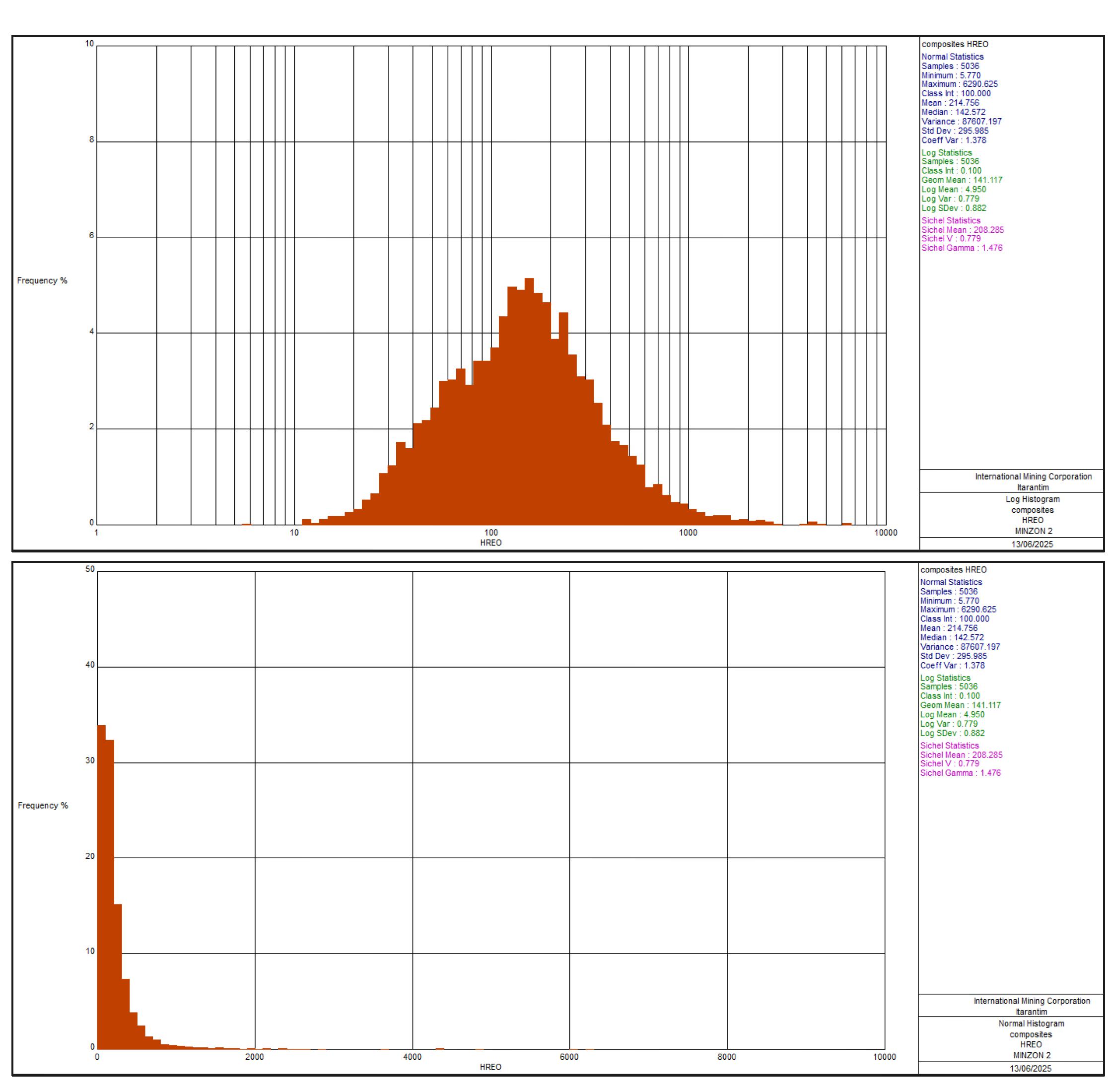
| Figure 11-5 | Log histogram (top) and normal histogram for LREO-CeO2, from composited sample data in mineralization envelope |
| Page 58 |
| ITARANTIM REE PROJECT, BRAZIL, TECHNICAL REPORT SUMMARY | R257,2025 |
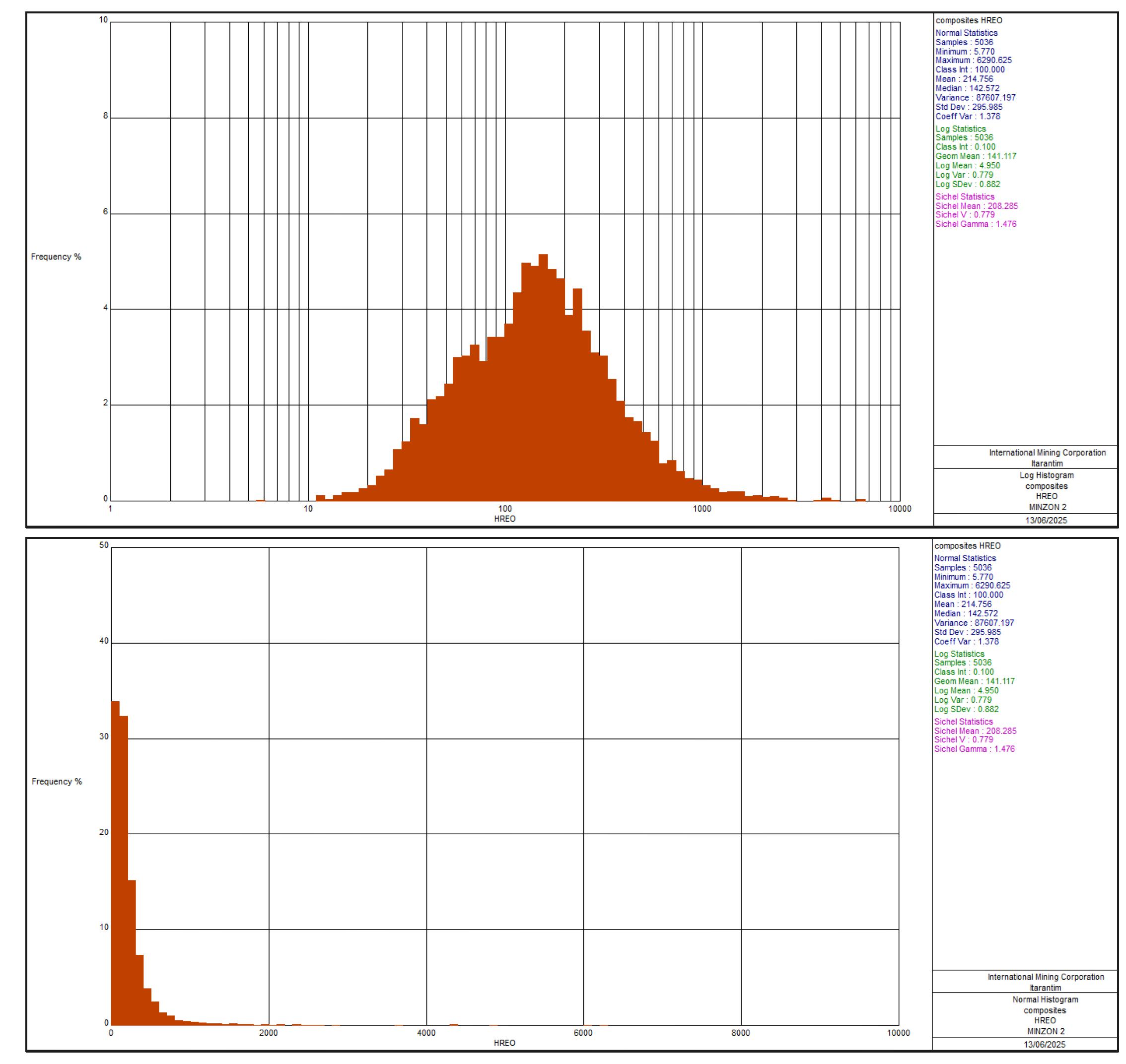
| Figure 11-6 | Log histogram (top) and normal histogram for HREO, from composited sample data in mineralization envelope |
| 11.4.1 | Treatment of Outliers |
A review of grade outliers was undertaken to ensure that extreme grades are treated appropriately during grade interpolation. Whilst grade outliers are real, they are potentially not representative of the volume they inform during estimation, and if not assessed appropriately they have the potential to result in significant grade overestimation on a local basis.
The decision to apply top cuts (grade capping) was based upon statistical analyses of composited sample populations. Log histograms of all domains were reviewed, and if deemed necessary, top cuts were chosen.
Top cuts for the affected oxides are presented in Table 11-3, with grades in ppm. The total number of samples within the ≥630 ppm TREO mineralization envelope is 5,036.
| Page 59 |
| ITARANTIM REE PROJECT, BRAZIL, TECHNICAL REPORT SUMMARY | R257,2025 |
| Table 11-3 | Grade capping summary |
| REO | Maximum grade | Top cut | Mean grade (cut) | No. samples cut |
| La2O3 | 5,279 | 3,100 | 207 | 3 |
| CeO2 | 12,403 | 10,000 | 578 | 1 |
| Pr6O11 | 1,063 | - | 49 | - |
| Nd2O3 | 4,326 | - | 177 | - |
| Sm2O3 | 739 | 500 | 32 | 2 |
| Eu2O3 | 83 | - | 5 | - |
| Gd2O3 | 514 | - | 26 | - |
| Tb4O7 | 94 | 50 | 4 | 7 |
| Dy2O3 | 605 | 300 | 23 | 7 |
| Ho2O3 | 129 | 60 | 4 | 7 |
| Er2O3 | 400 | 250 | 13 | 4 |
| Tm2O3 | 56 | 30 | 2 | 5 |
| Yb2O3 | 355 | 150 | 12 | 7 |
| Lu2O3 | 44 | - | 2 | - |
| Y2O3 | 4,407 | 2,500 | 128 | 7 |
| TREO | 14,032 | 12,000 | 1,263 | 4 |
| LREO | 13,685 | 12,000 | 1,049 | 1 |
| LREO-CeO2 | 10,386 | 7,000 | 469 | 6 |
| HREO | 6,291 | 3,000 | 212 | 7 |
| ThO2 | 404 | 200 | 30 | 2 |
| U3O8 | 348 | 80 | 8 | 4 |
Note: Summed REO grades (TREO, LREO, HREO) were not interpolated into the model, but were calculated from the individual REO grades. Therefore the top cuts for these were not utilized.
| 11.4.2 | Geostatistical Analysis kriging parameters and to guide |
Variography was completed to determine the choice of grade estimation search radii. Data were adjusted to normal scores prior to variography to assist with modeling the moderate to high positive skew sometimes displayed by the variables. Variograms were generated from 1 m top cut composited data.
Example variograms for Dy2O3 and Pr6O11 are presented in Figure 11-7 and Figure 11-8.
| Page 60 |
| ITARANTIM REE PROJECT, BRAZIL, TECHNICAL REPORT SUMMARY | R257,2025 |
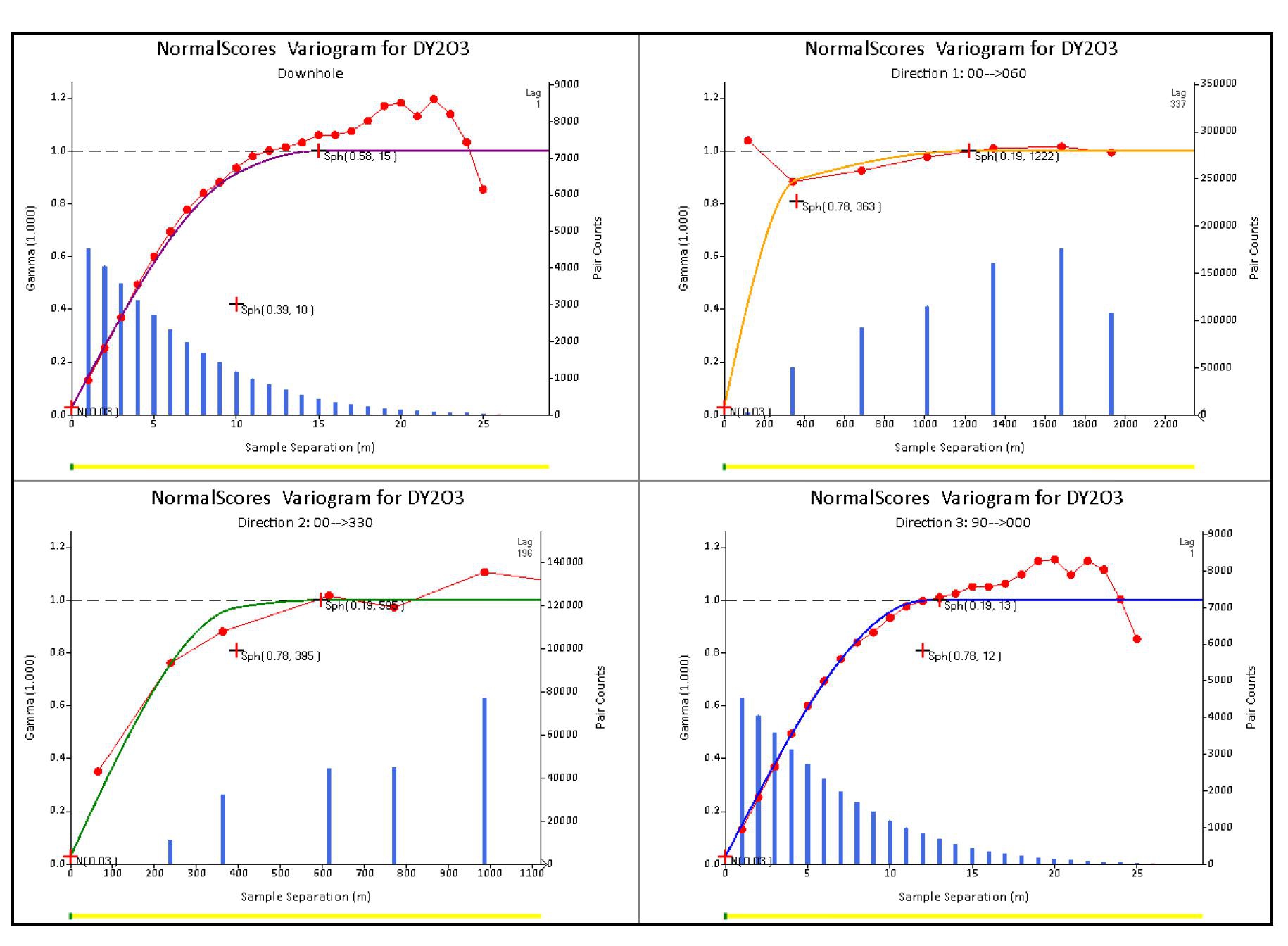
| Figure 11-7 | Normal scores variogram models, Dy2O3 |
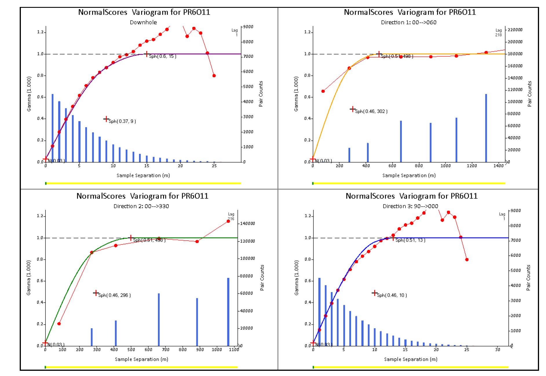
| Figure 11-8 | Variogram models, Pr6O11 |
| Page 61 |
| ITARANTIM REE PROJECT, BRAZIL, TECHNICAL REPORT SUMMARY | R257,2025 |
| 11.5 | Density |
Limited density measurements have been taken to date on the Project. A total of 59 samples were collected from ten sites in Blocks A and C and tested using the Standard Penetration Test (SPT) method. For SPP, a borehole must be drilled to the desired sampling depth. The test uses a thick-walled sample tube, with an outside diameter of 50.8 mm and an inside diameter of 35 mm, and a length of around 650 mm. The split-spoon sampler that is attached to the drill rod is placed at the testing point. A hammer of 63.5 kg is dropped repeatedly from a height of 76 cm driving the sampler into the ground until reaching a depth of 15 cm. The number of required blows is recorded. This procedure is repeated two more times until a total penetration of 45 cm is achieved. Samples were then sent to ALS for density determination using method GRA09as. This method does not require the sample to be oven dried but is coated in paraffin wax prior to weighing in a water bath. The density values are therefore regarded as “wet density”. Sample locations are presented in Figure 11-9.
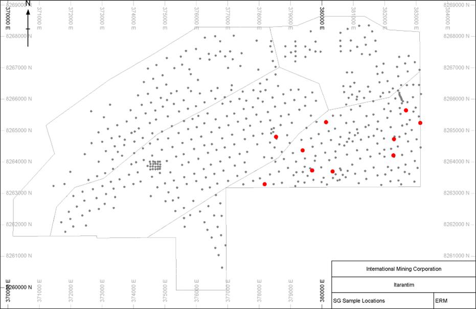
| Figure 11-9 | Specific gravity sample locations (red) and auger drill hole collars (grey) |
The average density of the 59 samples is 1.75 t/m3. Moisture content was not measured, and the density is assumed to be a wet density. The result was used to provide guidance for the choice of an appropriate density to assign to the resource model, assigned as 1.8 t/m3, which ERM considers to be appropriate for the host lithology. The QP author ERM recommends that IMC increase its efforts to obtain density data across the entire deposit, which can be derived from sampling methods such as diamond core drilling or trenching.
| Page 62 |
| ITARANTIM REE PROJECT, BRAZIL, TECHNICAL REPORT SUMMARY | R257,2025 |
For resource reporting, this average wet density was applied uniformly across the mineralized domain due to the shallow and homogeneous nature of the regolith. ERM recognizes that “dry density” values are preferred for tonnage estimation under S-K 1300. Accordingly, the use of wet density introduces a minor uncertainty that is not expected to materially affect tonnage at the current Inferred Resource classification level.
ERM recommends that future density programs determine dry bulk density through oven-drying of representative samples from all regolith units to support higher-confidence resource classifications and mine design studies.
| 11.6 | Block Modeling |
| 11.6.1 | Block Model Construction |
A block model was prepared for Itarantim using model limits and variables as presented in Table 11-4. The block model was created using Leapfrog software and imported into Datamine, which is regarded as the final version of the block model and is to be used for ongoing technical studies.
| Table 11-4 | Block model parameters and variables (grade variables are ppm) |
| Easting (X) | Northing (Y) | RL (Z) | |
| Itarantim Datamine filename “it2506md” | |||
| Origin | 370,000 | 8,259,900 | 170 |
| Extent (m) | 13,200 | 8,800 | 700 |
| Block size (sub-block) | 100 m (10 m) | 100 m (10 m) | 4 m (2 m) |
| Attributes | Description | ||
| MINZON | Hanging wall (=1), Mineralization domain 630 ppm (=2), Footwall domain (=3) | ||
| Block | Deposit block | ||
| Various REO | Estimated REO grade (ordinary kriging) (ppm) – La2O3, CeO2, Pr6O11, Nd2O3, Sm2O3, Eu2O3, Gd2O3, Dy2O3, Ho2O3, Er2O3, Tm2O3, Yb2O3, Lu2O3, Y2O3, Nb2O5 | ||
| TREO | Summed TREO grade (ordinary kriging) (ppm) – sum of all REO interpolated grades | ||
| HREO | Summed grade of the following REOs: Gd2O3, Tb4O7, Dy2O3, Ho2O3, Er2O3, Tm2O3, Yb2O3, Lu2O3, Y2O3 | ||
| LREO | Summed grade of the following REOs: La2O3, CeO2, Pr6O11, Nd2O3, Sm2O3, Eu2O3 | ||
| HMREO | Heavy magnet REO (DyTb) Dy2O3 + Tb4O7 | ||
| LMREO | Light magnet REO (NdPr) Pr6O11 + Nd2O3 | ||
| MREO | DyTb+ NdPr | ||
| TREO_CE | TREO – CeO2 | ||
| ThO2 | Estimated ThO2 (ordinary kriging) | ||
| U3O8 | Estimated U3O8 (ordinary kriging) | ||
| RESCAT | MRE classification: 3 = Inferred, 4 = Unclassified | ||
| DENSITY | Assigned density | ||
Parent block sizes were based upon approximately half to one-third of the typical drill spacing. Sub-blocks were used to allow the blocking process to adequately fill the domain volumes. The block model was not rotated.
| Page 63 |
| ITARANTIM REE PROJECT, BRAZIL, TECHNICAL REPORT SUMMARY | R257,2025 |
| 11.6.2 | Grade Interpolation |
Top cut composited samples were used to interpolate the grade variables (listed in Table 11-4) into the block model using ordinary kriging. Grades were interpolated into the ≥630 ppm mineralization domain defined as MINZON 2 in the block model.
A search ellipse of 1,000 m(X) by 1,000 m(Y) by 600 m(Z) was used to select samples for grade interpolation, with a minimum of 8 and a maximum of 16 samples used per block estimate. A maximum of 4 samples per drillhole were permitted for each block estimate. Grades were interpolated into the parent cell and the grades assigned to all sub-cells.
| 11.7 | Block Model Validation |
Validation of the block model and grade estimates was completed by:
| ● | Visual checks on screen in cross-section and plan view to ensure that block model grades honor the grade of sample composited grades |
| ● | Statistical comparison of sample and block grades |
| ● | Generation of swath plots to compare input and output grades in a semi-local sense, by easting, northing and elevation |
| ● | Check for negative or absent block grades. |
| 11.7.1 | Visual Validation |
The block model was reviewed by stepping through cross-sections, ensuring that estimated REO grades were consistent with the surrounding drillhole sample grades.
| 11.7.2 | Statistical Validation |
Mean block grades for selected domains were compared to the mean sample grades. Naïve average sample grades for selected top cut and composited samples for the mineralization domain were used and compared.
Validation results showed the mean block grades compared favorably with the mean sample grades. Table 11-5 shows results for selected REOs.
| Table 11-5 | Model, naïve grades (ppm) |
| Data | Tb4O7 | Dy2O3 | Pr6O11 | Nd2O3 | ThO2 |
| Block model | 3.87 | 21.6 | 45.1 | 161.4 | 33.2 |
| Naïve composites | 4.00 | 23.1 | 49.1 | 176.8 | 29.9 |
Swath plots compare the trend of average grades of the model and input sample data, along a specified direction. Figure 11-10 to Figure 11-12 present swath plots for Pr6O11, Dy2O3 and CeO2 within the ≥630 ppm TREO mineralization domain. These demonstrate some smoothing of the interpolated block grades compared to the input sample data, which is to be expected by ordinary kriging methodology, however, the sample data trends can still be observed in the block grade distribution. Of interest is the reversed trends of Pr6O11 and Dy2O3, compared to CeO2, by elevation of the sample and block centroid.
| Page 64 |
| ITARANTIM REE PROJECT, BRAZIL, TECHNICAL REPORT SUMMARY | R257,2025 |
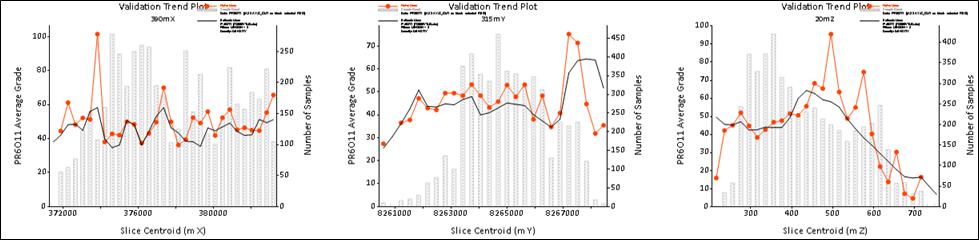
| Figure 11-10 | Swath plots, Pr6O11 |
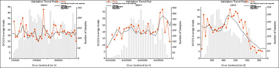
| Figure 11-11 | Swath plots, Dy2O3 |
| Figure 11-12 | Swath plots, CeO2 |
| 11.8 | Mineral Resource Reporting |
| 11.8.1 | Initial Assessment and Reasonable Prospects for Economic Extraction |
ERM has completed an Initial Assessment and believes there are RPEE of the MRE due to the deposit demonstrating sufficient grade, quantity and continuity to support RPEE. Additionally, the deposit is supported by nearby infrastructure including: (1) close proximity to large population centers; (2) located within 150 km of a planned maritime port facility at Ilheus and 350 km from the port at Salvado; and (3) and close to power and water infrastructure.
The leachability of the rare earth mineralization from the clay host minerals is favorable for extraction by either in-situ leaching or open pit mining, followed by heap leaching or alternative extraction methods. Leachability and recovery work, completed by IMC, that supports this is detailed in Sections 10.2 to 10.5.
Cut-off Grade Determination
A cut-off grade of >650 ppm TREO has been selected and determined to be appropriate for reporting the Inferred MRE and meeting RPEE (refer Figure 11-14).
The cut-off grade, referred to here as the marginal cut-off grade, has been derived as the optimal grade where revenue from processing one tonne of already-mined material equals the processing cost. A marginal cut-off grade was determined using a revenue-to-cost methodology based on a full rare earth oxide (REO) basket, determined using individual element grades, metallurgical recoveries, and commodity prices (in USD as of March31, 2025) as presented in Table 11-6, and the reasonable assumptions, based on an assumed open-pit mining method, as summarized in Table 11-7.
The commodity prices were selected based on each REE oxide pertinent to the Project sourced from the Shanghai Metals Market (SMM), a leading global provider of nonferrous and ferrous metal prices analysis and consensus reference, and assuming a six month trailing average for REE prices. The QP considers that while the commodity prices may be considered conservative they are also considered realistic to apply to an Inferred Mineral resource at this stage of the Project assessment. Also that the prices are similar to the prices used by similar REE operations.
| Page 65 |
| ITARANTIM REE PROJECT, BRAZIL, TECHNICAL REPORT SUMMARY | R257,2025 |
| Table 11-6 | REE commodity prices in USD used for Initial Assessment of Itarantim Inferred Mineral Resource, cut-off grade TREO >650 ppm, pricing effective March 31, 2025 |
| Commodity (REE oxide) | Unit | Value | % REE Oxide | Recovery % |
| La2O3 | USD/t | 640 | 15.6 | 52 |
| CeO2 | USD/t | 1,742 | 47.9 | 10 |
| Pr6O11 | USD/t | 64,000 | 3.7 | 55 |
| Nd2O3 | USD/t | 68,922 | 13.3 | 58 |
| Sm2O3 | USD/t | 2,100 | 2.4 | 55 |
| Eu2O3 | USD/t | 24,751 | 0.4 | 55 |
| Gd2O3 | USD/t | 24,200 | 2.0 | 57 |
| Tb4O7 | USD/t | 1,032,453 | 0.3 | 52 |
| Dy2O3 | USD/t | 229,315 | 1.8 | 55 |
| Ho2O3 | USD/t | 69,080 | 0.4 | 53 |
| Er2O3 | USD/t | 48,560 | 1.0 | 55 |
| Tm2O3 | USD/t | 200 | 0.2 | 50 |
| Yb2O3 | USD/t | 12,800 | 0.9 | 48 |
| Y2O3 | USD/t | 8,000 | 10.0 | 61 |
| Lu2O3 | USD/t | 730,000 | 0.1 | 46 |
Notes:
| ● | Commodity price assumptions effective as at March 31, 2025. |
| ● | Source of commodity pricing – Shanghai Metals Market (SMM) - https://www.metal.com/Rare-Earth-Oxides |
| Table 11-7 | Economic parameter assumptions used for Initial Assessment of Itarantim Inferred Mineral Resource, cut-off grade TREO >650 ppm effective March 31, 2025 |
| Parameter | Unit | Value |
| Metal prices | USD/t | As per Table 11-6 |
| Mining recovery | % | 90 |
| Processing recovery HREO | % | 28–71 |
| Processing recovery LREO | % | 23–58 |
| Payability | % | 80 |
| Mining cost | USD/t rock | 2.10 |
| Processing cost | USD/t feed | 9.50 |
| Bulk density (wet) | t/m3 | 1.8 |
| G&A cost | USD/t feed | 0.90 |
Note: Assumptions effective as at March 31, 2025.
The marginal (processing-based) cut-off approach was adopted because it reflects a strategy focused on optimizing processing activities within a laterally continuous, near-surface ionic clay mineralized system. The deposit comprises near-surface, laterally continuous ionic clay mineralisation with minimal stripping required, no drilling or blasting requirement, and limited variability in mining conditions, resulting in effectively uniform mining costs across mineralised material. As such, the key economic decision is whether material is prioritized for processing or scheduled for later treatment, making processing cost the key controlling variable.
A marginal (processing-based) cut-off is therefore applied, consistent with industry practice for similar deposits and aligned with a strategy of optimizing processing activities and processing plant utilization. This allows for lower-grade material to be deferred and processed under improved operating conditions or during periods of stronger pricing, particularly given the potential for short-term price increases in magnet rare earth markets.
Mining costs are not included in the cut-off grade determination, as they are: low in cost; consistent with near surface ionic adsorbed clay (IAC) style of rare earth deposits; do not form the primary economic discriminator within the mineralised horizon; and do not materially influence processing decisions within the mineralised domain. Whilst mining costs are implicitly captured in the overall economic framework it is not appropriate to use them as the controlling parameter for cut-off grade determination for this style of mineralization.
A processing-based approach was applied to the element grades, metallurgical recoveries, and commodity prices, to determine a value of revenue per tonne of mineralized material using the following formula:
Revenue (USD/t mineralized material) = Σ [(Gradeᵢ (ppm) / 1,000,000) × Recoveryᵢ × Priceᵢ]
The total assumed revenue per tonne of mineralized material, based on the weighted average resource composition and pricing assumptions (Table 11-8), corresponds to an estimated basket value of approximately USD 0.012–0.013 per ppm TREO. The basket case is a Value per ppm, and is a determination by the formula below:
Total revenue per tonne of mineralized material / TREO ppm (15.38 / 1,233 = 0.0125)
The marginal (processing-based) cut-off grade is then defined as the grade at which processing cost are covered and derived using the following formula:
Cut-off grade (ppm) = Processing Cost (USD/t) / Value per ppm (USD/ppm)
Using the calculated total revenue per tonne of mineralized material and corresponding Value per ppm, processing costs were evaluated over a range of USD 8.2/t to USD 9.5/t. Applying the above relationship results in the following marginal (processing-based) cut-off range of:
Cut-off grade of 650 ppm TREO at USD 8.2/t (Cut-off (ppm) = 8.2/0.0125
Cut-off grade of 750 ppm TREO at USD 9.5/t (Cut-off (ppm) = 9.5/0.0125
The cut-off grades are rounded to the nearest 50 ppm TREO. Further details are provided in Table 11-9.
| Page 66 |
| ITARANTIM REE PROJECT, BRAZIL, TECHNICAL REPORT SUMMARY | R257,2025 |
This defines a reasonable operating range for processing decisions and supports the selection of a cut-off grade within this range. A cut-off grade of 650 ppm TREO was selected, representing the lower bound of the evaluated range and aligning with a strategy of maximizing the recoverable resource while maintaining efficient processing through selective scheduling of mined ore.
The lower processing cost assumption is supported by favourable ionic clay metallurgy, including low reagent consumption and ambient leaching conditions, as well as benchmarking against comparable operations.
The REO basket is weighted toward magnet rare earths (notably Nd, Pr, Dy and Tb), which are associated with strong long-term demand fundamentals. While the cut-off is based on current price assumptions, the potential for improved pricing conditions supports the selection of a lower cut-off within the evaluated range as part of an optimisation-driven operating strategy.
The QP compared the 650 ppm TREO cut-off grade with the grade tonnage table (Figure 11-14) and determined that a TREO cut-off grade of >650 ppm was reasonable for reporting the MRE, and reflects the physical characteristics of the deposit, realistic operating assumptions, and a processing-led optimisation strategy.
Table 11-8 Calculated assumed revenue per tonne of mineralized material
| Commodity (REE oxide) | Grade (ppm) | Recovery (%) | Price (USD/t) | Assumed Revenue ($/t mineralized material) |
| La2O3 | 192 | 0.52 | 640 | 0.06 |
| CeO2 | 590 | 0.1 | 1,742 | 0.10 |
| Pr6O11 | 46 | 0.55 | 64,000 | 1.61 |
| Nd2O3 | 164 | 0.58 | 68,922 | 6.56 |
| Sm2O3 | 30 | 0.55 | 2,100 | 0.03 |
| Eu2O3 | 5 | 0.55 | 24,751 | 0.07 |
| Gd2O3 | 24 | 0.57 | 24,200 | 0.33 |
| Tb4O7 | 4 | 0.52 | 1,032,453 | 2.11 |
| Dy2O3 | 22 | 0.55 | 229,315 | 2.76 |
| Ho2O3 | 4 | 0.53 | 69,080 | 0.16 |
| Er2O3 | 12 | 0.55 | 48,560 | 0.33 |
| Tm2O3 | 2 | 0.5 | 200 | 0.00 |
| Yb2O3 | 12 | 0.48 | 12,800 | 0.07 |
| Y2O3 | 123 | 0.61 | 8,000 | 0.60 |
| Lu2O3 | 2 | 0.46 | 730,000 | 0.57 |
| TREO | 1,233 | |||
| Total Assumed Revenue ($/t mineralized material) | 15.38 | |||
Note:
Revenue ($/tonne of mineralized material) = (Grade (ppm)/1,000,000) * Recovery % * Price
Table 11-9 Ranges for determination of marginal cut-off grade
| Costs | High | Low |
| Mining Cost ($/t) | 2.1 | 1.9 |
| Processing Cost ($/t) | 9.5 | 8.2 |
| G&A Cost ($/t) | 0.9 | 0.5 |
| Total Cost ($/t) | 12.5 | 10.6 |
| Marginal Cut-off grade (ppm) | 761 | 657 |
Notes:
Total Assumed Revenue ($/t mineralized material) = 15.38
Total grade (TREO ppm) = 1233
Value per TREO ppm ($/ppm) = 0.0125
The QP considered the lower confidence level for the estimated rare earth grades for an Inferred MRE, as discussed in Section 11.8.2, and also considered a range of grades within a reasonable tolerance limit when selecting the marginal cut-off grade. The calculated value was then compared with the grade tonnage table (Figure 11-14) and the QP determined that a TREO cut-off grade of >650 ppm was reasonable for reporting the MRE.
| 11.8.2 | Mineral Resource Estimate Classification |
The MRE has been prepared and reported in accordance with Item 1300 of Regulation S-K (Subpart 229.1300) under the United States SEC. The Mineral Resource category of Inferred Mineral Resource used in this Report follows the definitions set out in §229.1300 Definitions. The estimation methodology and classification criteria have been reviewed by ERM and are consistent with the requirements of S-K 1300, including the criteria set forth in §229.1302(d)(1). The MRE classification is based upon an assessment of geological understanding of the deposit, geological and grade continuity, drillhole spacing, quality control results, search and interpolation parameters, and an analysis of available density information. Mineral Resources are not Mineral Reserves and do not have demonstrated economic viability. There is no certainty that all or any part of an Inferred Mineral Resource will be converted into Indicated or Measured Mineral Resource or that Mineral Resources will be converted into Mineral Reserves.
Confidence in the estimate of Inferred Mineral Resources is not sufficient to allow the results of the application of any technical and economic parameters to be used for detailed mine planning as part of pre-feasibility or feasibility studies.
| Page 67 |
| ITARANTIM REE PROJECT, BRAZIL, TECHNICAL REPORT SUMMARY | R257,2025 |
The Inferred Mineral Resource has not been significantly extrapolated beyond the limits of the drillholes. Volumes of the block model located outside IMC tenure are not classified. Figure 11-13 shows a drillhole location plan of the deposit with the mineralization domain shown. A discussion of the blocks shown in Figure 11-13 is presented in Section 7.1.2.
ERM notes that the Project is an early-stage exploration stage project and that Inferred Mineral Resource estimates have significant geological uncertainty as they are based on limited geological evidence and sampling. Sources of uncertainty for the Inferred Mineral Resource estimates reported in this Report include: sampling and drilling methods, data processing and handling, geologic modeling and estimation. The Inferred Mineral Resource estimates may also be impacted by further infill and exploration drilling that may result in an increase or decrease in future resource evaluations. The Inferred Mineral Resource estimates may also be affected by subsequent assessment of mining, environmental, processing, permitting, taxation, socio-economic and other factors. Such factors may include: changes to commodity price and exchange rate assumptions; changes to the assumptions used to generate a cut-off grade for TREO of >650 ppm; changes in local interpretations of mineralization geometry and continuity of mineralized zones; changes to geological and mineralization shape and geological and grade continuity assumptions; density and domain assignments; changes to geotechnical, extraction, processing and production assumptions; changes to the input and design parameter assumptions that pertain to mining design; assumptions as to the continued ability to access the site, retain mineral and surface rights titles, maintain environment and other regulatory permits and maintain the social license to operate.
IMC intends to continue exploration activities including: infill drilling, further resource definition drilling, detailed density testwork, early stage geotechnical and hydrogeological assessments, ongoing detailed metallurgical testwork, baseline environmental studies, and initial economic assessment of mining options. ERM is of the opinion that this additional work will enable an increased confidence in classification of future MREs and will contribute to increased precision in the RPEE criteria in the future. ERM is of the opinion that any issues relating to the relevant technical and economic factors likely to influence the prospect of economic extraction can be resolved with further work.
| Page 68 |
| ITARANTIM REE PROJECT, BRAZIL, TECHNICAL REPORT SUMMARY | R257,2025 |
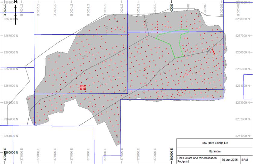
| Figure 11-13 | Drillhole collar plan, showing drillhole collars (red), TREO mineralization domain (grey), tenure (blue), “blocks” (grey), and region of unclassified resources (dashed green polygon) |
Note: All TREO domains are classified as Inferred, except for edges outside tenure and the unclassified resource in the northeast area (cyan).
| 11.8.3 | Mineral Resource Estimate Statement |
The MRE is classified as an Inferred Mineral Resources (refer Section 11.8.2) and is presented in Table 11-8 and reported above a cut-off grade of 650 ppm total rare earth oxides (TREO). The MRE has an effective date of March 31, 2025. The MRE includes reporting of “heavy rare earth oxides” (HREO), “light rare earth oxides” (LREO), “magnet rare earth oxides” (MREO), “heavy MREO” (DyTb), “light MREO” (NdPr), individual magnet rare earth oxides (Tb4O7,DY2O3, PR6O11, ND2O3, and deleterious oxides U3O8 and ThO2. The MRE is reported by block region, as discussed in Section 7.1.2.
The MRE is reported on an in-situ basis, representing the estimated tonnes and grades (ppm TREO) in the ground and prior to the application of any modifying factors. The resource is constrained a by mineralised envelope defined at a statistical threshold of approximately 630 ppm TREO, which distinguishes mineralised material from surrounding lower-grade zones.
No adjustments have been made to the reported Mineral Resource for mining recovery, dilution, metallurgical recovery, payability, or other economic modifying factors. These factors have been considered separately to support reasonable prospects for eventual economic extraction, including the derivation of the cut-off grade, but have not been applied to the reported resource.
Accordingly, the Mineral Resource is reported on an in-situ basis in compliance with Item 1304(d)(1) of Regulation S-K.
A grade-tonnage graph showing the reported tonnage and grades above incrementally increasing TREO cut-off grades is presented in Figure 11-14, note that the base case for the MRE is TREO >650 ppm (red line denotes TREO 650 ppm - this COG shows the optimal tonnage at the best grade for TREO).
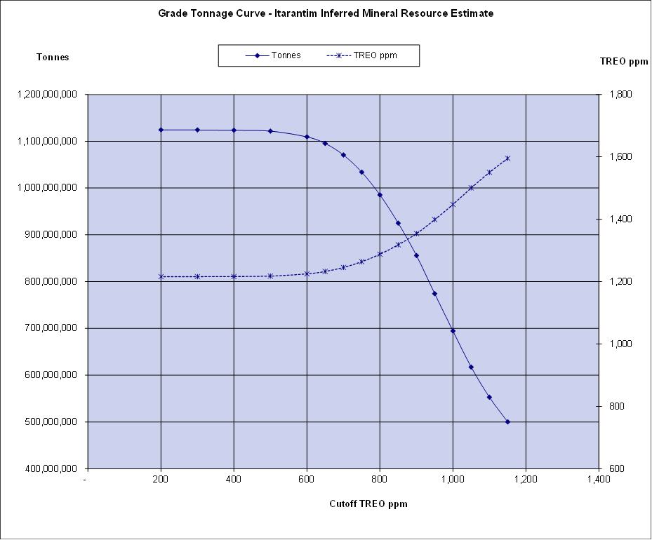
| Figure 11-14 | Grade-tonnage table by TREO cut-off grades (base case for MRE reporting is TREO >650 ppm) |
| Page 69 |
| ITARANTIM REE PROJECT, BRAZIL, TECHNICAL REPORT SUMMARY | R257,2025 |
| Table 11-8 | Itarantim Inferred Mineral Resource with cut-off grade of TREO >650 ppm - effective March 31, 2025 |
| Mineral Resource Estimate | Block | Tonnes (Mt) | TREO (ppm) | Contained TREO (Mt) | LREO (ppm) | HREO (ppm) | MREO (ppm) | Ratio MREO:TREO | NdPr (ppm) | DyTb (ppm) | Tb4O7 (ppm) |
Dy2O3 (ppm) |
Pr6O11 (ppm) |
Nd2O3 (ppm) |
U3O8 (ppm) |
ThO2 (ppm) |
| Inferred | A | 190 | 1,148 | 0.223 | 951 | 198 | 239 | 0.21 | 214 | 25 | 4 | 21 | 47 | 168 | 6 | 24 |
| B | 120 | 1,170 | 0.143 | 941 | 228 | 237 | 0.20 | 209 | 28 | 4 | 24 | 46 | 163 | 8 | 38 | |
| C | 330 | 1,127 | 0.372 | 934 | 193 | 216 | 0.19 | 191 | 24 | 4 | 21 | 42 | 150 | 8 | 33 | |
| D | 410 | 1,390 | 0.574 | 1,175 | 216 | 251 | 0.18 | 224 | 27 | 4 | 23 | 49 | 175 | 10 | 37 | |
| E | 40 | 1,057 | 0.038 | 898 | 159 | 222 | 0.21 | 202 | 21 | 3 | 17 | 43 | 159 | 5 | 18 | |
| Total Inferred Resources | 1,100 | 1,233 | 1.350 | 1,027 | 205 | 236 | 0.19 | 210 | 26 | 4 | 22 | 46 | 164 | 8 | 33 | |
Notes to accompany MRE table:
| ● | Mineral resources are reported using definitions set out in Regulation S-K 1300 and are current as of March 31, 2025. |
| ● | The third-party firm responsible for the MRE is ERM. |
| ● | Mineral resources are reported at a cut-off grade above 650 ppm TREO. Key assumptions used in the MRE and to meet RPEE are indicated in Table 11-7 above. |
| ● | The point of reference for the MRE is in situ. |
| ● | Mineral resources have been rounded and due to effects of rounding, the total may not represent the sum of all components. |
| ● | Mineral Resource is only reported from blocks within the permit areas. |
| ● | LREO = La2O3, CeO2, Pr6O11, Nd2O3, Sm2O3, Eu2O3. |
| ● | HREO = Gd2O3, Tb4O7, Dy2O3, Ho2O3, Er2O3, Tm2O3, Yb2O3, Lu2O3, Y2O3. |
| ● | TREO = LREO + HREO. |
| ● | Contained TREO (MT) = (Tonnes * TREO (converted to percent))/1,000,000 |
| ● | Ratio MREO:TREO = MREO / TREO |
| ● | DyTb = Tb4O7 + Dy2O3, being the sum of the heavy magnetic rare earth oxides |
| ● | NdPr = Pr6O11 + Nd2O3, being the sum of the light magnetic rare earth oxides |
| ● | MREO = DyTb + NdPr. |
| ● | Density of 1.8 t/m3 applied to all blocks in mineralization zone. Density is a wet density. |
| Page 70 |
| ITARANTIM REE PROJECT, BRAZIL, TECHNICAL REPORT SUMMARY | R257,2025 |
The MRE is also reported above a cut-off grade of 400 ppm total magnetic rare earth oxides (MREO). A grade-tonnage graph above incrementally increasing MREO cut-off grades is presented in Figure 11-15, note that the base case for the MRE is MREO >400 ppm.
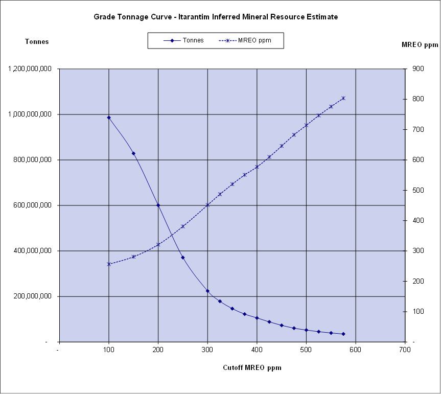
| Figure 11-15 | Grade tonnage table by MREO cut-off grades (base case for MRE reporting is MREO >400 ppm) |
The leachability of the Itarantim ionic adsorption deposit is presented in Table 11-9. Figure 11-16 presents a typical profile of a drillhole showing the vertical variability of REO grades and corresponding leach % and should be used to provide guidance for understanding Table 11-9. Other examples are presented in Section 10.4.
| Page 71 |
| ITARANTIM REE PROJECT, BRAZIL, TECHNICAL REPORT SUMMARY | R257,2025 |
| Table 11-9 | Summary of leach results, Itarantim |
| LREE-Ce | HREE | ||||
| Average L % | Minimum L % | Maximum L % | Average L % | Minimum L % | Maximum L % |
| 55 | 40 | 80 | 58 | 41 | 77 |
Notes:
| ● | All leach results from samples contained within the ≥630 ppm TREO grade shell, and where leach % >40%. |
| ● | Results are for elemental rare earths, not oxides. |
| ● | LREE-Ce = total light rare earth elements minus Ce. |
| ● | HREE = total heavy rare earth elements. |
| ● | Leach % = leach (ppm) / REE (ppm). |
| ● | Total number of tests supporting Table 11-9; HREE (89), LREE-Ce (103). |
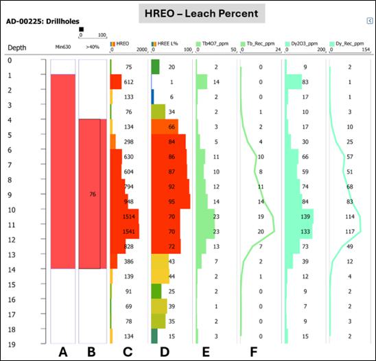
| Figure 11-16 | REE grade and leach % profile for drillhole AD-00225 |
Notes: Separate profiles for LREE-Ce and HREE. Column A – ≥630 ppm TREO grade shell (solid red). Column B – Leach % >40 interval and average leach percent annotated. Column C – Element grade profile. Column D – Leach % profile. Column E – Element grade. Column F – Element Recovered (grade x leach percent).
| Page 72 |
| ITARANTIM REE PROJECT, BRAZIL, TECHNICAL REPORT SUMMARY | R257,2025 |
| 12. | Mineral Reserve EstimateS |
Not applicable to this TRS.
| 13. | Mining Methods |
Not applicable to this TRS.
| 14. | Processing and Recovery Methods |
Not applicable to this TRS.
| 15. | Infrastructure |
Not applicable to this TRS.
| 16. | Market Studies |
Not applicable to this TRS.
| 17. | Environmental Studies, Permitting, and Plans, Negotiations, or Agreements with Local Individuals or Groups |
Not applicable to this TRS.
| 18. | Capital and Operating Costs |
Not applicable to this TRS.
| 19. | Economic Analysis |
Not applicable to this TRS.
| 20. | Adjacent Properties |
There are no adjacent properties to the Project.
| 21. | Other Relevant Data and Information |
No additional information or explanation is necessary to provide a complete and balanced presentation of the value of the Project to the Registrant.
| Page 73 |
| ITARANTIM REE PROJECT, BRAZIL, TECHNICAL REPORT SUMMARY | R257,2025 |
| 22. | Interpretation and Conclusions |
The Itarantim REE Ionic Adsorption Project represents an early-stage exploration stage property in the Bahia State located in northeast Brazil. The Project is a new REE discovery and has had moderate to intensive exploration activities (including geophysics, geological mapping, surface geochemistry and auger drilling) conducted by IMC over the past four years.
An Inferred MRE is supported by drilling completed by IMC. The Project contains REE mineralization with 60–90% of the REEs physically adsorbed onto clay minerals, notably kaolinite and halloysite. These REEs can be recovered by using simple inorganic salt solutions whereby during the leaching process, the REEs are readily transferred into solution as soluble sulfates or chlorides, depending upon the lixiviant used.
ERM considers that data collection techniques are consistent with current industry best practice and suitable for use in the preparation of a Mineral Resource to be reported in accordance with S-K 1300. QAQC sampling and results supports the integrity of the data which has been used to prepare the current MRE.
A 3D wireframe model representing TREO mineralization (TREO ≥630 ppm) is based upon geological logs and geochemical analyses of drillhole samples. Machine augered drillhole samples were used to interpolate grades into blocks using ordinary kriging. Several methods were used to validate the block model, including visual review and comparison of sampling and block model grades.
The MRE was classified as Inferred Mineral Resources and is reported above a cut-off grade of 650 ppm TREO. Global leachability results support the reporting of an ionic adsorption Mineral Resource. The QP has determined that the cut-off >650 ppm TREO to be appropriate for reporting the Inferred Mineral Resource and meeting RPEE.
ERM has completed an Initial Assessment and is of the opinion that the Inferred Mineral Resource classification is appropriate based on the informing data and underlying understanding of the mineralization of the deposit at this stage of the Project. Furthermore, ERM is of the opinion that deposit is of sufficient grade, quantity and coherence to meet RPEE at this stage of the Project development. Further work is required, in particular infill drilling at a closer drill spacing, to enable detailed interpretation of internal stratigraphic domaining of the mineralization to inform mine studies for economic evaluation.
ERM is of the opinion that the exploration potential for the Itarantim Project is high. The combination of favorable regional geological location, highly prospective local geology and potential structural framework, an active geomorphology, favorable and coincident geochemical and geophysical anomalies, and successful drill results to date, confirm the prospectivity of the area for discovery of further REE mineralization.
| 22.1 | Material Risks and Uncertainties |
In the opinion of ERM, the Itarantim REE Project represents an early-stage exploration stage property with no known fatal flaws. The Project exhibits favorable geological setting, mineralization style, and jurisdictional characteristics that support RPEE.
However, as typical for projects at the Initial Assessment stage, certain technical, environmental, permitting, and market uncertainties remain. These uncertainties are not considered to materially affect ERM’s overall conclusions but could influence the timing, cost, or ultimate development pathway for the Project. The principal risks and corresponding mitigation measures are summarized below.
| Page 74 |
| ITARANTIM REE PROJECT, BRAZIL, TECHNICAL REPORT SUMMARY | R257,2025 |
| Table 22-1 | Principal risks and mitigation strategies for the Itarantim REE Project |
| Risk category | Description of risk/uncertainty | Potential impact | Proposed mitigation / ERM comment |
| Geological and Resource | The current MRE is based on auger drilling at moderate spacing with limited dry-density data. Geological and grade continuity within the regolith may not be fully constrained. | Possible tonnage or grade adjustments with additional data; may affect resource classification confidence. | Conduct infill drilling (90 m x 80 m grid), twin auger holes with sonic/diamond drilling, and obtain dry-density measurements to replace wet density values. |
| Metallurgical/ Processing | Leachability and recovery assumptions rely on laboratory-scale testwork; pilot or industrial-scale performance unverified. | May affect recovery rates and operating cost estimates. | Continue leach and variability testing; advance to pilot-scale column or vat leach trials using site-specific water chemistry. |
| Hydrogeology/ Water management | Hydrogeological characterization is limited; the WSP baseline program is ongoing. | Potential influence on process-water balance and leach operations. | Complete hydrogeological drilling and monitoring network; integrate results into environmental and process design studies. |
| Environmental/ Permitting | Further baseline environmental and social data will be required for future development permits; regulatory changes may affect timelines. | Possible delay in obtaining development approvals or need for additional studies. | Maintain proactive engagement with ANM and Bahia State agencies; align baseline programs with International Finance Corporation (IFC) Performance Standards and Equator Principles. |
| Market and pricing | REE oxide prices are volatile and dominated by Chinese supply; magnet-REE price fluctuations may impact project economics. | Potential reduction in project margins or delay in financing. | Use conservative long-term NdPr and DyTb price forecasts; target high-value magnet-REEs to enhance resilience. |
| Infrastructure/ logistics | Dependence on future commissioning of Porto Sul deep-water terminal (expected 2027). | Export logistics or cost uncertainty if port completion is delayed. | Maintain contingency export route via Port of Salvador and coordinate with Bahia State infrastructure planning. |
| Community/ESG | Although current relations are positive, future expansion could raise community expectations or environmental scrutiny. | Potential reputational risk or delay in social permit. | Continue transparent engagement, prioritize local employment, and report ESG performance annually. |
| Currency and economic environment | Costs incurred in BRL while revenues projected in USD; subject to exchange-rate variability. | Fluctuations in future operating margins. | Conduct multi-currency cost sensitivity analyses and evaluate hedging strategies. |
ERM consider that none of the identified risks constitute fatal flaws for the Project. The risks are typical of an Initial Assessment stage project and are expected to be mitigated through continued exploration, expanded density and metallurgical testwork, detailed hydrogeological and environmental studies, and ongoing community engagement. The Project continues to demonstrate favorable characteristics and strong potential for advancement toward future economic evaluation.
| Page 75 |
| ITARANTIM REE PROJECT, BRAZIL, TECHNICAL REPORT SUMMARY | R257,2025 |
| 23. | Recommendations |
ERM recommends the following actions are completed to support the ongoing Mineral Resource evaluation effort at Itarantim:
| ● | Further geological mapping is recommended to support the geological understanding of the Project, focusing on zones with elevated MREO grades and other key target areas. |
| ● | Petrographic studies focused on REE mineral deportment and host clay mineralogy, by SEM or NIR. |
| ● | Undertake an alternative drilling method (diamond, sonic) that can penetrate below the base of mineralization and/or into the primary rock. |
| ● | Twin several auger holes with the new drilling method for QAQC purposes. |
| ● | Infill drilling at closer spacing is required to allow for geological interpretation of high-grade leachability resource zones. |
| ● | Undertake a substantial program of density testwork. The samples should be oven dried prior to density calculations to ensure future density determinations are regarded as “dry density”. |
| ● | Continue with the current QAQC efforts, with regular monitoring of results and action on any failed results. |
| ● | IMC technical staff should conduct a laboratory visit at least once per year. |
| ● | Incorporate full umpire testing for sample assays, initially targeting the MREO zones. |
| ● | Planned geometallurgy studies should include both geological and metallurgical data reviews. |
IMC should continue their efforts to fulfill obligations regarding ESG, including studies such as baseline environmental surveys, early-stage hydrogeological assessments, community engagement workshops, and other related activities for future reporting requirements.
IMC provided ERM with a projection of its planned exploration expenditures for the Project for an initial two-year period assuming the completion of a planned initial public offering and listing on the NYSE American.
ERM has reviewed this expenditure in the context of the work activities recommended for the Project and considers the proposed budgets are consistent with the exploration potential of the Project, are adequate to cover the costs of the proposed programs, and are appropriate for the type and weighting of activities at the Project.
Table 23-1 provides a detailed breakdown of exploration expenditure over the first two years based on meeting the recommended work activities required to continue advancing the Project.
| Table 23-1 | Planned expenditure for recommended exploration activities during first two years (USD million) |
| Proposed expenditure | Year 1 (USD million) | Year 2 (USD million) | Total (USD million) |
| Geological/Geophysical survey | 0.8 | 0.7 | 1.6 |
| Regional geochemistry | 0.03 | 0.03 | 1.0 |
| Exploration drilling | 0.1 | 0.1 | 0.2 |
| MREO infill drilling | 0.4 | 0.3 | 0.7 |
| Diamond drilling | 0.1 | 0.1 | 0.2 |
| Hydrological drilling | 0.2 | 0.2 | 0.4 |
| Resource drilling | 0.2 | 0.9 | 1.1 |
| Assaying | 0.3 | 0.3 | 0.7 |
| Technical/Metallurgical studies | 1.5 | 4.2 | 5.7 |
| ESG - baseline studies | 0.1 | 0.2 | 0.3 |
| Total | 3.7 | 7.1 | 10.8 |
| Page 76 |
| ITARANTIM REE PROJECT, BRAZIL, TECHNICAL REPORT SUMMARY | R257,2025 |
| 24. | References |
Aerosat, 2025. “SERVICESOF SURVEY AERIAL PHOTOGRAMMETRIC, PROFILING THE LASER, SUPPORT LAND, AEROTRIANGULATION, GENERATION OF MDS AND MDT, GENERATION OF CURVES OF LEVEL, GENERATION OF ORTHOPHOTOS”. Report by Aerosat Engineering and Aerial Surveys Ltda, April 2025.
Antoniassi, J.L., Uliana, D., Contessotto, R., Kahn, H., and Ulsen, C., 2020 “Process mineralogy of rare earths from deeply weathered alkali-carbonatite deposits in Brazil”. Journal of Materials Research and Technology, 9(4): pp. 8842-8853
Conceicao, H., de Lourdes da Silva Rosa, M., Moura, C.A., Macambira, M.J.B., Galarza, M.A., Rios, D.C., Marinho, M.M., Menezes, R.C.L., and Cunha, M.P., 2009. “Petrology of the Neoproterozoic Itarantim nepheline syenite batholith, São Francisco Craton, Bahia, Brazil.’’ The Canadian Mineralogist, 47(6), pp.1527-1550
ERM, 2024. “Mineral Resource Estimate, Itarantim Rare Earths Ionic Adsorption Deposit, Brazil”. ERM Report 268.2024. October 2024.
ERM, 2025. “Mineral Resource Estimate, Itarantim Rare Earths Ionic Adsorption Deposit, Brazil”. ERM Report 165.2025. July 2025.
IMC, 2024. “241004 Itarantim QC Plots All Data.pptx”. MS PowerPoint presentation
IMC, 2025. “250701_Itarantim QAQC update.pptx”. MS PowerPoint presentation
Li, Y.H.M., Zhao, W.W., and Zhou, M.F., 2017. “Nature of parent rocks, mineralization styles and ore genesis of regolith-hosted REE deposits in South China: An integrated genetic model.’’ Journal of Asian Earth Sciences, 148, pp.65-95
Nesbitt, H.W., and Young, G.M., 1982 “Early Proterozoic climates and plate motions inferred from major element chemistry of lutites”, Nature Vol. 299, pp. 715-717
Pavez, O., Brandao, P.R.G., and Peres, A.E.C., 1996 “Adsorption of Oleate and Octyl-Hydroxamate on to rare earth minerals”. Minerals Engineering, Vol. 9, No. 3, pp. 357-366
Rosa, M.L.S., Conceição, H., Macambira, M.J.B., Menezes, R.C.L., Cunha, M.P., Rios, D.C., and Marinho, M.M., 2005. “Magmatismo alcalino intraplaca Neoproterozóico no Sul do Estado da Bahia: Batólito Nefelina-Sienítico Itarantim.’’ Revista Brasileira de Geociências, 35(4), pp.47-58
Sanematsu, K., and Watanabe, Y., 2016 “Characteristics and genesis of ion adsorption-type rare earth element deposits.” (2016). Rare Earth and Critical Elements in Ore Deposits, Philip L. Verplanck, Murray W. Hitzman, Reviews in Economic Geology.
Smith, M., and Grove, M., 2024 “Report to Geoafrica Ltd. on Mineralogy and REE leaching behaviour of Weathering Profile samples from Brazil’’ School of Applied Sciences, University of Brighton, U.K. Private Report 20pp.
Tassinari, M.M.L., Kahn, H., and Ratti, G., 2001 “Process mineralogy studies of Corrego do Garimpo REE Ore, Catalao-1 Alkaline Complex, Goias, Brazil”. Minerals Engineering, Vol. 14, pp. 1609-1617
VALMIN, 2015, Australasian Code for Public Reporting of Technical Assessments and Valuations of Mineral Assets (The VALMIN Code), 2015 edition. [online]. Available from http://www.valmin.org (The VALMIN Committee of The Australasian Institute of Mining and Metallurgy, and The Australian Institute of Geoscientists).
Verbaan, N., Bradley, K., Brown, J., and Mackie, S., 2015. “A review of hydrometallurgical flowsheets considered in current REE projects”. In: Simandl, G.J. and Neetz, M., (Eds.), Symposium on Strategic and Critical Materials Proceedings, November 13-14, 2015, Victoria, British Columbia. British Columbia Ministry of Energy and Mines, British Columbia Geological Survey Paper, pp. 147-162
Woodall, R., 2007. “Project evaluation: getting the geology right”. AusIMM Bulletin September/October (2007), pp67 – 72.
| Page 77 |
| ITARANTIM REE PROJECT, BRAZIL, TECHNICAL REPORT SUMMARY | R257,2025 |
| 25. | Reliance on Information Provided by the Registrant |
This TRS has been prepared by ERM for IMC (the “Registrant”). The information, conclusions, opinions, and estimates contained herein are based on:
| ● | Information available to ERM at the time of preparation of this TRS |
| ● | Assumptions, conditions, and qualifications as set forth in this TRS |
| ● | Data, reports, and other information supplied by IMC and other third-party sources including: |
| ○ | Macroeconomic trends, data, and assumptions, and interest rates; | |
| ○ | Marketing information and plans within the control of the Registrant; |
| ○ | Legal matters outside the expertise of ERM, such as statutory and regulatory interpretations regarding the permitting regime in Brazil; |
| ○ | Environmental matters outside the expertise of ERM; and |
| ○ | Governmental factors outside the expertise of ERM. |
ERM has not researched property title or mineral rights for the Itarantim Project as they consider it reasonable to rely on IMC’s legal counsel who is responsible for maintaining this information. ERM has relied on IMC for guidance on applicable taxes, royalties, and other government levies or interests applicable to the Itarantim Project as stated in the Executive Summary and Section 3 (Property Description) of this TRS. The Itarantim Project has only early project exploration, however, IMC’s management have considerable experience in exploration and mining development on other projects.
ERM has taken all appropriate steps, in their professional opinion, to ensure that the above information from IMC is sound.
Except for the purposes legislated under U.S. federal securities laws or regulations, any use of this TRS by any third party is at that party’s sole risk.
| Page 78 |
| ITARANTIM REE PROJECT, BRAZIL, TECHNICAL REPORT SUMMARY | R257,2025 |
| 26. | Forward-Looking Statements |
This Technical Report Summary contains forward-looking statements and information that reflect the current expectations, assumptions, and opinions of the Registrant and ERM regarding future events and the potential development of the Itarantim REE Project. Forward-looking statements are often identified by words such as “believe,” “expect,” “anticipate,” “intend,” “plan,” “estimate,” “may,” “could,” “would,” or similar expressions.
Such statements include, but are not limited to, estimates of Mineral Resources; interpretations of geological and metallurgical information; expectations regarding exploration potential, mining methods, recovery rates, capital and operating costs, permitting schedules, and market conditions for rare earth products. These statements are based on assumptions considered reasonable at the time of preparation; however, they are subject to known and unknown risks, uncertainties, and other factors that may cause actual results to differ materially from those expressed or implied.
The Registrant and ERM do not undertake any obligation to update or revise forward-looking statements except as required by applicable securities laws. Readers are cautioned not to place undue reliance on forward-looking statements contained herein, which are provided for the purpose of demonstrating reasonable prospects for eventual economic extraction and should not be construed as guarantees of future performance.
| Page 79 |