Cover photos - Core drill rig at Stockade Mountain, November 2023
and drill core from SM-23-01.
Photos courtesy of Curtis Johnson, Scout Discoveries.
| NI 43-101 Technical Report Stockade Mountain Project | Page: 3 | |
| Malheur County, Oregon, USA | ||
Table of Contents
| 1 | EXECUTIVE SUMMARY | 10 | ||
| 1.1 | Introduction | 10 | ||
| 1.2 | Project Description and Location | 10 | ||
| 1.3 | Accessibility, Climate, Local Resources, Infrastructure and Physiography | 12 | ||
| 1.4 | History | 12 | ||
| 1.5 | Geology and Mineralization | 13 | ||
| 1.6 | Exploration, Drilling, Sampling, Analysis, and Data Verification | 13 | ||
| 1.7 | Mineral Processing and Metallurgical Testing | 14 | ||
| 1.8 | Conclusions and Recommendations | 14 | ||
| 2 | INTRODUCTION | 16 | ||
| 2.1 | Project Scope | 16 | ||
| 2.2 | Qualifications of Qualified Persons | 17 | ||
| 2.3 | Details of Inspection | 18 | ||
| 2.4 | Sources of Information | 18 | ||
| 2.5 | Frequently Used Units, Symbols, and Conventions | 19 | ||
| 3 | RELIANCE ON OTHER EXPERTS | 20 | ||
| 4 | PROPERTY DESCRIPTION AND LOCATION | 21 | ||
| 4.1 | Location | 21 | ||
| 4.2 | Land Tenure | 23 | ||
| 4.2.1 | Federal Lands | 23 | ||
| 4.3 | Agreements and Encumbrances | 27 | ||
| 4.3.1 | Mineral Lease and Option Agreement with Bull Mountain Resources, LLC | 27 | ||
| 4.4 | Water and Surface Rights | 27 | ||
| 4.4.1 | Water | 27 | ||
| 4.4.2 | Surface Rights | 30 | ||
| 4.5 | Environmental, Reclamation and Permitting | 30 | ||
| 4.5.1 | Environmental Liabilities | 30 | ||
| 4.5.2 | Environmental Considerations | 30 | ||
| 4.5.3 | Endangered Species and Critical Habitat | 31 | ||
| 4.5.4 | Access | 37 | ||
| 4.5.5 | Permitting | 37 | ||
| 4.5.6 | Reclamation | 39 | ||
| 5 | ACCESSIBILITY, CLIMATE, LOCAL RESOURCES, INFRASTRUCTURE AND PHYSIOGRAPHY | 40 | ||
| NI 43-101 Technical Report Stockade Mountain Project | Page: 4 | |
| Malheur County, Oregon, USA | ||
| 5.1 | Access | 40 | ||
| 5.2 | Local Resources and Infrastructure | 40 | ||
| 5.3 | Physiography | 41 | ||
| 5.4 | Climate | 43 | ||
| 6 | History | 45 | ||
| 6.1 | Previous History | 45 | ||
| 6.2 | Stockade Mountain Recent History | 45 | ||
| 6.2.1 | 1989 - 1992 Carlin Gold | 46 | ||
| 6.2.2 | 1990 BHP - Utah International | 46 | ||
| 6.2.3 | 1990 - 1992 Phelps Dodge | 46 | ||
| 6.2.4 | 1992 Newmont Exploration | 46 | ||
| 6.2.5 | 1993 Placer Dome | 46 | ||
| 6.2.6 | 2014-2016 La Cuesta International | 47 | ||
| 6.2.7 | 2016-2020 The Electrum Group | 47 | ||
| 6.2.8 | 2020-2021 P2 Gold (formally Central Timmons Exploration) | 47 | ||
| 6.3 | Data Compilation | 48 | ||
| 6.3.1 | P2 Gold 2020-2021 | 48 | ||
| 6.4 | Geological Mapping | 49 | ||
| 6.4.1 | 1990 Carlin Gold | 50 | ||
| 6.4.2 | 1990 BHP- Utah International | 50 | ||
| 6.4.3 | 1990 - 1992 Phelps Dodge | 50 | ||
| 6.4.4 | 1993 Placer Dome | 50 | ||
| 6.4.5 | 2014-2016 La Cuesta International | 50 | ||
| 6.4.6 | 2016-2020 The Electrum Group | 50 | ||
| 6.5 | Surface Sampling and Trenching | 50 | ||
| 6.5.1 | 1989 - 1992 Carlin Gold | 54 | ||
| 6.5.2 | 1990 BHP - Utah International | 54 | ||
| 6.5.3 | 1990 - 1992 Phelps Dodge | 55 | ||
| 6.5.4 | 1992 Newmont Exploration | 55 | ||
| 6.5.5 | 1993 Placer Dome | 55 | ||
| 6.5.6 | 2014-2016 La Cuesta International | 55 | ||
| 6.5.7 | 2016-2020 The Electrum Group | 55 | ||
| 6.6 | Surface Geochemistry | 55 | ||
| 6.6.1 | 2020 P2 Gold | 55 | ||
| NI 43-101 Technical Report Stockade Mountain Project | Page: 5 | |
| Malheur County, Oregon, USA | ||
| 6.7 | Geophysics | 59 | ||
| 6.7.1 | 1990 BHP- Utah International | 59 | ||
| 6.7.2 | 1993 Placer Dome | 59 | ||
| 6.7.3 | 2021 P2 Gold | 59 | ||
| 6.8 | Drilling | 62 | ||
| 6.8.1 | 1990 BHP - Utah International | 63 | ||
| 6.8.2 | 1990 - 1992 Phelps Dodge | 63 | ||
| 6.8.3 | 1992 Carlin Gold | 63 | ||
| 6.8.4 | 1993 Placer Dome | 63 | ||
| 6.9 | Metallurgical Sampling | 64 | ||
| 6.9.1 | 1990 - 1992 Phelps Dodge | 64 | ||
| 6.9.2 | 1993 Placer Dome | 64 | ||
| 7 | GEOLOGIC SETTING AND MINERALIZATION | 65 | ||
| 7.1 | Regional Geology | 65 | ||
| 7.1.1 | Geology | 66 | ||
| 7.1.2 | Structure | 66 | ||
| 7.1.3 | Mineralization | 67 | ||
| 7.2 | Local Geology | 67 | ||
| 7.2.1 | Geology | 69 | ||
| 7.2.2 | Mineralization | 72 | ||
| 7.3 | Property Geology and Mineralization | 72 | ||
| 7.3.1 | Geology | 73 | ||
| 7.3.2 | Details of General Geology | 74 | ||
| 7.3.3 | Structure | 75 | ||
| 7.3.4 | Alteration and Mineralization | 76 | ||
| 7.3.5 | Target Areas | 78 | ||
| 8 | DEPOSIT TYPES | 85 | ||
| 9 | EXPLORATION | 88 | ||
| 9.1 | Geophysics | 88 | ||
| 10 | DRILLING | 91 | ||
| 10.1 | 2023-24 Austin Gold | 93 | ||
| 10.2 | Methodology and Logging Procedures | 94 | ||
| 10.2.1 | Hole Planning, Site Preparation and Set-Up | 94 | ||
| 10.2.2 | Drill Collar Coordinates | 95 | ||
| NI 43-101 Technical Report Stockade Mountain Project | Page: 6 | |
| Malheur County, Oregon, USA | ||
| 10.2.3 | Drilling Program | 95 | ||
| 10.2.4 | Downhole Surveys | 95 | ||
| 10.2.5 | Core Handling, Sampling, Logging and Security | 95 | ||
| 10.3 | Comment | 96 | ||
| 11 | SAMPLE PREPARATION, ANALYSES AND SECURITY | 97 | ||
| 11.1 | Surface Sampling | 97 | ||
| 11.1.1 | 1990 BHP - Utah International | 98 | ||
| 11.1.2 | 1990 - 1992 Phelps Dodge | 98 | ||
| 11.1.3 | 1993 Placer Dome | 99 | ||
| 11.1.4 | 2014-2016 La Cuesta International for The Electrum Group | 99 | ||
| 11.1.5 | 2016-2020 The Electrum Group | 100 | ||
| 11.2 | Historical Drilling | 100 | ||
| 11.2.1 | 1990 BHP - Utah International | 100 | ||
| 11.2.2 | 1990 - 1991 Phelps Dodge | 101 | ||
| 11.2.3 | 1992 Carlin Gold | 101 | ||
| 11.2.4 | 1993 Placer Dome | 101 | ||
| 11.3 | Austin Gold Corp. Drilling | 102 | ||
| 11.3.1 | Core Handling Logistics and Security | 102 | ||
| 11.3.2 | Core Photography and Sampling | 102 | ||
| 11.3.3 | Sample preparation, assaying and analytical procedures | 102 | ||
| 11.3.4 | QA/QC Assaying | 102 | ||
| 11.4 | Metallurgical Sampling | 106 | ||
| 11.5 | Laboratory Quality Control | 106 | ||
| 11.5.1 | North American Analytical Laboratories (ALS) | 106 | ||
| 11.5.2 | Paragon Geochemical | 106 | ||
| 11.5.3 | Bureau Veritas | 107 | ||
| 11.5.4 | Other Analytical Laboratories | 107 | ||
| 11.6 | Summary Statement | 107 | ||
| 12 | DATA VERIFICATION | 109 | ||
| 12.1 | Data and Document Examination | 109 | ||
| 12.2 | Unpatented Claim Status | 109 | ||
| 12.3 | Drill Hole Data Verification | 110 | ||
| 12.4 | Site Visit | 110 | ||
| 12.5 | Independent Verification Sampling | 112 | ||
| NI 43-101 Technical Report Stockade Mountain Project | Page: 7 | |
| Malheur County, Oregon, USA | ||
| 12.5.1 | Surface Sample Verification | 112 | ||
| 12.5.2 | Current Drill Hole Pulp Sample Verification | 113 | ||
| 12.6 | Summary Statement | 115 | ||
| 13 | MINERAL PROCESSING AND METALLURGICAL TESTING | 116 | ||
| 13.1 | Phelps Dodge | 116 | ||
| 14 | MINERAL RESOURCE ESTIMATE | 117 | ||
| 15-22 | ADVANCED PROPERTY | 117 | ||
| 23 | ADJACENT PROPERTIES | 118 | ||
| 23.1 | Grassy Mountain | 120 | ||
| 23.2 | Frost Project | 120 | ||
| 23.3 | Quartz Mountain | 120 | ||
| 23.4 | Red Butte | 121 | ||
| 23.5 | Drewsey | 121 | ||
| 24 | OTHER RELEVANT DATA | 123 | ||
| 25 | INTERPRETATION & CONCLUSIONS | 124 | ||
| 25.1 | Property Status and Land Position | 124 | ||
| 25.1.1 | Mineral Tenure and Land Control | 124 | ||
| 25.1.2 | Royalties, Agreements, and Encumbrances | 124 | ||
| 25.1.3 | Surface and Water Rights | 125 | ||
| 25.1.4 | Encumbrances and Legal Considerations | 125 | ||
| 25.2 | Geology and Mineralization. | 125 | ||
| 25.3 | Exploration and Drilling, | 126 | ||
| 25.3.1 | Exploration | 126 | ||
| 25.3.2 | Drilling | 127 | ||
| 25.4 | Mineral Processing and Metallurgical Testing | 127 | ||
| 25.5 | Sample Quality and Data Confidence | 128 | ||
| 25.5.1 | Sample Preparation, Analyses, and Security | 128 | ||
| 25.5.2 | Data Support and Reliability | 128 | ||
| 25.6 | Data Validation | 129 | ||
| 25.7 | Target Areas and Potential | 129 | ||
| 25.7.1 | Opal Hill / Number 9 Vein Discovery Area | 129 | ||
| 25.7.2 | The Craters Target Area | 130 | ||
| 25.7.3 | Vents and Dome Target Area | 130 | ||
| 25.8 | Risks and Uncertainties | 131 | ||
| NI 43-101 Technical Report Stockade Mountain Project | Page: 8 | |
| Malheur County, Oregon, USA | ||
| 25.9 | Opportunities | 131 | ||
| 25.10 | Summary and Conclusion | 132 | ||
| 26 | RECOMMENDATIONS | 133 | ||
| 26.1 | Scope of Work | 133 | ||
| 26.2 | Budget | 134 | ||
| 27 | REFERENCES | 135 | ||
| 27.1 | Bibliography | 135 | ||
| 27.2 | Abbreviations and Units of Measure | 139 | ||
| 27.3 | Glossary of Terms | 140 | ||
| 27.3.1 | Regulatory and Reporting Terms | 140 | ||
| 27.3.2 | Geology, Alteration, Mineralogy and Structure Terms | 141 | ||
| 27.3.3 | Sampling, QA/QC, and Analytical Terms | 145 | ||
| 28 | DATE AND SIGNATURE PAGE | 146 | ||
Tables
| Table 1-1 Proposed Budget | 15 |
| Table 2-1 Report Contributors and Responsibilities | 17 |
| Table 4-1 Annual Claim Holding Costs | 25 |
| Table 6-1 Documented Recent Work in the Stockade Mountain Area | 45 |
| Table 6-2 Summary of Surface Samples | 54 |
| Table 6-3 Summary of Holes Drilled at Stockade Mountain Project | 63 |
| Table 7-1 Lithologic Description of Geologic Units in the Stockade Mountain Region | 69 |
| Table 8-1 Grades and tonnages of low-sulfidation Au-Ag deposits in the US | 87 |
| Table 10-1 Summary of Holes Drilled at Stockade Mountain Project | 91 |
| Table 11-1 Documented Exploration Work on the Stockade Mountain Property | 97 |
| Table 11-2 Project Sampling Campaign - Surface Samples | 97 |
| Table 11-3 Project Sampling Campaign - Drill Holes | 100 |
| Table 11-4 Rig Duplicates | 103 |
| Table 11-5 Coarse Reject Duplicates | 103 |
| Table 11-6 Sample Blanks | 104 |
| Table 11-7 Analytical Standards | 105 |
| Table 11-8 Pulp Checks | 105 |
| Table 12-1 Drill Hole Summary | 110 |
| Table 12-2 Sample Locations and Description | 110 |
| Table 12-3 Assay results from previous Stockade Mountain Project Rock Sampling | 113 |
| Table 12-4 Assay results from Stockade Mountain Site Visit | 113 |
| Table 12-5 Check assay results for 2023-2024 core drilling. | 114 |
| Table 13-1 Cyanide Shake Test Results | 116 |
| Table 26-1 Proposed Budget | 134 |
| NI 43-101 Technical Report Stockade Mountain Project | Page: 9 | |
| Malheur County, Oregon, USA | ||
Figures
| Figure 1.2-1 Project Area | 11 | |
| Figure 4.1-1 Stockade Mountain Project Location Map | 22 | |
| Figure 4.2-1 Land Status Map | 24 | |
| Figure 4.2-2 Unpatented Lode Claims | 26 | |
| Figure 4.4-1 Stockade Mountain Watershed | 29 | |
| Figure 4.5-1 Greater Sage Grouse Habitat | 34 | |
| Figure 4.5-2 Stockade Mountain Wetland Areas | 36 | |
| Figure 5.3-1 Stockade Mountain Ecoregion Map | 42 | |
| Figure 5.3-2 Typical Physiography of the Project Area | 43 | |
| Figure 6.5-1 Soil Sample Locations | 51 | |
| Figure 6.5-2 Rock Chip Sample Locations | 53 | |
| Figure 6.6-1 Compilation of Gold in Soil Samples | 56 | |
| Figure 6.6-2 Compilation of Gold in Rock Chip Samples | 58 | |
| Figure 6.7-1 Radiometric Rock Type Interpretation | 60 | |
| Figure 6.7-2 Contoured Resistivity Data GIP Survey, with Interpretation | 62 | |
| Figure 7.1-1 Geomorphology of Oregon (after Dicken 1950) | 65 | |
| Figure 7.2-1 Local Geology | 68 | |
| Figure 7.3-1 Stockade Mountain Geology Map | 74 | |
| Figure 7.3-2 Mineralized Zones at Stockade Mountain | 79 | |
| Figure 7.3-3 Opal Hill Dome Geology Map | 80 | |
| Figure 7.3-4 Outcrop Geology of the Craters Area | 82 | |
| Figure 8-1 Conceptual Low Sulfidation Epithermal Deposit Model | 86 | |
| Figure 9.1-1 Line 1800 Interpretative Section | 89 | |
| Figure 9.1-2 CSAMT Geophysics | 90 | |
| Figure 10-1 Drill Hole Location Map | 92 | |
| Figure 12.5-1 Comparison of Au ppm Samples from 2023-2024 Drilling | 115 | |
| Figure 23-1 Adjacent Properties | 119 | |
Appendices
| Appendix A | Qualified Person Certificates | |
| Appendix B | Unpatented Lode Mining Claims | |
| Appendix C | Drilling Collar Table | |
| Appendix D | Assay Certificate for Independent Surface Sample Verification | |
| Appendix E | Assay Certificate for Independent Pulp Sample Verification |
| NI 43-101 Technical Report Stockade Mountain Project | Page: 10 | |
| Malheur County, Oregon, USA | ||
1 EXECUTIVE SUMMARY
1.1 Introduction
In March 2026, Ms. Barbara Carroll, BSc, CPG, and Mr. Robert Hatch, SME RM, were engaged by Austin Gold Corp. ("Austin Gold" or the "Company") (NYSE American: AUST) to prepare a Technical Report on the Stockade Mountain Project located in Malheur County, Oregon. The Stockade Mountain Project is an exploration-stage gold and silver project characterized as a low-sulfidation hot springs system with a history of significant exploration work in the late 1980s and early 1990s. Mineralization is associated with quartz and chalcedony veining concentrated within rhyolite domes and associated volcanic units adjacent to northwest-trending structures interpreted to have acted as conduits for mineralizing fluids.
Current exploration by Austin Gold is focused on evaluating the potential for higher-grade mineralization at depth beneath known near-surface gold and silver-bearing stockwork systems. Since the 1990s, the Property has been explored by several companies, including Phelps Dodge, BHP-Utah, Carlin Gold, Placer Dome, La Cuesta International, The Electrum Group, and P2 Gold Inc. No NI 43-101 compliant technical report has previously been completed for the Property.
The purpose of this report is to document the history, geology, and exploration activities of the Stockade Mountain Project and to summarize historical and current exploration results in accordance with the disclosure standards set forth in National Instrument 43-101 - Standards of Disclosure for Mineral Projects. Work completed for this report included compilation and review of historical exploration data, database review, technical evaluation, and preparation of this Technical Report, which has been prepared in accordance with National Instrument 43-101, Companion Policy 43-101CP, and Form 43- 101F1.
1.2 Project Description and Location
The Stockade Mountain Property is located on Stockade Mountain, Malheur County, Oregon, approximately 54 miles southeast of Burns, 30 miles south of Juntura, and 100 miles southwest of Boise, Idaho. The Property covers approximately 10.5 square miles (27.2 km²) and consists of 338 unpatented lode mining claims comprising approximately 6,726 acres (2,722 hectares) situated on public lands administered by the United States Bureau of Land Management (BLM). Figure 1.2-1 shows the Project Area and representative surface expression of low-sulfidation epithermal mineralization.
The claims are situated in T25S R38E Sec 27-34, T26S R38E Sec 1-5, 10, 12, 14 and T26S R39E Sec 07 and 18, Willamette Meridian. The claims were originally staked by Bull Mountain Resources, LLC (BMR) in 2016 and form the basis of a mineral lease and option agreement with Austin American Corporation, the wholly owned and U.S. operating subsidiary of Austin Gold Corp., under which the Company holds the right to explore and develop the Property. Additional claims were staked in 2024 by Austin American Corporation within the defined area of interest and are considered part of the Property under the terms of that agreement. All claims are reported to be in good standing, with annual maintenance fees paid to maintain tenure.
| NI 43-101 Technical Report Stockade Mountain Project | Page: 11 | |
| Malheur County, Oregon, USA | ||
Figure 1.2-1 Project Area
Under the terms of the mineral lease and option agreement with Bull Mountain Resources LLC, Austin Gold Corp. holds the right to explore and develop the Stockade Mountain Property for an initial term of up to 35 years, providing the required pre-production payments and work commitments are met. These commitments include staged cash payments over time and minimum exploration expenditures. The agreement provides that the term may continue beyond 50 years if active mining operations are maintained. BMR retains a 2% net smelter return (NSR) royalty on claims it owns and a 0.25% NSR royalty on third-party claims within the area of influence, with provisions for reduction of these royalties upon reaching specified payment thresholds.
The Stockade Mountain Project is located within the Lower Owyhee subbasin in a semi-arid region characterized by limited surface water availability. Springs suitable for exploration drilling water may be present on the Property; however, additional water sources will be required for future exploration and development activities. The Company has received permission from the Oregon Water Resources Department to drill a water well to support exploration activities, with drilling of the well planned to ensure adequate water supply for future programs.
The project area is subject to standard land use and environmental considerations associated with exploration on federal lands administered by the BLM. A portion of the Property lies within a designated Area of Critical Environmental Concern (ACEC), and the Property is located within mapped Greater Sage- Grouse habitat. In addition, an active golden eagle territory has been identified within approximately two miles of the Property. While no known environmental liabilities or regulatory conditions have been identified that would preclude exploration activities, these factors may impose seasonal or operational constraints and will require consideration during future permitting and exploration planning.
Access to the Stockade Mountain Project is provided by a network of public roads, BLM-managed roads, and unimproved dirt roads and trails suitable for four-wheel-drive vehicles. Additional access may be required across private lands, and coordination with landowners may be necessary for future exploration activities. Existing access is considered adequate for current exploration programs, and the approved BLM Exploration Notice authorizes the construction of temporary access roads and drill sites as required, which will be reclaimed in accordance with regulatory requirements.
| NI 43-101 Technical Report Stockade Mountain Project | Page: 12 | |
| Malheur County, Oregon, USA | ||
Exploration activities on the Stockade Mountain Project are regulated by the Bureau of Land Management and the Oregon Department of Geology and Mineral Industries (DOGAMI). An Exploration Notice submitted to the BLM in October 2022 and amended in May 2024 authorizes a drilling program with associated surface disturbance of approximately 4.63 acres, which remains within the threshold for Notice-level operations. A corresponding Exploration Permit was approved by DOGAMI in 2023. Reclamation bonds have been posted with both agencies, and the permits required to conduct the currently approved exploration program are in place.
1.3 Accessibility, Climate, Local Resources, Infrastructure and Physiography
The Stockade Mountain Project is accessible from Burns, Oregon via a combination of state highways, gravel roads, and unimproved dirt roads, with a total travel time of approximately 2.5 hours. Primary access is provided by Highway 78 to Crane, followed by the Crane-Venator Road and a network of dirt roads that provide access to both the western and eastern portions of the Property. Four-wheel-drive roads allow access throughout the project area, although conditions may be impacted by seasonal weather. Air access to the region is available via Burns Municipal Airport, a level 3 industrial zoned general aviation airport located approximately 48 miles northwest of the project area.
The project area is supported by nearby communities including Burns and Hines, Oregon, which provide lodging, fuel, equipment, and general services required for exploration activities. A skilled mining and industrial workforce, as well as specialized services and supplies, are available in Boise, Idaho, approximately 100 miles northeast of the project area. Springs occur on and near the Property and may provide limited water for exploration; however, a permitted water well is planned to provide a reliable source for drilling. The Property area is considered sufficient to support exploration activities and contains areas potentially suitable for future mine infrastructure.
The Stockade Mountain Project is situated within the High Lava Plains and Owyhee Uplands and Canyons subregion of the Northern Basin and Range ecoregion. The terrain is characterized by gently undulating volcanic plateaus and more rugged, dissected uplands with local relief of approximately 500 to 1,000 feet. Bedrock exposure varies from common along ridges and drainages to limited in covered areas, with rhyolite and basalt forming more resistant outcrops. Vegetation consists primarily of sagebrush, grasses, and scattered western juniper, and the area is used seasonally for cattle grazing.
The climate of the project area is semi-arid continental, characterized by short, warm, dry summers and cold winters with variable snowfall. Regional climate data from Burns, Oregon indicate temperature ranges from approximately 16°F in winter to 87°F in summer, with average annual precipitation of approximately 10.9 inches. Snowfall and seasonal precipitation may limit access during winter months and temporarily impact road conditions; however, exploration activities can generally be conducted during much of the year, with appropriate planning for seasonal constraints.
1.4 History
There is no record of exploration activity at the Stockade Mountain Property prior to the late 1980s, when regional exploration programs expanded into southeastern Oregon targeting near-surface, open-pittable gold mineralization. Initial exploration at Stockade Mountain was conducted by companies including Carlin Gold, BHP-Utah, Phelps Dodge, and Placer Dome between approximately 1989 and 1993.
| NI 43-101 Technical Report Stockade Mountain Project | Page: 13 | |
| Malheur County, Oregon, USA | ||
Between 1989 and 1993, exploration programs included geological mapping, geochemical sampling, geophysical surveys, and reverse circulation drilling. Over 1,100 soil samples and more than 800 rock chip samples were collected, and a total of 57 reverse circulation drill holes were completed, totaling approximately 29,000 feet. These programs were designed to evaluate near-surface gold mineralization associated with opalite and chalcedony alteration zones.
After a period of limited activity, exploration resumed in 2014 with work by La Cuesta International and The Electrum Group, who conducted additional mapping and surface sampling programs and recognized the Project as a low-sulfidation epithermal gold system. These programs included collection of several hundred additional rock samples and the development of detailed geologic mapping and GIS databases to support ongoing exploration.
More recent work has included data compilation, geophysical surveys, and reinterpretation of historical exploration results. Compilation of historical datasets, including drilling, geochemistry, and mapping, has been completed to support current exploration targeting. The available data indicate that exploration to date has primarily focused on near-surface mineralization, with limited evaluation of deeper targets within the hydrothermal system.
1.5 Geology and Mineralization
The Stockade Mountain Project is underlain by a sequence of felsic volcanic rocks, including rhyolite flows, flow breccias, and associated pyroclastic units, which have been intruded by multiple rhyolitic domes. These units are variably altered by widespread silicification, opalization, and argillic alteration, forming a large hydrothermal alteration system developed over an area approximately 1.5 km by 6 km. Alteration is controlled by both lithologic features, such as flow banding and brecciation, and structural features, including northwest- and northeast-trending faults and associated shear zones.
Gold mineralization at the Stockade Mountain Project is associated with structurally controlled zones of chalcedonic and quartz veining, hydrothermal breccias, and stockwork mineralization developed within the altered rhyolitic units. Mineralization is commonly accompanied by pathfinder elements including arsenic, antimony, and mercury, and is interpreted to represent a low-sulfidation epithermal system formed within the upper levels of a hydrothermal environment. Historical and recent drilling, along with surface geochemical sampling, confirm the presence of gold mineralization within multiple zones across the Property, including the Opal Hill and Craters areas.
Exploration work to date has identified multiple target areas where mineralization is interpreted to be controlled by structural conduits and associated hydrothermal processes. Current exploration by Austin Gold is focused on evaluating the potential for higher grade mineralization at depth beneath known near surface gold and silver-bearing stockwork mineralization.
1.6 Exploration, Drilling, Sampling, Analysis, and Data Verification
Recent exploration by Austin Gold has focused on geophysical evaluation of the Property to improve targeting of deeper vein-hosted mineralization. Following review of the historical gradient-array induced polarization (IP)/resistivity and aeromagnetic-radiometric surveys, the Company completed a detailed Controlled Source Audio-frequency Magnetotellurics (CSAMT) survey during November and December 2025. The survey comprised 17 lines totaling 40.8 line-km and was designed to image structures to depths of approximately 300 to 400 meters. The RC drilling program originally anticipated for 2025 has been deferred to allow incorporation of the CSAMT results into drill targeting.
| NI 43-101 Technical Report Stockade Mountain Project | Page: 14 | |
| Malheur County, Oregon, USA | ||
During the 2023-2024 exploration program, Austin Gold completed three diamond drill holes totaling approximately 2,436 feet (742.5 meters) at the Stockade Mountain Project. The program was designed to test for high-grade gold and silver mineralization beneath known near-surface stockwork zones in the Opal Hill/Number 9 Vein target area. Drilling confirmed the presence of a robust hydrothermal system and returned multiple gold intercepts, including higher-grade intervals, supporting the potential for deeper mineralization within the system.
Sample preparation, analytical procedures, and quality assurance/quality control (QA/QC) protocols for the 2023-2024 Austin Gold drilling program were conducted using standard industry practices. Drill core was securely transported, logged, and sampled under controlled conditions, with samples submitted to independent accredited laboratories for analysis. QA/QC measures included the routine insertion of blanks, standards, and duplicate samples, as well as the use of an independent umpire laboratory to verify analytical results. Documentation of sample preparation, analytical procedures, and QA/QC for historical exploration programs is limited; however, the work was conducted by reputable operators using industry-standard practices typical of the time. Based on the information reviewed, the Qualified Persons consider the sample preparation, security, and analytical procedures to be adequate for an exploration-stage project.
Data verification for the Stockade Mountain Project included review of historical and current technical data, comparison of digital databases to original assay certificates where available, and validation of drill hole data for consistency and completeness. Selected assay data were spot checked against original certificates with no discrepancies identified. Independent verification sampling and check assays conducted by the Qualified Persons confirm the presence of gold mineralization and demonstrate results consistent with both historical data and current drilling within expected limits of variability. While the historical dataset is incomplete and lacks full QA/QC documentation by modern standards, the data are considered to be of reasonable quality. Based on the verification work completed, the Qualified Persons consider Assay Certificate for Independent Surface Sample Verification the database to be adequate for the purposes of this technical report.
1.7 Mineral Processing and Metallurgical Testing
No metallurgical test work has been conducted by Austin Gold on the Stockade Mountain Project. Available metallurgical information is limited to historical test work completed by previous operators. Limited cyanide shake tests conducted by Phelps Dodge in 1991 on mineralized drill pulps produced variable results but generally indicated no evidence of refractory mineralization. Preliminary leachability testing conducted by Placer Dome in 1993 on selected drill samples indicated that a portion of the gold is cyanide leachable, with reported recoveries ranging from approximately 65% to 80% under varying test conditions.
1.8 Conclusions and Recommendations
The Stockade Mountain Project is an exploration-stage gold and silver property that has been the subject of multiple phases of exploration since the late 1980s. Historical and recent exploration programs, including drilling conducted by Austin Gold, have confirmed the presence of gold mineralization associated with widespread alteration and structurally controlled zones within the project area. The Project is interpreted to represent a hydrothermal system consistent with a low-sulfidation epithermal environment.
| NI 43-101 Technical Report Stockade Mountain Project | Page: 15 | |
| Malheur County, Oregon, USA | ||
Exploration work completed to date indicates that both lower grade stockworks and narrow higher grade vein mineralization are present, but no resource of any category has been defined. Additional work will be required to explore for and discover the higher-grade veins interpreted to occur below the near-surface stockworks mineralization within the system. The available dataset consists of a combination of historical and recent information with varying levels of documentation; however, based on data verification and current QA/QC practices, the information is considered adequate for exploration-stage evaluation.
Based on the results of exploration completed to date, the Qualified Persons considers the Stockade Mountain Project to have characteristics consistent with a mineralized hydrothermal system and to warrant continued exploration. There is no certainty that further exploration will result in the delineation of a mineral resource or that any mineral resource identified will be economically viable.
Based on the results of exploration completed to date, the Qualified Persons recommend a phased exploration program with an estimated budget of approximately US$1,523,000 to advance the Stockade Mountain Project. The proposed program includes continued data compilation and interpretation, integration of geophysical data, geological mapping and target refinement, permitting activities, and a reverse circulation drilling program of approximately 12,000 feet to test priority targets. A water well is also planned to support drilling operations. The estimated costs for the recommended program are summarized in Table 1-1. Advancement of subsequent phases of work will be contingent on the results of the recommended program.
Table 1-1 Proposed Budget
| Scope of Work | Total |
| Land Costs | $119,357 |
| Data Compilation / GIS / Modeling | $60,000 |
| Geological (mapping, etc.) | $32,000 |
| Surface Geochemistry | $2,000 |
| Geophysics | $14,000 |
| Permitting | $120,000 |
| Shop / Core storage | $12,000 |
| Drilling - RC | $967,143 |
| Drilling - Water Well | $140,000 |
| Logistics / Planning / Management | $40,000 |
| Misc. expenses and costs | $16,500 |
| Totals | $1,523,000 |
| NI 43-101 Technical Report Stockade Mountain Project | Page: 16 | |
| Malheur County, Oregon, USA | ||
2 INTRODUCTION
In March 2026, Ms. Barbara Carroll, BSc, CPG ("Ms. Carroll") and Mr. Robert Hatch, SME RM ("Mr. Hatch") were engaged by Austin Gold Corp. ("Austin Gold" or the "Company") (NYSE American: AUST) to prepare a Technical Report on the Stockade Mountain Project located in Malheur County, Oregon. Austin Gold's wholly-owned U.S. subsidiary, Austin American Corporation, is the operator of the Stockade Mountain Project.
Stockade Mountain is a classic low-sulfidation/hot springs gold and silver exploration-stage project with a history of significant exploration work in the late 1980s and early 1990s. At that time, targeted mineralization was near-surface gold deposits minable by open pit methods. Austin Gold is exploring beneath the known high-level gold/silver-bearing stockworks mineralization for high-grade vein deposits formed deeper in the hydrothermal system. Quartz/chalcedony veining is concentrated within rhyolite domes and associated volcanic units adjacent to northwest-trending structures interpreted to have acted as conduits for mineralizing fluids.
Since the 1990s, the Property has been explored by several companies, including Phelps Dodge, BHP- Utah, Carlin Gold, Placer Dome, La Cuesta International, The Electrum Group, and P2 Gold Inc. No NI 43- 101 compliant technical report has previously been completed for the Property.
This report has been prepared in accordance with National Instrument 43-101 - Standards of Disclosure for Mineral Projects, Companion Policy 43-101CP, and Form 43-101F1 (NI 43-101).
2.1 Project Scope
The purpose of this report is to document the history, geology, and exploration activities of the Stockade Mountain Property and to summarize historical and current exploration results in accordance with the disclosure standards set forth in National Instrument 43-101.
Work completed for this report included compilation and review of historical exploration data, database review, technical evaluation, and preparation of this Technical Report.
This report is based on geological and historical information obtained from the sources documented in Section 27, References, and from information available in Company files. The report represents a compilation of proprietary and publicly available information. The Qualified Persons have relied upon data and reports prepared by current and previous operators, which appear to have been completed in a manner consistent with generally accepted exploration practices. Supporting documents are referenced in the History, Geological Setting and Mineralization, Deposit Types, Adjacent Properties, and References sections of this report.
For the purposes of this report, references to the Stockade Mountain Project, Property, or Claims refer to the "SM" claims held under mineral lease and option agreement with Bull Mountain Resources, LLC (BMR), as described in Section 4.2 of this report. Stockade Mountain is located in Malheur County, Oregon and appears on the Stockade Mountain USGS topographic quadrangle map.
Geographic coordinates presented in this report are referenced to the Universal Transverse Mercator (UTM) coordinate system, Zone 11, NAD27 datum, unless otherwise specified. Coordinates are reported in meters.
The quality of information, conclusions, and interpretations contained herein is consistent with the level of effort undertaken by the Qualified Persons based on: (1) information available at the time of preparation; (2) data supplied by the Company and third parties; and (3) the assumptions, conditions, and qualifications set forth in this report. Responsibility for disclosure remains with Austin Gold Corp.
| NI 43-101 Technical Report Stockade Mountain Project | Page: 17 | |
| Malheur County, Oregon, USA | ||
2.2 Qualifications of Qualified Persons
The following individuals, by virtue of their education, experience, and professional association, are considered Qualified Persons (QP) for this report and are members in good standing of appropriate professional institutions.
These individuals serve as the Qualified Persons for this Report in compliance with National Instrument 43-101 - Standards of Disclosure for Mineral Projects (NI 43-101), Section 1.1 and the definition of Qualified Person:
• Ms. Barbara Carroll, AIPG CPG, SME RM of GeoGRAFX Consulting, LLC
• Mr. Robert Hatch, SME RM of Volcanic Gold & Silver LLC (and Vice President Exploration of Austin Gold Corp.)
The QPs have supervised the preparation of this Report and take responsibility for the contents of the Report as set out in Table 2-1.
Table 2-1 Report Contributors and Responsibilities
| Qualified Person | Report Responsibilities | Report Sections |
| or Firm | ||
| Ms. Barbara Carroll, CPG, RM | Executive Summary; Introduction; Reliance on Other Experts; Property Description and Location; Accessibility, Climate, Local Resources, Infrastructure and Physiography; History; Geological Setting and Mineralization (except Section 7.3); Deposit Types; Sample Preparation, Analyses and Security (except Section 11.3); Data Verification; Mineral Processing and Metallurgical Testing; Adjacent Properties; Other Relevant Data; Interpretation and Conclusions; Recommendations; References | 1, 2, 3, 4, 5, 6, 7 (except 7.3), 8, 11 (except 11.3), 12, 13, 23, 24, 25, 26, 27 |
| Mr. Robert Hatch, RM | Executive Summary; Geological Setting and Mineralization (Section 7.3); Exploration; Drilling; Sample Preparation, Analyses and Security (Sections 11.3 and 11.6); Interpretation and Conclusions; Recommendations | 1, 7.3, 9, 10, 11.3, 11.6, 25, 26 |
Ms. Barbara Carroll, of GeoGRAFX Consulting, LLC, is a Certified Professional Geologist (AIPG CPG #10987) in good standing with the American Institute of Professional Geologists and a Registered Member (SME RM #4100964) of the Society for Mining, Metallurgy & Exploration. She earned a Bachelor of Science degree in Geology from Northern Arizona University in 1975 and has over 40 years of professional experience in the minerals industry, including mineral exploration, project evaluation, and technical reporting. Ms. Carroll served as the Project Manager for the preparation of this report and is the QP responsible for the Executive Summary, Introduction, Reliance on Other Experts, Property Description, Accessibility & Infrastructure, History, Geology, Deposit Types, Sample Preparation (QA/QC), Data Verification, Metallurgical Testing, Adjacent Properties, Other Relevant Data, Interpretation & Conclusions, Recommendations, and References Sections (except as noted), as well as for the overall content of the report. Ms. Carroll is an independent consultant to Austin Gold Corp. and is independent of the Company as defined in Section 1.5 of NI 43-101. Email: bcarroll@geografxworld.com.
| NI 43-101 Technical Report Stockade Mountain Project | Page: 18 | |
| Malheur County, Oregon, USA | ||
Mr. Robert Hatch is a Registered Member (SME RM #1362100) of the Society for Mining, Metallurgy & Exploration and has over 48 years of professional experience in mineral exploration, including the design and supervision of drilling programs, core logging, sampling procedures, QA/QC protocols, and exploration data management. Mr. Hatch served as the QP responsible for the Executive Summary, Geology, Exploration, Drilling, Sample Preparation (QA/QC), Interpretation & Conclusions, and Recommendations Sections (except as noted). Mr. Hatch is currently Vice President of Exploration for Austin Gold Corp. and is therefore not independent of the Company as defined in Section 1.5 of NI 43-101. Email: bob.hatch@austin.gold
The Stockade Mountain Project is an exploration-stage project and there are no Mineral Resources or Mineral Reserves on the Property at this time; accordingly, this Technical Report discloses historical and current exploration results only. Pursuant to Section 5.3 of NI 43-101, independence of a Qualified Person is not required for this type of filing. Accordingly, Mr. Hatch may act as a Qualified Person for the sections of the Report for which he is responsible.
Certificates of the Qualified Persons are provided in Appendix A.
Technical data and information used in the preparation of this Report include documents prepared by third-party contractors. Sources of information are cited in the text and listed in Section 27, References.
2.3 Details of Inspection
The Qualified Persons' mandate was to review and comment on substantive public and private technical documents and data listed in Section 27.0 and to prepare this Technical Report summarizing their observations, conclusions, and recommendations.
Ms. Carroll conducted a site visit to the Property on August 17, 2020. During that visit, she performed a field review of the Property geology, collected samples for comparison with historical sampling, and inspected access and exploration areas that were accessible at the time.
Mr. Hatch conducted numerous personal inspections of the Property in connection with the Company's recent drilling program during 2023 and 2024. During those inspections, he observed active drilling operations, reviewed drill core, logging and sampling procedures, and examined site infrastructure and access. Mr. Hatch has visited the Property on multiple other occasions between February 2021 and the present in his capacity as Vice President of Exploration for Austin Gold Corp. His most recent site visit occurred on September 23, 2025.
The Qualified Persons have relied on their respective site inspections together with their review of technical data and documentation provided by the Company in preparation of this Technical Report.
The Effective Date of this technical report is 2 March 2026, unless otherwise stated.
2.4 Sources of Information
The authors have relied on the data and information provided by Mr. Bud Hillemeyer and Mr. Nick Hillemeyer of BMR, for the completion of this report.
| NI 43-101 Technical Report Stockade Mountain Project | Page: 19 | |
| Malheur County, Oregon, USA | ||
The authors have reviewed the sources of information below, which include publicly available information and personally acquired data.
• Research of mineral titles at https://reports.blm.gov/reports/MLRS on March 5, 2026.
• Research of mining regulations at https://www.blm.gov/programs/energy-and-minerals/mining-and-minerals/about/oregon-washington on March 5, 2026.
• Review of the company reports of previous operators.
• Review of pertinent news releases of Paramount Gold Nevada Corp., Atlas Minerals Inc., Triumph Gold Corp, Volcanic Gold & Silver LLC, and of other companies conducting work in the regional area.
• Review of relevant company reports and data of The Electrum Group, LLC. and La Cuesta International, Inc.
• Review of geological maps and reports completed by the Oregon Department of Geology and Mineral Industries (DOGAMI) or its predecessors and the United States Geological Survey.
• Research on water and surface rights, environmental considerations, endangered species and critical habitat of the project area.
• Research on access, local resources, infrastructure, physiography, and climate for the project area as required for the completion of this technical report.
• Review published scientific papers on the geology of the region, epithermal gold-silver deposits, and mineral deposits.
In addition, the authors have relied on information and technical documents listed in the References section of this report which are assumed to be accurate and complete in all material aspects. While the authors have carefully reviewed the available information provided, they cannot guarantee its accuracy and completeness.
2.5 Frequently Used Units, Symbols, and Conventions
The Stockade Mountain Project is located in the United States. The majority of the historical and recent reports and documents pertaining to the Property dominantly include Imperial units of measure. Where such units are discussed in this report, an effort has been made to also provide the equivalent metric conversion.
Analytical results are stated in percentage (%), parts per million (ppm), grams per metric tonne (g/t), ounces per ton (oz/ton, oz/st or opt), kilograms per tonne (kg/t) or parts per billion (ppb). Distances are in imperial feet (ft) or miles or centimeters (cm), meters (m) and kilometers (km). Area sizes are given in acres, hectares or square kilometers. Metric weight units include tonnes (T), kilograms (kg), and grams (g), while Imperial weight units are given in short tons (t).
The conversion of 'opt' values to 'ppm' (or g/t) values utilized the conversion 1 opt = 34.2857 g/t. Element abbreviations include Au (gold), Ag (silver), As (arsenic), Sb (antimony), and Hg (mercury).
Unless otherwise indicated, all references to dollars ($) in this report refer to currency of the United States.
A complete list of commonly used acronyms and abbreviations is provided in the References section of this Report.
| NI 43-101 Technical Report Stockade Mountain Project | Page: 20 | |
| Malheur County, Oregon, USA | ||
3 RELIANCE ON OTHER EXPERTS
As described in Section 2.3, the authors of this report have relied upon information provided by Mr. Bud Hillemeyer and Mr. Nick Hillemeyer of Bull Mountain Resources, LLC (BMR) with respect to property ownership, claim status, and related land matters concerning the Stockade Mountain Property. Additional information has been provided by Austin Gold subsequent to executing the Mineral Lease and Option Agreement and Amendment To Mineral Lease and Option Agreement with BMR.
The authors are not qualified to provide legal opinions regarding the validity of mining claims, mineral title, private lands, mineral rights, or contractual agreements. While copies of title documents and agreements were reviewed as part of this study, the authors have relied upon information provided by BMR and Austin Gold regarding the legal status of the Property. The authors have assumed that the information provided is accurate and complete. This reliance applies specifically to the portions of this report addressing land tenure and title (Section 4: Property Description and Location).
The authors have not independently verified the legal status of the mining claims or conducted a legal due diligence review of title.
The authors are not experts in environmental, permitting, or socio-economic matters. Where such matters are referenced in this report, the information has been based on publicly available sources and information provided by BMR and Austin Gold. No independent environmental or permitting review was conducted as part of this technical report.
Except as specifically noted above, the authors have not relied upon other experts for technical conclusions related to geology, exploration results, sampling, or mineral potential.
This report was prepared for the exclusive use of Austin Gold Corp. It is intended to be read as a whole, and sections or parts thereof should not be relied upon out of context.
| NI 43-101 Technical Report Stockade Mountain Project | Page: 21 | |
| Malheur County, Oregon, USA | ||
4 PROPERTY DESCRIPTION AND LOCATION
This section addresses the Project land holdings, corporate agreements, existing environmental liabilities and the permitting process.
Ms. Carroll is not an expert in land, legal, environmental, and permitting matters and expresses no opinion regarding these topics as they pertain to the Stockade Mountain Project. Sections 4.2, 4.3, 4.4, and 4.5 are based entirely on information provided to the Qualified Person by Austin Gold Corp. and its consultants.
4.1 Location
The project area is located in the Stockade Mountains, Malheur County, Oregon, 54 miles (86.9 km) southeast of Burns, Oregon (population ~2,783), 30 miles (48.2 km) south of Juntura, Oregon, and 100 miles (160.9 km) southwest of Boise, Idaho (Figure 4.1-1). The approximate geographic center of the Property is 43.33575250 North latitude by 118.0358853 West longitude, or in NAD 27, U.T.M. Zone 11S at 416,107 meters East by 4,798,420 meters North. 7.5 minute topographic maps that cover the area include Stockade Mountain, Crowley, and Hickey Basin.
| NI 43-101 Technical Report Stockade Mountain Project | Page: 22 | |
| Malheur County, Oregon, USA | ||
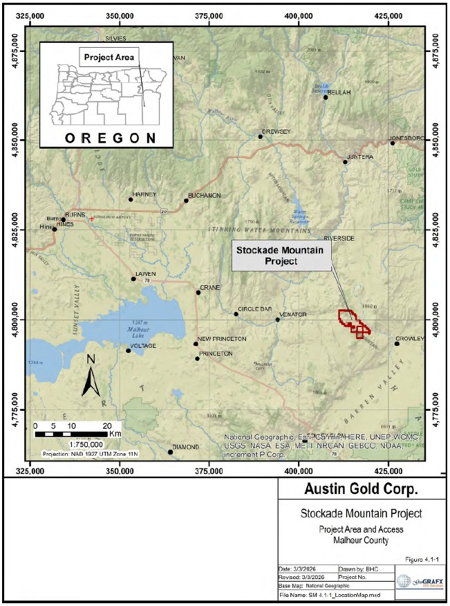
Figure 4.1-1 Stockade Mountain Project Location Map
| NI 43-101 Technical Report Stockade Mountain Project | Page: 23 | |
| Malheur County, Oregon, USA | ||
4.2 Land Tenure
The Stockade Mountain Project is located in T25S R38E Sec 27-34, T26S R38E Sec 1-5, 10, 12, 14 and T26S R39E Sec 07, 18 Willamette Meridian. It is situated on public lands administered by the United States Department of the Interior Bureau of Land Management (BLM). The Property covers approximately 10.51 square miles (27.2 km) and is comprised of 338 unpatented claims occupying 6,726 acres (2,722 ha).
Figure 4.2-1 shows the land status and configuration of the various mineral holdings comprising the Property.
4.2.1 Federal Lands
Ownership of unpatented mining claims on federal land is in the name of the holder (locator), subject to the paramount title of the United States of America, under the administration of the U.S. Bureau of Land Management. Under the Mining Law of 1872, which governs the location of unpatented mining claims on Federal lands, the locator has the right to explore, develop, and mine minerals on unpatented mining claims without payments of production royalties to the U.S. government, subject to the surface management regulation of the BLM. In recent years, there have been efforts in the U.S. Congress to change the 1872 Mining Law to include, among other items, a provision of production royalties to the U.S. government. Currently, annual claim maintenance fees are the only federal payments related to unpatented mining claims. BLM records of mining claims can be searched on-line at https://reports.blm.gov/reports/MLRS.
The located mineral claims were staked as lode claims on public lands administered by the BLM in accordance with BLM regulations which are documented online at https://www.blm.gov/programs/energy-and-minerals/mining-and-minerals/about/oregon-washington. The claims within the project area are located in the field with four substantial posts, projecting not less than three feet above the surface of the ground, and made of wood measuring not less than one and one-half inch by one and one-half inch, or by substantial mounds of stone, or earth and stone, at least two feet in height, one such post or mound of rock at each corner of such claims that conform to Oregon regulations. The unpatented mining claims have not been surveyed.
The Stockade Mountain Property consists of unpatented lode mining claims located on federal lands administered by the Bureau of Land Management. The first group of claims was staked by Bull Mountain Resources, LLC (BMR) in September 2016 and forms the basis of the Mineral Lease and Option Agreement described in Section 4.3.1. These claims carry the "SM" prefix and are recorded in the BLM Mineral & Land Records System (MRLS) as "Active" claims. According to the BLM database, these claims remain in good standing. Annual maintenance fees for these claims have been paid through the most recent filing period.
A second group of claims was staked by Austin American Corporation in 2024 within the area of interest defined in the agreement between Austin American Corporation and Bull Mountain Resources, LLC. Under the terms of that agreement, claims staked within the agreement area are considered part of the Property controlled by BMR. These claims currently appear in the BLM database with a status of "Filed", indicating that the claims have been recorded with the BLM but have not yet been adjudicated by the BLM. Annual maintenance fees for these claims have also been paid through the current filing period.
| NI 43-101 Technical Report Stockade Mountain Project | Page: 24 | |
| Malheur County, Oregon, USA | ||
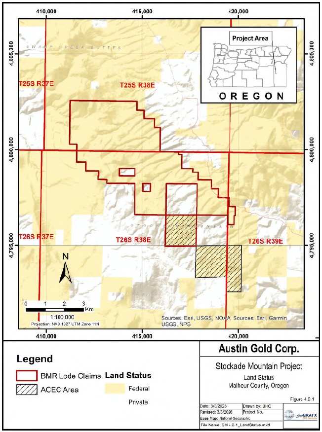
Figure 4.2-1 Land Status Map
| NI 43-101 Technical Report Stockade Mountain Project | Page: 25 | |
| Malheur County, Oregon, USA | ||
Ms. Carroll prepared a Mineral Status Report for all claims based on BLM records current as of March 2026. A complete list of the claims included in the Property, together with their BLM serial numbers and status, is provided in Appendix B and shown on Figure 4.2-2.
Annual maintenance fees of US$200 per unpatented mining claim are due to the BLM on or before September 1 each year to maintain the claims. The next annual maintenance fees are due by September 1, 2026. Additionally, a notice of intent to hold (NOI) a claim or site needs to be filed with the clerk of Malheur County accompanied by a filing fee per claim/site within 30 days after the performance of labor or making of improvements, or making federal fee payments required by law to be annually performed or made upon any mining claim (ORS 517.210 Recording affidavit of annual compliance, 2026). Malheur county NOI filing is US$16 for first page (one claim), US$5 per additional page + US$5 for each additional claim listed after the first (https://www.malheurco.org/county-clerk/county-clerk-fee-schedule/).
Holding costs of the unpatented mining claims comprising the Stockade Mountain Property that were paid in 2025 were US$ 69,357 (Table 4-1).
Table 4-1 Annual Claim Holding Costs
| BLM Maintenance Fee | US$67,600 |
| Malheur County Filing Fee | US$ 1,757 |
| Total Filing and Holding Cost | US$ 69,357 |
| NI 43-101 Technical Report Stockade Mountain Project | Page: 26 | |
| Malheur County, Oregon, USA | ||
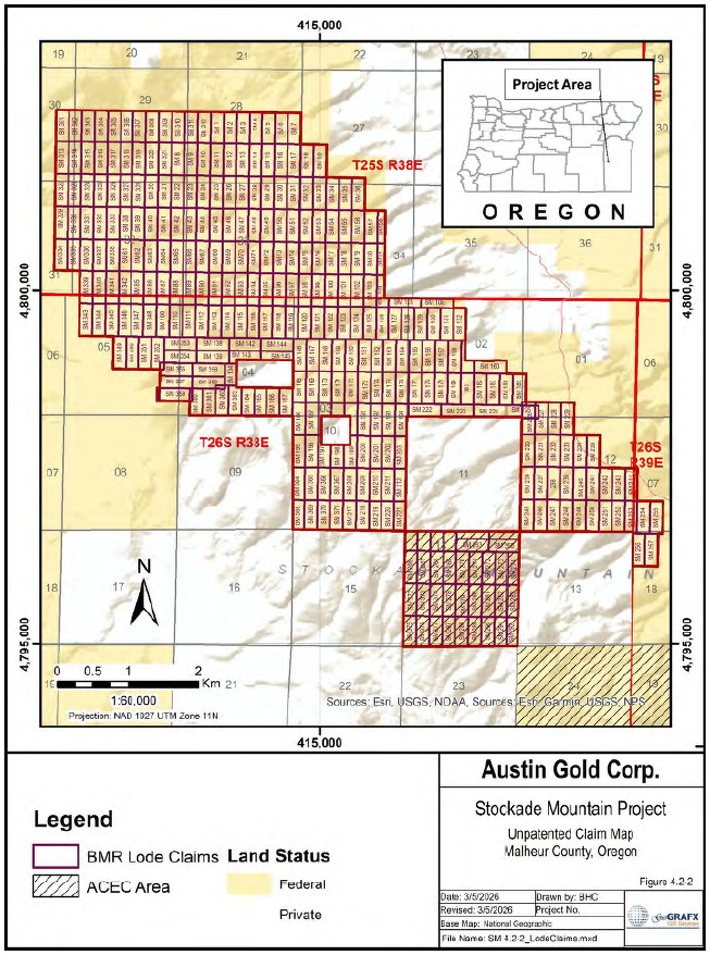
Figure 4.2-2 Unpatented Lode Claims
| NI 43-101 Technical Report Stockade Mountain Project | Page: 27 | |
| Malheur County, Oregon, USA | ||
4.3 Agreements and Encumbrances
4.3.1 Mineral Lease and Option Agreement with Bull Mountain Resources, LLC
On May 16, 2022, the Company entered into a mineral lease and option agreement with BMR through Austin American Corporation, to lease a 100% interest in the Stockade Mountain Property located in Malheur County, Oregon. The Stockade Property consists of 261 "SM" unpatented lode mining claims that cover an area of over 6,790 acres, located in Malheur County, Oregon that are held in the name of Bull Mountain Resources, LLC.
Under the terms of the agreement (Austin Gold Corp., 2022), the Stockade Lease is for a primary term of 35 years with the following work commitments:
| By May 16, 2023 | US$30,000 |
| By May 16, 2024 | Minimum 2,000 meters of drilling |
The term of the agreement may extend past 50 years provided active mining operations are being conducted on the Property.
BMR will retain a 2% net smelter return royalty on claims owned 100% by BMR, and a 0.25% NSR royalty for third-party claims and/or fee lands acquired within an area of influence around the Stockade Mountain Property. Payments to BMR totaling US$10,000,000 in any combination of pre-production payments, production and minimum royalties shall reduce BMR's royalties on wholly owned claims by 50% from 2% to 1%. The 0.25% on third-party claims and/or fee lands acquired within an area of influence remain at 0.25%.
The Company is also required to make the following pre-production payments:
| May 16, 2022 | US$15,000 |
| November 16, 2022 | US$10,000 |
| May 16, 2023 | US$10,000 |
| November 16, 2023 | US$15,000 |
| May 16, 2024 | US$15,000 |
| November 16, 2024 and every 6 months thereafter | US$25,000 |
Each cash pre-production payment shall be credited against the future production royalties as an advance royalty.
On February 28, 2024, the Company executed an amendment to the mineral lease and option agreement with BMR eliminating the requirement of 2,000 meters of drilling by May 16, 2024, (Austin Gold Corp, 2026).
4.4 Water and Surface Rights
4.4.1 Water
The Stockade Mountain Project is located in the Lower Owyhee subbasin (see Figure 4.4-1). The subbasin is located in the southeastern-most corner of Oregon in Malheur county. It covers 1,268,900 acres.
| NI 43-101 Technical Report Stockade Mountain Project | Page: 28 | |
| Malheur County, Oregon, USA | ||
A watershed is a geographic region designated by the United States Geological Survey (USGS) in which all forms of precipitation drain into streams or permeate into the ground water at the same place. Watersheds can provide a way of evaluating landscape and water relations based on the water flow through the system. The United States is divided into geographic units called hydrologic units based on drainage areas of rivers. The largest units, given first order hydrologic unit codes (HUC), are drained by a major river or series of rivers. These regions are further subdivided into areas drained by a river system. These areas in turn are split into smaller units. The lower Owyhee subbasin (hydrologic unit 17050110) is a 4th order or 8-digit hydrologic unit. It is part of the Middle Snake Boise hydrologic accounting unit, which is a member of the Middle Snake hydrologic subregion which is in turn part of the Pacific Northwest hydrologic region.
Hydrologic units (watersheds)
Pacific Northwest (hydrologic region)
Middle Snake (hydrologic subregion)
Middle Snake-Boise (hydrologic accounting unit)
Lower Owyhee (hydrologic unit 17050110)
The identification of natural variables is an important facet in describing a watershed. The lower Owyhee subbasin is a semiarid desert. This scarcity of precipitation is a major determining factor in the functioning of the subbasin. The least rainfall falls in the months of July and August. The greatest precipitation is during the winter and early spring months. The months of July and August are also the hottest.
Most of the lower Owyhee subbasin lies within the Owyhee uplands. Since the Owyhee uplands are a semiarid desert with very few sources of perennial water, the landscape is primarily dissected by intermittent drainages and ephemeral streams which flow only following rainstorms or snow melt. The erosional processes which are forming the landscape follow major storm or storm on snow events. Runoff events are aggravated when the soil is frozen. Surface water availability for grazing animals is quite low because access to major rivers is largely constrained by cliffs. Although most of the water in the drainage comes as precipitation in the winter and spring months, there are some springs in the area. Surface water has been enhanced by stock ponds, pipelines and reservoirs (Owyhee Watershed Council and Scientific Ecological Services, 2008).
Springs suitable as sources for exploration drilling water may be available on site; however, more substantial quantities of water will be required for future exploration and development.
On February 28, 2025, the Company received permission from the Oregon Water Resources Department to drill a water well to produce water for exploration drilling and plans to drill the well to ensure water is available for future drilling campaigns.
| NI 43-101 Technical Report Stockade Mountain Project | Page: 29 | |
| Malheur County, Oregon, USA | ||
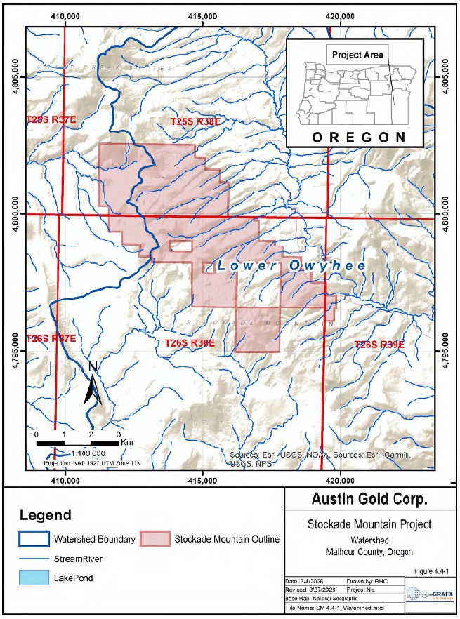
Figure 4.4-1 Stockade Mountain Watershed
| NI 43-101 Technical Report Stockade Mountain Project | Page: 30 | |
| Malheur County, Oregon, USA | ||
4.4.2 Surface Rights
4.4.2.1 BLM grazing allotments on Federal Lands
In Oregon and Washington, the BLM administers 1,596 ten-year permits and leases held by ranchers who graze their livestock (mostly cattle and sheep) on 2,003 allotments. The BLM Vale District is the largest grazing district and has the greatest number of allotments. Permits and leases generally cover a 10-year period and are renewable if the BLM determines that the terms and conditions of the expiring permit or lease are being met.
The grazing allotments in the Stockade Mountain Project area are managed by the Malheur Field office (ORV04).
Cattle grazing rights are available to local ranchers throughout the Stockade Mountain Project. It is recommended that Austin Gold coordinate their exploration activities on the BLM lands, to the extent possible, with the holders of grazing allotments so that neither party unreasonably interferes with the other's use, and that Austin Gold take reasonable precaution to fence cattle out of, and to enclose, drill holes and wastewater disposal sites.
4.5 Environmental, Reclamation and Permitting
4.5.1 Environmental Liabilities
There are no known environmental liabilities that are adversely impacting air, water or soil resources on the Stockade Mountain Project. However, it should be noted that the project area has been the subject of exploration activity since the 1990s and, as such, there are reclaimed drill roads and drill pads on the Property. It is not known to what extent, if any, the Company may be responsible for the reclamation of these existing workings. Any excavation representing a safety hazard to field personnel or livestock should be fenced and have the appropriate signage.
4.5.2 Environmental Considerations
The BLM's twenty-year-old National Conservation Lands currently includes over 906 units covering about 38 million acres designated by Congress and the President to conserve special features. Primarily located in the West, the BLM's National Conservation Lands consist of National Monuments, National Conservation Areas, Wilderness Areas, Wilderness Study Areas, Wild and Scenic Rivers, National Scenic and Historic Trails, and Conservation Lands of the California Desert. BLM Oregon-Washington manages National Monuments, National Scenic and Historic Trails, Wild and Scenic Rivers, Wilderness, and more unique National Conservation Lands. The BLM manages these public lands for the benefit of current and future generations, supporting conservation as a part of the BLM's multiple-use mission.
The designation of an Area of Critical Environmental Concern (ACEC) is to highlight areas where special management attention is needed to protect, and prevent irreparable damage to important historical, cultural, and scenic values, fish, or wildlife resources or other natural systems or processes, or to protect human life and safety from natural hazards (BLM Manual 1613, 1988).
There are no designated wilderness or Wilderness Study Areas (WSAs), Wild and Scenic Rivers (WSRs), or Research Natural Areas (RNAs) within or near the Stockade Mountain Project area. A portion of the Project lies within the BLM-designated Stockade Mountain Area of Critical Environmental Concern. The Stockade Mountain ACEC is approximately 649 acres in size. The Stockade Mountain ACEC is managed to preserve wildlife habitat and old growth western juniper/big sagebrush/bunchgrass communities within interspersed low sagebrush communities identified by the Oregon Nature Heritage Program (ONHP) (Hanley, Gonzalez, & Ryan, May 2019).
| NI 43-101 Technical Report Stockade Mountain Project | Page: 31 | |
| Malheur County, Oregon, USA | ||
Figure 4.2-1 shows the location of the Stockade Mountain Project area in relation to the ACEC areas.
4.5.3 Endangered Species and Critical Habitat
The Federal Endangered Species Act of 1973 (ESA) (16 U.S.C.A. §§ 1531 et seq.) provides a program for the conservation of threatened and endangered plants and animals and the habitats in which they are found. Under the ESA, species may be listed as either endangered or threatened. "Endangered" means a species is in danger of extinction throughout all or a significant portion of its range. "Threatened" means a species is likely to become endangered within the foreseeable future. All species of plants and animals, except pest insects, are eligible for listing as endangered or threatened. For the purposes of the ESA, Congress defined species to include subspecies, varieties, and, for vertebrates, distinct population segments.
The ESA is administered by the U.S. Fish and Wildlife Service (USFWS) and the Commerce Department's National Marine Fisheries Service (NMFS). The USFWS has primary responsibility for terrestrial and freshwater organisms, while the responsibilities of NMFS are mainly marine wildlife such as whales and anadromous fish such as salmon. These agencies may list a species on their own initiative, or any interested person may submit a petition to have a species considered for listing. In either case, the ESA requires that the decision to include a species be based solely on the "best scientific and commercial data available," following a review of the status of the species that takes into account any conservation efforts being made to protect the species (§ 1533 (b)(1)(A)).
The law requires federal agencies, in consultation with the U.S. Fish and Wildlife Service and/or the NOAA Fisheries Service, to ensure that actions they authorize, fund, or carry out are not likely to jeopardize the continued existence of any listed species or result in the destruction or adverse modification of designated critical habitat of such species. The law also prohibits any action that causes a "taking" of any listed species of endangered fish or wildlife. Likewise, import, export, interstate, and foreign commerce of listed species are all generally prohibited.
4.5.3.1 Endangered Species
Information for Planning and Consultation (IPaC) https://ecos.fws.gov/ipac/ is a project planning tool provided by the Environmental Conservation Online System (ECOS) operated by the USFWS which identifies potential issues in a project area such as migratory birds, species proposed or listed under the Endangered Species Act, inter-jurisdiction fishes, specific marine mammals, wetlands, and Service National Wildlife Refuge lands.
ECOS (2026) indicates that for the Stockade Mountain Project area as of 5 March 2026, the following species are potentially affected by activities in this location:
INSECTS
| Name | Status |
| Monarch Butterfly Danaus plexippus | Proposed Threatened |
| Wherever found | |
| There is proposed critical habitat for this species. Your location does not overlap the critical habitat. | |
| Suckley's Cuckoo Bumble Bee Bombus suckleyi | Proposed Endangered |
| No critical habitat has been designated for this species. |
| NI 43-101 Technical Report Stockade Mountain Project | Page: 32 | |
| Malheur County, Oregon, USA | ||
There are no listed threatened or endangered species or critical habitat as defined under the Endangered Species Act (ESA) (USFWS, 2015) (31). There are no Bald and Golden Eagles or migratory birds of conservation concern expected to occur at the project location. There are no National Wildlife Refuge lands or fish hatcheries at this location.
4.5.3.2 Bald and Golden Eagles
Bald and Golden Eagles are protected under the Bald and Golden Eagle Protection Act and the Migratory Bird Treaty Act (MBTA). These statutes prohibit the take, possession, or disturbance of eagles, including impacts to nests and nesting territories.
Regional occurrence data compiled through the Avian Knowledge Network (AKN) indicate that no Bald or Golden Eagle observations have been recorded within the project area. However, the absence of recorded observations does not preclude the presence of eagles in the area, particularly in locations that may be under-surveyed.
A raptor survey conducted by Nexus Environmental Consultants, Inc. (2025) for Austin American Corporation identified one occupied golden eagle territory within a two-mile buffer of the Project. This territory is located approximately 1.9 miles east of the southeastern Project boundary and includes at least three nests, consisting of one occupied nest (CC-03-B) and two alternate nests (CC-03-A and CC-03- C). Nest CC-03-B was occupied during both survey years and successfully produced at least one fledgling in 2025. Nest productivity was not monitored in 2024.
One additional nest (CC-02-A) located within the survey area was occupied by a long-eared owl in both survey years. Nest productivity for this species was not monitored.
4.5.3.3 Migratory Birds
Migratory birds are protected under the Migratory Bird Treaty Act, which prohibits the take of protected species, including killing, capturing, or disturbing active nests, without authorization from the U.S. Fish and Wildlife Service.
Project-specific species occurrence data derived from the Avian Knowledge Network indicate that no migratory birds of conservation concern have been recorded within the project area. These datasets are based on available survey, banding, and observational records within the relevant geographic grid cells.
The absence of recorded species of conservation concern does not indicate that migratory birds are not present in the project area, particularly where survey coverage may be limited. Suitable habitat within the project area may support migratory bird species on a seasonal basis.
4.5.3.4 Sage Grouse Habitat
Federal and state agencies have implemented land management strategies across the western United States to conserve Greater Sage-Grouse (Centrocercus urophasianus) habitat while allowing continued multiple use of public lands. In 2015, the Bureau of Land Management and U.S. Forest Service adopted land use plan amendments establishing conservation measures for sage-grouse habitat across ten western states. These plans introduced habitat management designations and management measures intended to reduce surface disturbance and maintain habitat connectivity.
| NI 43-101 Technical Report Stockade Mountain Project | Page: 33 | |
| Malheur County, Oregon, USA | ||
During this period, the Department of the Interior also proposed withdrawal of approximately 10 million acres of Sagebrush Focal Areas (SFAs) from location and entry under the United States mining laws. The withdrawal application was later canceled in October 2017, and the affected lands remained open to mineral entry subject to valid existing rights and applicable federal land management regulations (Nedd, 2017).
Subsequent revisions to the sage-grouse management plans were proposed in 2019 but were subject to litigation and administrative review. The BLM has since completed updated range wide planning, and in January 2025 issued a Record of Decision (ROD) approving Resource Management Plan Amendments for Greater Sage-Grouse conservation in Oregon and Colorado. These amendments update management direction for sage-grouse habitat on BLM-administered lands while maintaining a coordinated approach with state wildlife agencies and other stakeholders (Bureau of Land Management, 2025)
Sage-grouse populations in Oregon are managed using habitat designations developed by the Oregon Department of Fish and Wildlife (ODFW), including Core Habitat Areas, Low Density Habitat Areas, and Priority Areas for Conservation (PACs). PACs represent landscapes that support important breeding populations and are used as the primary framework for conservation planning and population monitoring. The Crowley PAC is located in central Malheur County within the Vale District of the BLM and encompasses multiple known sage-grouse lek complexes. Habitat mapping used by the BLM for land management planning incorporates the ODFW Core and Low Density habitat designations and forms the basis for Priority Habitat Management Areas (PHMA) and General Habitat Management Areas (GHMA). GHMA represents additional seasonal or transitional habitats and are managed to support sage-grouse populations while allowing greater flexibility for land use activities. These are identified in the 2025 Greater Sage-Grouse Resource Management Plan Amendments Record of Decision (Bureau of Land Management, 2025). Figure 4.5-1 shows Greater Sage-Grouse habitat (GRSG) areas near the Stockade Mountain Project, including PHMA and GHMA. The ODFW online Development Siting Tool (2017) indicates that the Project area is within or adjacent to GRSG habitat.
During recent decades, wildfire has affected portions of sagebrush habitat within the Vale District of the Bureau of Land Management in eastern Oregon. During the summer of 2014, the Saddle Draw wildfire, part of the Buzzard Complex, burned over 280,000 acres of rangeland in portions of Harney and Malheur counties, including areas near the Crowley PAC (Figure 4.5-1). Wildfires in sagebrush ecosystems can temporarily reduce shrub cover and alter habitat conditions used by Greater Sage-Grouse until vegetation recovery occurs. Habitat condition is described by the ecological states (Ecostates) that express current vegetation composition and level of threat from invasive annual grasses, wildfire, and juniper encroachment. The specific effects of this wildfire on sage-grouse populations or habitat conditions in the immediate project area are not known.
| NI 43-101 Technical Report Stockade Mountain Project | Page: 34 | |
| Malheur County, Oregon, USA | ||
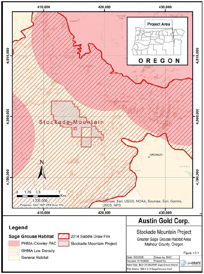
Figure 4.5-1 Greater Sage Grouse Habitat
| NI 43-101 Technical Report Stockade Mountain Project | Page: 35 | |
| Malheur County, Oregon, USA | ||
The Stockade Mountain Property is located entirely within General Habitat Management Area for Greater Sage-Grouse habitat and lies approximately one mile south of the Crowley PAC (Figure 4.5-1). Potential impacts of future exploration activities on sage-grouse habitat have not been evaluated, as no site-specific environmental baseline studies have been conducted for the Property. Prior to undertaking additional exploration activities, it is recommended that the operator consult with the Bureau of Land Management regarding applicable requirements for avoiding, minimizing, or mitigating potential impacts to sagebrush habitat.
4.5.3.5 Wetlands
Impacts to National Wetlands Inventory (NWI) and other aquatic habitats may be subject to regulation under Section 404 of the Clean Water Act, or other state and federal statutes. Figure 4.5-2 shows the Stockade Mountain Project in relation to the wetland areas.
Based on the available NWI mapping, wetlands and other aquatic features occur locally within the broader project area; however, these features appear to be limited in extent and are not expected to represent a significant constraint to future exploration activities, although site-specific verification and permitting may be required if disturbance of jurisdictional waters is proposed.
| NI 43-101 Technical Report Stockade Mountain Project | Page: 36 | |
| Malheur County, Oregon, USA | ||
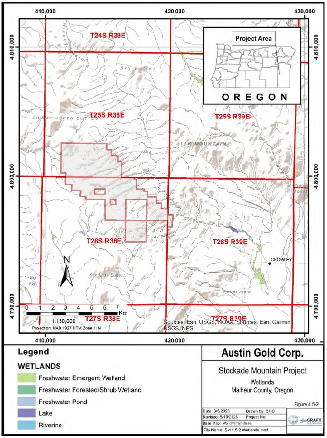
Figure 4.5-2 Stockade Mountain Wetland Areas
| NI 43-101 Technical Report Stockade Mountain Project | Page: 37 | |
| Malheur County, Oregon, USA | ||
4.5.3.6 Conclusions
Austin Gold has not completed a comprehensive environmental or permitting review of the project area; therefore, unknown challenges related to permitting and conducting exploration, development, or mining activities may exist.
Based on currently available information, no federally listed threatened or endangered species or designated critical habitat have been identified within the project area. However, proposed species, including the monarch butterfly and Suckley's cuckoo bumble bee, have been identified at a regional level and may require consideration during future permitting.
The project area is located entirely within mapped Priority Habitat Management Area for Greater Sage- Grouse, and an active golden eagle territory has been documented within approximately two miles of the Property boundary. These factors indicate that wildlife habitat considerations will be an important component of future permitting and project planning, particularly with respect to timing restrictions, disturbance limitations, and consultation requirements.
Although no wildlife management issues have been identified that would preclude exploration activities, regulatory requirements related to sage-grouse habitat, raptor protection, and migratory birds may impose constraints on the timing and scope of such activities.
It is recommended that Austin Gold consult with the Bureau of Land Management and other relevant agencies to identify applicable requirements for avoiding, minimizing, and mitigating potential impacts to wildlife habitat in advance of future exploration activities on BLM-managed lands.
4.5.4 Access
In the project area, access to the unpatented mining claims is provided by existing public roads, roads crossing private lands, and roads located on BLM lands. Use of roads across BLM lands is governed by BLM rules and policies under the Federal Land Policy and Management Act (FLPMA). Applicable BLM regulations are found in Title 43 of the Code of Federal Regulations (CFR), Parts 3700 and 3800.
Future exploration activities on the Property may require the use of local ranch roads that cross private lands. At present, there is no formal written access agreement with the relevant landholders for the use of these roads. Historically, these roads have been used for local access; however, any future exploration work that requires their use should be coordinated with the respective landowners. Gates encountered along these roads must be opened and closed as required, and any use of the roads should be conducted with the permission of the landowners and with appropriate maintenance during exploration activities.
Local access to the project area is attained by a network of unimproved dirt roads and primitive jeep trails maintained, in part, by the U.S. Bureau of Land Management. Road travel is generally restricted to four-wheel-drive vehicles. The approved BLM Exploration Notice for the Stockade Mountain Project also authorizes the construction of short temporary access roads associated with drill pads and exploration drilling activities. These access routes would be used during drilling operations and reclaimed in accordance with BLM surface management regulations.
4.5.5 Permitting
Drilling and associated road building on BLM lands disturbing less than 5 acres requires a "Notice" of the planned operations. In Oregon, an "Exploration Permit" from the Oregon Department of Geology and Mineral Industries (DOGAMI) is required for exploration where drilling exceeds 50 feet in depth or the operations disturb more than one acre.
| NI 43-101 Technical Report Stockade Mountain Project | Page: 38 | |
| Malheur County, Oregon, USA | ||
4.5.5.1 Bureau of Land Management
The U.S. Department of the Interior, Bureau of Land Management, administers mineral access on federal public lands on which the Project is located under the General Mining Law of 1872.
BLM's regulations describe three categories of use on federal lands:
(1) casual use,
(2) activities that exceed casual use but disturb less than 5 acres, and
(3) operations that exceed casual use that will disturb more than 5 acres.
No permit is required for casual use exploration (i.e., non-mechanical activities), such as geological mapping, geochemical sampling, or geophysical surveying conducted without surface disturbance.
Exploration activities disturbing five acres or less require submission of a Notice to the BLM. The BLM reviews such Notices and may require additional review under applicable federal laws, including the National Environmental Policy Act, National Historic Preservation Act, and Endangered Species Act, prior to approving the proposed activities.
Surface disturbance exceeding a total of 5 acres or occurring within certain special designation areas, including Areas of Critical Environmental Concern, requires submission and approval of a Plan of Operations. Portions of the Stockade Mountain Project are located within a designated ACEC. Accordingly, exploration activities involving surface disturbance greater than casual use within these areas would require approval of a Plan of Operations.
Where a Plan of Operations is required, the operator hires contractors to conduct biological, animal species, and cultural baseline studies, the results of which are submitted to the BLM. The BLM then conducts an environmental review, which may include preparation of an Environmental Assessment or Environmental Impact Statement. Approval is contingent upon compliance with applicable regulatory requirements.
Use of roads across BLM lands is governed by BLM rules and policies under the Federal Land Policy and Management Act. The BLM also requires the posting of bonds for reclamation for any surface or subsurface disturbance caused by more than casual use (43 CFR 3809.500 through 3809.560).
The BLM field office with jurisdiction over the project area is the Vale District Office, located at 100 Oregon Street, Vale, Oregon 97918. This office provides guidance regarding allowable exploration activities and establishes reclamation bonding requirements associated with mineral exploration.
4.5.5.2 Oregon Department of Geology and Mineral Industries
The Oregon Department of Geology and Mineral Industries (DOGAMI) is an independent state agency, established in 1937, responsible for regulating mineral exploration and surface mining activities in Oregon. Its Mineral Land Regulation & Reclamation (MLRR) program administers permitting and reclamation requirements intended to minimize environmental impacts associated with mining activities specifically for sites exceeding one acre of disturbance or 5,000 cubic yards of excavation within a 12- month period. The three types of surface mining approvals that DOGAMI issues include Operating Permits for significant mining, requiring reclamation plans, Exploration Permits for operations that disturb more than one surface acre and/or involve drilling to greater than 50 feet, and Exclusion Certificates for small-scale, short-term mining (less than 5,000 cubic yards and less than one acre).
| NI 43-101 Technical Report Stockade Mountain Project | Page: 39 | |
| Malheur County, Oregon, USA | ||
4.5.5.3 Current Permits
In October 2022, Austin American Corporation submitted an Exploration Notice to the Bureau of Land Management, Vale District, Malheur Field Office (BLM Case File OROR-71670) for the Stockade Mountain Project (BLM Case File OROR-71670) to conduct exploration drilling on unpatented mining claims in Malheur County, Oregon.
The approved program initially included up to 16 drill holes and associated pads. In May 2024, an amendment to the Notice was submitted and approved in June 2024, reducing the program to 10 drill holes and modifying the disturbance footprint. The amended program results in a total surface disturbance of approximately 4.63 acres, which is within the threshold for Notice-level operations under 43 CFR 3809.
The BLM required a reclamation financial guarantee of $31,310 for the approved program. The Notice authorization remains valid for a period of two years from the date of amendment approval. Approval for access road construction and drilling activities was granted by the BLM in the fourth quarter of 2022.
Exploration activities in Oregon that create surface disturbance also require approval from DOGAMI. In October 2022, Austin American Corporation submitted an Exploration Permit Application to DOGAMI under ORS 517.702-517.901. The application included the required forms, a non-refundable application fee of $2,000, and an Exploration and Reclamation Plan. DOGAMI required an exploration bond of $43,252 for the proposed activities. The Exploration Permit was approved in the third quarter of 2023.
Based on the above, the permits required to construct access roads and conduct the approved exploration drilling program have been obtained.
Future exploration activities that exceed the scope or disturbance limits of the approved Notice may require modification of the existing Notice or submission of a Plan of Operations, depending on the nature and extent of the proposed work.
4.5.6 Reclamation
In Oregon, reclamation bonding for roads and drill sites is typically required by both the BLM and the DOGAMI. A review of BLM records indicates that reclamation associated with historical drilling programs conducted by BHP-Utah International, Phelps Dodge, and Placer Dome has been completed. Drill pads and access roads from these programs have been reclaimed.
No permitted work was conducted on the Property between the completion of the historical drilling programs in 1993 and approval of the current BLM Exploration Notice for the Stockade Mountain Project in October 2022.
As of December 31, 2025, the Company maintains reclamation surety bonds of $38,863 with the BLM and $43,252 with DOGAMI in support of the reclamation requirements of the approved exploration program.
| NI 43-101 Technical Report Stockade Mountain Project | Page: 40 | |
| Malheur County, Oregon, USA | ||
5 ACCESSIBILITY, CLIMATE, LOCAL RESOURCES, INFRASTRUCTURE AND PHYSIOGRAPHY
This section summarizes the physical setting of the Stockade Mountain Property, including access routes, regional infrastructure, physiography, and climate conditions relevant to mineral exploration and potential development.
The information summarized in this section is derived from publicly available sources, as cited. The Qualified Person has reviewed this information and believes the summary to be materially accurate.
5.1 Access
The Stockade Mountain Property is located in the Stockade Mountains approximately 54 miles southeast of Burns, Oregon, the county seat of Harney County.
Primary access to the project area from Burns is by taking Highway 78 approximately 29 miles southeast to Crane, then the wide, graveled Crane-Venator Road about 29 miles to the Whisky Creek Road turnoff. The Whisky Creek Road and another dirt road lead directly to the northwest end of the project area and consist of approximately 11.5 miles of good dirt road, but which can get muddy during wet weather.
Access to the east side of the project area is via the Crane-Venator Road to the Swamp Creek Road and then southeasterly 9.5 miles on the Crowley-Riverside Road to a dirt road that leads southwesterly into the Property. Travel time from Burns to the project area is approximately 2.5 hours via either route.
Four-wheel-drive roads provide access to the Property and allow exploration access to the project area.
Air access to the region is available via Burns Municipal Airport, a level 3 industrial zoned general aviation airport, located approximately 48 miles northwest of the project area.
5.2 Local Resources and Infrastructure
The closest significant towns to the project area are adjoining Burns and Hines, Oregon, full-service ranching and farming communities that have multiple options for lodging, RV parks, restaurants, fuel, rental equipment, and spare parts. Burns has a population of approximately 2,689 (2024) and Hines has a population of approximately 1,621 (2024). Juntura, located in Malheur County, Oregon (population approximately 57), provides limited services including a small motel with RV spaces and a restaurant.
A trained mining and industrial workforce is available in Boise, Idaho, approximately 100 miles (161 km) northeast of the project area. Boise also provides access to mining and industrial equipment suppliers, engineering services, telecommunications infrastructure, medical facilities, banking, and a regional commercial airport with daily air service to larger western transportation hubs such as Denver and Salt Lake City.
Springs suitable as potential sources of water for exploration drilling occur on and near the Property. However, Austin intends to drill a water well on a permitted drill site to provide a reliable water source for exploration drilling. The well permit has been obtained through the Oregon Water Resources Department and is intended to minimize potential conflicts with local ranching activities in the area. Additional water required for potential future development may be available from surface or groundwater sources in adjacent valleys.
| NI 43-101 Technical Report Stockade Mountain Project | Page: 41 | |
| Malheur County, Oregon, USA | ||
The claims cover approximately 6,726 acres and include areas potentially suitable for future mining infrastructure such as access roads, waste rock storage areas, heap leach facilities, processing facilities, and other supporting infrastructure.
5.3 Physiography
The Stockade Mountain Project lies within the High Lava Plains and the Owyhee Uplands and Canyons subregion of the Northern Basin and Range ecoregion. Ecoregions represent areas where ecosystems and environmental resources are generally similar. This classification framework was developed by Omernik (1987) and further refined through collaborative mapping efforts involving the U.S. Environmental Protection Agency, other federal agencies, and state resource management organizations.
The High Lava Plains are characterized by a relatively flat to gently undulating volcanic plateau drained by ephemeral and intermittent streams. The adjacent Owyhee Uplands and Canyons subregion is characterized by more rugged terrain with dissected hills and steep slopes. Figure 5.3-1 illustrates the relationship between these ecoregions and the project area (Thorson, 2003).
| NI 43-101 Technical Report Stockade Mountain Project | Page: 42 | |
| Malheur County, Oregon, USA | ||
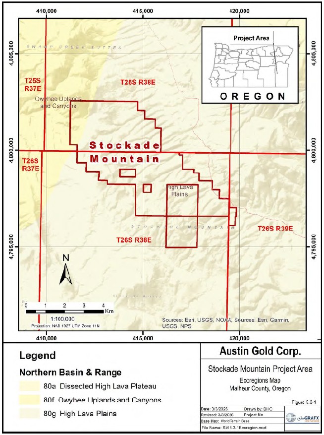
Figure 5.3-1 Stockade Mountain Ecoregion Map
| NI 43-101 Technical Report Stockade Mountain Project | Page: 43 | |
| Malheur County, Oregon, USA | ||
In the project area, as shown in Figure 5.3-2, topography is generally gentle with local relief ranging from approximately 500 to 1,000 feet between pediments and ridge crests. Bedrock exposure varies from common along ridges and dry drainages to sparse along some ridge flanks. Rhyolite and basalt commonly form resistant outcrops, whereas opalite-chalcedony and tuff breccia units tend to be less resistant and more subdued in outcrop expression. In most locations, bedrock occurs within a few feet of the ground surface unless locally covered by Tertiary-Quaternary gravels or recent landslide debris (Mejstrick & Dodd, 1993).
Vegetation in the project area consists primarily of Wyoming big sagebrush, basin big sagebrush, Douglas rabbitbrush, bluebunch wheatgrass, Idaho fescue, bottlebrush squirreltail, Sandberg bluegrass, and cheatgrass. Higher ridges and sheltered areas support scattered western juniper. The area is used seasonally for cattle grazing from spring through fall. Cheatgrass has replaced depleted bunchgrasses in burned and overgrazed areas.
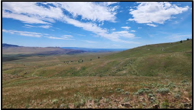
Figure 5.3-2 Typical Physiography of the Project Area
5.4 Climate
The climate of the project area is semi-arid continental, typical of southeastern Oregon. Summers are generally short, warm, and dry, while winters are cold with variable snowfall and precipitation.
Published climate data specific to the Stockade Mountains are limited. Climate conditions at Burns, Oregon, located approximately 54 miles northwest of the project area, provide a representative regional proxy. Based on long-term climate records, temperatures typically range from approximately 16°F in winter to 87°F in summer. Average annual precipitation is approximately 10.9 inches (NOAA climate normals; regional climate summaries).
| NI 43-101 Technical Report Stockade Mountain Project | Page: 44 | |
| Malheur County, Oregon, USA | ||
Snowfall may limit access during winter months, typically from December through April. Seasonal precipitation may also temporarily affect road conditions. Exploration activities such as drilling may therefore be seasonally constrained. Potential future mining operations would likely be feasible year- round with appropriate road maintenance and snow removal.
| NI 43-101 Technical Report Stockade Mountain Project | Page: 45 | |
| Malheur County, Oregon, USA | ||
6 History
6.1 Previous History
In the region, geologic exploration of the Owyhee uplands lagged far behind that in other areas of Oregon. This was due partly to its harsh climate, the rough black basalt landscape, its lack of gold or silver discoveries and its physical isolation from wagon routes crossing the state (Orr & Orr, 2012).
Prior to prospecting by Carlin Gold and others in 1987, there is no record of exploration activity at Stockade Mountain (Spatz, 1991).
6.2 Stockade Mountain Recent History
There was renewed interest in the region in the late 1980s as exploration companies pushed northward from Nevada into Idaho and Oregon looking for near surface, open pittable, heap leachable gold mineralization. The Stockade Mountain Property and adjoining areas were explored by companies such as Phelps Dodge, BHP-Utah, Placer Dome, and Carlin Gold in the late 1980s and early 1990s, After about a 20-year hiatus, La Cuesta International, The Electrum Group, and P2 Gold Inc. conducted exploration on the Property from 2014 to 2021 prior to Austin Gold's involvement.
Between 1989 and 1993, over 1,140 soil samples were collected on the Stockade Mountain Property and surrounding areas by BHP-Utah and Phelps Dodge. Over 800 rock chip samples were collected by Carlin Gold, BHP-Utah, Phelps Dodge, and Placer Dome. BHP- Utah, Phelps Dodge and Placer Dome conducted reconnaissance level mapping on their claims. Both Phelps Dodge and Placer Dome performed detailed mapping on selected areas within their claim blocks. An inventory of known drilling totals 29,310 feet in 57 reverse circulation holes drilled by Carlin Gold, BHP-Utah, Phelps Dodge, and Placer Dome to explore and define near-surface gold mineralization on Austin's leased claims and adjacent private property. Newmont examined the Carlin Gold claims and ran a single Jerome mercury line on the Property. VLF geophysical surveys were performed by both BHP-Utah and Placer Dome to delineate subsurface structures. To date, limited metallurgical surveys have been conducted at the Stockade Mountain Project area.
La Cuesta International, Inc. (LCI) and The Electrum Group LLC (TEG) recognized Stockade Mountain as a high level low-sulfidation epithermal gold system based on their geologic mapping, surface sampling and review of previous work. From 2014 through 2017, they collected over 350 rock chip samples, and LCI completed a 1:10,000 reconnaissance geologic map covering most of the Stockade Mountain Project Area. TEG and their contractors compiled the previous mapping into a GIS database and completed outcrop maps at a scale of 1:1,000.
Table 6-1 Documented Recent Work in the Stockade Mountain Area
| Date | Company | Work Performed |
| 1989-1992 | Carlin Gold | Mapping, Surface Geochem, Drilling |
| 1990 | BHP-Utah | Mapping, Geochemical Sampling, Geophysics, Drilling |
| 1990-1992 | Phelps Dodge | Mapping, Geochemical Sampling, Drilling |
| 1992 | Newmont Exploration | Hg Geochemistry |
| 1993 | Placer Dome | Mapping, Geochemical Sampling, Drilling |
| 2014-2016 | La Cuesta International | Geochemical Sampling, Mapping |
| 2016-2020 | The Electrum Group | Mapping, Geochemical Sampling |
| 2020-2021 | P2 Gold | Data Compilation, Geophysics |
| NI 43-101 Technical Report Stockade Mountain Project | Page: 46 | |
| Malheur County, Oregon, USA | ||
The existing database consists of geological reports (often only fragments), maps and drill data dating back to the 1990s from various exploration companies looking for mid-tertiary hot spring gold deposits. The data found to date is incomplete and can only be used as it exists. Much of the information on drilling done in the 1990s comes from more recent reports, not original documents. The drill data does not cover all holes drilled, so total footage and other drill data are only approximations. It is possible that other unknown companies have evaluated the area. A summary of the companies involved with the Stockade Mountain Property and surrounding areas and the work carried out is taken largely from (Mejstrick & Dodd, December 1993) with additional details listed below.
6.2.1 1989 - 1992 Carlin Gold
Carlin Gold produced a sketch map of the Property and collected 123 rock chip samples within their claim block from 1989 through 1992. TKS Consulting (Smith, 1989) reported it conducted preliminary geologic and geochemical reconnaissance at Stockade Mountain.
In 1992, six reverse circulation holes were drilled in a fence pattern in opalite-chalcedony mineralization in the SE quarter of Section 32 and one hole was drilled to evaluate covered mineralization in the NW quarter of Section 33 for a total of 2,860 feet (Mejstrick & Dodd, December 1993).
6.2.2 1990 BHP - Utah International
BHP-Utah leased the Carlin Gold claims and the McEwen private land during 1990. Reconnaissance mapping was conducted at a scale of 1" =500' over a several square mile area. Three-hundred-twenty rock chip samples and 1,065 soil samples were analyzed for Au, and in some cases Ag, base metals and trace elements. Thirty-six stream sediment samples also were analyzed. A VLF survey was conducted in the area of the rhyolite dome peripheral to the project area. Eighteen reverse circulation rotary holes with a total of 6,205 feet were drilled in a two phase program.
6.2.3 1990 - 1992 Phelps Dodge
Phelps Dodge leased the Talbot and Snyder claims from 1990 to 1992. Mapping within the claim block was conducted at scales of 1" =400' and 1" =200'. Several hundred rock and soil samples were analyzed for Au, Ag, base metals and trace elements. Twenty-two reverse circulation rotary holes with a total of 9,305 feet were drilled in a two-phase program in 1990 and 1991.
6.2.4 1992 Newmont Exploration
Newmont reviewed the Property as a submittal from Carlin Gold in 1992. A single Jerome mercury line 10,000 feet long was run from the rhyolite dome in Section 4 southeast to the dome in Section 11. Anomalous mercury was identified only near the rhyolite domes.
6.2.5 1993 Placer Dome
All Placer Dome exploration was completed during 1993. The Property was mapped at a scale of 1" = 500' with detailed mapping at a scale of 1" = 200' for a 2.5 square mile area in the northern part of the claim block. Sixty-eight rock samples were analyzed for Au, Ag, base metals and trace elements. A geophysical resistivity survey was conducted on a 1,600' x 2,400' grid with 200 foot line spacing and 50 foot station spacings on opalite-chalcedony mineralization in the SE quarter of Section 32 and the SW quarter of Section 33. Several isolated reconnaissance lines also were evaluated. Ten reverse circulation holes were drilled for a total of 4,330 feet. Geologic data from earlier investigations were evaluated and incorporated into Placer Dome target concepts.
| NI 43-101 Technical Report Stockade Mountain Project | Page: 47 | |
| Malheur County, Oregon, USA | ||
6.2.6 2014-2016 La Cuesta International
After a 20-year hiatus in exploration on the Property, Stockade Mountain was first identified as an exploration project of interest by La Cuesta International, Inc. in July 2014. LCI was conducting grassroots exploration in the Owyhee region at the time under a consulting agreement with The Electrum Group LLC. As part of their regional evaluation, LCI had assembled exploration-relevant data on 1:250,000 scale AMS sheet geologic base maps and overlays. Their compilation work showed that the Stockade Mountain area is located to the west of the intersection of the prominent WNW Burns- Mahogany Lineament and the NNE-trending Fields Lineament. In addition, LCI was attracted to the area by the fact that the Burns-Mahogany Lineament is the loci for a number of elongate WNW silicic volcanic vents and dome fields that LCI felt could potentially drive important paleo-hydrothermal fields.
After multiple visits to Stockade Mountain by LCI and after completing reconnaissance-scale mapping and sampling, the Property was recommended for acquisition to TEG. Stockade Mountain became an accepted Property under the term of the LCI-TEG consulting agreement and TEG began locating a total of 292 "SM" lode mining claims on September 6, 2016. TEG reduced their land holdings at Stockade Mountain to 261 claims and then informed LCI on April 28, 2020, of its intention to abandon the Project. Under the terms of the LCI-TEG consulting agreement, LCI had the right to reclaim ownership to the claims and on May 15, 2020, the 261 SM claims were quitclaimed to a newly formed company, Bull Mountain Resources, LLC.
6.2.7 2016-2020 The Electrum Group
In addition to La Cuesta's sampling efforts of 2014 and 2016, additional sampling and reconnaissance efforts by Electrum personnel (L. Buchanan) resulted in TEG's selection of Stockade as a project. A follow up detailed mapping program was initiated in October of 2016; this program took the form of rock sampling coupled with selective area larger scale geological, alteration, and mineralization mapping at scales of 1:5,000, 1:2,000 and 1:1,000. The field mapping and rock sampling efforts by L. Buchanan and I. Nelson along with field assistance from X. Buchanan in late 2016 resulted in an enhanced understanding of the geology. The mapping results are available in four 1:2,000 scale plot sheets, and accompanying cross sections plotted in UTM projection, 1927 datum zone 11. The project currently has a total of 251 modern multi - element rock assay sample results - most of which are vein / mineralized or structural samples (Nelson, Feb 2017).
6.2.8 2020-2021 P2 Gold (formally Central Timmons Exploration)
On July 10, 2020, P2 Gold signed a mineral lease and option agreement with BMR, an arm's length private company, to lease a 100% interest in the Stockade Property.
P2 Gold completed airborne geophysical surveys at the Stockade Property and compiled the historical data and drill hole information.
In October 2021, P2 Gold terminated the mineral lease for the Stockade Property and the Stockade Option Agreement (P2 Gold, 2022).
| NI 43-101 Technical Report Stockade Mountain Project | Page: 48 | |
| Malheur County, Oregon, USA | ||
6.3 Data Compilation
6.3.1 P2 Gold 2020-2021
GeoGRAFX Consulting, LLC ("GeoGRAFX") was contracted to create a verified digital GIS database of land status, geology, assay data, drill hole information, and surface geochemical data for the Stockade Mountain Project. GeoGRAFX also conducted multi-element analysis of the historical geochemical data to identify patterns, anomalies, and relationships within the historical dataset.
The original data were received from Bud Hillemeyer of Bull Mountain Resources following execution of a lease agreement with P2 Gold in 2020. The dataset included unverified spreadsheets, MapInfo files, and .pdf documents containing drill-hole collar information and down-hole assay data, primarily derived from original laboratory certificates, as well as surface geochemical data. Most other historical information consisted of scanned paper maps, sections, logs, memoranda, and other materials produced by previous operators including:
• Surface geochemistry locations for soil, rock, and stream samples were compiled from MapInfo files and scans of hardcopy maps. More than 2,500 surface samples were attributed with locations and assay values.
• The drill hole database included a total of 57 historical drill holes. Drill hole collar locations were digitized from historical maps and reviewed using Google Earth imagery. Laboratory certificates and drill-hole logs were used to validate a large portion of the historical drill-hole assay data.
• Surface geologic mapping completed by various companies which was rectified into a common projection system and compiled into a MapInfo workspace.
GeoGRAFX utilizes both ArcGIS and MapInfo/Discover as a software platform for spatial-analysis based review of the compiled geologic, drill, and soil and rock geochemical data.
The following section describes procedures that GeoGRAFX Consulting completed to validate and verify the Stockade Mountain databases.
6.3.1.1 Surface Sample Locations
The majority of historical maps for the Stockade Mountain Project used 7.5-minute topographic maps as the base. The relevant maps covering the area include the Stockade Mountain, Crowley, and Hickey Basin quadrangles. Historically, these maps were registered in NAD27 Zone 11, and this projection was used to register the historical maps during the compilation process.
Sample location points were digitized using the MapInfo/Discover platform. Attributes included Sample ID, Easting, Northing, Sample Type, Company, and File Source. None of the sample locations were verified in the field.
A discrepancy exists between the sample locations shown on the Phelps Dodge 1" = 400' Geology and Sample Locations map and the 1" = 200' South Target Area Sample Locations and Geology insert, with differences of up to approximately 100 feet between locations on the two maps. Ms. Carroll accepted the locations shown on the 1" = 400' map as the primary reference and used the insert to verify the Sample ID field where labels on the larger map were difficult to read.
| NI 43-101 Technical Report Stockade Mountain Project | Page: 49 | |
| Malheur County, Oregon, USA | ||
6.3.1.2 Assay Data
Assay certificate values were obtained using Optical Character Recognition software applied to the .pdf files supplied by Bull Mountain Resources. These values were merged into Excel spreadsheets suitable for creating a GIS database. The values were subsequently reviewed by a third party, and errors were corrected prior to merging the data into the database.
Attributes included fields such as SampleID, Easting, Northing, Line, Station, File Source, Laboratory, Date, Certificate Number, and Notes.
Several of the assay certificate files contained missing pages in the supplied .pdf documents:
| Certificate | Missing Page |
| OR7770 | 12 |
| OM1044 | 3 |
6.3.1.3 Drill Hole Database Compilation
GeoGRAFX utilized MapInfo/Discover GIS software to manage the drill hole database. The database was validated using the built-in validation functions within the MapInfo/Discover modeling software. These functions check for drill hole name mismatches, missing data, overlapping sample intervals, and discrepancies in end-of-hole depth values.
The following checks were performed on the dataset:
• Collar Table: Verification that all required fields are present; checks for duplicate hole IDs; comparison of collar coordinates in the collar table with mapped collar locations; checks for zero coordinate values; and verification that no two collars share the same location.
• Survey Table: Verification that no two survey entries for the same drill hole share the same depth value; comparison of the survey file end-of-hole depth with the collar file end-of-hole depth; confirmation that the survey file does not exceed the collar file depth; verification that survey file collar names match those in the collar table; checks that dip values fall within the ±90° range and conform to the drill hole project setup; and verification that azimuth values fall within the 0°-360° range.
• Downhole Tables: Checks to confirm that sample intervals do not overlap; comparison of sample depths with the end-of-hole value in the collar table to ensure the downhole table does not exceed total depth; verification that downhole table collar names match those in the collar table; and checks for duplicate sample numbers.
6.4 Geological Mapping
Several generations of surface mapping have been carried out since the 1990s, ranging from preliminary regional mapping by TKS Consulting to more recent mapping by the Electrum Group and La Cuesta International. The primary references for regional scale mapping is Corcoran (1969) for the geology of the Owyhee Upland Province. There are a large number of detailed geological maps for the Stockade Mountain area in unpublished files from previous operators. The most comprehensive map of the area is a set of four maps by The Electrum Group. Isaac Nelson and La Cuesta International also produced a large number of detailed maps.
| NI 43-101 Technical Report Stockade Mountain Project | Page: 50 | |
| Malheur County, Oregon, USA | ||
6.4.1 1990 Carlin Gold
In 1990, TKS Computing produced a 1"-2,000' Preliminary Reconnaissance level geologic map and geochemical sample location map with associated cross sections for Carlin Gold. The map is included in the data set.
6.4.2 1990 BHP- Utah International
Reconnaissance mapping was conducted at a scale of 1" =500' over a several square mile area. This map is included in the data set.
6.4.3 1990 - 1992 Phelps Dodge
Mapping within the claim block was conducted at scales of 1" =400' and 1" =200'. These maps are included in the data set.
6.4.4 1993 Placer Dome
The Property was mapped at a scale of 1" =500' with detailed mapping at a scale of 1" =200' for a 2.5 square mile area in the northern part of their claim block. While there is reference to these maps in company reports, the map is not included in the current data set.
6.4.5 2014-2016 La Cuesta International
La Cuesta International, Inc. collected 107 rock samples and 3 stream sediment samples and conducted reconnaissance-scale geologic mapping during the periods of 15-18 July 2014, 9-13 July 2015 and 17-20 May 2016. LCI compiled their work onto a variety of sample location maps, geochemical thematic plots and on a 1:10,000 reconnaissance geologic map covering most of the Stockade Mountain area (Hillemeyer and Durning September 2, 2014; Hillemeyer and Durning, March 3, 2016; and Durning and Hillemeyer September 20, 2016).
6.4.6 2016-2020 The Electrum Group
Compilation of previous mapping was completed by Nelson in 2016. Outcrop mapping at 1:1,000 scale was completed by L. Buchanan, with field assistance by X. Buchanan during the period 1-5 August and 4- 6 October 2017. The field mapping in the Craters target area at the NW end of the Company's Stockade Mountain Project covers parts of Section 32, 33 T25S R38E and Section 4 T26S R38E (Buchanan & Buchanan, October 2017).
6.5 Surface Sampling and Trenching
Between 1989 and 1993, BHP-Utah and Phelps Dodge collected more than 1,140 soil samples across the broader project area, of which 377 samples were located within the Stockade Mountain Project. Figure 6.5-1 shows the compilation of the soil samples taken by the different companies on the Property.
| NI 43-101 Technical Report Stockade Mountain Project | Page: 51 | |
| Malheur County, Oregon, USA | ||
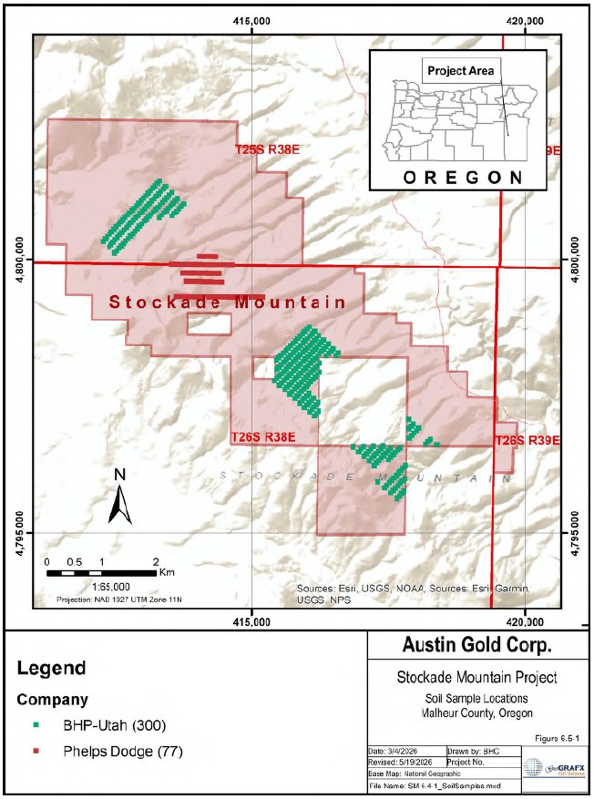
Figure 6.5-1 Soil Sample Locations
| NI 43-101 Technical Report Stockade Mountain Project | Page: 52 | |
| Malheur County, Oregon, USA | ||
Between 1989 and 2017, over 1,151 rock chip samples were collected on the Stockade Mountain Property (554 samples) and surrounding areas by Carlin Gold, BHP-Utah, Phelps Dodge, Placer Dome, The Electrum Group and La Cuesta International. Figure 6.5-2 shows the compilation of the rock chip samples taken by the different companies on the Property.
| NI 43-101 Technical Report Stockade Mountain Project | Page: 53 | |
| Malheur County, Oregon, USA | ||
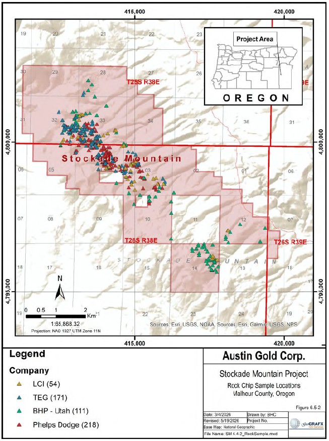
Figure 6.5-2 Rock Chip Sample Locations
| NI 43-101 Technical Report Stockade Mountain Project | Page: 54 | |
| Malheur County, Oregon, USA | ||
The surface sample summary included in Table 6-2 Summary of Surface Samples refers to the number of samples collected based on reference from company reporting. The number of samples included in the Austin Gold Property is based on the number of samples with known sample locations. Discrepancies can occur.
Table 6-2 Summary of Surface Samples
| Company | Date | Sample | Total | Austin Gold | Assay Lab |
| Type | Samples | Property | |||
| Samples | |||||
| Carlin Gold | 1989-1992 | Rock Chip | unknown | unknown | unknown |
| BHP - Utah | 1990 | Rock Chip | 42 | 54 | Chemex |
| International | |||||
| 1990 | 278 | 57 | Bondar-Clegg | ||
| 1990 | Soil | 1,065 | 300 | GSI | |
| 1990 | Bleg | 36 | unknown | American Assay | |
| Labs | |||||
| Phelps Dodge | 1990 | Rock Chip | 405 | 218 | Bondar-Clegg |
| 1990 | Soil | 75 | 77 | Bondar-Clegg | |
| Placer Dome | 1993 | Rock Chip | 68 | unknown | Bondar-Clegg |
| LCI | 2014-2016 | Rock Chip | 128 | 54 | ALS Minerals |
| 2014-2016 | Stream Sed | 3 | unknown | ALS Minerals | |
| TEG | 2016-2017 | Rock Chip | 230 | 171 | ALS Minerals |
| TOTAL |
The inventory of surface sampling is incomplete. Company reports refer to samples with no known locations, assay certificates contain samples with no corresponding sample locations, maps show sample locations with no associated assay certificates, and several historical maps contain sample locations with no associated sample IDs.
6.5.1 1989 - 1992 Carlin Gold
Carlin Gold collected rock chip samples within their claim block from 1989 through 1992. There is reference to the sampling program in the historical company reports, but no other information is available.
6.5.2 1990 BHP - Utah International
The following summary of surface sampling by BHP - Utah international was derived largely from (Spatz, 1991) with additional details listed below.
A total of 320 rock chip samples were collected across the broader area, including 111 samples on the Property, consisting primarily of outcrop samples with some float included. The initial 42 samples were analyzed by Chemex for 32 elements using ICP. Gold analyses were performed by fire assay with AA finish. The remaining samples were analyzed for gold at a 5 ppb detection limit by Bondar-Clegg. ·
An extensive soil survey totaling 1,065 samples was conducted across the broader area, including 300 samples on the Austin Gold claims, on a 400' × 200' grid (500' × 200' in places). A base line was surveyed by a professional contract surveyor. The soil survey was preceded by a 100' x 100' orientation survey which involved sampling different soil horizons and analyzing separate mesh sizes down to -200. Based on the orientation study, -80 mesh size separates were analyzed. Samples were collected well into the B horizon where possible, typically at about a 14" depth. Soil analyses were performed by Geochemical Services Inc. (GSI) on 30 gram samples using a strong oxidizing acid and a selective organic extraction. Ultra-trace gold with a detection limit of 0.2 ppb was obtained by graphite furnace AA and 14 other elements by ICP.
| NI 43-101 Technical Report Stockade Mountain Project | Page: 55 | |
| Malheur County, Oregon, USA | ||
Finally, a bulk-leach, extractable gold (BLEGS) survey, involving 36 samples, was also conducted. Stream sediment samples were screened to 4 lbs. of -2 mm in the field and bulk-leached with cyanide for 24 hours by American Assay Labs. Gold was analyzed by AA.
Sample location maps and assay certificates are available for the rock chip and soil sampling program.
6.5.3 1990 - 1992 Phelps Dodge
Several hundred rock and soil samples were analyzed for Au, Ag, base metals and trace elements.
Four hundred five rock chip samples were collected on the Property (218 samples) and surrounding areas, and were analyzed for Au, Ag, As, Sb, Hg, Cu, Pb, Zn and Mo. Seventy-five soil samples on 200- foot spacings in five lines were also collected and analyzed (Canby, 1991). Assay certificates from Bondar Clegg are available for the sampling program, as is a sample location map.
6.5.4 1992 Newmont Exploration
Newmont reviewed the Property as a submittal from Carlin Gold in 1992. A single Jerome mercury line 10,000 feet long was run from the rhyolite dome in Section 4 southeast to the dome in Section 11. Anomalous mercury was identified near the rhyolite domes.
6.5.5 1993 Placer Dome
Sixty-eight rock samples were analyzed for Au, Ag, base metals and trace elements. Rock sample geochemistry and descriptions are included in the data package. No information is available on sample locations.
6.5.6 2014-2016 La Cuesta International
Between 2014 and 2016, La Cuesta International (LCI) collected 128 rock chips in the Stockade Mountain area (Hillemeyer & Durning, Sept 2014), (Hillemeyer & Durning, Sample Designations and Summary of the 3rd Quarter 2015 Reconnaissance Exploration Program, Oregon and Nevada, March 2016), (Hillemeyer & Durning, September 2016).
6.5.7 2016-2020 The Electrum Group
Between 2016 and 2017, 230 samples were taken during outcrop mapping by L. Buchanan, with field assistance by X. Buchanan (Buchanan & Buchanan, October 2017). The samples were sent to ALS laboratory in Reno, Nevada for analysis.
6.6 Surface Geochemistry
6.6.1 2020 P2 Gold
Between 1989 and 1993, over 377 soil samples were collected on the Stockade Mountain Property by BHP-Utah and Phelps Dodge. Figure 6.6-1 shows the compilation of gold in soil samples taken on the Stockade Mountain Project.
| NI 43-101 Technical Report Stockade Mountain Project | Page: 56 | |
| Malheur County, Oregon, USA | ||
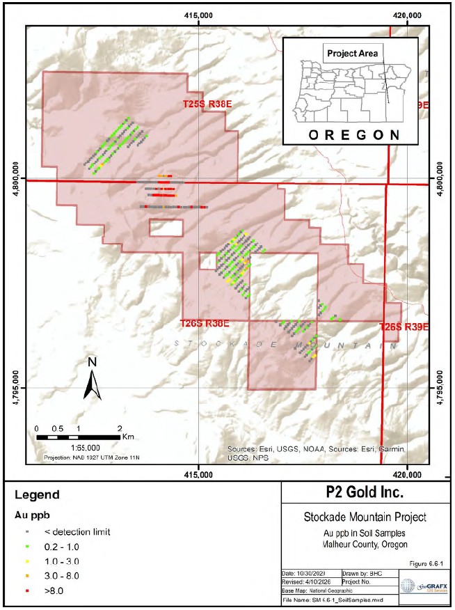
Figure 6.6-1 Compilation of Gold in Soil Samples
| NI 43-101 Technical Report Stockade Mountain Project | Page: 57 | |
| Malheur County, Oregon, USA | ||
Between 1989 and 1993, more than 554 rock chip samples were collected on the Stockade Mountain Property by Carlin Gold, BHP-Utah, Phelps Dodge, Placer Dome, The Electrum Group, and La Cuesta International.
Figure 6.6-2 shows the compilation of gold values from rock chip samples collected on the Stockade Mountain Project.
| NI 43-101 Technical Report Stockade Mountain Project | Page: 58 | |
| Malheur County, Oregon, USA | ||
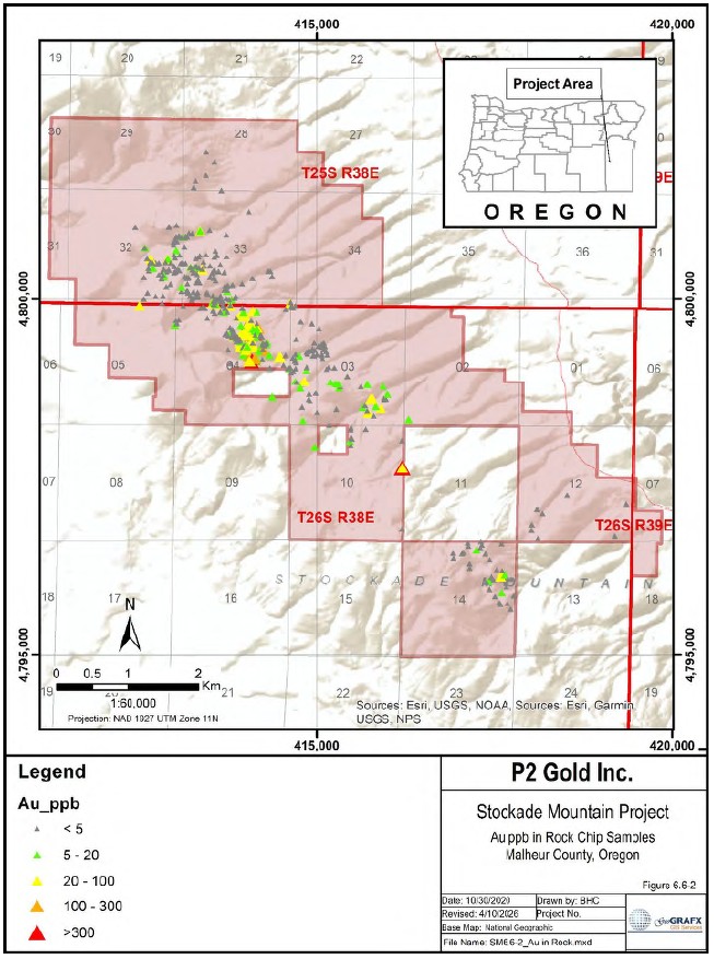
Figure 6.6-2 Compilation of Gold in Rock Chip Samples
| NI 43-101 Technical Report Stockade Mountain Project | Page: 59 | |
| Malheur County, Oregon, USA | ||
6.7 Geophysics
6.7.1 1990 BHP- Utah International
A VLF survey was performed over the hot spring area where the most concentrated drilling was conducted. Six NE-SW lines, 2,800 feet long, were resurveyed coincident with the soil grid, and measurements were taken every 50 feet. In addition, VLF data were collected along three·1,800 foot long NW-SE lines (Spatz, 1991).
6.7.2 1993 Placer Dome
A geophysical VLF-R resistivity survey was conducted on a 1,600' x 2,400' grid with 200 foot line spacing and 50 foot station spacings on opalite-chalcedony mineralization in the SE quarter of Section 32 and the SW quarter of Section 33. Several isolated reconnaissance lines also were evaluated.
6.7.3 2021 P2 Gold
6.7.3.1 AeroMagnetic-Radiometric Survey
P2 Gold contracted EDCON-PRJ to conduct an aeromagnetic-radiometric survey over the Stockade Mountain Property in October 2020. Fritz Geophysics subsequently completed an interpretation of the survey data with the objective of mapping host rock types and structural features and evaluating whether the data indicated potential exploration targets.
According to Fritz (2020) Airborne radiometric data reflects the very near surface, probably less that the first half meter. Figure 6.7-1 shown below contains the interpretation of the rock types. Radiometric Rock types are represented by RT#1-RT#4, structure is indicated by dashed blue lines, bedding by dashed green lines and remnant magnet lows in blue.
| NI 43-101 Technical Report Stockade Mountain Project | Page: 60 | |
| Malheur County, Oregon, USA | ||
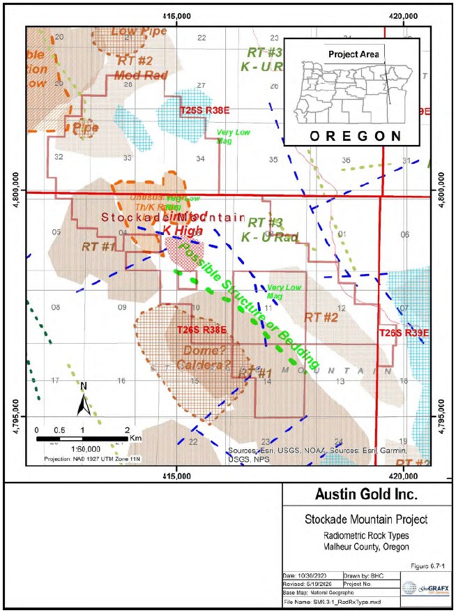
Figure 6.7-1 Radiometric Rock Type Interpretation
| NI 43-101 Technical Report Stockade Mountain Project | Page: 61 | |
| Malheur County, Oregon, USA | ||
6.7.3.2 Gradient IP-Resistivity Survey
In August 2021, Fritz Geophysics designed, supervised, and interpreted a Gradient Array IP-Resistivity survey over prospects and mapped vein systems in the Stockade Mountain Project area in central Oregon at the request of P2 Gold. The objective of the survey was to determine whether IP and resistivity methods could detect known mineralization and identify additional exploration targets.
According to Fritz (2021), "the resistivity data shows a limited range of values suggesting a reasonably consistent rock type. This is consistent with the aeromagnetic and radiometric data". Two possible structures are suggested by these data, as shown in Figure 6.7-2. However, this has been refuted by Austin Gold's recent CSAMT survey.
The IP data was quite noisy with low signal levels. No significant responses are noted in the very scattered responses.
| NI 43-101 Technical Report Stockade Mountain Project | Page: 62 | |
| Malheur County, Oregon, USA | ||
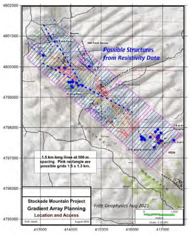
Figure 6.7-2 Contoured Resistivity Data GIP Survey, with Interpretation
6.8 Drilling
Between 1990 and 1993, available records show 57 rotary reverse-circulation drill holes totaling 23,130 feet were drilled in the Stockade Mountain area (Austin Gold's claims and adjacent private property) to explore and define mineralization. Details on the drilling programs undertaken on the Property by previous companies are included in Section 10: Drilling of this report.
| NI 43-101 Technical Report Stockade Mountain Project | Page: 63 | |
| Malheur County, Oregon, USA | ||
Table 6-3 Summary of Holes Drilled at Stockade Mountain Project
| Company | Date | Number | Feet | Type |
| Holes | ||||
| BHP - Utah International | 1990 | 18 | 6,375 | Reverse Circ |
| Phelps Dodge | 1990 | 13 | 5,385 | Reverse Circ |
| 1991 | 9 | 4,170 | Reverse Circ | |
| Carlin Gold | 1992 | 7 | 2,870 | Reverse Circ |
| Placer Dome | 1993 | 10 | 4,330 | Reverse Circ |
| TOTAL | 57 | 23,130 |
The drill hole inventory is incomplete. Company reports refer to drill holes with no known locations, drilling programs in which not all holes were recorded, and assay results associated with holes lacking corresponding location information. Additional drill holes with no clear reference to their origin were also identified on several historical maps.
6.8.1 1990 BHP - Utah International
Eighteen drill holes were completed ranging in depth from 220 feet to 500 feet, averaging 344 feet, and totaling 6,205 feet. Both 5-foot and 20-foot splits were collected. The 20-foot splits were analyzed initially by American Assay for Au and 30 other elements. Intervals anomalous in Au were reanalyzed at 5-foot intervals (Spatz, 1991).
Drill hole location maps, drill logs, and assay certificates are available for this data set.
6.8.2 1990 - 1992 Phelps Dodge
Twenty-two reverse circulation rotary holes with a total of 9,555 feet were drilled by Phelps Dodge from 1990 to 1991.
In early May 1990, a six-hole reverse circulation drilling program was completed, targeting areas of the strongest geochemistry, alteration, and width of fractured zones along structure. Results from this early drilling program and more detailed mapping and sampling were used to target seven additional holes which were completed in early October 1990 (Canby, 1991). Nine additional holes were drilled in 1991 for a total of 4,170 feet. Drill Hole Location Map, summary of drilling results, assay certificates, and schematic drill logs having both gold and trace element results are included in the data set.
6.8.3 1992 Carlin Gold
In 1992, six reverse circulation holes were drilled in a fence pattern in opalite-chalcedony mineralization in the SE quarter of Section 32 and one hole was drilled to evaluate covered mineralization in the NW quarter of Section 33 for a total of 2,870 feet (Mejstrick & Dodd, December 1993). Drill logs and assay certificates are available for these holes. Drill hole locations for the Carlin Gold holes were included on the Placer Dome maps.
6.8.4 1993 Placer Dome
Ten reverse circulation holes were drilled for a total of 4,330 feet. Location map, assay certificates and drill logs are included in the data package.
| NI 43-101 Technical Report Stockade Mountain Project | Page: 64 | |
| Malheur County, Oregon, USA | ||
6.9 Metallurgical Sampling
6.9.1 1990 - 1992 Phelps Dodge
Results from cyanide shake tests taken from 1990 drilling are erratic but generally show no indication of encapsulation or refractory mineralization. Possible nugget effect was indicated by high recoveries in some samples.
6.9.2 1993 Placer Dome
Preliminary leachability tests on 49 selected drill samples indicate that at least a portion of the gold is cyanide leachable. Recoveries varied from an average of 65% (-150 mesh, 2 hour agitation) to 80% (-200 mesh, 24 hour agitation) (Mejstrick & Dodd, December 1993).
| NI 43-101 Technical Report Stockade Mountain Project | Page: 65 | |
| Malheur County, Oregon, USA | ||
7 GEOLOGIC SETTING AND MINERALIZATION
7.1 Regional Geology
The following discussion of the regional geologic setting of the Owyhee Uplands is derived largely from Corcoran (1969) with additional information as cited.
The Stockade Mountain Project area lies within the Owyhee Upland physiographic province of eastern Oregon as defined by Dicken (1950). The Owyhee Upland shown in Figure 7.1-1 is essentially a plateau region developed on several widespread extrusive basaltic, andesitic, and rhyolitic sheets with associated pyroclastic and sedimentary rocks of middle to late Cenozoic age. The varied landscape includes deep gorges where the major streams have cut through resistant lava and ash flows into softer, more easily eroded sediments and tuffs, open basins underlain by thick sequences of continental beds, and broad upland regions capped by thin sheets of lava or welded tuff. Elevations range from 2,230 feet on the Snake River to 5,000 - 6,000 feet along the western and southern borders of the province.
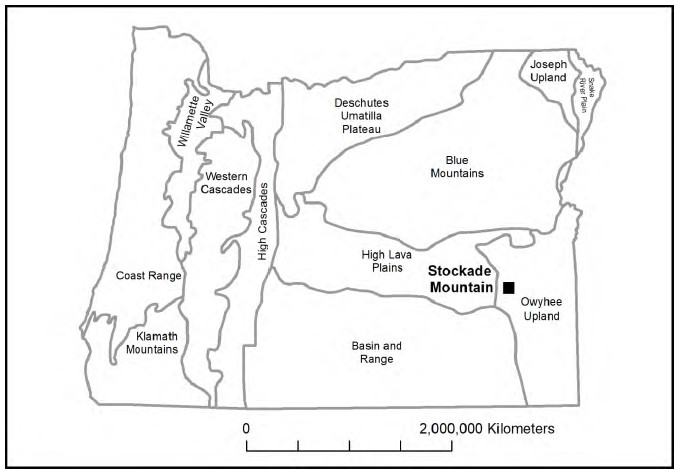
Figure 7.1-1 Geomorphology of Oregon (after Dicken 1950)
The province merges with the Basin - Range and High Lava Plains to the south and west, and some of the geologic and geomorphic features characteristic of these provinces extend into the Owyhee Upland. Extensions of the block fault mountains of the Basin - Range in the Owyhee Upland are neither as large nor as well-defined separate blocks as those to the southwest. The established drainage pattern and more mature topography distinguish the Owyhee Upland from the geologically younger plains regions both to the west and east. The southern Blue Mountains, which are underlain by intensely deformed pre-Tertiary marine sedimentary rocks and metavolcanic rocks, mark the northern boundary of the Owyhee Upland. The province extends eastward to the broad Snake River Basin, which has been filled with several thousand feet of upper Tertiary and Quaternary terrestrial sediments and lavas.
| NI 43-101 Technical Report Stockade Mountain Project | Page: 66 | |
| Malheur County, Oregon, USA | ||
No pre-Tertiary rocks are exposed within the province, although marine sedimentary beds of Mesozoic age or older, which crop out to the north in the Blue Mountains and dip southerly, presumably lie below the Tertiary cover. By the close of the Mesozoic era in Oregon, the seas had retreated from the region east of the Cascade Range, and all the Cenozoic sediments are continental deposits.
7.1.1 Geology
The following discussion of the geology of the Owyhee Uplands is based largely on Foord and Luessen (1987) with additional information as cited.
The Owyhee Upland is characterized by rhyolite- basalt volcanism similar to the Snake River Plain and Great Basin provinces (Hart, 1985; Leeman, 1982). The plateau is underlain by Miocene rhyolitic rocks that range from 13.8 to 9.4 million years old (Ekren and others, 1984). The rhyolitic rocks, which were originally mapped as, and are correlative to, the Idavada Volcanics, are predominantly densely welded rhyolitic ash-flow tuffs as defined by Malde and Powers (1962, p. 1204).
The rhyolites are overlain by tuffaceous sediments (unit Tts) and by basalts, which erupted between 10 and 6 million years ago and cap the Owyhee Upland (Hart and others, 1984). These basalts were previously mapped as Banbury Basalt on all known published maps of the region (Ekren and others, 1981, 1984; Stewart and Carlson, 1976; Hope and Coats, 1976; Coats, 1968; and others). The uppermost basalt flows, called "rim basalts" (unit Tbr), distinctive cliff formers at the lip of the upper plateau, apparently issued from shield volcanoes in the region. The shield volcanoes have slopes of only a few degrees and rise a few hundred feet above the surrounding basaltic plateau. Many thin basalt flows exposed below the rim basalt are called "canyon basalt" (unit Tbc).
7.1.2 Structure
The Miocene sediments and lavas in the Owyhee Upland have been moderately deformed and broken into a number of separate fault blocks. These blocks are not as large nor as continuous as those in the adjacent Basin and Range province, and the amount of movement along any particular fault has not been as great. Pliocene sediments and lavas fill many of the troughs produced by the post-Miocene deformation. Rocks of the Idaho Group (Pliocene and Pleistocene) also have been deformed, but the amount of displacement in most places is considerably less than in the older rocks. Pleistocene rocks of the Rome basin are only slightly deformed.
The well-defined northeast trend of the faults in the Basin and Range province is seen only in a few places in the Owyhee Upland, mostly in the southern part of the province. The pattern tends to die out to the north and east, and in most of the Owyhee Upland the predominant trends are northerly or northwesterly. The change in direction of the fault zone may reflect a deep - seated change in the subcrustal tectonic pattern in this region.
The northwest - trending Western Snake River Plain (WSRP) is a major structural feature, the development of which began at least by middle Miocene time. Older Tertiary units cropping out on both sides of the WSRP show considerable block faulting and indicate that it is a broad, depressed region filled with later Tertiary and Quaternary sedimentary and volcanic rocks.
Further west, the Oregon-Idaho Graben (Cummings, Evans, Ferns, & Lees, May 2000) is a broad north- south-trending synvolcanic graben within the middle Miocene rift system that extends 1,100 km from southern Nevada to southeastern Washington. The Grassy Mountain and Quartz Mountain gold/silver deposits occur along faults of the Oregon-Idaho Graben, and Stockade Mountain lies just southwest of the southwestern-most mapped faults of this feature.
| NI 43-101 Technical Report Stockade Mountain Project | Page: 67 | |
| Malheur County, Oregon, USA | ||
Like the rest of the Great Basin, the Owyhee Upland is an area of broad uplift, as shown by the youthful topography in the main river canyons. Unlike the typical Basin and Range structure of youthful linear basins and fault block mountains, the north- to northwest-trending pattern of normal faults is subdued to missing in most of this area. As noted previously, the northwestern Basin and Range, including the Owyhee Uplands during late Cenozoic time is characterized by extensional tectonics, a thin crust, high heat flow, and bimodal rhyolite-basalt volcanic rocks.
7.1.3 Mineralization
Southeastern and south-central Oregon contains a number of Mid-Miocene paleo hot springs/geothermal systems that formed economic or near-economic low-sulfidation gold-silver deposits, or which are favorable for the discovery of such deposits. Well-known occurrences include the Grassy Mountain deposit south of Vale, currently being advanced toward production by Paramount Gold Nevada Corp., as well as Quartz Mountain (Malheur County) and Quartz Mountain (Lake County), both of which have NI 43-101 compliant resources. Additional epithermal prospects in the Owyhee Uplands with characteristics similar to Stockade Mountain include the Frost Project and Red Butte. Selected deposits and prospects are shown in Figure 23-1, and those considered adjacent properties are discussed in Section 23. Other less well-known occurrences, such as Stockade Mountain, are receiving renewed exploration attention as the search for high-grade deposits expands from Nevada into Oregon and Idaho.
7.2 Local Geology
In 1991, the U.S. Geological Survey published a 1:500,000 scale map of the state of Oregon (Walker & MacLeod, 1991). The map is available in paper, GIS format, and via the web, and provides the basis for the regional and local geology referenced in this report. For the purposes of this discussion, "local geology" refers to geologic features within approximately 5 to 10 miles of the project area, as shown in Figure 7.2-1.
| NI 43-101 Technical Report Stockade Mountain Project | Page: 68 | |
| Malheur County, Oregon, USA | ||
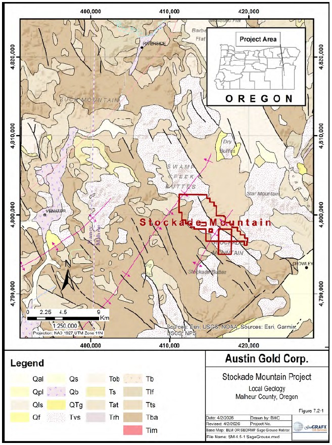
Figure 7.2-1 Local Geology
| NI 43-101 Technical Report Stockade Mountain Project | Page: 69 | |
| Malheur County, Oregon, USA | ||
7.2.1 Geology
The oldest rocks in the area surrounding the Stockade Mountain Project, shown in Figure 7.2-1, are Miocene lava flows and breccia of porphyritic basalt and andesite (Tba). These are overlain by moderately well indurated lacustrine and fluvial deposits of tuffaceous sedimentary rocks, tuffs, pumicites, and silicic flows (Tts) followed by deposition of poorly to moderately consolidated bedded silicic ash and pumicite, diatomite, tuffaceous sedimentary rocks, minor mudflow deposits and some coarse epiclastic deposits (Tlf).
Volcanism dating approximately 14-16Ma in the central and southern part of the Owyhee Uplands saw the deposition of ash-flow tuff, lava flows, flow breccias, and resurgent domal masses of rhyolitic, rhyodacitic and dacitic composition in the McDermitt caldera area (Trh). These were overlain by ash- flow and air flow tuff mostly of rhyolitic and rhyodacitic composition. Volcanism was followed by regional subsidence and punctuated by quiet periods with freshwater basins as evidenced by deposition of lacustrine tuffaceous sedimentary rocks dating late Miocene to Early Pliocene (Tob). Basaltic volcanism occurred throughout this sequence (Tob) and is thought to have provided the heat source for the partial melting of crustal materials, leading to the generation of the silicic magmas (Roche, 1987).
The final phase of volcanism in the sequence was the introduction of plugs and domal complexes of rhyolitic, rhyodacitic, and dacitic composition, including related near-vent flows, flow breccia, and deposits of obsidian, perlite, and pumice.
Additional detail on the lithology in the district can be found in Table 7-1 which is compiled from the legend of the Geologic Map of Oregon shown in Figure 7.2-1.
Table 7-1 Lithologic Description of Geologic Units in the Stockade Mountain Region
| Lith Symbol |
Name | Description | Age |
| Qal | Alluvial deposits | Sand, gravel, and silt forming flood plains and filling channels of present streams. In places includes talus and slope wash. Locally includes soils containing abundant organic material, and thin peat beds | Holocene |
| Qpl | Playa deposits | Clay, silt, sand, and some evaporites | Holocene |
| Qf | Fanglomerate | Poorly sorted and poorly stratified alluvial fan debris, slope wash, colluvium, and talus; composed mostly of silt and fragments of basalt, basaltic andesite, and andesite. In places includes small areas of pediment gravels and colluvium | Pleistocene to Holocene |
| Qs | Lacustrine and fluvial sedimentary rocks | Unconsolidated to semiconsolidated lacustrine clay, silt, sand, and gravel; in places includes mudflow and fluvial deposits and discontinuous layers of peat. Includes older alluvium and related deposits of Piper (1942), Willamette Silt (Allison, 1953; Wells and Peck, 1961), alluvial silt, sand, and gravel that form terrace deposits of Wells and others (1983), and Gresham and Estacada Formations of Trimble (1963). Includes deltaic gravel and sand and gravel bars, in pluvial lake basins in southeastern part of map area. In Rome Basin, includes discontinuous layers of poorly consolidated conglomerate characterized by well-rounded, commonly polished pebbles of chert and pebbles and cobbles of quartzite. In places, mollusks or vertebrate fossils indicating Pleistocene age; mostly deposits of late Pleistocene age but locally includes some deposits of early Holocene age. Includes Touchet Beds of Flint (1938), deposits of valley terraces of Newcomb (1965), and, in southeast Oregon, basin-filling deposits that incorporate Mazama ash deposits (Qma, Qmp) in the youngest layers | Pleistocene |
| QTg | Terrace gravels | Unconsolidated to poorly consolidated, poorly sorted gravels and bouldery soil above modern stream channels. In Cascade Range, clasts mostly basalt and andesite. Includes some glacial outwash deposits. In Eastern Oregon, commonly cemented by caliche | Pliocene to Pleistocene |
| NI 43-101 Technical Report Stockade Mountain Project | Page: 70 | |
| Malheur County, Oregon, USA | ||
| Tvs | Silicic vent rocks | Plugs and domal complexes of rhyolitic, rhyodacitic, and dacitic composition; includes related near-vent flows, flow breccia, and deposits of obsidian, perlite, and pumice. Locally includes resurgent domes related to caldera complexes. In southeast Oregon, many domal complexes younger than 11 Ma exhibit a well-defined southeast to northwest age progression (Walker, 1974; MacLeod and others, 1976) from about 11 Ma to less than 1 Ma | Eocene to Pliocene |
| Tob | Olivine basalt | Thin, commonly open-textured (diktytaxitic), subophitic to intergranular olivine basalt flows, intercalated with and grades laterally through palagonite breccia and tuff into tuffaceous sedimentary rocks (unit Ts). In places includes flows of platy olivine andesite or basaltic andesite. Several potassium-argon ages ranging from about 4 to 7 Ma indicate unit is mostly of early Pliocene and late Miocene age. Includes Shumuray Ranch Basalt and Antelope Flat Basalt of Kittleman and others (1965), Grassy Mountain Basalt of Corcoran and others (1962), Drinkwater Basalt of Bowen and others (1963), basalt formerly assigned to Danforth Formation by Piper and others (1939) (see Walker, 1979), Hayes Butte Basalt of Hampton (1964), Pliocene and upper Miocene basalt flows capping and interstratified with the Madras (or Deschutes) Formation, and basalt flows interstratified in the Dalles Formation of Newcomb (1966; 1969) | Miocene to Pliocene |
| Ts | Tuffaceous sedimentary rocks and tuff | Semiconsolidated to well-consolidated mostly lacustrine tuffaceous sandstone, siltstone, mudstone, concretionary claystone, conglomerate, pumicite, diatomite, air-fall and water-deposited vitric ash, palagonitic tuff and tuff breccia, and fluvial sandstone and conglomerate. Palagonitic tuff and breccia grade laterally into altered and unaltered basalt flows of unit Tob. In places includes layers of fluvial conglomerate and, in parts of the Deschutes-Umatilla Plateau, extensive deposits of fanglomerate composed mostly of Miocene basalt debris and silt. Also includes thin, welded and nonwelded ash-flow tuffs. Vertebrate and plant fossils indicate rocks of unit are mostly of Clarendonian and Hemphillian (late Miocene and Pliocene) age. Potassium-argon ages on interbedded basalt flows and ash-flow tuffs range from about 4 to 10 Ma. Includes the Drewsey Formation of Shotwell and others (1963); sedimentary parts of the Rattlesnake Formation of Brown and Thayer (1966); an interstratified ash-flow tuff has been radiometrically dated by potassium-argon methods at about 6.6 Ma (see Fiebelkorn and others, 1983); Bully Creek Formation of Kittleman and others (1967); Dalles Formation of Newcomb (1966, 1969); Shutler Formation of Hodge (1932), McKay beds of Hogenson (1964) and Newcomb (1966) (see also Shotwell, 1956); Kern Basin Formation of Corcoran and others (1962); Rome beds of Baldwin (1976); parts of the (now obsolete) Danforth Formation of Piper and others (1939), Idaho Group of Malde and Powers (1962), Thousand Creek Beds of Merriam (1910); the Madras (or Deschutes) Formation, the "Simtustus formation" of Smith (1984), and the Yonna Formation (Newcomb, 1958). In areas west of Cascade crest, includes the Sandy River Mudstone and the Troutdale Formation of Trimble (1963) and the lower Pliocene Helvetia Formation of Schlicker and Deacon (1967) | Miocene to Pliocene |
| Tat | Silicic ash-flow tuff | Ash-flow tuff and associated pumiceous air-fall tuff mostly of rhyolitic and rhyodacitic composition; includes minor tuffaceous sedimentary rocks. Grades laterally through less-densely welded tuff to nonwelded ash-flow tuff and interlayered tuffaceous sediments of unit Ts. Potassium-argon ages (Greene and others, 1972; Parker and Armstrong, 1972; Walker, 1979; McKee and others, 1976) on several different ash-flow tuffs included in unit range from about 4 to 10 Ma; although most ages are in the range of 6 to 9 Ma. Includes the Devine Canyon, Prater Creek, and Rattlesnake Ash-flow Tuffs (Walker, 1979), originally considered a part of the (now obsolete) Danforth Formation of Piper and others (1939), and the Rattlesnake Formation and the volcanic and fluvial deposits (undivided) and marginal facies of the Columbia River Group (undivided) of Brown and Thayer (1966). Also includes the welded soda--rhyolite tuff breccia of Dickinson and Vigrass (1965) in the Suplee-Izee area, the upper Miocene or lower Pliocene welded tuff of Prostka (1962; 1967) in the Baker area. "Welded ash-flow tuff" of Swanson (1969a) and the Pliocene Peyerl Tuff (Hampton, 1964) west of Fort Rock Valley, dated at about 4.5 Ma (McKee and others, 1976) | Late Miocene to Early Pliocene |
| NI 43-101 Technical Report Stockade Mountain Project | Page: 71 | |
| Malheur County, Oregon, USA | ||
| Trh | Rhyolite and dacite | Ash-flow tuff, lava flows, pumice-lapilli tuff, coarse pumicite, flow breccia, and domal complexes of rhyolitic, rhyodacitic, and dacitic composition; in places includes peralkaline rhyolite and some andesite and andesite breccia. Locally porphyritic with phenocrysts of alkali feldspar, plagioclase, and minor augite, ferro-hedenbergite, hornblende, hypersthene, or biotite. Commonly flow banded; locally glassy. Many of the ash--flow tuffs exhibit flow features and only obscure vitro-clastic textures. In places includes interlayers of silicic volcaniclastic rocks and tuffaceous sedimentary rocks. Includes rhyolite at Owyhee Dam, Jump Creek Rhyolite, and Littlefield Rhyolite, all of Kittleman and others (1965); Dooley Rhyolite Breccia of Gilluly (1937), radiometrically dated at 14.7 ñ 0.4 Ma by potassium-argon methods (Fiebelkorn and others, 1983); resurgent domal masses in McDermitt caldera area; and extensive unnamed flows and ash-flow tuffs in the central and southern part of the Owyhee Upland. Also includes isolated masses of dacitic and rhyodacitic flows, breccia, and ash-flow tuff along eastern slope of Cascade Range that are lapped by flows and sediments of the Madras (or Deschutes) Formation. Potassium-argon ages on rocks in unit from southeast Oregon range from about 13 to 16 Ma; lenses of interbedded tuffaceous sedimentary rocks locally contain a Miocene (Barstovian) vertebrate fauna Poorly to moderately consolidated, bedded silicic ash and pumicite, diatomite, tuffaceous sedimentary rocks, minor mudflow deposits, and some coarse epiclastic deposits. Vitroclastic material in some beds diagenetically altered to zeolites, secondary silica minerals, and clay minerals. In eastern Blue Mountains province vertebrate fossils indicate unit is mostly of late Miocene (Clarendonian) age but may also include some rocks of middle Miocene (Barstovian) age. In High Lava Plains and northern Owyhee Upland provinces, vertebrate fossils indicate unit is partly late Miocene (Clarendonian) but probably is mostly middle Miocene (Barstovian) in age. Interfingers and grades laterally into unit Tmb. Includes lake and stream sediments and tuffaceous lake and stream deposits of Prostka (1962, 1967), Deer Butte Formation of Corcoran and others (1962) and Kittleman and others (1967), Juntura Formation of Shotwell and others (1963), some rocks originally assigned to the lower part of the (now obsolete) Danforth Formation of Piper and others (1939), and interbeds in upper part of Columbia River Basalt Group in northern Wallowa County Moderately well indurated lacustrine and fluvial (flood-plain) deposits of tuff, pumicite, palagonite tuff, and lesser siltstone, arkosic sandstone, and pebble and cobble conglomerate. Locally contains some lignite beds. Former glass in silicic vitroclastic debris commonly crystallized and altered to secondary silica minerals, alkali feldspar, zeolites, and clay minerals. Contains some welded and nonwelded ash-flow tuffs, and minor rhyolite flows. Widespread and abundant vertebrate fossils and minor plant fossils indicate that most of unit is of middle Miocene (Barstovian) age; parts of unit between Goose Lake and Warner Valley may include rocks of early Miocene age. Locally interlayered with and locally overlies basalt and andesite flows of unit Tmb. Overlies and locally interfingers with Picture Gorge Basalt (Thayer and Brown, 1966) and with Miocene basalt south of Prineville. Includes Mascall Formation of Merriam (1901), Sucker (Succor) Creek Formation of Corcoran and others (1962) and Kittleman and others (1967), Drip Spring Formation of Kittleman and others (1965, 1967), Trout Creek Formation of Smith (1926), and "rocks of Miocene age" of Malde and Powers (1962) in the southern Owyhee Upland province. In southeast Oregon, some of these rocks represent caldera and moat-fill deposits | Miocene to Pliocene |
| Tlf | Lacustrine and fluvial deposits | Miocene | |
| Tts | Tuffaceous sedimentary rocks, tuffs, pumicites, and silicic flows | Miocene |
| NI 43-101 Technical Report Stockade Mountain Project | Page: 72 | |
| Malheur County, Oregon, USA | ||
| Tba | Basalt and andesite | Lava flows and breccia of aphyric and plagioclase porphyritic basalt and aphyric andesite; locally includes flow breccia, peperite, some palagonite tuff and breccia, and minor silicic ash-flow tuff and interbeds of tuffaceous sedimentary rocks. In Basin and Range and Owyhee Upland provinces unit grades upward into more silicic, andesitic, and quartz latitic flows and flow breccia, as well as some interbedded tuffs and ash-flow tuffs; also, in this region includes aphyric and highly porphyritic, plagioclase-rich basalt. Interfingers with and grades laterally into units Tit and Tts. Commonly contains montmorillonite clays, zeolites, calcite, and secondary silica minerals as alteration products on fractures and in pore spaces. Age, mostly middle Miocene, but includes some rocks of early Miocene age based on vertebrate fossils from related sedimentary units and on potassium-argon ages that range from about 13 Ma to about 19 Ma; most isotopic ages are about 13 to 16 Ma. Includes Steens Basalt (Steens Mountain Basalt of Fuller, 1931) Owyhee Basalt of Corcoran and others (1962) and Kittleman and others (1967), Hunter Creek Basalt and "unnamed igneous complex" of Kittleman and others (1965, 1967), and flows of Prineville chemical type (Uppuluri, 1974; Swanson and others, 1979), which previously were considered part of the Columbia River Basalt Group (Swanson, 1969a) | Miocene |
7.2.2 Mineralization
No other mineralized areas are known to occur within the immediate vicinity of the Stockade Mountain Project.
7.3 Property Geology and Mineralization
Stockade Mountain exhibits a large classic gold- and silver-bearing low-sulfidation hydrothermal system associated with rhyolite intrusion and doming that formed along a major NW-trending structural corridor. The hydrothermal system is up to 4 miles long NW-SE and is up to a mile in width. Gold/silver and high-level mercury mineralization at Stockade is associated with widespread silicification and argillization in a near-surface paleo-hot springs environment. This hydrothermal alteration and mineralization formed in and around rhyolite domes that have intruded gently dipping felsic tuffs. Geological characteristics are similar to those at Paramount's nearby Grassy Mountain gold deposit or Quartz Mountain, both in southeastern Oregon. Those projects are discussed in more detail in Section 23: Adjacent Properties.
Erosion into the hydrothermal system has been minimal, resulting in the local exposure of probable hydrothermal craters and vents that indicate the paleosurface at the time of hot springs activity. Gold and silver, along with associated elements arsenic, antimony, and mercury, are all anomalous at the surface, however, historical and Austin Gold drilling shows that gold and silver values, and their extent, increase significantly with depth below the paleosurface.
A significant limitation to fully understanding the geology at Stockade Mountain is a lack of sufficient outcrop from which to interpret lithologic contacts and structure. Because of this, Austin Gold has not yet attempted to put together a detailed geological map. Within mineralized zones, the best outcrops are those where the rocks are "silicified" (opal/chalcedony replaced). Additional information about lithologies is derived from historical rotary reverse-circulation drill hole logs, however these are often vague due to the nature of the drilling method. Diamond "core" drilling by Austin Gold (the first company to use this method), confirms the general lithological understanding of the Property, and, importantly, confirms that the gold mineralization drilled by prior companies is indeed a classic high- level stockworks/breccia zone.
| NI 43-101 Technical Report Stockade Mountain Project | Page: 73 | |
| Malheur County, Oregon, USA | ||
Earlier efforts of geological mapping were conducted by BHP-Utah International (1990), Phelps Dodge (1990-92), and Placer Dome (1993). The Electrum Group compiled the geology in 2016-2017 and completed detailed mapping in favorable target areas. The following discussion of the Stockade Mountain geology and mineralization is derived partially from Buchanan (2017) final report with additional information as cited.
7.3.1 Geology
Stockade Mountain is comprised of weakly to strongly welded rhyolitic ash flow sheets and tuff units that were intruded by domes of fine-grained porphyritic rhyolite. The domes rose up a central vent and formed discontinuous, broken layers of vitrophyre near the upper and frontal domal surfaces, locally over 100 meters thick. Lobes of magma pushed forward into their own breccia piles; the water contained in these permeable breccia layers resulted in widespread illitization of the lithic and vitric breccia fragments.
The basal units forming the bulk of the Stockade Mountain range are rhyolitic ash flow sheets and tuffs marked by interbedded beds of spherulitic ash (Tts), lapilli tuffs (Tlt), ash tuff (Tat), and densely welded fine-grained ash (Tvw). Beds of any one lithology can vary from a few meters to over 50 meters thick, and interbedding of the various units is pronounced. Tlt appears more common to the south of Opal Hill. Tat and Tts are more common in the NW end of the Property, at the Craters Area. These beds dip generally at shallow angles (usually under 20 degrees) to the west. In the SE end of the mapped area (See Figure 7.3-1), about 1.2 miles SE of the Craters, lapilli tuffs (Tlt) are exposed although some welded spherulitic tuff (Tts) is also noted in some outcrops. These tuffs are opalized, although less so than in the northwestern exposures. All tuff units strike northwesterly and have an overall dip to the west at 10-25 degrees.
These bedded rhyolite units formed the bedrock through which the rhyolite magma intruded. As the magma rose and spread out laterally, with protruding lobes especially predominant to the NW and SE, the uppermost (outermost) magma chilled to form a hard layer of vitrophyre plus crystallized rhyolite, which was repeatedly broken due to magma movement at depth, with the lithic (Tr) and vitric (Trv) fragments forming thick piles of broken rock and talus on the carapace of the central dome as well as on the frontal lobes of the spreading magma. These breccia accumulations are labeled Trf. In the NW, the area of carapace and frontal breccia accumulations is called The Craters area. In the SE, it is well exposed in what is called the Nelson Breccia. In both cases they formed the same way, as Trf. In some places, especially on the SE side of Opal Hill adjacent to the Nelson Breccia (also a Trf), the vitrophyre is intact, forming a subvertical vitric margin around the SE end of the dome.
As these breccia piles and sheets were accumulating, airfall ash and lapilli fragments continued to be expelled either from the dome itself or from nearby volcanic vents, forming airfall layers of Tat, Tts and Tlt interbedded with the accumulating domal breccias. The NW end of the Stockade Mountain dome exposes accumulations at least 100 meters thick of bedded rhyolite ash and lithic tuffs, interbedded with several layers of domal frontal breccias (Trf).
| NI 43-101 Technical Report Stockade Mountain Project | Page: 74 | |
| Malheur County, Oregon, USA | ||
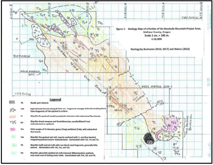
Figure 7.3-1 Stockade Mountain Geology Map
Sometime after the entire dome hardened and volcanic activity ceased, a series of NW trending faults occurred. These faults became mineralized as breccia veins: Filled with fragments of opalized and/or chalcedonized rock (largely Tr) in a matrix of opal, chalcedony, and at times, agate.
7.3.2 Details of General Geology
A fine-grained to very fine-grained porphyritic rhyolite stock (Tr) formed a dome elongated NW for 2.1 km. by at least 800 meters wide. Where not altered, the Tr is grey to brownish grey in color. Outcrops display conspicuous flow bandings, but outcrops are few. Many areas mapped as Tr are based on abundant pieces of planar, platy, flow-banded float.
To the southeast of Opal Hill, the Tr intrusive contact into host rhyolitic tuff units is well exposed as a 10 to 130 meters wide subvertical dike-like band of black (where unaltered - Trvb) to green (where opalized - Trvg) vitrophyre (Trv) that marks the chilled margin of the intrusive dome where the SE lobe of the dome intruded into its own frontal breccia (Trf - exposed as the Nelson Breccia). This glassy material, whether black or green, displays well-defined, steeply dipping to vertical flow bands and forms at the nearly vertical boundary between the Tr (to the NW) and the Nelson Breccia to the SE (see Figure 7.3-1).
| NI 43-101 Technical Report Stockade Mountain Project | Page: 75 | |
| Malheur County, Oregon, USA | ||
Frontal and carapace breccias (Trf) are also observed on the NW end of the dome. There, the lithic fragments are illitized (Trfi) and form low, apparently easily eroded and inconspicuous outcrops. Other outcrops in the immediate area of the illitized Trf indicate illitized to fresh Tat, Tts and Tlt are interbedded in the Trfi, shown schematically on the cross-section A-A' and longitudinal section B-B' - B"- B'''. All lithologic units in the Craters Area strike northwesterly and dip 10-30°W. Bedding in Trf is observable, but rarely, as alignments of fragments.
Where the NW-trending chalcedony/opal veins cut the Trf in the Craters area, the Trf is strongly cemented with variable mixtures of chalcedony, opal and agate, herein labeled Trfs. These areas of Trfs rubble form resistant outcrops, and many dozens of smaller outcrops of silicified Trf are noted where NW veins cut them. These silicified Trfs and Trfi outcrops are bedded, parallel to the interbedded Tat, Tts and Tlt, but are only silicified where cut by the later NW trending veins. Photo 2 shows the strongly silicified Trf breccia near the NW veins and should be contrasted with Photo 1, showing the illitized nature of the Trf away from the effects of NW veins.
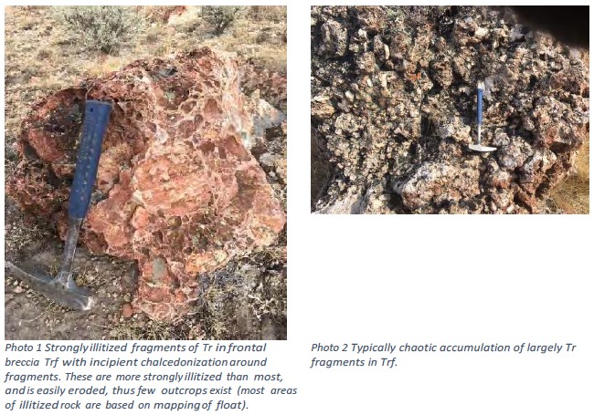
7.3.3 Structure
Stockade Mountain structure is dominated by northwest-trending faults that were the conduits for the hot springs fluids. These faults are commonly mapped as silicified/breccia zones that outcrop sporadically within the altered and mineralized area and typically display a high-angle dip to the northeast. However, the CSAMT data and interpretation suggest some may dip to the southwest, thus forming graben features. Post-mineral faults that also trend northwesterly are interpreted to occur along the east side of the exposed altered and mineralized rocks and are interpreted to down-drop the mineralized tuffs and domes under post-mineral basin sediments.
| NI 43-101 Technical Report Stockade Mountain Project | Page: 76 | |
| Malheur County, Oregon, USA | ||
7.3.4 Alteration and Mineralization
The gold/silver veins being targeted at Stockade Mountain would have formed within the vertical zone of vigorous boiling of the hydrothermal fluids, and this is interpreted to have occurred approximately 600 to 1,200 feet (183 to 366 meters) below the surface.
Probably contemporaneous with the intrusion or very soon thereafter, numerous northwest zones of fracturing occurred, cutting the Tr dome and also cutting the domal breccia accumulations (Trf) and the interbedded extrusive rhyolite tuffs (Tat, Tts, etc.). These fractures typically strike N45°-60°W with a predominant dip of 60°-80°E, but a minority of the structures has a vertical to 70°W dip. The fractures average 1.5 meters wide, with many from 10 cm to 3.0 meters wide (and a few up to 10 meters) and are steeply dipping planar bodies filled with well-cemented rock fragments, forming breccia veins (See Photo 3 and Photo 4).
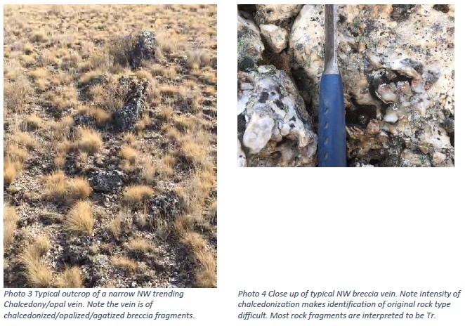
All breccias in the veins (Teb) are cemented with a variable mixture of chalcedony, opal and agate. These breccia veins cut all units, but where they cut the frontal or carapace breccia horizons, the silicification spreads out laterally along the permeable bedding for up to 25 meters away from the NW-trending chalcedony/opal veins, as shown in Photo 5. Thus, the larger bodies of Trf shown in the NW end of Figure 7.3-1 are those breccia beds that received the larger amounts of hydrothermal solutions depositing chalcedony/opal from the NW veins and those solutions moved out laterally along bedding into the Trf. As stated, there are dozens, if not hundreds, of other outcrops of similarly silicified Trf not shown on Figure 7.3-1, but these are much smaller in extent, though the intensity of alteration seems to be the same. Also, there are hundreds of subcrops of Trfi, the illitized frontal breccias, but these do not crop out well due to their softness (see Photo 1 and 5).
| NI 43-101 Technical Report Stockade Mountain Project | Page: 77 | |
| Malheur County, Oregon, USA | ||
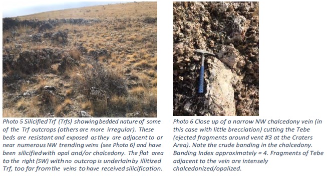
The opal is commonly red, brown, yellow and light grey and less commonly black. The chalcedony is typically white, light grey, or more rarely dark grey to black in color. A typical breccia vein would have white to light grey angular to subrounded fragments of intensely opalized rock, cemented with a matrix of irregular patches and veinlets of white, brown, red, or black opal and chalcedony, and more rarely, colorful agate. Iron oxides (limonite, hematite, plus Mn oxides) are not common but are found in a few veins as stains and thick crusts on opal/chalcedony veins and veinlets. Samples of these iron-oxide-rich veins showed no anomalous values, except in Hg. Very late stage drusy quartz in crystals 0.1 mm in size, is common in the silicified Trf. No barite, fluorite, adularia, or sulfides typical of epithermal veins were noted on any outcrop.
As almost all veins seen were breccia veins; the few that are not brecciated stand out for attention: Only six vein outcrops out of the several hundred observed show any banding at all, presumably along those few stretches of veins that somehow avoided brecciation. Some non-breccia veins have very crude banding of white and grey chalcedony and chalcedony+opal, and rarely with bands of limonite mixed with hematite. Those with banding have a banding index (#bands/10cm of width) that varies from 1 to 12, a low number generally as it means the bands are from 8 to 100 mm in thickness, considered "coarse" compared to many productive epithermal districts. But the presence of any banding at all is encouraging as each band represents a change in the physical and/or chemical nature of the fluids at depth.
It appears the non-brecciated parts of the chalcedony veins change to breccia veins on strike (and likely on dip) within a few tens of meters of strike, where no banding is observed.
These breccia veins, banded or not, crop out well at and near the margins of the Tr dome but are nearly absent in the center of the dome. The central part of the dome is illitized with the rock softened, thus outcrops are rare and discontinuous, and vein outcrops are even rarer. The author believes that wide veins in the central portions of the dome would have cropped out, thus the assumption is that veining in the center of the dome was weaker, with thinner and less continuous veins, perhaps due to less access to voluminous amounts of water available for boiling. That water would be present in the permeable frontal breccias and in the bedded volcanics on the margins of the domes, and thus boiling was pronounced.
| NI 43-101 Technical Report Stockade Mountain Project | Page: 78 | |
| Malheur County, Oregon, USA | ||
7.3.5 Target Areas
The following text is a description by Buchannan & Buchanan (October 2017) of some of the more noteworthy, mineralized zones on the Stockade Mountain Property. Figure 7.3-2 shows the locations of these occurrences relative to the mineral land holdings.
| NI 43-101 Technical Report Stockade Mountain Project | Page: 79 | |
| Malheur County, Oregon, USA | ||
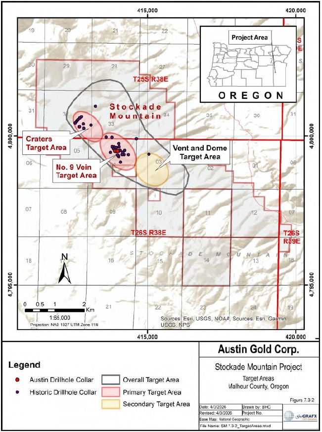
Figure 7.3-2 Mineralized Zones at Stockade Mountain
| NI 43-101 Technical Report Stockade Mountain Project | Page: 80 | |
| Malheur County, Oregon, USA | ||
Detailed discussions by Buchanan and Buchanan (Buchanan & Buchanan, October 2017) of the most mineralized zones in the project area follow.
7.3.5.1 Opal Hill / Number 9 Vein Target Area
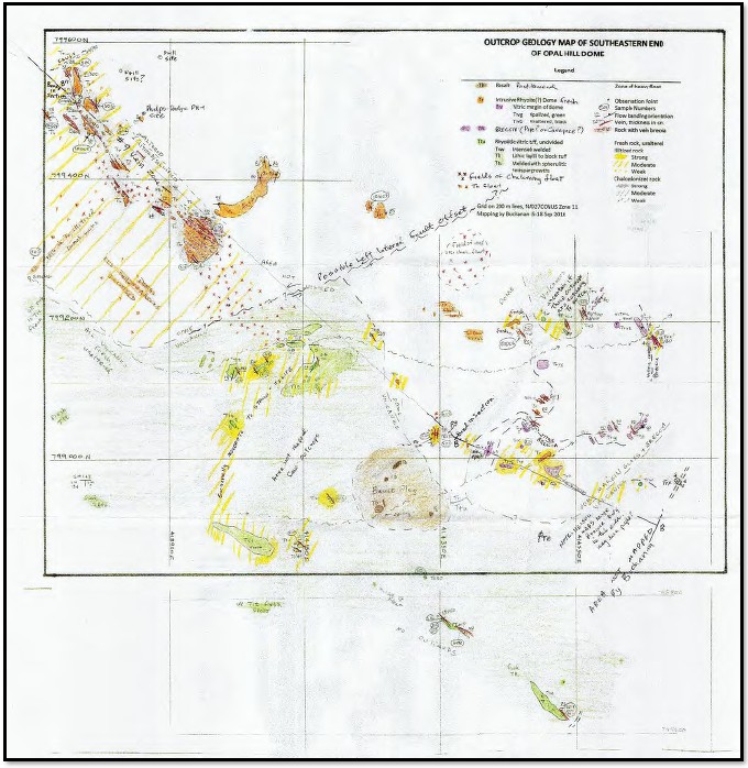
Figure 7.3-3 Opal Hill Dome Geology Map
The Number 9 Vein zone atop Opal Hill (shown in Figure 7.3-3) drilled by Phelps Dodge and Placer Dome can be traced discontinuously to the NW for at least 1,200 meters. At Opal Hill, the Number 9 Vein zone is hosted in illitized Tr and is made up of at least five parallel breccia vein structures within a width of 75 meters, with individual veins up to 5 meters wide but typically 0.5-2.0 meters wide. Moving to the NW from Opal Hill into the center of the dome, the number of veins decrease for the first 400 meters as stated above, but then farther NW they increase again until in the area of the Craters at the Tr/tuff+Trf contact there are many dozens of breccia veins. It is believed this increase in the number of veins near the Tr contact is merely due to proximity to that contact: that is, it is very possible the increase in the fracturing and subsequent brecciation and then vein forming is merely where the tuffs and Trf contained high amounts of interstitial water (relative to the Tr) and therefore the boiling at depth in the structures was more intense and concentrated at and near the Tr/tuff+Trf contacts. As rhyolites contain under 4% water and as opal is a hydrated polymorph of SiO2 with 5 to 22% contained water, all opalization at Stockade likely resulted from heated ground water held in the tuffs and Trf, plus some input from heated hydrothermal waters rising up the NW set of fractures.
| NI 43-101 Technical Report Stockade Mountain Project | Page: 81 | |
| Malheur County, Oregon, USA | ||
The presence of stratabound intense opalization in the Tts unit in the far northeast end of the mapped area (See Figure 7.3-1) suggests the water content in that tuff unit at the time of intrusion resulted in widespread boiling with consequent opalization. The concept of a boiling water table may be applicable as the entire Tts unit appears strongly and relatively evenly, almost monotonously, opalized throughout its outcrop exposure. The numerous veins in the Tr, Trf and Tat adjacent to and above the opalized Tts unit are merely fracture zones above that boiling horizon where steam and hot waters escaped from depth. This extremely violent boiling event localized near the Tr-Trf contacts may explain the absence of veining in the center of the dome as the waters held in the tuff beds and permeable Trf breccias would not have migrated very far into the dome before being vaporized away.
The following is derived from the Placer Dome report by Majstrick and Dodd (1993).
The most extensive and highest-grade gold mineralization exposed on the Property occurs in the rhyolite dome in the North ½ of Section 4 and accordingly, it has received the greatest exploration interest (Figure 7.3-3). Phelps Dodge drilled 12 holes mainly in the south and central parts of the dome and Placer Dome drilled 5 holes to evaluate mineralization in the north part of the dome. As defined by the drilling, the dome is elliptical in plan view 1,600 feet NW-SE x 1,000 feet NE-SW with a steep-sided funnel shape in cross-section. It is in contact with underlying tuff breccia on the north and east sides and bound on the west by the N50W fissure and a near vertical contact with opalite and chalcedony-silicified upper rhyolite. The dome continues to a TD depth of 440 feet in Phelps Dodge hole STKDH-16 just east of the N50W fissure. Structural relationships on the southside have not been determined.
Placer Dome drill sites average 300' apart. Phelps Dodge sites range from 100 feet to 400 feet apart with some clustering as a result of follow-up drilling. All drill intervals, grades, and distances are reported in the original units as presented in historical operator records. Best intercepts by Placer Dome include hole STK93-6, 340' @ 0.014 opt Au from 225' - 565' TD with 55' @ 0.030 opt Au from 225' - 280', and STK93-5, 55' @ 0.025 opt Au from 135' - 190'. Best intercepts by Phelps Dodge include hole STKDH-9, 430' @ 0.018 opt Au from 30' - 460' with 125' @ 0.037 opt Au from 150' - 275', hole STKDH-18, 240' @ 0.017 opt Au from 165' - 405', and several intervals of 80' @ 0.010 opt Au. Anomalous intervals were bracketed by unmineralized rock in all holes except STK93-6. The better intercepts are separated from each other by zones with weak mineralization only. A pattern has not been recognized which can link mineralized domains or project mineralization into adjacent areas. Generally, higher grade mineralization tends to occur at the margins of the dome and nearer to the feeder conduit suggesting structural contacts exerted an influence on fluid channeling. Mineralization continues to the total depth drilled, approximately 440 feet vertically from the top surface of the dome.
Placer Dome drilled three holes immediately north of the dome to test continuity of mineralization in this direction. Holes STK93-3 and STK93-9 failed to intersect mineralization which indicates the "west zone" and "east zone" concept trends developed by Phelps Dodge have validity for the dome only. A reinterpretation suggests these are a result of contact-controlled mineralization along the edges of the dome. Hole STK93-4 intercepted quartz vein stockwork mineralization in tuff breccia from 205' - 290' TD. Veins and style of mineralization are similar to occurrences in the dome except gold grades are lower ranging from 0.005 to 0.0131 opt with the best intercept being 15' @ 0.012 opt Au from 295' - 310'. The tuff breccia appears to be a less favorable host because of its plastic, clay-rich, non-permeable character.
| NI 43-101 Technical Report Stockade Mountain Project | Page: 82 | |
| Malheur County, Oregon, USA | ||
Phelps Dodge drilled 5 holes which tested areas immediately outside the dome. Hole STKDH- 17 encountered barren opalized and chalcedony-silicified upper unit rhyolite at a site collared 300 feet southwest of the N50W fissure and 300 feet west of the highest-grade intercept on the Property in hole STKDH-9. Holes STKDH-10, 19, and 20 were drilled east of the dome and angled back toward the dome. Dome mineralization was not intersected because of post-mineral faulting along the dome flanks with east side-down movement and the funnel-form inward dipping dome basal contact. Hole STKDH-2 was drilled south of the dome in upper unit rhyolite with stockwork quartz veins but did not intersect anomalous mineralization. Phelps Dodge also drilled two holes in opalite-chalcedony mineralization approximately 1,200 feet NW of the dome. Both holes failed to intersect anomalous mineralization.
7.3.5.2 The Vents at Craters (The Swamp) Target Area
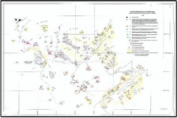
Figure 7.3-4 Outcrop Geology of the Craters Area
In both the NW and SE areas near the Tr contacts shown in Figure 7.3-4, are six wide areas of brecciation, with five in the Craters area. The Craters area is often referred to as 'The Swamp' in previous reporting. One, the most westerly of the five herein called the Vent Area, differs from the others. There, unlike the other large and many smaller outcrops of silicified Trf, the Trf fragments are not in place. This outcrop area consists of 7 small hydrothermal vents where violent eruptions threw up rocks (largely Tr lithology) to form a slightly elevated rim around the seven vents, leaving the vents as shallow depressions surrounded with 1-3 meters high aprons of ejected debris (Tebe) that extend from 5 to 20 meters away from the vents. This debris, looking remarkably similar to the Trf in other outcrops (where they are bedded) is similarly chalcedonized and/or opalized, often with late druses of quartz, just like the bedded and silicified Trf in the other large areas of outcrop. However, it is clear from the topographic expression at the Vent Area that the fragments had been shot up and out of the vents.
| NI 43-101 Technical Report Stockade Mountain Project | Page: 83 | |
| Malheur County, Oregon, USA | ||
At the Vent Area the seven semi-circular depressions vary from 10 to 22 meters in diameter, are aligned in a NW direction, and are surrounded by what appears to be a flat-lying accumulation of breccia fragments around the margin of the depressions. The well-exposed breccias (Tebe) form generally flat- lying accumulations of ejected fragments of intensely chalcedonized and/or opalized fragments, in a weakly to strongly cemented matrix of opal and/or chalcedony. The fragments are chaotic; that is, they do not show any preferred orientation and appear to have been dumped out on the surface around the several erupting hydrothermal vents. The rocks within the vents themselves are not exposed as soil and debris have partially filled in the vent depressions.
Much of the tuff breccia and rhyolite in SE quarter of Section 32, SW quarter of Section 33, and the N half of Section 4 has been replaced by opalite and chalcedony. Silica decreases rapidly southwest of the N50W fissure and gradually decreases northeast of the fissure. Chalcedony ribs and later joints and fractures all trend N30-60W parallel to regional trends.
All surface rock chip samples of opalite, chalcedony and argillic tuff breccia contain less than 20 ppb gold. A soil survey grid by Phelps Dodge also did not identify anomalous gold in this system. Placer Dome rock and soil anomalies near samples STKPM93-60 and 200VMC in the SE quarter of Section 32 are due to a few irregular stockwork-type quartz veins.
A resistivity survey was conducted in the SE quarter of Section 32 and the SW quarter of Section 33 to identify the thicker silica caps which could overlie conduits for mineralization. The survey outlined an elliptical-shaped area of high resistivity with a N60W axis 800 feet NW-SE x 300 feet NE-SW associated with the N50W fissure. Resistivity contours northeast of this area are variable and an order of magnitude lower suggesting zones of discontinuous and rootless silicification interlayered with argillized volcanics. Two sites were chosen close to the fissure to evaluate potential mineralization beneath the silica cap.
Placer Dome hole STK93-1 intercepted 165 feet of tuff breccia and rhyolite with stockwork quartz veins similar to the mineralization in the domes. The veining occurred below a silica cap with a 215 feet vertical thickness and an interval of unmineralized tuff breccia with an 80 feet vertical thickness. Although veining is relatively strong, best intercepts include only 30' @ 0.015 opt Au from 345' - 375' and 40' @ 0.016 opt Au from 455' - 495'. Hole STK93-2 intersected a silica cap with a 270-foot vertical thickness followed by a rhyolite sequence with a 140-foot vertical thickness. Mineralization was not intersected possibly because of the increased distance of the hole from the fissure or its relatively shallower penetration depth as indicated by the absence of the dacite marker horizon (Mejstrick & Dodd, 1993).
Nine other holes have been drilled in the north target area. Phelps Dodge hole STKDH-13 was collared in variably silicified and argillized tuff breccia just east of a massive-appearing chalcedony outcrop 800 feet NE of the N50W fissure. The upper 175' consisted of opalized and argillized tuff breccia. The lower 125 feet consisted of a dacite flow probably correlative with the dacite in STK93-1. No anomalous intervals were intersected. Phelps Dodge hole STKDH- 22 was drilled approximately 300 feet SW of the fissure. The hole was targeted on gold anomalies in rocks and soils caused by a narrow zone of stockwork quartz veins and down-dip from a fault projected along a NW-oriented dry draw. The upper part of the hole consisted of argillized and weakly opalized tuff breccia. Basalt was intersected from 200' - 295' followed by pyritic dacite tuff to 345' TD. A 10' interval from 125' - 135' contained 0.028 opt Au.
| NI 43-101 Technical Report Stockade Mountain Project | Page: 84 | |
| Malheur County, Oregon, USA | ||
Carlin Gold drilled a tightly spaced fence of 6 angle holes across the trend of the N50W fissure. Holes intersected tuff breccia and several thick intervals of fault or hydrothermal clay. Adjacent holes SCM-4 and SCM-7 intersected low grade mineralization of 45' @ 0.007 opt Au from 265' - 310', and 140' @ 0.007 opt Au from 220' - 360' respectively. The anomalies are not associated with stockwork veins. Holes to the northeast and southwest of SCM-4 and SCM-7 are unmineralized or contain narrower and lower grade intercepts. The anomalies in holes SCM-4 and SCM-7 are on a N50W trend with the stockwork veins in STK93-1 and within the same general depth interval.
Carlin Gold hole SCM-1 was collared in rhyodacite on a NW-trend with the opalite and chalcedony mineralization. The hole intersected 200 feet of unaltered rhyodacite above 200 feet of silicified and argillized tuff breccia. There were no anomalous gold intercepts.
7.3.5.3 Vents and Dome Target Area
Considered to be a "secondary" target area, Vents and Dome comprises an area of opalization and silicification of a rhyolite dome and carapace breccia along with an area that is believed to be a hot springs vent area (or the immediate subsurface of a vent area). The airborne radiometrics survey conducted in 2021 shows this area to be anomalous in potassium - possibly indicating k-feldspar or adularia within the alteration assemblage.
| NI 43-101 Technical Report Stockade Mountain Project | Page: 85 | |
| Malheur County, Oregon, USA | ||
8 DEPOSIT TYPES
In Southeastern Oregon, widespread Neogene felsic volcanic rocks, along with considerable Neogene normal faulting, provide a compositionally and structurally appropriate environment for low-sulfidation Au-Ag deposits (previously known as hot-spring Au-Ag deposits1) formed in a paleo hot springs environment (Berger, 1986). Based on the geological setting, hydrothermal alteration, styles of gold- silver mineralization, and close spatial and timing association with silica sinter deposition, the Stockade Mountain Project is best interpreted as a volcanic-hosted, high-level, low-sulfidation epithermal mineral system.
Epithermal gold-silver deposits form in the uppermost parts of the crust, at less than 1,500 meters (m) below the water table and contain gold and/or silver minerals in structurally controlled veins and breccias and disseminated in larger host rock volumes (John, et al., 2018). Within the group of epithermal deposits, (as summarized by Simmons and others (2005)), all modern classification systems consider ore or gangue mineralogy features, and many use chemical characteristics (pH, oxidation state, or sulfidation state) of fluids associated with proximal hydrothermal alteration and/or ore mineralization (John, et al., 2018).
Low sulfidation deposits formed at low sulfur fugacities resulting in alteration and vein mineral assemblages that are consistent with near-neutral pH conditions. They commonly exhibit vertical zoning for precious metals that correspond to the levels of boiling that occurred within the hydrothermal system. Episodic sealing and explosive activity formed the breccias and stockworks commonly observed in the structures, and the concurrent rapid pressure changes resulted in the precipitation of carbonates and, in many cases, the subsequent resorption and replacement of the carbonates by quartz that result in a lattice-texture and bladed texture where quartz replaces calcite (Simmons & Christenson, 1994). Bladed quartz replacing calcite frequently is observed in low-sulfidation, epithermal gold deposits. Bladed calcite have also been documented in boiling zones of some active epithermal systems and boiling in these systems has been directly linked to gold mineralization. These textures are noted as an important feature because they record the rapid changes associated with the boiling zone and are associated with the precipitation of gold (Etoh, Izawa, Watanabe, Taguchi, & Sekine, 2002).
Gold ore in low-sulfidation deposits is commonly associated with quartz and adularia with possible calcite or sericite as the major gangue minerals. The form of the deposit can vary from vein (Sleeper, Midas, El Pinon, and Hishikari) to stockwork (McLaughlin, Castle Mountain, Cerro Crucitas) to disseminated (Round Mountain). Associated mineral deposits may include hot-spring mercury deposits and antimony deposits. The alteration halos to the zone of mineralization, particularly in vein-controlled mineralization, include a variety of temperature-sensitive clay minerals. The areal extent of such clay alteration may be two orders of magnitude larger than the actual ore deposit. This is usually the case with shallow, lower-temperature alteration, that mushrooms near the surface owing to the intersection of an aquifer by basement feeder structures, the latter potentially being host to high-grade ore. Typically, the near surface stockworks and breccia deposits are much larger in tonnage and lower in grade than the underlying vein deposit.
___________________________
1 Model classifications described here for the subtypes of epithermal deposits replace previous U.S. Geological Survey models for epithermal gold-silver deposits (Cox and Singer, 1986). Previous U.S. Geological Survey models consisted of Comstock epithermal veins, Creede epithermal veins, and Sado epithermal veins, which are combined into the low- and intermediate-sulfidation subtypes; hot spring gold-silver, which is divided between low- and high-sulfidation subtypes; and quartz-alunite gold, which is part of the high-sulfidation subtype (John, et al., 2018).
| NI 43-101 Technical Report Stockade Mountain Project | Page: 86 | |
| Malheur County, Oregon, USA | ||
Wall-rock alteration assemblages associated with low sulfidation epithermal systems commonly exhibit silicification proximal to the veins and stockworks, illite, chlorite, albite, epidote, zeolites, and pyrite, in addition to quartz, adularia, and calcite. These minerals reflect the near neutral-pH and reduced composition of the ore fluid. Interstratified illite-smectite and smectite clays plus kaolinite occur on the margins of the system, as well as within the ore zone, in some cases as supergene alteration products of hydrothermal sericite (Hedenquist, Arribas, & Gonzalez-Urien, 2000).
A conceptual, schematic section (Figure 8-1) shows a low-sulfidation epithermal system and its variable form with increasing depth, and the typical alteration zonation, including the distribution of sinter, a blanket of steam-heated advanced argillic alteration, and water-table silicification (Buchanan L. , 1981)
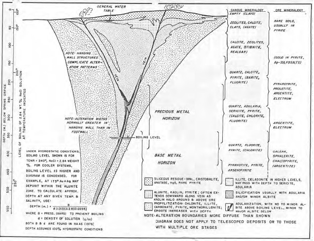
Figure 8-1 Conceptual Low Sulfidation Epithermal Deposit Model
Most low-sulfidation deposits mined underground and from open pits vary in size from 100,000 ounces to 10,000,000 ounces of gold produced (2.84 to 284 metric tons (tonnes)), however some have yielded greater than 10,000,000 ounces. Ore grades typically range from several to more than 10 grams per metric ton gold (≥0.3 opt) and from tens to hundreds of grams per metric ton silver (several to several tens of ounces per ton) (Albinson, 2001). The relatively high grades of these veins, and their selective minability, have historically enabled production from small deposits.
| NI 43-101 Technical Report Stockade Mountain Project | Page: 87 | |
| Malheur County, Oregon, USA | ||
Table 8.1 shows estimated pre-mining tonnages and grades for low-sulfidation Au-Ag deposits in the United States described by John (2018)
Table 8-1 Grades and tonnages of low-sulfidation Au-Ag deposits in the US
| Deposit | State | Au grade (g/t) | Ag grade (g/t) | Ore (metric tons) |
| Aurora | NV | 16.4 | 184 | 3,481,000 |
| Bodie | CA | 32.4 | 161 | 1,400,000 |
| Bullfrog | NV | 2.52 | 3.3 | 25,710,000 |
| Haile | SC | 1.82 | 2.61 | 74,628,050 |
| Hycroft (Crofoot-Lewis, Sulphur) | NV | 0.26 | 10.7 | 2,268,629,465 |
| McLaughlin | CA | 3.42 | ~1.6 | 33,900,000 |
| Midas | NV | 15.1 | 200.9 | 6,359,000 |
| Mule Canyon | NV | 3.1 | 3 | 14,441,000 |
| National District | NV | 67.9 | 181.5 | 81,000 |
| Oatman | AZ | 16.5 | 9.7 | 3,695,000 |
| Republic | WA | 19.3 | 108 | 4,779,000 |
| Round Mountain | NV | 0.53 | 806,455,238 | |
| Sleeper | NV | 0.46 | 3.01 | 344,702,000 |
Many other deposits of this class occur within the Basin and Range province of Nevada, and elsewhere in the world. Some well-known low-sulfidation epithermal gold and silver properties with geological similarities to the Stockade Mountain Project include the past-producing Rawhide, Sleeper, Midas, and Hog Ranch mines in Nevada, and Delamar in Idaho.
| NI 43-101 Technical Report Stockade Mountain Project | Page: 88 | |
| Malheur County, Oregon, USA | ||
9 EXPLORATION
At least six companies have conducted exploration on the Stockade Mountain Property since its discovery in the 1990s. A large amount of information has been generated; however not all that data has been recovered. Exploration programs by prior operators are discussed in Section 6: History. Exploration drilling completed by those prior operators and Austin Gold is described in Section 10: Drilling.
Austin Gold acquired the Property in May 2022 and then undertook significant data compilation of historical data and field reviews of those data and interpretations. Part of this effort was the review and interpretation by a consulting geophysicist of the historical gradient-array induced polarization- resistivity (IP/R) survey and aeromagnetic-radiometric survey conducted in 2020. Subsequent to the drilling of three diamond (core) exploration drill holes in 2023 and 2024, the Company hired a different consulting geophysicist to review and model the IP/R and aeromagnetic-radiometric surveys. The conclusion of this geophysicist was that the gradient array survey was not suitable for imaging potential vein-hosting structures at depths of 200-300 meters, which are the target depths for this project. The interpretation is near-surface responses masked responses within the targeted depth range. Accordingly, in the fourth quarter of 2025, the Company designed and completed a detailed geophysical Controlled Source Audio-frequency Magnetotellurics (CSAMT) survey to acquire better imaging of target structures. Data from the CSAMT survey has been plotted and interpreted by the Company's consulting geophysicist and management team.
A reverse circulation drilling program originally planned for 2025 has been deferred to allow incorporation of the CSAMT results into drill targeting. The Company's drilling program will be designed to test beneath known high-level gold/silver-bearing stockwork mineralization for high-grade vein deposits formed deeper in the hydrothermal system. All permits are in place to conduct the program, which will be subject to suitable drill availability and weather.
9.1 Geophysics
A CSAMT survey was conducted on the Project during November through December 2025 by Zonge International. Data were acquired along 17 lines, each 2.4 km long and spaced 200 m apart, providing a total of 40.8 line-km of coverage. Lines were oriented N40E which is perpendicular to the general orientation of the hydrothermal system and large-scale structural controls.
CSAMT is an earth-resistivity mapping method that uses signal from a remote (5-10 km) transmitter to measure the resistivity of the subsurface. Apparent resistivity is derived from measurement of electric field and orthogonal magnetic field at multiple frequencies. Depth of penetration of the signal is inversely proportional to the transmitted frequency and proportional to the resistivity of the subsurface. The measurements are processed using 2D Inversion software to produce a section of the resistivity variations at depth. The transmitted frequencies ranged from 1 to 8,192 hertz. The effective low frequency (transition zone) is 16 Hz. The maximum depth of investigation varied from approximately 300 to 400 meters.
Rock resistivity is fundamentally a function of porosity and pore water resistivity as well as clay content. For this project, the highest resistivities are observed for the areas of silicified breccias and massive, variably silicified rhyolitic domes (Tr). There is also high resistivity observed for apparent volcanic units that may have been permeable hosts for hydrothermal fluids and silicification (Tts?). Low resistivity of less than 5 to 10 ohm-m is observed for post-intrusion volcaniclastic sediments and lacustrine deposits that overlie the rhyolitic rocks beneath the northeastern ends of the survey lines. Similarly, the tuff beds underlying Stockade Mountain to the southwest exhibit very low resistivity, suggesting they are likely volcaniclastic or lacustrine deposits, or that they have undergone significant clay alteration. Strong clay alteration alone can also produce such low resistivities.
| NI 43-101 Technical Report Stockade Mountain Project | Page: 89 | |
| Malheur County, Oregon, USA | ||
High resistivity is observed for the Opal Hill area where a rhyolite dome (Tr) is exposed. The high resistivity is about 150 meters thick at its maximum with the highest resistivity values reaching 400 ohm- m (see Figure 9.1-1 Line 1800 Interpretative Section). The base of the high resistivity is relatively flat lying with variation in topography accounting for the variation in thickness. In the deepest drill holes (SM-23-02 and SM-24-04) the Tr extends well below the highest resistivity into resistivities of 25 to 55 ohm-m. Greenish clay/chlorite "propylitic" alteration was observed from 894 feet to the bottom of hole SM-23-02. A thick section of moderately-high resistivity extends to depth beneath the northeast half of the high resistivity dome. This Is suspected to be the dome vent area. A possible deep fault or contact and a potential fluid pathway lies along the west side of this feature. Some of the highest Au values encountered within the Project lie within the resistive Tr above this feature within an area of widely- spaced drilling. This structure is interpreted to continue at depth for approximately 600 meters along the northeast side of Opal Hill.
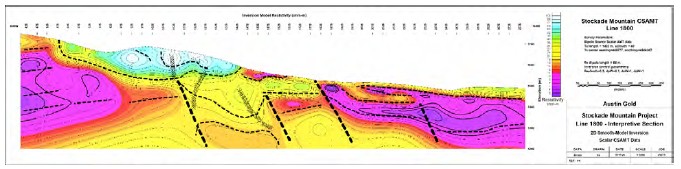
Figure 9.1-1 Line 1800 Interpretative Section
A large resistive mass is seen from the northwest side of Opal Hill to the Craters area (see Figure 9.1-2). This feature is thought to be a larger rhyolitic intrusive body that comes to within about 100 meters of the surface. The feature is associated with a magnetic low. The feature lies beneath a pronounced area of concave-northeast curvature forming the northern terminus of the Stockade Mountain ridgeline. The westerly-dipping tuff units appear to have steeper dips in this area than they do to the south.
The Craters Area lies within a northwest-trending zone of high resistivity that coincides with the vents. The vents have generally higher resistivity at surface and near-vertical, moderately high-resistivity resistive feeders extending beneath them. Low grade mineralization has been encountered in the axis of the vent on Line 3200 at a depth of approximately 120 meters. On Line 3400, a Broad, high-angle zone of moderately- high resistivity lies beneath the near-surface vent breccias. The highest Au values in the drill fence are intersected near the bottom of drill-hole SCM-7 which is the deepest hole near the axis of the high-resistivity zone.
A zone of high resistivity is observed beneath shallow volcanic cover in the southeast corner portion of the grid suggesting that Tr extends to the northeast beneath the Tertiary Sediments.
| NI 43-101 Technical Report Stockade Mountain Project | Page: 90 | |
| Malheur County, Oregon, USA | ||
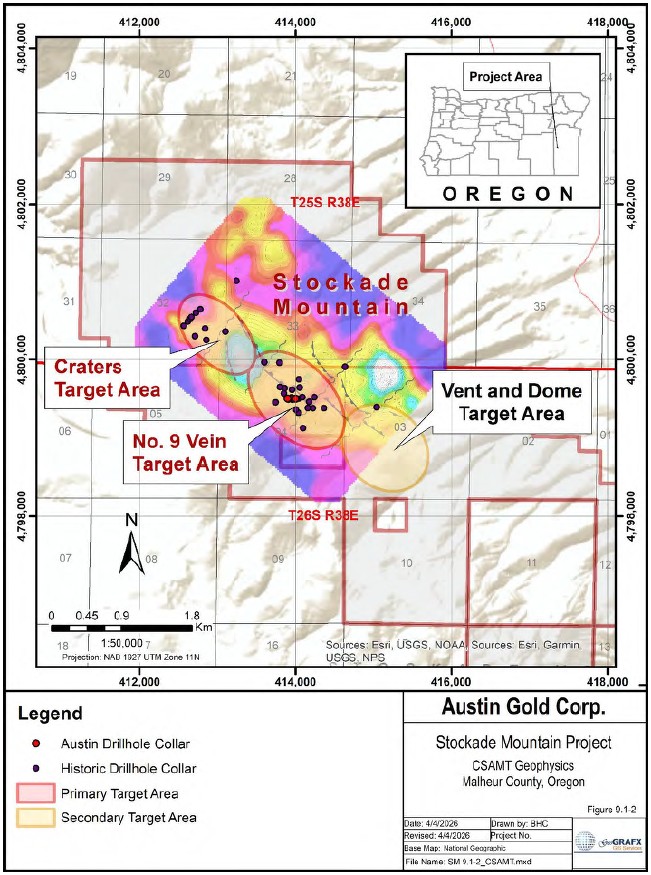
Figure 9.1-2 CSAMT Geophysics
| NI 43-101 Technical Report Stockade Mountain Project | Page: 91 | |
| Malheur County, Oregon, USA | ||
10 DRILLING
Available records show 40 holes were drilled on Austin Gold's Stockade Mountain Property between 1989 and 1993 to explore for gold and silver mineralization that could be mined by open pit methods. A drill-hole summary is shown in Table 10-1 and a list of all known existing drill holes is included in Appendix C
During the winter of 2023-24, Austin Gold drilled 3 diamond drill holes totaling 2,435.9 feet (742.5 meters) in the Opal Hill/Number 9 Vein target area.
Table 10-1 Summary of Holes Drilled at Stockade Mountain Project
| Company | Date | Number Holes |
Feet | Type | ||
| BHP - Utah International | 1990 | 1 | 400 | Reverse Circ | ||
| Phelps Dodge | 1990 | 13 | 5,385 | Reverse Circ | ||
| 1991 | 9 | 4,170 | Reverse Circ | |||
| Carlin Gold | 1992 | 7 | 2,870 | Reverse Circ | ||
| Placer Dome | 1993 | 10 | 4,330 | Reverse Circ | ||
| Austin Gold | 2023- | 3 | 2,436 | Core | ||
| 2024 | ||||||
| TOTAL | 43 | 19,591 | ||||
The location of all exploration holes drilled to date on the Project is shown in Figure 10-1. Additional information on the historical drill holes can be found in Section 6.8.
| NI 43-101 Technical Report Stockade Mountain Project | Page: 92 | |
| Malheur County, Oregon, USA | ||
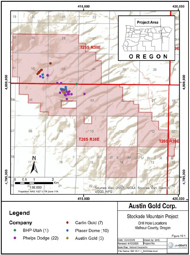
Figure 10-1 Drill Hole Location Map
| NI 43-101 Technical Report Stockade Mountain Project | Page: 93 | |
| Malheur County, Oregon, USA | ||
10.1 2023-24 Austin Gold
On October 16, 2023, the Company initiated a diamond drilling program at the Stockade Mountain Project designed to test beneath the known high-level gold/silver-bearing stockworks mineralization for high-grade vein deposits formed deeper in the hydrothermal system. This is the first known use of diamond drilling on the Property, which allowed the Company to have a better understanding of the host rocks and mineralization.
The 2023 drilling program began testing what has been historically known as the "Number 9 Vein" or "Opal Hill" area in the central part of the Company's land package. Gold values from surface outcrops of the vein are weak, with a high value of 0.013 g/t. However, the historical drilling indicates that significant thicknesses of stockwork mineralization begin just below the surface and extend at least 1,250 feet (380 meters) eastward from the exposed vein zone and 2,300 feet (700 meters) along strike. The hypothesized high-grade gold/silver veins at Stockade Mountain would have formed within a vertical zone of vigorous boiling of the hydrothermal fluids near the base of and below the stockworks.
Austin Gold's drilling program consisted of three diamond drillholes totaling 2,435.9 feet (742.5 meters). The Company announced the gold assay results from the first two drillholes at its Stockade Mountain Project on January 30, 2024. These holes confirm that the mineralizing system at Stockade Mountain is robust and contains significant gold grades, with the strongest intercept of 8.19 g/t over 4 feet (1.2 meters) and several other gold intercepts of interest.
Results from the third and last drill hole of the program, SM-24-04, were announced on March 25, 2024, and include a gold intercept of 9.32 g/t over 2.7 feet (0.82 meters). These results continue to demonstrate the strength of the hydrothermal system and the potential for significant gold mineralization within the project area.
Extremely wet and muddy conditions due to significant rain, snow and an unusually warm winter caused substantial difficulties and delays while drilling the third hole. The Company shut down the drill program due to permitting restrictions and excessive disturbance caused by the drilling activity. The following table is of the most significant gold intercepts in these three holes:
| Hole ID | From | To | Interval | From | To | Interval | Gold |
| (ft) | (ft) | (ft) | (m) | (m) | (m) | g/t | |
| SM-23-01 | |||||||
| 155 | 293 | 137.9 | 47.2 | 89.3 | 42.1 | 0.636 | |
| Incl. | 161.4 | 166.4 | 5 | 49.2 | 50.7 | 1.5 | 1.713 |
| Incl. | 279 | 283 | 4 | 85.0 | 86.3 | 1.2 | 8.19 |
| 308.8 | 337.2 | 28.4 | 94.1 | 102.8 | 8.7 | 0.326 | |
| Incl. | 308.8 | 312.1 | 3.3 | 94.1 | 95.1 | 1.0 | 2.809 |
| 382.5 | 386.2 | 3.7 | 116.6 | 117.7 | 1.1 | 2.472 | |
| SM-23-02 | |||||||
| 47 | 63 | 16 | 14.3 | 19.2 | 4.9 | 0.368 |
| NI 43-101 Technical Report Stockade Mountain Project | Page: 94 | |
| Malheur County, Oregon, USA | ||
| Hole ID | From | To | Interval | From | To | Interval | Gold |
| (ft) | (ft) | (ft) | (m) | (m) | (m) | g/t | |
| Incl. | 60.3 | 63 | 2.7 | 18.4 | 19.2 | 0.8 | 0.762 |
| 254 | 273.7 | 19.7 | 79.3 | 83.4 | 4.1 | 0.417 | |
| Incl. | 254 | 260.3 | 6.3 | 77.4 | 79.3 | 1.9 | 0.752 |
| 296.8 | 304.5 | 7.7 | 90.5 | 92.8 | 2.3 | 0.513 | |
| 698.5 | 706.6 | 8.1 | 212.9 | 215.4 | 2.5 | 0.752 | |
| Incl. | 698.5 | 701.4 | 2.9 | 212.9 | 213.8 | 0.9 | 1.276 |
| 769 | 771.5 | 2.5 | 234.4 | 235.2 | 0.8 | 1.718 | |
| SM-24-04 | |||||||
| 242 | 245 | 3 | 73.8 | 74.7 | 0.9 | 0.515 | |
| 607 | 609.7 | 2.7 | 185.0 | 185.8 | 0.8 | 9.32 | |
| 609.7 | 612 | 2.3 | 185.8 | 186.5 | 0.7 | 1.04 | |
| 654 | 656 | 2 | 199.3 | 200.0 | 0.6 | 0.363 | |
| 674.8 | 678 | 3.2 | 205.7 | 206.7 | 1.0 | 0.378 | |
| 712.4 | 713.9 | 1.5 | 217.1 | 217.6 | 0.5 | 1.22 |
10.2 Methodology and Logging Procedures
10.2.1 Hole Planning, Site Preparation and Set-Up
Drill sites and access roads were designed in Datamine Discover software and then laid out and flagged by Austin Gold's Vice President, Exploration. Road and drill site construction was accomplished with a Cat D-6 equivalent bulldozer by a contracting company based out of Meridian, Idaho.
A handheld GPS was used to locate all drill pads for the planned holes, and each site was constructed to the minimum size necessary to safely accommodate the drill rig, auxiliary equipment, and vehicles. Pads were prepared to a sufficient size, as terrain allowed, to enable drilling of multiple holes with varying azimuths from a single setup. To align the rig, front and back sights were established using stakes positioned just off the pad, and the drill rig was oriented parallel to these reference points. The supervising geologist approved the rig azimuth and verified the alignment after the mast was raised by the driller; final adjustments were made as required.
| NI 43-101 Technical Report Stockade Mountain Project | Page: 95 | |
| Malheur County, Oregon, USA | ||
As of this time, drill hole collars have not been re-surveyed with a survey grade GPS.
10.2.2 Drill Collar Coordinates
Upon completion of drilling, the locations were re-surveyed by the geologist using a Garmin 65 GPS and marked on the ground with a wooden stake showing the hole ID. Coordinates are UTM NAD27 Z11.
| Hole_ID | Easting_NAD27 | Northing_NAD27 | Elev_m | Depth_m | Depth_ft | Azimuth | Dip |
| SM-23-01 | 413900.3 | 4799500 | 1667.2 | 212.4 | 697 | 270 | -50 |
| SM-23-02 | 414000.3 | 4799495 | 1669.3 | 305.57 | 1002.2 | 270 | -55 |
| SM-24-04 | 414001 | 4799497 | 1669.3 | 224.55 | 736.7 | 0 | -72.5 |
10.2.3 Drilling Program
Austin Gold's core drilling contractor was Scout Drilling LLC, a subsidiary of Scout Discoveries Corp., based out of Coeur d'Alene Idaho. All drilling was HQ size (47.6 mm core diameter) core using a skid- mounted Hydracore HC2000 diamond core drill. Scout Discoveries Corp. was contracted to supply geologists and technicians to supervise the drilling, geologically log and photograph the core, cut and sample the core, and deliver the samples to Paragon Geochemical in Sparks Nevada for assaying.
10.2.4 Downhole Surveys
Downhole surveys were conducted by Scout Drilling using an EZ-Track surveying tool. The final hole in the program, SM-24-04, was not surveyed due to logistical issues.
Azimuth and dip were recorded nominally every 100 feet, with the first shot taken at the collar. The following chart shows the survey results.
| Hole_ID | Azimuth | Dip | Depth_ft | Depth_m | Equipment |
| SM-23-01 | 266.5 | -51.1 | 0 | 0 | EZ-Track |
| SM-23-01 | 270.5 | -52.2 | 97 | 29.566 | EZ-Track |
| SM-23-01 | 270.1 | -52.3 | 197 | 60.046 | EZ-Track |
| SM-23-01 | 268.8 | -53.3 | 297 | 90.526 | EZ-Track |
| SM-23-01 | 269.4 | -53.8 | 397 | 121.006 | EZ-Track |
| SM-23-01 | 266.9 | -54.8 | 497 | 151.486 | EZ-Track |
| SM-23-01 | 266 | -55.1 | 597 | 181.966 | EZ-Track |
| SM-23-01 | 266.5 | -55.5 | 697 | 212.4 | EZ-Track |
| SM-23-02 | 275.9 | -55.3 | 0 | 0 | EZ-Track |
| SM-23-02 | 264.2 | -55.3 | 112 | 34.138 | EZ-Track |
| SM-23-02 | 263.3 | -55.4 | 213 | 64.922 | EZ-Track |
| SM-23-02 | 266.5 | -56.3 | 402 | 122.53 | EZ-Track |
| SM-23-02 | 265.1 | -56.6 | 608 | 185.318 | EZ-Track |
| SM-23-02 | 266.8 | -58.4 | 806 | 245.669 | EZ-Track |
10.2.5 Core Handling, Sampling, Logging and Security
Section 11.1.3 details the core handling, sampling, logging procedures, and security of core and samples.
| NI 43-101 Technical Report Stockade Mountain Project | Page: 96 | |
| Malheur County, Oregon, USA | ||
10.3 Comment
In the opinion of the responsible Qualified Person, the drilling conducted by Austin Gold was completed in an appropriate manner consistent with common industry practice.
| NI 43-101 Technical Report Stockade Mountain Project | Page: 97 | |
| Malheur County, Oregon, USA | ||
11 SAMPLE PREPARATION, ANALYSES AND SECURITY
This section summarizes the information known to the Qualified Person relating to sample preparation, analysis, and security, as well as quality assurance/quality control procedures and results, which pertain to the Stockade Mountain Project. The information as summarized in Table 11-1 has been compiled by the Qualified Person from historical records, personal communication with Mr. Bud Hillemeyer of La Cuesta International, Inc., and documentation provided for more recent exploration programs, including drilling conducted by Austin Gold Corp. No detailed information is available for work done by TMS, Carlin Gold, or Newmont Exploration.
Table 11-1 Documented Exploration Work on the Stockade Mountain Property
| Date | Company | Work Performed |
| 1989-1992 | Carlin Gold | Surface Geochem, Drilling |
| 1990 | BHP-Utah | Geochemical Sampling, Drilling |
| 1990-1992 | Phelps Dodge | Geochemical Sampling, Drilling |
| 1992 | Newmont Exploration | Hg Geochemistry |
| 1993 | Placer Dome | Geochemical Sampling, Drilling |
| 2014-2016 | La Cuesta International | Geochemical Sampling |
| 2016-2017 | The Electrum Group | Geochemical Sampling, Drilling |
| 2023-2024 | Austin Gold Corp | Drilling |
The laboratories utilized for analytical testing employed standard sample preparation methods typical of the industry, including drying of samples followed by primary crushing using a jaw crusher. Samples were further reduced using secondary crushing methods (e.g., cone or disk crusher) to produce a nominal minus ten-mesh product. A representative split was then taken and pulverized prior to analysis.
Except as noted, there were no descriptions found of sample security measures or chain of custody procedures utilized by the companies that collected surface samples at the Stockade Mountain Project.
Analytical laboratories typically employ internal quality control procedures, including the routine use of check assays at regular intervals within the sample stream.
All laboratories utilized for analytical testing are independent of Austin Gold Corp.
11.1 Surface Sampling
Each company used different geochemical laboratories, analytical methods, and quality control procedures for samples submitted for analysis. Table 11-2 summarizes this information for surface sampling programs.
Table 11-2 Project Sampling Campaign - Surface Samples
| Company | Year | Type | No. of | Analytical | Au | ICP | QA/QC | Comment |
| Samples | Lab | Procedure | Procedure | |||||
| BHP-Utah Intl | 1990 | Rock | 42 | Chemex | 991 FA-AAS | Unknown | Unknown | |
| Rock | 278 | Bondar- Clegg |
30g Fire Assay AA |
Unknown | Unknown | Au+8 package | ||
| 1990 | Soil | 1065 | GSI | SRP30 | SRP30 | Unknown | 15 element soil & sediment reconnaissance package 30g digestion |
|
| 1990 | BLEG | 36 | American Assay Labs |
Unknown | Unknown | Unknown |
| NI 43-101 Technical Report Stockade Mountain Project | Page: 98 | |
| Malheur County, Oregon, USA | ||
| Company | Year | Type | No. of Samples |
Analytical Lab |
Au Procedure |
ICP Procedure |
QA/QC | Comment |
| Phelps Dodge | 1990- 1992 |
Rock | 405 | Bondar- Clegg |
Unknown | Unknown | Duplicates | |
| Soil | 75 | Bondar- Clegg |
Unknown | Unknown | Duplicates | |||
| Placer Dome | 1993 | Rock | 68 | Bondar- Clegg |
Unknown | Unknown | Duplicates | |
| La Cuesta | 2014- 2016 |
Rock | 128 | ALS Minerals |
Au-AA23 | ME-ICP61, four acid |
N/A | |
| The Electrum Group |
2016- 2017 |
Rock | 230 | ALS Minerals |
Au-AA23 | ME-ICP61, four acid |
N/A |
11.1.1 1990 BHP - Utah International
A total of 320 rock chip samples were collected by BHP. Of these, 42 samples were analyzed by Chemex Labs in Sparks, Nevada for 32 elements using ICP, with gold analyzed on 30 g samples by fire assay with an AAS finish. The remaining samples were analyzed by Bondar-Clegg in Sparks, Nevada for gold at a 5 ppb detection limit. Sample preparation included crushing and splitting followed by pulverizing to -150 mesh (prep codes 255, 295) (Spatz, 1991).
A total of 1,065 soil samples were collected by BHP and submitted to Geochemical Services Inc. (GSI) in Rocklin, California for analysis. The soil survey was preceded by a 100 feet by 100 feet orientation survey that involved sampling different soil horizons and analyzing separate mesh sizes down to -200 mesh. Based on the orientation study, the -80 mesh fraction was selected for analysis. Samples were collected well into the B horizon where possible, typically at a depth of approximately 14 inches. Soil analyses were performed on 30 g samples using a strong oxidizing acid and a selective organic extraction. Ultra- trace gold, with a detection limit of 0.2 ppb, was determined by graphite furnace atomic absorption, and an additional 14 elements were analyzed by ICP (Spatz, 1991).
A bulk-leach extractable gold (BLEG) survey comprising 36 samples was also conducted. Stream sediment samples were screened in the field to obtain 4 lb. of material passing -2 mm and were subsequently subjected to cyanide leach for 24 hours by American Assay Labs. Gold was analyzed by atomic absorption spectroscopy (Spatz, 1991).
No information was found regarding sample security measures or chain of custody procedures employed by BHP-Utah International. There is also no record of the inclusion of blanks, standards, or duplicate samples. Assay results for gold were reported in ppb, and assay certificates are available for most samples.
The certification status of Chemex during the period 1987-1990 is not documented; however, it was a well-known commercial laboratory and was independent of BHP.
11.1.2 1990 - 1992 Phelps Dodge
There were no descriptions found of sample preparation methods, sample security measures, or chain of custody procedures utilized by Phelps Dodge in the collection of surface samples at the Stockade Mountain Project.
Phelps Dodge collected a total of 405 rock chip samples and 75 soil samples on the Property and surrounding areas. The samples were submitted to Bondar-Clegg in Sparks, Nevada for analysis of gold by 30 g fire assay (reported in ppb), along with Ag, Cu, Mo, Pb, Zn, As, Sb, and Hg.
| NI 43-101 Technical Report Stockade Mountain Project | Page: 99 | |
| Malheur County, Oregon, USA | ||
There is no record of the analytical methodology used by Bondar-Clegg for these samples. Duplicate samples were included in the sample stream. Assay results for gold were reported in ppb, and assay certificates are available for most samples.
11.1.3 1993 Placer Dome
There were no descriptions found of sample preparation methods, sample security measures, or chain of custody procedures utilized by Placer Dome in the collection of surface samples at the Stockade Mountain Project.
Placer Dome collected a total of 68 rock chip samples on the Property. The samples were submitted to Bondar-Clegg in Sparks, Nevada for analysis of gold by 30 g fire assay (reported in ppb), along with Ag, Cu, Mo, Pb, Zn, As, Sb, and Hg.
There is no record of the analytical methodology used by Bondar-Clegg for these samples. Duplicate samples were included in the sample stream. Assay results for gold were reported in ppb, and assay certificates are available for most samples.
11.1.4 2014-2016 La Cuesta International for The Electrum Group
Between 2014 and 2016, LCI collected a total of 128 rock chip samples in the Stockade Mountain area (Hillemeyer & Durning, Sept 2014), (Hillemeyer & Durning, Sample Designations and Summary of the 3rd Quarter 2015 Reconnaissance Exploration Program, Oregon and Nevada, March 2016), (Hillemeyer & Durning, September 2016).
La Cuesta International, Inc. and The Electrum Group geologists collected representative, semi- representative, and, in some instances, selective rock chip samples. Samples were collected primarily from rock outcrops, and locally from float boulders. Sample weights generally ranged from 1.5 to 2.5 kg and were placed in 7 x 12 inch cambric sample bags marked with the sample number in two locations on the bag. Sample locations were recorded using handheld GPS units, and detailed notes were recorded in field books. No sample tags were placed on the ground at sample locations. Samples were transported by La Cuesta and Electrum geologists directly from the project site to the ALS Minerals laboratory located at 4977 Energy Way, Reno, Nevada for analysis.
Upon receipt at the ALS facility, samples were sorted, bar-coded, and logged into the ALS system. The samples were then dried and weighed. Sample preparation followed ALS method CRU-31, consisting of fine crushing to better than 70% passing 2 mm (Tyler 9 mesh), followed by splitting using a riffle splitter (SPL-21). A split of up to 250 g was pulverized in a ring mill using a chrome steel ring set to at least 85% passing 75 µm (Tyler 150 mesh; method PUL-31).
Samples were assayed by an ICP method (ME-ICP61) for a suite of 33 elements: Ag, Al, As, Ba, Be, Bi, Ca, Cd, Co, Cr, Cu, Fe, Ga, K, La, Mg, Mn, Mo, Na, Ni, P, Pb, S, Sb, Sc, Sr, Th, Ti, Tl, U, V, W, and Zn. This method combines a four-acid digestion with inductively coupled plasma-atomic emission spectrometry (ICP-AES) instrumentation. A four-acid digestion quantitatively dissolves nearly all minerals in the majority of geological materials. Prepared sample (0.25 g) is digested with perchloric, nitric, hydrochloric and hydrofluoric acids. The residue is leached with dilute hydrochloric acid and diluted to volume. The final solution is then analyzed by inductively coupled plasma-atomic emission spectrometry and inductively coupled plasma-mass spectrometry. Results are corrected for spectral inter-element interferences.
| NI 43-101 Technical Report Stockade Mountain Project | Page: 100 | |
| Malheur County, Oregon, USA | ||
Gold was analyzed by fire assay with AAS finish (ALS code Au-AA23) using a 30 g sample weight. The method offers detection limits from 0.005 to 10 ppm. A prepared sample was fused with a mixture of lead oxide, sodium carbonate, borax, silica and other reagents as required, inquarted with 6 mg of gold- free silver and then cupelled to yield a precious metal bead. The bead was digested in 0.5 mL dilute nitric acid in the microwave oven. Concentrated hydrochloric acid (0.5 mL) was then added and the bead was further digested in the microwave at a lower power setting. The digested solution was cooled, diluted to a total volume of 4 mL with de-mineralized water, and analyzed by atomic absorption spectroscopy against matrix-matched standards
Assay results for Au were reported in ppm. Assay certificates are available for these samples.
11.1.5 2016-2020 The Electrum Group
Between 2016 and 2017, a total of 230 samples were collected during outcrop mapping by L. Buchanan, with field assistance by X. Buchanan (Buchanan & Buchanan, October 2017). Sample collection procedures are described in Section 11.1.4. Samples were submitted to ALS Minerals in Reno, Nevada for analysis.
Sample preparation and analytical procedures, including crushing, splitting, pulverization, multi-element analysis by ICP (ME-ICP61), and gold analysis by fire assay with AAS finish (Au-AA23), were consistent with those described above for La Cuesta International in Section 11.1.4.
Standards and blanks were included in the sample stream. Assay results for gold were reported in ppm, and assay certificates are available for most samples. These procedures are consistent with accepted industry practices at the time the work was conducted (2016-2017).
11.2 Historical Drilling
Each company utilized different analytical laboratories, methods, and quality control procedures for drill samples submitted for analysis. Table 11-3 summarizes the available information for historical drilling programs.
Table 11-3 Project Sampling Campaign - Drill Holes
| Company | Year | Type | No. of Samples |
Analytical Lab |
Au Procedure |
ICP Procedure |
QA/QC | Comment |
| BHP-Utah Intl | 1990 | RC | 668 | American Assay Lab |
FA30 | Repeat Samples | ||
| Phelps Dodge | 1990 | RC | 611* | Bondar- Clegg |
Unknown | Unknown | Unknown | Holes 1-6 missing assays |
| 1991 | RC | 832 | Bondar- Clegg |
Unknown | Unknown | Unknown | ||
| Carlin Gold | 1992 | RC | 572 | Chemex | Unknown | Unknown | Unknown | |
| Placer Dome | 1993 | RC | 863 | Chemex | 983 | N/A | Dup/Repeat Samples |
*not complete inventory
11.2.1 1990 BHP - Utah International
A total of 18 drill holes were completed by BHP-Utah International, totaling 6,205 feet. Both 5-foot and 20-foot sample intervals were collected. Samples were submitted to American Assay Laboratories in Sparks, Nevada for analysis. No information is available regarding sample preparation methods, sample security, or chain of custody procedures utilized by American Assay Laboratories.
The 20-foot sample intervals were initially analyzed for gold and a suite of approximately 30 additional elements. Intervals anomalous in gold were subsequently reanalyzed at 5-foot intervals (Spatz, 1991).
| NI 43-101 Technical Report Stockade Mountain Project | Page: 101 | |
| Malheur County, Oregon, USA | ||
Gold analyses were performed on 30 g samples by fire assay. For multi-element analysis, a 0.5 g pulp sample was digested using hydrochloric and nitric acid at 95°C for one hour. The digestion is partial for B, Ba, Ca, Cr, Fe, La, Mg, Mn, Sr, Ti, and W, and limited for Al, K, and Na.
There are no records of the inclusion of blanks, standards, or duplicate samples. Assay results for gold were reported in ppm, and assay certificates are available for most drill holes.
11.2.2 1990 - 1991 Phelps Dodge
From 1990 through 1991, 22 reverse circulation holes totaling 9,555 feet were drilled on the Property.
There were no descriptions found of sample collection and preparation methods utilized by Phelps Dodge for the drill hole samples at Stockade Mountain.
In 1990, assay certificates show that 611 5-foot samples from holes STKDH 7 through STKDH-13 were sent to Bondar-Clegg in Sparks, Nevada for analysis. In 1991, assay certificates show that 832 5-foot samples from holes STKDH-14 through STKDH-22 were sent to Bondar-Clegg in North Vancouver, British Columbia for analysis. There were no descriptions found of sample analytical methods utilized by Bondar-Clegg in the analysis of drilling samples at Stockade Mountain.
Holes 7, 8, 9, 11, 12, 13, 20, 21 and 22 were analyzed for Au (reported in ppb), Ag, Cu, Pb, Zn, Mo, As, Sb, Hg. Holes 10, 14, 15, 16, 17, 18, and 19 were analyzed for Au only.
There are no records of included standards, blanks or duplicate samples. Assay results for Au were reported in ppb. Assay certificates are available for holes 7 through 22. Hole 10 assay certificates for samples within the 200'-400' interval are missing.
11.2.3 1992 Carlin Gold
In 1992, Carlin Gold completed a total of seven percussion drill holes totaling 2,870 feet on the Property.
There are no descriptions available for the sample collection methods utilized by Carlin Gold for drill hole samples at the Stockade Mountain Project. A total of 572 samples, collected at 5-foot intervals, were submitted to Chemex Labs in Sparks, Nevada. Samples were crushed and split, then pulverized to approximately -150 mesh (prep codes 205, 274).
Gold analyses were performed on 30 g samples by fire assay with an atomic absorption finish. Additional elements, including Ag, As, Hg, and Sb, were analyzed by aqua regia digestion.
There are no records of the inclusion of blanks, standards, or duplicate samples. Assay results for gold were reported in ppb, and assay certificates are available for all drill holes.
11.2.4 1993 Placer Dome
In 1993, Placer Dome completed a total of ten reverse circulation drill holes totaling 4,330 feet. Samples were collected at 5-foot intervals and submitted to Chemex Labs in Sparks, Nevada. Samples were crushed and split, then pulverized to approximately -150 mesh.
Gold analyses were performed on 30 g samples by fire assay with an atomic absorption finish (Chemex code 983). A total of 49 samples were reanalyzed at Chemex using fire assay with atomic absorption finish (Chemex code 983/FA-AAS) and cold 30 g cyanide leach with direct atomic absorption analysis (Chemex code 830/CN-AAS).
| NI 43-101 Technical Report Stockade Mountain Project | Page: 102 | |
| Malheur County, Oregon, USA | ||
Other than the analytical procedures described above, no information was found regarding sample preparation methods, sample security measures, or chain of custody procedures utilized by Placer Dome during drilling at the Stockade Mountain Project.
11.3 Austin Gold Corp. Drilling
11.3.1 Core Handling Logistics and Security
During Austin Gold Corp.'s 2023-2024 drilling program, drill core was transported from the drill rig to the Company's core storage facility in Hines, Oregon by Scout Drilling or Scout Discoveries personnel. The facility consists of a secure building located within a fenced yard with locked gates. The facility is used for the storage of drill core, coarse rejects, pulps, and related supplies, and remains in use for current and future exploration activities.
Drill core and samples were maintained within the secured facility or were under the control of Scout Discoveries personnel during transport.
11.3.2 Core Photography and Sampling
Upon receipt at the core storage facility, drill core was photographed under both natural and ultraviolet light, and then sawn in half using a standard electric core saw. Sample duplicates were generated by quartering the core.
Sample intervals were nominally 5 feet in length but were adjusted to reflect lithologic, alteration, and mineralization boundaries. Samples were placed in bags and assigned unique identification numbers using standard sample cards with a sequential numbering sequence that is completely anonymous. One tag was inserted into the sample bag, and a corresponding tag was stapled into the core box to indicate the sample location.
11.3.3 Sample preparation, assaying and analytical procedures
Samples were transported by Scout Discoveries personnel to Paragon Geochemical in Sparks, Nevada for sample preparation and analysis.
Sample preparation was conducted using Paragon's "PREP-PKG" protocol, which includes inventory and weighing, drying at 100°C, crushing to 70% passing 10 mesh, riffle splitting to obtain a 250 g subsample, and pulverizing to 85% passing 200 mesh.
All samples were analyzed for gold using method Au-AA30, consisting of a 30 g fire assay with an aqua regia digest and atomic absorption spectroscopy (AAS) finish. Any samples returning values above the upper detection limit were reanalyzed using method Au-GR30, which consists of a 30 g fire assay with a gravimetric finish.
11.3.4 QA/QC Assaying
Rig duplicates were generated by splitting the remaining half core after primary sampling and were submitted to the primary laboratory (Paragon Geochemical) using the same analytical methods as the original samples. These duplicates were used to assess sampling precision and inherent geological variability. The duplicate samples were assigned unique sample numbers and inserted immediately following the original samples in the sample sequence. Results for rig duplicates are summarized in Table 11-4.
| NI 43-101 Technical Report Stockade Mountain Project | Page: 103 | |
| Malheur County, Oregon, USA | ||
Table 11-4 Rig Duplicates
| Hole_ID | Sample_ID | From_ft | To_ft | Length_ft | Weight_kg | Au_ppm | Notes | |
| SM-23-01 | H584300 | 371 | 375 | 4 | 4.141 | 0.154 | parent | |
| SM-23-01 | H584301 | 371 | 375 | 4 | 1.501 | 0.106 | daughter | |
| SM-23-02 | H584400 | 73 | 76 | 3 | 4.321 | 0.04 | parent | |
| SM-23-02 | H584401 | 73 | 76 | 3 | 1.721 | 0.014 | daughter | |
| SM-23-02 | H584500 | 450 | 454.7 | 4.7 | 5.061 | 0.072 | parent | |
| SM-23-02 | H584551 | 450 | 454.7 | 4.7 | 2.181 | 0.063 | daughter | |
| SM-23-02 | H584600 | 634.6 | 638.4 | 3.8 | 3.661 | 0.095 | parent | |
| SM-23-02 | H584601 | 634.6 | 638.4 | 3.8 | 2.241 | 0.048 | daughter | |
| SM-23-02 | H584700 | 982.6 | 985.7 | 3.1 | 3.881 | 0.027 | parent | |
| SM-23-02 | H584701 | 982.6 | 985.7 | 3.1 | 2.38 | 0.028 | daughter | |
| SM-24-04 | H584800 | 261 | 264.5 | 3.5 | 3.501 | 0.156 | parent | |
| SM-24-04 | H584801 | 261 | 264.5 | 3.5 | 1.501 | 0.165 | daughter | |
| SM-24-04 | H584800 | * | 624 | 627 | 3 | 3.981 | 0.166 | parent |
| SM-24-04 | M418001 | 624 | 627 | 3 | 1.821 | 0.069 | daughter |
* Sample ID mislabeled on original sample bag and sample sheet; correct ID should be H584900.
Coarse-Reject Duplicates (also referred to as preparation duplicates) are generated from splits of the original coarse reject material produced during the initial crushing and splitting stage. These samples are submitted to the primary laboratory and are used to assess variability introduced during sample preparation, as well as inherent geological variability. Duplicate samples were assigned new sample numbers to maintain blind submission to the laboratory. Results are summarized in Table 11-5.
Table 11-5 Coarse Reject Duplicates
| Original Paragon Geochemical Assays | Paragon Re- assay |
|||||||||
| Hole_ID | Sample ID |
From ft |
To ft | Interval ft |
Weight kg |
Au ppm | Au ppm grav |
Sample ID |
Au ppm | Au ppm - grav |
| SM-23-01 | H584228 | 122 | 125.5 | 3.5 | 4.14 | 0.116 | 806654 | 0.125 | ||
| SM-23-01 | H584272 | 279 | 283 | 4 | 3.041 | > 5.000 | 8.19 | 806655 | 0.534* | * |
| SM-23-01 | H584277 | 297.7 | 301.7 | 4 | 1.841 | 0.152 | 806656 | 0.134 | ||
| SM-23-01 | H584357 | 593 | 598 | 5 | 4.781 | 0.017 | 806657 | 0.01 | ||
| SM-23-01 | H584364 | 618 | 622 | 4 | 3.981 | 0.032 | 806658 | 0.023 | ||
| SM-23-02 | H584422 | 153 | 158 | 5 | 4.001 | 0.254 | 806659 | 0.225 | ||
| SM-23-02 | H584469 | 333 | 338 | 5 | 4.941 | 0.08 | 806660 | 0.112 | ||
| NI 43-101 Technical Report Stockade Mountain Project | Page: 104 | |
| Malheur County, Oregon, USA | ||
| Original Paragon Geochemical Assays | Paragon Re- assay |
|||||||||
| Hole_ID | Sample ID |
From ft |
To ft | Interval ft |
Weight kg |
Au ppm | Au ppm grav |
Sample ID |
Au ppm | Au ppm - grav |
| SM-23-02 | H584497 | 439.9 | 441.5 | 1.6 | 1.801 | 0.413 | 806661 | 0.351 | ||
| SM-23-02 | H584578 | 551.1 | 553 | 1.9 | 2.3 | 0.047 | 806662 | 0.047 | ||
| SM-23-02 | H584664 | 860.2 | 864.2 | 4 | 3.4 | 0.063 | 806663 | 0.052 | ||
| SM-23-02 | H584684 | 921.7 | 926.1 | 4.4 | 4.801 | 0.03 | 806664 | 0.03 | ||
| SM-24-04 | H584759 | 105.3 | 110 | 4.7 | 3.70 | 0.089 | 806665 | 0.008 | ||
| SM-24-04 | H584841 | 408.3 | 412.3 | 4.0 | 4.12 | 0.015 | 806666 | 0.009 | ||
| SM-24-04 | H584849 | 444.3 | 449.3 | 5.0 | 4.36 | 0.041 | 806667 | 0.027 | ||
| SM-24-04 | H584894 | 607 | 609.7 | 2.7 | 2.04 | > 5.000 | 9.32 | 806668 | > 5.000 | 9.65 |
| SM-24-04 | H584895 | 609.7 | 612 | 2.3 | 2.46 | 1.04 | 806669 | 1.127 | ||
* The reported value of 0.534 ppm Au for sample 806655 is inconsistent with the corresponding original assay result and may reflect a sample identification or preparation error. No supporting documentation is available to confirm the source of the discrepancy.
Sample Blanks consist of coarse barren material used to monitor potential contamination during sample preparation. Austin Gold Corp. utilized marble chips as blank material, and all blank samples returned values below the detection limit of 0.005 ppm Au. Results are summarized in Table 11-6.
Table 11-6 Sample Blanks
| Hole_ID | Sample_ID | Type | Content | Weight_kg | Au_ppm |
| SM-23-01 | H584240 | Blank | Marble Chips | 1.181 | < 0.005 |
| SM-23-01 | H584280 | Blank | Marble Chips | 0.861 | < 0.005 |
| SM-23-01 | H584340 | Blank | Marble Chips | 1.201 | < 0.005 |
| SM-23-01 | H584380 | Blank | Marble Chips | 1.001 | < 0.005 |
| SM-23-02 | H584440 | Blank | Marble Chips | 1.001 | < 0.005 |
| SM-23-02 | H584480 | Blank | Marble Chips | 0.561 | < 0.005 |
| SM-23-02 | H584580 | Blank | Marble Chips | 0.781 | < 0.005 |
| SM-23-02 | H584640 | Blank | Marble Chips | 0.761 | < 0.005 |
| SM-23-02 | H584680 | Blank | Marble Chips | 0.981 | < 0.005 |
| SM-24-04 | H584740 | Blank | Marble Chips | 1.501 | < 0.005 |
| SM-24-04 | H584780 | Blank | Marble Chips | 1.301 | < 0.005 |
| SM-24-04 | H584840 | Blank | Marble Chips | 1.101 | < 0.005 |
| SM-24-04 | H584880 | Blank | Marble Chips | 1.44 | < 0.005 |
Analytical Standards used by Austin Gold Corp. were prepared by CDN Resource Laboratories, a certified commercial laboratory. These pulp samples were inserted into the sample stream using the same numbering sequence as the drill core samples and are used to monitor analytical accuracy by comparing reported values to expected standard values. Results are summarized in Table 11-7.
| NI 43-101 Technical Report Stockade Mountain Project | Page: 105 | |
| Malheur County, Oregon, USA | ||
Table 11-7 Analytical Standards
| Hole_ID | Sample_ID | Weight_kg | Au_ppm | Au_ppm_rerun | QC_Standards | Au_ppm |
| SM-23-01 | H584220 | 0.107 | 0.144 | CDN-GS_P1A | 0.143 | |
| SM-23-01 | H584260 | 0.106 | > 5.000 | 7.91 | CDN-GS-7J | 7.34 |
| SM-23-01 | H584320 | 0.106 | 0.156 | CDN-GS_P1A | 0.143 | |
| SM-23-01 | H584360 | 0.106 | > 5.000 | 7.23 | CDN-GS-7J | 7.34 |
| SM-23-02 | H584420 | 0.108 | 0.148 | CDN-GS_P1A | 0.143 | |
| SM-23-02 | H584460 | 0.107 | > 5.000 | 7.43 | CDN-GS-7J | 7.34 |
| SM-23-02 | H584560 | 0.108 | 0.141 | CDN-GS_P1A | 0.143 | |
| SM-23-02 | H584620 | 0.107 | > 5.000 | 7.14 | CDN-GS-7J | 7.34 |
| SM-23-02 | H584660 | 0.107 | 0.15 | CDN-GS_P1A | 0.143 | |
| SM-24-04 | H584760 | 0.107 | > 5.000 | 7.22 | CDN-GS-7J | 7.34 |
| SM-24-04 | H584820 | 0.107 | 0.146 | CDN-GS-P1A | 0.143 | |
| SM-24-04 | H584860 | 0.106 | > 5.000 | 7.18 | CDN-GS-7J | 7.34 |
| SM-24-04 | M418020 | 0.107 | 0.146 | CDN-GS-P1A | 0.143 |
Pulp Checks (also referred to as same-pulp duplicates) consist of original assay pulps submitted to an independent umpire laboratory to assess analytical accuracy. Austin Gold Corp. submitted a total of 16 pulp samples to Bureau Veritas for analysis using method FA430 (30 g fire assay with atomic absorption finish). Results are summarized in Table 11-8 .
Table 11-8 Pulp Checks
| Pulp Checks | |||||||||
| Original Paragon Geochemical Assays | Bureau Veritas | ||||||||
| Hole_ID | Sample_ID | From ft |
To ft | Interval ft |
Weight_kg | Au ppm |
Au ppm - grav |
Sample_ID | Au ppm |
| SM-23-01 | H584228 | 122 | 125.5 | 3.5 | 4.14 | 0.116 | H584228 | 0.116 | |
| SM-23-01 | H584272 | 279 | 283 | 4 | 3.041 | > 5.000 | 8.19 | H584272 | 8.143 |
| SM-23-01 | H584277 | 297.7 | 301.7 | 4 | 1.841 | 0.152 | H584277 | 0.148 | |
| SM-23-01 | H584357 | 593 | 598 | 5 | 4.781 | 0.017 | H584357 | 0.007 | |
| SM-23-01 | H584364 | 618 | 622 | 4 | 3.981 | 0.032 | H584364 | 0.035 | |
| SM-23-02 | H584422 | 153 | 158 | 5 | 4.001 | 0.254 | H584422 | 0.239 | |
| SM-23-02 | H584469 | 333 | 338 | 5 | 4.941 | 0.08 | H584469 | 0.076 | |
| SM-23-02 | H584497 | 439.9 | 441.5 | 1.6 | 1.801 | 0.413 | H584497 | 0.369 | |
| SM-23-02 | H584578 | 551.1 | 553 | 1.9 | 2.3 | 0.047 | H584578 | 0.052 | |
| SM-23-02 | H584664 | 860.2 | 864.2 | 4 | 3.4 | 0.063 | H584664 | 0.052 | |
| SM-23-02 | H584684 | 921.7 | 926.1 | 4.4 | 4.801 | 0.03 | H584684 | 0.031 | |
| SM-24-04 | H584759 | 105.3 | 110 | 4.7 | 3.70 | 0.089 | H584759 | 0.006 | |
| NI 43-101 Technical Report Stockade Mountain Project | Page: 106 | |
| Malheur County, Oregon, USA | ||
| Pulp Checks | |||||||||
| Original Paragon Geochemical Assays | Bureau Veritas | ||||||||
| SM-24-04 | H584841 | 408.3 | 412.3 | 4.0 | 4.12 | 0.015 | H584841 | 0.02 | |
| SM-24-04 | H584849 | 444.3 | 449.3 | 5.0 | 4.36 | 0.041 | H584849 | 0.04 | |
| SM-24-04 | H584894 | 607 | 609.7 | 2.7 | 2.04 | > 5.000 | 9.32 | H584894 | 8.802 |
| SM-24-04 | H584895 | 609.7 | 612 | 2.3 | 2.46 | 1.04 | H584895 | 1.075 | |
11.4 Metallurgical Sampling
There are no descriptions available regarding sample preparation methods, sample security measures, or chain of custody procedures utilized by any of the companies for historical metallurgical testing at the Stockade Mountain Project.
No information is available regarding the methodology used for the cyanide shake tests performed by Phelps Dodge.
Additional information on historical metallurgical testing is provided in Section 6: History.
11.5 Laboratory Quality Control
11.5.1 North American Analytical Laboratories (ALS)
The ALS North American analytical laboratories are accredited by the Standards Council of Canada (SCC) for specific tests listed in the Scopes of Accreditation to ISO/IEC 17025, the General Requirements for the Competence of Testing and Calibration Laboratories, and the PALCAN Handbook (CAN-P-1570).
As reported on their website, standard operating procedures at ALS include the analysis of quality control samples (reference materials, duplicates and blanks) along with all sample batches. As part of the assessment of every dataset, results from the control samples are examined to ensure they meet set standards determined by the precision and accuracy requirements of the method. In the event that any reference material or duplicate result falls outside the established control limits, an error report is automatically generated. This ensures that the person evaluating the sample set for data release is made aware that a problem may exist with the data set, and an investigation can be initiated.
As part of routine procedures at ALS, barren wash material was used between batches during sample preparation and, when requested, between highly mineralized samples as well. This cleaning material is tested before use to ensure that no contaminants are present, and the results are retained for reference. In addition, logs are maintained for all sample preparation activities. In the event that a problem with a prep batch is identified, these logs can be used to trace the sample batch preparation procedure and initiate appropriate action.
ALS Minerals is independent of Austin Gold Corp.
11.5.2 Paragon Geochemical
Paragon Geochemical Laboratories Inc. (Paragon), located in Sparks, Nevada, is an independent commercial geochemical laboratory providing analytical services to the mining industry. Paragon is accredited to ISO/IEC 17025:2017 standards for testing laboratories, which establishes requirements for analytical competence, quality assurance, and laboratory procedures.
| NI 43-101 Technical Report Stockade Mountain Project | Page: 107 | |
| Malheur County, Oregon, USA | ||
Paragon provides a range of analytical services, including fire assay for gold with atomic absorption and gravimetric finishes, as well as multi-element analysis using aqua regia and multi-acid digestion techniques with ICP and other instrumental methods.
As an ISO 17025-accredited laboratory, Paragon operates under established quality control protocols, including the use of internal standards, blanks, and duplicate analyses as part of routine laboratory procedures. These measures are designed to ensure the accuracy and precision of analytical results.
Paragon is independent of Austin Gold Corp.
11.5.3 Bureau Veritas
Bureau Veritas Minerals Laboratories is an independent commercial analytical laboratory providing geochemical testing services to the mining industry. The laboratory operates under ISO/IEC 17025 accreditation, which establishes requirements for analytical competence, quality assurance, and laboratory procedures.
Bureau Veritas provides a range of analytical services, including fire assay methods for gold with atomic absorption and gravimetric finishes, as well as multi-element analysis using a variety of digestion techniques.
For the Austin Gold Corp. drilling program, Bureau Veritas was utilized as an umpire laboratory for check assays on selected pulp samples. The use of an independent secondary laboratory provides a measure of analytical accuracy and serves as an external check on the results reported by the primary laboratory.
Bureau Veritas is independent of Austin Gold Corp. and Paragon Geochemical.
11.5.4 Other Analytical Laboratories
In addition to ALS Minerals, Paragon Geochemical, and Bureau Veritas, several other independent commercial laboratories were utilized during historical exploration programs at the Stockade Mountain Project, including Chemex Laboratories, Bondar-Clegg Laboratories, American Assay Laboratories, and Geochemical Services Inc. These laboratories were independent of the respective operators and were widely used within the mining industry at the time the work was conducted.
Limited information is available regarding laboratory certification, analytical procedures, and internal quality control protocols for these historical programs. However, based on the reputation and widespread industry use of these laboratories, the analytical work is considered to be generally consistent with accepted industry practices at the time. The lack of documented quality assurance and quality control procedures introduces uncertainty into the historical dataset and should be considered when evaluating the results.
11.6 Summary Statement
Standards for different exploration companies related to sample preparation, analysis, and security have varied through time. While documentation of sample preparation, analysis, and security for the various companies that worked on the Stockade Mountain Project prior to Austin Gold Corp. is incomplete, these companies were reputable, well-known mining and exploration operators that likely followed accepted industry standard protocols for drilling, sampling, logging, and analytical procedures.
| NI 43-101 Technical Report Stockade Mountain Project | Page: 108 | |
| Malheur County, Oregon, USA | ||
The assay laboratories discussed above are (or were, as some are no longer in business) well-known commercial analytical laboratories that used industry-standard sample preparation and analytical techniques, with much of the work completed prior to the implementation of formal laboratory accreditation and certification programs.
Where documented, chain of custody and security procedures are considered adequate; however, the lack of documentation for historical programs introduces uncertainty, which is typical of pre-NI 43-101 exploration work.
The Qualified Persons are of the opinion that the sampling methods, security, and analytical procedures used by the various operators of the Stockade Mountain Project are adequate for an exploration-stage project. The relative lack of information concerning historical sampling and analytical procedures reduces confidence in portions of the dataset; however, the work was conducted by reputable companies and is considered to be consistent with industry practices at the time.
The Qualified Persons conclude that the data used in preparation of this technical report are adequate as an initial step in evaluating the exploration potential of the Property.
| NI 43-101 Technical Report Stockade Mountain Project | Page: 109 | |
| Malheur County, Oregon, USA | ||
12 DATA VERIFICATION
12.1 Data and Document Examination
In preparing this report, the Qualified Person reviewed technical documents and other historical information on the Stockade Mountain Project. This data was provided by Bull Mountain Resources and Austin Gold, who gave unrestricted access to all available historical and current information related to the Project, consisting of various reports, maps, and other technical data regarding drilling, geology, geophysics, geochemistry, and land tenure. As part of prior work completed for P2 Gold, GeoGRAFX Consulting LLC compiled and verified the historical database, including comparison of digital data to original assay certificates and available source documents. The information is considered to be of reasonable technical quality for the purposes of this report; however, the historical dataset is incomplete in many instances. The information reviewed appears to have been collected by qualified technical personnel. Any inconsistencies in the information were checked and rechecked until reconciled to reasonable satisfaction.
The major contributors to the current Stockade Mountain Project database include BHP, Placer Dome, Phelps Dodge, The Electrum Group, and La Cuesta International, as well as Austin Gold. Assay certificates and records indicate that BHP, Placer Dome, and Phelps Dodge implemented quality assurance/quality control (QA/QC) programs; however, limited QA/QC data are available for review and evaluation of their results. Assay certificates and records indicate that The Electrum Group and La Cuesta International did not implement formal QA/QC programs beyond internal laboratory standards, blanks, and duplicates.
Austin Gold has implemented a QA/QC protocol for the drilling program that is discussed in Section 11: Sample Preparation, Analysis and Security.
Austin Gold manages the Stockade Mountain data using MapInfo/Discover GIS software platform. Historical data from other companies are stored in the format provided.
All assay certificates for samples for the current project work by Austin Gold were made available and were reviewed. Assay data from selected drill holes were spot checked against assay certificates and no errors were detected.
While the digital database agrees with the historical scanned paper copies, errors may exist in the original paper copies that have not been reported.
12.2 Unpatented Claim Status
The Bureau of Land Management's Mineral & Land Records System (MRLS) provides a searchable database for public reports on BLM land and mineral use authorizations, conveyances, mining claims, withdrawals and classifications (https://reports.blm.gov/reports/MLRS). On March 5, 2026, the Qualified Person searched the BLM MRLS database for the status of the Stockade Mountain unpatented mining claims held by Bull Mountain Resources and Austin American Corporation. The results indicated that the 2016 claims filed in the Mineral Lease and Option Agreement with Bull Mountain Resources, LLC, are active and current through 2026. Claims staked by Austin American Corporation in 2024 currently appear in the BLM database with a status of "Filed", indicating that the claims have been recorded with the BLM but have not yet been adjudicated by the BLM. These search results are included in Appendix B.
| NI 43-101 Technical Report Stockade Mountain Project | Page: 110 | |
| Malheur County, Oregon, USA | ||
All the claim outlines and attributes referenced in the Mineral Lease and Option Agreement were included in the GIS data set provided by Austin Gold Corp.
12.3 Drill Hole Data Verification
Austin Gold provided the Qualified Person with a copy of the MapInfo/Discover drill hole geodatabase for verification purposes. The database currently contains 60 holes from historical and current drilling.
The verification process for the current drill holes involved the following steps:
• Comparing collar data to survey data for incorrect depths, azimuths, and dip values.
• Checking survey, assay, oxide, and lithology data for length overruns (depth greater than TD) and overlapping intervals.
• Checking collar, survey, assay, oxide, and lithology data for missing values.
There were no errors found in comparing collar table data to survey data for incorrect depths, azimuths, and dip values, and no errors were found when checking populated survey, assay, oxide, and lithology records for length overruns (depth greater than TD) and overlapping intervals. Data completeness for the historical, current, and proposed drilling records is summarized in Table 12-1 Drill Hole Summary below.
Table 12-1 Drill Hole Summary
| Historical Holes | Current Holes | Total | |
| Collar | 57 | 3 | 60 |
| Downhole Survey | 0 | 2 | 2 |
| Assay | 55 | 3 | 58 |
| Oxide | 0 | 3 | 3 |
| Lithology | 57 | 3 | 60 |
Currently all assay data files for the Stockade Mountain Project surface sampling and drilling are stored in Excel spreadsheets and MapInfo/Discover geodatabases. This database is secure, operated by a single database administrator. Data can then be converted to formats required by GIS, modeling, and resource estimation software.
12.4 Site Visit
Ms. Carroll visited the Property on August 17, 2020, accompanied by Bud Hillemeyer and Nick Hillemeyer of Bull Mountain Resources and consulting geologist Robert M. Hatch. The visit included a field review of the Property geology, collection of samples for comparison with historical sampling, and inspection of access and exploration areas accessible at the time. Sample descriptions are listed in Table 12-2 below, and assay results are included in Table 12-4. Mr. Hatch has visited the Property on multiple other occasions between February 2021 and the present in his capacity as Vice President of Exploration for Austin Gold Corp. His most recent site visit occurred on September 23, 2025.
Table 12-2 Sample Locations and Description
| Picture | Sample No |
Easting UTM NAD27z11 |
Northing UTM NAD27z11 |
Description |
| SM01 | 414293 | 4798997 | Sample of float at Larry Buchanan's sample site 91527. All float here - no outcrop. 60% of boulders are transported, barren rhyolite from the west and 40% are variably silicified and altered rhyolite, reddish spherulitic rhyolite, rhyolite breccia and possible volcanoclastic rocks (ss to pebble cong.). No quartz vein, trace-weak FeOx stain in the reddish spherulitic rhyolite. Sample 91527 previously sampled here assayed 47 ppb Au. |
| NI 43-101 Technical Report Stockade Mountain Project | Page: 111 | |
| Malheur County, Oregon, USA | ||
| Picture | Sample No |
Easting UTM NAD27z11 |
Northing UTM NAD27z11 |
Description |
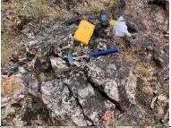 |
SM02 | 414133 | 4799174 | 5 m representative chip sample across outcrop of M-S silicified rhyolite breccia. Probably dome-margin autobreccia or flow lobe from dome. Local stronger silicification aligned NW-SE, ±90°. Sample collected at the same site as LCI sample 16749. Silica locally stained pink. No veins developed. Sample here assayed 151 ppb Au by Perry Durning. |
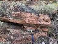 |
SM03 |
414033 | 4799125 | Sample from bold outcrops of silicified, strongly-layered, spherulitic rhyolite. Some horizons look like tuff and others crystalline rhyolite (flow?). Layering at N10°E; 30° W. Locally cut by thin chalcedonic veinlets to 5 mm striking NW. Local strong silicification parallel to the layered horizons. Sample over 6 m by 6 m area. At LCI sample site 16770. |
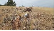 |
SM04 | 414471 | 4799181 | Representative sample across ±1 m rib of silicified rhyolite breccia at N30-35°W; ±90°. Moderately silicified with 30% fine-grained introduced quartz. Host is rhyolite lithic tuff at sample site 101006 (Larry Buchanan). Buchanan's was selected of 3 thin veins; this sample was representative. Durning also sample here. His sample was representative and assayed 58 ppb Au. |
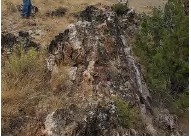 |
SM05 | 413839 | 4799472 | Sample from vein material along the "Number 9" Structure. Possible flow breccia on the margins of a domal flow event. Vein strikes 331°, ~80°NE. Vein thickness is roughly 3.5-4 cm where widest - avg. ~2 cm. Vein is gray-white finely banded(?) chalcedonic silica. Surrounding host rock is illitized, locally brecciated flow banded rhyolite. Flow banding was observed near vertical trending similarly to the vein itself - may represent an upwelling zone within the dome. Multiple samples around this structure ranging from BDL Au to 12 ppb Au (SMR0045) and Sb up to 38 ppm in float (SMR0044). |
| NI 43-101 Technical Report Stockade Mountain Project | Page: 112 | |
| Malheur County, Oregon, USA | ||
| Picture | Sample No |
Easting UTM NAD27z11 |
Northing UTM NAD27z11 |
Description |
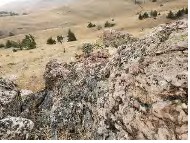 |
SM06 | 414249 | 4799357 | Sample from a small, brecciated structure (?) hosted in silicified rhyolite lithic tuff. Structure trends 336°, 85°NE. Rhyolite is strongly silicified near structures grading out to strong illitization away from the structure. Sample was selected from an approximately 3m structural surface with strong hematite staining. Rock here is strongly hematitic with local limonite on fractures and as pits up to 2-3% after sulfides. Antimony values range from 55 ppm to 203 ppm (the highest from sample 101007 - a select sample from hematite stained breccia). |
12.5 Independent Verification Sampling
12.5.1 Surface Sample Verification
As further verification of geochemical data, Ms. Carroll independently collected six representative samples from outcrops near locations of previous samples collected by LCI to compare the character of mineralization and geochemical results. The samples were collected mostly from rock outcrops but locally from float boulders. The samples generally ranged in weight from 1.5 to 2.5 kg and were placed in 7"X12" cambric sample bags marked with the sample number on the bag. Sample locations were recorded on handheld GPS units, detailed notes were recorded in field books and no sample tags were placed on the ground. The samples were transported by Ms. Carroll from the project site to the offices of American Assay Laboratories, Inc. (AAL) in Sparks, Nevada for processing and analysis. AAL is an ISO 17025 accredited laboratory independent from Austin Gold.
At AAL, samples were prepared for analysis using current industry standard techniques that are suitable for disseminated gold deposits. Upon receipt, the samples were sorted and coded, then placed in drying ovens at 105 degrees Fahrenheit, and when dry, were massed to 0.01 kilogram (kg). The entire sample was jaw crushed to minus 10-mesh (2 mm) particles, and a 300 gram (g) split from a Jones riffle splitter was pulverized to minus 150-mesh (0.1 mm). The 300 g pulp sample was used for fire assay and cyanide- soluble gold analysis.
The pulverized material was digested and analyzed for gold using fire assay fusion and an Induced Coupled Plasma (ICP) finish on a 30-gram assay split (FA-PB30-ICP). Any samples with assay results greater than 10 g/t gold would have been fire assayed on a 30-gram sample (AAL method code Grav Au30) with a gravimetric finish. Data verification of the assay and analytical results were completed to ensure accurate and verifiable results.
Silver and base metals concentrations were analyzed using 2 acid digestion ICP-OES analysis.
AAL includes two levels of quality control for internal assessment of data quality.
1. Internationally certified reference and blank samples, and;
2. 10% of pulp samples have duplicate analysis.
| NI 43-101 Technical Report Stockade Mountain Project | Page: 113 | |
| Malheur County, Oregon, USA | ||
Before AAL reports analytical results, they are compared to internal quality control criteria, and any failures are rectified before the certificate is released to the client.
Rejects and pulps were discarded. Assay results for Au were reported in ppm. Assay certificates are available for these samples and included in Appendix D.
Table 12-3 Assay results from previous Stockade Mountain Project Rock Sampling
| Sample | UTM (NAD27) Location | Au ppm |
Ag ppm |
Sb ppm |
Hg ppm |
|
| East | North | |||||
| 91527 | 414293 | 4798997 | 0.047 | 0.8 | 51 | -99 |
| 16749 | 414132 | 4799175 | 0.151 | 1.4 | 69 | 0.69 |
| 16770 | 414035 | 4799128 | 0.071 | 0.7 | 49 | 2.34 |
| 101006 | 414476 | 4799179 | 0.097 | 0.6 | 110 | -99 |
| SMR0045 | 413839 | 4799474 | 0.012 | -0.5 | 32 | 0.55 |
| 101007 | 414252 | 4799361 | -0.005 | -0.5 | 203 | -99 |
Assay results from the site visit (Table 12-4) show consistency with data generated by La Cuesta and The Electrum Group (Table 12-3).
Table 12-4 Assay results from Stockade Mountain Site Visit
| Sample | UTM (NAD27) Location | Au ppm |
Ag ppm |
As ppm |
Sb ppm |
Hg ppm |
|
| East | North | ||||||
| SM01 | 414293 | 4798997 | 0.008 | -.02 | 30 | 21 | -0.5 |
| SM02 | 414133 | 4799174 | 0.019 | 0.3 | 62 | 12 | 1.4 |
| SM03 | 414033 | 4799125 | 0.061 | 0.2 | 19 | 9 | 1.2 |
| SM04 | 414471 | 4799181 | 0.037 | -0.2 | 146 | 15 | 0.6 |
| SM05 | 413839 | 4799472 | 0.023 | -0.2 | 3 | 4 | 3.0 |
| SM06 | 414249 | 4799357 | 0.007 | -0.2 | 2 | 9 | -0.5 |
| Representative samples collected are selective and do not represent the true mineralization of the prospect. The above assays were determined by American Assay Inc. from representative samples. The samples were crushed and pulverized and a fraction was selected for analysis. Gold was determined using fire assay fusion and an Induced Coupled Plasma (ICP) finish on a 30-gram assay split (FA-PB30-ICP). Any samples assaying over 10 ppm gold would have been re-assayed and completed with a gravimetric finish. Silver and base metals concentrations were analyzed using 2 acid digestion ICP-OES analysis. |
|||||||
While Ms. Carroll was able to determine the general sample locations, she was not able to determine exactly where the samples were taken from. For example, if a small vein was sampled or a small surficial structure was sampled, she was not able to tell which vein or fault was sampled nor did she know what LCI's sampling procedures were. Therefore, while the samples were from the same general area, they are not from the identical locations and did not give duplicate results. While the sampling tells what is occurring at the surface only, it gives a good idea of what is at depth when coupled with structural and alteration mapping.
12.5.2 Current Drill Hole Pulp Sample Verification
As further verification of assay data, random mineralized samples of 13 pulp samples from the 2023- 2024 core drilling program were sent to Paragon Geochemical for analysis. All drill sample pulps are currently stored in Austin's secured shop in Hines, Oregon. The samples were submitted by Mr. Hatch to Paragon Geochemical in March 2026, by U.S. Postal Service for re-assay. Samples were analyzed for gold using method Au-AA30, consisting of a 30 g fire assay with an aqua regia digest and atomic absorption spectroscopy (AAS) finish. This is the same analytical method as previously used for the drilling samples. Assay certificates are available for these samples and included in Appendix E.
| NI 43-101 Technical Report Stockade Mountain Project | Page: 114 | |
| Malheur County, Oregon, USA | ||
Comparison of assay results from the drilling to the 2026 check assays are shown in Table 12-5. Both Austin Gold and the Qualified Person used the same analytical laboratory and assay methodology to ensure comparability of results.
Table 12-5 Check assay results for 2023-2024 core drilling.
| Pulp Sample_No | Au_ppm Original |
Au_ppm Duplicate |
| H584249 | 0.751 | 0.864 |
| H584274 | 0.273 | 0.332 |
| H584314 | 0.049 | 0.058 |
| H584362 | 0.058 | 0.077 |
| H584473 | 0.338 | 0.374 |
| H584589 | 0.075 | 0.091 |
| H584600 | 0.095 | 0.105 |
| H584615 | 1.276 | 1.285 |
| H584647 | 0.026 | 0.031 |
| H584686 | -0.005 | 0.011 |
| H584873 | 0.015 | 0.019 |
| M418006 | 0.067 | 0.074 |
| M418021 | 0.042 | 0.040 |
The comparison of assay values are shown in a scatter plot shown in Figure 12.5-1 below.
The results of the analysis show a 99% correlation between the samples analyzed by Paragon in the 2023-2024 drilling program compared to the independent verification analysis of the samples requested by the Qualified Person.
The thirteen samples targeting mineralized zones are not indicative of the extent of mineralization on the Property. However, the samples provide confirmation that gold mineralization is present at the Stockade Mountain Project.
| NI 43-101 Technical Report Stockade Mountain Project | Page: 115 | |
| Malheur County, Oregon, USA | ||
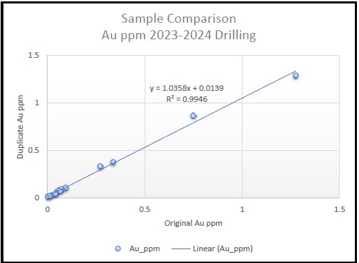
Figure 12.5-1 Comparison of Au ppm Samples from 2023-2024 Drilling
12.6 Summary Statement
Historical surface samples and drill hole assays are not supported by complete QA/QC data by current industry standards; however, Ms. Carroll has reviewed available assay certificates, maps, and supporting documentation and has no reason to doubt the general integrity of the historical data.
Austin Gold implemented QA/QC procedures for its 2023/2024 drilling program, and assay certificates for this work were reviewed as part of this report. Verification sampling and check assays completed by Ms. Carroll, including re-analysis of selected pulp samples, demonstrate results that are broadly consistent with both historical data and the current drilling results, within the limitations described herein.
Based on the data review, verification procedures, and the results of current QA/QC programs, verification sampling, and check assays, the Qualified Person considers the database to be adequate for the purposes of this technical report, including geological interpretation and evaluation of the exploration potential of the Property.
| NI 43-101 Technical Report Stockade Mountain Project | Page: 116 | |
| Malheur County, Oregon, USA | ||
13 MINERAL PROCESSING AND METALLURGICAL TESTING
The following information is a compilation of historical data. Austin Gold has done no metallurgical test work.
13.1 Phelps Dodge
In 1991, limited cyanide shake tests were performed on five mineralized drill pulps. Results from cyanide shake tests shown in Table 13-1 are erratic but generally show no indication of encapsulation or refractory mineralization. Possible nugget effect was indicated by high recoveries in some samples (Canby, 1991).
Table 13-1 Cyanide Shake Test Results
| Hole No. | Rock Type | Depth | Fire/AA Grade (opt) |
Recovered Grade (opt) |
Recovery |
| STKDH-9 | Sil. Bx | 235' - 245' | .127 | .162 | 128% |
| Sil. Rhyolite | 315' - 320' | .043 | .017 | 40% | |
| Vnd. Rhyolite | 365' - 370' | .019 | .037 | 195% | |
| STKDH-12 | Argillized, | 370' - 380' | .015 | .013 | 85% |
| Weakly | |||||
| Silicified Tuff |
| NI 43-101 Technical Report Stockade Mountain Project | Page: 117 | |
| Malheur County, Oregon, USA | ||
14 MINERAL RESOURCE ESTIMATE
There has been insufficient exploration on the Stockade Mountain Project to estimate a 43-101 compliant mineral resource.
15-22 ADVANCED PROPERTY
The Stockade Mountain Project does not have mineral reserves and is therefore not considered an Advanced Property under NI 43-101. As such, the following sections are not applicable and have not been included in this report:
15: Mineral Reserve Estimates
16: Mining Methods
17: Recovery Methods
18: Project Infrastructure
19: Market Studies and Contracts
20: Environmental Studies, Permitting, and Social or Community Impact
21: Capital and Operating Costs
22: Economic Analysis
No preliminary economic assessment (PEA), pre-feasibility study (PFS), or feasibility study (FS) has been prepared for this Property, and no mineral reserves have been declared.
| NI 43-101 Technical Report Stockade Mountain Project | Page: 118 | |
| Malheur County, Oregon, USA | ||
23 ADJACENT PROPERTIES
In accordance with NI 43-101, relevant information concerning adjacent properties may be included in a technical report provided that: (i) the information has been publicly disclosed by the owner or operator of the adjacent property; (ii) the source of the information is identified; (iii) the Qualified Person is unable to verify the information; (iv) the report clearly distinguishes between information from the adjacent property and the subject property; and (v) any disclosed historical mineral resource or mineral reserve estimates are identified as such and presented in accordance with the Instrument.
For the purposes of this report, an adjacent property is defined as a property in which the issuer does not have an interest, that has a boundary reasonably proximate to the Stockade Mountain Property, and that has geological characteristics similar to those of the Stockade Mountain Property.
The following deposits and prospects occur within the Miocene Lake Owyhee volcanic field and surrounding structural corridors of eastern Oregon and are considered geologically relevant to the Stockade Mountain Project: Grassy Mountain, Frost, Quartz Mountain, Red Butte, and Drewsey. Figure 23-1 shows their locations relative to the Stockade Mountain Property.
The information regarding adjacent properties presented below has been obtained from publicly available sources and has not been independently verified by the Qualified Persons. The Qualified Persons are unable to verify the accuracy of such information, and the information is not necessarily indicative of the mineralization on the Stockade Mountain Property.
| NI 43-101 Technical Report Stockade Mountain Project | Page: 119 | |
| Malheur County, Oregon, USA | ||
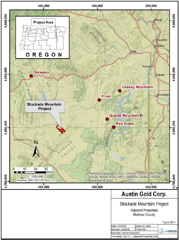
Figure 23-1 Adjacent Properties
| NI 43-101 Technical Report Stockade Mountain Project | Page: 120 | |
| Malheur County, Oregon, USA | ||
23.1 Grassy Mountain
The Grassy Mountain deposit is located approximately 40 miles northeast of Stockade Mountain in Malheur County, Oregon. The property comprises approximately 8,200 acres located about 22 miles south of Vale, Oregon, and roughly 70 miles west of Boise, Idaho. Paramount Gold Nevada Corp. (NYSE American: PZG), through its wholly owned subsidiary Calico Resources USA Corp., controls the Grassy Mountain project.
Grassy Mountain is described as a low-sulfidation epithermal hot spring gold-silver deposit formed during fluvio-lacustrine deposition of the mid-Miocene Grassy Mountain Formation within the Lake Owyhee volcanic field. The deposit reportedly extends approximately 1,900 feet along a N60°E to N70°E axis, up to 2,700 feet northwest-southeast, and as much as 1,240 feet vertically.
In October 2022, Paramount filed an S-K 1300 Technical Report Summary supporting a Feasibility Study for a proposed underground gold mine and indoor processing facility at Grassy Mountain (Ausenco Engineering Canada Inc., 2022). The study reports an estimated 8-year mine life with total production of approximately 362,000 ounces of gold and 425,000 ounces of silver, with average annual production of approximately 47,000 ounces of gold and 55,000 ounces of silver.
On January 29, 2026, Paramount Gold announced receipt of federal approval from the Bureau of Land Management for the Grassy Mountain Gold Project (Bureau of Land Management, 2026).
23.2 Frost Project
The Frost Project consists of 84 unpatented lode claims covering approximately 1,730 acres in southeastern Malheur County, Oregon. The property lies approximately 12 miles west of Grassy Mountain and approximately 30 miles northeast of Stockade Mountain.
The Frost area is situated within Miocene volcanic terrain known to host high-grade gold mineralization in low-sulfidation (quartz-adularia) veins and in pervasively altered and brecciated sedimentary units. According to Paramount Gold Nevada Corp. (2020), geologic mapping identified a fossil hot spring system interpreted to be similar in style to Grassy Mountain. Mineralization is associated with steeply dipping northwest-trending fracture zones developed within Middle to Late Miocene rhyolites and basalts. Vein material consists of banded to vuggy chalcedony-quartz-adularia with smectite, hematite, and native gold.
Structural controls reportedly include north-south to N10°W-trending faults and N45°W-trending faults. The known mineralized vein is associated with a N45°W-trending structure interpreted as a principal fluid conduit.
Historical drilling conducted between 1989 and 1990 reportedly intersected near-surface gold mineralization including intervals such as 1.5 m grading 20 g/t Au, 4.6 m grading 14.5 g/t Au, 4.6 m grading 8.0 g/t Au, and 7.6 m grading 1.2 g/t Au. In 2022, Paramount reported reverse circulation drilling intersected gold grades up to 14.4 g/t Au from a 13-hole program totaling approximately 9,010 feet (Paramount Gold, 2022). CSAMT geophysical surveys were also reported to have confirmed prospective targets (Paramount Gold Nevada Corp, 2020).
23.3 Quartz Mountain
The Quartz Mountain deposit is located approximately 27 miles northeast of Stockade Mountain in Malheur County, Oregon. The property has been controlled by Volcanic Gold & Silver LLC since 2017.
| NI 43-101 Technical Report Stockade Mountain Project | Page: 121 | |
| Malheur County, Oregon, USA | ||
Quartz Mountain consists of lacustrine and fluvial sedimentary sequences separated by basalt flows. Faulting contemporaneous with basalt emplacement is interpreted to have formed graben basins subsequently filled by sediments. Multiple phases of hot spring activity and opaline sinter development are reported along northwest-trending faults. Gold mineralization is described as occurring both in high- level stockworks veins formed during boiling and in near-surface disseminated zones formed by mixing of hydrothermal and surface waters. Silicification and peripheral argillic alteration are characteristic features.
More than 175 drill holes have reportedly been completed on the property. A mineral resource estimate compliant with NI 43-101 standards at the time of preparation was completed by MineFill Services Inc. in 2006 based on historical data (Stone & Daly, 2006). That estimate reported indicated mineral resources above a cutoff grade of 0.01 oz/ton (0.34 g/t) Au totaling 16.55 million short tons (15.01 million tonnes) grading 0.017 oz/ton (0.58 g/t) Au and 0.213 oz/ton (7.29 g/t) Ag. Exploration targets are the same as for Stockade Mountain - potential high grade veins occurring below the near-surface stockworks mineralization. The Qualified Person has not independently verified this estimate and expresses no opinion as to its current validity.
23.4 Red Butte
The Red Butte gold prospect is located approximately 40 miles south of Vale and 30 miles east of Stockade Mountain within the Lake Owyhee volcanic field of eastern Oregon. Red Butte is described as a well-preserved sediment-hosted fossil hot spring system characterized by siliceous hot spring sinter. Red Butte is described as a well-preserved sediment-hosted fossil hot spring system characterized by siliceous hot spring sinter, intense steam-heated argillic alteration, and a hydrothermal eruption crater approximately 50 meters wide (Evans, 1986).
Mineralization is associated with north- and northwest-striking faults within Miocene volcaniclastic sediments of the Deer Butte Formation. Four stages of hydrothermal activity have been described, including early silicification, quartz-adularia vein formation related to boiling, steam-heated alteration near the paleosurface, and a final hydrothermal eruption event (Zimmerman & Larson, 1994). Four stages of mineralization have been recognized at Red Butte. An early stage of silicification (stage I) is followed by periods when boiling hydrothermal fluids formed quartz-adularia veins below the paleosurface and steam heated fluids produced intense argillic alteration at the paleosurface (stages II and III). The final stage of hydrothermal activity (stage IV) is marked by a large hydrothermal eruption, which produced the crater exposed on the rim of the butte. Au mineralization occurred at the peak of hydrothermal activity in response both to boiling and mixing of the boiling hydrothermal fluid with surficial steam-heated waters.
23.5 Drewsey
The Drewsey gold prospect is located approximately 36 miles northwest of Stockade Mountain in Harney County, Oregon. The prospect lies within a broad north-northwest-trending structural corridor referred to as the Stinking Water Mountains structural corridor, a Miocene-age fault zone affecting basalts, felsic volcanic rocks, and sedimentary units.
Silicification and clay alteration of rhyolite tuff, tuffaceous siltstone, and tuffaceous mudstone are interpreted to be related to felsic intrusive domes and plugs assigned to the Drewsey Formation (Gregory, 1962). These intrusions are considered a likely heat source for widespread hot spring-style alteration and mineralization in the district.
| NI 43-101 Technical Report Stockade Mountain Project | Page: 122 | |
| Malheur County, Oregon, USA | ||
Gold anomalies have been reported over an open-ended area of approximately 6 square kilometers southeast of the Drewsey Grange. Geochemical anomalies include elevated As, Hg, Mo, and Sb. Elevated molybdenum values have been interpreted to suggest the possible presence of a mineralizing felsic intrusive at depth (Hillemeyer & Durning, 2014).
These adjacent properties collectively demonstrate that the Miocene Lake Owyhee volcanic field and associated structural corridors host multiple low-sulfidation epithermal gold systems characterized by hot spring sinter development, silicification, argillic alteration, and structurally controlled vein emplacement. While the Stockade Mountain Property shares many of these regional geological characteristics, the presence of mineralization on adjacent properties is not necessarily indicative of mineralization on the Stockade Mountain Property.
| NI 43-101 Technical Report Stockade Mountain Project | Page: 123 | |
| Malheur County, Oregon, USA | ||
24 OTHER RELEVANT DATA
There is no other relevant information that is not included elsewhere in this report.
| NI 43-101 Technical Report Stockade Mountain Project | Page: 124 | |
| Malheur County, Oregon, USA | ||
25 INTERPRETATION & CONCLUSIONS
This section summarizes the key interpretations and conclusions derived from the technical work completed on the Stockade Mountain Project, as documented in the preceding sections of this Technical Report. It integrates the findings of the Qualified Persons related to property status, exploration, drilling, metallurgical information, and data quality to provide an overall assessment of the Project's current status.
The Stockade Mountain Project is a gold and silver exploration-stage property that has been the subject of multiple exploration programs since the late 1980s, including work by BHP-Utah, Phelps Dodge, and Placer Dome. Following a period of limited activity, exploration resumed in 2014 with work conducted by La Cuesta International and The Electrum Group, which included geological mapping and surface sampling that identified areas of anomalous gold mineralization and contributed to the current understanding of the Project. More recent work by Austin Gold has included drilling that has confirmed the presence of gold mineralization within the project area.
Exploration work completed to date has identified widespread alteration and gold mineralization within the project area, including zones such as Opal Hill and the Craters Area. Gold and associated pathfinder elements, including arsenic, antimony, and mercury, have been identified in surface samples and historical drilling. The project is interpreted to represent a hydrothermal system consistent with low- sulfidation epithermal mineralization. Current exploration programs are focused on evaluating the distribution and characteristics of mineralization within this system.
25.1 Property Status and Land Position
The Stockade Mountain Project consists of a group of unpatented federal lode mining claims leased under a long-term mining agreement. The Project is located in Malheur County, Oregon, and is controlled by Austin Gold Corp.
25.1.1 Mineral Tenure and Land Control
The Stockade Mountain Project is comprised of unpatented lode mining claims located on federal lands administered by the Bureau of Land Management. The claims held by Bull Mountain Resources, LLC and those staked by Austin American Corporation are recorded with the BLM, and maintenance fees have been paid through the current filing period. Based on available BLM records, the claims appear to be in good standing, providing the Company with the right to explore and develop mineral resources on the Property, subject to applicable federal regulations.
A portion of the claims staked in 2024 are currently listed in the BLM database as "Filed" and have not yet been adjudicated. While these claims are included within the area of interest defined in the agreement with Bull Mountain Resources, their status introduces a level of administrative uncertainty until final adjudication is completed.
Overall, the Company has established control of the Property through unpatented mining claims, which is sufficient to support ongoing exploration activities.
25.1.2 Royalties, Agreements, and Encumbrances
The Company holds its interest in the Stockade Mountain Project through a mineral lease and option agreement with Bull Mountain Resources, LLC, which provides the right to earn a 100% operating interest in the Property, subject to the terms of the agreement. The agreement includes work commitments, pre-production payments, and a retained net smelter return royalty.
| NI 43-101 Technical Report Stockade Mountain Project | Page: 125 | |
| Malheur County, Oregon, USA | ||
The retained royalty and ongoing payment obligations represent typical encumbrances for an exploration-stage property and do not preclude continued exploration activities. The amendment to the agreement removing the minimum drilling requirement reduces near-term work obligations and provides additional flexibility in advancing the Project.
No other material encumbrances affecting the Company's ability to explore the Property have been identified based on the available information.
25.1.3 Surface and Water Rights
The project is located on federal lands administered by the Bureau of Land Management, where mineral exploration activities are permitted subject to surface management regulations. Existing land use includes grazing under BLM-administered allotments, which requires coordination with permit holders to avoid conflicts during exploration activities but does not prevent access to the Property.
Water availability within the project area is limited due to the semi-arid environment. Springs may provide a source of water for exploration drilling; however, additional water will be required for future programs. The Company has received permission to drill a water well for exploration purposes and plans to develop this source to support future drilling activities.
Based on available information, surface use and water availability are manageable for exploration-stage activities, although water supply will require development to support continued work.
25.1.4 Encumbrances and Legal Considerations
There are no known environmental liabilities identified that would adversely impact the ability to conduct exploration activities on the Property. Historical disturbances associated with previous exploration programs have been reclaimed, and the extent of any remaining reclamation responsibility is not known.
The project is located on BLM-administered lands, and exploration activities are subject to federal and state permitting requirements. The Company has obtained the necessary permits to conduct the currently approved exploration program, including a BLM Exploration Notice and a DOGAMI Exploration Permit, and has provided the required reclamation bonding.
Portions of the project area are located within a BLM-designated Area of Critical Environmental Concern, and the Project is situated within mapped Greater Sage-Grouse habitat, with an active golden eagle territory identified within approximately two miles of the Property boundary. These factors indicate that environmental and wildlife considerations will need to be addressed in future permitting and may influence the timing and scope of exploration activities.
Based on the information currently available, permitting requirements are understood and have been met for the approved exploration program. However, additional environmental review and permitting may be required for future activities that expand beyond the currently authorized disturbance limits.
25.2 Geology and Mineralization
The Stockade Mountain Project is underlain by Miocene-aged volcanic rocks of the Owyhee Upland, consisting predominantly of rhyolitic ash-flow tuffs, tuffaceous sedimentary rocks, and associated basaltic units. At the property scale, the geology is characterized by weakly to strongly welded rhyolitic ash-flow sheets and tuff units that have been intruded by domes of fine-grained porphyritic rhyolite. These domes form elongate bodies and are associated with carapace and frontal breccias developed during emplacement. The volcanic stratigraphy is generally shallowly dipping to the west and is locally interbedded with air-fall tuffs and volcaniclastic units.
| NI 43-101 Technical Report Stockade Mountain Project | Page: 126 | |
| Malheur County, Oregon, USA | ||
Structural features at the Property are dominated by northwest-trending faults and fracture zones that cut both the intrusive rhyolite domes and the surrounding tuffaceous units. These structures form steeply dipping planar zones and are interpreted to have acted as conduits for hydrothermal fluids. Brecciation associated with these structures is common and forms vein-like bodies consisting of angular to subrounded fragments cemented by silica minerals. Post-mineral faulting is also present and has locally displaced mineralized units.
Mineralization at Stockade Mountain is associated with a large, gold- and silver-bearing low-sulfidation hydrothermal system developed in a near-surface paleo-hot springs environment. Gold and silver mineralization is accompanied by anomalous concentrations of pathfinder elements including arsenic, antimony, and mercury. Alteration is characterized by widespread silicification, including opal, chalcedony, and agate, as well as argillic alteration manifested as illitization of host rocks. Silicification is most intense along structural zones and within permeable breccia units, where hydrothermal fluids have deposited silica both within fracture zones and along bedding planes.
Hydrothermal alteration and mineralization are spatially associated with rhyolite domes and their associated breccia zones, particularly along dome margins where permeability is enhanced. Silicified breccia zones and chalcedony-opal veins occur throughout the system and commonly exhibit limited banding and extensive brecciation. Mineralization is present at surface but is not uniformly distributed, and historical and recent drilling indicates that gold and silver values increase with depth below the paleosurface.
A limitation to the current geologic understanding of the Property is the limited extent of outcrop exposure, which restricts direct observation of lithologic contacts and structural relationships. As a result, interpretations of geology and mineralization are supported in part by historical drill data and more recent core drilling, which confirms the general lithologic framework and the presence of stockwork and breccia-style mineralization within the hydrothermal system. Geophysical data from the 2025 Controlled Source Audio-frequency Magnetotellurics (CSAMT) survey supports the interpretation of subsurface structural features and the distribution of silicified breccias and rhyolitic dome-related units at depth, but also shows complexity of the subsurface geology that is not understood.
25.3 Exploration and Drilling,
25.3.1 Exploration
Historical exploration at the Stockade Mountain Project has been conducted intermittently since the late 1980s and includes geological mapping, extensive surface geochemical sampling, and limited geophysical surveys completed by multiple operators. Early work by Carlin Gold, BHP-Utah, Phelps Dodge, and Placer Dome identified areas of gold anomalism associated with opalite-chalcedony alteration through soil and rock geochemistry and reconnaissance to detailed mapping. Subsequent work by La Cuesta International and the Electrum Group expanded the geological understanding of the Property through additional mapping and surface sampling, recognizing the system as a high-level low-sulfidation epithermal gold system. Later compilation and analysis by P2 Gold integrated historical geochemical, geological, and geophysical datasets into a consolidated framework for evaluating mineralization patterns and structural relationships. Collectively, this work demonstrates the presence of a gold-bearing hydrothermal system with associated surface geochemical anomalies and alteration within the project area.
| NI 43-101 Technical Report Stockade Mountain Project | Page: 127 | |
| Malheur County, Oregon, USA | ||
Recent exploration work completed by Austin Gold since acquiring the Property in May 2022 has included compilation and review of historical datasets, field evaluation, and geophysical interpretation. Historical induced polarization-resistivity and aeromagnetic-radiometric survey data were reviewed and reinterpreted by consulting geophysicists, leading to the conclusion that earlier surveys were not effective for imaging structures at target depths. In response, a Controlled Source Audio-frequency Magnetotellurics (CSAMT) survey was designed and completed during November and December 2025 to improve subsurface imaging of structural features. The CSAMT survey consisted of 17 lines totaling approximately 40.8 line-km, providing resistivity data to depths of approximately 300 to 400 meters. Interpretation of the CSAMT data has identified zones of high resistivity associated with silicified breccias and rhyolitic domes, as well as structural features that may represent potential fluid pathways within the hydrothermal system.
25.3.2 Drilling
Historical drilling at the Stockade Mountain Project was conducted between 1990 and 1993 by Carlin Gold, BHP-Utah, Phelps Dodge, and Placer Dome, and focused on testing near-surface gold mineralization associated with opalite-chalcedony alteration. Available records indicate that a total of 57 reverse circulation drill holes were completed for approximately 23,130 feet within the project area and adjacent lands. Drilling programs were designed to evaluate geochemical anomalies, mapped structures, and zones of alteration identified through surface exploration. Results from these programs confirmed the presence of gold mineralization within the project area and provided initial subsurface information used to define target areas for further evaluation.
During the 2023-2024 program, Austin Gold completed three diamond drill holes totaling approximately 2,436 feet within the Opal Hill/Number 9 Vein target area to test mineralization at depth beneath previously identified stockwork zones. Results from this drilling confirm that the mineralizing system at Stockade Mountain is robust and contains significant gold grades, including higher-grade intervals such as 8.19 g/t over 4 feet and 9.32 g/t over 2.7 feet, along with additional zones of mineralization. These results demonstrate the presence of gold mineralization within the tested target area and support the potential for additional mineralization within the system.
25.4 Mineral Processing and Metallurgical Testing
No metallurgical test work has been conducted by Austin Gold on the Stockade Mountain Project. Available metallurgical information is limited to historical test work completed by previous operators.
Limited cyanide shake tests conducted by Phelps Dodge in 1991 on mineralized drill pulps produced variable results but generally indicated no evidence of refractory mineralization. Preliminary leachability testing conducted by Placer Dome in 1993 on selected drill samples indicated that a portion of the gold is cyanide leachable, with reported recoveries ranging from approximately 65% to 80% under varying test conditions.
| NI 43-101 Technical Report Stockade Mountain Project | Page: 128 | |
| Malheur County, Oregon, USA | ||
25.5 Sample Quality and Data Confidence
25.5.1 Sample Preparation, Analyses, and Security
Sample preparation, analytical procedures, and sample security for the Stockade Mountain Project have been conducted by multiple operators over time, with varying levels of documentation. Historical programs utilized a range of independent commercial laboratories, including Chemex, Bondar-Clegg, American Assay Laboratories, and Geochemical Services Inc., with generally limited information available regarding sample preparation methods, chain of custody, and quality control procedures. Where documented, samples were typically dried, crushed, split, and pulverized prior to analysis using standard industry methods. Analytical work included fire assay for gold and multi-element analysis using ICP and other techniques, although detailed methodologies and quality control practices are not consistently reported for historical programs.
More recent work conducted by La Cuesta International, the Electrum Group, and Austin Gold Corp. utilized independent commercial laboratories, including ALS Minerals, Paragon Geochemical, and Bureau Veritas, all of which operate under ISO/IEC 17025 accreditation standards. Sample preparation for these programs included drying, crushing, splitting, and pulverizing using established laboratory protocols. Gold analyses were performed using fire assay methods with atomic absorption or gravimetric finishes, and multi-element analyses were conducted using ICP-based methods following multi-acid digestion.
For the 2023-2024 drilling program conducted by Austin Gold, drill core was transported to a secure storage facility, where it was logged, photographed, and sampled. Samples were prepared and analyzed by Paragon Geochemical using standardized preparation and fire assay procedures. Quality control measures implemented by Austin Gold included the insertion of blanks, certified reference materials, rig duplicates, coarse reject duplicates, and the use of an independent umpire laboratory for check assays. Samples were maintained under the control of company personnel or contractors during transport and storage.
25.5.2 Data Support and Reliability
The data used in this report consists of historical exploration data and more recent drilling completed by Austin Gold Corp. Documentation for historical sampling, analytical methods, and quality control procedures is incomplete, and detailed records of sample preparation, chain of custody, and QA/QC protocols are not consistently available for earlier programs. Analytical work for these programs was conducted by independent commercial laboratories that were widely used within the mining industry at the time.
More recent exploration and drilling programs include documented sample preparation procedures, analytical methods, and quality control measures. Laboratories utilized for recent work are independent and accredited under ISO/IEC 17025 standards, and quality control programs include the use of blanks, standards, duplicates, and check assays.
Based on the available information, the dataset comprises a combination of historical and recent data with differing levels of documentation. These data are considered adequate for supporting exploration- stage evaluation of the Property.
| NI 43-101 Technical Report Stockade Mountain Project | Page: 129 | |
| Malheur County, Oregon, USA | ||
25.6 Data Validation
Data verification for the Stockade Mountain Project consisted of review and comparison of historical and current datasets, including technical reports, maps, assay certificates, and drill hole data provided by Bull Mountain Resources and Austin Gold. Historical data were previously compiled and verified as part of earlier work, including comparison of digital datasets to original assay certificates and available source documents. The information reviewed is derived from multiple operators and is incomplete in some instances; however, the available data were examined and reconciled where possible.
Assay certificates for the current drilling program were reviewed, and selected drill hole assay data were compared against original laboratory certificates with no discrepancies identified. Verification of the drill hole database included checks of collar, survey, assay, and geological data for consistency, completeness, and errors such as overlapping intervals or depth inconsistencies, with no errors identified in the populated datasets.
Independent verification sampling was conducted through collection and analysis of surface samples and re-analysis of selected drill core pulp samples. Analytical results from verification sampling are consistent with previously reported data within expected ranges for the type of mineralization present. Check assay results for current drilling samples show a high degree of correlation between original and verification analyses.
Based on the data review, verification procedures, and available QA/QC information, the data are considered adequate for use in this technical report.
25.7 Target Areas and Potential
Geological, geochemical, and historical drilling data indicate that the principal target areas identified on the Stockade Mountain Project are as follows:
25.7.1 Opal Hill / Number 9 Vein Discovery Area
The Opal Hill / Number 9 Vein area represents the most extensively explored and best-defined zone of gold mineralization identified on the Stockade Mountain Project. The target area is centered on a rhyolite dome where mineralization is associated with a series of northwest-trending opal/chalcedony and breccia vein structures hosted within altered intrusive rhyolite and associated breccia units. The Number 9 Vein zone can be traced discontinuously for at least 1,200 meters along strike and consists of multiple subparallel veins distributed across a zone up to approximately 75 meters in width, with individual veins ranging from less than one meter to several meters in thickness.
Historical drilling completed by Phelps Dodge and Placer Dome defined gold mineralization within the dome, with mineralized intervals occurring over broad thicknesses. Drilling results indicate that mineralization is present throughout the dome and extends to the limits of drilling. Core drilling by Austin Gold confirmed the earlier interpretations that the gold mineralization occurs as a stockworks of small quartz/chalcedony and breccia veins withing largely silicified rhyolite. Mineralization is not uniformly distributed, and zones of higher-grade mineralization are separated by intervals of lower- grade or weakly mineralized material.
Geological relationships observed in mapping and drilling suggest that mineralization is structurally controlled and localized along zones of enhanced permeability associated with the margins of the rhyolite dome and related breccia units. The distribution of mineralization, together with the presence of stockwork and breccia-style veining, indicates that the Opal Hill area represents a significant zone of hydrothermal fluid flow within the broader mineralized system. Geophysical data from the 2025 CSAMT survey identify a corresponding zone of high resistivity associated with the rhyolite dome and adjacent structural features, supporting the interpretation of fluid pathways and the distribution of mineralization at depth.
| NI 43-101 Technical Report Stockade Mountain Project | Page: 130 | |
| Malheur County, Oregon, USA | ||
25.7.2 The Craters Target Area
The Craters area represents a zone of extensive brecciation and hydrothermal activity located near the margins of the rhyolite dome and associated breccia units. This area is characterized by multiple hydrothermal vent features, expressed at surface as shallow depressions surrounded by accumulations of ejected breccia fragments. These vent-related breccias consist of angular to subrounded fragments of rhyolitic material that have been strongly silicified and cemented by opal and chalcedony.
Geological mapping indicates that the Craters area contains widespread silicified breccia units and associated alteration developed within both domal breccias and interbedded tuffaceous units. Silicification is most intense adjacent to northwest-trending structural zones, where chalcedony and opal deposition have occurred within both fracture zones and permeable stratigraphic horizons. The distribution of alteration and brecciation suggests that hydrothermal fluids were focused along structural pathways and laterally along permeable units within the volcanic sequence.
Historical drilling within the Craters area has intersected zones of stockwork veining and silicification similar in character to those observed within the Opal Hill area; however, reported gold values are generally lower and less continuous. Drilling results indicate that mineralization is present but variable, and that the distribution of mineralization may be influenced by host rock permeability and proximity to structural conduits. Geophysical data from the 2025 CSAMT survey identify moderately high-resistivity feeder zones beneath the vent area, supporting the interpretation of vertically oriented structures that may have acted as pathways for hydrothermal fluids.
25.7.3 Vents and Dome Target Area
The Vents and Dome area is considered to be a secondary target area and comprises zones of silicification and opalization developed within a rhyolite dome and associated carapace breccia, along with features interpreted as hydrothermal vent-related activity. Surface exposures include areas of strongly altered rhyolite and breccia, where opal and chalcedony replacement have occurred within both intrusive and volcaniclastic units.
Geological relationships indicate that this area represents a near-surface expression of hydrothermal activity associated with the broader system. Alteration is developed within both the dome and adjacent breccia units and is spatially associated with structural zones and permeable lithologies. The presence of vent-related features and widespread silicification indicates that hydrothermal fluids were active in this area and resulted in localized zones of intense alteration.
Geophysical data, including airborne radiometric surveys, indicate anomalous potassium values within this area, which may reflect the presence of potassium-bearing alteration minerals within the hydrothermal system. This information supports the interpretation that the Vents and Dome area represents a zone of hydrothermal alteration associated with the broader mineralized system. Geophysical data from the 2025 CSAMT survey identify a zone of elevated resistivity at depth beneath this area, consistent with silicified rhyolitic units and supporting the interpretation of a subsurface intrusive body and associated hydrothermal alteration.
| NI 43-101 Technical Report Stockade Mountain Project | Page: 131 | |
| Malheur County, Oregon, USA | ||
25.8 Risks and Uncertainties
The Stockade Mountain Project is an exploration-stage property, and the extent, continuity, and grade of mineralization are not fully defined. Historical drilling and limited recent drilling confirm the presence of gold mineralization; however, the distribution and continuity of mineralization remain uncertain and will require additional exploration to evaluate.
The project database consists of a combination of historical and recent data. Documentation of sample preparation methods, analytical procedures, and quality control for historical programs is incomplete, which introduces uncertainty in portions of the dataset. Although the available information has been reviewed and verified where possible, the historical dataset is not complete and may contain unrecognized errors or omissions.
Metallurgical information for the Project is limited to historical test work, and no metallurgical testing has been conducted by Austin Gold. Additional metallurgical testing will be required to evaluate recovery characteristics and processing considerations for mineralized material.
The project is located on federal lands administered by the Bureau of Land Management, and exploration activities are subject to federal and state permitting requirements. Portions of the project area are located within a designated Area of Critical Environmental Concern and within mapped Greater Sage-Grouse habitat, which may influence the timing and scope of future exploration activities.
Water availability in the project area is limited, and additional water sources will be required to support expanded exploration or development activities.
The unpatented mining claims located by Austin American Corporation in 2024 are currently listed as "Filed" and have not yet been adjudicated by the Bureau of Land Management. This introduces some uncertainty regarding final claim status; however, the risk is considered to be very low.
Future exploration, development, and potential mining activities are also subject to economic factors, including fluctuations in metal prices, operating costs, and capital requirements, which may affect the economic viability of the Project.
25.9 Opportunities
The Stockade Mountain Project has undergone multiple phases of exploration by several operators, including geological mapping, geochemical sampling, and drilling, which have identified a gold-bearing hydrothermal system within the project area. Historical and recent drilling have confirmed the presence of significant gold mineralization associated with alteration and structural features, indicating that the system is mineralized and warrants further evaluation.
The current drilling program conducted by Austin Gold is the first attempt to explore for higher grade veins interpreted to occur below the documented near-surface gold-bearing stockworks mineralization. Additional exploration drilling provides an opportunity to expand upon existing results and define higher grade economic mineralized zones that would be minable by underground mining methods.
Surface geochemical sampling and mapping have identified areas of anomalous gold and associated pathfinder elements, which remain only partially tested by drilling. These areas provide opportunities for additional exploration, targeting and evaluation. Recent CSAMT geophysical data provides improved definition of subsurface structural features and resistivity contrasts, supporting refinement of drill targeting within these areas.
| NI 43-101 Technical Report Stockade Mountain Project | Page: 132 | |
| Malheur County, Oregon, USA | ||
The project is located on federal lands where exploration activities are permitted, and the Company has obtained the necessary permits to conduct current exploration programs. Existing infrastructure and access allow for continued exploration activities, subject to regulatory requirements.
Based on the available data, the Project provides opportunities for further exploration to evaluate the extent and characteristics of mineralization within the hydrothermal system.
25.10 Summary and Conclusion
The potential for the discovery of gold and silver mineralization within the Stockade Mountain Project area is considered to be favorable, and further exploration work is warranted to better define and test the identified exploration targets. The Qualified Persons have considered the previously described risks and are satisfied that the Stockade Mountain Project contains sufficient evidence of mineralization to constitute an exploration property of merit at this time. There is no certainty that the present exploration effort will result in the identification of a mineral resource or that any mineral resource that might be discovered will prove to be economically recoverable.
| NI 43-101 Technical Report Stockade Mountain Project | Page: 133 | |
| Malheur County, Oregon, USA | ||
26 RECOMMENDATIONS
The Qualified Persons have reviewed the previous Stockade Mountain Project data, verified the drill- hole database, attained an understanding of the extent of historical QA/QC procedures implemented, and completed a site visit. Based on this work, the Qualified Persons consider the Stockade Mountain Project to be a project of merit that warrants further exploration and recommend that a US$1,523,000 work program (including land holding costs) be conducted to advance and refine the exploration targets identified by previous work on the Project.
26.1 Scope of Work
It is recommended that exploration for economic high-grade gold and silver vein deposits within the Stockade Mountain Project area be advanced through an integrated program of additional geological mapping, data compilation, target refinement, and drilling. The recommended exploration program is designed to build upon the substantial existing geological, geochemical, geophysical, and drilling database to refine drill targets and test for the presence of high-grade mineralization within structurally controlled zones at depth.
The program will commence with continued compilation and interpretation of historical data, including integration of recently completed CSAMT geophysical data to assist in delineating structures that may host mineralization. Additional geological evaluation, including field verification and mapping where required, will be undertaken to support target development. These efforts are intended to improve confidence in drill targeting given the narrow and structurally controlled nature of the mineralization.
Permitting activities will be advanced as warranted, including preparation of an Exploration Plan of Operations to support potential future drilling programs and minimize delays in subsequent exploration phases.
The primary component of the recommended exploration program is an approximately 12,000-foot reverse circulation (RC) drilling campaign designed to test the highest priority targets. Drilling activities are subject to seasonal environmental restriction periods. A water well is planned to be drilled and completed to support drilling operations. The drilling program is designed to evaluate the presence, continuity, and grade of mineralization within the targeted structural zones and to provide data for ongoing geological interpretation.
| NI 43-101 Technical Report Stockade Mountain Project | Page: 134 | |
| Malheur County, Oregon, USA | ||
26.2 Budget
The estimated budget for the recommended exploration program is summarized in Table 26-1 (in US$):
Table 26-1 Proposed Budget
| Scope of Work | Total |
| Land Costs | $119,357 |
| Data Compilation / GIS / Modeling | $60,000 |
| Geological (mapping, etc.) | $32,000 |
| Surface Geochemistry | $2,000 |
| Geophysics | $14,000 |
| Permitting | $120,000 |
| Shop / Core storage | $12,000 |
| Drilling - RC | $967,143 |
| Drilling - Water Well | $140,000 |
| Logistics / Planning / Management | $40,000 |
| Misc. expenses and costs | $16,500 |
| Totals | $1,523,000 |
| NI 43-101 Technical Report Stockade Mountain Project | Page: 135 | |
| Malheur County, Oregon, USA | ||
27 REFERENCES
27.1 Bibliography
Albinson, T. N. (2001). Controls on formation of low-sulfidation epithermal deposits in Mexico-Constraint from fluid inclusion and stable isotope data. Society of Economic Geologists Special Publication 8, 1-32.
Ausenco Engineering Canada Inc. (2022). Grassy Mountain Project S-K 1300 Technical Report Summary on Feasibility Study. Ausenco Engineering Canada Inc.
Austin Gold Corp. (2026). Consolidated Financial Statements for the Years Ending December 31, 2025, 2024 and 2023. Austin Gold Corp.
Austin Gold Corp. (2022). Condensed Consolidated Interim Financial Statements for the Quarter Ending June 30, 2022. Austin Gold Corp.
Beis, L. (2020, February 27). Interior releases updated sage-grouse plans. Retrieved from The Wildlife Society: https://wildlife.org/interior-releases-updated-sage-grouse-plans/
Berger, B. (1986). Descriptive model of hot-spring Au-Ag deposits. In D. m.-s.-A. deposits, Mineral deposit models: U.S. Geological Survey Bulletin 1693 (p. 143). U.S. Geological Survey.
BLM Manual 1613. (1988). Bureau of Land Management, Department of the Interior.
Bonham, H. (1984). Three major types of epithermal precious-metal deposits. Geological Society of America Abstracts with Programs, v. 16, p. 449.
Buchanan, L. (1981). Precious metal deposits associated with volcanic environments in the southwest. In W. Dickinson, & W. Payne, Relations of tectonics to ore deposits in the southern Cordillera Arizona Geological Society Digest, v. 14 (pp. 237-261). Arizona Geological Society.
Buchanan, L., & Buchanan, X. (October 2017). Results of Mapping the Craters Area, Stockade Mountain Project, Malheur County, Oregon. The Electrum Group inter-office memo.
Bureau of Land Management. (2025). Greater Sage-Grouse Rangewide Planning Record of Decision and Approved Resource Management Plan Amendment for Oregon. U.S. Department of the Interior.
Bureau of Land Management. (2025). Records of Decision and Approved Resource Management Plan Amendments for Greater Sage-Grouse. U.S. Department of the Interior. Retrieved March 2026, from federalregister.gov/documents/2025/01/17/2025-01198/records-of-decision-and- approved-resource-management-plan-amendments-for-greater-sage-grouse
Bureau of Land Management. (2026). BLM approves Grassy Mountain gold mine in southeast Oregon. Bureau of Land Management. Retrieved from https://www.blm.gov/announcement/blm- approves-grassy-mountain-gold-mine-southeast-oregon
Canby, V. M. (1991). Stockade Project Malheur County, Oregn. Phelps Dodge.
| NI 43-101 Technical Report Stockade Mountain Project | Page: 136 | |
| Malheur County, Oregon, USA | ||
Corcoran, R. E. (1969). Geology of the Owyhee Upland Province. In Mineral and Water Resources of Oregon (pp. 80-83). State of Oregon Department of Geology and Mineral Industries.
Cummings, M. L., Evans, J. G., Ferns, M. L., & Lees, K. R. (May 2000). Stratigraphic and structural evolution of the middle Miocene synvolcanic Oregon-Idaho graben. GSA Bulletin v. 112; no. 5, 668-682.
Dicken, S. N. (1950). Oregon Geography. Univ Oregon Cooperative Book Store.
ECOS: Home. (2020, July 20). Retrieved from Environmental Conservation online System: https://ecos.fws.gov/ecp/
ECOS: Home. (2026, March 5). Retrieved from Environmental Conservation online System: https://ecos.fws.gov/ecp/
Etoh, J., Izawa, E., Watanabe, K., Taguchi, S., & Sekine, R. (2002). BLADED QUARTZ AND ITS RELATIONSHIP TO GOLD MINERALIZATION IN THE HISHIKARI LOW-SULFIDATION EPITHERMAL GOLD DEPOSIT, JAPAN. Economic Geology Vol 97, 1841-1851.
Evans, C. S. (1986). The geology, geochemistry, and alteration of Red Butte, Oregon: A precious metal- bearing paleo hot spring system. Unpublished MS thesis, Portland, Oregon, Portland State University.
Foord, E. E., & Luessen, M. J. (1987). Mineral Resources of the Owyhee Canyon and South Fork Owyhee River Wilderness Study Areas, Elko County, Nevada, and Owyhee County, Idaho. U.S. GEOLOGICAL SURVEY BULLETIN 1719-F.
Foster, L. (2019). Oregon Greater Sage-Grouse Population Monitoring: 2019 Annual Report. Oregon Department of Fish and Wildlife.
Fritz, F. P. (2020). AeroMagnetic-Radiometric Survey Interpretation, Stockade Property, Malheur County, Oregon. Interoffice Memo to P2 Gold.
Fritz, F. P. (2021). Gradient IP-Resistivity Survey Interpretation, Stockade Project, Oregon. Internal memorandum to P2 Gold.
Gustin, M. M., Dyer, T. L., Caro, B., Raponi, T. R., & Baldwin, D. (2018). Preliminary Feasibility Study and Technical Report fo rthe Grassy Mountain Gold and Silver Project, Malheur County, Oregon, USA. Mine Development Associates submitted to Paramount Gold Nevada Corp.
Hanley, T. M., Gonzalez, D. N., & Ryan, T. P. (May 2019). Draft Southeastern Oregon resource Management Plan Amendment/Environmental Impact statement. US Department of the Interior; D01-BLM-ORW A-V000-2017-0022-EIS.
Hedenquist, J., Arribas, A., & Gonzalez-Urien, G. (2000). Exploration for Epithermal Gold Deposits. Society of Economic Geologists Reviews in Economic Geology. Vol. 13, 245-277.
Hillemeyer, B., & Durning, P. (2014). Sample Designations and Summary of the April-June 2014 Reconnaissance Exploration Program, Southeast Oregon, USA. memo to The Electrum Group, LLC.
| NI 43-101 Technical Report Stockade Mountain Project | Page: 137 | |
| Malheur County, Oregon, USA | ||
Hillemeyer, F. L., & Durning, P. (March 2016). Sample Designations and Summary of the 3rd Quarter 2015 Reconnaissance Exploration Program, Oregon and Nevada. La Cuesta International memo to The Electrum Group, LLC.
Hillemeyer, F. L., & Durning, P. (September 2016). Summary Designations and Summary of the 2nd Quarter 2016 Reconnaissance Exploration Program, Walker Lane, Nevada and Stockade Mountain Oregon. La Cuesta Internationa memo to The Electrum Group.
Hillemeyer, F., & Durning, P. (Sept 2014). Sample Designations and Summary of the April-June 2014 Reconnaissance Exploration Program, Southeast Oregon, USA. La Cuesta International, memo to The Electrum Group LLC.
John, D., Vikre, P., du Bray, E., Blakely, R., Fey, D., Rockwell, B., . . . Graybeal, F. (2018). Descriptive models for epithermal gold-silver deposits. U.S. Geological Survey Scientific Investigations Report 2010-5070-Q, 247 p., https://doi.org/10.3133/sir20105070Q.
Kelley, K., Spry, P., McLemore, V., Fey, D., & Anderson, E. (2020). Alkalic-type epithermal gold deposit model. U.S. Geological Survey Scientific Investigations Report 2010-5070-R, 74 p., https://doi.org/ 10.3133/ sir20105070R.
Mejstrick, P., & Dodd, S. (1993). Summary Report Stockade Mountain Project, Malheur County, Oregon. report for Placer Dome USA, Inc.
Mejstrick, P., & Dodd, S. (December 1993). Summary Report Stockade Mountain Project Malheur County, Oregon. Placer Dome U.S. Inc.
Nedd, M. D. (2017). Notice of Cancellation of Withdrawal Application and Withdrawal Proposal and Notice of Termination of Environmental Impact Statement for the Sagebrush Focal Area Withdrawal in Idaho, Montana, Nevada, Oregon, Utah and Wyoming. Bureau of Land Management document number: 2017-21963.
Nelson, I. A. (Feb 2017). Project Recommendations From Multi-Scale Mapping efforts 2016 Stockade project, Malheur County, Oregon. The Electrum Group.
Omernik, J. (1987). Ecoregions of the conterminous United States. Annals of the Association of American Geographers , 77:118-125.
Oregon Department of Fish and Wildlife (ODFW). (2017). Sage-Grouse Development Siting Tool. Retrieved from https://oregon- explorer.apps.geocortex.com/webviewer/?app=f68d9b924a9e4518acad55c3019a4228&viewer =sage_grouse_dev_siting
Orr, E. L., & Orr, W. (2012). Oregon Geology - 6th Edition. Corvallis: Oregon State University Press.
ORS 517.210 Recording affidavit of annual compliance. (2026, March). Retrieved from Oregonlaws.org: https://www.oregonlaws.org/ors/517.210
Owyhee Watershed Council and Scientific Ecological Services. (2008). Lower Owyhee Waterhed Assessment. OWEV 934-2.
| NI 43-101 Technical Report Stockade Mountain Project | Page: 138 | |
| Malheur County, Oregon, USA | ||
P2 Gold. (2022). Annual Information Form for the Year Ended December 31, 2021. P2 Gold.
Paramount Gold. (2022, February 8). Paramount Reports Positive Gold Intercepts from First Drill Program at Frost Project. Retrieved from Paramount Gold Web Site: https://www.paramountnevada.com/PageBuilder/2022-02-08
Paramount Gold Nevada Corp. (2020, July 9). Frost Project. Retrieved from Paramount Gold Corporate Web SIte: http://www.paramountnevada.com/projects/frost-project/
Peters, S., Albino, G., Brooks, H., Evans, J., Carlson, R., Lee, G., . . . Halvorson, P. (1994). Deposit models and tracts for undiscovered metallic resources in the Malheur-Jordan-Andrews Resource area, southeastern Oregon. In C. e. Smith, Mineral and energy resources of the BLM Malheur-Jordan Resource Areas, southeastern Oregon. B1-B21: U.S. Geological Survey Administrative Report.
Roche, R. L. (1987). Stratigraphic and Geochemical Evollution of the Glss Buttes Comples, Oregon. Portland State University, MS Thesis.
Shock, C., Shock, M., & Shock, C. (2007). Lower Owyhee Watershed Assessment. OWEV 934-2, Prepared for the Owyhee Watershed Council, prepared by Scientific Ecological Services. Accessible online, http://shockfamily.net/Owyhees/Index.htm.
Simmons, S. W. (2005). Geological characteristics of epithermal precious and base metal deposits. Economic Geology 100th Anniversery Volume, 485-522.
Simmons, S., & Christenson, B. (1994). Origins of Calcite in a Boiling Geotehrmal System. American Journal of Science. Vol. 294, 361-400.
Smith, T. K. (1989). Project Update for Summer-Fall 1989 on the Stockade Mountains Precious Metals Program, Malheur ounty Oregon. TKS Consultion memo for Carlin Gold Company.
Spatz, D. (1991). Stockade Mountain Gold Project Halheur County, Oregon Drill Results and Final report. BHP-Utah International Inc.
Stone, D. M., & Daly, P. S. (2006). Technical Report on the Quartz Mountain Property, Malheur County, Oregon. Minefill Services, Inc.
Thorson, T. B. (2003). Ecoregions of Oregon (color poster with map, descriptive text, summary tables, and photographs). Reston, Virginia: U.S. Geological Survey (map scale 1:1,500,000).
Walker, G. W., & MacLeod, N. S. (1991). Geologic map of Oregon. U.S. Geological Survey, scale 1:500,000.
Wheeler, G. (1988). Epithermal gold deposits in eastern Oregon. Mining Engineering, v. 40, no. 11, 1033- 1035.
Zimmerman, B. S., & Larson, P. B. (1994). Epithermal gold mineralization in a fossil hot spring system, Red Butte, Oregon. Economic Geology (1994) 89 (8), 1983-2002.
| NI 43-101 Technical Report Stockade Mountain Project | Page: 139 | |
| Malheur County, Oregon, USA | ||
27.2 Abbreviations and Units of Measure
Frequently used acronyms and abbreviations are listed below.
| AA | atomic absorption spectrometry |
| ACEC | Area of Critical Environmental Concern |
| Ag | silver |
| Al | aluminum |
| AMS | above mean sea level |
| As | arsenic |
| Au | gold |
| BLM | Bureau of Land Management |
| CEQ | Council on Environmental Quality |
| CIM | Canadian Institute of Mining, Metallurgy, and Petroleum |
| cm | centimeter = 0.3937 inch |
| core | diamond core drilling method |
| Cu | copper |
| DEM | digital elevation model |
| EA | Environmental Assessment |
| EIS | Environmental Impact Statement |
| EPA | Environmental Protection Agency |
| FA | fire assay |
| Fe | iron |
| ft | feet |
| g | grams |
| g/t | grams per tonne (1 g/t = 1 ppm = 0.029167 oz/ton) |
| GIS | geographic information system |
| GPS | Global Positioning System |
| ha | hectare = 2.471 acres |
| Hg | mercury |
| ID | identification number |
| in | inch |
| kg | kilogram = 2.205 pounds |
| km | kilometer = 0.6214 mile |
| L | liters = 1.057 US quart |
| lb. | pounds, avoirdupois |
| LCI | La Cuesta International, Inc. |
| m | meters |
| mi | miles |
| MPO | Mining Plan of Operations |
| Mo | molybdenum |
| Na | sodium |
| NEPA | National Environmental Policy Act |
| oz | troy ounces (31.1035 g Au) |
| oz/t | troy ounces per short ton |
| NI 43-101 Technical Report Stockade Mountain Project | Page: 140 | |
| Malheur County, Oregon, USA | ||
| oz/ton | troy ounces per short ton |
| oz Au | contained troy ounces of gold |
| oz Ag | contained troy ounces of silver |
| Pb | lead |
| ppb | parts per billion |
| ppm | parts per million |
| QP | Qualified Person |
| QA/QC | quality assurance and quality control |
| RC | reverse-circulation drilling method |
| RQD | rock-quality designation |
| SEC | U.S. Securities and Exchange Commission |
| SG | specific gravity |
| S-K 1300 | Subpart 1300 of Regulation S-K |
| t | metric ton = 1.1023 short tons |
| TD | total depth |
| ton | short ton |
| U | uranium |
| U.S. | United States |
| USGS | United States Geological Survey |
| UTM | Universal Transverse Mercator coordinate system |
| XRF | X-ray fluorescence |
| Zn | zinc |
1 troy ounce = 31.1034768 grams
1 short ton = 0.90718474 metric tonnes
1 oz/t (short ton) = 34.2857 g/t (metric tonne)
1 g/t (metric tonne) = 0.0291666 oz/t (short ton)
27.3 Glossary of Terms
27.3.1 Regulatory and Reporting Terms
• ACEC (Area of Critical Environmental Concern) - A land designation used by the Bureau of Land Management to protect important environmental, cultural, or historical resources.
• CEQ (Council on Environmental Quality) - U.S. agency responsible for oversight and implementation of NEPA.
• CIM (Canadian Institute of Mining, Metallurgy and Petroleum) - Canadian professional organization that establishes mineral reporting standards under NI 43-101.
• EA (Environmental Assessment) - A NEPA document used to evaluate whether a proposed action may significantly impact the environment.
• EIS (Environmental Impact Statement) - A detailed NEPA document prepared for projects with potential significant environmental impacts.
| NI 43-101 Technical Report Stockade Mountain Project | Page: 141 | |
| Malheur County, Oregon, USA | ||
• MPO (Mining Plan of Operations) - A plan submitted to the Bureau of Land Management for approval prior to conducting mining activities on federal land.
• NEPA (National Environmental Policy Act) - U.S. law requiring federal agencies to evaluate environmental impacts of proposed actions.
• NI 43-101 - Canadian securities regulation governing disclosure standards for mineral projects, requiring technical reporting by Qualified Persons.
• Qualified Person (QP) - An individual meeting the experience and professional registration requirements under SEC S-K 1300 or NI 43-101, responsible for technical content in a report.
• Reasonable Prospects for Economic Extraction - Requirement that a mineral resource demonstrates realistic potential for economic extraction, considering applicable modifying factors.
• SEC S-K 1300 - U.S. Securities and Exchange Commission regulation governing disclosure requirements for mining registrants, including Technical Report Summaries.
• Technical Report Summary (TRS) - A technical disclosure prepared in accordance with SEC S-K 1300 summarizing material scientific and technical information about a mineral property.
27.3.2 Geology, Alteration, Mineralogy and Structure Terms
• Adularia - A low-temperature potassium feldspar noted in the report as a possible alteration mineral in the Vents and Dome target area.
• Agate - A silica mineral occurring with opal and chalcedony in breccia veins.
• Alteration Assemblage - The group of alteration minerals developed in a rock as a result of hydrothermal activity.
• Argillization - Hydrothermal alteration in which rock is converted to clay-rich material.
• Argillized - Describes rock that has undergone argillization.
• Ash Flow Sheet - A sheet-like volcanic deposit formed by an ash flow.
• Ash Tuff - A tuff composed predominantly of volcanic ash.
• Banding - Layering or repeated bands within a vein or rock.
• Basalt - A dark-colored mafic volcanic rock.
• Bedding - Layering within a rock unit.
• Boiling Zone - The level within a hydrothermal system where vigorous boiling of fluids occurred.
• Breccia - A rock composed of broken angular to subrounded fragments in a matrix.
• Breccia Vein - A vein filled with brecciated rock fragments cemented by later minerals.
| NI 43-101 Technical Report Stockade Mountain Project | Page: 142 | |
| Malheur County, Oregon, USA | ||
• Carapace Breccia - Breccia developed along the outer surface of a rhyolite dome.
• Chalcedony - Fine-grained silica occurring in veins, breccias, and silicified zones.
• Chalcedonized - Describes rock altered or replaced by chalcedony.
• Conduit - A structural pathway through which hydrothermal fluids moved.
• Crystallized Rhyolite - Rhyolite that has crystallized rather than remaining glassy.
• Dacite - A fine-grained volcanic rock intermediate to felsic in composition.
• Domal Breccia - Breccia formed in association with volcanic dome growth.
• Doming - Upward emplacement or development of a dome-shaped volcanic body.
• Drusy Quartz - Very fine quartz crystals lining cavities or openings.
• Fault - A fracture or fracture zone along which displacement has occurred.
• Felsic Tuff - A light-colored volcanic tuff of felsic composition.
• Float - Loose rock fragments not in place, derived from nearby outcrop.
• Flow Banding - Planar to curving bands formed during movement of viscous magma or lava.
• Fluorite - A hydrothermal mineral specifically noted in the report as not observed in outcrop.
• Fracture - A break in rock that may or may not involve displacement.
• Frontal Breccia - Breccia developed at the advancing front of a volcanic dome or flow.
• Glassy Material - Rock material with a glassy texture, such as vitrophyre.
• Graben - A down-dropped block bounded by faults.
• Hematite - An iron oxide mineral.
• Hot Springs Environment - A near-surface hydrothermal setting related to hot spring activity.
• Hydrothermal Alteration - Mineralogical and textural change in rock caused by hydrothermal fluids.
• Hydrothermal Clay - Clay-rich material formed by hydrothermal alteration.
• Hydrothermal Crater - A crater formed by hydrothermal eruptive activity.
• Hydrothermal System - A system of circulating hot fluids responsible for alteration and mineralization.
• Hydrothermal Vent - A vent through which hydrothermal fluids and material were expelled.
• Illitization - Alteration resulting in the formation of illite.
• Illitized - Describes rock altered to illite-rich material.
| NI 43-101 Technical Report Stockade Mountain Project | Page: 143 | |
| Malheur County, Oregon, USA | ||
• Interbedded - Occurring as alternating beds of different rock types.
• Interbedding - The arrangement of alternating beds or layers.
• Interstitial Water - Water occupying pore spaces between grains or fragments in rock.
• Intrusive Contact - The boundary between an intrusive body and the rock it intruded.
• Lapilli Tuff - A tuff containing abundant lapilli-sized volcanic fragments.
• Lithic Fragment - A fragment composed of pre-existing rock.
• Lithologic Contact - The boundary between two different rock units.
• Lithologic Unit - A distinct rock unit defined by lithology.
• Lithological - Relating to lithology or rock characteristics.
• Lithology - The physical character and composition of a rock unit.
• Limonite - An iron oxide material occurring as stains or crusts in weathered or altered rock.
• Magma - Molten rock beneath the Earth's surface.
• Matrix - The finer-grained material or cement surrounding larger rock fragments.
• Mercury Mineralization - Mercury enrichment associated with the hydrothermal system.
• Mineralization - The occurrence of gold, silver, mercury, or associated minerals in rock.
• NW-Trending Structural Corridor - A northwest-oriented structural zone controlling the hydrothermal system.
• Opal - A hydrous silica mineral common in veins and altered rocks at Stockade Mountain.
• Opalization - Silica alteration involving development or replacement by opal.
• Opalized - Describes rock altered or replaced by opal.
• Opalite - Opal-rich silica-altered rock.
• Outcrop - Exposed bedrock at the surface.
• Paleosurface - An ancient ground surface preserved in the geologic record.
• Permeable - Capable of allowing fluids to pass through.
• Planar Body - A tabular or sheet-like rock body.
• Porphyritic Rhyolite - Rhyolite containing larger crystals set in a finer-grained groundmass.
• Post-Mineral Fault - A fault formed after the main stage of mineralization.
• Pyritic - Containing pyrite.
• Pyrite - An iron sulfide mineral.
| NI 43-101 Technical Report Stockade Mountain Project | Page: 144 | |
| Malheur County, Oregon, USA | ||
• Quartz - Crystalline silica occurring in veins and altered rocks.
• Resistivity - A geophysical property measuring resistance to electrical current.
• Rhyodacite - A volcanic rock compositionally between rhyolite and dacite.
• Rhyolite - A felsic volcanic rock that forms domes, flows, and host units at Stockade Mountain.
• Rhyolite Dome - A dome-shaped body of rhyolite formed by viscous magma emplacement.
• Semi-Circular Depression - A shallow depression described in the vent area.
• Silica Cap - A resistant silica-rich zone overlying prospective mineralization.
• Silicification - Introduction or replacement of rock by silica.
• Silicified - Describes rock altered or cemented by silica.
• Siltstone - Fine-grained clastic sedimentary rock composed mainly of silt-sized particles.
• Spherulitic Ash - Ash containing spherulitic textures or components.
• Steeply Dipping - Describes a rock body or structure with a high dip angle.
• Stockwork - A network of closely spaced veins or veinlets.
• Stratabound - Restricted to or controlled by a particular stratigraphic layer.
• Structure - A geologic feature such as a fault, fracture, contact, or deformation pattern.
• Subcrops - Bedrock occurring just beneath shallow cover with limited exposure.
• Subvertical - Nearly vertical in orientation.
• Sulfide - A mineral containing sulfur chemically bonded with one or more metals, commonly associated with hydrothermal mineralization systems.
• Tuff - A volcanic rock composed of consolidated ash and other pyroclastic material.
• Tuff Breccia - A brecciated volcanic rock containing ash-rich material and larger fragments.
• Vent Area - The area containing hydrothermal vents and associated ejecta.
• Vein - A mineral-filled fracture or fracture zone.
• Veinlet - A small vein.
• Veining - The development or presence of veins in rock.
• Vertical Zone of Boiling - The vertical interval within which hydrothermal boiling is interpreted to have occurred.
• Vitric Fragment - A fragment composed of glassy volcanic material.
• Vitrophyre - A glassy to partly crystalline rhyolitic rock developed along chilled dome margins.
| NI 43-101 Technical Report Stockade Mountain Project | Page: 145 | |
| Malheur County, Oregon, USA | ||
• Volcanic Activity - Eruptive or intrusive igneous processes associated with the development of the system.
• Volcanic Vent - A vent through which volcanic material was expelled.
• Welded - Describes pyroclastic material fused together while still hot.
27.3.3 Sampling, QA/QC, and Analytical Terms
• Assay - Analytical determination of the concentration of metals in a sample.
• Atomic Absorption (AA) - Analytical method used to determine metal concentrations by measuring light absorption.
• Check Assay - A secondary analysis performed to verify original assay results.
• Core Drilling - Drilling method that produces continuous cylindrical rock samples for geological logging and sampling.
• Core Sample - A cylindrical section of rock obtained from core drilling.
• Duplicate Sample - A second sample collected or prepared to assess sampling or analytical precision.
• Fire Assay (FA) - A high-precision analytical method for determining precious metal content using fusion and separation techniques.
• Geochemical Sample - A rock, soil, or drill-derived sample collected for chemical analysis.
• Laboratory - A facility where analytical testing of samples is conducted.
• Pulp - Finely ground sample material prepared for analysis.
• Pulp Duplicate - A duplicate sample split from the same pulverized material to test laboratory precision.
• Quality Assurance / Quality Control (QA/QC) - Procedures implemented to ensure accuracy, precision, and reliability of sampling and analytical data.
• Reverse Circulation (RC) Drilling - Drilling method where rock cuttings are returned to surface through an inner tube for sampling.
• Sample Preparation - The process of drying, crushing, and pulverizing samples prior to analysis.
• Sampling Interval - The defined length over which a sample is collected, typically along a drill hole.
• Split Sample - A portion of a sample divided to create representative subsamples for analysis or QA/QC.
• X-ray Fluorescence (XRF) - Analytical technique used to determine elemental composition by measuring emitted X-rays.
| NI 43-101 Technical Report Stockade Mountain Project | Page: 146 | |
| Malheur County, Oregon, USA | ||
28 DATE AND SIGNATURE PAGE
| Effective Date of report: | March 2, 2026 |
| Completion Date of report: | June 5, 2026 |
| Qualified Person(s): |
| /s/ Barbara Carroll | |
| Barbara Carroll, CPG, RM | Date Signed: June 1, 2026 |
| /s/ Robert M. Hatch | |
| Robert M. Hatch, SME RM | Date Signed: June 1, 2026 |
| NI 43-101 Technical Report Stockade Mountain Project | Page: 147 | |
| Malheur County, Oregon, USA | ||
| APPENDIX A |
Qualified Person Certificates
| NI 43-101 Technical Report Stockade Mountain Project | Page: 148 | |
| Malheur County, Oregon, USA | ||
CERTIFICATE OF QUALIFIED PERSON
Barbara Carroll, BSc CPG
President of GeoGRAFX Consulting, LLC
8600 N. Burke Dr. • Tucson, AZ 85742
Telephone: 520-744-4457
Email: bcarroll@geografxworld.com
This certificate applies to the technical report titled "NI 43-101 Technical Report, Stockade Mountain Project, Malheur County, Oregon, USA" ("Technical Report"), prepared for Austin Gold Corp. and dated June 5, 2026.
I, Barbara Carroll, BSc CPG, of Tucson, Arizona do hereby certify:
• I am currently President of GeoGRAFX Consulting, LLC, 8600 N. Burke Dr., Tucson, AZ 85742.
• I am a graduate of Northern Arizona University, Flagstaff, Arizona with a B.Sc. degree in Extended Geology (1975), and I have practiced my profession continuously since that time.
• I am a Certified Professional Geologist (#10987) in good standing with the American Institute of Professional Geologists and a registered member of the Society of Mining Metallurgy & Exploration (4100964RM). I am a member of the Society of Economic Geologists.
• My relevant experience includes more than 40 years of field exploration, project evaluation, resource estimation and project management for both gold and base metal projects, including numerous gold deposits in Canada, the United States and Mexico. I have previously worked in the Western US and Mexico on low-sulfidation epithermal vein deposits.
• I have read the definition of "qualified person" set out in National Instrument 43-101 (NI 43-101) and certify that by reason of my education, affiliation with professional organizations and past relevant work experience, I fulfill the requirements to be considered a "qualified person" for the purposes of NI 43- 101.
• I visited the Stockade Mountain Project on August 17, 2020, for the purposes of data verification, field review of the property geology, inspection of access and exploration areas, and review of site conditions.
• The specific sections of the Technical Report for which I am responsible are identified in Section 2.2 of this Report.
• I have had no prior involvement with the property and project, and I am independent of Austin Gold Corp. and all their subsidiaries as defined in Section 1.5 of NI 43-101 and in Section 1.5 of the Companion Policy to NI 43-101.
• I have read National Instrument 43-101 and Form 43-101F1, and the Technical Report has been prepared in compliance with that instrument and form.
• As of the date of this certificate, to the best of my knowledge, information and belief, this Technical Report contains all the scientific and technical information that is required to be disclosed to make this Technical Report not misleading.
• The Technical Report contains information relating to mineral titles, permitting, environmental issues, regulatory matters, and legal agreements. I am not a legal, environmental, or regulatory professional, and do not offer a professional opinion regarding these issues.
• I consent to the use of this Technical Report for disclosure purposes of Austin Gold Corp.
Signed and dated 1st day of June 2026
Original document dated, signed and sealed by Barbara Carroll, CPG
Barbara Carroll, BSc CPG
President
GeoGRAFX Consulting, LLC.
| NI 43-101 Technical Report Stockade Mountain Project | Page: 149 | |
| Malheur County, Oregon, USA | ||
CERTIFICATE OF QUALIFIED PERSON
Robert M Hatch SME RM
Managing Member of Volcanic Gold & Silver LLC
80 Bitterbrush Road • Reno, NV 89523
Telephone: 775 771-9679
Email: hatchgold@gmail.com
This certificate applies to the technical report titled "NI 43-101 Technical Report, Stockade Mountain Project, Malheur County, Oregon, USA" ("Technical Report"), prepared for Austin Gold Corp. and dated June 5, 2026.
I, Robert Hatch, SME RM of Reno, Nevada do hereby certify:
• I am currently Managing Member of Volcanic Gold & Silver LLC, 80 Bitterbrush Road, Reno, Nevada 89523, and am Vice President Exploration for Austin Gold Corp., 1021 West Hastings Street, 9th Floor, Vancouver, BC V6E 0C3.
• I am a graduate of the California State University at Fullerton with a B.A. degree in Earth Sciences (1976).
• I am a registered member of the Society of Mining Metallurgy & Exploration (1362100RM).
• I have practiced my profession as a mining and exploration geologist continuously since 1977, with an emphasis on volcanic-related epithermal gold/silver deposits and Carlin-type gold deposits.
• I have read the definition of "qualified person" set out in National Instrument 43-101 (NI 43-101) and certify that by reason of my education, affiliation with professional organizations and past relevant work experience, I fulfill the requirements to be considered a "qualified person" for the purposes of NI 43- 101.
• I have visited the Stockade Mountain Project on numerous occasions as Vice President Exploration, for the purposes of data verification, field review of the property geology, inspection of access and exploration areas, drill program management, and review of site conditions, the most recent visit being on September 23, 2025.
• The specific sections of the Technical Report for which I am responsible are identified in Section 2.2 of this Report.
• I am not independent of Austin Gold Corp. and all their subsidiaries as defined in Section 1.5 of NI 43-101 and in Section 1.5 of the Companion Policy to NI 43-101.
• I have read National Instrument 43-101 and Form 43-101F1, and the Technical Report has been prepared in compliance with that instrument and form.
• As of the date of this certificate, to the best of my knowledge, information and belief, this Technical Report contains all the scientific and technical information that is required to be disclosed to make this Technical Report not misleading.
• The Technical Report contains information relating to mineral titles, permitting, environmental issues, regulatory matters, and legal agreements. I am not a legal, environmental, or regulatory professional, and do not offer a professional opinion regarding these issues.
• I consent to the use of this Technical Report for disclosure purposes of Austin Gold Corp.
Signed and dated 1st day of June 2026
Original document dated, signed and sealed by Robert M Hatch, SME RM
Robert Hatch, SME RM
Managing Member
Volcanic Gold & Silver LLC.
| NI 43-101 Technical Report Stockade Mountain Project | Page: 150 | |
| Malheur County, Oregon, USA | ||
| APPENDIX B - UNPATENTED LODE MINING CLAIMS |
| NI 43-101 Technical Report Stockade Mountain Project | Page: 151 | |
| Malheur County, Oregon, USA | ||
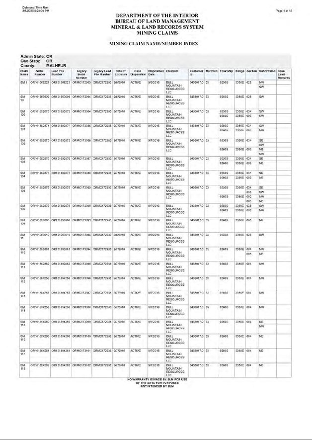
| NI 43-101 Technical Report Stockade Mountain Project | Page: 152 | |
| Malheur County, Oregon, USA | ||
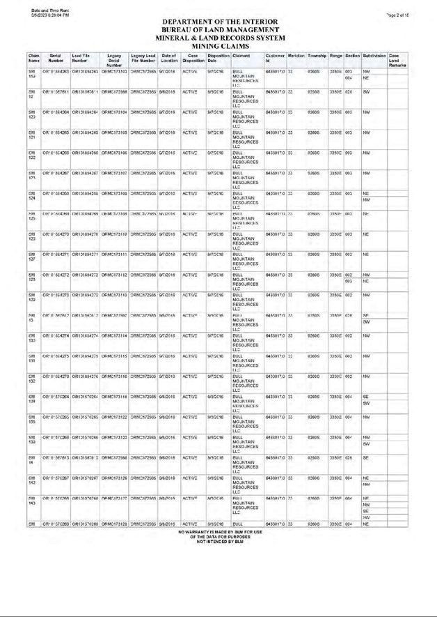
| NI 43-101 Technical Report Stockade Mountain Project | Page: 153 | |
| Malheur County, Oregon, USA | ||
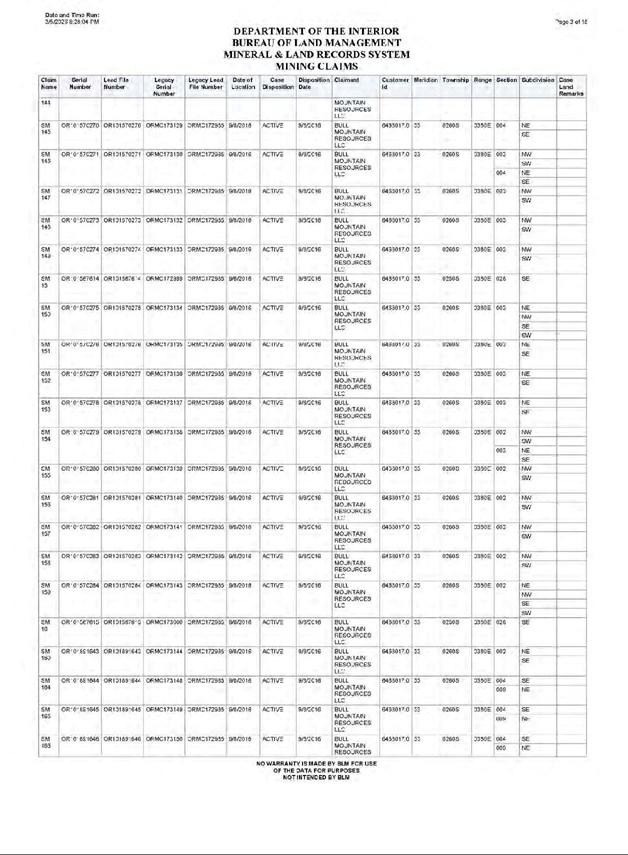
| NI 43-101 Technical Report Stockade Mountain Project | Page: 154 | |
| Malheur County, Oregon, USA | ||
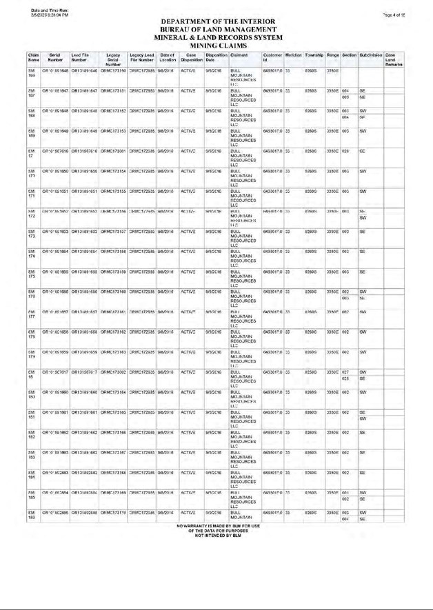
| NI 43-101 Technical Report Stockade Mountain Project | Page: 155 | |
| Malheur County, Oregon, USA | ||
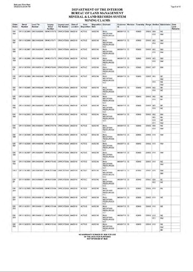
| NI 43-101 Technical Report Stockade Mountain Project | Page: 156 | |
| Malheur County, Oregon, USA | ||
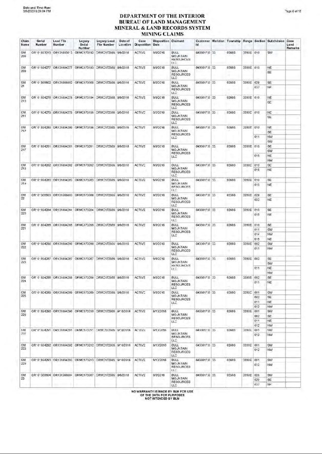
| NI 43-101 Technical Report Stockade Mountain Project | Page: 157 | |
| Malheur County, Oregon, USA | ||
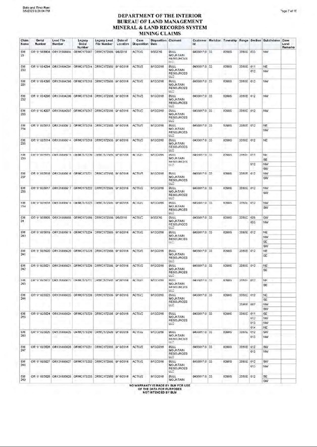
| NI 43-101 Technical Report Stockade Mountain Project | Page: 158 | |
| Malheur County, Oregon, USA | ||
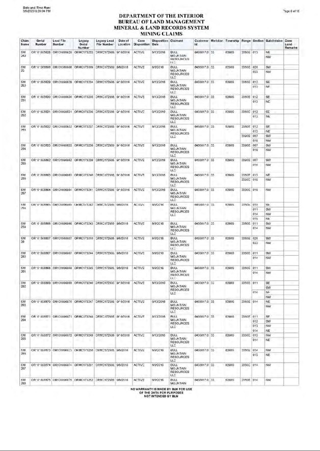
| NI 43-101 Technical Report Stockade Mountain Project | Page: 159 | |
| Malheur County, Oregon, USA | ||
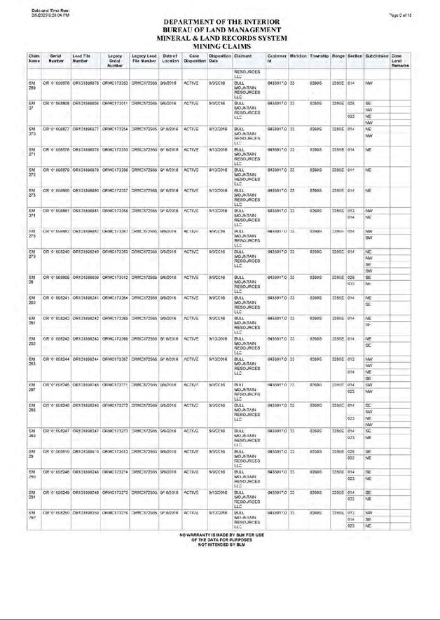
| NI 43-101 Technical Report Stockade Mountain Project | Page: 160 | |
| Malheur County, Oregon, USA | ||
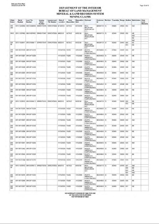
| NI 43-101 Technical Report Stockade Mountain Project | Page: 161 | |
| Malheur County, Oregon, USA | ||
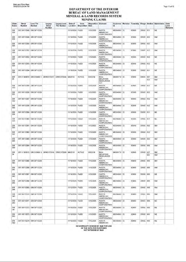
| NI 43-101 Technical Report Stockade Mountain Project | Page: 162 | |
| Malheur County, Oregon, USA | ||
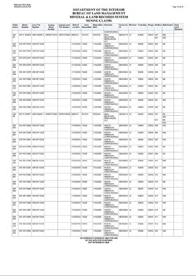
| NI 43-101 Technical Report Stockade Mountain Project | Page: 163 | |
| Malheur County, Oregon, USA | ||
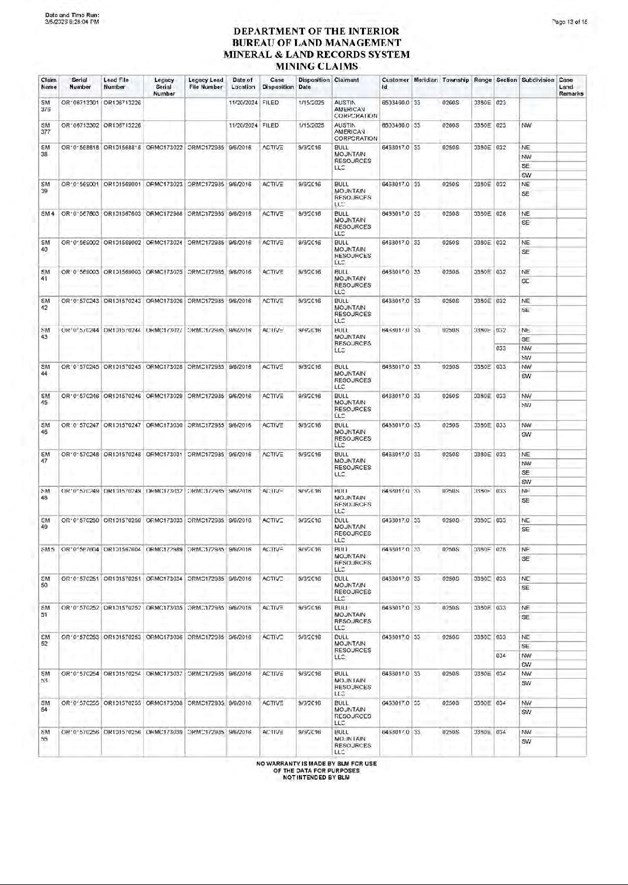
| NI 43-101 Technical Report Stockade Mountain Project | Page: 164 | |
| Malheur County, Oregon, USA | ||
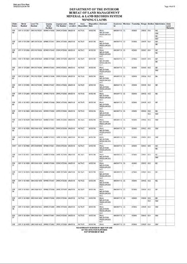
| NI 43-101 Technical Report Stockade Mountain Project | Page: 165 | |
| Malheur County, Oregon, USA | ||
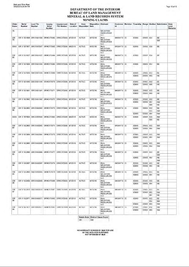
| NI 43-101 Technical Report Stockade Mountain Project | Page: 166 | |
| Malheur County, Oregon, USA | ||
| APPENDIX C - DRILLING COLLAR TABLE |
| NI 43-101 Technical Report Stockade Mountain Project | Page: 167 | |
| Malheur County, Oregon, USA | ||
Historical Drilling
| Hole_ID | Easting UTMNAD27 |
Northing UTMNAD27 |
Elev m |
Depth m |
Depth ft |
Azimuth | Dip | Drill type | Company |
| SCM-1 | 413245 | 4801012 | 1571.944 | 121.92 | 400 | 0 | -90 | Percussion | Carlin Gold |
| SCM-2 | 412563.5 | 4800438 | 1604.286 | 137.16 | 450 | 228 | -58 | Percussion | Carlin Gold |
| SCM-3 | 412617.3 | 4800495 | 1598.932 | 121.92 | 400 | 228 | -55 | Percussion | Carlin Gold |
| SCM-4 | 412661.7 | 4800551 | 1596.932 | 118.872 | 390 | 225 | -55 | Percussion | Carlin Gold |
| SCM-5 | 412717.8 | 4800605 | 1589.841 | 121.92 | 400 | 228 | -60 | Percussion | Carlin Gold |
| SCM-6 | 412775.1 | 4800650 | 1586.547 | 124.968 | 410 | 228 | -59 | Percussion | Carlin Gold |
| SCM-7 | 412644.6 | 4800529 | 1598.363 | 128.016 | 420 | 228 | -70 | Percussion | Carlin Gold |
| SM-1 | 416755.5 | 4797303 | 1549.241 | 134.112 | 440 | 218 | -70 | RC | BHP |
| SM-10 | 414631.6 | 4799905 | 1508.292 | 121.92 | 400 | 0 | -90 | RC | BHP |
| SM-11 | 416430.9 | 4797545 | 1582.39 | 76.2 | 250 | 0 | -90 | RC | BHP |
| SM-12 | 416331.8 | 4797544 | 1600.005 | 74.676 | 245 | 220 | -70 | RC | BHP |
| SM-13 | 416612.9 | 4797625 | 1536.459 | 91.44 | 300 | 0 | -90 | RC | BHP |
| SM-14 | 416839.7 | 4797628 | 1501.735 | 91.44 | 300 | 270 | -70 | RC | BHP |
| SM-15 | 416892 | 4797677 | 1498.661 | 91.44 | 300 | 0 | -90 | RC | BHP |
| SM-16 | 416776.6 | 4797804 | 1496.494 | 91.44 | 300 | 0 | -90 | RC | BHP |
| SM-17 | 416855.3 | 4797876 | 1484.347 | 97.536 | 320 | 220 | -70 | RC | BHP |
| SM-18 | 416954.5 | 4797764 | 1491.699 | 92.964 | 305 | 0 | -90 | RC | BHP |
| SM-2 | 416897.4 | 4797450 | 1534.342 | 123.444 | 405 | 220 | -70 | RC | BHP |
| SM-3 | 416970.1 | 4797521 | 1521.596 | 121.92 | 400 | 0 | -90 | RC | BHP |
| SM-4 | 417390.4 | 4797528 | 1478.903 | 121.92 | 400 | 0 | -90 | RC | BHP |
| SM-5 | 416378.6 | 4797600 | 1591.088 | 137.16 | 450 | 222 | -70 | RC | BHP |
| SM-6 | 416318.9 | 4797643 | 1581.956 | 152.4 | 500 | 221 | -70 | RC | BHP |
| SM-7 | 416883.8 | 4797601 | 1508.822 | 140.208 | 460 | 0 | -90 | RC | BHP |
| SM-8 | 416803.7 | 4797489 | 1532.268 | 115.824 | 380 | 220 | -70 | RC | BHP |
| SM-9 | 420378.3 | 4794720 | 1410 | 67.056 | 220 | 220 | -70 | RC | BHP |
| STK93-1 | 412836.6 | 4800404 | 1636.523 | 182.88 | 600 | 230 | -60 | RC | Placer Dome |
| STK93-10 | 414053.1 | 4799639 | 1637.898 | 118.872 | 390 | 180 | -45 | RC | Placer Dome |
| STK93-2 | 412851.3 | 4800257 | 1649.198 | 182.88 | 600 | 0 | -45 | RC | Placer Dome |
| STK93-3 | 414043 | 4799745 | 1609.034 | 143.256 | 470 | 90 | -60 | RC | Placer Dome |
| STK93-4 | 414043 | 4799745 | 1609.034 | 121.92 | 400 | 270 | -45 | RC | Placer Dome |
| STK93-5 | 414053.1 | 4799639 | 1637.898 | 74.676 | 245 | 90 | -60 | RC | Placer Dome |
| STK93-6 | 413956.9 | 4799613 | 1646.261 | 172.212 | 565 | 155 | -60 | RC | Placer Dome |
| STK93-7 | 413956.9 | 4799613 | 1646.261 | 79.248 | 260 | 0 | -50 | RC | Placer Dome |
| STK93-8 | 413861.9 | 4799632 | 1643.007 | 167.64 | 550 | 190 | -45 | RC | Placer Dome |
| STK93-9 | 413802 | 4799645 | 1650.035 | 76.2 | 250 | 255 | -45 | RC | Placer Dome |
| STKDH-1 | 413602.7 | 4799962 | 1589.734 | 120.396 | 395 | 270 | -70 | RC | Phelps Dodge |
| STKDH-10 | 414362.6 | 4799378 | 1583.244 | 137.16 | 450 | 270 | -50 | RC | Phelps Dodge |
| STKDH-11 | 414222.1 | 4799378 | 1621.949 | 86.868 | 285 | 90 | -75 | RC | Phelps Dodge |
| NI 43-101 Technical Report Stockade Mountain Project | Page: 168 | |
| Malheur County, Oregon, USA | ||
| Hole_ID | Easting UTMNAD27 |
Northing UTMNAD27 |
Elev m |
Depth m |
Depth ft |
Azimuth | Dip | Drill type | Company |
| STKDH-12 | 414175.5 | 4799458 | 1629.846 | 117.348 | 385 | 0 | -90 | RC | Phelps Dodge |
| STKDH-13 | 413094.6 | 4800365 | 1631.09 | 92.964 | 305 | 270 | -75 | RC | Phelps Dodge |
| STKDH-14 | 414158.5 | 4799378 | 1634.55 | 178.308 | 585 | 90 | -70 | RC | Phelps Dodge |
| STKDH-15 | 413853.1 | 4799567 | 1656.735 | 144.78 | 475 | 225 | -45 | RC | Phelps Dodge |
| STKDH-16 | 413950.3 | 4799515 | 1667.307 | 198.12 | 650 | 225 | -45 | RC | Phelps Dodge |
| STKDH-17 | 413747.1 | 4799450 | 1693.515 | 132.588 | 435 | 45 | -45 | RC | Phelps Dodge |
| STKDH-18 | 414087.1 | 4799518 | 1651.92 | 182.88 | 600 | 180 | -60 | RC | Phelps Dodge |
| STKDH-19 | 414241.1 | 4799517 | 1601.601 | 86.868 | 285 | 270 | -45 | RC | Phelps Dodge |
| STKDH-2 | 414097.2 | 4799123 | 1617.739 | 99.06 | 325 | 270 | -45 | RC | Phelps Dodge |
| STKDH-20 | 414241.1 | 4799517 | 1601.601 | 97.536 | 320 | 270 | -70 | RC | Phelps Dodge |
| STKDH-21 | 415046.8 | 4799391 | 1515.79 | 144.78 | 475 | 225 | -60 | RC | Phelps Dodge |
| STKDH-22 | 412708.1 | 4800307 | 1626.547 | 105.156 | 345 | 0 | -90 | RC | Phelps Dodge |
| STKDH-3 | 414039.6 | 4799498 | 1663.268 | 123.444 | 405 | 0 | -90 | RC | Phelps Dodge |
| STKDH-4 | 413908.4 | 4799485 | 1672.133 | 129.54 | 425 | 270 | -75 | RC | Phelps Dodge |
| STKDH-5 | 414004.4 | 4799360 | 1663.598 | 86.868 | 285 | 0 | -90 | RC | Phelps Dodge |
| STKDH-6 | 413794.7 | 4799955 | 1602.811 | 150.876 | 495 | 270 | -45 | RC | Phelps Dodge |
| STKDH-7 | 414038 | 4799318 | 1649.112 | 172.212 | 565 | 270 | -60 | RC | Phelps Dodge |
| STKDH-8 | 413960.6 | 4799486 | 1671.811 | 184.404 | 605 | 270 | -70 | RC | Phelps Dodge |
| STKDH-9 | 413908.4 | 4799485 | 1672.133 | 140.208 | 460 | 270 | -45 | RC | Phelps Dodge |
Current Drilling
| Hole_ID | Easting_NAD27 | Northing_NAD27 |
Elev_m | Depth_m | Depth_ft | Azimuth | Dip |
| SM-23-01 | 413900.3 | 4799500 | 1667.2 | 212.4 | 697 | 270 | -50 |
| SM-23-02 | 414000.3 | 4799495 | 1669.3 | 305.57 | 1002.2 | 270 | -55 |
| SM-24-04 | 414001 | 4799497 | 1669.3 | 224.55 | 736.7 | 0 | -72.5 |
| NI 43-101 Technical Report Stockade Mountain Project | Page: 169 | |
| Malheur County, Oregon, USA | ||
| APPENDIX D |
Assay Certificate for Independent Surface Sample Verification
| NI 43-101 Technical Report Stockade Mountain Project | Page: 170 | |
| Malheur County, Oregon, USA | ||
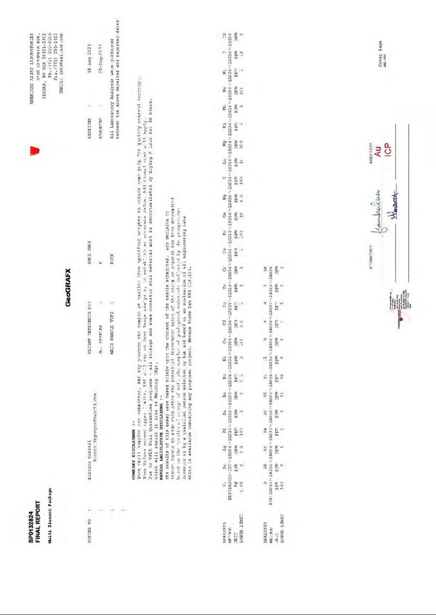
| NI 43-101 Technical Report Stockade Mountain Project | Page: 171 | |
| Malheur County, Oregon, USA | ||
| NI 43-101 Technical Report Stockade Mountain Project | Page: 172 | |
| Malheur County, Oregon, USA | ||
| NI 43-101 Technical Report Stockade Mountain Project | Page: 173 | |
| Malheur County, Oregon, USA | ||
| NI 43-101 Technical Report Stockade Mountain Project | Page: 174 | |
| Malheur County, Oregon, USA | ||
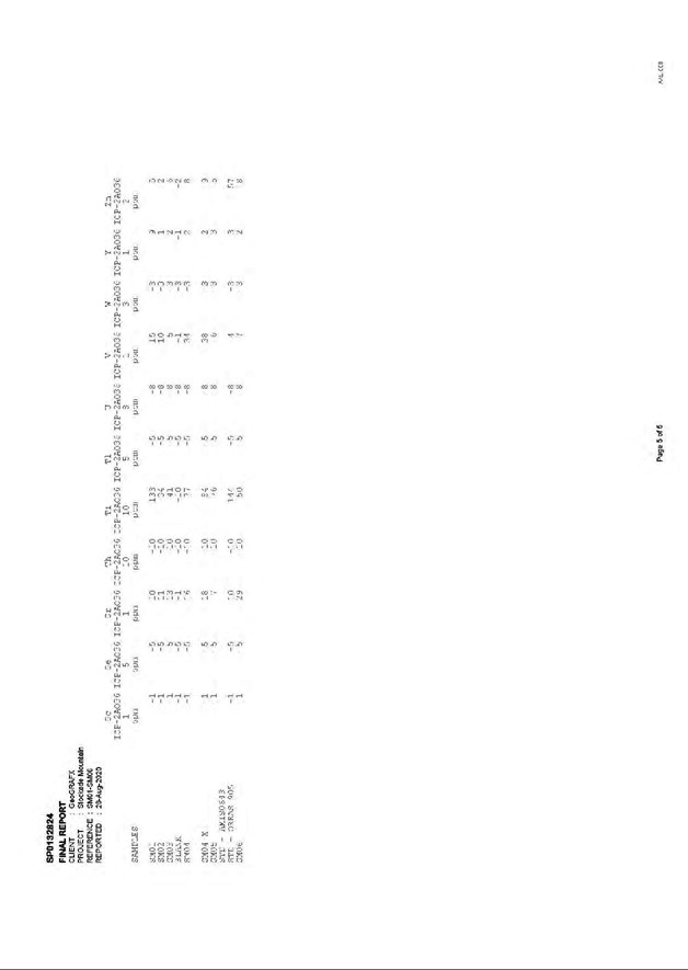
| NI 43-101 Technical Report Stockade Mountain Project | Page: 175 | |
| Malheur County, Oregon, USA | ||
| APPENDIX E |
Assay Certificate for Independent Pulp Sample Verification
| NI 43-101 Technical Report Stockade Mountain Project | Page: 176 | |
| Malheur County, Oregon, USA | ||
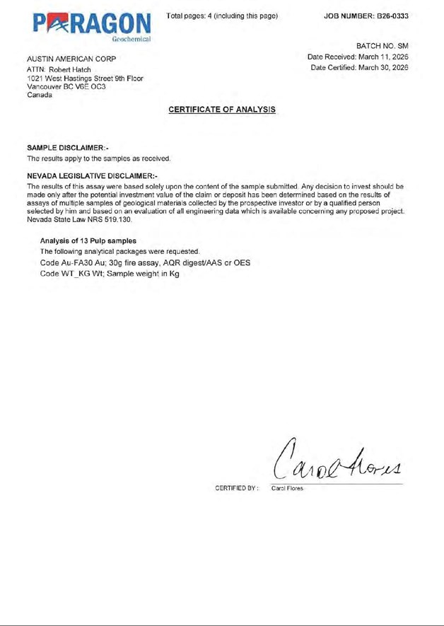
| NI 43-101 Technical Report Stockade Mountain Project | Page: 177 | |
| Malheur County, Oregon, USA | ||
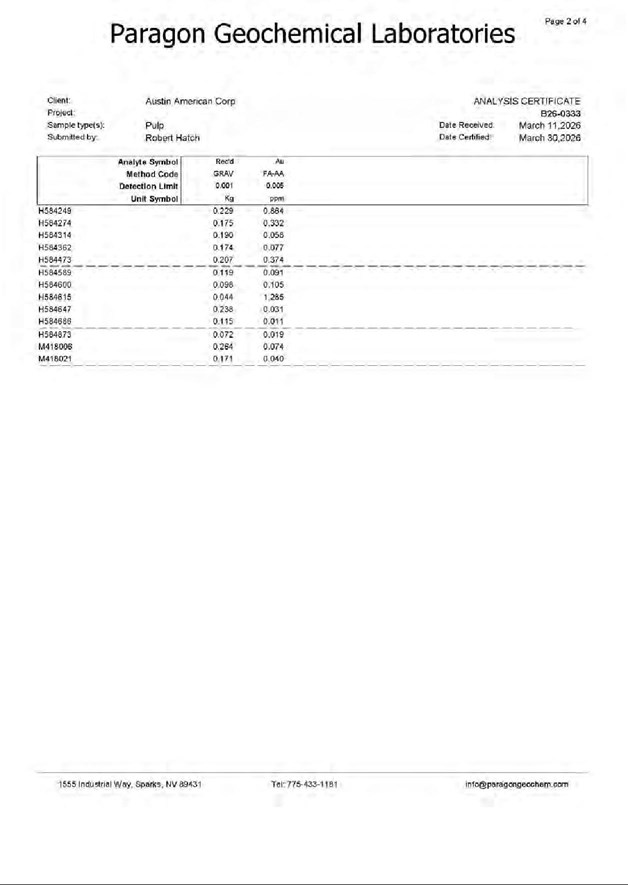
| NI 43-101 Technical Report Stockade Mountain Project | Page: 178 | |
| Malheur County, Oregon, USA | ||
| NI 43-101 Technical Report Stockade Mountain Project | Page: 179 | |
| Malheur County, Oregon, USA | ||