|
|
|

|
|
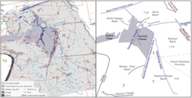
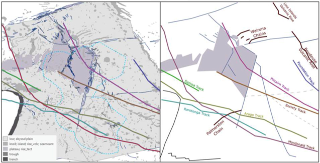
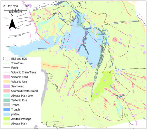
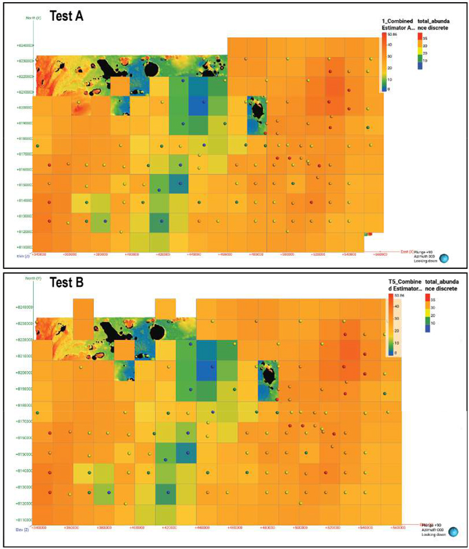
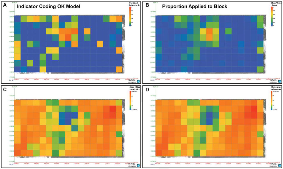
MINERAL RESOURCE ESTIMATE FOR THE EL3 COOK ISLANDS POLYMETALLIC NODULE DEPOSIT
MOANA MINERALS LTD |
Glasby, G. P., Stoffers, P., Grapes, R. H., Plüger, W. L., McKnight, D.
G. & DeL. Main, W., 1986. Manganese nodule occurrence in the Tasman Sea. New Zealand Journal of Marine and Freshwater Research, 20, 489–494.
Global Sea Mineral Resources, 2018. Environmental Impact Statement: Small-scale testing of nodule collector components on the
seafloor of the Clarion-Clipperton Fracture Zone and its environmental impact. DEME Group.
Gooday, A. J., Levin,
L. A., Linke, P. & Heeger, T., 1992. The Role of Benthic Foraminifera in Deep-Sea Food Webs and Carbon Cycling. in Rowe, G. T. & Pariente, V., eds., Deep-Sea Food Chains and the Global Carbon Cycle, Dordrecht, Springer
Netherlands, 63–91.
Guichard, F., Reyss, J.-L. & Yokoyama, Y., 1978. Growth rate of manganese nodule measured
with <SUP>10</SUP>Be and <SUP>26</SUP>Al. Nature, 272, 155–156.
Halbach, P.,
Scherhag, C., Hebisch, U. & Marchig, V., 1981. Geochemical and mineralogical control of different genetic types of deep-sea nodules from the Pacific Ocean. Mineralium Deposita, 16, 59–84.
Han, X., Jin, X., Yang, S., Fietzke, J. & Eisenhauer, A., 2003. Rhythmic growth of Pacific ferromanganese nodules and
their Milankovitch climatic origin. Earth and Planetary Science Letters, 211, 143–157.
Haugan, I.,
2015. We know more about the moon than the ocean floor.
Heath, G. R., 1979. Burial Rates, Growth Rates, and Size
Distributions of Deep-Sea Manganese Nodules. Science, 205, 903–904.
Hein, J. & Koschinsky, A.,
2014. Deep-ocean ferromanganese crusts and nodules. Geochemistry of Mineral Deposits:
Treatise of Geochemistry,
2nd Edition, 13, 273–291.
Hein, J. R., Koschinsky, A. & Kuhn, T., 2020. Deep-ocean polymetallic nodules
as a resource for critical materials. Nature Reviews Earth & Environment, 1, 158–169.
Hein, J. R. & Morgan, C. L., 1999. Influence of substrate rocks on Fe–Mn crust composition. Deep Sea Research
Part I: Oceanographic Research Papers, 46, 855-875.
Hoffert, M., 2008. Les Nodules
Polymétalliques dans les Grands Fonds Océaniques. Vuibert, Paris, Société Géologique de France, p. 432.
Hong, S., Kim, H.-W., Yeu, T.-K., Arai, R. & Yamazaki, T., 2021. Preliminary Economic Feasibility Study of Ferromanganese
Nodule Mining by Mechanical Lifting and Small-Scale Collectors. 11,
International Seabed Authority, 2013. 2013
ISBA/19/C/17. https://www.isa.org.jm/wp-content/uploads/2022/04/isba-19c- 17_0-2.pdf [accessed on 17/06/2024].
Jackson, M. G., Halldórsson, S. A., Price, A., Kurz, M. D., Konter, J. G., Koppers, A. A. P. & Day, J. M. D.,
2020. Contrasting Old and Young Volcanism from Aitutaki, Cook Islands: Implications for the Origins of the Cook–Austral Volcanic Chain. Journal of Petrology, 61, egaa037.
JICA-MMAJ, 2001. Report on the Cooperative Study Project on the Deepsea Mineral Resources in Selected Offshore Area on the
Sopac Region.
JICA, 1984. Republic of Zimbabwe Report on the cooperative mineral exploration of Shamva Area. Japan
International Cooporation Agency (JICA) Metal Mining Agency of Japan, Phase 1, 82.
Jones, D. O., Kaiser, S.,
Sweetman, A. K., Smith, C. R., Menot, L., Vink, A., Trueblood, D., Greinert, J., Billett, D. S. & Arbizu, P. M., 2017. Biological responses to disturbance from simulated deep-sea polymetallic nodule mining. PLoS One, 12, e0171750.
JORC Code, 2012. JORC, 2012, Australasian Code for Reporting of Exploration Results, Mineral Resources and Ore Reserves
(The JORC Code).
Kamenskaya, O. E., Gooday, A. J., Tendal, O. S. & Melnik, V. F., 2015. Xenophyophores (Protista,
Foraminifera) from the Clarion-Clipperton Fracture Zone with description of three new species. Marine Biodiversity, 45, 581–593.
Kennecott Corporation, 1965. Chemical composition of manganese nodules and a ferromanganese crust using different methods.
Kerr, R. A., 1984. Manganese Nodules Grow by Rain from Above: The rain of plant and animal remains falling into the deep
sea not only provides metals to nodules but also determines nodule growth rates and composition. Science, 223, 576–577.
Kojima, K., 1997. Review of Studies On Manganese Nodules Processing. Second ISOPE Ocean Mining Symposium,
ISOPE–M–97–004.
Kuhn, T. & Rühlemann, C., 2021. Exploration of Polymetallic Nodules and
Resource Assessment: A Case Study from the German Contract Area in the Clarion-Clipperton Zone of the Tropical Northeast Pacific. 11, Lee, G. C., Kim, J., Chi, S. B., Ko, Y. T. & Ham, D. J., 2008. Examination for correction factor for
manganese nodule abundance using the free fall grab and box corer. Journal of the Korean Society of Oceanography, 13, 280–285.
Page 142 of 154