|
|
|

|
|
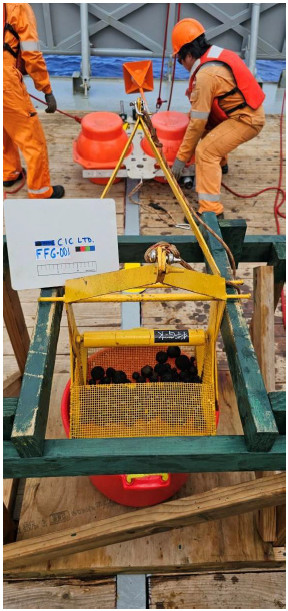
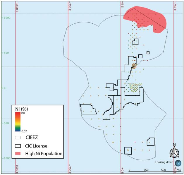
INITIAL ASSESSMENT FOR THE EL1
CIC LIMITED. |
Glasby, G. P., Stoffers, P., Grapes, R. H., Plüger, W. L., McKnight, D.
G. & DeL. Main, W., 1986. Manganese nodule occurrence in the Tasman Sea. New Zealand Journal of Marine and Freshwater Research, 20, 489–494.
Global Sea Mineral Resources, 2018. Environmental Impact Statement: Small-scale testing of nodule collector components on the
seafloor of the Clarion-Clipperton Fracture Zone and its environmental impact. DEME Group.
Guichard, F., Reyss, J.-L. & Yokoyama, Y., 1978. Growth rate of manganese nodule measured with <SUP>10</SUP>Be and <SUP>26</SUP>Al. Nature, 272, 155–156.
Halbach, P., Scherhag, C., Hebisch, U. & Marchig, V., 1981. Geochemical and mineralogical control of different genetic
types of deep-sea nodules from the Pacific Ocean. Mineralium Deposita, 16, 59–84.
Han, X., Jin, X., Yang, S., Fietzke, J. & Eisenhauer, A., 2003. Rhythmic growth of Pacific ferromanganese nodules and
their Milankovitch climatic origin. Earth and Planetary Science Letters, 211, 143–157.
Heath, G. R.,
1979. Burial Rates, Growth Rates, and Size Distributions of Deep-Sea Manganese Nodules. Science, 205, 903–904.
Hein, J. & Koschinsky, A., 2014. Deep-ocean ferromanganese crusts and nodules. Geochemistry of Mineral Deposits:
Treatise of Geochemistry, 2nd Edition, 13, 273–291.
Hein, J. R., Koschinsky, A. & Kuhn, T., 2020.
Deep-ocean polymetallic nodules as a resource for critical materials. Nature Reviews Earth & Environment, 1, 158–169.
Hein, J. R. & Morgan, C. L., 1999. Influence of substrate rocks on Fe–Mn crust composition. Deep Sea Research
Part I: Oceanographic Research Papers, 46, 855–875.
Heine, C., Yeo, L. G. & Müller, R. D.,
2015. Evaluating global paleoshoreline models for the Cretaceous and Cenozoic. Australian Journal of Earth Sciences, 62, 275–287.
Hoffert, M., 2008. Les Nodules Polymétalliques dans les Grands Fonds Océaniques. Vuibert, Paris,
Société Géologique de France, p. 432.
Hong, S., Kim, H.-W.,
Yeu, T.-K., Arai, R. & Yamazaki, T., 2021. Preliminary Economic Feasibility Study of Ferromanganese Nodule Mining by Mechanical Lifting and Small-Scale Collectors. 11,
Income Tax (Transfer Pricing) Regulations, 2014. https://parliamentci.wpenginepowered.com/wp-content/uploads/2022/07/Income-Tax-Transfer-Pricing-Regs-2014-No.-19.pdf.
Income Tax Act, 1997.
https://parliamentci.wpenginepowered.com/wp-content/uploads/2022/06/Income-Tax-Amendment-No.-5.pdf
.
Jackson, M. G., Halldórsson, S. A., Price, A., Kurz, M. D., Konter, J. G., Koppers, A. A. P. &
Day, J. M. D., 2020. Contrasting Old and Young Volcanism from Aitutaki, Cook Islands: Implications for the Origins of the Cook–Austral Volcanic Chain. Journal of Petrology, 61, egaa037.
JICA-MMAJ, 2001. Report on the Cooperative Study Project on the Deepsea Mineral Resources in Selected Offshore Area on the
Sopac Region.
JICA, 1984. Republic of Zimbabwe Report on the cooperative mineral exploration of Shamva Area. Japan
International Cooporation Agency (JICA) Metal Mining Agency of Japan, Phase 1, 82.
Jones, D. O., Kaiser, S.,
Sweetman, A. K., Smith, C. R., Menot, L., Vink, A., Trueblood, D., Greinert, J., Billett, D. S. & Arbizu, P. M., 2017. Biological responses to disturbance from simulated deep-sea polymetallic nodule
mining. PLoS One, 12, e0171750.
Kenex, 2014. Cook Islands Economic Exclusive Zone Prospectivity Study.
Kenex.
Kerr, R. A., 1984. Manganese Nodules Grow by Rain from Above: The rain of plant and animal remains falling
into the deep sea not only provides metals to nodules but also determines nodule growth rates and composition. Science, 223, 576–577.
Kuhn, T. & Rühlemann, C., 2021. Exploration of Polymetallic Nodules and Resource Assessment: A Case Study from the
German Contract Area in the Clarion-Clipperton Zone of the Tropical Northeast Pacific. 11,
Kuhn, T., Wegorzewski,
A., Rühlemann, C. & Vink, A., 2017. Composition, formation, and occurrence of polymetallic nodules. Deep-sea mining: Resource potential, technical and environmental considerations, 23-63.
Lipton, I., Nimmo, M. & Stevenson, I., 2021. NORI Area D Clarion Clipperton
Zone Mineral Resource Estimate - Update. AMC Consultants Pty Ltd.
Lipton, I. T., Nimmo, M. J. & Parianos, J.
M., 2016. NI 43-101 Technical Report TOML Clarion Clipperton Zone Project, Pacific Ocean. AMC Consultants Pty Lt, p. 280.
Lutz, M. J., Caldeira, K., Dunbar, R. B. & Behrenfeld, M. J., 2007. Seasonal rhythms of net primary production and
particulate organic carbon flux to depth describe the efficiency of biological pump in the global ocean. Journal of Geophysical Research: Oceans, 112.
Page 181 of 185