
Exhibit 99.1
INTERMAP TECHNOLOGIES CORPORATION
ANNUAL INFORMATION FORM
YEAR ENDED DECEMBER 31, 2025
Corporate Office
385 Inverness Pkwy
Suite 105
Englewood, Colorado 80112
U.S.A.
March 31, 2026
TABLE OF CONTENTS
| FORWARD-LOOKING STATEMENTS | 1 | |
| CORPORATE STRUCTURE | 2 | |
| GENERAL DEVELOPMENT OF THE BUSINESS | 3 | |
| DESCRIPTION OF THE BUSINESS | 8 | |
| General Overview | 8 | |
| Business Model and Revenue | 13 | |
| Revenues by Product Category | 14 | |
| Pricing | 14 | |
| Principal Markets | 14 | |
| Selling and Distribution Methods | 15 | |
| Production Process | 15 | |
| Competition | 17 | |
| Business Cycles | 19 | |
| Employees | 19 | |
| Foreign Operations | 19 | |
| RISK FACTORS | 19 | |
| DIVIDENDS | 25 | |
| DESCRIPTION OF CAPITAL STRUCTURE | 26 | |
| MARKET FOR SECURITIES | 26 | |
| Trading Price and Volume | 27 | |
| Prior Sales | 27 | |
| DIRECTORS AND EXECUTIVE OFFICERS | 29 | |
| LEGAL PROCEEDINGS AND REGULATORY ACTIONS | 30 | |
| INTEREST OF MANAGEMENT AND OTHERS IN MATERIAL TRANSACTIONS | 30 | |
| TRANSFER AGENT AND REGISTRAR | 31 | |
| MATERIAL CONTRACTS | 31 | |
| INTERESTS OF EXPERTS | 31 | |
| AUDIT COMMITTEE INFORMATION | 31 | |
| ADDITIONAL INFORMATION | 33 | |
| SCHEDULE A – Audit Committee Charter | A-1 |
Date of Information
This annual information form of Intermap Technologies® Corporation is dated March 31, 2026 (the “AIF”) and, unless the context otherwise requires, all references to the “Company” or “Intermap” means Intermap Technologies® Corporation and its subsidiaries. All information in this AIF is as of December 31, 2025, being the date of the Company’s most recently completed financial year, unless otherwise stated.
FORWARD-LOOKING statements
In the interest of providing the shareholders and potential investors of Intermap Technologies® Corporation with information about the Company and its subsidiaries, including management’s assessment of Intermap’s® and its subsidiaries’ future plans and operations, certain information provided in this AIF constitutes forward-looking statements or information (collectively, “forward-looking statements”). Forward-looking statements are typically identified by words such as “may”, “can”, “will”, “shall”, “should”, “could”, “anticipate,” “expect,” “project,” “estimate,” “forecast,” “plan,” “hope”, “likely”, “intend,” “target,” “believe,” and similar expressions suggesting future outcomes, and includes statements that actions, events, or conditions “may”, “would”, “could”, or “will” be taken or occur in the future. These forward-looking statements may be based on assumptions that the Company believes to be reasonable based on the information available on the date such statements are made, such statements are not guarantees of future performance and readers are cautioned against placing undue reliance on forward-looking statements. By their nature, these statements involve a variety of assumptions, known and unknown risks and uncertainties, and other factors which may cause actual results, levels of activity, and achievements to differ materially from those expressed or implied by such statements. The forward-looking information contained in this AIF is based on certain assumptions and analysis by management of the Company in light of its experience and perception of historical trends, current conditions and expected future development and other factors that it believes are appropriate.
The material factors and assumptions used to develop the forward-looking statements herein include, but are not limited to, the following: (i) there will be adequate liquidity available to the Company to carry out its operations; (ii) payments on material contracts will occur within a reasonable period of time after contract completion; (iii) the continued sales success of Intermap’s products and services; (iv) the continued success of business development activities and contract renewals; (v) there will be no significant delays in the development and commercialization of the Company’s products; (vi) the Company will continue to maintain sufficient and effective production and software development capabilities to compete on the attributes and cost of its products; (vii) there will be no significant reduction in the availability of qualified and cost-effective human resources; (viii) the continued existence and productivity of subsidiary operations; (ix) demand for geospatial related products and services will continue to grow in the foreseeable future; (x) there will be no significant barriers to the integration of the Company’s products and services into customers’ applications; (xi) the Company will be able to maintain compliance with applicable contractual and regulatory obligations and requirements, and (xii) superior technologies/products are not developed that would render the Company’s current product offerings inferior or obsolete.
| 1 |
Intermap’s forward-looking statements are subject to risks and uncertainties pertaining to, among other things, cash available to fund operations, availability of capital, revenue fluctuations, nature of government contracts, economic conditions, loss of key customers, retention and availability of executive talent, competing technologies, common share price volatility, loss of proprietary information, software functionality, internet and system infrastructure functionality, information technology security, breakdown of strategic alliances, international and political considerations, tariffs or other international trade disputes, environmental and social-related regulatory activity, the ability of our U.S. subsidiary to preserve and use U.S. net operating losses in the future as a result of ownership changes and artificial intelligence, including but not limited to those risks and uncertainties discussed under the heading “Risk Factors” in this AIF and the Company’s other filings with securities regulators. The impact of any one risk, uncertainty, or factor on a particular forward-looking statement is not determinable with certainty as these are interdependent, and the Company’s future course of action depends on Management’s assessment of all information available at the relevant time. Except to the extent required by law, the Company assumes no obligation to publicly update or revise any forward-looking statements made in this AIF, whether as a result of new information, future events, or otherwise. All subsequent forward-looking statements, whether written or oral, attributable to the Company or persons acting on the Company’s behalf, are expressly qualified in their entirety by these cautionary statements.
UNLESS OTHERWISE NOTED, ALL DOLLAR OR $ REFERENCES IN THIS AIF ARE EXPRESSED IN UNITED STATES DOLLARS.
CORPORATE STRUCTURE
Intermap Technologies Corporation (“Intermap” or the “Company”) was formed through the issuance of a Certificate of Amalgamation under the Business Corporations Act (Alberta) on February 25, 1997, as Intermap Technologies Limited. On November 11, 1996, the Company acquired all the assets that had comprised the image mapping services division of Intera Information Technologies Corporation (IITC), a company which traces its history operating mapping aircraft for the U.S. Army back to 1919. Many of the senior members of Intermap’s original management team were long-term employees of IITC, including the chief executive officer of IITC. The Company changed its name to Intermap Technologies Corporation and consolidated its Class A Common shares (the Shares or Common Shares) on a 12.5-to-one basis by Articles of Amendment filed on May 25, 1999. On December 1, 2017, the Company consolidated all of its outstanding Common Shares on a 10-to-one basis.
The head office of Intermap is located at 385 Inverness Parkway, Suite 105, Englewood, Colorado, USA 80112. Its registered office is located at 400, 3rd Avenue SW, Suite 3700, Calgary, Alberta, Canada T2P 4H2.
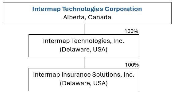
Intermap has two wholly-owned subsidiaries of material financial significance: Intermap Technologies, Inc. (Intermap U.S.A.), a corporation formed under the laws of Delaware, with its head office located in Englewood, Colorado and Intermap Insurance Solutions Inc., a corporation formed under the laws of Delaware and a wholly owned subsidiary of Intermap U.S.A.
| 2 |
Intermap U.S.A. satisfies a United States federal government requirement that a United States entity own certain of the technologies used by Intermap. Intermap Insurance Solutions Inc. provides software and services to the global insurance sector. The Company actively conducts business under its own name and through Intermap U.S.A. and Intermap Insurance Solutions Inc. The following chart illustrates the structure of the Company’s active subsidiaries and percentage of ownership.
GENERAL DEVELOPMENT OF THE BUSINESS
General History
Intermap was formed on January 31, 1996 and commenced active business operations on September 1, 1996. On November 11, 1996, the Company acquired all of the assets that had comprised the image mapping services division of Intera Information Technologies Corporation (IITC), a company which traces its history operating mapping aircraft for the U.S. Army back to 1919. On February 25, 1997, Intermap amalgamated with a junior capital pool corporation (effectively a publicly listed shell company) listed on the Alberta Stock Exchange (now the TSX Venture Exchange). On February 25, 2021, the Company’s common shares started trading on the OTCQX® Best Market in the United States.
The assets acquired from IITC included cash and cash equivalents, employees, contracts, software, equipment, and goodwill. On November 11, 1996, under a Transfer, Assignment, and License Agreement (the “ERIM Agreement”) among Intermap, Environmental Research Institute of Michigan (ERIM), and Intermap U.S.A., Intermap acquired the rights to certain International Traffic in Arms Regulations (ITAR) restricted digital mapping technology developed by the Defense Advanced Research Projects Agency (DARPA).
Today, Intermap generates revenue from two market segments, government and commercial, and three product categories: geospatial data collection, value-added data production and licensing, and related downstream software solutions and services. Intermap’s software solutions and services are unique because they bundle Intermap’s proprietary data collection, processing infrastructure, and archive library.
2022
In March 2022, the Company raised C$2.0 million through a private placement from treasury that included longstanding investors as well as new shareholders.
In October 2022, the Company announced the expansion of the Czech insurance business, with members of the Czech Association of Insurers committing to multiyear, multi-license contracts, with a total value of $3.1 million, for Intermap’s flood risk software, Aquarius RMA, and a new generation of precision flood hazard maps. The Czech Association of Insurers underwrite 98% of the total premiums in the Czech Republic. This multi-license contract with the major insurers in the market will provide critical access to flood hazard maps, high-resolution 3D data, and analytics across the industry. Intermap’s cloud-based software will be integrated seamlessly into the insurers’ workflows, streamlining analytics and geocoding capabilities and providing a comprehensive evaluation of flood risk that insurers will use to underwrite property.
| 3 |
During the fourth quarter of 2022, the Company raised C$1.7 million and issued 3.27 million warrants with an accelerated expiry whereby in the event that the closing price on the Toronto Stock Exchange is equal to or greater than C$1.00 for 20 consecutive trading days, the Company shall have the right to accelerate the expiry date of the warrants, which will raise an additional C$2.0 million upon exercise.
Also, during the fourth quarter of 2022, the Company was awarded two patents, expanding its portfolio of intellectual property and innovative AI/ML solutions. One patent covers machine learning techniques that automatically measure a building’s first floor height above ground level. This measurement improves the accuracy of Intermap’s flood risk assessment capabilities to grow its market share of the U.S. and European flood insurance markets. The technology uses machine learning to inspect building frontage imagery and detect the first floor based on building features, then algorithmically measures the distance to the ground. The first-floor height above ground is a key measurement when determining the flood risk of a specific property. Intermap’s flood risk assessment solution provides property-specific flood risk information, whereas other flood risk indicators are based on flood zones.
The second patent relates to producing bare-earth digital terrain models (DTM) under dense forest using airborne foliage penetrating P-band radar. This capability gives Intermap the unique capability to detect the ground through dense foliage and adjust the models of the ground below the canopy. Intermap is developing AI/ML-driven inputs to this patented process, such as automatic target detection, to enhance its terrain models. Accurate DTMs are critical for the creation of countrywide topographic basemaps used for policy formation, natural resource management, disaster management and land use planning. Ground detection through dense foliage cannot be achieved with LiDAR, IFSAR or optical photogrammetry techniques. Intermap’s patented radar and processing technology will be invaluable in supporting upcoming governmental mapping projects in tropical areas such as Southeast Asia.
Intermap continues to be the preferred provider for many governments that are building some of the world’s most complex geospatial foundation datasets. Intermap is currently building situational awareness for five national governments on four continents. Colombia’s federal mapping agency, IGAC, continues to contract with Intermap to build high-resolution, 3D models and analytics in mountainous jungle terrain obscured by nearly perpetual cloud cover in the Amazon Rainforest. Intermap is continuing to see double digit growth in InsitePro subscription revenue and customers are renewing each year with increased annual premium and usage. Intermap’s patented, low latency IRIS technology, combined with NEXTMap, is being utilized to turn space imagery into useful geospatial intelligence by enabling orbital space infrastructure, including for orthorectification and altimetry-based accuracy validation.
| 4 |
2023
In January 2023, Intermap was awarded its first task orders under the U.S. Defense Department’s JANUS contract and provided geospatial products processed using its advanced AI/ML technology to support the program’s mission to create and integrate geospatial intelligence for authoritative, seamless, worldwide datasets. The following month, Intermap was selected by the U.S. Department of Defense to present its newest artificial intelligence processing technology and demonstrate how it can support the U.S. government with actionable, geo-precise data for situational awareness and planning processes. The Company’s digital tool integrates AI algorithms, machine learning, natural language processing, proprietary, global-scale, multi-sensor-derived terrain, object and feature catalogs, and open-source global data to identify, track, display and notify interested parties of current world events, threats and natural catastrophes. Intermap also received its first task order from the Department of the Interior (DOI) under the Digital Terrain Model (DTM) Data IDIQ prime contract to support the agency’s Safety of Dams program. This was a major milestone for the Company’s relationship with the DOI for supporting its mission to protect human life and property in the event of a dam failure.
At the start of 2023, multiple InsitePro subscribers renewed their multiyear subscriptions with increases ranging from 60% to 350% as growth continued with increasing commercial awareness and adoption of elevation data and geospatial analytics as a service. In the first quarter of 2023, InsitePro monthly recurring revenue was up by more than 13% compared with the end of 2022. During the storm season, InsitePro empowered customers to report excellent underwriting results after Tropical Storm Hilary. Hilary dropped a year’s worth of rain on Southern California in three days, but InsitePro’s robust risk selection delivered low claims totals, with some large California underwriter customers reporting no claims at all. In November 2023, Intermap announced a new collaboration with its partner, Twinn by Royal HaskoningDHV, to offer the global insurance industry enhanced, comprehensive flood, natural hazard and climate change data. The collaboration augments both companies’ spatial intelligence capabilities and transforms risk assessment services, enabling insurers to make informed decisions, diversify portfolios and better manage natural hazard risks worldwide.
Intermap’s European insurance business also grew significantly with new multiyear subscription contracts in Slovakia with an aggregate value of $1.3 million. The Company also expanded into the European real estate market, offering its Aquarius RMA flood risk solution to real estate brokers for property valuation.
In July 2023, Intermap was contracted to provide its high-resolution NEXTMap elevation data and precision radar imagery to support the United States Geological Survey (USGS) and NASA’s Artemis III simulations and training exercises in the Arizona desert. Elevation data is critical for training missions on Earth to prepare for space missions, like Artemis III, and provides crucial data and insights for teams to conduct operations in a simulated lunar environment.
During the third and fourth quarters of 2023, Intermap closed various private placements of units (“Units” and individually, a “Unit”), with each Unit consisting of one Class A common share of the Company and one transferable common share purchase warrant at subscription prices ranging from C$0.50 to C$0.55 per Unit for aggregate gross proceeds of C$2,030,625.
In September 2023, the Company was contracted to supply its NEXTMap elevation data to a global spacecraft/launch/communications operator to be used for simulation, regulatory compliance and global situational awareness, including ground station RF interference modeling.
| 5 |
2024
In January 2024, Intermap was awarded a major contract to map the island of Sulawesi, representing 10% of Indonesia’s landmass under the national One Map program. This significant achievement demonstrates the Company’s ability to deliver high-resolution, cloud- and foliage-penetrating 3D data in dense tropical regions. Shortly thereafter, Intermap commenced work on the program, combining its unique airborne IFSAR technology with advanced AI/ML analytics to provide world-class geospatial capabilities.
By March 2024, Intermap had launched a new program in Malaysia to optimize water resources using AI/ML-driven data extraction, securing a $1 million award to enhance sustainable development. During this same period, the Company’s ongoing expansion into government infrastructure led to projects in Greece (focused on agriculture) and Malawi (for watershed management). Additionally, Intermap received its first payment from the Indonesian mapping contract, allowing full-scale deployment to proceed.
In April 2024, Intermap strengthened its position in Eastern Europe’s insurance sector by signing multiyear flood modeling subscriptions with major insurers in Slovakia. Early in the year, the Company’s global insurance business surpassed $1 million in total awards, reflecting increased commercial adoption of geospatial analytics. Intermap simultaneously renewed multiple InsitePro subscriptions, benefiting from broader commercial awareness of its precise elevation models and hazard data.
Throughout the summer, Intermap executed a series of private placements and public offerings, which concluded in August 2024 with over C$3 million raised to fund key initiatives, including the Sulawesi mapping program.
In August 2024, Intermap secured Phase Two of its prime contract with the U.S. Air Force to provide assured positioning, navigation, and timing solutions in GPS-denied environments. Later that month, the Company established a strategic partnership with Aon’s Impact Forecasting to enhance underwriting, risk management, and portfolio modeling for global insurers.
By September 2024, Intermap and its partner CACI were selected as a contracting team for the National Geospatial-Intelligence Agency’s Luno A program—worth up to $290 million over five years—emphasizing advanced commercial satellite imagery and AI-driven feature extraction. Vendors such as Intermap will compete on a full and open basis for delivery orders under this program.
During the third quarter of 2024, the Company issued 7,346,568 Units at a price of C$0.45 per Unit in connection with a private placement for aggregate gross proceeds of C$3.3 million.
In October 2024, Vienna Insurance Group’s Czech subsidiary adopted Intermap’s real estate valuation and flood risk solution, further underscoring the Company’s success in digitizing European underwriting and property analytics.
In November 2024, the Company announced third-quarter revenue growth of 241% year-over-year, largely fueled by its Indonesian data acquisition operations. Later that month, Intermap was awarded a subcontract for the U.S. Department of Defense supporting augmented reality solutions.
| 6 |
2025
In January 2025, Intermap expanded its U.S. national security footprint when the Company’s team (led by CACI) was selected by the National Geospatial-Intelligence Agency (NGA) as a vendor on the Luno B commercial GEOINT IDIQ contract, valued at up to $200 million over a five-year ordering period, with delivery orders competed among awardees.
In February 2025, Intermap closed a bought deal LIFE offering and concurrent private placement, raising approximately C$11.3 million (C$6.65 million from the LIFE offering and C$4.61 million from the concurrent private placement) to fund operations and government program execution. The financing helped support continued program scale-up and near-term working capital needs.
By March 2025, Intermap’s commercial insurance momentum continued to build, with year-to-date insurance awards surpassing $1.1 million. This included a new large multiyear subscription with a major European bank-insurance group and a partnership with PREMIUM Insurance adopting Aquarius RMA, underscoring growing demand for Intermap’s underwriting and risk analytics solutions.
In May 2025, Intermap reported strong Q1 performance with revenue rising to $4.3 million (from $1.7 million in Q1 2024) and a 28% pro-forma adjusted EBITDA margin.
In June 2025, Intermap announced a change in auditor, appointing MNP LLP with the objective of uplifting to PCAOB audit standards in preparation for US securities registration and NASDAQ up-listing.
In August 2025, Intermap reported Q2 results, generating $3.0 million in revenue and $2.1 million in operating cash flow. The Company also updated on Indonesia program activity and introduced early implementation of IRAS, its AI-driven insurance underwriting assistant.
In September 2025, Intermap broadened its financing flexibility by filing a final short-form base shelf prospectus enabling issuance of up to $100 million over approximately 25 months under a Canada/U.S. MJDS structure. During the same month, the Company announced a $20.1 million bought deal at $3.00 per share, then upsized the financing to $25.0 million gross due to demand, and later filed the related prospectus supplement.
In November 2025, Intermap reported continued commercial revenue growth for the third quarter, with the U.S. and Europe representing approximately 90% of revenue, and highlighted adoption of its AI Risk Assistant platform. The Company also noted $21 million gross financing, $26.9 million in shareholders’ equity as of the end of the third quarter, and ongoing government pursuits including Indonesia ILASP bids and NOAA team selections.
| 7 |
DESCRIPTION OF THE BUSINESS
General Overview
Intermap is focused on the creation, analysis, and provisioning of 3D terrain data and high-resolution thematic models of the Earth’s surface. The Company helps customers understand their terrain environment, as well as its natural and manmade features, to inform better decisions. Organizations that use its products include government planners, space and orbital sensor companies, GIS software users, regulatory agencies, insurance companies, military organizations, aviation authorities, commercial airlines, drone and helicopter companies, natural resource companies, telecommunications companies, environmental consultants, road transportation and logistics companies, land use planners, agricultural companies, consumer recreation apps, and navigation, simulation, and visualization companies.
Intermap deploys patented, dual-use sensors and processing technology that collect and fuse massive and disparate raw datasets into its commercial 3D geospatial library, called NEXTMap, the world’s largest. It then produces a suite of versatile, remotely sensed, 3D and multidimensional digital elevation models (DEM), precise, ground-true ortho-rectified images, map layers, thematic models, related digital infrastructure, software products, and solutions, all dynamically exploiting available sources, anytime, anywhere, at global scale - Your World. Made Simple.
Intermap’s sensor-agnostic, multiple-source approach, combined with proprietary, dual-use, company-owned military-grade sensors, which can be deployed as needed, patented processing engines and unique library, generate valuable, actionable geospatial intelligence. Its high-resolution, ground-true 3D data delivers decision advantage from a distance, with analytics available at speeds and scale, remotely through the cloud, that eliminate the need to deploy expensive, on-the-ground or in-field resources to answer geospatial questions and solve problems. This remote action is enabled by the dynamic geospatial intelligence Intermap provides.
Intermap’s customers can monitor and take remote action to optimize their land, air, space and sea assets; direct military mapping, surveillance, reconnaissance, and disaster response missions; monitor and analyze wetland, ice, vegetation, forest cover, including forest densities, harvest, soil erosion, depletion, regeneration, and flood zones; deploy highly reliable and precise operational navigation systems; conduct large scale transportation management, utility and land use planning, and remote insurance underwriting.
Over an extended period, Intermap invested several hundred million dollars to establish and productize its NEXTMap library of global 3D terrain data, much of it funded by meeting technology requirements for the U.S. government, including DARPA, the National Aeronautics and Space Administration (NASA), and the National Geospatial-Intelligence Agency (NGA). For its government customers, Intermap collects airborne IFSAR data, using a fleet of high-altitude jet aircraft equipped with dual-use and proprietary military-grade P-band SAR and X-band IFSAR sensors. From 2019-2025, Intermap invested more than $10 million to upgrade its proprietary sensor, platform and processing software. The Company has also patented a unique process to build highly accurate, 3D bare-earth DTMs, using proprietary radar that can penetrate to the ground through natural and manmade obstructions. In addition to 3D digital surface models (DSMs), Intermap provides extremely accurate DTMs over the same coverage areas. Intermap also invested more than $38 million from 2012 to 2016 to build leading-edge, 3D data exploitation and dissemination capability, using proprietary software, so products and solutions derived from its NEXTMap global library, augmented as required with new collections, are delivered with speed and scale, using intuitive, cloud-based software products and application programming interfaces accessible to non-expert geospatial users.
| 8 |
Intermap’s patented Intelligent Resolution Improvement System (IRIS) is a flexible and automated workflow technology that produces proprietary, source-agnostic, enhanced DEMs covering the entire land area of the Earth several times over, combining its NEXTMap library with new collections from its own sensors, as well as from other multi-source data, including remotely sensed 3D points from LiDAR, 2D EO/optical and SAR sensors from airborne and space platforms. By incorporating multi-source data, IRIS builds sensed 3D points capturing a broad electromagnetic spectrum of information and provides more precise and reliable 3D models than alternative approaches that use single source data, statistics, and interpolation to estimate reality. IRIS enables Intermap to maintain, refresh, enrich and operationalize NEXTMap so its installed solutions comprise the best 3D data available from multiple sources, efficiently tailored to meet requirements, while never becoming stale.
The Company’s policy is to retain intellectual property rights to its data. Intermap offers elevation data products as-a-service, software as-a-service and data through subscriptions and licenses. Its customers on every continent benefit from Intermap’s content and architecture to maximize their own geospatial investment. In this way, Intermap helps governments build their authoritative geospatial datasets to rigorous specifications in 3D, then leverages that highest quality data to solve problems for commercial customers. Intermap’s integrated collection, processing, exploitation, and delivery, allow clients to build and manage world-class foundation data, providing ground truth so subsequent data layers can work together. This is particularly important for military applications. Intermap has worked with more than 50 countries to build their geospatial infrastructure. Recent advances in computing power, sensor resolution and variety, machine learning technology, and data architectures have made the exploitation of integrated datasets more accessible and valuable than ever. Commercial clients benefit from Intermap’s ability to leverage its core NEXTMap global library and proprietary cloud infrastructure, and integrate geospatial intelligence seamlessly into their traditional workflows, without the need for expert users – providing better answers, greater profitability, faster delivery and improved safety and accuracy without exorbitant capital spending.
For many reasons, the geospatial industry is at an important inflection point, in government and commercial markets, where powerful 3D data is made available to non-expert users to inform decisions. For many important applications, 3D data works far better than traditional 2D data to provide answers to geospatial problems, particularly for problems requiring automated change detection. Because of its long history, Intermap is in a key position to facilitate and benefit from this trend, which is accelerating, by operationalizing global-scale 3D data. The Company has extensive experience and continues to invest in global-scale, high-precision, 3D, source-agnostic data creation and delivery. Since 2017, it has built the tools, library and technology, including AI workflows, to provision these assets with speed, in the cloud, and integrated into user workflows, all reliably sourced from Intermap’s trusted and proprietary global, 3D foundation layer at 1-meter or better DEM resolution, with congruent orthorectified imagery at better than 15cm resolution.
| 9 |
Intermap’s new applications are tailored to specific industries and even specific government agencies and companies, making the solutions cost effective and increasing customer reliance. Our innovative business model brings geospatial answers directly to imperative problems, offering data quality and speed as competitive advantages, and allowing our customers to acquire, repurpose, enrich and combine valuable geospatial data to answer questions and solve problems in ways that they can access from Intermap, without the need to duplicate complex infrastructure or sift through expensive data they do not need with uncertain quality and sourcing.
Intermap’s data margin is the difference between the cost of goods to develop new data products through NEXTMap and proprietary collection or acquisition (build) and the ability to monetize those data products as licenses, software or solution sales (deploy). Combined with advances in sensors and computing power, Intermap’s legacy capital investment in technology, data, sensors, systems architecture and platform allows us to monetize our products with extremely high data margin. The Company’s growing NEXTMap geospatial library powers AI-driven algorithms, making each new solution faster, cheaper to build, richer in content and more relevant. Intermap’s proprietary data library, unique sensors, patented technology, low latency process to invest, create, and maintain new data, and related application tools, collectively provide the Company with tremendous operating leverage and competitive advantages, driving product margins, volume, automation, and repeatability without incurring significant additional costs. This is the value of owning and maintaining a highly precise global digital elevation model and library and a fully vertically integrated sensor-to-user process.
For example, Intermap’s elevation data as-a-service and elevation analysis as-a-service, which deliver x, y and z coordinates, are growing +30%, driven by non-expert geospatial users in the insurance, telecommunications, and aviation industries. Similar trends are taking shape in government and military markets, to reduce latency, improve accuracy, and build scale, as decision makers push 3D geospatial capability to their non-expert geospatial users “at the edge.”
Summary of Products and Services
Data Acquisition and Production
Historically, this has been the Company’s core source of revenue. Work is project-based, typically with sovereign clients, and each project is tailored to the specific needs of the client. Intermap’s aircraft can operate around the world, and with the support of local partnerships, the Company has never failed to deliver on a data acquisition project. The digital elevation models created from this radar sensor have up to a 0.5-meter posting and vertical accuracy of up to 1-meter (LE90) in unobstructed regions with slopes less than 10 degrees. The image created from the radar sensor has been corrected to remove geometric distortions caused by the terrain and has up to a 0.25-meter resolution and horizontal accuracy 1.5-meter (CE90).
Value-added Data Licenses
Intermap’s radar sensor systems create three core digital map products as follows:
Digital Surface Model (DSM): a digital elevation model that measures the top surface of the earth and objects located on it. The DSM is derived from the radar hitting the top of objects or the “first-reflective-surface.” The DSM data includes vegetation, buildings, roads, and natural terrain features. Examples of DSM-related applications include line-of-sight calculations for cell tower placement, property development analysis, and military operations support. A DSM can also be used as a comparatively inexpensive means to improve the accuracy of cartographic products such as topographic line maps and road maps.
| 10 |
Digital Terrain Model (DTM): a topographic model of the “bare earth.” A DTM is a DSM that has had vegetation, buildings, and other cultural features digitally removed, leaving just the underlying terrain. This is achieved using Intermap’s proprietary software tools that create terrain elevations based on measurements of the ground contained in the original radar data. A DTM provides a geometrically correct reference frame over which other data layers, such as aerial photography and other types of images, can be draped. The DTM, coupled with surface analysis tools, supports applications such as the development of accurate topographic maps. The DTM is also a valuable component in analysis involving various terrain characteristics such as profile, cross-section, line-of-sight, aspect, and slope. Examples of DTM-related applications include flood modeling, agricultural land analysis, recreational GPS applications, internet mapping, optical image orthorectification and automotive applications. Having this layer also improves the accuracy of the feature layers, including land cover and land use layers, that are concurrently extracted to create the DTM.
Multi-Frequency Orthorectified Radar Imagery (ORI): The system produces 5 image layers: four P-band polarimetric images (including HH, HV, VH, and VV) which provide information on infrastructure, including infrastructure under vegetative cover and one X-band image (HH polarization). All 5 radar images are grayscale, look similar to a black-and-white photograph, and image the earth’s surface. The ORIs are derived from the intensity of the radar wave that is rebounded from the earth’s surface back to the radar system, either X or P. The radar imagery is then processed using the DSM to remove the distortions that are inherent with any image collection process. This rectification process results in each pixel in the image being located in its correct geometric position. The ORI is typically used as the basis for extracting terrain features such as roads, trees, and buildings and for other mapping applications such as topographic line maps.
Intermap’s production and editing capabilities create the following digital products in areas the radar sensor has not collected data:
NEXTMap One: Precision, 3D geospatial data at an unprecedented 1-meter resolution, produced using Intermap’s patented Intelligent Resolution Improvement System (IRIS). By combining the best features from multiple sensors, IRIS generates a seamless global dataset that is both highly accurate and spatially rich. Intermap uses high-resolution satellite imagery along with multi-band radar, LiDAR and other datasets to produce NEXTMap One. This blend of data produces a very high vertical accuracy of up to 1-meter (LE90), enabling new applications at an affordable price. NEXTMap One is designed for continual and real-time updates, with planned yearly data updates.
Using the above core products as foundation elements, Intermap produces additional mapping and image products for its customers tailored to customer-specific accuracy requirements, file formats, and coordinate systems. These products include:
Custom contours: enable the end user to perform profile analyses, elevation identification, slope modeling, or to create detailed maps. Because these contours are based on the Company’s geospatial database DTM, the Company is able to offer higher accuracy digital map products than traditional publicly available products.
Terrain-derived hydrology datasets: provide water bodies and double line drainages. With this dataset, the end user can perform more accurate stream flow and soil erosion analyses, and snowmelt runoff predictions.
Terrain-derived coastline datasets: represent coastal boundaries in the end users’ areas of interest. The end user can use it in coastal GIS applications for more efficient and correct analyses.
Slope maps: represent the terrain’s degree of slope. This is useful for quick and effective slope analyses of the terrain.
| 11 |
Aspect maps: display the cardinal direction of the slope for effective terrain analyses. The aspect helps define the amount of
sunlight striking the surface of the terrain.
Hillshade image: provide the end user with a more accurate and clearer visualization of the topography. It is well suited for hiking applications, site planning, presentations, and plotting.
Contours: provide high quality contour layers as a visual aid to performing profile analysis, elevation identification, slope indication, or to create detailed maps.
Clutter: includes both Clutter Type and Clutter Height provided for all vegetation and urban clutter classes.
Land cover: provides a colorized land classification overlay that identifies and classifies the context of the urban footprint, open land, and forest cover.
Intermap’s data is licensed to clients for tightly defined end uses, or to value-added resellers to create and commercialize derivative products.
Data as-a-Service Solutions
InsitePro: InsitePro is configurable insurance underwriting software. The application calculates location-specific risk by combining the Company’s geospatial datasets with third-party and public information to create accurate and dependable risk assessments for natural catastrophe risk. InsitePro delivers risk information derived from complex risk models and datasets in a clear visual environment, in terms that fit seamlessly with a client’s business and workflow. Clients can evaluate single locations or large portfolios of locations quickly and easily. InsitePro is gaining market share in the United States insurance market with underwriters and carriers who are insuring flood. With changes to the National Flood Insurance Program, it is expected that demand for risk assessment solutions that can support flood underwriting will increase significantly. Beyond the United States, InsitePro is also gaining market share in Canada.
InsitePro is sold directly to clients as pre-paid annual subscriptions.
Aquarius Software and Solutions: In 2021 Intermap transitioned most of its European product suite onto cloud infrastructure, enabling multi-user licensing of country-specific solutions. With this new delivery infrastructure, the Company has been able to expand into new countries in the region.
Insurance software and solutions are sold directly to clients with the majority of revenue now based on pre-paid subscriptions.
NEXTView®: The Company’s high-quality configurable data solution serves various aviation markets, including avionics, drone and government regulatory agencies. The solution combines information and data from both Intermap and Lufthansa Systems to deliver superior terrain and obstacle awareness that improves airborne safety and efficiency. The partnership with Lufthansa Systems enabled the solution to be certified for avionic applications. This certification is a significant barrier to entry into the aviation market. Lufthansa currently serves a large market share of avionics manufacturers and airlines through which it offers NEXTView.
| 12 |
Business Model and Revenue
Intermap’s foundational assets and core capabilities provide a competitive advantage. Any future competitors hoping to offer geospatial solutions on the same scale as Intermap will be faced with prohibitive capital costs and will be competing for customers who are able to purchase products and services with immediate availability from Intermap. Additionally, competitors’ software or AI products will not have access to Intermap’s proprietary geospatial archive.
Intermap operates in one industry segment, digital mapping and related services, with three different classifications of revenue: Acquisition Services (fee-for-service contracts), Value-added Data Licenses (geospatial database licensing), and Software and Solutions.
Geospatial Data Acquisition and Production Services
The Company’s mapping services business typically involves a client requesting imagery and/or a digital elevation model for a specific area and purpose. Intermap provides such data on a fee-for-service contract basis and then typically licenses the use of the data and/or digital maps to the customer. These custom mapping services projects have traditionally been conducted as a result of government or commercial contracts. The offerings frequently include data integration and maintenance programs. Project-specific contractual data acquisition has historically generated significant revenues and margins for the Company. However, they are unpredictable in timing and value, thus creating sources of revenue and margins that can vary significantly on a quarter-to-quarter and year-over-year basis. The Company is mitigating this risk by increasingly including as-a-service and on-premise proprietary software application layers that allow customers to rapidly maintain and update their data products. See “Risk Factors – Revenue Fluctuations.”
Value-added Data Licenses
Intermap creates and updates a worldwide database of location-based information which is licensed to a broad group of customers. Intermap adds value to raw data to maximize the revenue and usefulness for the client. The products are provisioned as a service or through on-premise license.
Software and Solutions
Intermap’s software is licensed with pre-paid annual subscriptions which generate recurring predictable revenue. Services are delivered on a contract-by-contract basis.
NEXTView is licensed for drone applications through annual subscriptions based upon the nature of the business and number of drones. Government aviation authorities purchase long-term licenses, with maintenance and updates sold in subsequent years.
| 13 |
Revenues by Product Category
The Company recorded revenues for the following categories of products and services during the two most recently completed financial years:
| (in thousands) | 2025 | 2024 | ||||||
| Acquisition Services | $ | 3,949 | $ | 10,496 | ||||
| Value-added Data | 1,408 | 3,110 | ||||||
| Software and Solutions | 5,213 | 4,031 | ||||||
| $ | 10,570 | $ | 17,637 | |||||
The decline in Value-added Data and Acquisition Services related to government contracting delays in funded programs.
Pricing
Pricing for mapping services varies by customer, location, and their individual requirements. The project price under a contract is typically negotiated with the customer as a function of the area requested, its location, terrain characteristics, and the type of license requested.
The Company’s value-added data pricing is dependent on accuracy and includes set pricing per square kilometer or data usage level, if it is acquired as a service.
The Company’s software and solutions pricing includes annual subscriptions, data usage charges, and one-time purchases of enterprise level licenses, per-user, per-click and for specific functionality.
Principal Markets
Market Overview
Intermap believes that several markets requiring reliable location-based information and 3D terrain data exist as follows:
Government Agencies
A large portion of Intermap’s revenue comes from government contracts with national mapping agencies. The Company is a leading supplier of imagery, DSMs and DTMs to United States federal agencies, including the NGA and the USGS. As the Company collects data around the world, it expects increased opportunities to arise for selling licensed products to government agencies outside of the United States.
Data is a key requirement for many types of initiatives, including base mapping/cadastral systems, infrastructure planning, natural resource management, land use, risk management, economic development, navigation, telecommunications, military applications and intelligence.
Geospatial Data Market
Beyond government agencies, end users of geospatial data are found throughout the economy, including banks and financial institutions, automakers, telecommunications companies, software providers, engineering firms, real estate analytics companies, and more.
Intermap is continuing to develop its insurance software applications, InsitePro and Aquarius, to continue to gain market share in the U.S. and European markets. Underwriters and carriers concerned with flood and other natural catastrophe perils are increasingly demanding solutions that can help assess, segment, rate and select risks for underwriting. The multi-perils insurance industry is evolving quickly in the United States, Canada, Europe and Asia, and Intermap is poised to serve those growing markets.
Intermap is marketing its geospatial database to a number of traditional geospatial markets. In these markets, customers typically use desktop-based GIS and engineering systems offered by strategic companies such as ESRI (a GIS mapping software company), Autodesk (a 3D design software company), and Blue Marble - Global Mapper (a GIS data processing company) for planning, engineering, environmental management, site, or route selection and permitting.
| 14 |
Selling and Distribution Methods
Data distribution occurs through direct sales, channel partners, value-added partners, OEMs, or through the Company’s Internet-based store.
Direct Sales
Direct sales are carried out through a commissioned sales team employed by the Company. The direct sales team is responsible for the sale of data acquisition services, licensing of the geospatial database, and software subscriptions.
Channel Partners
In order to reach markets not easily accessed by traditional direct selling efforts, the Company leverages a network of channel partners. These partnerships are established to broaden the Company’s customer base, penetrate new markets, and establish recurring revenue streams. The Company attempts to work with channel partners who are generally well-positioned in broad and diverse vertical markets. The channel partners distribute the Company’s products and services to their principal markets and create and sell solutions or consumer products based on the Company’s product infrastructure.
Production Process
The Company owns all of the technology required to create, collect, process, edit, and deliver products to its customers. All of the Company’s production processes, quality assurance, and quality control processes are documented under the Company’s ISO 9001:2000 Quality Management System.
Radar Production
Areas targeted for radar collection are first flight-planned by Intermap’s operations staff. Field crews are then dispatched to install GPS-based ground control points, as required. The aircraft and radar are subsequently flown to collect data over the target locations. The collected raw radar data is sent to the Company’s interferometric processing (IP) centers either in Denver, Colorado; Calgary, Alberta; or Jakarta, Indonesia. The DSM and ORI are fed into Intermap’s auto DTM engine. This engine creates a digital terrain model completely automatically which enables Intermap to scale up the production of our core products. Once the DSM, DTM, and ORI are generated, they are passed to quality assurance for checking where quality is ensured.
| 15 |
Specialized Skill and Knowledge
The Company needs well-trained technical staff having knowledge in science, engineering, software development and radar-related disciplines and/or mapping. Many of its senior engineers are published leaders in their field with advanced degrees. Intermap fills a portion of its requirements for software developers, engineers, scientists, and technicians through recruitment programs at accredited colleges and universities. Career paths frequently lead from technician to design engineer or software developer, to manager. In addition, the requirement for mapping specialists is fulfilled from the conventional GIS community or through graduates of GIS programs at both community colleges and universities.
Radar Technology
The Company’s ability to produce multi-frequency radar imagery and 3D digital elevation models over large areas and with a high level of detail and accuracy results from its proprietary radar digital mapping technology. This technology remotely and simultaneously collects latitude, longitude, and elevation (x, y, and z coordinates) data with an extremely high level of efficiency relative to other mapping technologies. An added benefit of radar technology is the ability to collect data in poor visibility conditions (night or cloud cover) and to fly at high altitudes, which facilitates a wide swath of data collection. The Company’s standard DEM product provides a vertical accuracy of 0.5-meter resolution (LE90) in unobstructed regions with slopes less than 10 degrees and imagery of a horizontal resolution of up to 0.25-meters. The P-band sensor provides the unique capability of foliage penetration, providing imagery of infrastructure typically hidden below forest canopy at resolutions of up to 0.25-meters. Intermap believes it has a strong leadership position in the mapping industry as a result of its proprietary IFSAR radar technology.
The Company operates two radar systems. Each system consists of two quad-polarimetric P-band antennae, two X-band radar antennae coupled to a transmitter receiver and data storage system. Both radar systems are mounted in Learjet 36A aircraft.
Compared with competing technologies, the Company’s ability to produce data on time and within a specified budget is largely due to the radar technology’s all-weather acquisition capability (with the exception of abnormally high winds and turbulence) and its superior speed and efficiency. The post-collection processing of the data is also much faster and less labor-intensive than competing technologies (see “Competition).
| 16 |
Competition
Data Acquisition
The Company’s geospatial solutions approach includes the use of an airborne remote sensing radar technology and there are a number of such technologies that compete with Intermap’s radar-based capabilities as summarized below:
LiDAR: Intermap believes that LiDAR is the most competitive technology to the Company’s IFSAR based radar system because of its availability and accuracy. The equipment is easily obtainable, and mapping services are usually offered by companies on a fee-for-service basis. Pricing, while project-specific, typically ranges from approximately $100 to $250 per square kilometer in the U.S. for large areas (>5000 kilometers square), roughly five to ten times the cost of Intermap’s products and the end product varies dramatically in quality and precision. In other parts of the world, the price can be significantly higher. However, given the high level of competition in the LiDAR sector, it is likely that prices will continue to be driven down. Although LiDAR is capable of higher accuracy than Intermap’s radar technology when collected at low altitudes, it continues to have challenges in our markets due to its inability to cover large areas efficiently, limited ability to fly in poor weather conditions, non-standard processing methods to derive hydro-enforced (rivers run downstream) DSM and DTM finished data products, and a much higher cost associated with collecting large areas relative to the Company’s radar technology. Furthermore, Intermap believes that LiDAR does not play a key role in the cloud belt regions of the world, due to its inability to operate through dense clouds. While Intermap considers its radar capability to be a competing technology, the Company also has partnership agreements with LiDAR suppliers to provide their products and services as part of an optimum geospatial solution for the Company’s customers and has processed and integrated LiDAR collections for many of its customers.
Other IFSAR Systems: The Company is currently unaware of any other commercially operational airborne IFSAR systems. Historic competitors such as Orbisat da Amazonia S.A. (Orbisat) and Fugro do not appear to have active airborne IFSAR capability at the present time.
Satellite Imagery: High-resolution commercial satellite technologies, with the capability to derive high resolution elevation models, have entered the market. Intermap partners with certain satellite imagery suppliers to provide dedicated geospatial solutions to its customers.
Optical and SAR Satellite Sensors: For technical and economic reasons, Intermap believes it is difficult to use satellite optical data from suppliers such as Maxar, Capella, Iceye, MDA and Planet to generate stereo images of large areas and apply photogrammetry or INSAR to create useful elevation data. Intermap has previously sold terrain data to satellite companies in order to provide them with the elevation data they require to rectify their satellite imagery for their customers. Intermap also sells terrain data to NGA, which is the largest customer for the satellite companies. The Company regards satellite imagery as a complementary 2D data layer, providing color or black-and-white optical images that can be draped over Intermap’s 3D terrain data.
With the recent advancements in Intermap’s Web Service offerings, based on the NEXTMap database, there are newfound possibilities in the orthorectification of satellite images. Intermap is now finding several high-resolution satellite providers are inquiring about services based on our NEXTMap database. These include both online and under license services.
The Ministry of Economy, Trade, and Industry (METI) of Japan and the United States National Aeronautics and Space Administration (NASA) released the ASTER GDEM V2 on October 17, 2011. This elevation model has a vertical accuracy of 20-meters compared to Intermap’s 0.5-meters. The first version of the ASTER GDEM, released in June 2009, was generated using stereo-pair imagery collected by the ASTER instrument onboard the satellite. ASTER GDEM coverage spans from 83 degrees north latitude to 83 degrees south, encompassing 99 percent of Earth’s landmass. The improved GDEM V2 adds 260,000 additional stereo-pairs, improving coverage and reducing the occurrence of artifacts. The refined production algorithm provides improved spatial resolution, increased horizontal and vertical accuracy, and superior water body coverage and detection. The ASTER GDEM V2 maintains the GeoTIFF format and the same gridding and tile structure as V1, with 30-meter postings and 1 x 1 degree tiles. This elevation data set has not been hydro-enforced and is negatively biased downward by approximately 10-meters. Intermap believes that this data is not sufficiently precise for most commercial applications such as aviation safety, environmental control, engineering, flood management and topographic mapping.
| 17 |
Small SAR Satellite Sensors: A number of startups including Capella Space, Iceye, and Planet, have launched or are preparing to launch SAR smallsats. SAR satellites can gather data day and night, and through all weather conditions, but they do not possess the technology to produce high quality DEMs, nor is it their focus.
SAR Satellite Sensors: Starting with the launch of TerraSAR-X in 2010 by the German military, there are now a number of X-band SAR synthetic aperture radar (SAR) satellite systems that provide commercially available 2D data of varying resolutions depending on whether collection occurs in strip map (typically 3-meter resolution) or spotlight mode (up to 0.5-meter resolution). Nearly all the satellite SAR systems offer image-only products, with one exception: in 2007, a second TerraSAR-X satellite platform was launched in a tandem orbit with the origin creating the Tandem-X mission. This provides an interferometric solution to derive digital elevation data, which is available to the public as a 12-meter posting, 3-meter vertical accuracy elevation model, compared to 0.5-meter posting provided by Intermap.
One-Time Shuttle Mission: A NASA space shuttle mission flown in February 2000 generated near worldwide digital map coverage of the Earth’s surface, using IFSAR technology. Intermap was chosen by NGA to produce and edit the shuttle mission data. The digital maps generated by Intermap have a vertical accuracy of 10-meters at 30-meters horizontal resolution (USA), or DEM posting. Intermap believes that this data is not sufficiently precise for most commercial applications such as automobile related applications, aviation safety, environmental control, engineering, and flood management.
While Intermap expects competitors to eventually develop or acquire technology that competes with its IFSAR radar digital mapping capabilities, the Company believes that it has a lead in accuracy, efficiency, production throughput, know-how, and software tools to manage the production process. In particular, within the cloud belt, the high resolution (.25-meter) cloud free Multi-Frequency IFSAR radar image is still a key differentiator for Intermap. The Company’s business initiatives, InsitePro, 1-meter elevation data, World 30 DSM, and World 10 DSM, along with its e-commerce data store are intended to capitalize on the market lead Intermap believes it currently enjoys. Additionally, while Intermap considers satellite imagery to be a competing technology, the Company also has partnership agreements with certain satellite imagery suppliers to provide their products as part of an optimum geospatial solution for the Company’s customers.
| 18 |
Software and Solutions
Intermap’s Insurance offerings, including software and services, face competition from software suppliers that include CoreLogic, Verisk, Aon, and Katrisk.
Intermap’s competitors may have significantly more financial, technical, marketing and other resources than the Company. Many of these competitors have extensive customer-bases and broader customer relationships than Intermap, and they also have longer operating histories and greater name recognition, particularly in the software product space. The Company believes that it competes effectively with higher quality proprietary datasets, delivered with a product that compares favorably on ease of use, specialization in solving specific customer problems, optimization of accessed datasets, pricing, and quality.
Business Cycles
The Company’s mapping services business is highly dependent on government budgeting cycles and, to a lesser extent, value added data re-sales to state and local governments that are also subject to government budgeting cycles. These government cycles can be as long as 36 months or more.
Data licensing and software/services can be sold with a much shorter sales cycle, typically three months or less.
Recurring revenue from software is a growing part of Intermap’s top line, which adds some stability to financial planning for the Company.
Employees
As of December 31, 2025, Intermap had 102 employees located in Calgary, Canada; Toronto, Canada; Englewood, Colorado, USA; New York, USA; California, USA; Virginia, USA; Washington, USA; South Carolina, USA; Tennessee, USA; the Czech Republic; and Jakarta, Indonesia.
Foreign Operations
The Company operates through its active subsidiaries which are based in the United States, Czech Republic, and Indonesia. The Company has a long history of performing projects in a wide variety of countries in addition to the countries in which it resides. In 2025, approximately 18% of Intermap’s revenue was derived from the United States, 38% from Asia Pacific, and 44% from Europe. For more details, see “Risk Factors – Foreign Operations” below and the financial statement note entitled “Segmented Information” of the consolidated financial statements for the year ended December 31, 2025, a copy of which is filed and is available on SEDAR+ at www.sedarplus.ca
Risk Factors
The risks and uncertainties described below are not exhaustive. Additional risks not presently known or currently deemed immaterial may also impair the Company’s business operations. If any of the events described in the following business risks actually occur, overall business, operating results, and the financial condition of the Company could be materially adversely affected.
| 19 |
Negative Cash Flow from Operating Activities
The Company has experienced periods of negative operating cash flow in its most recent financial years. Accordingly, the Company may experience negative cash flow from operations in the future. The Company has incurred net losses in the past and may incur losses in the future unless it can derive sufficient revenues from its business. Such future losses could have an adverse effect on the market price of the Securities, which could cause investors to lose part or all of their investment.
Cash Flow and Liquidity
The Company is dependent upon its cash flow from operations to fund its business because it has no line of credit or credit facility currently in place. As of December 31, 2025, the Company had cash on hand of $22.5 million, current assets of $25.6 million and current liabilities of $5.0 million, resulting in positive working capital of $20.6 million. Given the Company’s cash balance, the Company believes it has sufficient cash to fund its operations for the next 12 months. This expectation reflects certain assumptions of management, including, among other things, growth estimates in respect of the Company’s revenues based on the Company’s ability to successfully secure sales with upfront payments, anticipated levels of capital expenditures and other costs expected to be incurred over the next 12 months. If these assumptions prove to be incorrect and the Company generates negative operating cash flows in a future period, the Company may need to obtain alternative sources of funding. However, there can be no assurance that additional funding will be available or, if available, that it will be available on acceptable terms. If adequate funds are not available, the Company may have to substantially reduce or otherwise eliminate certain expenditures, which could have a material adverse effect on the Company’s operations and financial condition. There can be no assurance that the Company will be able to raise additional capital if its capital resources are depleted or exhausted.
Availability of Capital
Cash generated from operations may not be sufficient to satisfy current liquidity requirements. As such, the Company will require additional capital. The extent of the Company’s future capital requirements will depend on many factors, including, but not limited to, the market acceptance of its products and services, demand for geospatial related products and service, and competition within this industry. No assurance can be given that any such additional funding will be available or that, if available, it can be obtained on terms favorable to the Company.
Revenue Fluctuations
Intermap’s revenue has fluctuated over the years. Acquisition services projects, the purchase of value-added data, and the purchase of software and solutions by the Company’s customers are all scheduled per customer requirements and the timing of regulatory and/or budgetary decisions. The commencement or completion of acquisition projects within a particular quarter or year, the timing of regulatory approvals, operating decisions of clients, and the fixed-cost nature of Intermap’s business, among other factors, may cause the Company’s results to vary significantly between fiscal years and between quarters in the same fiscal year.
Nature of Government Contracts
Intermap conducts a significant portion of its business either directly from, or in cooperation with, the United States government, other governments around the world, and international funding agencies. The current state of the public finances in many of the countries the Company has historically operated in has led to reductions in the amount of data ordered by its government customers. In addition, many of Intermap’s products and services require government appropriations and regulatory licenses, permits, and approvals, the timing and receipt of which are not within Intermap’s control. Any of these factors could have an effect on Intermap’s revenue, earnings, and cash flow.
| 20 |
Foreign Operations
A significant portion of Intermap’s revenue is expected to come from customers outside of the United States and is therefore subject to additional risks, including foreign currency exchange rate fluctuations, agreements that may be difficult to enforce, receivables difficult to collect through a foreign country’s legal system, and the imposition of foreign-country-imposed withholding taxes or other foreign taxes.
Dilution
The Company may issue additional securities, which may dilute existing securityholders.
Key Customers
During 2025, the Company had two key customers that accounted for 49% of total revenue. During 2024, 60% of the revenue was attributable to one key customer. To the extent that significant customers cancel or delay orders, Intermap’s revenue, earnings, and cash flow could be materially and adversely affected.
Executive Talent
Intermap is focused on aligning its resources with its acquisition services, value-added data and software and solutions revenue opportunities. This requires the retention of executive talent. The Company will continue to invest in training and leadership development in response to the changes within the Company to retain talent.
Competing Technologies
With respect to the Company’s software applications, several direct and indirect competitors are currently in the market with product offerings that could be considered at least partially competitive to Intermap’s products. These potential competitors vary in size and could have greater technical and/or financial resources than the Company, to develop and market their products. The financial performance of the Company may be adversely affected by such competition. Intermap continues to evaluate its data collection capabilities and look for improvements to the performance of its core technologies. Although there are only a few direct Intermap competitors currently, the industry is characterized by rapid technological progress. Intermap’s ability to continue to develop and introduce new products and services, or incorporate enhancements to existing products and services, may require significant additional research and development expenditures and investments in support infrastructure.
| 21 |
Any required additional financing needed by the Company to remain competitive with these other technologies may not be available or, if available, may not be on terms satisfactory to the Company.
Common Share Price Volatility
The market price of the Company’s common shares has fluctuated widely in recent periods and is likely to continue to be volatile. A number of factors can affect the market price of Intermap’s common stock including (i) actual or anticipated variations in operating results, (ii) the low daily trading volume of the Company’s stock, (iii) announcement of technological innovations or new products by the Company or its competitors, (iv) competition, including pricing pressures and the potential impact of competitors products on sales, (v) changing conditions in the geospatial and related industries, (vi) unexpected production difficulties, (vii) changes in financial estimates or recommendations by stock market analysts regarding Intermap or its competitors, (viii) announcements by Intermap or its competitors of acquisitions, strategic partnerships, or joint ventures, (ix) additions or departures of senior officers, (x) changes in economic or political conditions (xi) the selling of significant holdings by large investors, and (xii) the Company’s ability to meet the continued listing requirements of the Toronto Stock Exchange to maintain the listing of its common shares.
Loss of Proprietary Information
Intermap currently holds patents on the technology used in its operations and products and it also relies heavily on trade secrets, know-how, expertise, experience, and the marketing ability of its personnel to remain competitive. Although Intermap requires all employees, consultants, and third parties to agree to keep its proprietary information confidential, no assurance can be given that the steps taken by Intermap will be effective in deterring misappropriation of its technologies. Additionally, no assurance can be given that employees or consultants will not challenge the legitimacy or scope of their confidentiality obligations, or that third parties, in time, could not independently develop and deploy equivalent or superior technologies.
Software Functionality
Defects in the Company’s software applications, delays in delivery, and failures or mistakes in the Company’s software code could harm the Company’s business, including customer relationships and operating results.
Internet and System Infrastructure Functionality
The end customers of the Company’s software applications depend on internet service providers, online service providers and the Company’s infrastructure for access to the software applications the Company provides to its customers. These services are subject to service outages and delays due to system failures, stability or interruption. As a result, the Company may not be able to meet a satisfactory level of service as agreed to with its customers, which could have a material adverse effect on the Company’s business, revenues, operating results and financial condition.
Information Technology Security
The Company’s software applications are dependent on its ability to protect its computer equipment and the information stored in its data centers against damage that may be caused by fire, power loss, telecommunication failures, unauthorized intrusion, computer viruses, disabling devices and other similar events. A failure in the Company’s production systems or a disaster or other event affecting production systems or business operations, both internally and externally, could result in a disruption to the Company’s software services. Such a disruption could also impact the Company’s reputation and cause it to lose customers, revenue, face litigation, or necessitate customer service/repair work that would involve substantial costs and could ultimately have a material impact on the Company.
| 22 |
Intermap’s geospatial database is a valuable asset to the Company. While Intermap has invested in database management, information technology security, firewalls, and offsite duplicate storage, there is a risk of a loss of data through unauthorized access or a customer violating the terms of the Company’s end user licensing agreements and distributing unauthorized copies of its data. Intermap has, and will continue to invest, in both legal resources to strengthen its licensing agreements with its customers and in overall information technology protection.
Cybersecurity
The Company’s software applications and geospatial database are dependent upon protection against damage or loss that may be caused by a cyberattack. Loss or theft of the Company’s geospatial database could result in lost revenue or the ability of a competitor to provide competing software solutions. A hostile Denial of Service (DoS) action could disrupt the Company’s software services. Such a disruption could impact the Company’s reputation and cause it to lose customers, revenue, face litigation, or necessitate customer service/repair work that would involve substantial costs and could ultimately have a material impact on the Company.
Intermap has invested in database management, information technology security, and firewalls to mitigate the risk of loss or theft of the Company’s data. Further investments have been made to prevent DoS activities and improvements to the software services’ defenses against such attacks.
The Company undertakes periodic reviews of its information technology infrastructure and security policies using the SANS CIS Critical Security Controls as a framework. The areas of focus for review pertain to user and system authentication and access; internal network configuration and security; data storage resiliency and security; and hosted application access security. These periodic reviews serve to proactively shore up areas of vulnerability and ensure policies are effective and enforced. However, the risk cannot be eliminated entirely, and the Company has invested in insurance to mitigate loss in the event of a cyberattack.
Exporting Products – Political Considerations
Some of Intermap’s proprietary technology is classified as defense articles under the International Traffic and Arms Regulations. All mapping efforts undertaken outside the United States, therefore, constitute a temporary export of a defense article, requiring prior written approval by the United States Department of State for each country within which data acquisition operations are to be performed. The Company does not currently anticipate that requirements for export permits will have a material impact on its operations, although either government policy or government relations with select foreign countries may change to the point of affecting the Company’s operational opportunities.
| 23 |
Environment and social-related regulatory activity
Changes in environmental regulation could have an adverse effect on the Company’s airborne data acquisition services business. On June 20, 2024, Bill C-59 received royal assent, thereby enacting certain changes to the Competition Act (Canada) to address “greenwashing”, meaning false, misleading, or deceptive environmental claims made for the purpose of promoting a product or a business interest. How the new rules will be interpreted and applied is currently unclear, which creates significant uncertainty regarding how Canadian companies may publicly communicate their environmental and climate performance. The complexity and uncertainty of environmental and climate change related issues make it extremely difficult to predict the potential impact on the Company. The recent amendments of laws and regulations impose significant financial penalties for non-performance. Companies found to have made representations that violate the rules, intentionally or inadvertently, could be subject to an administrative penalty for the greater of $10 million for the first order and $15 million dollars for any subsequent order, and 3% of the Company’s annual worldwide gross revenues.
Political Instability
Political or significant instability in a region where Intermap is conducting data collection activities and any of its other services, or where Intermap has clients, could adversely impact Intermap’s business.
Tariffs or Other International Trade Disputes
Intermap is subject to risks associated with doing business in foreign jurisdictions including, but not limited to, trade protection measures such as the imposition of or increase in tariffs. Future changes to trade or investment policies, treaties and tariffs, or the perception that these changes could occur, could adversely affect Intermap’s financial condition and results of operations.
Any escalation in trade disputes or the imposition of new tariffs could also create uncertainty in client budgets and government contracts, particularly in industries such as infrastructure, natural resources, and defense, where our products and solutions are widely used. In addition, actions by foreign governments to implement further trade policy changes, including limiting foreign investment or trade, increasing regulatory scrutiny, imposing quotas or supply limitations or taking other actions which could apply to the jurisdictions in which Intermap operates, could negatively impact its business, which may be material. The Company continues to monitor trade policies and may need to adjust pricing, supply chain strategies, or operational structures to mitigate the financial and strategic risks posed by evolving tariff regulations.
Regulatory Approvals
The development and application of certain of the Company’s products requires the approval of applicable regulatory authorities. A failure to obtain such approval on a timely basis, or material conditions imposed by such authority in connection with the approval, would materially affect the prospects of the Company.
Aircraft/Radar Lost or Damaged
Although the Company believes that the probability of one of the Company’s aircraft or radar sustaining significant damage or being lost in its entirety is extremely low, such damage or loss could occur. The Company is expected to have available to it, for data collection purposes, one additional aircraft at any given time. The risk to the Company of loss from the damage of an aircraft is therefore considered to be minimal. In the event that a radar mapping system is lost in its entirety through the destruction of the aircraft, it would take the Company approximately six to nine months to replace the lost equipment, if required.
| 24 |
Global Positioning System (GPS) Failure
GPS satellites have been available to the commercial market for many years. The continued unrestricted access to the signals produced by these GPS satellites is helpful, but not required, in the collection of the Company’s IFSAR data. A loss of GPS would have such a global impact that it is believed that controlling authorities would almost certainly make another system available to GPS receivers in relatively short order.
Information Openly Available to the Public
The Company accesses information available to the public via the internet and may incorporate pieces of such information into its products. If a source of public information determined that the Company was profiting from free information, there is risk it could seek compensation.
Force Majeure
The Company’s projects may be adversely affected by risks outside of its control including labor unrest, civil disorder, war, subversive activities or sabotage, fires, floods, explosions or other catastrophes, epidemics, or quarantine restrictions.
Preserve and Use of U.S. net operating losses (NOLs)
Our U.S. Subsidiary’s ability to utilize the U.S. NOLs after an “ownership change” is subject to the rules of Section 382 of the U.S. Internal Revenue Code of 1986, as amended (Section 382). Section 382 imposes an annual limitation on the amount of taxable income that may offset NOLs following an ownership change. An ownership change occurs if, among other things, the shareholders (or specified groups of shareholders) who own or have owned, directly or indirectly, five percent (5%) or more of the value of our shares or are otherwise treated as five percent (5%) shareholders under Section 382 and the regulations promulgated thereunder increase their aggregate percentage ownership of the value of our shares by more than fifty (50) percentage points over the lowest percentage of the value of the shares owned by these shareholders over a three-year rolling period. An ownership change could also be triggered by other activities, including the sale of our shares that are owned by our five percent (5%) shareholders.
Artificial Intelligence
The emergence of new, disruptive companies leveraging Artificial Intelligence (AI) can pose a threat to us in the market. The unpredictable nature of AI development and its impacts on the market contribute to uncertainties, making it challenging to anticipate and navigate potential disruptions.
DIVIDENDS
The Company has not paid any cash dividends on any class of shares during the three most recently completed financial years. Further, the Company has not paid any cash dividends since its inception and does not intend to pay any cash dividends in the foreseeable future. The Company intends to retain any earnings to finance its operations. There are no restrictions preventing the Company from paying dividends.
| 25 |
DESCRIPTION OF CAPITAL STRUCTURE
The Company’s authorized capital consists of an unlimited number of Common Shares and an unlimited number of Class A participating preferred shares (Preferred Shares) without par value. At the close of business on December 31, 2025, there were 72,437,664 Common Shares issued and outstanding. There are no Preferred Shares currently issued and outstanding. During 2025, the Company issued 15,086,208 Common Shares through private placements from treasury and 3,733,099 Common Shares though purchase warrant exercises.
Each Common Share entitles the holder thereof to (i) dividends if, as and when declared by the directors; (ii) one vote at all meetings of holders of common shares; and (iii) participate in any distribution of the Company’s assets upon liquidation, dissolution, or winding up.
Each Preferred Share entitles the holder thereof to (i) dividends if, as and when declared by the directors; (ii) one vote at all meetings of the shareholders of the Company; and (iii) participate (after receiving in priority to the holders of Common Shares, a sum equal to its purchase price) in any distribution of the Company’s assets upon liquidation, dissolution, or winding up.
MARKET FOR SECURITIES
The outstanding common shares of the Company are listed and posted for trading on the Toronto Stock Exchange (TSX) under the symbol “IMP” and the OTCQB® Market under the symbol “ITMSF”.
| 26 |
Trading Price and Volume
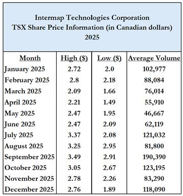
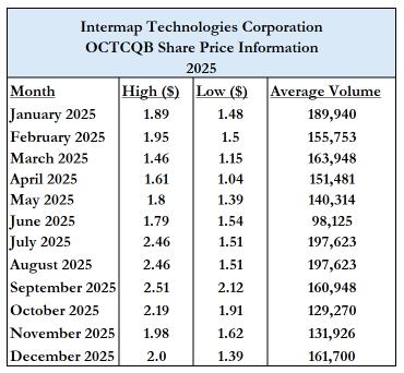
| 27 |
Prior Sales
The only securities of the Company that were outstanding as of the date of this AIF but not listed or quoted on an exchange are restricted share units and common share purchase warrants. The price at which such securities have been issued by the Company during the most recently completed financial year, the number of securities of the class issued at that price and the date on which such securities were issued, as applicable, are detailed below:
| Date | Number and Type of Securities | Issue Price/Exercise Price | Description of Issuance | |||
| February 20, 2025 | 18,000 warrants | $1.69 per warrant | Issued in connection with the February 2025 private placement | |||
| February 20, 2025 | 177,420 warrants | $1.57 per warrant | Issued in connection with the February 2025 private placement | |||
| February 20, 2025 | 122,834 warrants | $1.67 per warrant | Issued in connection with the February 2025 private placement | |||
| March 7, 2025 | 11,872 warrants | $1.68 per warrant | Issued in connection with the February 2025 private placement | |||
| September 29, 2025 | 575,046 warrants | $2.18 per warrant | Issued in connection with the September 2025 offering | |||
| September 30, 2025 | 182,658 Restricted Share Units | C$0.00 | Issued according to the Directors annual compensation plan | |||
| September 30, 2025 | 50,000 Restricted Share Units | C$0.00 | Issued as key employee incentive compensation | |||
| December 3, 2025 | 270,000 Restricted Share Units | C$0.00 | Issued as incentive compensation |
| 28 |
DIRECTORS AND EXECUTIVE OFFICERS
Set out below are the names of the directors and executive officers of the Company as of the date of this AIF, their place of residence, their positions held within the Company, and their principal occupations in the last five years.
| Name, Present Office Held and Residence | Director Since | Principal Occupation | Common Shares (5) | |||||
Patrick A. Blott(1)(3)(4) Chairman and Chief Executive Officer New York, U.S.A. | July 13, 2016 | Chairman and Chief Executive Officer of the Company, Co-Founder and Managing Partner of Blott Asset Management and Director of OSI Geospatial Inc. | 6,377,955 | |||||
Philippe Frappier(2)(3)(4) Director Toronto, Canada | January 30, 2017 | Senior Partner, BoldHouse Executive Search, and previously Human Capital and Technology Consultant, Vice President Client Services at IQ Partners, and Senior Partner of Searchlight Recruitment Inc. | 135,652 | |||||
Jordan Tongalson(2)(3)(4) Director New York, U.S.A. | September 10, 2020 | Managing Director of Littlejohn & Co, and previously Executive Director of Morgan Stanley and Vice President of The Blackstone Group L.P. | - | |||||
Notes:
| (1) | Chairman of the Board | |
| (2) | Member of Audit Committee | |
| (3) | Member of Compensation Committee | |
| (4) | Member of Nominating and Governance Committee |
| (5) | Beneficially Owned, Controlled or Directed, Directly |
The directors will hold office until the next annual general meeting of the shareholders unless their office is earlier vacated in accordance with the by-laws of the Company and in accordance with the Business Corporations Act (Alberta). As at December 31, 2025, the directors and key management personnel in aggregate owned or controlled 9.0% of the issued and outstanding Common Shares of the Company.
Executive Officers Who Are Not Directors
Jennifer S. Bakken, Executive Vice President Finance and CFO (Lone Tree, Colorado, U.S.A.) joined Intermap in August 2008 and served as the Corporate Controller until January 2017 when she was promoted to Senior Vice President. In May 2017, Jennifer was named Executive Vice President and CFO.
Jack Schneider, COO (New York, New York, USA) joined Intermap in August 2018 as a consultant before he was named COO in September 2020.
Cease Trade Orders
No director or executive officer of the Company is, as of the date of this AIF, or was, within the 10 years before the date hereof, a director, chief executive officer, or chief financial officer of any company (including the Company) that was the subject of a cease trade order, an order similar to a cease trade order, or an order that denied the Company access to any exemption under securities legislation that was in effect for a period of more than 30 consecutive days, that was issued (i) while that person was acting in such capacity; or (ii) after that person was acting in such capacity and which resulted from an event that occurred while that person was acting in such capacity.
| 29 |
Bankruptcies
No director or executive officer of the Company, or shareholder holding a sufficient number of securities to affect materially the control of the Company is, as of the date of this AIF, or has been, within 10 years before the date hereof, a director or executive officer of any company that, while that person was acting in such capacity, or within a year of that person ceasing to act in such capacity, became bankrupt, made a proposal under any legislation relating to bankruptcy or insolvency, or was subject to or instituted any proceedings, arrangement, or compromise with creditors or had a receiver, receiver manager, or trustee appointed to hold its assets.
No director or executive officer of the Company, or shareholder holding a sufficient number of securities to affect materially the control of the Company has, within the 10 years before the date of this AIF, become bankrupt, made a proposal under any legislation relating to bankruptcy or insolvency, or become subject to or instituted any proceedings, arrangement or compromise with creditors, or had a receiver, receiver manager or trustee appointed to hold the assets of the director, executive officer or shareholder.
Penalties or Sanctions
No director or executive officer of the Company, or shareholder holding a sufficient number of securities to affect materially the control of the Company has been subject to any penalties or sanctions imposed by a court relating to securities legislation or by a securities regulatory authority or has entered into a settlement agreement with a securities regulatory authority or has been subject to any other penalties or sanctions imposed by a court or regulatory body that would likely be considered important to a reasonable investor in making an investment decision.
Conflicts of Interest
Circumstances may arise where members of the Company’s board of directors or officers are directors or officers of corporations which are in competition to our interests. No assurances can be given that opportunities identified by such board members or officers will be provided to the Company. Pursuant to the Business Corporations Act (Alberta), directors who have a material interest in a proposed material transaction upon which the Company’s board of directors is voting are required to disclose their interests and refrain from voting on the transaction.
LEGAL PROCEEDINGS AND REGULATORY ACTIONS
Management of the Company is not aware of any existing or contemplated legal proceedings material to the Company, to which the Company is, or during the financial year ended December 31, 2025 was, a party or of which any of its property is, or during the financial year ended December 31, 2025 was, subject.
Management of the Company is not aware of any penalties or sanctions imposed against the Company by a court relating to securities legislation or by a securities regulatory authority during the financial year ended December 31, 2025.
INTEREST OF MANAGEMENT AND OTHERS IN MATERIAL TRANSACTIONS
There were no material interests, direct or indirect, of directors or executive officers of the Company, or of any of the shareholders of the Company who beneficially own, directly or indirectly, or exercises control or direction over more than 10 percent of the Company’s outstanding Common Shares, or any known associate or affiliate of such persons in any transactions within the three most recently completed financial years of the Company or during the current financial year which has materially affected, or is reasonably expected to materially affect, the Company or a subsidiary.
| 30 |
TRANSFER AGENT AND REGISTRAR
The Company’s transfer agent and registrar is Odyssey Trust Company, located at 300 5th Avenue SW, Calgary, Alberta, Canada T2P 3C4.
MATERIAL CONTRACTS
The Company has not entered into any material contract within the most recently completed financial year, or before the most recently completed financial year that is still in effect and was not in the ordinary course of business.
INTERESTS OF EXPERTS
There is no person or company whose profession or business gives authority to a statement made by such person or company and who is named as having prepared or certified a statement, report, or valuation described or included in a filing, or referred to in a filing, made by the Company under National Instrument 51-102 during, or related to, the Company’s most recently completed financial year other than MNP LLP, the Company’s auditors. MNP LLP are the auditors of the Entity and has advised us that they are independent of the Company in compliance with PCAOB Rule 3520 and within the meaning of the federal securities laws administered by the SEC.
In addition, none of the aforementioned persons or companies, nor any director, officer, or employee of any of the aforementioned persons or companies, is or is expected to be elected, appointed, or employed as a director, officer, or employee of the Company or of any of the Company’s affiliates.
AUDIT COMMITTEE INFORMATION
The text of Intermap Technologies Corporation’s Audit Committee Charter is attached as
Schedule A.
Composition of the Audit Committee
Applicable securities legislation requires that an audit committee be composed of a minimum of three members. The members of the Audit Committee are Mr. Jordan Tongalson (Chair)and Mr. Philippe Frappier, each of whom is independent and financially literate. The relevant education and experience of each Audit Committee member is outlined below.
Relevant Education and Experience
All members of the Audit Committee are financially literate, and all members of the committee have accounting or related financial experience.
Mr. Tongalson is currently a Managing Director and leads Business Development at Littlejohn & Company, an investment firm focused on private equity and debt investments. He previously served as Executive Director at Morgan Stanley, responsible for investment banking Industrials coverage and execution, and Vice President at The Blackstone Group, where he advised on mergers and acquisitions, structured transactions, restructuring and private equity / leveraged buyout transactions. As part of his role in each of these positions, he was required to have extensive knowledge of financial operations, including the understanding of balance sheets, income statements, and cash flow statements. Mr. Tongalson holds an MBA from Columbia Business School.
| 31 |
Mr. Frappier has been a member of the Audit Committee for four years and run an Executive Search business for the past 16 years. As part of his role, Mr. Frappier is required to have extensive knowledge of the financial operations of the Company including budgeting and forecasting, income statements, cash flow and balance sheets. Prior to his current career, Mr. Frappier oversaw multi-million-dollar production budgets in the film and television industry.
Audit Committee Oversight
All recommendations of the Audit Committee to nominate or compensate an external auditor were adopted by the Board of Directors since the commencement of its most recently completed financial year.
Pre-approval Policies and Procedures
Any engagement of non-audit services by the Company’s external auditors/accountants, including estimated fees, must be pre-approved by the Audit Committee and the Audit Committee must obtain an annual statement from the auditors regarding non-audit services.
External Auditor Service Fees
KPMG LLP served as the Company’s external auditor for the year ended December 31, 2024. MNP LLP served as the Company’s external auditor for the year ended December 31, 2025.
In aggregate, the billings by the Company’s independent registered public accounting firms for the fiscal years ended December 31, 2025 and 2024 equaled $1,075,476 and $322,225, respectively, as detailed below:
| 2025 | 2024 | |||||||||||||||
| MNP | KPMG | Total | KPMG | |||||||||||||
| Audit Fees(1) | $ | 400,000 | $ | 555,500 | $ | 955,500 | $ | 253,000 | ||||||||
| Audit-related Fees(2) | 42,121 | Nil | 42,121 | Nil | ||||||||||||
| Tax Fees(3) | 60,750 | 17,105 | 77,855 | 69,225 | ||||||||||||
| All Other Fees(4) | Nil | Nil | Nil | Nil | ||||||||||||
| Total | $ | 502,871 | $ | 572,605 | $ | 1,075,476 | $ | 322,225 | ||||||||
Notes:
(1) “Audit Fees” include fees necessary to perform the annual audit and quarterly reviews of the Company’s financial statements. Audit Fees include fees for review of tax provisions and for accounting consultations on matters reflected in the financial statements. Audit Fees also include audit or other attest services required by legislation or regulation, such as comfort letters, consents, reviews of securities filings and statutory audits.
(2) “Audit-Related Fees” include services that are traditionally performed by the auditor. These audit-related services include employee benefit audits, due diligence assistance, accounting consultations on proposed transactions, internal control reviews and audit or attest services not required by legislation or regulation.
(3) “Tax Fees” include fees for all tax services other than those included in “Audit Fees” and “Audit-Related Fees”. This category includes fees for tax compliance, tax planning and tax advice. Tax planning and tax advice includes assistance with tax audits and appeals, tax advice related to mergers and acquisitions, and requests for rulings or technical advice from tax authorities.
(4) “All Other Fees” includes all other non-audit services.
ADDITIONAL INFORMATION
Additional information relating to the Company may be found on SEDAR+ at www.sedarplus.ca. Additional information, including directors’ and officers’ remuneration and indebtedness, principal holders of the Company’s securities and securities authorized for issuance under the Company’s equity compensation plans, if applicable, is contained in the Company’s information circular for the most recent annual meeting of shareholders that involved the election of directors. Additional financial information is provided in the financial statements and management’s discussion and analysis for the year ended December 31, 2025.
| 32 |
SCHEDULE A
AUDIT COMMITTEE CHARTER
ADOPTION
This charter (Charter) was approved by the Board of Directors (Board) of Intermap Technologies Corporation (Corporation) on the date noted at the conclusion hereof.
PURPOSE
It is the policy of the Corporation to establish and maintain an Audit Committee (Committee), composed of independent directors, to assist the Board in carrying out their oversight responsibility for the Corporation’s external audit, internal controls, disclosure, financial reporting, and related risk management.
The Committee’s function is one of oversight only and shall not relieve management of its responsibilities.
The Corporation’s external auditor shall report directly to the Audit Committee.
Organization
| 1. | The Committee shall consist of a minimum of three (3) directors. |
| 2. | Each director appointed to the Committee by the Board shall be independent as such term is defined in Section 1.4 of National Instrument 52-110 and Section 3.1 of the related companion policy. |
| 3. | Each member of the Committee shall be financially literate as such term is defined in Section 1.6 of National Instrument 52-110 and at least one (1) member shall have accounting or related financial management expertise. |
| 4. | The Board shall appoint the members of the Committee and may seek the advice and assistance of the Nominating and Governance Committee in identifying qualified candidates. The Board shall appoint one (1) member of the Committee to be the Chair of the Committee. |
| 5. | A director appointed by the Board to the Committee shall be a member of the Committee until replaced by the Board or until his or her resignation. A member shall cease to be a member of the Committee upon ceasing to be a director of the Corporation. |
| 6. | The Secretary of the Corporation shall be the Secretary of the Committee. |
Responsibilities
| 7. | The Committee’s primary duties and responsibilities are to: |
| (a) | Select and recommend the nomination and compensation of the external auditors. | |
| (b) | Oversee the independence, work, and performance of the Corporation’s external auditors. |
| A-1 |
| (c) | Review the principal risks that could impact the financial reporting of the Corporation and monitor how management is dealing with such risks. | |
| (d) | Monitor the integrity of the Corporation’s disclosure and financial reporting process and its system of internal controls regarding financial reporting and accounting compliance. | |
| (e) | Monitor the Corporation’s compliance with laws, regulations, and internal policies that apply to financial or accounting matters. | |
| (f) | Oversee the resolution of any disagreements among external auditors, management, and the internal auditing department, if any. |
| 8. | The Committee shall annually select and recommend to the Board the nomination of an external auditor, recommend the replacement of the current external auditor when circumstances warrant it, and monitor the independence, work, and performance of the external auditors. This shall include: |
| (a) | Considering the views of management in respect of the nomination of the external auditors. | |
| (b) | Reviewing and recommending for approval by the Board, the terms of the external auditors’ engagement, including the reasonableness of the proposed audit fees. | |
| (c) | Pre-approving any engagement for non-audit services to be provided by the external auditors’ firm or its affiliates, together with estimated fees. This shall involve considering the potential impact of such services on the independence of the external auditors. | |
| (d) | When there is to be a change of external auditors, reviewing all issues and documentation related to the change, including the information to be included in the Notice of Change of Auditors and documentation called for under National Instrument 51-102 as defined in Section 4.11 and the planned steps for an orderly transition. | |
| (e) | Reviewing all reportable events, including disagreements, unresolved issues and consultations with external auditors, as defined by applicable securities policies, on a routine basis, whether or not there is to be a change of external auditors. |
| 9. | In carrying out its primary duties and responsibilities, the Committee shall: |
| (a) | Review the annual audit plan with the external auditors and with management. | |
| (b) | Discuss with management and the external auditors any proposed changes in major accounting policies or principles, the potential impact of significant risks and uncertainties on future operations, and key estimates and judgments of management that may be material to financial reporting. | |
| (c) | Review with management and with the external auditors significant financial reporting issues arising during the most recent fiscal period and the resolution or proposed resolution of such issues |
| A-2 |
| (d) | Review any problems experienced or concerns expressed by the external auditors in performing an audit, including any restrictions imposed by management or significant accounting issues on which there were a disagreement with management. | |
| (e) | Review periodically with management the Corporation’s disclosure controls and procedures as such term is defined in National Instrument 52-109 and monitor the certification process set out therein. | |
| (f) | Review audited annual financial statements and related documents in conjunction with the audit findings report of the external auditors and obtain an explanation from management of all significant variances between comparative reporting periods. | |
| (g) | Review with management the adequacy and effectiveness of the internal financial controls of the Corporation including any deficiencies noted in the Audit or Interim Review Findings Report and subsequent follow-up to any identified weaknesses. | |
| (h) | Review with management and the external auditors, if they have been engaged to perform review procedures, the quarterly unaudited financial statements before release to the public. | |
| (i) | Before release, review and, if appropriate, recommend for approval by the Board, all public disclosure documents containing audited or unaudited financial information including any press release, annual report, annual information form, management discussion and analysis of operations, prospectus (and all documents which may be incorporated by reference into such prospectus), and all other securities offering documents of the Corporation. | |
| (j) | Review periodically with management the internal procedures implemented to review any other public disclosure of financial information extracted or derived from the Corporation’s financial statements. | |
| (k) | Approve the hiring of any partners, employees, or former partners and employees of the Corporation’s present and former external auditor. |
| 10. | In addition, the Committee shall: |
| (a) | Oversee the receipt, review, and follow-up of questions, concerns, or complaints pursuant to the Corporation’s Code of Business Conduct and Ethics and the procedures set out in Appendix “A” thereto. | |
| (b) | Review with management, at least annually, the capital management policies, the financing strategy and funding plans of the Corporation. | |
| (c) | Review the amount and terms of any insurance to be obtained or maintained by the Corporation with respect to insurable risks inherent in its operations and potential liabilities incurred by the directors or officers in the discharge of their duties and responsibilities. | |
| (d) | In conjunction with the Nominating and Governance Committee, monitor financial and accounting personnel succession planning within the Corporation and review the appointments of the Chief Financial Officer and any key financial managers who are involved in the financial reporting process. | |
| (e) | Inquire into and determine the appropriate resolution of any conflict of interest in respect of audit or financial matters. |
| A-3 |
| (f) | Periodically review with management the need for an internal audit function. | |
| (g) | Quarterly, review any legal matter that could have a significant impact on the Corporation’s financial statements and any enquiries received from regulators or government agencies. | |
| (h) | Review periodically with management the adequacy and effectiveness of the Corporation’s policies and procedures for compliance with securities laws, regulatory requirements, and stock exchange rules. | |
| (i) | Report to the Board at the earliest opportunity after each meeting the results of its activities and any reviews undertaken and make recommendations to the Board as deemed appropriate. | |
| (j) | Bi-annually assess the performance of the Committee. | |
| (k) | Annually review the Audit Committee Charter and report to the Board on Committee compliance with the Charter. |
Meetings
| 1. | The Committee shall convene a minimum of four (4) times each year at such time and places as may be designated by the Chair of the Committee and whenever a meeting is requested by the Board, a member of the Committee, the external auditors, or a senior officer of the Corporation. |
| 2. | Notice of each meeting of the Committee shall be given to each member and to the external auditors, who shall be entitled to attend each meeting of the Committee and shall attend whenever requested to do so by a member of the Committee or the Secretary of the Committee. |
| 3. | Notice of a meeting of the Committee shall: |
| (a) | Be in writing. | |
| (b) | State the nature of the business to be transacted at the meeting in reasonable detail. | |
| (c) | To the extent practicable, be accompanied by copies of documentation to be considered at the meeting. | |
| (d) | Be given at least forty-eight (48) hours’ notice preceding the time stipulated for the meeting or such shorter period as the members of the Committee may permit. |
| 4. | A quorum for the transaction of business at a meeting of the Committee shall consist of two (2) members of the Committee. |
| 5. | A member of the Committee may participate in a meeting of the Committee by means of such telephonic, electronic, or other communication facilities, provided it permits all persons participating in the meeting to communicate adequately with each other, and a member participating in such a meeting by any such means is deemed to be present at the meeting. |
| 6. | The Chair of the Committee (Chair) shall be appointed by the Board. The Chair shall have only those responsibilities and powers delegated to it herein and shall not have a second or casting vote. The Chair shall have the responsibility of reporting annually to the Board on the Committee’s compliance with this Charter. |
| A-4 |
| 7. | In the absence of the Chair of the Committee, the members of the Committee shall choose one of the members present to be Chair of the meeting and, in the absence of the Secretary of the Committee; the members shall choose one of the persons present to be the Secretary of the meeting. |
| 8. | By invitation, the CEO and other parties may attend meetings of the Committee; however, the Committee may meet separately at any time with the external auditors, invited management, or any other third parties as determined by the Committee. |
| 9. | At each regular meeting of the Committee, the agenda shall include an opportunity for the members of the Committee to meet in-camera. |
| 10. | Minutes shall be kept of all meetings of the Committee and shall be signed by the Chair and the Secretary of the meeting. |
| 11. | Minutes of the meetings of the Committee shall be retained by the Secretary of the Corporation and shall be available on request to any member of the Board. |
Resources and Authority
| 1. | The Committee will be provided with resources commensurate with the duties and responsibilities assigned to it by the Board, including administrative support. If deemed necessary by the Committee, it will have the discretion to institute investigations of improprieties or suspected improprieties, including the standing authority to retain independent counsel or advisors and to set their compensation. |
| 2. | The Committee shall have the authority to: |
| (a) | inspect any and all of the books and records of the Corporation, its subsidiaries, and affiliates; |
| (b) | discuss with any officer of the Corporation, its subsidiaries and affiliates, the Chief Financial Officer and senior staff of the Corporation, any affected party, and external |
| (c) | auditors, such accounts, records, and other matters as any member of the Committee considers necessary and appropriate; and |
| (d) | communicate directly with the internal and external auditors. |
Approved by the Board of Directors on May 17, 2021
| A-5 |