Exhibit 96.1
Effective Date: October 30, 2024
Report Date: December 6, 2024
Prepared by:
William J. Lewis, P.Geo.
Richard Gowans, P.Eng.
Ing. Alan J. San Martin, P.Eng., MAusIMM (CP)
 |
REalloys INC. |
| 7280 W Palmetto Park Road, Suite 302N | |
| Boca Raton, Florida, 33433 | |
| Strategic Metals Development Corp. | |
| Suite 1150, 707-7 Avenue SW | |
| Calgary, Alberta, T2P 3H6 |
601 – 90 Eglinton Ave East, Toronto,
Ontario, Canada M4P 2Y3
+1 416 362 5135 | www.micon-international.com
 |
REalloys Inc. |
1.0 Executive summary
| 1.1 | Introduction |
REalloys Inc. (REalloys) has retained Micon International Limited (Micon) to independently review and verify the previous mineral resource estimate (MRE) for the Hoidas Lake Rare Earth Element (REE) Project (Hoidas Lake Project) located in the Province of Saskatchewan, Canada, and to compile an American S-K 1300 Technical Report disclosing the results of the MRE. Barr Engineering Co. (Barr) supplied the electronic resource database for the Project to Micon, as Barr had undertaken a previous MRE for the Hoidas Lake Project.
Micon’s review of the Hoidas Lake Project was based on published material researched by Micon, as well as data, professional opinions and unpublished material submitted by the professional staff of REalloys or its consultants. Much of these data came from reports prepared and provided by REalloys.
The descriptions of geology, mineralization and exploration used in this report are taken from reports prepared by various organizations and companies or their contracted consultants, as well as from various government and academic publications. The conclusions of this report use, in part, data available in published and unpublished reports supplied by the companies which have conducted exploration on the property, and information supplied by REalloys. The information provided to REalloys was supplied by reputable companies and Micon has no reason to doubt its validity. Micon has used the information where it has been verified through their own review and discussions.
In cases where photographs, figures or tables were supplied by other individuals or REalloys, the source is referenced below that item. Figures or tables generated by Micon are unreferenced.
A site visit was conducted by Micon’s QP from August 19, 2024, to August 21, 2024, to independently verify the geology, mineralogy, drilling program results and the Quality Assurance/Quality Control (QA/QC) programs at the Hoidas Lake Project. The site visit as well as the subsequent discussions and work culminated in the review and validation of the current mineral resource estimate which has an effective date of October 30, 2024.
This report discloses technical information, the presentation of which requires Micon to derive sub-totals, totals and weighted averages that inherently involve a degree of rounding and, consequently, introduce a margin of error. Where these occur, Micon does not consider them to be material.
The conclusions and recommendations of this report reflect Micon’s best independent judgment in light of the information available to it at the time of writing.
| 1.2 | Property Description |
The Hoidas Lake Project is located approximately 55 kilometres northeast of Uranium City, Saskatchewan, Canada. It consists of fourteen mineral claims comprising 12,522 hectares. The Property is centred at 59⁰55 N Latitude, 107⁰49’ W Longitude. The claims are situated on NTS map sheet 74-O-13 in the northern mining district of Saskatchewan and are contiguous. Figure 1.1 shows the location of the property.
| Hoidas Lake Rare Earth Element Property | 1 | December 6, 2024 |
|
REalloys Inc. |
Figure
1.1
Location Map for Hoidas Lake Project
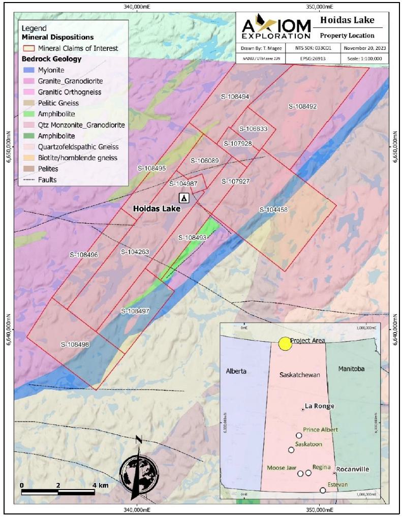
Figure supplied by REalloys and Axiom Exploration, October, 2024.
The mineral claims comprising the Hoidas Lake property are 100% owned by Strategic Metals Development Corp. (Strategic Metals). Table 1.1 summarizes Hoidas Lake Mineral Claims.
The mineral claims were originally field staked; however, the claims are not required to be surveyed, and no surveys have been performed to date. Mineral claims in Saskatchewan provide the holder with the mineral rights to the mineral disposition, as long as the appropriate fees and work commitments are met, as detailed in the ‘Mineral Tenure Registry Regulations, 2012’. These rights do not extend to the surface rights; however, they do provide legal access to the land, but with an obligation to consult with stakeholders including trappers, local First Nations, and other relevant parties.
| Hoidas Lake Rare Earth Element Property | 2 | December 6, 2024 |
|
REalloys Inc. |
Table
1.1
Hoidas Lake Mineral Claims
| Disposition Number | Mineral Claim Holder | Total
Area (ha) |
Original
Staking Date |
Expiry Date | Total
Work Credits ($CAD) |
| S-104263 | Strategic Metals Development Corp. | 1,885 | 4/1/1998 | 6/29/2028 | $141,375.43 |
| S-104458 | Strategic Metals Development Corp. | 2,334 | 10/18/2007 | 1/15/2028 | $123,702.00 |
| S-104987 | Strategic Metals Development Corp. | 72 | 9/23/1996 | 12/21/2028 | $5,400.00 |
| S-106089 | Strategic Metals Development Corp. | 477 | 4/1/1998 | 6/29/2029 | $47,950.02 |
| S-106833 | Strategic Metals Development Corp. | 300 | 4/5/2005 | 7/3/2028 | $23,400.00 |
| S-107927 | Strategic Metals Development Corp. | 331 | 7/28/2005 | 10/25/2028 | $30,121.00 |
| S-107928 | Strategic Metals Development Corp. | 244 | 7/28/2005 | 10/25/2027 | $16,114.00 |
| S-108492 | Strategic Metals Development Corp. | 1,900 | 1/27/2006 | 4/25/2028 | $148,200.00 |
| S-108493 | Strategic Metals Development Corp. | 482 | 1/27/2006 | 4/25/2028 | $37,596.00 |
| S-108494 | Strategic Metals Development Corp. | 1,043 | 1/27/2006 | 4/25/2028 | $85,429.00 |
| S-108495 | Strategic Metals Development Corp. | 642 | 1/27/2006 | 4/25/2028 | $50,075.96 |
| S-108496 | Strategic Metals Development Corp. | 665 | 1/27/2006 | 4/25/2028 | $51,870.00 |
| S-108497 | Strategic Metals Development Corp. | 889 | 1/27/2006 | 4/25/2028 | $69,342.00 |
| S-108498 | Strategic Metals Development Corp. | 1,258 | 1/27/2006 | 4/25/2028 | $98,124.00 |
| Total: | 12,522 | $928,669.41 |
Table provided by REalloys, November, 2024.
| Hoidas Lake Rare Earth Element Property | 3 | December 6, 2024 |
|
REalloys Inc. |
To maintain active status, the claims are subject to an annual work commitment of $25 per hectare per annum. For the fourteen claims, this amounts to $313,050.00. Claims can be grouped for assessment purposes.
Micon understands that, while all of the claims are currently owned by Strategic Metals, there is a 1.8% NSR royalty agreement with Norac Exploration Ltd., a company owned by a prospector by the name of R. Dubnick, which becomes payable when production begins. The NSR royalty has a maximum value of one million dollars.
There is a further reservation of interest with R. Dubnick that encompasses an area of 10 km around the original claim boundaries.
According to Billingsley, 2002, the current Hoidas Lake mineral depositions cover up to 26 known rare earth element (REO) showings discovered during the 1950s.
| 1.2.1 | REalloys Inc. (formerly Eagle Ridge Resource Inc.) Purchase Price Terms and Conditions |
In May, 2024, REalloys entered into a share purchase agreement with each of the eight original individual shareholders of Strategic Metals to acquire 100% of the company.
Subject to the terms and conditions provided for in the purchase agreement, each of the eight original individual shareholders of the vendor (Strategic Metals) agreed to sell, assign and transfer to the purchaser (REalloys) and the purchaser agreed to purchase from each of the original individual shareholders of the vendor, the purchase shares.
The purchase price to be paid by REalloys to the original individual shareholders of Strategic Metals for 100% of the company shall be an aggregate sum of USD 46,500,000, plus potential additional cash payment(s) totalling a maximum USD 3,392,500 based upon the date the cash payments as described in the purchase agreement are actually completed.
| 1.2.2 | Payment of the Purchase Price |
The purchase price shall be paid by the REalloys to Strategic Metals (or as directed by Strategic Metals), prorated in accordance with their respective holdings and set forth as follows:
| i. | As to the amount of USD 2,000,000 (first cash payment), with the payment to be made on or before June 4, 2024 (first closing date) in cash or by certified cheque. Contractual obligations were satisfied as per the purchase agreement. |
| ii. | As to the amount of USD 2,750,000, with the payment to be made on or before September 30, 2024 (second closing date) in cash or by certified cheque. Contractual obligations were satisfied as per the purchase agreement, including the payment of an additional USD 60,000 as described previously. |
601 – 90 Eglinton Ave East, Toronto,
Ontario, Canada M4P 2Y3
+1 416 362 5135 | www.micon-international.com
| Hoidas Lake Rare Earth Element Property | 4 | December 6, 2024 |
|
REalloys Inc. |
| iii. | As to the amount of USD 3,750,000, with the payment to be made on or before December 31, 2024 (third closing date) in cash or by certified cheque. Contractual obligations to be completed on or before July 31, 2025 along with an additional payment of USD 3,332,500 for a total consideration of USD 7,082,500, as described previously. |
| iv. | As to the amount of USD 38,000,000, with the issuance on the first closing date to the vendors of USD 38,000,000 worth of special warrants, having the terms and conditions described in the special warrant certificate. The purchase price special warrants shall automatically convert into USD 38,000,000 worth of Purchaser’s common shares for no additional consideration, upon completion by the purchaser of a listing or merger, reorganization, business combination, share exchange or acquisition by any person or related group of persons of beneficial ownership of all or substantially all of the purchased shares in one or more related transactions, or another similar transaction involving the purchaser, pursuant to which the shareholders of the purchaser receive cash or the securities of another issuer that are listed on a national securities exchange in the USA, as full or partial consideration for their common shares (liquidity event). In the event that the Purchaser fails to complete the liquidity event by March 31, 2026, the Purchaser shall take all necessary corporate steps to issue to each of the original individual shareholders of the vendor on a pro-rata and in aggregate amount for no additional consideration that number of voting common shares of all the Purchaser such that the Vendors own 75% of the issued and outstanding voting common shares of the Purchaser after giving effect to such issuance. |
Eagle Ridge Resources Inc. changed its name to REalloys Inc on December 4, 2024. The name change more accurately reflects the expanded mine to rare earth-metals/alloys-magnet strategy of the company.
Micon is not aware of any significant factors or risks besides those discussed in this report that may affect access, title or right or ability to perform work on the property by REalloys or any of its contractors. It is Micon’s understanding that further permitting and environmental studies would be required if the Project were to advance beyond the current exploration stage.
The Hoidas Lake Project is currently an exploration property and has no outstanding environmental liabilities from prior mining activities. The Hoidas Lake Project area is large enough to accommodate the necessary infrastructure to support a mining operation, should the economics of the mineral deposits be sufficient to warrant production.
| 1.3 | Accessibility, Climate, Physiography, Local Resources and Infrastructure |
| 1.3.1 | Accessibility |
Hoidas Lake is located approximately 55 km northeast of Uranium City, on the north side of Lake Athabasca. The site is accessed seasonally by ski- or float-equipped aircraft from Stony Rapids, 130 km southeast, or from Uranium City. Both communities have regularly scheduled commercial flights from Regina or Saskatoon. Stony Rapids has a year-round, permanent road that connects it with the southern communities. A winter road is maintained from Stony River to Uranium City.
| Hoidas Lake Rare Earth Element Property | 5 | December 6, 2024 |
|
REalloys Inc. |
| 1.3.2 | Climate |
The climate at Hoidas Lake varies seasonally from daytime high temperatures in the summer of up to 30°C and -30°C in winter, with extremes of +35°C and -45°C colder in the winter. Average monthly precipitation is 53 mm in the summer and the average snow cover in the winter is 51 cm.
| 1.3.3 | Physiography and Vegetation |
The regional topography is relatively low, but with localized, rugged relief. Hoidas Lake is at an elevation of 451 m above mean sea level (amsl). Numerous hills and ridges can extend about 100 m above nearby lakes and muskegs. Throughout this area are lakes, bogs, forest and rock outcroppings. Black spruce and jack pine are the main trees of the area. Forest fires are a concern in this area, and Fireweed (Epilobium angustifolium) occurs in burnt areas. Lichen species provide ground cover and feather mosses, such as Stair-Step Moss and Hypnum are amongst the undergrowth. Wildlife including black bear, wolverine, moose and timber wolf inhabit this region, with the migratory barren-ground caribou and associated arctic fox often appearing during winter. Birds include the common loon, greater yellowlegs, white-crowned sparrow and bald eagle, with willow ptarmigan appearing during winter. In the lakes are fish including lake trout, arctic grayling, whitefish, walleye and northern pike.
Rock outcrop exposure is generally poor, with less than 5% bedrock surface exposure within the Hoidas Lake property. Glacial outwash and till deposits cover and obscure much of the bedrock. Drainage from the area follows the Tazin River into Great Slave Lake in the Northwest Territories.
| 1.3.4 | Local Resources and Infrastructure |
Local infrastructure and resources are limited in scope. There are some local aggregate deposits near the Project, but the closest permanent housing, buildings, or light industries are found in Uranium City. The closest permanent road is located at Stony Rapids, which has a larger population base.
The camp will need to be re-established for any further exploration activities or more advanced activities at the site.
| 1.4 | History |
| 1.4.1 | 1936 to 1965 |
In 1936, regional geological mapping of the area was undertaken by the Geological Survey of Canada (GSC). In 1950, the original recorded claims at the Hoidas Lake property were staked. Trenching of the main exposure occurred, but there are limited records due to government restrictions on uranium development, at the time. In 1955, D. Hogarth noted the occurrence of thorium in association with REE bearing apatite and hyalophane during a mineralogical investigation at Hoidas Lake. In 1961, an airborne radiometric and electromagnetic survey was undertaken by the Canadian Aero Service on Mineral Permit No. 1, which included the Hoidas Lake area. In 1965, six claims were staked to cover the main showings at Hoidas Lake. Radiometric surveys were conducted by the Globe Exploration Syndicate and widths of 2 m to 5 m along a strike length of 425 m were reported.
| Hoidas Lake Rare Earth Element Property | 6 | December 6, 2024 |
|
REalloys Inc. |
| 1.4.2 | 1980 to 1999 |
In 1980, the Hemmingson claims were acquired by Kintla Explorations Limited (Kintla) and used for uranium and thorium exploration.
In 1996, six new claims were staked at Hoidas Lake. These were vended to Daren Resources Limited (Daren Resources) and, subsequently, the first metallurgical work on Hoidas Lake samples was conducted. The results showed recoveries of 97.6% for the REE through gravity concentration and hydrochloric acid leaching. In 1999, Great Western Minerals Group Ltd. (Great Western Minerals) performed a trenching and sampling program at Hoidas Lake, intersecting several REE-bearing veins and petrographic, assay, and geochemical studies were undertaken on the samples.
| 1.4.3 | 1999 to 2012 |
In 2001, the first drilling program at Hoidas Lake was conducted by Great Western Minerals. Magnetometer and very-low-frequency-electromagnetic (VLF-EM) surveys were also conducted at this time. Also in 2001, analytical and metallurgical testwork was done on the drill core by Lakefield Research Ltd. (Lakefield Research). This work included the viability of concentration and dissolution of what is now termed the JAK Zone, and some initial environmental testing. A number of new elements were identified in the Hoidas Lake mineralization through this work. In 2004, Great Western Minerals acquired a 2,000 kg bulk sample through regional prospecting. A budget and work program for future development at the property was proposed. The program extended the geophysical coverage of the property, provided infill drilling of the 2001 program, and recommended further metallurgical testing and commencement of environmental baseline studies. Also in 2004, further mineralogical work on 2001 drill core was undertaken.
In 2005, a second drilling program was undertaken. Additionally, magnetometer and VLF-EM surveys were extended to tie into the work from the 2001 program and aerial photogrammetry began with some over flights.
In the winter of 2006, a third drilling program was undertaken at Hoidas Lake. The results confirmed the continuity of the vein system along strike of the northern half of the JAK Zone, as well as further delineating the Hanging Wall Zone intersected in 2005.
In the summer of 2006, a land-based VLF-EM survey work was carried out. This was an extension of the 2005 work that could not be completed due to weather conditions. In the winter of 2007, a bulk sample was taken at the JAK Zone from 32 diamond core drill holes, constituting the fourth drilling program at Hoidas Lake. A total of 13.8 tonnes of metallurgical sample were extracted for use as feed for pilot-plant-scale testing.
A fifth drilling program took place in the winter and summer of 2008 which included a geotechnical investigation for a possible future tailings pond location at Hoidas Lake. The fifth drilling program was designed to extend the strike and dip of the JAK Zone.
| Hoidas Lake Rare Earth Element Property | 7 | December 6, 2024 |
|
REalloys Inc. |
Figure 1.2 shows collar locations of the 2005 to 2008 drill holes that intercepted the JAK Zone.
Figure
1.2
Plan Map of the Collar Locations of the 2005 to 2008 JAK Zone Drill Holes
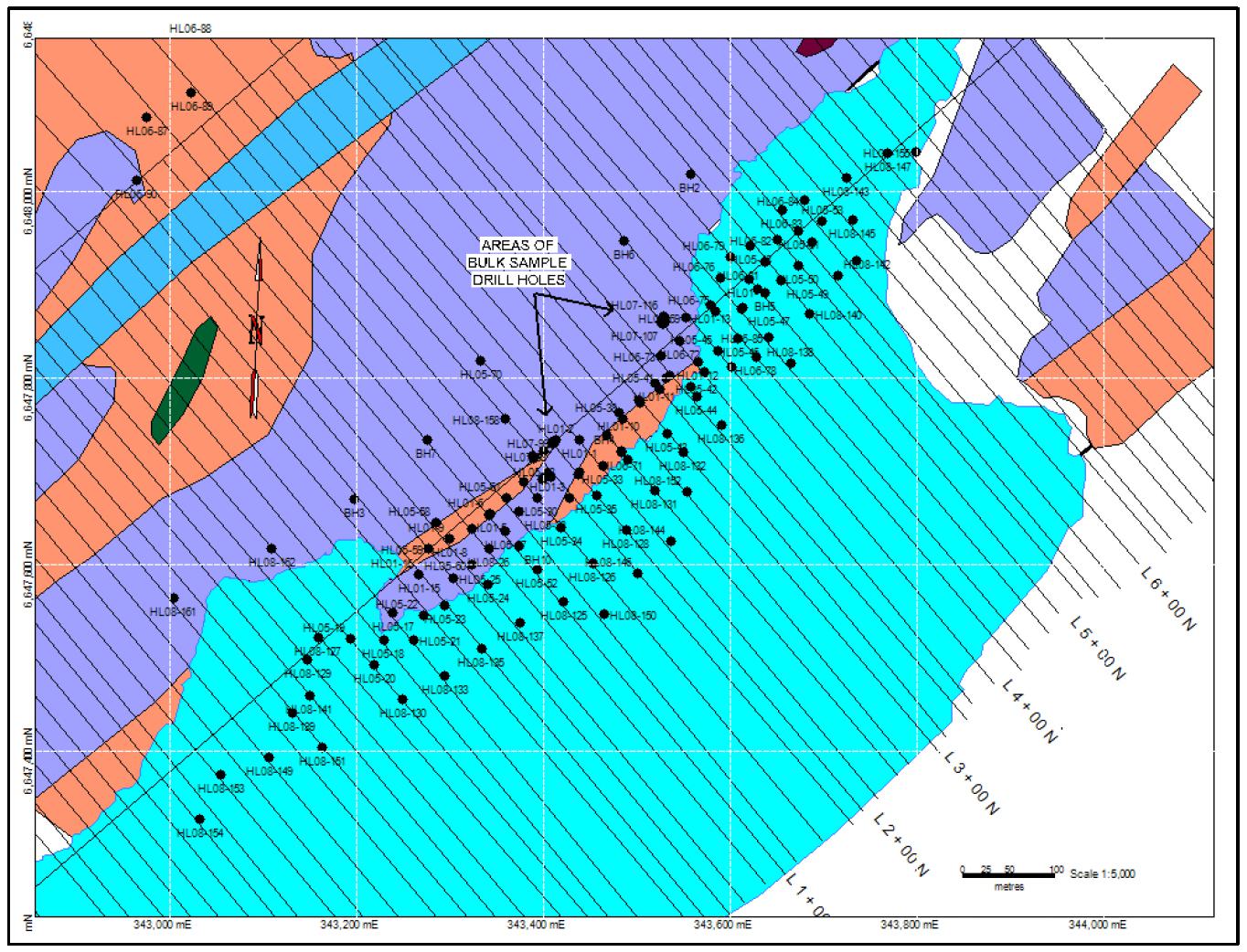
Figure taken from the 2014 Barr Technical Report. For Geology Legend see Figure 1.4.
Table 1.2 shows drill hole data for assayed JAK Zone interceptions. Table 1.3 shows the significant drill intersections for each drill hole that tested the JAK Zone. Mineralized intercepts listed are those considered significant from a geological and zone continuity perspective. Generally, mineralized intercepts of greater than 1 m and greater than 1% TREO are included.
A mapping and radiometric prospecting program was carried out during the summer of 2012. with three main areas of interest being located and several isolated occurrences of mineralization were also found.
| 1.4.4 | 2012 to 2024 |
No work was done on the property after the summer of 2012 to September, 2024.
| Hoidas Lake Rare Earth Element Property | 8 | December 6, 2024 |
|
REalloys Inc. |
Table
1.2
2001 to 2008 JAK Zone Drill Hole Information
| Year | Drill
Hole Number |
Grid East | Grid North | Elevation
(m) |
Azimuth
(°) |
Dip
(°) |
Drill
Hole Length (m) |
Number
of Samples |
Sample Number Range |
| 2001 | HL01-01 | 17.65 | 223.71 | 454.63 | 315 | -45 | 45 | 15 | 40032 - 40045 |
| HL01-02 | 17.65 | 223.71 | 454.63 | 315 | -65 | 61 | 39 | 40291 - 40329 | |
| HL01-03 | 22.12 | 173.89 | 453.11 | 315 | -45 | 50 | 47 | 40125 - 40171 | |
| HL01-04 | 27.69 | 173.9 | 452.91 | 315 | -65 | 62 | 33 | 40442 - 40474 | |
| HL01-05 | 13.96 | 98.41 | 454.75 | 315 | -45 | 50 | 0 | ||
| HL01-06 | 13.96 | 98.41 | 454.75 | 315 | -41 | 41 | 24 | 40475 - 40498 | |
| HL01-07 | 13.96 | 98.41 | 454.75 | 315 | -65 | 62 | 30 | 40412 - 40441 | |
| HL01-08 | 7.22 | 49.16 | 452.94 | 315 | -45 | 40 | 29 | 40046 - 40074 | |
| HL01-09 | 7.22 | 49.16 | 452.94 | 315 | -65 | 63.5 | 50 | 40075 - 40124 | |
| HL01-10 | 23.08 | 273.92 | 454.79 | 315 | -45 | 77 | 27 | 41018 - 41046 | |
| HL01-11 | 24.09 | 323.87 | 455.2 | 315 | -45 | 89 | 30 | 44088
– 44100, 41001 - 41017 | |
| HL01-12 | 37.16 | 373.72 | 451.27 | 315 | -45 | 91.7 | 51 | 44046 - 44087, 836712 - 836721 | |
| HL01-13 | -0.63 | 423.46 | 451.24 | 315 | -50 | 68 | 47 | 40499 - 44045 | |
| HL01-14 | 4.61 | 473.3 | 451.08 | 315 | -50 | 100 | 119 | 40172 - 40290 | |
| HL01-15 | 14.85 | -1.07 | 452.08 | 315 | -45 | 50 | 10 | 40401 - 40410 | |
| HL01-16 | 14.18 | -1.13 | 452.03 | 315 | -65 | 110 | 72 | 40330 - 40400, | |
| 2001 Total Metres | 1,060.2 | ||||||||
| 2005 | HL05-17 | 27.76 | -49.15 | 452.26 | 315 | -50 | 68 | 26 | 782201 - 782228 |
| HL05-18 | 43.29 | -75.43 | 451.15 | 315 | -65 | 86 | 12 | 782230 - 782242 | |
| HL05-19 | 18.82 | -101.21 | 451.13 | 315 | -62 | 80 | 15 | 782243 - 782258 | |
| HL05-20 | 57.01 | -100.51 | 451.14 | 315 | -70 | 119 | 10 | 782260 - 782270 | |
| HL05-21 | 63.94 | -50.93 | 451.15 | 315 | -70 | 140 | 30 | 12101 - 12105, 782271 - 782294, 12299 | |
| HL05-22 | 50.77 | -25.85 | 451.25 | 315 | -63 | 101 | 21 | 12300, 37001 - 37007, 782295 - 782307 | |
| HL05-23 | 57.46 | -1.16 | 451.3 | 315 | -70 | 123.5 | 24 | 782308 - 782331, 37009 - 37010 | |
| HL05-24 | 71.19 | 48.17 | 451.17 | 315 | -65 | 140 | 29 | 782332 - 782361, 37011 - 37012 | |
| HL05-25 | 41.75 | 23.65 | 452.48 | 315 | -65 | 104 | 23 | 782362 - 782381, 37075 - 37079 | |
| Hoidas Lake Rare Earth Element Property | 9 | December 6, 2024 |
|
REalloys Inc. |
| Year | Drill
Hole Number |
Grid East | Grid North | Elevation
(m) |
Azimuth
(°) |
Dip
(°) |
Drill
Hole Length (m) |
Number
of Samples |
Sample Number Range |
| HL05-26 | 42.46 | 73.88 | 453.05 | 315 | -65 | 115 | 21 | 782382 - 782402, 37013 - 37014 | |
| HL05-27 | 40.4 | 99.09 | 454 | 315 | -70 | 119 | 33 | 782403 - 782433, 37015 - 37019 | |
| HL05-28 | 33.12 | 123.37 | 454.79 | 315 | -65 | 53 | 10 | 782434 - 782443, 12106 | |
| HL05-29 | 32.79 | 123.73 | 454.79 | 315 | -55 | 86 | 14 | 782444 - 782453, 37020 - 37022, 37080 - 37081 | |
| HL05-30 | 34.87 | 148.58 | 452.5 | 315 | -53 | 86 | 14 | 782455 - 782466, 370223 - 37024 | |
| HL05-31 | 57.74 | 174.3 | 451.72 | 315 | -60 | 128 | 35 | 782468 - 782500, 799101 - 799105 | |
| HL05-32 | 44.48 | 198.78 | 452.92 | 315 | -53 | 93.7 | 26 | 799106 - 799134 | |
| HL05-33 | 55.15 | 223.86 | 453.13 | 315 | -60 | 125 | 19 | 799135 - 799155 | |
| HL05-34 | 75.79 | 147.44 | 451.18 | 315 | -70 | 170 | 28 | 799156 - 799186 | |
| HL05-35 | 74.01 | 198.94 | 451.2 | 315 | -70 | 173 | 22 | 799187 - 799211 | |
| HL05-36 | 66.73 | 249.3 | 451.27 | 315 | -65 | 122 | 17 | 799212 - 799230 | |
| HL05-37 | 32.31 | 248.88 | 454.36 | 315 | -53 | 93.2 | 29 | 799231 - 799264 | |
| HL05-38 | 29.89 | 273.53 | 454.62 | 315 | -65 | 113 | 18 | 799265 - 799283 | |
| HL05-39 | 29.89 | 273.53 | 454.62 | 315 | -53 | 89 | 21 | 799284 - 799306 | |
| HL05-40 | 26.93 | 298.67 | 454.88 | 315 | -53 | 77 | 25 | 799308 - 799330, 37028 | |
| HL05-41 | 32.78 | 324.02 | 455.07 | 310 | -65 | 110 | 24 | 799331 - 799355, 37029 - 37030 | |
| HL05-42 | 28.83 | 342.09 | 454.69 | 315 | -53 | 98 | 41 | 799356 - 799390, 37031 - 37040 | |
| HL05-43 | 73.48 | 298.98 | 451.13 | 315 | -53.9 | 137 | 21 | 799391 - 799407, 37041 - 37046 | |
| HL05-44 | 63.45 | 349.07 | 451.18 | 315 | -53.9 | 137 | 26 | 799408 - 799429, 37047 - 37052 | |
| HL05-45 | 41.64 | 398.14 | 451.19 | 315 | -53.9 | 110 | 29 | 782332 - 782361, 37011 - 37012 | |
| HL05-46 | 45.11 | 423.14 | 451.22 | 315 | -54 | 116 | 43 | 799455 - 799495, 37060 - 37065 | |
| HL05-47 | 23.14 | 448.08 | 451.19 | 315 | -54 | 101 | 35 | 799497 - 799500, 12201 - 12223, 37069 - 37074 | |
| HL05-48 | -21.5 | 498.02 | 451.18 | 315 | -54 | 65 | 37 | 12227 - 12262 | |
| HL05-49 | 28.83 | 497.93 | 451.19 | 315 | -54 | 122 | 29 | 12263 - 12294 | |
| HL05-50 | 28.61 | 522.75 | 451.2 | 315 | -54 | 122 | 30 | 37082 - 37714 | |
| HL05-51 | 1.02 | 547.04 | 451.19 | 315 | -54 | 97.6 | 39 | 37716 - 37757 | |
| HL05-52 | 93.48 | 98.28 | 451.21 | 315 | -62 | 170 | 31 | 37758 - 37792 | |
| HL05-53 | 8.95 | 573.12 | 451.21 | 315 | -55 | 113 | 15 | 37813 -37828 |
| Hoidas Lake Rare Earth Element Property | 10 | December 6, 2024 |
|
REalloys Inc. |
| Year | Drill
Hole Number |
Grid East | Grid North | Elevation
(m) |
Azimuth
(°) |
Dip
(°) |
Drill
Hole Length (m) |
Number
of Samples |
Sample Number Range |
| HL05-54 | 18.52 | 550.1 | 451.2 | 315 | -65 | 122 | 17 | 37829 - 37847 | |
| HL05-55 | 15.38 | 98.25 | 454.6 | 315 | -52 | 41 | 10 | 837012 - 837022 | |
| HL05-56 | 15.23 | 99.03 | 454.73 | 315 | -52 | 74 | 10 | 837001 - 837011 | |
| HL05-57 | 14.73 | 74.07 | 454.19 | 315 | -65 | 80 | 9 | 837023 - 837032 | |
| HL05-58 | -16.31 | 48.83 | 452.31 | 315 | -45 | 44 | 7 | 837033 - 837040 | |
| HL05-59 | 0.18 | 24.15 | 452.02 | 315 | -75 | 65 | 17 | 837041 - 837060 | |
| HL05-60 | 43.36 | 49.64 | 453.5 | 315 | -65 | 116 | 14 | 837061 - 837077 | |
| HL05-61 | 13.55 | 122.96 | 453.7 | 315 | -55 | 65 | 14 | 837078 - 837093 | |
| HL05-62 | 13.26 | 148.76 | 453.81 | 315 | -53 | 62 | 15 | 837095 - 837112 | |
| HL05-63 | 0.74 | 173.72 | 453.88 | 315 | -52 | 56 | 5 | 837113 - 837119 | |
| HL05-68 | 29.87 | 298.2 | 454.7 | 315 | -65 | 104 | 26 | 837120 - 837149 | |
| HL05-69 | -7.77 | 395.72 | 452.52 | 316 | -65 | 62 | 19 | 837150 - 837170 | |
| HL05-70 | -116.34 | 198.82 | 455.97 | 315 | -53 | 50 | 7 | 837171 - 837178 | |
| 2005 Total Metres: | 5,044 | ||||||||
| 2006 | HL06-71 | 56.64 | 249.39 | 451.92 | 315 | -55 | 140 | 19 | 837201 - 837221 |
| HL06-72 | 6.56 | 373.94 | 453.91 | 315 | -55 | 59 | 25 | 837222 - 837249 | |
| HL06-73 | 6.28 | 348.84 | 454.99 | 315 | -55 | 77 | 21 | 837250 - 837272 | |
| HL06-74 | 49.19 | 372.3 | 451.38 | 315 | -60 | 122 | 46 | 837273 - 837323 | |
| HL06-75 | 8.44 | 423.48 | 451.32 | 315 | -60 | 86 | 22 | 837325 - 837347 | |
| HL06-76 | -15.6 | 451.32 | 451.41 | 315 | -60 | 71.6 | 25 | 837348 - 837374 | |
| HL06-77 | 24.21 | 445.93 | 451.32 | 330 | -60 | 176 | 42 | 837376 - 837422 | |
| HL06-78 | 73.6 | 424.44 | 451.27 | 315 | -60 | 86 | 19 | 837423 - 837443 | |
| HL06-79 | -25.99 | 473.51 | 451.32 | 315 | -60 | 59 | 26 | 837445 - 837472 | |
| HL06-80 | 19.6 | 473.15 | 451.33 | 315 | -60 | 128 | 33 | 837473 - 837500, 836601 - 836609 | |
| HL06-81 | 2.33 | 498.1 | 451.25 | 315 | -60 | 98 | 36 | 836610 - 836649 | |
| HL06-82 | -7.72 | 523.42 | 451.25 | 315 | -60 | 86 | 31 | 836650 - 836683 | |
| HL06-83 | -27.63 | 548.11 | 451.23 | 315 | -60 | 62 | 9 | 836684 - 836693 | |
| HL06-84 | -19.79 | 573.51 | 451.25 | 315 | -60 | 80 | 16 | 836694 - 836711 | |
| HL06-85 | 66.17 | 447.87 | 451.24 | 315 | -60 | 158 | 59 | 836722 - 836786 | |
| HL06-86 | -630 | 400 | 435.23 | 315 | -55 | 98 | 15 | 836788 - 836803 | |
| Hoidas Lake Rare Earth Element Property | 11 | December 6, 2024 |
|
REalloys Inc. |
| Year | Drill
Hole Number |
Grid East | Grid North | Elevation
(m) |
Azimuth
(°) |
Dip
(°) |
Drill
Hole Length (m) |
Number
of Samples |
Sample Number Range |
| HL06-87 | -546.28 | 97.45 | 442.33 | 315 | -55 | 110 | 24 | 836805 - 836830 | |
| HL06-88 | -600 | 204.31 | 440.55 | 315 | -55 | 86 | 12 | 836831 - 836843 | |
| HL06-89 | -535.64 | 151.11 | 442.35 | 315 | -55 | 107 | 18 | 836844 - 836863 | |
| HL06-90 | -503.2 | 45.12 | 444.61 | 315 | -55 | 143 | 15 | 836865 - 836880 | |
| HL06-91 | -420.9 | 848.55 | 435.2 | 315 | -60 | 65 | 30 | 836881 - 836913 | |
| HL06-92 | -611.19 | 849.69 | 435.19 | 315 | -60 | 128 | 45 | 836914 - 836963 | |
| 2006 Total Metres | 2,225.6 | ||||||||
| 2008 | HL08-125 | 137.66 | 97.69 | 451.27 | 315 | -65 | 291 | 96 | 948801 - 948897, 201918 - 201926 |
| HL08-126 | 126.73 | 147.97 | 451.25 | 315 | -65 | 278 | 70 | 948898 - 948966, 201940 - 201946 | |
| HL08-127 | -4.83 | -126.53 | 451.23 | 315 | -64 | 89 | 11 | 201124 - 201133 | |
| HL08-128 | 123.38 | 198.32 | 451.14 | 315 | -60 | 215 | 25 | 948997 - 948999, 201001 - 201020 | |
| HL08-129 | 6.04 | -151.02 | 451.21 | 315 | -64 | 65 | 27 | 948967 - 948996 | |
| HL08-130 | 105.04 | -101.09 | 451.18 | 315 | -65 | 189 | 23 | 201173 - 201192, 201935 | |
| HL08-131 | 110.36 | 249.32 | 451.22 | 315 | -65 | 236 | 47 | 201021 - 201066, 201950 - 201954 | |
| HL08-132 | 99.67 | 298.54 | 451.17 | 315 | -65 | 275 | 63 | 201067 - 201123, 201967 - 201971 | |
| HL08-133 | 115.21 | -50.72 | 451.05 | 315 | -65 | 200 | 19 | 201193 - 201209 | |
| HL08-134 | 64.49 | 398.36 | 451.17 | 315 | -65 | 316 | 38 | 201210 - 201248, 201972 - 201973 | |
| HL08-135 | 118.25 | -2.34 | 451.15 | 315 | -65 | 221 | 35 | 201135 - 201172 | |
| HL08-136 | 104.89 | 348.59 | 451.09 | 315 | -65 | 289 | 37 | 201249 - 201290 | |
| HL08-137 | 124.42 | 48.13 | 451.18 | 315 | -65 | 227 | 63 | 201291 - 201345, 201904 - 201917 | |
| HL08-138 | 101.84 | 448.35 | 451.24 | 315 | -65 | 245 | 97 | 201346 - 201440, 201974 - 201983 | |
| HL08-139 | 38.65 | -200.7 | 451.21 | 315 | -65 | 134 | 34 | 201441 - 201476, 201927 | |
| HL08-140 | 74.72 | 498.04 | 451.19 | 315 | -65 | 245 | 66 | 201477 - 201500, 202001 - 202050 | |
| HL08-141 | 36.52 | -174.72 | 451.19 | 315 | -65 | 119 | 31 | 202051 - 202082, 201902 - 201903 | |
| HL08-142 | 64.2 | 547.72 | 451.21 | 315 | -65 | 194 | 38 | 202083 - 202124 | |
| HL08-143 | -9.52 | 622.75 | 451.15 | 315 | -65 | 140 | 18 | 202125 - 202145 | |
| HL08-144 | 163.38 | 226.14 | 451.28 | 315 | -65 | 398 | 55 | 202189 - 202243 | |
| HL08-145 | 29.36 | 598.38 | 451.18 | 315 | -65 | 200 | 14 | 202146 - 202160 | |
| HL08-146 | 166.3 | 176.58 | 451.15 | 315 | -65 | 338 | 51 | 202244 - 202306 | |
| HL08-147 | -0.34 | 673.35 | 451.18 | 315 | -65 | 151 | 25 | 202161 - 202188 | |
| HL08-149 | 58.68 | -250.13 | 451.15 | 315 | -65 | 173 | 20 | 202307 - 202329 | |
| HL08-150 | 176.51 | 121.82 | 451.22 | 315 | -65 | 398 | 88 | 202365 - 202461 | |
| HL08-151 | 88.36 | -200.26 | 451.01 | 315 | -65 | 197 | 34 | 202330 - 202364, 201928 | |
| HL08-152 | 135.04 | 274.34 | 451.17 | 315 | -65 | 305 | 81 | 201547 - 201636, 201959 | |
| HL08-153 | 38.94 | -300.93 | 451.13 | 315 | -65 | 118 | 40 | 201503 - 201546 | |
| HL08-154 | 60.36 | -349.46 | 451.23 | 315 | -65 | 194 | 38 | 202462 - 202500, 201901, 201501 - 201502 | |
| HL08-155 | 18.75 | 697.84 | 451.24 | 315 | -65 | 140 | 45 | 201637, 201682, 201840 | |
| HL08-156 | 64.4 | 573.32 | 451.1 | 315 | -65 | 203 | 48 | 201683 - 201735 | |
| HL08-157 | 41.4 | 200 | 451 | 045 | -63 | 110 | 19 | 202501 - 202520 | |
| 2008 Total Metres | 6,893 | ||||||||
Table taken from the 2014 Barr Technical Report.
| Hoidas Lake Rare Earth Element Property | 12 | December 6, 2024 |
|
REalloys Inc. |
Table
1.3
Significant Drill Hole Intersections for the JAK Zone
| Year | Drill
Hole Number |
Grid
East |
Grid
North |
Mineralized Interval | Assay | ||||
| From
(m) |
To
(m) |
Core
Length (m) |
True
Width (m) |
TREO
(%) |
P2O5% | ||||
| 2001 | HL01-01 | 17.65 | 223.71 | 19.6 | 23.3 | 3.7 | 3.75 | 1.07 | |
| HL01-02 | 17.65 | 223.71 | 21.3 | 27.49 | 6.19 | 6.22 | 1.52 | ||
| HL01-03 | 22.12 | 173.89 | 14.9 | 17.8 | 2.9 | 3.67 | 4.38 | ||
| HL01-04 | 27.69 | 173.9 | 30.4 | 32.7 | 2.3 | 2.09 | 3.28 | ||
| HL01-05 | 13.96 | 98.41 | No Significant Assays | ||||||
| HL01-06 | 13.96 | 98.41 | 28.4 | 31.4 | 3 | 2.72 | 2.49 | ||
| HL01-07 | 13.96 | 98.41 | 38.1 | 43.9 | 5.8 | 5.2 | 3.84 | ||
| HL01-08 | 7.22 | 49.16 | 19.5 | 27 | 7.5 | 6.75 | 3.84 | ||
| HL01-09 | 7.22 | 49.16 | 26 | 31.7 | 5.7 | 4.8 | 4.3 | ||
| HL01-10 | 23.08 | 273.92 | 39.7 | 51.3 | 11.6 | 8.13 | 1.34 | ||
| HL01-11 | 24.09 | 323.87 | 41.9 | 49.8 | 7.9 | 6.33 | 1.48 | ||
| HL01-12 | 37.16 | 373.72 | 59.2 | 66.7 | 7.5 | 6.05 | 1.72 | ||
| 72.9 | 76.4 | 3.5 | 3.34 | 2.96 | |||||
| HL01-13 | -0.63 | 423.46 | 31.9 | 41.6 | 9.7 | 7.75 | 2.85 | ||
| HL01-14 | 4.61 | 773.3 | 51.7 | 54.6 | 2.9 | 2.69 | 1.78 | 2.08 | |
| 68.1 | 75 | 6.9 | 6.85 | 4.41 | |||||
| HL01-15 | 14.85 | -1.07 | 30.8 | 32.8 | 2 | 1.93 | 1.31 | ||
| HL01-16 | 14.18 | -1.13 | 36 | 40.8 | 4.8 | 3.83 | 3.26 | ||
| 54.5 | 59.2 | 4.7 | 3.21 | 0.83 | |||||
| 2005 | HL05-17 | 27.76 | -49.15 | 43.85 | 46.5 | 2.65 | 2.51 | 3.98 | 11.34 |
| 54.75 | 58.2 | 3.45 | 3.3 | 2.37 | 9.91 | ||||
| HL05-18 | 43.29 | -75.43 | 70.5 | 74.4 | 3.9 | 2.97 | 0.708 | 3.96 | |
| HL01-19 | 18.82 | -101.21 | 34.65 | 37.55 | 2.9 | 2.16 | 1.24 | 5.26 | |
| 47 | 53 | 6 | 4.05 | 1.7 | 2.68 | ||||
| HL05-20 | 57.01 | -100.51 | 88.5 | 91 | 2.5 | 2.1 | 1.64 | 2.74 | |
| HL05-21 | 63.94 | -50.93 | 98.6 | 101.4 | 2.8 | 2.21 | 2.36 | 15.7 | |
| 109.53 | 119.8 | 10.27 | 7.27 | 1.15 | 11.74 | ||||
| HL05-22 | 50.77 | -25.85 | 72.88 | 76.1 | 3.22 | 2.97 | 3.28 | 23.56 | |
| 84.54 | 88.1 | 3.56 | 3.11 | 2.35 | 10.05 | ||||
| HL05-23 | 57.46 | -1.16 | 90.76 | 92.35 | 1.59 | 1.41 | 2.64 | 16.29 | |
| 111 | 113 | 2 | 1.62 | 1.92 | 8.87 | ||||
| HL05-24 | 71.19 | 48.17 | 97.6 | 105.2 | 7.6 | 5.91 | 3.28 | 19.8 | |
| 126.63 | 129.95 | 3.32 | 2.15 | 1.4 | 5.98 | ||||
| HL05-25 | 41.75 | 23.65 | 66 | 70.5 | 4.5 | 3.44 | 0.772 | 3.11 | |
| 86.96 | 91.37 | 4.41 | 4.19 | 0.733 | 3.24 | ||||
| HL05-26 | 42.46 | 73.88 | 71.14 | 74.88 | 3.74 | 3.06 | 1.7 | 10.56 | |
| 96.33 | 105 | 8.67 | 5.75 | 1.41 | 1.96 | ||||
| HL05-27 | 40.4 | 99.09 | 71.45 | 83.05 | 11.6 | 8.76 | 4.01 | 15.04 | |
| 104.5 | 109.4 | 4.9 | 2.75 | 4.03 | 20.99 | ||||
| HL05-28 | 33.12 | 123.37 | 48.08 | 53 | 4.92 | 4.2 | 2.25 | 12.5 | |
| HL05-29 | 32.79 | 123.73 | 47 | 52.5 | 5.5 | 3.4 | 3.64 | 11.55 | |
| 76.42 | 78.85 | 2.43 | 20.6 | 0.728 | 3.34 | ||||
| Hoidas Lake Rare Earth Element Property | 13 | December 6, 2024 |
|
REalloys Inc. |
| Year | Drill
Hole Number |
Grid
East |
Grid
North |
Mineralized Interval | Assay | ||||
| From
(m) |
To
(m) |
Core
Length (m) |
True
Width (m) |
TREO
(%) |
P2O5% | ||||
| HL05-30 | 34.87 | 148.58 | 39.7 | 42.48 | 2.78 | 2.44 | 2.59 | 15.05 | |
| 76.1 | 79.12 | 3.02 | 2.78 | 0.22 | 4.77 | ||||
| HL05-31 | 57.74 | 174.3 | 20.14 | 23.05 | 2.91 | 2.51 | 3.62 | 17.07 | |
| 27.18 | 29.38 | 2.2 | 1.91 | 3 | 26.39 | ||||
| 60.68 | 67.23 | 6.55 | 5.38 | 2.1 | 11.04 | ||||
| HL05-32 | 44.48 | 198.78 | 27 | 35.05 | 8.05 | 6.63 | 1.09 | 6.9 | |
| 42.33 | 46.5 | 4.17 | 3.72 | 4.43 | 13.07 | ||||
| HL05-33 | 55.15 | 223.86 | 51.3 | 54.2 | 2.9 | 2.1 | 0.84 | 6.5 | |
| 108.6 | 114.3 | 5.7 | 3.74 | 3.12 | 14.06 | ||||
| HL05-34 | 75.79 | 147.44 | 91.55 | 94.68 | 3.13 | 2.02 | 2.74 | 15.81 | |
| 99.1 | 100.62 | 1.52 | 1.22 | 4.2 | 15.93 | ||||
| 156 | 162.9 | 6.9 | 4.65 | 0.96 | 3.73 | ||||
| HL05-35 | 74.01 | 198.94 | 80.08 | 82.95 | 2.87 | 2.12 | 2.11 | 14.41 | |
| 88.65 | 91.35 | 2.7 | 1.91 | 4.05 | 18.39 | ||||
| HL05-36 | 66.73 | 249.3 | 53.6 | 54.94 | 1.34 | 1 | 1.27 | 5.55 | |
| HL05-37 | 32.31 | 248.88 | 59.9 | 66.5 | 6.6 | 4.42 | 2.43 | 10.72 | |
| 78.7 | 87.7 | 9 | 8 | 2.36 | 12.04 | ||||
| HL05-38 | 29.89 | 273.53 | 84.35 | 94.7 | 10.35 | 5.24 | 2.82 | 14.96 | |
| HL05-39 | 29.89 | 273.53 | 62.1 | 67.35 | 5.25 | 3.12 | 3.09 | 25.3 | |
| 70.64 | 77.65 | 7.01 | 4.51 | 1.93 | 10.48 | ||||
| HL05-40 | 26.93 | 298.67 | 54.35 | 57 | 2.65 | 1.43 | 2.54 | 13.8 | |
| 60 | 68.7 | 8.7 | 6.31 | 2.03 | 9.8 | ||||
| HL05-41 | 32.78 | 324.09 | 78.2 | 91.1 | 12.9 | 7.08 | 1.55 | 5.15 | |
| HL05-42 | 28.83 | 342.09 | 20.8 | 22.2 | 1.4 | 1.2 | 1.45 | 0.814 | |
| 26.7 | 28.8 | 2.1 | 1.8 | 1.2 | 0.95 | ||||
| 64.34 | 72.1 | 7.76 | 6.1 | 2.59 | 12.33 | ||||
| 74.9 | 78.4 | 3.5 | 3.03 | 1.62 | 8.06 | ||||
| 80.7 | 84.75 | 4.05 | 3.5 | 3.09 | 17.5 | ||||
| HL05-43 | 73.48 | 298.98 | 85.5 | 88.5 | 3 | 2.23 | 2.21 | 7.6 | |
| 119.36 | 122.6 | 3.24 | 2.74 | 1.91 | 4.44 | ||||
| HL05-44 | 63.45 | 349.07 | 55.7 | 59.7 | 4 | 3.32 | 2.55 | 26.09 | |
| 108.53 | 113.78 | 5.25 | 3.19 | 2.41 | 11.62 | ||||
| HL05-45 | 41.64 | 398.14 | 8.91 | 12.1 | 3.19 | 2.61 | 7.46 | 8.45 | |
| 78.1 | 80.6 | 2.5 | 2.2 | 2.68 | 12.71 | ||||
| 92.85 | 95.97 | 3.12 | 2.13 | 2.37 | 7.54 | ||||
| 98.93 | 102.53 | 3.6 | 2.83 | 3.81 | 24.07 | ||||
| HL05-46 | 45.11 | 423.14 | 30.25 | 38.3 | 8.05 | 6.64 | 3.18 | 7.81 | |
| 87 | 96.75 | 9.75 | 7.7 | 2.98 | 14.56 | ||||
| 103.2 | 108.4 | 5.2 | 4.25 | 2.87 | 15.39 | ||||
| HL05-47 | 23.14 | 448.08 | 12.6 | 20.3 | 7.7 | 6.61 | 3.05 | 12.47 | |
| 71 | 75.43 | 4.43 | 3.96 | 3.61 | 10.6 | ||||
| 87.4 | 94.22 | 6.82 | 5.98 | 1.79 | 9.38 | ||||
| HL05-48 | -21.5 | 498.02 | 22.1 | 41.3 | 19.2 | 17 | 1.71 | 7.9 | |
| 55.17 | 58.2 | 3.03 | 2.65 | 3.12 | 17.03 | ||||
| Hoidas Lake Rare Earth Element Property | 14 | December 6, 2024 |
|
REalloys Inc. |
| Year | Drill
Hole Number |
Grid
East |
Grid
North |
Mineralized Interval | Assay | ||||
| From
(m) |
To
(m) |
Core
Length (m) |
True
Width (m) |
TREO
(%) |
P2O5% | ||||
| HL05-49 | 28.83 | 497.93 | 68.8 | 72.85 | 4.05 | 3.67 | 2.51 | 16.01 | |
| 97.2 | 100.9 | 3.7 | 2.43 | 5.39 | 24.05 | ||||
| 107.15 | 111.33 | 4.18 | 3.84 | 2.76 | 18.57 | ||||
| HL05-50 | 28.61 | 522.75 | 89 | 100.5 | 11.5 | 7.91 | 2.73 | 13.27 | |
| 106.5 | 110 | 3.5 | 2.88 | 2.5 | 16.25 | ||||
| HL05-51 | 1.02 | 547.04 | 29 | 41.75 | 12.75 | 8.64 | 2.55 | 12.07 | |
| 54.8 | 67.25 | 12.45 | 7.68 | 1.38 | 7.22 | ||||
| 75 | 83.55 | 8.55 | 7.52 | 1.71 | 1.78 | ||||
| HL05-52 | 93.48 | 98.28 | 38.5 | 41.2 | 2.7 | 1.73 | 1.52 | 7.05 | |
| 105.77 | 109.9 | 4.13 | 3 | 0.87 | 4.46 | ||||
| 120.4 | 125.75 | 5.35 | 4.36 | 2.48 | 10.59 | ||||
| HL05-53 | 8.95 | 573.12 | 20 | 24 | 4 | 2.5 | 2.27 | 9.81 | |
| 89.1 | 93.4 | 4.3 | 3.28 | 2.57 | 23.1 | ||||
| HL05-54 | 18.52 | 550.1 | 41.6 | 46.4 | 4.8 | 2.85 | 1.59 | 7.95 | |
| 102.95 | 114.5 | 11.55 | 7.05 | 3.07 | 18.92 | ||||
| HL05-55 | 15.38 | 98.25 | 31.6 | 37.15 | 5.55 | 3.8 | 3.19 | 22.06 | |
| HL05-56 | 15.23 | 99.03 | 31.45 | 37.4 | 5.95 | 3.8 | 2.89 | 22.62 | |
| HL05-57 | 14.73 | 74.07 | 36.45 | 38.85 | 2.4 | 1.83 | 5.28 | 4.29 | |
| 60.15 | 63 | 2.85 | 2.04 | 0.82 | 3.72 | ||||
| HL05-58 | -16.31 | 48.83 | 22.7 | 26 | 3.3 | 3.14 | 2.03 | 10.48 | |
| HL05-59 | 0.18 | 24.15 | 22.45 | 27.3 | 4.85 | 3.31 | 3.62 | 21.08 | |
| 48.2 | 55 | 6.8 | 4.78 | 1.36 | 4.38 | ||||
| HL05-60 | 43.36 | 49.64 | 67.5 | 71.35 | 3.85 | 3.02 | 1.66 | 10.48 | |
| 93.2 | 95.3 | 2.1 | 1.66 | 1.07 | 8.6 | ||||
| HL05-61 | 13.55 | 122.96 | 22.75 | 27.4 | 4.65 | 3.61 | 3.08 | 27.99 | |
| 53.9 | 55.3 | 1.4 | 1.19 | 1.94 | 8.01 | ||||
| HL05-62 | 13.26 | 148.76 | 15.7 | 21.2 | 5.5 | 4.54 | 3.57 | 18.08 | |
| 51.5 | 53.55 | 2.05 | 1.53 | 7.42 | 9.14 | ||||
| HL05-63 | 0.74 | 173.72 | 39.2 | 40.35 | 1.15 | 0.93 | 3.72 | 13.7 | |
| HL05-68 | 29.87 | 298.2 | 70.8 | 90.3 | 19.5 | 10.16 | 2.34 | 11.18 | |
| HL05-69 | -7.77 | 395.72 | 23.25 | 27.25 | 4 | 2.77 | 2.55 | 14.49 | |
| HL05-70 | -116.34 | 198.82 | 22.85 | No Significant Assays | |||||
| 2006 | HL06-71 | 56.64 | 249.39 | 38 | 40.12 | 2.12 | 1.89 | 1.22 | 5.43 |
| 100.6 | 109.6 | 9 | 7.27 | 1.95 | 10 | ||||
| HL06-72 | 6.56 | 373.94 | 4.16 | 7 | 2.84 | 1.4 | 2.05 | 4.48 | |
| 26.77 | 38.25 | 11.48 | 8.69 | 2.22 | 16.39 | ||||
| HL06-73 | 6.28 | 348.84 | 26.26 | 32.85 | 6.59 | 4.26 | 1.97 | 9.45 | |
| HL06-74 | 49.19 | 372.3 | 25.85 | 34.16 | 8.31 | 7.26 | 0.56 | 2.09 | |
| 40.9 | 47 | 6.1 | 5.8 | 1.52 | 12.65 | ||||
| 98.74 | 107.68 | 8.94 | 6.83 | 2.25 | 9.2 | ||||
| HL06-75 | 8.44 | 423.48 | 48.9 | 53.6 | 4.7 | 3.91 | 1.86 | 11.71 | |
| 62.58 | 71 | 8.42 | 5.66 | 3.58 | 23.98 | ||||
| HL06-76 | -15.6 | 451.32 | 27.6 | 38.2 | 10.6 | 8.72 | 4.53 | 24.72 | |
| 49.7 | 56 | 6.3 | 5.47 | 1.91 | 9.49 | ||||
| Hoidas Lake Rare Earth Element Property | 15 | December 6, 2024 |
|
REalloys Inc. |
| Year | Drill
Hole Number |
Grid
East |
Grid
North |
Mineralized Interval | Assay | ||||
| From
(m) |
To
(m) |
Core
Length (m) |
True
Width (m) |
TREO
(%) |
P2O5% | ||||
| HL06-77 | 24.21 | 445.93 | 13.7 | 24.1 | 10.4 | 8.7 | 0.5 | 8.71 | |
| 74 | 79.55 | 5.55 | 4.58 | 2.02 | 8.7 | ||||
| 84.15 | 88.4 | 4.25 | 3.51 | 0.76 | 2.43 | ||||
| 92.4 | 100.7 | 8.3 | 6.03 | 0.72 | 3.16 | ||||
| HL06-78 | 73.6 | 424.44 | 37.8 | 42.25 | 4.45 | 3.5 | 0.96 | 6.2 | |
| 45.95 | 48.75 | 2.8 | 2.18 | 0.9 | 5.05 | ||||
| HL06-79 | -25.99 | 473.51 | 12.1 | 16.2 | 4.1 | 2.58 | 2.11 | 9.6 | |
| 23 | 28.05 | 5.05 | 4.13 | 3.63 | 22.8 | ||||
| 41.95 | 44.25 | 2.3 | 1.89 | 1.46 | 8.7 | ||||
| HL06-80 | 19.6 | 473.15 | 67.6 | 72.25 | 4.65 | 3.63 | 2.43 | 12.94 | |
| 76.3 | 83.4 | 7.1 | 5.39 | 3.11 | 23.56 | ||||
| 90.2 | 97.15 | 6.95 | 5.71 | 1.31 | 4.7 | ||||
| HL06-81 | 2.33 | 498.1 | 46.45 | 53.7 | 7.25 | 6.4 | 1.26 | 10.85 | |
| 63 | 70.4 | 7.4 | 6.58 | 1.73 | 10.02 | ||||
| 82.25 | 85.25 | 3 | 2.25 | 1.82 | 9.47 | ||||
| HL06-82 | -7.72 | 523.42 | 32 | 39.55 | 7.55 | 5.34 | 3.62 | 21.33 | |
| 44 | 52 | 8 | 4.82 | 3.36 | 18.16 | ||||
| 68.15 | 72 | 3.85 | 2.91 | 6.85 | 17.41 | ||||
| HL06-83 | -27.63 | 548.11 | 53 | 55.55 | 2.55 | 2.26 | 4.08 | 22.95 | |
| HL06-84 | -19.79 | 573.51 | 54.8 | 67.5 | 12.7 | 9.7 | 2.9 | 17.52 | |
| HL06-85 | 66.17 | 447.87 | 24.9 | 27.8 | 2.9 | 2.12 | 2.76 | 18.71 | |
| 93.9 | 104.45 | 10.55 | 9.45 | 2.63 | 10.62 | ||||
| 112.1 | 121.5 | 9.4 | 6.94 | 2.45 | 12.16 | ||||
| 128 | 147.5 | 19.5 | 14.31 | 2.06 | 8.11 | ||||
| HL06-86 | -630 | 400 | 51.8 | 53.7 | 1.9 | 1.55 | 0.46 | 2.66 | |
| HL06-87 | -546.28 | 97.45 | 35.7 | 38.83 | 3.13 | 2.56 | 0.74 | 2.54 | |
| 69.2 | 75.3 | 6.1 | 4.66 | 0.24 | 1.52 | ||||
| HL06-88 | -600 | 204.31 | 16.05 | 21.25 | 5.2 | 4.26 | 0.2 | 1.09 | |
| HL06-89 | -535.64 | 151.11 | 46.6 | 48.65 | 2.05 | 1.67 | 0.35 | 1.6 | |
| HL06-90 | -503.2 | 45.12 | 16.6 | 19.64 | 3.04 | 2.46 | 0.13 | 0.33 | |
| 58.86 | 60.09 | 1.23 | 1 | 1.42 | 6.89 | ||||
| HL06-91 | -420.9 | 848.55 | 44.95 | 53.56 | 8.61 | 5.64 | 0.41 | 0.27 | |
| HL06-92 | -611.19 | 849.69 | No Significant Assays | ||||||
| 2008 | HL08-125 | 137.66 | 97.69 | 168.8 | 173.55 | 4.75 | 4.44 | 3.19 | 21.13 |
| 239.4 | 243.3 | 3.9 | 2.7 | 1.84 | 9.54 | ||||
| 246.9 | 250.1 | 3.2 | 2.6 | 5.08 | 29.43 | ||||
| HL08-126 | 126.73 | 147.97 | 156.2 | 164.9 | 8.7 | 6.35 | 2.27 | 8.64 | |
| 242.9 | 250.9 | 8 | 4.86 | 1.61 | 9.04 | ||||
| HL08-127 | -4.83 | -126.53 | 30.6 | 34.1 | 3.5 | 2.69 | 2.42 | 8.79 | |
| HL08-128 | 123.38 | 198.32 | 128.9 | 130.7 | 1.8 | 1.52 | 1.63 | 8.8 | |
| HL08-129 | 6.04 | -151.02 | 22.1 | 25.2 | 3.1 | 2.5 | 2.59 | 15.6 | |
| 39.2 | 44.5 | 5.3 | 4.45 | 2.48 | 14.71 | ||||
| HL08-130 | 105.04 | -101.09 | 133.2 | 135.4 | 2.2 | 2.04 | 3.12 | 11.03 | |
| Hoidas Lake Rare Earth Element Property | 16 | December 6, 2024 |
|
REalloys Inc. |
| Year | Drill
Hole Number |
Grid
East |
Grid
North |
Mineralized Interval | Assay | ||||
| From
(m) |
To
(m) |
Core
Length (m) |
True
Width (m) |
TREO
(%) |
P2O5% | ||||
| HL08-131 | 110.36 | 249.32 | 191.4 | 200 | 8.6 | 5.18 | 1.6 | 7.16 | |
| 230.25 | 234.35 | 4.1 | 3.01 | 2.19 | 6.46 | ||||
| HL08-132 | 99.67 | 298.54 | 56 | 60 | 4 | 2.99 | 1.97 | 4.31 | |
| 62.3 | 67 | 4.7 | 3.48 | 1.26 | 5.88 | ||||
| 70.5 | 78 | 7.5 | 6.59 | 1.18 | 0.28 | ||||
| 100.3 | 106.6 | 6.3 | 5.3 | 2.28 | 9.17 | ||||
| 112 | 114.4 | 2.4 | 2.01 | 1.91 | 8.18 | ||||
| 176.8 | 181 | 4.2 | 3.19 | 3.56 | 26.45 | ||||
| 185.7 | 191 | 5.3 | 3.68 | 2.87 | 10.19 | ||||
| HL08-133 | 115.21 | -50.72 | 150.7 | 153.7 | 3 | 2.45 | 4.41 | 29.45 | |
| HL08-134 | 64.49 | 398.36 | 42.8 | 45.9 | 3.1 | 2.58 | 4.27 | 14.36 | |
| 118.9 | 139.7 | 20.8 | 14.1 | 2.17 | 9.49 | ||||
| HL08-135 | 118.25 | -2.34 | 150.8 | 153 | 2.2 | 1.91 | 2.26 | 9.8 | |
| HL08-136 | 104.89 | 348.59 | 66 | 68.5 | 2.5 | 2.08 | 3.69 | 25.83 | |
| 123.9 | 134.8 | 10.9 | 6.98 | 1.91 | 14.58 | ||||
| 194 | 202 | 8 | 4.72 | 1.6 | 5.32 | ||||
| HL08-137 | 124.42 | 48.13 | 156.8 | 159.2 | 2.4 | 1.95 | 3.94 | 21.78 | |
| HL08-138 | 101.84 | 448.35 | 55 | 57.4 | 2.4 | 2.26 | 2.94 | 13.89 | |
| 76.4 | 78.7 | 2.3 | 1.63 | 3.04 | 22.13 | ||||
| 110.7 | 112.3 | 1.6 | 1.87 | 3.11 | 4.76 | ||||
| 114.3 | 119 | 4.7 | 3.49 | 2.8 | 10.78 | ||||
| 177.7 | 195.1 | 17.4 | 14.28 | 1.66 | 7.07 | ||||
| HL08-139 | 38.65 | -200.7 | 47.8 | 52.1 | 4.3 | 3.66 | 1.03 | 6.15 | |
| 56.9 | 60.5 | 3.6 | 3.13 | 1.19 | 5.26 | ||||
| HL08-140 | 74.72 | 498.04 | 19.6 | 20.8 | 1.2 | 0.997 | 3.71 | 21.25 | |
| 25.5 | 28.2 | 2.7 | 2.19 | 2.64 | 17.92 | ||||
| 163.5 | 172 | 8.5 | 7.1 | 2.06 | 6.11 | ||||
| HL08-141 | 36.52 | -174.72 | 55.7 | 60.9 | 5.2 | 4.02 | 1.49 | 10.76 | |
| 64.9 | 69.23 | 4.33 | 3.65 | 0.88 | 2.69 | ||||
| HL08-142 | 64.2 | 547.72 | 41.2 | 50.3 | 9.1 | 6.56 | 1.32 | 1.9 | |
| 168.4 | 174.8 | 6.4 | 4.02 | 3.06 | 17.84 | ||||
| HL08-143 | -9.52 | 622.75 | 91.2 | 97.1 | 5.9 | 4.75 | 5 | 23.18 | |
| HL08-144 | 163.38 | 226.14 | 189.9 | 192.4 | 2.5 | 1.8 | 2.05 | 19.07 | |
| 208.6 | 212.1 | 3.5 | 2.29 | 2.8 | 12.93 | ||||
| 327.3 | 331.3 | 4 | 2.14 | 1.66 | 12.2 | ||||
| HL08-145 | 29.36 | 598.38 | 135.5 | 137.7 | 2.2 | 1.69 | 2.2 | 6.98 | |
| HL08-146 | 166.3 | 176.58 | 195.7 | 198.5 | 2.8 | 2.35 | 4.14 | 28.45 | |
| 206.5 | 210 | 3.5 | 2.87 | 1.41 | 3.55 | ||||
| 292 | 294.9 | 2.9 | 2.36 | 3.3 | 17.11 | ||||
| HL08-147 | -0.34 | 673.35 | 24 | 25.7 | 1.7 | 1.25 | 1.93 | 16.5 | |
| HL08-149 | 58.68 | -250.13 | No Significant Assays | ||||||
| HL08-150 | 176.51 | 121.82 | 38.7 | 42.55 | 3.85 | 2.53 | 2 | 10.23 | |
| 350 | 353.3 | 3.3 | 2.6 | 1.16 | 3.42 | ||||
| Hoidas Lake Rare Earth Element Property | 17 | December 6, 2024 |
|
REalloys Inc. |
| Year | Drill
Hole Number |
Grid
East |
Grid
North |
Mineralized Interval | Assay | ||||
| From
(m) |
To
(m) |
Core
Length (m) |
True
Width (m) |
TREO
(%) |
P2O5% | ||||
| HL08-151 | 88.36 | -200.26 | 168.7 | 172.2 | 3.5 | 2.88 | 2 | 5.57 | |
| HL08-152 | 135.04 | 274.34 | 143.1 | 146.4 | 3.3 | 2.91 | 1.65 | 8.58 | |
| 150 | 152.05 | 2.05 | 1.95 | 2.23 | 9.65 | ||||
| HL08-153 | 38.94 | -300.93 | No Significant Assays | ||||||
| HL08-154 | 60.36 | -349.46 | 22.9 | 25.1 | 2.2 | 1.7 | 1.19 | 6.79 | |
| 55.5 | 59.4 | 3.9 | 2.98 | 2.25 | 10.71 | ||||
| HL08-155 | 18.75 | 697.84 | 38.8 | 42.95 | 4.15 | 3.79 | 3.92 | 2.21 | |
| HL08-156 | 64.4 | 573.32 | 29.3 | 37.75 | 8.45 | 6.91 | 2.43 | 15.83 | |
| 43.2 | 45 | 1.8 | 1.52 | 3.75 | 24.43 | ||||
| HL08-157 | 41.4 | 200 | 4.9 | 7.4 | 2.5 | 2.17 | 4.1 | 14.39 | |
| 70.9 | 72.6 | 1.7 | 1.4 | 1.83 | 7.39 | ||||
Table taken from the 2014 Barr Technical Report.
| 1.4.5 | General Drilling Program Information |
The historical drilling programs were conducted primarily using NQ diameter drill holes with the occasional HQ drill holes. Core recovery was generally greater than 95% for all drilling campaigns and the core was logged and sampled on site before being shipped out to independent laboratories for assaying. The drill holes were surveyed by Tricity Surveys in 2007 utilizing a Differential GPS to an accuracy of less than 0.5 m. While there are plan views of the historical drill hole locations in the historical exploration reports there are no cross-sectional drawing of the results.
| 1.4.6 | Micon QP Comments |
Micon’s QP has reviewed the historical exploration and drilling programs which were the basis for the previous historical mineral resource estimates on the Hoidas Lake property. It is Micon’s QPs opinion that the historical exploration and drill programs were conducted to the best practices at the times and that the programs were sufficiently in line with current best practices that the data derived from the programs can continue to support current mineral resources on the Hoidas Lake property.
| 1.5 | Geological Setting, Mineralization and Deposit |
| 1.5.1 | Regional Geological Setting |
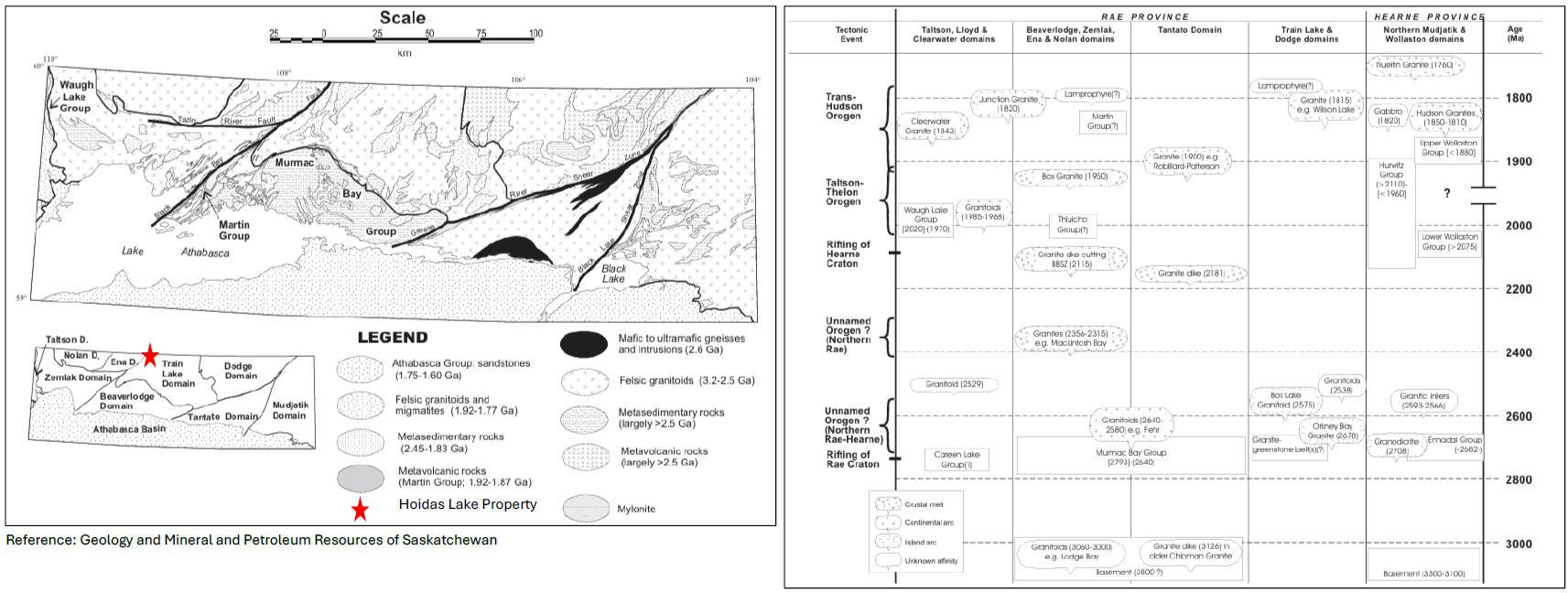
The Hoidas Lake Project is situated within the Western Craton of the Precambrian Canadian Shield and more specifically in the southern Rae Sub-Province of the western Churchill Province of the Canadian Precambrian Shield and north of Lake Athabasca in northwest Saskatchewan. The Project occurs within the eastern margin of the former Ena Domain, but is now included in the Zemlak Domain, being several kilometres west of the Black Bay Fault or Shear Zone, which marks the boundary between the Zemlak Domain to the west and the Train Lake Domain to the east. Figure 1.3 shows the simplified geology of the Rae Province (to the left) and litho-structural and stratigraphic sequence of the Rae province (to the right). Ages in square brackets are based on detrital zorcon study: round brackets denote igneous ages. BBSZ: Black Bay Shear Zone.
| Hoidas Lake Rare Earth Element Property | 18 | December 6, 2024 |
|
REalloys Inc. |
Figure
1.3
Property Location within the Precambrian Domains of Rae Province and Stratigraphy of Rae Province
| Hoidas Lake Rare Earth Element Property | 19 | December 6, 2024 |
|
REalloys Inc. |
The Zemlak Domain comprises mainly upper amphibolite facies tonalites, granodiorites, and leucogranites with lesser intermediate rocks, amphibolites, psammitic to pelitic gneisses and diatexites, and alkaline intrusive rocks. The Black Bay Fault is represented by a several kilometre-wide mylonite zone which extends westward from its trace along the Tazin River several kilometres east of Hoidas Lake. The Nisikkatch – Hoidas fault (mylonite zone) is probably a splay off the Black Bay Fault and passes through the area of interest. Younger brittle faults of several orientations offset the older mylonite zones.
Age dating of various rock types was undertaken by members of the Saskatchewan Geological Survey in the greater Beaverlodge region (50 km southwest of Project area and to the west of the Black Bay Fault). This age dating work provides a tentative time framework for geological events in the Hoidas Lake area. Age dating in the Zemlak Domain has shown the presence of Archean and Paleoproterozoic orthogneisses with metamorphic events corresponding to the 2.37 Ga Arrowsmith Orogen and the 1.93-1.9 Ga Taltson Orogen (Ashton, Hartlaub et al., 2009; Ashton et al., 2009).
Lamprophyre dykes, prevalent in the Nevins–Forsythe Lakes area of the Beaverlodge Domain (Harper, 1986) and bearing identical likeness to the lamprophyres of the Hoidas Lake area, provided a U-Pb titanite age of 1,780 Ma (Card, 2001). An alkali feldspar quartz syenitic dyke from the central Train Lake Domain is also considered to be part of the lamprophyre suite and provided a U-Pb titanite age of 1,788 ± 3 Ma (Ashton, Hartlaub et al., 2009). Both of these ages are believed to indicate the time of cooling of the lamprophyre/syenite.
Two samples of the JAK Zone REE mineralization have also been dated and provide very different results; however, the results are, as yet, inconclusive (Gunning and Card, 2005; Normand, 2010).
| 1.5.2 | Property/Local Geology |
The property is located approximately 4 km northwest of the Black Bay Fault. The Hoidas-Nisikkatch Fault parallels and is adjacent to the mineralized zone. Granitic rocks are the most abundant rock types in the area.
Geological mapping (Harper, 2012; Figure 1.4) identified two major rock units; a possible Archean tonalite gneiss complex and granitic gneisses, which are probably mainly Paleoproterozoic in age. Minor rock units include: migmatitic psammitic to psammo-pelitic and pelitic gneisses, amphibolites of intermediate to mafic composition, early and late dioritic rocks, syenite – quartz syenite, hyalophane-bearing pegmatites, unmineralized diopside-hyalophane veins/dykes, as well as REE mineralized varieties of them, and lamprophyre dykes representing the youngest intrusive event in the area. The last four rock units all have an alkaline magmatic affinity, and they generally show the least effects of regional deformation and metamorphism. Late brittle quartz veining and development of quartz-flooded breccias are probably the youngest rock forming events in the area.
The Tonalite Gneiss Complex comprises a variety of rock types ranging in composition from diorite to granite and varying in texture, colour and grain size. As a group, they are light to medium to dark grey, and more pinkish coloured where granitic veins and dykes become more prevalent and can be strongly reddened due to hematite and/or potassic alteration along late fractures or adjacent to major faults or shear zones.
| Hoidas Lake Rare Earth Element Property | 20 | December 6, 2024 |
|
REalloys Inc. |
Dioritic gneiss forms a number of small mappable bodies which may be part of the tonalite complex or possibly a border phase to some of the larger granitic bodies. These rocks are fine to medium to very coarse grained, grey to dark grey and well foliated with 30 to 50% mafic mineral content, with hornblende generally more abundant than biotite.
Supracarustal rocks include amphibolite and migmatitic metasedimentary gneisses. Amphibolite Gneiss occurs in several areas of the property both alone and associated with the migmatitic metasedimentary gneisses. The amphibolites are light grey to dark grey, dark green-grey to black depending on the hornblende content. In the area west of south-central Hoidas Lake, some of the amphibolite rocks have a brownish weathered surface, possibly suggesting the presence of hypersthene. The rocks tend to be medium grained, generally equigranular, but well foliated.
Figure
1.4
Property Geology (Harper 2012) Showing the Location of the JAK Zone and the Other Areas of Mineralization
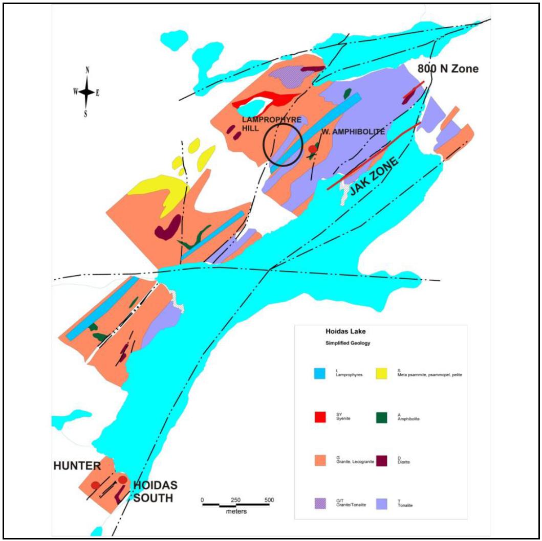
Figure taken from the 2014 Barr Technical Report.
| Hoidas Lake Rare Earth Element Property | 21 | December 6, 2024 |
|
REalloys Inc. |
Compositionally, they range from intermediate to mafic, which, together with a gross compositional banding and smaller scale layering, strongly suggests a supracrustal, i.e. volcanic, origin. The migmatitic metasedimentary gneisses comprise an interlayered sequence of mainly psammo-pelitic and psammitic rocks with minor pelitic gneiss. They occur along the northwest part of the grid. Anatexis of the psammo-pelitic and pelitic rocks is well advanced, such that the psammitic rocks are typically the only recognizable original component. The rocks are light to medium grey with white and pink coloured granitoid leucosomes. Grain size varies from fine grained in the psammitic remnants to pegmatitic in the leucosomes.
There are also a number of younger intrusive rocks cross-cutting the above, including granitic rocks, a syenite-quartz syenite suite, fine grained diorite dykes, hyalophane-bearing pegmatites, the diopside hyalophane plus REE suite of veins and dykes and the lamprophyre dykes.
Granitic rocks are the most abundant rock types in the area.
Pink leucogranite is also very prevalent in the areas underlain by the metasedimentary gneisses and might actually represent the roof of the pluton which, upon intruding the metasediments, produced a sheeted zone of alternating granite and metasediment.
The syenite – quartz syenite is best developed around the east end of the proposed tailings pond and along the edges of the channel leaving the east end of the pond. Extensive felsenmeer in the valley to the east is all part of the syenite suite. A second area of syenite felsenmeer occurs in the low ground adjacent to the southwest end of the U-shaped lake at the west end of the proposed tailings facility. These rocks are dark pink to red, relatively massive to weakly foliated, and, generally, coarse grained. The syenite proper also appears to contain up to 10% of a 3 to 5 mm diameter green mineral which is believed to be a pyroxene, although it is also commonly altered to a yellow green mineral resembling epidote. Strongly weathered outcrops and boulders show a pitted surface where these minerals have been preferentially altered to a powdery yellowish-orange material. The quartz syenite contains up to 20%, roundish, white quartz grains 2 to 4 mm in diameter and tends to lack the mafic mineral. This sub-unit seems to only occur near the margins of the syenite adjacent to the surrounding granites. Of potential interest to the REE story was the discovery of an angular slab of what appeared to be a syenite breccia found in the felsenmeer area east of the pond the texture of which was similar to the REE-bearing apatite breccias exposed in the large trench at the JAK Zone.
Late diorite dykes intrude all of the above rocks but were not seen within the syenite. They are typically fine grained, light to medium grey, straight walled, range from 5 cm to 15 m in width and commonly show chilled margins.
| 1.5.3 | Mineralization |
The Diopside-Hyalophane and REE dykes/veins are currently found in two main areas:
| 1) | A zone at the north end of Hoidas Lake, approximately 600 m wide (Southeast to Northwest) and at least 1,000 m long (Southwest to Northeast), which includes the JAK Zone. |
| 2) | A 300 m wide zone at the southwest end of Hoidas Lake which includes the Hoidas South showing. The latter zone was only examined over a minimum strike length of about 200 m, but there are other known occurrences located farther southwest along the Nisikkatch–Hoidas Shear Zone. |
| Hoidas Lake Rare Earth Element Property | 22 | December 6, 2024 |
|
REalloys Inc. |
The diopside-hyalophane veins are dark green with paler margins, green and white, and white with green depending on the relative abundance of the two major components. Many of these veins are found occupying slight to moderate linear depressions on the outcrop surface. The veins are typically very coarse grained with crystals reaching 10 to 20 cm in length or width, and non-radioactive with a background of approximately 40 counts per second (cps); however, the presence of even a small amount of allanite will more than double their radioactivity to greater than 100 cps. The diopside-rich veins/dykes have narrow margins of hyalophane, or isolated coarse crystals of hyalophane intergrown within the vein and vice versa for hyalophane-rich veins. A narrow alteration halo may also be developed along these veins.
The REE mineralized veins/dykes are distinguished by the addition of allanite and by various forms of apatite. Allanite can be intergrown with diopside and occurs also as massive veins. It can also be intergrown with apatite. The presence of allanite is commonly the main cause of the radioactivity which can reach several thousand counts per second. The apatite is typically coarse-grained which show textures that suggest they invaded the earlier diopside-rich zones, as indicated by veins cutting diopside, xenoliths or fragments of diopside within the apatite and by xenoliths of gneissic country rocks. The apatite phase commonly shows a breccia texture, which is best seen on weathered surfaces. Red apatite breccias, with minor green apatite, was the main variety found in the new showings around the Hoidas South and Hunter showings.
Hyalophane Pegmatites are found intruding all of the above rock types including the diopside-hyalophane veins, but there is also evidence to the contrary with diopside-hyalophane cutting hyalophane pegmatite. There are also some hyalophane-bearing pegmatites that contain the D2 deformational fabric, and it would appear that these pegmatites were possibly emplaced axial planar to tight to isoclinal F2 folds. Therefore, there is a significant range of ages of emplacement for these dykes. They range from a few centimetres to 1.5 m in width and have been traced for up to 10 m before disappearing under drift cover.
The JAK zone occurs within this series of vein sets. It outcrops along the northwest shore of Hoidas Lake and exhibits open rare earth mineralization down dip below the lake, to the north and south. Individual outcropped veins are up to 5 m wide and can occur as fairly isolated small single mineralogical composition veinlets through to large multi-zoned veins exhibiting hyalophane, diopside and allanite at the hanging wall and foot wall contacts with apatite and breccias at the centre. The rare earth elements are hosted predominantly by apatite and allanite with minor amounts of mineralization in chevkinite, monazite and rare earth-bearing carbonates.
| Hoidas Lake Rare Earth Element Property | 23 | December 6, 2024 |
|
REalloys Inc. |
The rocks record four major deformation events, the earliest of which, D1, is difficult to recognize; however, the S1 foliation that was developed was subsequently isoclinally folded during D2 and resulted in a strong composite S1-S2 foliation being formed. This S1-S2 fabric is the main foliation observed in the area and generally trends northwesterly, west of Hoidas Lake. Peak metamorphism occurred at this time and attained upper amphibolite facies conditions and possibly was transitional to granulite facies. The third deformation, D3, is related to shear zone development and reactivation along the long-lived Black Bay Fault. This produced a weak to strong northeasterly overprint fabric, S3, on all but the lamprophyres. The intensity of S3 depends on the proximity to the major shear zones. For example, the REE mineralized veins at the Hoidas South showing are strongly deformed (folded, stretched, boudinaged, foliated) as they occur within the zone affected by the D3 Nisikkatch – Hoidas Shear Zone, whereas the JAK Zone and many of the new showings are only mildly or not obviously affected. A fourth event, D4, is marked by open north trending folds which did not develop a foliation. Brittle reactivation of faults apparently continued for some time after.
The REE mineralized diopside-hyalophane-apatite-allanite veins/dykes are structurally controlled and occupy structures that clearly cross-cut the composite S1-S2 fabric. The principal veins strike 040° to 050° and dip moderately to steeply southeast. A system of riedel shears is developed between the principal veins and the orientation of the diopside-hyalophane-filled R shears at 060° to 070° indicates a dextral sense of shear. This is also supported by drag folding of the S1-S2 fabric into the mineralized structures. Connecting R’ shears were also recognized at high angle to the R shears. Both R and R’ shears can be mineralized; thus, creating three orientations that can be mineralized. The amphibolite-hosted REE veins appear to be related to a different set of structures; a set that is sub- parallel to a northerly trending fault and a conjugate set of fractures related to the northerly fault.
An attempt has been made to create a preliminary lithological model of JAK Zone based on the core-logging information available. Some of the litho-coding has been merged for the purpose of simplification of the lithological units appear at the property. The primary units are Diorite, Granodiorite, Granite and tonalite. All secondary units are treated as intrusive. A vertical cross-section (Figure 1.5) has been presented where the relation between different litho-units can be assessed. The superimposition of the intrusive unit (Mineralized REE veins) is also depicted in Figure 1.5.
| Hoidas Lake Rare Earth Element Property | 24 | December 6, 2024 |
|
REalloys Inc. |
Figure
1.5
Generalized Cross-Section of the JAK Zone Mineralization at the Hoidas Lake Project (looking Northeast)
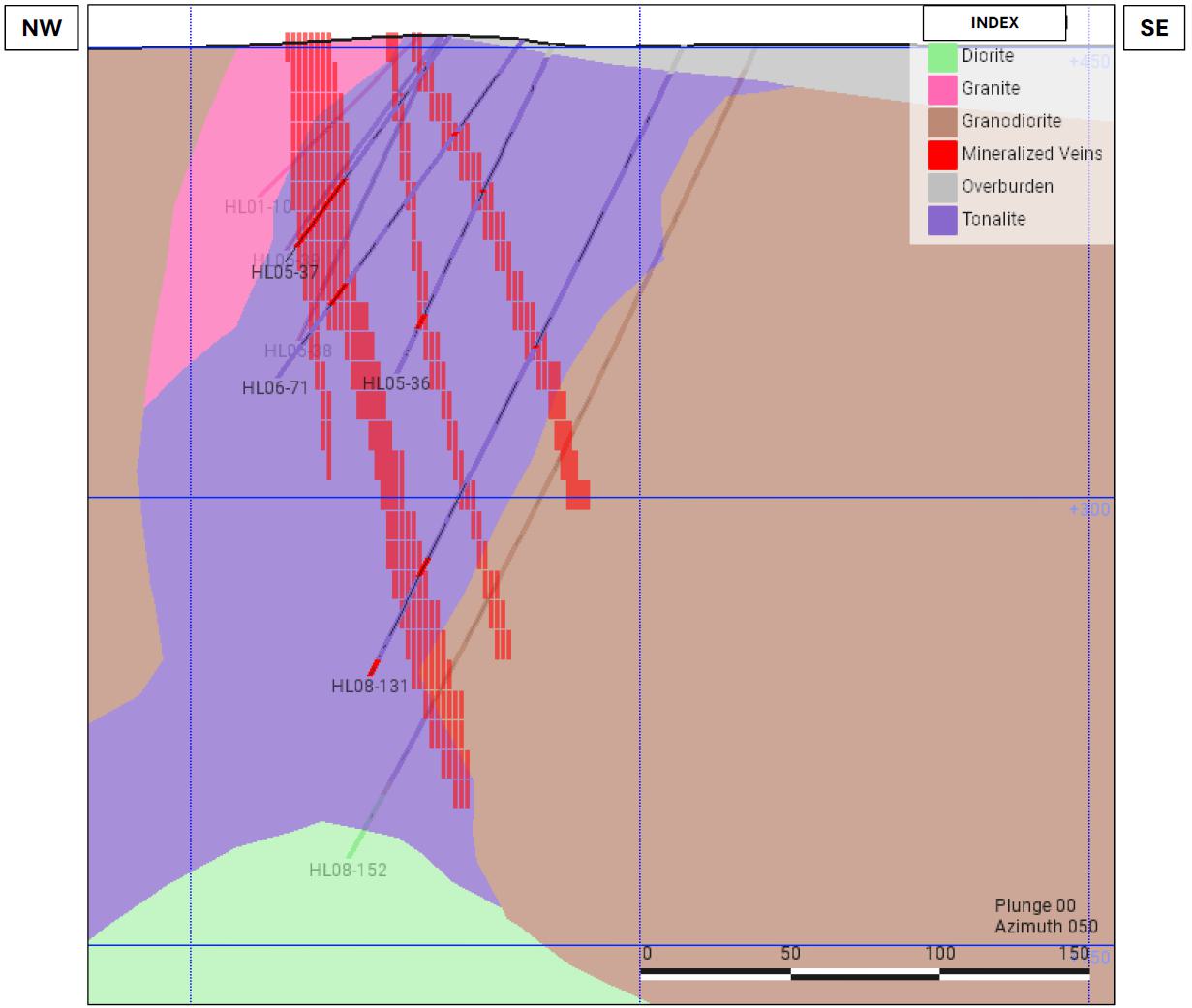
Generalized cross-section of the JAK Zone by Micon.
The reader should be aware that a full geological or lithological model has not been completed for the Hoidas Lake property and that this will need to be addressed as the Project advances.
| 1.5.4 | Deposit Type |
The origin of the mineralization has been described as having alkaline magmatic and hydrothermal components (Hogarth, 1957; Gunning and Card, 2005; Halpin, 2010). The overall abundance of barium in the rock system in the Hoidas Lake area supports the alkaline affinity, as does the presence of syenites and lamprophyres. The hyalophane-bearing pegmatites are recognized as having a wide range of emplacement ages from syn- to late-D2 (ca. 1970 to 1940 Ma) to post diopside-hyalophane-REE mineralization of syn- to late-D3, thus indicating a prolonged period of alkaline magmatism and hydrothermal activity.
| Hoidas Lake Rare Earth Element Property | 25 | December 6, 2024 |
|
REalloys Inc. |
Recognition of a dextral riedel shear system for the structural context of some of the REE mineralization is also an important factor in determining future drill programs and knowing that mineralized zones can occur in several related directions. One model for the origin of the REE mineralization has the alkaline magma and associated fluids being emplaced along the Nisikkatch –Hoidas Shear Zone and its associated sub-parallel structures (Figure 1.7). Dextral shear active along these structures produces dextral riedel shear systems, as in the JAK Zone and the new showings at L7+50N.
Figure
1.6
Model for the Origin of the REE Mineralization in the Hoidas Lake Area, Showing an Alkaline Magma Source at Depth
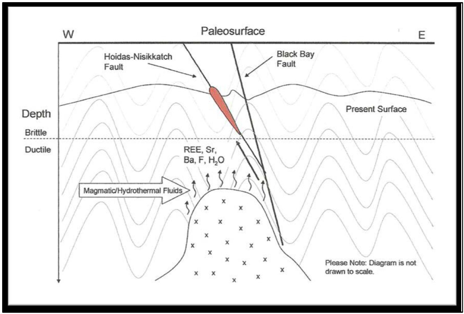
Modified from Halpin (2010) and extracted from the 2014 Bar Technical Report.
| 1.6 | Exploration |
| 1.6.1 | REalloys Exploration |
In September, 2024 REalloys completed an airborne magnetics and radiometric survey totalling 1,375 line-km. The work was undertaken by Axiom Geophysics and Remote Sensing (Axiom). However, at the time of this Technical Report, no final report has been completed, although the daily reports have been reviewed by Micon.
| Hoidas Lake Rare Earth Element Property | 26 | December 6, 2024 |
|
REalloys Inc. |
| 1.6.2 | REalloys Drilling |
Realloys has not conducted any drilling programs on the property.
| 1.7 | Sample Preparation, Assaying and Analytical Procedures |
| 1.7.1 | Historical Sampling |
The sampling procedures were established by a Sampling Procedure Protocol developed in 2005 by Great Western Minerals and followed by all subsequent drilling and sampling programs. The 2001 drilling program did not have a sampling protocol.
| 1.7.2 | Sample Preparation |
| 1.7.2.1 | 2001 Sample Methodology |
In the 2001 drilling program, the mineralized sections were identified by the geologist in charge of the program (I. Young). The samples were marked out by the geologist and sampled under his supervision. Samples were selected based on visual examination of the drill core. In most cases, there were no samples taken from the hanging wall and foot wall of the mineralized sections. This was done in subsequent years to define assay boundaries to the mineralized sections. The samples were split with a core splitter, with one half returned to the core box and the other half placed into a polyethylene bag. A sample tag was placed in the bag, with the bag sealed, placed in a sample pail while the samples were shipped via air to Saskatoon, where they were analyzed at the SRC Geoanalytical laboratory. One sample tag was retained, and these books were stored at the Great Western Minerals office in Saskatoon.
| 1.7.2.2 | 2005 to 2008 Sample Methodology |
Samples from the subsequent drilling programs in 2005, 2006 and 2008 followed the Great Western Minerals sampling protocol. Following this Protocol, sections exhibiting mineralization or alteration were selected by Great Western Minerals geologists at the Hoidas Lake site. The sample lengths were required to be no longer than 2 m and no shorter than 0.5 m, except in exceptional circumstances, and the geologists used their best judgment to make this decision. The samples were marked by pencil or crayon on the core and core box.
When the veins being sampled exceeded 2 m in core length, at least 1 metre of hanging-wall lithology and 1 metre of foot-wall lithology were required to be sampled in order to define assay boundaries of the vein. Areas of barren rock within the vein were required to be sampled to identify internal dilution. Sample intervals were tagged and numbered at corresponding sample boundaries and placed in core boxes with aluminum tags.
The core was split or sawed and then placed in a polyethylene bag. Sample tags were placed in the polyethylene bag with the core, in the corresponding core box at the beginning of the sample interval, and in a sample book for future reference. The polyethylene bag was then sealed with a plastic tie, placed in a plastic bucket and sealed with a lid which included a tab that was only to be removed at the laboratory. The other half of the core remained in the core box. The sample tag number, drill hole number, interval, and location were recorded in a sample tag book, the corresponding drill log, and the geologist’s field book.
| Hoidas Lake Rare Earth Element Property | 27 | December 6, 2024 |
|
REalloys Inc. |
Blank Sample
Blank samples were collected from a cliff face exhibiting barren rock, at Oshowy Lake, which is approximately 5 km to the north of the Hoidas Lake property.
Field Duplicates
Field duplicates were collected by taking two quarters of the selected sample interval and placing each in a polyethylene bag with sample tags that were sequential with the other samples in that group. The remaining half of core was placed back in the core box just as the other samples.
Standard Samples
Two standard samples were used by Great Western Minerals. A high-grade rare earth thorium ore (OKA 2) and a low-grade diorite gneiss (SY 4), both of which were obtained from Canada Centre for Mineral and Energy Technology (CANMET) Mining and Mineral Science Laboratories in Ottawa, Ontario. CANMET is a Canadian Certified Reference Materials Laboratory which sells Certified Standards to the mineral industry.
Great Western Minerals Protocol for Blanks and Field Duplicates
For every group of thirty samples, a blank sample was placed as the fourth sample, every seventeenth sample was a field duplicate, and every twenty ninth sample was a standard. Continuous numbering was used for each group.
Sample Logistics for the Exploration Programs
The samples were shipped via airplane to Stony Rapids and then via truck to the SRC in Saskatoon.
A daily checklist was prepared and required to be completed by the onsite geologist to verify procedures had been followed. Mr. John Pearson reviewed sampling procedures at least once during each sampling program.
| 1.7.2.3 | Micon QP Comments |
Micon has reviewed the historical sampling procedures
| Hoidas Lake Rare Earth Element Property | 28 | December 6, 2024 |
|
REalloys Inc. |
| 1.7.2.4 | Sample Analysis |
Sample analysis was performed by SRC in Saskatoon.
Sample preparation consisted of the samples being dried in the original plastic bags at 80 degrees C overnight, jaw crushed to 60% passing 2 mm and then split out to 100 g to 200 g subsample using a riffle splitter.
The subsample was then pulverized to a 90% 106-micron pulp using a grinding mill. The grinding mills were cleaned at least once between every sample, and silica sand cleaning was employed between groups. The pulp was transferred to a labeled plastic snap-top vial.
The assay procedure required an aliquot of the pulp being combined with 1000 mg of lithium metaborate flux and fused in a graphite crucible in a muffle oven at 1000 degrees C for one hour. After fusion, the resulting bead was crushed to a fine powder using a mortar and pestle. The powder was transferred to a beaker with 60 ml of deionized water and 6 ml of nitric acid and stirred until completely dissolved. The solution was then made up to 100 ml and analyzed by ICP-OES.
The instruments used for ICP-OES analysis were PerkinElmer Optima 300DV, Optima 4300DV or Optima 5300DV and were calibrated using certified commercial solutions. The detection limit for rare earth elements analyzed was 0.002%.
A control sample was prepared and analyzed with each batch of samples. One out of every 40 samples was analyzed in duplicate. Corrective action was taken when results exceeded specific limits. Quality control measures and data verification procedures that were applied also included the preparation and analysis of three standards and one blank where the blank was flux only.
SRC Geoanalytical is a provincial/commercial laboratory which was independent of Great Western Minerals. It began operating in 1972 and currently has a quality management system that operates in accordance with ISO/IEC 17025:2005 (CAN-P-4E), General Requirements for the Competence of Mineral Testing and Calibration laboratories and is also compliant to CAN-P-1579, Guidelines for Mineral Analysis Testing Laboratories. The management system and selected methods are accredited by the Standards Council of Canada (Scope of accreditation # 537).
It is Micon’s opinion that SRC Geoanalytical is adequate for the sample preparation, security, and analysis of the samples used for as the basis of the historical and current mineral resource estimates. Micon’s QP notes that SRC Geoanalytical continues to be a provincial/commercial laboratory, and it is independent of the current property owners REalloys as well.
| 1.8 | Data verification |
| 1.8.1 | General Information |
Data verification by Micon consisted of several steps, as follows:
| ● | The Hoidas Lake database and block model were obtained from Barr Engineering and were reviewed for completeness, accuracy of the data and suitability for use as the basis for an updated mineral resource estimate. |
| Hoidas Lake Rare Earth Element Property | 29 | December 6, 2024 |
|
REalloys Inc. |
| ● | Mineralization was examined in the trenches and in the core to verify the mineralization located on the property. |
| ● | Core Racks were inspected during the site visit, to see if the core could still be used for the purposes of relogging and verification of the mineralization against the current database. |
Several discussions were held with Barr Engineering and REalloys personnel or contractors to discuss the project, the economic parameters to be used during the resource estimate update and the modelling process itself.
Further discussions were held with REalloys personnel or contractors throughout the process of reviewing and validating the mineral resource estimate and completing the Technical Report.
| 1.8.2 | 2024 Site Visit |
Micon undertook a site visit from August 19, 2024, to August 21, 2024, with August 20, 2024 spent on site at Hoidas Lake. During the site visit, several trenches were visited and the core racks on site were inspected.
Discussions were held while on site, and throughout the site visit, regarding the nature and trend of the mineralization and deposit, further work to be conducted on the property, access to the property, QA/QC programs, further verification of previous drill samples, further surface sampling and mapping, as well as other exploration related programs.
| 1.8.3 | Micon Comments |
In general, Micon believes that the old camp, dock and core racks are in good condition for their age. However, both the camp and the dock will likely need to be repaired and updated before new work programs can begin at the Project. As further exploration is conducted at the Project it may be a good time to relocate the camp and core racks to a more permanent location, so that they do not need to be moved several times as the Hoidas Lake Project advances along the study path towards a production decision.
Micon has viewed the existing Hoidas Lake database from Barr Engineering and finds that, while improvements can be made to the overall modelling of the deposit in future iterations, the database is sufficient as the basis for the updated 2024 resource and future mineral resource estimates.
| 1.9 | Mineral Processing and Metallurgical Testing |
The Hoidas Lake property includes both rare earth elements (REE) and phosphorus (apatite) mineralization. The rare earth metals at the Hoidas Lake property are primarily found in the bastnasite and allanite minerals and, secondly, in the monazite, parasite, thorite and apatite minerals.
Testwork related to mineral processing and extractive metallurgy using composite samples representing the mineralization at the Hoidas Lake deposit was initiated in 2001 and continued into 2012. A number of programs have been completed using well known independent test laboratories located in Canada, USA and China. Initial work was mainly undertaken as SGS Mineral Services at Lakefield, Ontario, Canada (SGS-Lakefield) and The Center for Advanced Mineral & Metallurgical Processing (CAMP) at Montana University, USA, while later development work was undertaken at the Guangzhou Research Institute of Non-ferrous Metals (GZRINM), a research and development institute based in China that specializes in the processing of rare earths and rare metals.
| Hoidas Lake Rare Earth Element Property | 30 | December 6, 2024 |
|
REalloys Inc. |
The most recent study was completed by a Chinese technical institute in 2012 and indicated that it is technically feasible to recover a rare earth concentrate in the form of a mixed RE carbonate and phosphorus as a Nitrogen-Phosphorus or NP-fertilizer. The process developed comprises flotation and magnetic separation to produce a rare earth concentrate and an apatite concentrate. These concentrates are then treated separately, using conventional hydrometallurgical technologies to extract rare earths and phosphorus. Table 1.4 provides a summary of results for the combined beneficiation and extractive metallurgical process. The overall RE recovery is 70% and phosphorus recovery is 93%.
Additional testwork is recommended to first confirm then optimize the process flowsheet developed so far. The work should focus on the best technical and economic process solution for the Hoidas Lake Project.
Once the best techno-economic process has been selected, a variability test program should be undertaken to improve the geo-metallurgical understanding of the deposit.
Table
1.4
Summary of Results of the Combined Beneficiation and Extractive Metallurgical Process
| Description | RE (TREO) | Phosphorus (P2O5) | |||
| Grade
(%) |
Distribution
(%) |
Grade (%) |
Distribution
(%) | ||
| Feed sample | 2.72 | 100.00 | 12.50 | 100.00 | |
| Beneficiation | Rare Earth (RE) concentrate | 9.27 | 49.20 | 2.93 | 3.26 |
| Apatite concentrate | 2.78 | 40.25 | 31.29 | 94.95 | |
| Metallurgy | RE carbonate produced from RE conc. | 60.39 | 78.62 | - | - |
| RE carbonate from apatite conc. | 60.13 | 78.64 | - | - | |
| NP fertilizer from apatite conc. | - | - | 15.74 | 97.44 | |
| Combined beneficiation-metallurgy process | - | 70.33 | - | 92.52 | |
| 1.10 | Hoidas Lake Mineral Resource Estimate |
| 1.10.1 | Introduction |
Barr supplied the electronic resource database for the Project to Micon, as Barr had previously undertaken the mineral resource estimate in 2009 for the Hoidas Lake Project. Micon reviewed and has accepted most of the estimation work conducted by Barr; however, Micon used its own judgement for mineral resource categorization and economic parameter assumptions and used an NSR approach to report the mineral resource statement for this report.
| Hoidas Lake Rare Earth Element Property | 31 | December 6, 2024 |
|
REalloys Inc. |
This section describes the development of the resource estimate, including methods used and key assumptions considered during the estimation process.
This section will also use the terms diluted and undiluted material in the context of mineral resource estimates. The terms “diluted” and “undiluted” material refer to the way the “mineralized material” and “waste” are accounted for when modelling mineable volumes within Mineable Shape Optimizer (MSO) shapes are currently used in computer generated mineral resource estimates.
| ● | Undiluted Material refers to only the blocks of mineralized material in the model that are above the cut-off grade within the MSO. This excludes the surrounding waste or marginal material. This results in a shape that represents the ideal geological limit of the mineralization. This material does not factor any material that is unintentionally mined along with the mineralized material, such as internal waste bands or wall rock, due to the practical limitations of the mining equipment or methods. |
| ● | Diluted Material refers the same blocks of mineralized material but including additional material (usually lower grade or waste) that will inevitably be collected during the actual mining. Dilution accounts for both the internal waste within the MSO shape as well as waste that is mixed from the outside edges of the mineralized material (external dilution). The blending of the dilution and the mineralized material in the MSO shapes results in higher tonnages and a lower grade overall for the mined material but reflects the realistic view of what will be sent to the processing facility (mill). |
While reporting both the diluted and undiluted values is common with the diluted tonnage grades usually lower than the undiluted tonnage grade, it is the diluted figures that are more representative of the mineralized material which will be mined and processed. Therefore, the best practice when reporting mineral resource estimates is reporting the diluted tonnages and grades within an MSO shape.
| 1.10.2 | Mineral Resource Supporting Data and Block Model |
| 1.10.2.1 | Database |
Upon receipt of the previous mineral resource database from Barr, Micon conducted a thorough review of the documentation to ensure that the geological database was sufficient to support a mineral resource estimate. Micon’s review found no significant errors in the database and Micon concluded that it was acceptable to be used as the basis for this mineral resource update on the Hoidas Lake deposit.
A total of 188 drill holes were contained in the geological database, but only 110 drill holes occurred in the area of the Hoidas Lake deposit and those were used in the estimation of the mineral resource. Figure 1.8 shows the existing drill hole location plan for Hoidas Lake.
The only significant change to the database was that Barr provided Micon with the geological database and block model in a non-rotated local grid coordinate system, which is typical practice in many exploration projects. However, Micon undertook the transformation of the database local grid drill holes and block model into a UTM, datum NAD83 Zone 13N coordinate system, to represent the true geographical location of the Hoidas Lake mineral deposit.
| Hoidas Lake Rare Earth Element Property | 32 | December 6, 2024 |
|
REalloys Inc. |
Figure
1.7
Hoidas Lake Drill Hole Location Map
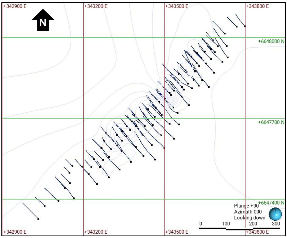
Figure dated November, 2024.
| 1.10.2.2 | Topography |
No topographic surface was provided for the Hoidas Lake Project. As the local terrain is relatively flat and the current mineral resource is based upon an underground longhole mining method, Micon proceeded to construct a new topographic surface from drill hole collar elevations.
| 1.10.2.3 | Rock Density |
The density value was provided in the block model as a single average value of 3.11 g/cc.
| 1.10.2.4 | Compositing |
The original composites for the previous Barr resource estimate were not provided to Micon. For compositing purposes, Micon recreated a set of 1 m equal length composites from the drill holes, following the block model mineralization limits and attributes for the nearest sample distance.
| Hoidas Lake Rare Earth Element Property | 33 | December 6, 2024 |
|
REalloys Inc. |
| 1.10.2.5 | Variography |
The spatial variability for a given element depends on both the separation distance between sample points and the direction for point to point. Therefore, the spatial variability increases, and the correlation decreases with the separation distance and variograms measure this variability. Barr constructed variograms using composites within the JAK Zone for each element following the strike and intersecting the dip of the deposit. However, Barr found the data was not sufficient to pick up any substantial structure down dip. Barr inferred that the best structures were found along the strike (north-south) where most graphs reached a sill at approximately 30 metres. Barr considered this direction to be representative of the spatial continuity of the Hoidas Lake deposit and therefore the variograms were assumed to be isotropic. Barr then used the inverse distance cubed (ID3) method to populate the blocks within the model. Micon reviewed Barr’s work and continued to use the ID3 method as well.
| 1.10.2.6 | Block Model |
The original model was a non-rotated percent block model located in a local grid, using a block size of 2.0 m across strike by 2.5 m along strike with a 10 m height, a variable percentage (ZPERT) was used to better represent the mineralized and unmineralized volumes.
Micon proceeded to transform the blocks into the UTM NAD83 Zone 13N coordinate system, with a rotation of 49.5 degrees clockwise to situate the model into the correct geographical coordinates but otherwise used the same block model attributes as Barr.
| 1.10.2.7 | Block Model Validation |
The block model was validated against the supporting data using three methods: visual inspections, global statistical comparison and swath plots. Figures 1.9, 1.10 and Table 1.5 show the results of the validation.
In Table 1.5 the global statistical average comparison of the input composites grades versus output data indicates that the block grades are reasonable, ranging from -3 to 6% in the economically relevant elements like Nd, Ce and La.
| Hoidas Lake Rare Earth Element Property | 34 | December 6, 2024 |
|
REalloys Inc. |
Figure
1.8
Hoidas Lake Project, Block Model Neodymium Visual Inspections in Sections Looking Northeast
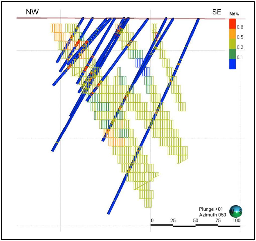
Figure dated November, 2024.
Table
1.5
Hoidas Lake Project, Block Model Global Statistical Comparison
| Element | Count | 1 m Comps Mean % | Block Count | Block Model Mean % | Difference (%) |
| Ce | 1,640 | 0.712 | 68,843 | 0.747 | 5% |
| Dy | 1,640 | 0.006 | 68,843 | 0.006 | 8% |
| Er | 1,640 | 0.004 | 68,843 | 0.004 | 15% |
| Eu | 1,640 | 0.009 | 68,843 | 0.010 | 2% |
| Gd | 1,640 | 0.021 | 68,843 | 0.023 | 10% |
| Ho | 1,640 | 0.000 | 68,843 | 0.000 | -2% |
| La | 1,640 | 0.322 | 68,843 | 0.341 | 6% |
| Nd | 1,640 | 0.354 | 68,843 | 0.343 | -3% |
| Pr | 1,640 | 0.090 | 68,843 | 0.096 | 6% |
| Sm | 1,640 | 0.047 | 68,843 | 0.050 | 6% |
| Tb | 1,640 | 0.002 | 68,843 | 0.002 | 5% |
| Tm | 1,640 | 0.000 | 68,843 | 0.000 | -17% |
| Y | 1,640 | 0.019 | 68,843 | 0.020 | 9% |
| Hoidas Lake Rare Earth Element Property | 35 | December 6, 2024 |
|
REalloys Inc. |
Figure
1.9
Hoidas Lake Project, Block Model 10 m Swath Plot for Neodymium
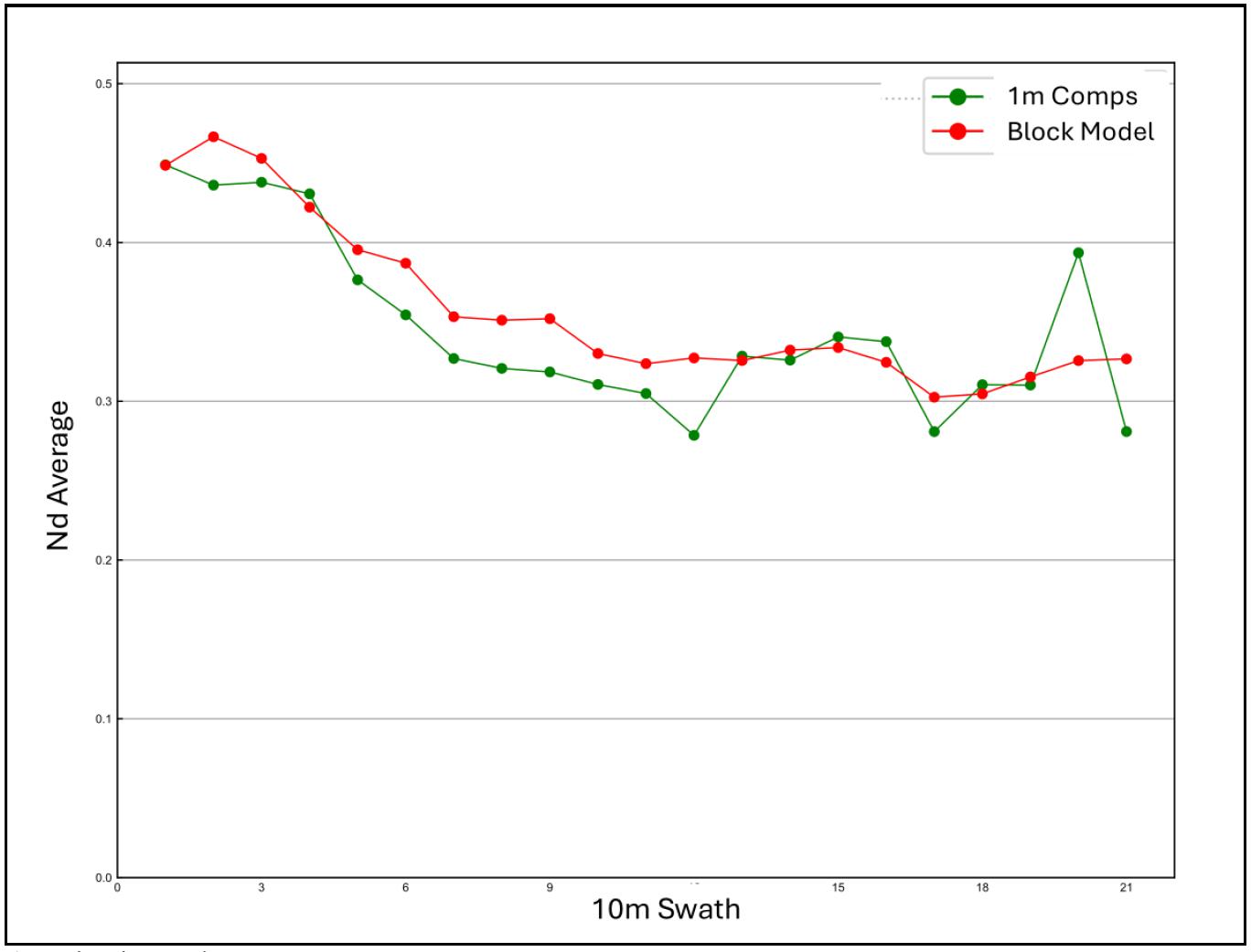
Figure dated November, 2024.
| 1.10.3 | Mineral Resource Estimate |
| 1.10.3.1 | Reasonable Prospects for Eventual Economic Extraction |
An estimated mineral resource must have reasonable prospects for eventual economic extraction (RPEEE). To assess the economic value of the Hoidas Lake Deposit, Micon adopted an NSR approach, with the bulk of the economic value at Hoidas Lake focused on the Light Rare Earth Elements (LREEs). Micon added Uranium and Thorium to the block model, but the elements were not included in the resource estimation because they are both considered deleterious elements, the effects of which need to be mitigated during any potential mining process. Table 1.6 summarizes the economic parameters used for the NSR calculation.
| Hoidas Lake Rare Earth Element Property | 36 | December 6, 2024 |
|
REalloys Inc. |
Table
1.6
Economic Assumptions for the NSR Calculation
| Pricing and Costs | Description | Units | Value* | Comments |
| Rare Earth Oxide Pricing | Lanthanum oxide (La2O3) | US$/kg | 1.25 | Oxide factor = 1.173 (20.44% REO) |
| Cerium oxide (CeO2) | US$/kg | 1.03 | Oxide factor = 1.228 (46.62% REO) | |
| Praseodymium oxide (Pr6O11) | US$/kg | 95.00 | Oxide factor = 1.208 (5.97% REO) | |
| Neodymium oxide (Nd2O3) | US$/kg | 95.00 | Oxide factor = 1.166 (20.57% REO) | |
| Samarium oxide (Sm2O3) | US$/kg | 2.14 | Oxide factor = 1.160 (2.71% REO) | |
| Europium oxide (Eu2O3) | US$/kg | 27.82 | Oxide factor = 1.158 (0.54% REO) | |
| Gadolinium oxide (Gd2O3) | US$/kg | 25.82 | Oxide factor = 1.153 (1.24% REO) | |
| Terbium oxide (Tb4O7) | US$/kg | 1,500.00 | Oxide factor = 1.176 (0.11% REO) | |
| Dysprosium oxide (Dy2O3) | US$/kg | 375.00 | Oxide factor = 1.148 (0.35% REO) | |
| Holmium oxide (Ho2O3) | US$/kg | 74.61 | Oxide factor = 1.146 (0.00% REO) | |
| Erbium oxide (Er2O3) | US$/kg | 44.15 | Oxide factor = 1.144 (0.24% REO) | |
| Thulium (Tm2O3) | US$/kg | 114.98 | Oxide factor = 1.142 (0.00% REO) | |
| Ytterbium oxide (Yb2O3) | US$/kg | 14.27 | Oxide factor = 1.139 (0.05% REO) | |
| Lutetium oxide (Lu2O3) | US$/kg | 770.32 | Oxide factor = 1.137 (0.00% REO) | |
| Yttrium oxide (Y2O3) | US$/kg | 5.99 | Oxide factor = 1.270 (1.17% REO) | |
| Operating Costs, Metallurgical Recovery and Grade, Royalties | Underground Mining | US$/t | 70.0 | Assuming a long hole mining method |
| Beneficiation plant | US$/t | 25.0 | ||
| Hydrometallurgical plant | US$/t | 166.67 | ||
| General and Administration (G&A) | US$/t | 66.67 | ||
| Metallurgical Recovery | % | 70.0 | Based on GRINM Testwork Jan. 2009 | |
| Conc. Transportation | US$/t | 250.0 | Assumed to be dry concentrate. | |
| TREO Conc. Grade | % | 65.0 | ||
| Dubnick Royalty | % | 1.8 | From NSR, CA$1M max. over the LOM. |
| * | Note: REE value pricing for La, Pr, Nd, Tb and Dy taken from the 2024 Ashram REE Deposit Report and the other REEs value pricing are based on the information from the Ginger International Trade & Investment Pte., Ltd. website https://giti.sg/ in October, 2024. Micon’s QP believes that the REO pricing assumptions are reasonable and applicable over a longer term outlook for the next 5 years. |
The Oxide Factor is amount of elemental metal of the Rare Earth Element that is contained in the Rare Earth Oxide. For example, Table 1.7 the Dysprosium Oxide factor calculation.
Table
1.7
Dysprosium Oxide Factor Calculation
| Description | Molar Formula | Molar
Mass / Molecular Weight (g/mol) |
Content (%) | Oxide Factor |
| Dysprosium | Dy | 162.5 | 100.00% | |
| Oxygen | O | 15.999 | ||
| Dysprosium oxide | Dy2O3 | 372.997 | 87.13% | 1.1477 |
| Hoidas Lake Rare Earth Element Property | 37 | December 6, 2024 |
|
REalloys Inc. |
Dysprosium Oxide is 2 X the molecular weight of Dysprosium plus 3 X the molecular weight of Oxygen. Therefore, the Dysprosium metal contained in Dysprosium Oxide is 87.13% of the molecular weight of the oxide material or the molecular weight Dysprosium Oxide divided by an oxide factor of 1.1477.
The block model contains the original Rare Earth Element assays in metallic form. The oxide factor is used to convert the original REE metal assays into an oxide which is then used in the NSR calculation. This is because REE pricing is quoted in oxide not metal formats.
For example, the dysprosium original metallic assay value is multiplied by 1.1477 so the oxide form is Dy2O3 (87% of that is pure Dy) and then that’s multiplied by the price and the recovery.
The NSR calculation formula is:

Where:
x is Grade of each metal.
r is Metallurgical recovery of each metal.
R is Refining cost of each metal.
p is Smelting recovery of each metal.
V is Market price value of each metal.
K is Metric tonnes of ore required to produce one metric tonne of concentrate.
Cs is Smelter cost per tonne of concentrate.
Ct is Transportation cost per tonne of concentrate.
Once all the economic assumptions were processed, NSR value per block was calculated and attributed to the entire block model.
As the original mineralization wireframes were not available, and to account for mining dilution, Micon used the ZPERT attribute multiplied by the density of 3.11g/cc to correct the tonnage, then all mining shape stopes were assigned an expected dilution based on their mining width as follows:
| ● | Stopes from 3 m to 10 m wide, 25% dilution at zero grade. |
| ● | Stopes from 10 m to 20 m wide, 15% dilution at zero grade. |
| ● | Stopes greater than 20 m wide, 10% dilution at zero grade. |
The application of a dilution percentage to the various stope widths resulted in an average global dilution of 22%, which was then was applied to the undiluted tonnes for the mineral resource statement.
| Hoidas Lake Rare Earth Element Property | 38 | December 6, 2024 |
|
REalloys Inc. |
| 1.10.3.2 | Mineral Resource Classification |
General Discussion
Mineral resources have been classified as Measured, Indicated or Inferred in accordance with SEC Regulation S-K 1300. The classification is based on the level of geological knowledge and continuity, data quality (assay, survey, logging), and drill hole spacing, as determined by the Qualified Person.
| ● | Measured Mineral Resource: Reflects a high level of geological understanding and continuity, supported by closely spaced drilling (often less than 15 m), high assay confidence, reliable survey data, and demonstrable continuity confirmed in multiple sections. Areas must demonstrate low variability in grade and geology for the mineralization. |
| ● | Indicated Mineral Resource: Areas where evidence is sufficient to confirm continuity with reasonable certainty, typically drilled on a nominal spacing of 15 m to 30 m. Geological continuity is established but confidence is less than for Measured, with some local variability. |
| ● | Inferred Mineral Resource: Zones of mineralization where evidence and sampling are limited or wider spaced (typically 30 to 60 m or more between holes). Grade and continuity can be reasonably assumed based on geological and geostatistical interpretation, but with higher uncertainty. |
While mineral resource classification can be assigned primarily based on drill hole spacing, sample quality, and the degree of geological continuity the QP must also review the output of the computer generated classification to ensure there is no “Spotted Dog” effect occurs with the classified material to ensure that the measured and indicated resources are estimated with sufficient confidence to allow for the application of Modifying Factors to support the conversion of measured and indicated on to proven and probable reserves. Modifying Factors may include, but are not limited to, mining processing, metallurgical, infrastructure, economic, marketing, legal, environmental, social and governmental factors.
Hoidas Lake Mineral Resource Classification
Barr originally based its resource classification by using the distance to the nearest sample, together with number of drill holes and number of sample composites within a drill hole. All the samples considered within an interpolation search are within the JAK Zone. Barr summarized this as follows: “for a block to be classified as Measured, at least two samples from at least two holes within less than 12 metres (40% of the variogram range) from the closest sample were required. Indicated required at least two samples from at least two holes within a search distance greater than 12 metres and at least lower than or equal to 30 metres. Inferred was classified as all the material searched over 30 metres with at least one composite per hole.” Figure 1.11 is a long section showing the original resource classification based upon Barr’s definitions for measured, indicated and inferred mineral resources.
| Hoidas Lake Rare Earth Element Property | 39 | December 6, 2024 |
|
REalloys Inc. |
Micon generally agrees with Barr’s method but undertook a secondary visual assessment to eliminate the “Spotted Dog” effect that the original classification displayed which resulted from the computer using the distance to the nearest sample together with number of drill holes and number of sample composites within a drill hole to generate classification. Eliminating the “Spotted Dog” effect for classification in mineral resource is somewhat subjective as it is based upon the experience of the Qualified Person undertaking or auditing the mineral resource. The Qualified Person’s objective in eliminating the “Spotted Dog” effect is to be able to form continuous areas or larger areas of mineral resources that can support the use of modifying factors by mining engineers when they are scheduling potential production scenarios.
During its review and audit Micon noted that a portion of closer spaced shallow drilling towards the north formed a zone of somewhat continuous area of measured material and Micon’s QP decided this area would form the basis of the reclassified measured material for the deposit. The measured area is surrounded by a somewhat continuous zone of shallow close spaced indicated material while the drilling at depth and towards the south with more widely isolated pockets of measured, indicated and inferred material according to Barr’s methodology has been reclassified as inferred. The inferred material has the premise of continuity but no direct demonstration of continuity as with the areas reclassified by Micon as measured and indicated. Micon believes that the reclassified measured and indicated mineralization categories are sufficiently supported to apply modifying factors and are sufficiently supported to ensure consistency with the Committee for Mineral Reserves International Reporting Standards (CRIRSCO) aligned definitions.
Figure 1.12 is a long section of the Hoidas Lake Project showing the resource classification as determined by Micon.
Figure
1.10
Long Section showing the Original Barr Mineral Resource Categorization (Looking Southeast)
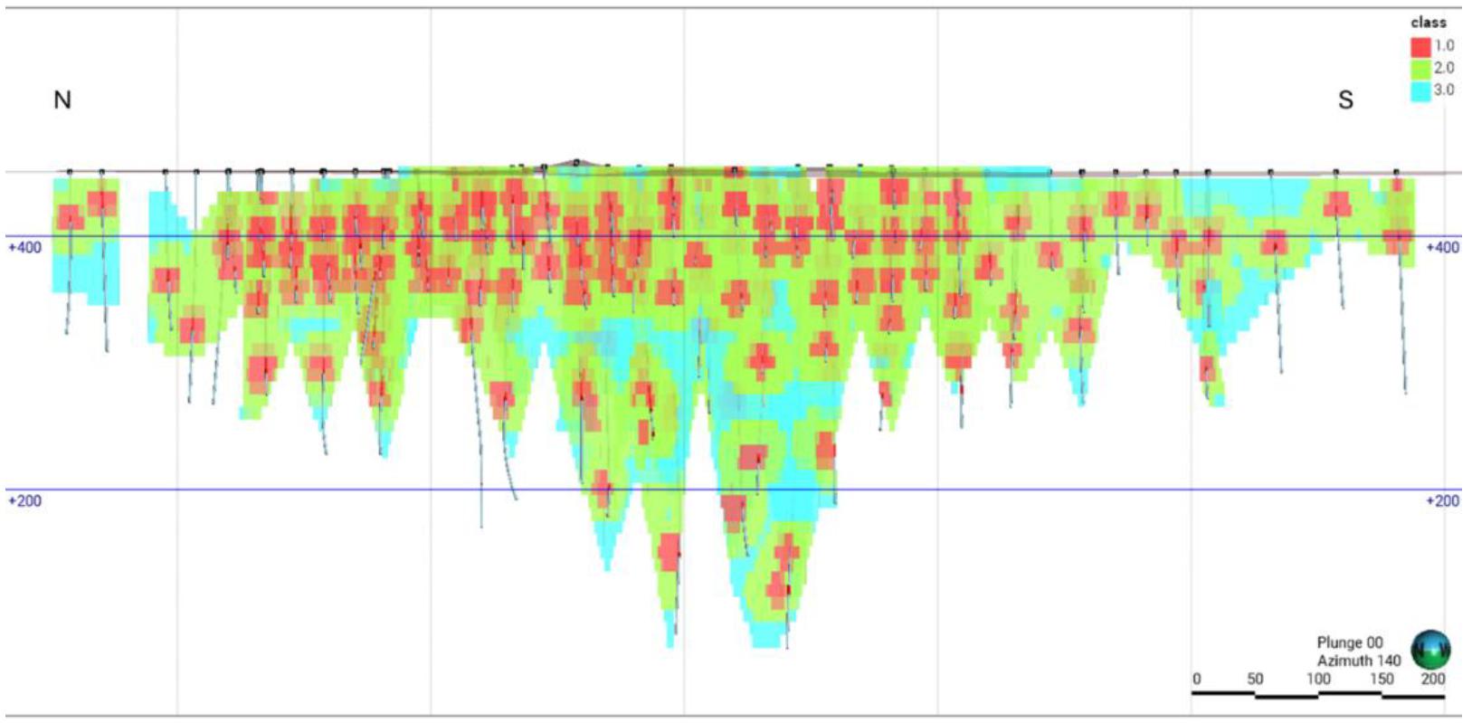
Note: Classification Legend: 1 = Measured, 2 = Indicated and 3 =Inferred. Micon Figure dated November, 2024.
| Hoidas Lake Rare Earth Element Property | 40 | December 6, 2024 |
|
REalloys Inc. |
Figure
1.11
Long Section showing the Micon Mineral Resource Categorization (Looking Southeast)
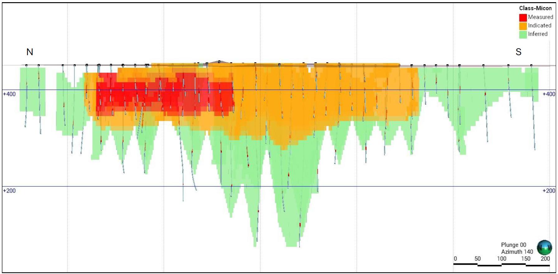
Micon Figure dated November, 2024.
| 1.10.3.3 | Mineral Resource Estimate |
The mineral resource estimate for the Hoidas Lake Project is summarized in Table 1.8, with a more detailed summary for the various elements in Table 1.9. The mineral resource estimate was determined using an NSR cut-off value of US$328.33/t with this value being the sum of mining, beneficiation, hydrometallurgy processing, G&A, transportation and royalty costs, along with recoveries. The mineral resource estimate has an effective date of October 30, 2024, and is contained within Mineable Shape Optimizer (MSO) shapes which include dilution to ensure consistency with CRIRSCO aligned definitions for reporting mineral resources.
The 2024 Hoidas Lake Project mineral resource estimate is considered to be a reasonable representation of the mineral resources for the Hoidas Lake Project, based on the currently available data and geological knowledge. As a point of reference, the in-situ total rare earth oxide (TREO) is inventoried and reported by the intended processing method. TREO refers to the sum-total of the REOs in a deposit.
| Hoidas Lake Rare Earth Element Property | 41 | December 6, 2024 |
|
REalloys Inc. |
Table
1.8
Hoidas Lake TREO Mineral Resource Statement (Effective Date October 30, 2024)
| Classification | Tonnes | NSR US$ | TREO % |
| Measured | 711,000 | 397.17 | 1.858 |
| Indicated | 1,442,000 | 404.56 | 1.929 |
| Measured and Indicated | 2,153,000 | 402.12 | 1.906 |
| Inferred | 1,602,000 | 419.62 | 2.089 |
Resource Estimate notes are found below Table 1.9.
Table
1.9
Hoidas Lake TREO Mineral Resource Statement with REO Details (Effective Date October 30, 2024)
| Item/Element | Measured | Indicated | M+I | Inferred |
| Tonnes | 711,000 | 1,442,000 | 2,153,000 | 1,641,000 |
| NSR US$ | 397.17 | 404.56 | 402.12 | 377.94 |
| TREO % | 1.858 | 1.929 | 1.906 | 1.884 |
| La2O3 % | 0.370 | 0.395 | 0.387 | 0.379 |
| CeO2 % | 0.850 | 0.887 | 0.875 | 0.890 |
| Pr6O11 % | 0.113 | 0.118 | 0.116 | 0.108 |
| Nd2O3 % | 0.392 | 0.395 | 0.394 | 0.373 |
| Sm2O3 % | 0.057 | 0.057 | 0.057 | 0.055 |
| Eu2O3 % | 0.011 | 0.011 | 0.011 | 0.010 |
| Gd2O3 % | 0.026 | 0.026 | 0.026 | 0.025 |
| Tb4O7 % | 0.003 | 0.003 | 0.003 | 0.002 |
| Dy2O3 % | 0.007 | 0.007 | 0.007 | 0.007 |
| Ho2O3 % | 0.000 | 0.000 | 0.000 | 0.000 |
| Er2O3 % | 0.004 | 0.004 | 0.004 | 0.005 |
| Tm2O3 % | 0.000 | 0.000 | 0.000 | 0.000 |
| Yb2O3 % | 0.002 | 0.002 | 0.002 | 0.002 |
| Lu2O3 % | - | 0.000 | 0.000 | - |
| Y2O3 % | 0.023 | 0.023 | 0.023 | 0.026 |
Resource Estimate Notes:
| 1. | The effective date of the Mineral Resource Estimate is October 30, 2024. |
| 2. | As a point of reference, the in-situ total rare earth oxide (TREO) is inventoried and reported by the intended processing method. TREO refers to the sum-total of the REOs in a deposit. |
| 3. | The mineral resource estimate was determined using an NSR cut-off value of US$328.33/t. |
| 4. | The mineral resources disclosed in this report were estimated using the SK-1300 standards and requirements for mineral resource and reserve definitions and the industry best practices guidelines for resource estimation. |
| 5. | The mineral resources reported were considered to be mined using an MSO shape for a Longhole mining method and assumes an average dilution of 22% with the original block model re-blocked to 20 m x 20 m x 20 m. Mineralized blocks outside of the underground mining area are not considered to be part of the MRE. |
| 6. | For the purpose of the block model and future economic studies, uranium and thorium were modelled as deleterious elements. |
| 7. | The mineral resource estimate has been classified the accepted definitions of Measured, Indicated and Inferred Resources. The Mineral Resource classification has also been visually reviewed to eliminate any ‘Spotted Dog’ effect, commonly seen in computer-generated models. |
| 8. | Mineral resources that are not mineral reserves do not have demonstrated economic viability. |
| 9. | The tonnes and metal contents are rounded to reflect that the numbers are an estimate and any discrepancies in the totals are due to the rounding effects. |
| 10. | Micon has not identified any legal, political, environmental, or other factors that could materially affect the potential development of the mineral resource estimate. |
| Hoidas Lake Rare Earth Element Property | 42 | December 6, 2024 |
|
REalloys Inc. |
| 1.10.4 | NSR Sensitivity Analysis, Based on Undiluted Mineralized Tonnages within MSO Shapes |
For the 2024 Hoidas Lake Project mineral resource estimate, a sensitivity analysis has been conducted on the basis of different NSR $/t value cut-offs for the undiluted mineralization categorized as measured and indicated within the resource MSO shapes. A sensitivity analysis is conducted to indicate how sensitive the mineral resource estimate is to positive and negative swings in the various economic parameters which make up the cut-off value or grade. This can also be thought of as stress testing the robustness of mineral resource estimate to rapid changes in the underlying economics of the mineral deposit.
Table 1.10 summarizes the NSR $/t value cut-off sensitivity analysis for Hoidas Lake Project. The reader should be cautioned that the figures provided in Table 1.10 should not be interpreted as a mineral resource statement. The figures found in Table 1.10 are strictly shown here to demonstrate how the effects of changes (varying rare earth prices and other underlying economic parameters) in the NSR $/t value cut-off grade affect the tonnages and volumes within the Hoidas Lake mineral deposit. The undiluted tonnages rather than the diluted tonnages were used for the sensitivity analysis to further demonstrate that these figures should not be interpreted as mineral resources.
Figure 1.13 shows the graphical representation of the relationship between different NSR $/t value cut-off grades and tonnages for the Hoidas Lake Project.
Table
1.10
Hoidas Lake Project Sensitivity Analysis to the NSR $/t Value Cut-Off*
| NSR Cut-Off (US$/t) | Undiluted Tonnes (t) | Volume (m3) | NSR (US$/t) |
| 50.00 | 1,763,938 | 989,349 | 490.80 |
| 100.00 | 1,762,249 | 989,100 | 491.19 |
| 150.00 | 1,758,927 | 988,174 | 491.88 |
| 200.00 | 1,747,948 | 986,004 | 493.84 |
| 250.00 | 1,725,938 | 980,564 | 497.23 |
| 300.00 | 1,678,940 | 969,375 | 503.38 |
| 328.33** | 1,617,535 | 913,896 | 510.50 |
| 350.00 | 1,530,444 | 866,819 | 520.22 |
| 400.00 | 1,288,563 | 738,837 | 547.28 |
| 450.00 | 1,025,913 | 594,641 | 578.38 |
| 500.00 | 771,162 | 448,545 | 612.61 |
| 550.00 | 533,640 | 315,028 | 652.45 |
| 600.00 | 364,032 | 219,298 | 689.22 |
| 650.00 | 234,077 | 141,545 | 726.43 |
| 700.00 | 138,934 | 84,045 | 761.50 |
| 750.00 | 63,354 | 39,666 | 806.68 |
| 800.00 | 23,768 | 14,548 | 865.78 |
| 850.00 | 9,260 | 5,664 | 939.95 |
| 900.00 | 5,028 | 3,311 | 995.68 |
| * | Note: The sensitivity tonnages are the combined undiluted potential measured and indicated material only. | |
| ** | Note: The NSR $328.33 base case sensitivity tonnage and volume are the combined undiluted measured and indicated material only and not the combined diluted measured and indicated figures found in the mineral resource estimate table at the NSR $328.33 basis. |
| Hoidas Lake Rare Earth Element Property | 43 | December 6, 2024 |
|
REalloys Inc. |
Figure
1.12
Hoidas Lake Project NSR Cut-Off Sensitivity Graph
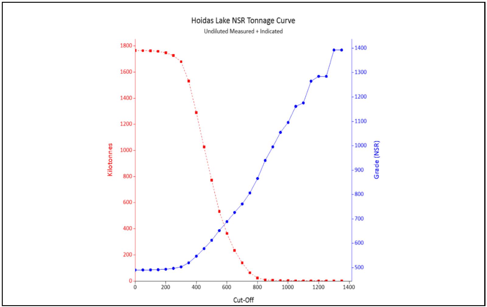
Figure dated November, 2024.
| 1.10.5 | Factors that Could Affect the Mineral Resource Estimate |
All estimation models have a degree of uncertainty associated with them, due to the assumptions used in their development. These uncertainties lead to risks in the relative accuracy of the models. In its independent review and verification of the previous mineral resource estimate model for the Hoidas Lake Project, Micon has used industry best practice guidelines and has reasonably mitigated much of the potential risks.
It is Micon’s opinion that the factors set out below could affect the mineral resource estimate.
| ● | The geological interpretations and assumptions used to generate the estimation domain. |
| ● | Mineralization and geologic geometry and continuity of the mineralized zones. |
| ● | Estimates of mineralization and grade continuity. |
| Hoidas Lake Rare Earth Element Property | 44 | December 6, 2024 |
|
REalloys Inc. |
| ● | The grade interpolation methods and estimation parameter assumptions. |
| ● | The confidence assumptions and methods used in the mineral resource classification. |
| ● | The density and the methods used in the estimation of density. |
| ● | Metal price and other economic assumptions used in the cut-off grade determination. |
| ● | Input and design parameter assumptions that pertain to the underground mining constraints. |
| ● | Assumptions as to the continued ability to access the test mine site, retain mineral and surface rights titles, maintain the operation within environmental and other regulatory permits, and maintain the social license to operate. |
| ● | Currently there are no environmental, permitting, legal, title, taxation, socio-economic, marketing, political or other relevant factors known to Micon that would materially affect the estimation of Mineral Resources, other that those discussed previously in this report. |
| 1.11 | Mineral Reserves |
There are currently no mineral reserves on the Hoidas Lake property.
| 1.12 | Mining Methods |
Underground longhole mining methods are being considered for the Hoidas Lake Project, though no details have been developed at this time.
| 1.13 | Process and Recovery Methods |
As noted in Section 1.9, the most recent study completed indicated that it is technically feasible to recover a rare earth concentrate in the form of a mixed RE carbonate and phosphorus as a Nitrogen-Phosphorus or NP-fertilizer. The process developed comprises flotation and magnetic separation to produce a rare earth concentrate and an apatite concentrate. These concentrates are then treated separately, using conventional hydrometallurgical technologies to extract rare earths and phosphorus. The overall RE recovery is 70% and phosphorus recovery is 93%. However, further studies as the Hoidas Lake Project advances are expected to refine the process and recovery methods.
| 1.14 | Infrastructure |
The current site infrastructure is discussed in Section 1.3. while detailed infrastructure suitable for an operation has not been determined at this time.
| 1.15 | Market Studies |
As noted in Section 1.10 the REE value pricing for La, Pr, Nd, Tb and Dy was taken from the 2024 Ashram REE Deposit Report and the other REEs value pricing are based on the information from the Ginger International Trade & Investment Pte., Ltd. website https://giti.sg/ in October, 2024. Further market studies will be required as the Project advances
| Hoidas Lake Rare Earth Element Property | 45 | December 6, 2024 |
|
REalloys Inc. |
| 1.16 | Environmental Studies, Permitting, and Plans, Negotiations, or Agreements with Local Individuals or Groups |
In order to conduct work on the Hoidas property, REalloys must first obtain permits to carry out the work. The necessary permits to be obtained from Saskatchewan Environment include one or more of the following:
| a) | Work Permit. |
| b) | Work Camp Permit. |
| c) | Timber Permit. |
| d) | Shore Line Alteration Permit. |
Permit applications must be submitted approximately 2 months in advance of the expected initiation of the field work. In addition, it will be necessary to obtain a permit to carry out work from Department of Fisheries and Oceans if any of the work is to take place on or near navigable waters.
There are no known environmental liabilities associated with the Hoidas Lake property. Additionally, there are no known significant factors that affect access or title to the property. However, as the Hoidas Lake Project advances further environmental baseline studies, indigenous consultations and permitting will be required as various phases as the project advances.
| 1.17 | Capital and Operating Costs |
Capital and operating costs have not been developed in detail at this time.
| 1.18 | Economic Analysis |
Economic analysis of the Hoidas Lake Project has not been completed at this time.
| 1.19 | Adjacent Properties |
There are no adjacent properties which would impact the interpretation of the rare earth element mineralization contained on the Hoidas Lake property. Most of the known zones of rare earth element mineralization in the area surrounding the Hoidas Lake deposit are located on the property.
| 1.20 | Other Relevant Data and Information |
| 1.20.1 | General Information |
All relevant data and information regarding REalloys’ Hoidas Lake Project are included in other sections of this Technical Report. Therefore, this section will discuss the company’s development approach to meet the immediate advanced magnet materials and magnet needs for US strategic stockpiles and US protected markets which include the Defence Industrial Base (DIB), Nuclear Industrial Base, Robotics, Electric Aviation and proscribed Critical Infrastructure.
REalloys is a US headquartered integrated rare earth mine-alloy-magnet supply company.
REalloys’ strategy is to integrate the Hoidas Lake upstream production of light and heavy rare earth concentrate with the Saskatchewan Research Council (SRC) facility in Saskatoon, under a toll agreement to provide midstream processing and separation of light RE metals, following which the resultant materials and raffinate will be shipped to the downstream Ohio facility. The Ohio facility will then conduct the final downstream processing of the light RE metals and raffinate into light and heavy rare earth magnet materials and magnets for delivery to US Protected Markets and US Strategic Stockpiles.
| Hoidas Lake Rare Earth Element Property | 46 | December 6, 2024 |
|
REalloys Inc. |
| 1.20.2 | REalloys and the Hoidas Lake Project |
In order to expedite the work at the Hoidas Lake Project, REalloys is planning on the following steps in conjunction with or in addition to the two-phase, exploration and environmental budget items totalling approximately CAD 7.3 million dollars described in Section 23 of this report:
| 1. | REalloys will continue discussions: |
| A. | With the Fond du Lac Nation and the provincial government to create pathways for employment and training, permitting and improved infrastructure. |
| B. | With SRC to finalize the scope of work for processing under a toll agreement. |
| C. | With metallurgical consultants for additional testwork to support further studies |
REalloys believes that the work contained in the budget for further exploration, metallurgical testwork, and the baseline environmental work, will enable REalloys to conduct pilot mining and extract a bulk sample of 30,000 tonnes which, after on-site processing, will be transported to the SRC facility in Saskatoon to assist in better determination of the economic potential of the Hoidas Lake Project and test the ability of the SRC facility to further extract and refine the mineralization.
| 1.21 | Interpretation and Conclusions |
REalloys retained Micon independently to review, verify and update with current parameters the previous mineral resource estimate (MRE) for the Hoidas Lake Rare Earth Element (REE) Project (Hoidas Lake Project) and to Technical Report disclosing the results of the MRE.
Barr supplied the electronic resource database for the Project to Micon, as Barr had undertaken the previous mineral resource estimate in 2009 for the Hoidas Lake Project. Micon reviewed and accepted most of the estimation work conducted by Barr, but Micon used its own judgement for mineral resource categorization and economic parameter assumptions and also used an NSR approach to report the mineral resource statement.
| Hoidas Lake Rare Earth Element Property | 47 | December 6, 2024 |
|
REalloys Inc. |
| 1.21.1 | Conclusions |
The 2024 mineral resource estimate has allowed REalloys to demonstrate that the Hoidas Lake Project has reasonable prospects for eventual economic extraction. Further exploration and metallurgical testwork will be necessary to refine the extent and nature of economic REE mineralization.
It is Micon’s opinion that the exploration programs conducted by the previous operators were conducted according to the mineral industry best practices guidelines put out by various organizations. Micon has also reviewed the QA/QC conducted by the previous operators of the Hoidas Lake Project and finds that the information obtained is suitable to continue being used as the basis for the 2024 mineral resource estimate. Therefore, Micon believes that the 2024 mineral resource estimate can be used as the basis for further exploration and development work on the Hoidas Lake Project.
| 1.21.2 | Risks, Mitigations and Opportunities |
All mineral resource estimates have a degree of uncertainty or risk associated with them due to technical, environmental, permitting, legal, title, taxation, socio-economic, marketing or political factors, among others. All mineral resource estimates also present their own opportunities. Table 1.11 outlines some of the Hoidas Project risks, their potential impact and possible means of mitigation. Table 1.10 also outlines some of the Hoidas Lake Project opportunities and potential benefits.
Table
1.11
Risks, Mitigations and Opportunities for the Hoidas Lake Project
| Risks | Description and Potential Impact | Possible Risk Mitigation |
| Local grade continuity issues | Poor grade forecasting. | Undertake further infill drilling to establish continuity of mineralization. |
| Local density variability | Misrepresentation of the in-situ tonnes, which also affects the in-situ metal content estimate. | It is recommended to develop a procedure of collecting density measurements spatially throughout the deposit at regular intervals in all rock/alteration types and implement their use in future mineralization models. |
| Geologic Interpretation. | If the geologic interpretation and assumptions (geometry and continuity) used are inaccurate, then there is a potential lack of grade or continuity. | Continue infill drilling to confirm the grade continuity which will also tend to upgrade the mineral inventory to at least the Indicated category. |
| Metallurgical recoveries are based on limited testwork. | Recovery might be lower than that which is currently being assumed or vary with rock type. | Conduct additional metallurgical tests on all rock types. |
| Difficulty in attracting experienced professionals. | Technical work quality will be impacted and/or delayed. | Refine recruitment and retention planning and/or make use of consultants. |
| Conceptual mine plans in future are based on limited geotechnical testwork. | Mining methods and dimensions selected might be different from what is currently being assumed. | Incorporate
more comprehensive geotechnical data from drilling. Conduct additional geotechnical assessment and analysis. |
| Environmental or social Issues | Further studies may be delayed, and the project may not advance due to environmental or social issues | Conduct meetings with all potential stake holders throughout the exploration and advanced development stages. Hire locals whenever possible. |
| Hoidas Lake Rare Earth Element Property | 48 | December 6, 2024 |
|
REalloys Inc. |
| Opportunities | Explanation | Potential Benefit |
| Surface exploration drilling. | Potential to identify additional prospects and resources. | Adding resources increases the economic value of the Project. |
| Potential improvement in metallurgical recoveries. | Additional metallurgical testwork can be performed to determine if recovery can be improved through ore sorting, flotation or cyanidation. | Lower capital and operating costs. |
| Potential improvement in mining assumptions. | Geotechnical analysis may determine that mining methods and dimensions can be improved. | Improved mining productivity and lower costs. |
| Potential additional economic minerals | All potentially economic minerals must be placed in the model such that changes in metal prices potentially allow for these to be added to the mineral resource estimate. | Further metallurgical testwork to determine if any other minerals can be recovered economically, than those already identified. |
| 1.22 | Recommendations |
| 1.22.1 | Budget for Further Work |
The budget presented in Table 1.12 summarizes the estimated costs for completing further exploration programs, metallurgical testwork, begin baseline studies, conduct social outreach programs with the various local groups and fast track further studies related to the Hoidas Lake Project. The budget is a cost estimate for one year of baseline environmental studies and two phases of exploration work which will culminate in an updated mineral resource estimate and further economic studies after the second phase.
Table
1.12
Hoidas Lake Project, Recommended Budget for Further Work
| Area | Description | Item | Period
or Amount |
Cost | Total (CAD$) |
| Exploration Phase 1 | Drilling
and Data Interpretation (Late January, – May, 2025) |
Geological staff, camp staff, and equipment rentals. | 2-month rentals | $474,535.00 | |
| Camp implementation and rental. | $63,416.67 | ||||
| Drilling. | 2,500 m | $420/m | $1,041,600.00 | ||
| Geochemical assays. | 40% sampling rate | $63,537.60 | |||
| Mobilization and crew transportation. | $80,000.00 | ||||
| Phase 1 Sub Total: | $1,723,089.27 | ||||
| Metallurgical Testwork | Ore sorting tests; bench scale beneficiation and hydrometallurgical tests to optimize the flowsheet and produce RE carbonates. | $150,000.00 | |||
| Total Exploration Phase 1: | $1,873,089.27 | ||||
| Exploration Phase 2 | Drilling and Field Work (Late June, - October, 2025) | Geological staff, camp staff, and equipment rentals. | Concurrent 2 to 4 month drill program and a 3 to 4 week field program | $791,099.32 | |
| Camp Implementation and rental. | 5 month rental | $70,200.00 | |||
| Drilling. | 7,500 m | $420/m | $3,225,600.00 | ||
| Geochemical assays. | 40% sampling rate | $190,620.00 | |||
| Mobilization and crew transportation. | $92,000.00 | ||||
| Phase 2 Subtotal: | $4,369,519.32 | ||||
| Metallurgical Testwork | Larger scale continuous or semi-continuous pilot plant testing including separation to produce RE oxides. | $300,000 | |||
| Total Exploration Phase 2: | $4,669,519.27 | ||||
| Year 1 Baseline Environmental Studies | Site Reconnaissance Studies | Site overview map, site description report, logistical assessment, photographic documentation. | $105,000.00 | ||
| Heritage Resource Studies | Heritage resource inventory, resource protection report, cultural impact assessment, documentation report | $170,000.00 | |||
| Surface Hydrology Studies | Hydrological map, water quality data, flow measurement impact assessment | $120,000.00 | |||
| Aquatic Resource Studies | Aquatic species, habitat condition, biological sample data, impact assessment | $180,000.00 | |||
| Terrestrial Resource Studies | Vegetation Wildlife, Soil conditions, impact assessment | $220,000.00 | |||
| Total Year 1, Baseline Environmental Studies | $795,000.00 | ||||
| Total Budget for the Exploration Phases and the Baseline Environmental Studies: | $7,337,608,59 | ||||
| Hoidas Lake Rare Earth Element Property | 49 | December 6, 2024 |
|
REalloys Inc. |
It is the opinion of Micon that all of the recommended work noted in the budget is warranted. Micon appreciates that the nature of the programs and expenditures may change as further studies are undertaken, or the company priorities change and that the final expenditures and results may not be the same as originally proposed.
Micon is of the opinion that REalloys’ recommended work program and proposed expenditures are appropriate and well thought out. Micon believes that the proposed budget reasonably reflects the type and amount of the activities required to advance the Hoidas Lake Project, with the next phase culminating in the publication of an updated mineral resource estimate and an economic study for the Project.
| 1.22.2 | Recommendations |
Micon recommends further exploration and development of the Hoidas Lake Project. It is recommended that REalloys continues with exploration at the Hoidas Lake deposit, as well as other REE mineralization showings on the property. It is also recommended that REalloys continues to conduct metallurgical testwork including different processing options for the varied rock assemblages and different REE minerals at the Hoidas Lake Project. To that end, Micon makes the following recommendations for the Hoidas Lake Project.
| 1) | Undertake a Lidar topographic survey of the Hoidas Lake Project, concentrating on those areas covered by the mineral deposits, as well as any areas that would be potentially used for mine infrastructure. |
| 2) | Undertake further mapping and sampling across the mineral deposits, paying particular attention to changes in alteration and geology. |
| 3) | Conduct continuous channel sampling across the Hoidas Lake deposit, at regular intervals along the strike of the deposit, as this information could be potentially incorporated into future mineral resource estimates. |
| 4) | Conduct detailed relogging of a number of drill holes to review the geological units and alteration types for the mineralized zones. |
| 5) | Conduct further density sampling to see if there is any variation between the mineralized zones or geological units. |
| 6) | Complet2e further resource infill and expansion drilling on the Hoidas Lake deposit to increase the confidence of the continuity of the REE mineralization and grade. |
| 7) | Continue mineral characterization including that for Uranium and Thorium, and REE ore deportment studies to support environmental design, planning for worker and public safety, metallurgical testwork, and process design. |
| 8) | Metallurgical testwork should be conducted on the Hoidas Lake and other mineralized showings to see if the metallurgical recoveries are different in the various geological rock types. |
| 9) | Conduct further diamond drill testing of the secondary exploration targets on the Hoidas Lake property. |
| 10) | Complete a new mineral resource estimate along with further economic studies. |
| Hoidas Lake Rare Earth Element Property | 50 | December 6, 2024 |
|
REalloys Inc. |
| 1.23 | REFERENCES |
| 1.23.1 | Technical Reports, Papers and Other Publications |
Guangzhou Research Institute of Non-ferrous Metals, (2010), “Preliminary Test Report on Process Mineralogy and Dressing-Metallurgy for Phosphorus and Rare earth ore from Hoidas Lake of Canada”
Ashton, K., Hartlaub, R., Heamon, L., Morelli, R., Card, C., Bethune, K., and Huner, R., (2009), “Post-Taltson Sedimentary and Intrusive History of the Southern Rae Province Along the Northern Margin of the Athabasca Basin, Western Canadian Shield.”
Ashton, K., Rayner, N., Bethune, K., (2009), “Meso – and Neoarchean Granitic Magmatism, Paleoproterozoic (2.375Ga and 1.9Ga) Metamorphism and 2.17 Ga Provenance Ages in Purmac Bay Group Pelite; U-Pb SHRIMP Ages from the Uranium city Area.
Barr Engineering, (2009), “Hoidas Lake Rare Earth Project Northern Mining District-Saskatchewan”
Billingsley, G., (2002), “43-101F1 Technical Report on the Hoidas Lake Rare Earth Project”
Cassoff J. et al. (2024), “NI 43-101 Technical Report, Mineral Resource Estimation for the Ashram Rare Earth Element and Fluorspar Deposit, Nunavik, Quebec, Canada prepared for Commerce Resources Corp.
Dunn, B.M., (2014), Update to Resource Estimate on the Hoidas Lake Property, Saskatchewan Canada, Report by Barr Engineering Co. for Star Minerals Group Ltd., 114 p.
Foster, F., (1965), “Geology of the Dardier Lake Area (West Half)” in DMR Report No. 101
Gent, M., (1998), “Assessment Work Report on the Hoidas Lake Property, Claim Block S-104987, Northern Mining District NTS 74-O-13”
Halpin, K., (2009) “The mineralogy, chemistry and paragenesis of the Hoidas Lake REE deposit, northwestern Saskatchewan” a power point presentation
Halpin, K., (2010), “The Characteristics and Origin of the Hoidas Lake REE Deposit”, M.Sc. Thesis, University of Saskatchewan; 257 p.
Halpin, K., (2011), “Hoidas Lake Rare Earth Element Project 2008 Drill Program Results”
Harper, C., (1986), “Geology of the Nevins _ Forsyth Lakes area (74O-5, -6, -11, and -12)”; Sask. Energy Mines, Open File Report 86-4, 57p
Harper, C., (2012), “Geology of the Hoidas Lake REE Deposit and Surrounding Area, Northwestern Saskatchewan.”
| Hoidas Lake Rare Earth Element Property | 51 | December 6, 2024 |
|
REalloys Inc. |
Harvey, S., Young, I., and Billingsley, G., (2002), “Geology of the Hoidas Lake Area, Ena Domain, Northwestern Saskatchewan” in Summary of Investigations 2002, Volume 2, Saskatchewan Geological Survey
Hogarth, D., (1957), “The Apatite Bearing Veins of Nisikkatch Lake, Saskatchewan” in Canadian Mineralogist, Volume 6, Part One
Kormos, L., and Chisholm, K., (2009), “Xstrata Process Support; Final Report – Great Western Minerals Group; Hoidas Lake QEMSCAN and EPMA Mineralogy”
Normand, C., McEwan, B., and Ashton, K., (2009), “Geology and REE Mineralization of the Hoidas Lake – Nisikkatch Lake area revisited.”
Pandur, K., (2015), “Magmatic-Hydrothermal Evolution of the Hoidas Lake REE Deposit, Northern Saskatchewan, Canada”, PHD. Thesis, University of Saskatchewan; 250 p.
Rossi, M. E. (2009), Accounting for Dilution in Ore Resource Estimation, Canadian Institute of Mining, Metallurgy and Petroleum, 8 p.
Wardrop Engineering, (2006), “Technical Report on the Hoidas Lake Rare Earth Project, Saskatchewan”
Wardrop Engineering, (2008), “Mineral Resource Estimate on the Hoidas Lake Rare Earth Project DRAFT”
Young, I., (2004), “43-101 Technical Report on the Hoidas Lake Rare Earth Project”
| 1.23.2 | Web Based Sources of Information |
Ginger International Trade & Investment Pte., Ltd. (Rare Earths Marketing): https://giti.sg/
“Mineral Deposit Index” in the Government of Saskatchewan website: www.er.gov.sk.ca/dbsearch/MinDepositQuery
“The Minerals Disposition Regulations, 1986” under the Crown Minerals Act, Government of Saskatchewan website: www.gov.sk.ca
| 1.24 | Reliance on Information Provided by the Registrant |
The QP authors of this Technical Report state that they are qualified persons for the areas included in this report. The QPs have relied, and believe there is a reasonable basis for this reliance, upon the following other expert reports, which provided information regarding mineral rights, surface rights, and environmental status in sections of this Report as noted below.
| 1.24.1 | Mineral Tenure and Surface Rights |
The QPs have not reviewed the mineral tenure, nor independently verified the legal status, ownership of the Project area or underlying property agreements. The QPs have fully relied upon, and disclaim responsibility for, information supplied by REalloys. This information is used in Section 3 of the Technical Report and Section 1.2 of this Executive Summary.
| 1.24.2 | Royalties and Incumbrances |
The QPs have not reviewed the royalty agreements nor independently verified the legal status of the royalties and other potential incumbrances. The QPs have fully relied upon, and disclaim responsibility for, information supplied by REalloys. This information is used in Section 3 of the Technical Report and Section 1.2 of this Executive Summary.
| Hoidas Lake Rare Earth Element Property | 52 | December 6, 2024 |