| | |
SEC Technical Report Summary Initial Assessment Wodgina Western Australia
Effective Date: September 30, 2020 Report Date: December 31, 2021 Amended Date: December 16, 2022 |
Report Prepared for Albemarle Corporation 4250 Congress Street Suite 700 Charlotte, North Carolina 28209
|
Report Prepared by SRK Consulting (U.S.), Inc. 1125 Seventeenth Street, Suite 600 Denver, CO 80202
SRK Project Number: 515800.040 |
SRK Consulting (U.S.), Inc.
| | | | | |
SEC Technical Report Summary – Wodgina | Page ii |
Table of Contents
| | | | | |
Wodgina_SK1300_Report_515800.040 | December 2022 |
SRK Consulting (U.S.), Inc.
| | | | | |
SEC Technical Report Summary – Wodgina | Page iii |
| | | | | |
Wodgina_SK1300_Report_515800.040 | December 2022 |
SRK Consulting (U.S.), Inc.
| | | | | |
SEC Technical Report Summary – Wodgina | Page iv |
| | | | | |
| 83 |
| 84 |
| 85 |
| 86 |
| 86 |
| 87 |
| 88 |
| 89 |
| 90 |
| 91 |
| 92 |
| 93 |
| 94 |
| 94 |
| 95 |
| 96 |
| Signature Page | 97 |
List of Tables
| | | | | |
Wodgina_SK1300_Report_515800.040 | December 2022 |
SRK Consulting (U.S.), Inc.
| | | | | |
SEC Technical Report Summary – Wodgina | Page v |
List of Figures
| | | | | |
Wodgina_SK1300_Report_515800.040 | December 2022 |
SRK Consulting (U.S.), Inc.
| | | | | |
SEC Technical Report Summary – Wodgina | Page vi |
| | | | | |
Wodgina_SK1300_Report_515800.040 | December 2022 |
SRK Consulting (U.S.), Inc.
| | | | | |
SEC Technical Report Summary – Wodgina | Page vii |
List of Abbreviations
The metric system has been used throughout this report. Tonnes are metric of 1,000 kg, or 2,204.6 lb. All currency is in U.S. dollars (US$) unless otherwise stated.
| | | | | |
| Abbreviation | Unit or Term |
| A | ampere |
| AA | atomic absorption |
A/m2 | amperes per square meter |
| °C | degrees Centigrade |
| CoG | cut-off grade |
| cm | centimeter |
cm2 | square centimeter |
cm3 | cubic centimeter |
| cfm | cubic feet per minute |
| ConfC | confidence code |
| CRec | core recovery |
| ° | degree (degrees) |
| dia. | diameter |
| g | gram |
| g/t | grams per tonne |
| ha | hectares |
| ICP | induced couple plasma |
| IDW2 | inverse-distance squared |
| IDW3 | inverse-distance cubed |
| kg | kilograms |
| km | kilometer |
km2 | square kilometer |
| kt | thousand tonnes |
| kt/d | thousand tonnes per day |
| kt/y | thousand tonnes per year |
| kV | kilovolt |
| kW | kilowatt |
| kWh | kilowatt-hour |
| kWh/t | kilowatt-hour per metric tonne |
| L | liter |
| L/sec | liters per second |
| L/sec/m | liters per second per meter |
| LOI | Loss On Ignition |
| LoM | Life-of-Mine |
| m | meter |
m2 | square meter |
m3 | cubic meter |
| masl | meters above sea level |
| mg/L | milligrams/liter |
| mm | millimeter |
mm2 | square millimeter |
mm3 | cubic millimeter |
| Mt | million tonnes |
| MTW | measured true width |
| MW | million watts |
| | | | | |
Wodgina_SK1300_Report_515800.040 | December 2022 |
SRK Consulting (U.S.), Inc.
| | | | | |
SEC Technical Report Summary – Wodgina | Page viii |
| | | | | |
| m.y. | million years |
| % | percent |
| ppm | parts per million |
| QA/QC | Quality Assurance/Quality Control |
| RC | rotary circulation drilling |
| RoM | Run-of-Mine |
| RQD | Rock Quality Description |
| SEC | U.S. Securities & Exchange Commission |
| sec | second |
| SG | specific gravity |
| t | tonne (metric ton) (2,204.6 pounds) |
| t/h | tonnes per hour |
| t/d | tonnes per day |
| t/y | tonnes per year |
| TSF | tailings storage facility |
| V | volts |
| VFD | variable frequency drive |
| W | watt |
| XRD | x-ray diffraction |
| y | year |
| | | | | |
Wodgina_SK1300_Report_515800.040 | December 2022 |
SRK Consulting (U.S.), Inc.
| | | | | |
SEC Technical Report Summary – Wodgina | Page 9 |
1Executive Summary
This report was prepared as an Initial Assessment-level (IA) Technical Report Summary in accordance with the Securities and Exchange Commission (SEC) S-K regulations (Title 17, Part 229, Items 601 and 1300 until 1305) for Albemarle Corporation (Albemarle) by SRK Consulting (U.S.), Inc. (SRK) on the Wodgina Mine asset (Wodgina).
The report was amended to include additional clarifying information in December 2022. The basis of the report is unchanged. The summary of the changes and location in document are summarized in Chapter 2.2.
1.1Property Description (Including Mineral Rights) and Ownership
The Wodgina property lies approximately 110 kilometers (km) south-southeast (S-SE) of Port Hedland, Western Australia between the Turner and Yule Rivers. The area includes multiple prominent ridges up to 180 m above mean sea level (mamsl) surrounded by plains and lowlands. The center of the property is located at Mount Cassiterite - 21° 11' 25"S, 118° 40' 25"E (World Geodetic System [WGS] 1984).
The property tenure is held under the joint venture of Albemarle Wodgina Pty Ltd. and Wodgina Lithium Pty Ltd. with ownership structure of 60% Albemarle Corporation and 40% Mineral Resources Ltd. (MRL). The operating joint venture entity is known as MARBL.
1.2Geology and Mineralization
The Wodgina pegmatite deposits (including the historic Wodgina, Mt. Cassiterite, and Tinstone pits) are hosted within the Paleoarchean East Strelley Greenstone Belt in the Pilbara Craton of Western Australia, Australia.
The property is located within the Wodgina Pegmatite District. This pegmatite district is entirely hosted in the eastern limb of the Wodgina greenstone belt along the southern portion of the Wodgina-Strelley lineament. This greenstone belt is a north-northeast (N-NE) plunging synform separating the Yule and Carlindi granitoid complexes within Central zone of the Pilbara Craton.
The Mt. Cassiterite pegmatite group is classified as a rare element albite-spodumene type pegmatite. Spodumene (LiAlSi2O6) is the primary lithium-bearing mineral. It is massive to weakly layered pegmatite with comb-textured megacrystic microcline and spodumene with aplitic layers often displaying pseudo gneissic banding. Unlike many other Pilbara Craton pegmatite bodies, the Mt. Cassiterite pegmatites tend to not display internal structure such as mineralogical layering or banding. Lithium minerals are predominantly spodumene and lepidolite. Prior to focusing on lithium production, the Mt. Cassiterite deposit was exploited for tantalum-bearing wodginite and cassiterite with subordinate maganocolumbite and manganotantalite with associated microcline alteration (Huston, et al., 2001). Other significant minerals include spessartine (Mn aluminosilicate garnet), elbaite (Na-Li alumino-boro-silicate tourmaline) and native Bi.
1.3Status of Exploration, Development and Operations
The Wodgina property is currently on care and maintenance by MARBL. The site has experienced intermittent production since the early twentieth century. The Mt. Cassiterite pit, the primary focus of
| | | | | |
Wodgina_SK1300_Report_515800.040 | December 2022 |
SRK Consulting (U.S.), Inc.
| | | | | |
SEC Technical Report Summary – Wodgina | Page 10 |
this TRS, is an open pit with maintained infrastructure on-site and access to regional roads and ports.
1.4Mineral Resource and Mineral Reserve Estimates
Mineral Resources were updated in September 2020 by SRK as summarized in Table 1-1.
Table 1-1: Wodgina Summary Mineral Resources at End of Fiscal Year Ended December 31, 2021 SRK Consulting (U.S.), Inc.
| | | | | | | | | | | | | | | | | |
| Category | 100% | Attributable | Li2O (%) | Cut-Off (% Li2O) | Mass Yield (%) |
| Tonnes | Tonnes |
| (Mt) | (Mt) |
| Indicated | 22.3 | 13.4 | 1.39 | 0.50 | 15.06% |
| Inferred | 164.2 | 98.5 | 1.15 | 0.50 | 12.46% |
Source: SRK, 2020
Notes:
• The Summary Mineral Resources attributable tonnes reflects Albemarle’s 60% ownership percentage in the Wodgina project.
The effective date for this Mineral Resource is September 30, 2020. All significant figures are rounded to reflect the relative accuracy of the estimates.
• Tonnages are presented as million tonnes (Mt) with lithium oxide (Li2O) grades presented as percentages.
• The Mineral Resource estimate has been classified in accordance with SEC S-K 1300 guidelines and definitions.
• The Cassiterite Deposit comprises the historically mined Mt. Cassiterite pit and undeveloped North Hill areas.
• Mineral Resources are not Mineral Reserves and do not have demonstrated economic viability. Inferred Mineral Resources have a high degree of uncertainty as to their economic and technical feasibility. It cannot be assumed that all or any part of an Inferred Mineral Resources can be upgraded to Measured or Indicated Mineral Resources.
• Metallurgical recovery of lithium has been estimated on a block basis at a consistent 65% based on documentation from historical plant production.
• To demonstrate reasonable prospects for eventual economic extraction of Mineral Resources, a cut-off grade of 0.5% Li2O based on metal recoverability assumptions, long-term lithium price assumptions of US$584 per tonne (t), variable mining costs averaging $3.40/t, processing costs and G&A costs totaling $23/t.
• There are no known legal, political, environmental, or other risks that could materially affect the potential development of the Mineral Resources based on the level of study completed for this property.
As the project-level is current at Initial Assessment-level, the property contains no Mineral Reserves.
1.5Conclusions and Recommendations
Wodgina is a large spodumene pegmatite deposit that features existing infrastructure for spodumene concentrate production, but which currently sits in care and maintenance. The geology of the site is relatively complex and features a number of challenges due to variations in morphology and mineralogy of the pegmatites. Such variability is common in spodumene pegmatites and is generally related to inherent structural complexity of host rocks, rheology of host rocks and the characteristics of various phases of pegmatite intrusion which commonly accompany lithium mineralization. SRK has considered all provided and relevant data in developing a more robust structural and lithological interpretation to constrain and control the mineral resource estimation (MRE). The lack of sufficient data to adequately characterize these aspects of certain areas of the project has been incorporated in the mineral resource classification process. It is expected that risks in the geological interpretation and MRE are likely to remain until extensive additional geological work has been done across the deposit, and that ongoing de-risking through closely spaced drilling is likely to be a part of downstream mining development.
Wodgina is a previously mined project with an extensive operational background in elements other than lithium. Despite this, lithium production is a relatively recent addition to Wodgina (effectively post-2016), with the majority of the lithium information being generated or characterized from remnant historic tin/tantalum drilling. All data supporting the current MRE was provided to SRK by MARBL, and exploration and development of Wodgina continues.
| | | | | |
Wodgina_SK1300_Report_515800.040 | December 2022 |
SRK Consulting (U.S.), Inc.
| | | | | |
SEC Technical Report Summary – Wodgina | Page 11 |
While Wodgina features extensive drilling and previous production, significant uncertainty around the deposit remains. SRK has accounted for these risks in the MRE process and classification, and notes that the following additional work is recommended for the project going forward:
•Characterize the mineralogy and process recoverability of both the Mt. Cassiterite and North Hill areas of Wodgina. SRK understands this to be ongoing in new drilling on the project at this time.
•Refine the structural model for Wodgina utilizing core drilling to collect accurate structural measurements and provide influence in updated geological modeling and MRE.
•Characterize the recoverability and process for the existing tin/tantalum operation tailings, which have been noted to contain significant quantities of lithium.
•If production is to be advanced at Wodgina, closely spaced grade control drilling and short-term planning should be considered to de-risk areas.
•The project should advance to pre-feasibility study (PFS) levels of development with accompanying technical study of relevant modifying factors of the mineral resource.
| | | | | |
Wodgina_SK1300_Report_515800.040 | December 2022 |
SRK Consulting (U.S.), Inc.
| | | | | |
SEC Technical Report Summary – Wodgina | Page 12 |
2Introduction
2.1Registrant for Whom the Technical Report Summary was Prepared
This Technical Report Summary was prepared in accordance with the SEC S-K regulations (Title 17, Part 229, Items 601 and 1300 through 1305) for Albemarle by SRK on the Wodgina property located in Western Australia, Australia. Albemarle has a 60% ownership in Wodgina with MRL retaining the remaining 40%. The joint venture operating entity is titled MARBL.
2.2Terms of Reference and Purpose of the Report
The quality of information, conclusions, and estimates contained herein are consistent with the level of effort involved in SRK’s services, based on i) information available at the time of preparation and ii) the assumptions, conditions, and qualifications set forth in this report. This report is intended for use by Albemarle, and is subject to the terms and conditions of its contract with SRK and relevant securities legislation. The contract permits Albemarle to file this report as a Technical Report Summary with American securities regulatory authorities pursuant to the SEC S-K regulations, more specifically Title 17, Subpart 229.600, item 601(b)(96) - Technical Report Summary and Title 17, Subpart 229.1300 - Disclosure by Registrants Engaged in Mining Operations. Except for the purposes legislated under securities law, any other uses of this report by any third party are at that party’s sole risk. The responsibility for this disclosure remains with Albemarle.
The purpose of this Technical Report Summary is to report mineral resources as part of an initial assessment. The IA is preliminary in nature, it includes Inferred Mineral Resources that are considered too speculative geologically to have the economic considerations applied to them that would enable them to be categorized as Mineral Reserves, and there is no certainty that the IA will be realized. Mineral Resources that are not Mineral Reserves do not have demonstrated economic viability.
The report was revised to include additional clarifying information in December 2022. The basis of the report is unchanged. The changes and location in document are summarized as follows:
•Amended date of report on title page
•Resource totals adjusted to reflect Albemarle 60% ownership (Chapter 1.4 and 11.8)
•Additional QP comment on adequacy of metallurgical testing (Chapter 8.3, 10, 14)
2.3Sources of Information
This report is based, in part on internal Company technical reports, previous studies, maps, published government reports, Company letters and memoranda, and public information as cited throughout this report and listed in the References Section 24.
Reliance upon information provided by the registrant is listed in the Section 25, when applicable.
2.4Details of Inspection
Due to the global pandemic, no site inspection has been conducted on the property by Qualified Persons (QP). Site visits are in-plan by QPs once travel restrictions and health and safety are considered acceptable for travel.
| | | | | |
Wodgina_SK1300_Report_515800.040 | December 2022 |
SRK Consulting (U.S.), Inc.
| | | | | |
SEC Technical Report Summary – Wodgina | Page 13 |
2.5Qualified Person
This report was prepared by SRK Consulting (U.S.), Inc., a third-party firm comprising mining experts in accordance with § 229.1302(b)(1). Albemarle has determined that SRK meets the qualifications specified under the definition of qualified person in § 229.1300. References to the Qualified Person or QP in this report are references to SRK Consulting (U.S.), Inc. and not to any individual employed at SRK.
2.6Report Version Update
This TRS is not an update of a previously filed Technical Report Summary. This report represents an IA as defined by SEC S-K 1300 definitions.
| | | | | |
Wodgina_SK1300_Report_515800.040 | December 2022 |
SRK Consulting (U.S.), Inc.
| | | | | |
SEC Technical Report Summary – Wodgina | Page 14 |
3Property Description
3.1Property Location
The Wodgina property lies approximately 110 km S-SE of Port Hedland, Western Australia between the Turner and Yule Rivers. The area includes multiple prominent greenstone ridges up to 180 mamsl surrounded by granitic plains and lowlands. The center of the property is located at Mount Cassiterite - 21° 11' 25"S, 118° 40' 25"E (WGS, 1984).
The property tenure is held under the joint venture of Albemarle Wodgina Pty Ltd. and Wodgina Lithium Pty Ltd. with ownership structure of 60% Albemarle and 40% MRL. The joint company is known as MARBL. A location map of the Wodgina property is shown in Figure 3-1 and Figure 3-2.
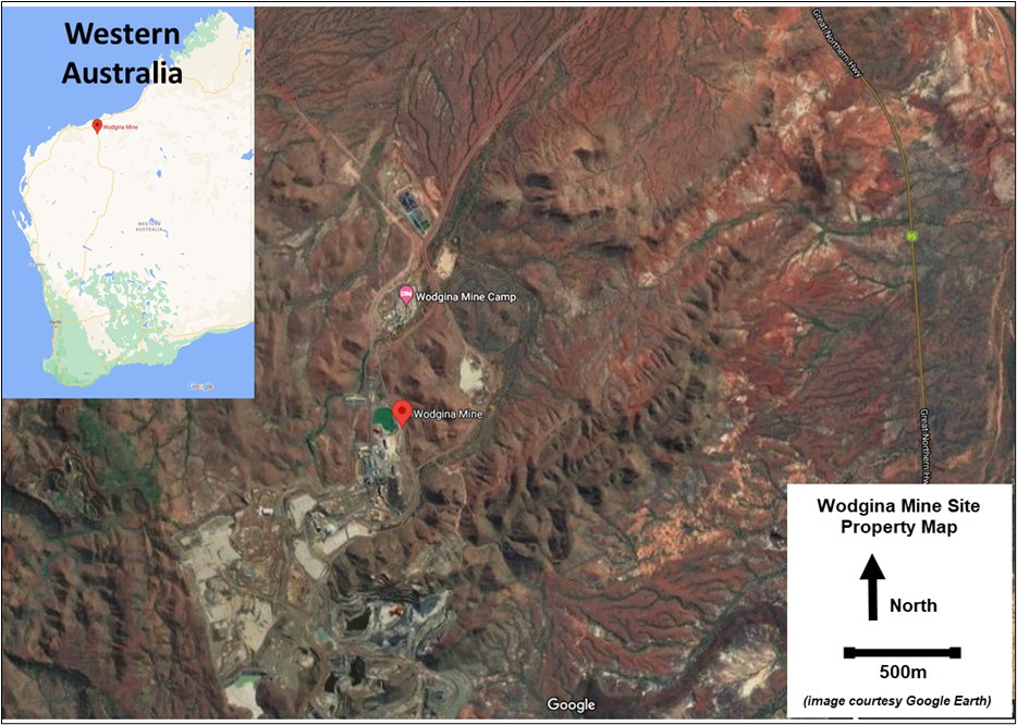 Source: Modified after Google
Figure 3-1: Location Map of the Wodgina Property, Western Australia, Australia
| | | | | |
Wodgina_SK1300_Report_515800.040 | December 2022 |
SRK Consulting (U.S.), Inc.
| | | | | |
SEC Technical Report Summary – Wodgina | Page 15 |
Source: MARBL, 2021
Figure 3-2: Wodgina Property Tenure Map
| | | | | |
Wodgina_SK1300_Report_515800.040 | December 2022 |
SRK Consulting (U.S.), Inc.
| | | | | |
SEC Technical Report Summary – Wodgina | Page 16 |
3.2Property Area
The total area of leases covering the Wodgina property cover a total of 111.4 square kilometers (km2) (43 square miles [mi]) (DMP, 2021). This includes various tenement types of general purpose and mining leases along with retention and miscellaneous licenses.
3.3Mineral Title, Claim, Mineral Right, Lease or Option Disclosure
The Wodgina property is located on Mining Lease M45/50, M45/353, and M45/887. These tenements are located within the Karriyarra native title claim and are subject to the Land Use Agreement dated March 2001 between the Karriyarra People and Gwalia Tantalum Ltd. (now the joint venture partners of Albemarle and MRL). All tenements are in good standing with no known impediments as of the effective date of this report (DMP, 2021).
Payment associated with tenement renewal to the State of Western Australia are:
•Mining Lease – AU$100 per hectare (ha), minimum AU$5,000
•General Purpose Lease – AU$17.90 per ha rent payment per annum
•Miscellaneous License – AU$17.90 per ha rent payment per annum
| | | | | |
Wodgina_SK1300_Report_515800.040 | December 2022 |
SRK Consulting (U.S.), Inc.
| | | | | |
SEC Technical Report Summary – Wodgina | Page 17 |
Table 3-1: Land Tenure Table
| | | | | | | | | | | | | | | | | | | | | | | | | | | | | | | | |
| Tenement ID | Tenement Type | Survey Status | Status | Holders | Grant Date (DD/MM/YYYY) | End Date (DD/MM/YYYY) | Fmt_Tenid | Legal Area (Ha) | Special_ Ind | Extract_ Date |
| G4500029 | General purpose lease | Surveyed | Live | Albemarle Wodgina Pty Ltd; Wodgina Lithium Pty Ltd | 18/07/1990 | 25/07/2032 | G45/29 | 9.6505 | | 11/05/2021 12:00:00 AM |
| G4500269 | General purpose lease | Surveyed | Live | Albemarle Wodgina Pty Ltd; Wodgina Lithium Pty Ltd | 27/01/2005 | 28/01/2026 | G45/269 | 9.612 | | 11/05/2021 12:00:00 AM |
| G4500270 | General purpose lease | Surveyed | Live | Albemarle Wodgina Pty Ltd; Wodgina Lithium Pty Ltd | 27/01/2005 | 28/01/2026 | G45/270 | 9.043 | | 11/05/2021 12:00:00 AM |
| G4500271 | General purpose lease | Surveyed | Live | Albemarle Wodgina Pty Ltd; Wodgina Lithium Pty Ltd | 27/01/2005 | 28/01/2026 | G45/271 | 9.3595 | | 11/05/2021 12:00:00 AM |
| L4500093 | Miscellaneous license | Unsurveyed | Live | Albemarle Wodgina Pty Ltd; Wodgina Lithium Pty Ltd | 25/03/1998 | 24/03/2023 | L45/93 | 134.9 | | 11/05/2021 12:00:00 AM |
| 4500058 | Miscellaneous license | Unsurveyed | Live | Albemarle Wodgina Pty Ltd; Wodgina Lithium Pty Ltd | 09/12/1988 | 08/12/2023 | L45/58 | 95 | | 11/05/2021 12:00:00 AM |
| L4500064 | Miscellaneous license | Unsurveyed | Live | Albemarle Wodgina Pty Ltd; Wodgina Lithium Pty Ltd | 18/05/1990 | 17/05/2025 | L45/64 | 1 | | 11/05/2021 12:00:00 AM |
| L4500105 | Miscellaneous license | Unsurveyed | Live | Albemarle Wodgina Pty Ltd; Wodgina Lithium Pty Ltd | 01/06/2001 | 31/05/2022 | L45/105 | 1682 | | 11/05/2021 12:00:00 AM |
| L4500009 | Miscellaneous license | Unsurveyed | Live | Albemarle Wodgina Pty Ltd; Wodgina Lithium Pty Ltd | 19/10/1984 | 03/07/2026 | L45/9 | 12.5 | | 11/05/2021 12:00:00 AM |
| L4500108 | Miscellaneous license | Unsurveyed | Live | Albemarle Wodgina Pty Ltd; Wodgina Lithium Pty Ltd | 29/06/2001 | 28/06/2022 | L45/108 | 1560 | | 11/05/2021 12:00:00 AM |
| M4500050 | Mining lease | Surveyed | Live | Albemarle Wodgina Pty Ltd; Wodgina Lithium Pty Ltd | 28/06/1984 | 03/07/2026 | M45/50-I | 364.5 | I | 11/05/2021 12:00:00 AM |
| M4500382 | Mining lease | Surveyed | Live | Albemarle Wodgina Pty Ltd; Wodgina Lithium Pty Ltd | 05/07/1988 | 11/07/2030 | M45/382 | 58.24 | | 11/05/2021 12:00:00 AM |
| M4500886 | Mining lease | Surveyed | Live | Albemarle Wodgina Pty Ltd; Wodgina Lithium Pty Ltd | 22/03/2001 | 21/03/2022 | M45/886 | 6.81 | | 11/05/2021 12:00:00 AM |
| M4500887 | Mining lease | Surveyed | Live | Albemarle Wodgina Pty Ltd; Wodgina Lithium Pty Ltd | 22/03/2001 | 21/03/2022 | M45/887-I | 30.575 | I | 11/05/2021 12:00:00 AM |
| M4500049 | Mining lease | Surveyed | Live | Albemarle Wodgina Pty Ltd; Wodgina Lithium Pty Ltd | 28/06/1984 | 03/07/2026 | M45/49 | 85.95 | | 11/05/2021 12:00:00 AM |
| M4500924 | Mining lease | Surveyed | Live | Albemarle Wodgina Pty Ltd; Wodgina Lithium Pty Ltd | 26/03/2001 | 25/03/2022 | M45/924-I | 520.1 | I | 11/05/2021 12:00:00 AM |
| M4500383 | Mining lease | Surveyed | Live | Albemarle Wodgina Pty Ltd; Wodgina Lithium Pty Ltd | 05/07/1988 | 11/07/2030 | M45/383-I | 110.6 | I | 11/05/2021 12:00:00 AM |
| M4500925 | Mining lease | Surveyed | Live | Albemarle Wodgina Pty Ltd; Wodgina Lithium Pty Ltd | 26/03/2001 | 25/03/2022 | M45/925-I | 612.55 | I | 11/05/2021 12:00:00 AM |
| M4500950 | Mining lease | Surveyed | Live | Albemarle Wodgina Pty Ltd; Wodgina Lithium Pty Ltd | 11/07/2001 | 10/07/2022 | M45/950-I | 677.8 | I | 11/05/2021 12:00:00 AM |
| M4500949 | Mining lease | Surveyed | Live | Albemarle Wodgina Pty Ltd; Wodgina Lithium Pty Ltd | 11/07/2001 | 10/07/2022 | M45/949 | 804.15 | | 11/05/2021 12:00:00 AM |
| M4500254 | Mining lease | Surveyed | Live | Albemarle Wodgina Pty Ltd; Wodgina Lithium Pty Ltd | 19/10/1987 | 28/10/2029 | M45/254 | 77.97 | | 11/05/2021 12:00:00 AM |
| | | | | |
Wodgina_SK1300_Report_515800.040 | December 2022 |
SRK Consulting (U.S.), Inc.
| | | | | |
SEC Technical Report Summary – Wodgina | Page 18 |
| | | | | | | | | | | | | | | | | | | | | | | | | | | | | | | | |
| M4500353 | Mining lease | Surveyed | Live | Albemarle Wodgina Pty Ltd; Wodgina Lithium Pty Ltd | 15/05/1988 | 18/05/2030 | M45/353 | 35.395 | | 11/05/2021 12:00:00 AM |
| M4500381 | Mining lease | Surveyed | Live | Albemarle Wodgina Pty Ltd; Wodgina Lithium Pty Ltd | 05/07/1988 | 11/07/2030 | M45/381 | 287.65 | | 11/05/2021 12:00:00 AM |
| M4500365 | Mining lease | Surveyed | Live | Albemarle Wodgina Pty Ltd; Wodgina Lithium Pty Ltd | 02/10/1988 | 09/10/2030 | M45/365-I | 206.6 | I | 11/05/2021 12:00:00 AM |
| M4500888 | Mining lease | Surveyed | Live | Albemarle Wodgina Pty Ltd; Wodgina Lithium Pty Ltd | 22/03/2001 | 21/03/2022 | M45/888 | 12.755 | | 11/05/2021 12:00:00 AM |
| G4500290 | General purpose lease | Surveyed | Live | Albemarle Wodgina Pty Ltd; Wodgina Lithium Pty Ltd | 22/01/2010 | 21/01/2031 | G45/290 | 9.945 | | 11/05/2021 12:00:00 AM |
| G4500291 | General purpose lease | Surveyed | Live | Albemarle Wodgina Pty Ltd; Wodgina Lithium Pty Ltd | 22/01/2010 | 21/01/2031 | G45/291 | 9.677 | | 11/05/2021 12:00:00 AM |
| G4500321 | General purpose lease | Surveyed | Live | Albemarle Wodgina Pty Ltd; Wodgina Lithium Pty Ltd | 05/10/2011 | 04/10/2032 | G45/321 | 296.55 | | 11/05/2021 12:00:00 AM |
| L4500443 | Miscellaneous license | Unsurveyed | Live | Albemarle Wodgina Pty Ltd; Wodgina Lithium Pty Ltd | 05/11/2018 | 04/11/2039 | L45/443 | 196.405 | | 11/05/2021 12:00:00 AM |
| L4500451 | Miscellaneous license | Unsurveyed | Live | Albemarle Wodgina Pty Ltd; Wodgina Lithium Pty Ltd | 05/02/2019 | 04/02/2040 | L45/451 | 1.674 | | 11/05/2021 12:00:00 AM |
| R4500004 | Retention license | Unsurveyed | Live | Albemarle Wodgina Pty Ltd; Wodgina Lithium Pty Ltd | 21/07/2017 | 20/07/2022 | R45/4 | 2469 | | 11/05/2021 12:00:00 AM |
| L4500452 | Miscellaneous license | Unsurveyed | Live | Albemarle Wodgina Pty Ltd; Wodgina Lithium Pty Ltd | 05/02/2019 | 04/02/2040 | L45/452 | 5.992 | | 11/05/2021 12:00:00 AM |
| L4500437 | Miscellaneous license | Unsurveyed | Live | Albemarle Wodgina Pty Ltd; Wodgina Lithium Pty Ltd | 11/04/2018 | 10/04/2039 | L45/437 | 733.23 | | 11/05/2021 12:00:00 AM |
| L4500441 | Miscellaneous license | Unsurveyed | Live | Albemarle Wodgina Pty Ltd; Wodgina Lithium Pty Ltd | 21/11/2018 | 20/11/2039 | L45/441 | 0.82 | | 11/05/2021 12:00:00 AM |
Source: DMP, 2021
| | | | | |
Wodgina_SK1300_Report_515800.040 | December 2022 |
SRK Consulting (U.S.), Inc.
| | | | | |
SEC Technical Report Summary – Wodgina | Page 19 |
1.4Mineral Rights Description and How They Were Obtained
Mineral rights were obtained by the registrant through a joint venture agreement (JV) in 2018 between Albemarle Corporation and Mineral Resources Ltd when the registrant acquired a 60% interest in the Wodgina property to form the JV MARBL.
The mining lease tenements are retained through meeting the requirements set forth by the State of Western Australia, Department of Mines and Petroleum (DMP). Renewal applications are met for 12-month periods by providing justification to the DMP for reasons of renewal with accompanying rent payments.
1.5Encumbrances
SRK has relied upon the legal information regarding title provided by Albemarle as noted in section 25, and is unaware of any encumbrances upon the Wodgina property.
1.6Other Significant Factors and Risks
SRK is unaware of any significant factors or risks that may affect property access, title or the right to perform work on the Wodgina property.
1.7Royalties or Similar Interest
Table 3-2 represents the royalty and liabilities in-place for the Wodgina property.
Table 3-2: Summary Royalty and Liabilities.
| | | | | |
| Royalties/Liability | Details of Amounts Payable |
| Mine Rehabilitation Fund (MRF) Funding for Closure including payment offset obligations | Annual MRF levy $ 157,093.76 (1% of the Liability according to the MRF) Based on 653.46Ha Disturbance and 242.32Ha Rehabbed |
| Royalties payable under Pastoral and Native Title Agreements | $450,000 per annum payment owed to the Kariyarra People’s Trust (pursuant to Land Use Agreement for Wodgina Mine between the Karriyarra People and Gwalia Tantalum Pty Ltd dated 8 March 2001) We did not identify a royalty fee for the Wallareenya Pastoral Lease. |
| Royalties payable under Global Advanced Metals (GAM) Agreement | Royalties owed by Wodgina Lithium Pty Ltd (WLPL) to GAM: M 45/381 (WLPL to pay 1.75% royalty to GAM). M 45/382 M 45/383 M 45/886 (WLPL to pay 1.75% royalty to GAMG). Clause 2 of the Lithium Royalty Deed dated 8 September 2016 between Global Advanced Metals Wodgina Pty Ltd (GAMW), GAMG and Global Advanced Metals (GAM) provides that the Royalty payable by the Grantor (GAMW) to the Grantee (GAMG) will be 1.75% on Gross Revenue (in relation to Lithium extracted and recovered from processing the Tailings extracted from the Tailings Dam situated on the dam or reservoir situated on the area the subject of the Tenements) in respect of each Royalty Period (30/6, 30/9, 31/12, 31/3). |
Source: Personal Communication – MRL, 2021
| | | | | |
Wodgina_SK1300_Report_515800.040 | December 2022 |
SRK Consulting (U.S.), Inc.
| | | | | |
SEC Technical Report Summary – Wodgina | Page 20 |
4Accessibility, Climate, Local Resources, Infrastructure and Physiography
The Wodgina property lies approximately 110 km south-southeast of Port Hedland, Western Australia between the Turner and Yule Rivers. The area includes multiple prominent greenstone ridges up to 180 mamsl surrounded by granitic plains and lowlands. The center of the open cut mine at Mount Cassiterite is located at the latitude and longitude of -21° 11' 25"S, 118° 40' 25"E.
4.1Topography, Elevation and Vegetation
The topography onsite varies between 150 mamsl and 330 mamsl (500 ft and 1,100 ft) and is described as rolling hills and valleys. The vegetation onsite is considered a combination of grassland with spare shrubs with predominant species being Triodia basedowii and Triodia schinzii. The general topography and site elevation is demonstrated in Figure 4-1.
Source: Atlas Iron Ore, 2021
Figure 4-1: Oblique Aerial View of the Wodgina Camp Looking South to the Minesite
4.2Means of Access
The property is accessible via National Highway 1 to National highway 95 to the Wodgina camp road. All roads to site are sealed bitumen. The nearest large regional airport is in Port Hedland which also hosts an international deep-water port facility. A site dedicated all-weather airstrip is located onsite capable of landing A320 jet aircrafts.
| | | | | |
Wodgina_SK1300_Report_515800.040 | December 2022 |
SRK Consulting (U.S.), Inc.
| | | | | |
SEC Technical Report Summary – Wodgina | Page 21 |
Source: Modified after MRL, 2018
Figure 4-2: Regional Road and Rail Infrastructure
4.3Climate and Length of Operating Season
The climate of the Wodgina property is categorized as a hot desert climate characterized by hot summers (average 40 to 45º Celsius [C]) and mild winters (average 20ºC). The majority of precipitation occurs during the summer months with annual averages around 300 millimeters (mm) per year (DPIRG, 2021).
Due to the hot to mild climate of the area, the Wodgina property maintains a year-round operating season.
4.4Infrastructure Availability and Sources
The Wodgina property has year-round availability of infrastructure; a water bore field, a natural gas pipeline, an accommodation camp, sealed road access, and a dedicated airstrip able to service A320 jets.
The property is currently in care and maintenance with site infrastructure available but not currently in-use. Equipment, infrastructure, and assets at the Wodgina property including the following:
•Three stage crushing plant capable of sustaining 5.65 million tonnes per annum (Mt/a) of ore feed to the Spodumene concentration plant
| | | | | |
Wodgina_SK1300_Report_515800.040 | December 2022 |
SRK Consulting (U.S.), Inc.
| | | | | |
SEC Technical Report Summary – Wodgina | Page 22 |
•Administrative and office buildings
•750-room accommodation camp on the property
•81 km long, 10-inch gas pipeline to site
•32 each 2-megawatt (MW) gas gensets for a total power station size of 64 MW
•Three mature and reliable water bore fields with minimal contaminant removal required
•All weather airstrip capable of landing A320 jet aircraft
•Extension of TSF3 for future tailing storage
4.4.1Water
Water is obtained from three dedicated water bore fields located on the property.
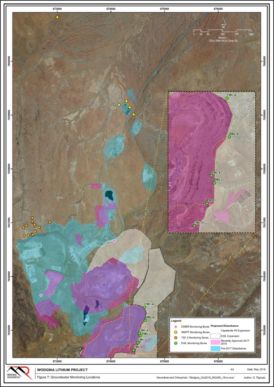
A series of monitoring bores are installed around the toe of the Eastern Waste Landform (EWL). These monitoring bores require monthly reporting on water levels and quarterly reporting on ambient groundwater quality and will continue to be monitored for any analytical signs that acid production is occurring within the waste landform.
Groundwater data for the EWL monitoring bores is only in its infancy for WLPL, monitoring was conducted from September 2017 through closure of the operation in November 2019. Data collected from these monitoring bores in the last year of the operation has been compared against Australian and New Zealand Environment and Conservation Council’s (ANZECC) livestock drinking water guideline. The only exceedance reported was for total dissolved solids (TDS), which is consistent with the natural variation in the area.
4.4.2Electricity
The Wodgina property has a dedicated 10-inch natural gas pipeline which runs from the Pilbara Energy pipeline to the property. The pipeline feeds the site power station which consists of 32 generator sets sized at 2 MW each with a total capacity of 64 MW. The natural gas pipeline was upgraded from 4-inch to 10-inch pipe in 2019.
4.4.3Personnel
The Wodgina property maintains a 750-room accommodation camp located on-site. Personnel access the camp via sealed highway or the on-site airstrip servicing a fly-in fly-out (FIFO) workforce based in a larger population area such as Perth.
4.4.4Supplies
The Wodgina property is supplied via road access well-maintained roadways or via the on-site airstrip.
| | | | | |
Wodgina_SK1300_Report_515800.040 | December 2022 |
SRK Consulting (U.S.), Inc.
| | | | | |
SEC Technical Report Summary – Wodgina | Page 23 |
5History
The Wodgina pegmatite deposits were discovered in 1902. Since then, the pegmatite-hosted deposits have been mined for tin, tantalum, beryl, and lithium. Tantalum production began in 1905, with most early production sourced from alluvial and eluvial deposits.
Tantalite was discovered at the location in 1901 by Francis and William Michell, who subsequently mined 70 t of ore between 1905 and 1909. In the early part of the twentieth century, Tantalite was a rare commodity, and despite its remoteness, Wodgina supplied most of the world's Tantalite. In the early years of mining, the ore was carted by camel to the coast for export. Tantalite Ltd was formed by Lady Deborah V. Hackett-Moulden and N.S. Young. Tantalite Ltd mined the site between 1925 to 1943, exporting tantalite ore concentrate mainly to the United States.
In 1943, the mine was taken over by the Australian Government as part of its wartime effort. Tantalite concentrate continued to be exported to the United States, and in addition, during this period beryl was exported. In 1927, geologist E.S Simpson had identified large masses of cesium bearing white beryl at the northern end of the pegmatite.
After World War II, Tantalite Ltd, continued to operate the mine, however, by 1953 it had run out of funds, and the mine was sold to Northwest Tantalum Ltd. This company found its new purchase to be uneconomic and relinquished the lease by 1957. Between 1957 to 1963 the mine was operated by prospector L.J. Wilson. In 1963, the mine was purchased by J.A. Johnson and Sons Pty Ltd, by Avela in 1967, and by Goldrim Mining in 1968. Goldrim formed a partnership with Goldfield Corp (New York) and Chemalloy Minerals Ltd (Toronto).
The investigations into the pegmatite by this last JV discovered the new species Wodginite. Mining occurred sporadically until Goldrim formed a new partnership with Pan West Tantalum Pty Ltd, who began open pit mining at the site in 1989. By 1994, most of the pegmatite had been removed and mining ceased from the Wodgina Pit.
The Mount Cassiterite pit operations were established in 1989 and progressively expanded during the 1990s. A major expansion in 2002 increased the mine's capacity to 635 t of tantalum pentoxide (Ta2O5) per annum. The mining operation extracted tantalum bearing pegmatite ores from the Mount Cassiterite and Tinstone open pits. The ores were crushed, milled and fed into the Wodgina plant's advanced gravity separation. A primary tantalum concentrate is produced at Wodgina, and then sent to the Greenbushes mining operation for secondary processing to produce on-specification, saleable tantalum products. The mine was placed on care and maintenance in 2008, 2012, and most recently in 2019. The current owners of the Wodgina property are the JV MARBL. There is no active mining on the property at the time of this report.
5.1Previous Operations
The ownership of the Wodgina property has changed multiple time since initial mineralization discovery in 1902. Details of past owners have been compiled from various sources but remain incomplete and vague in terms of the details around ownership (Table 5-1).
| | | | | |
Wodgina_SK1300_Report_515800.040 | December 2022 |
SRK Consulting (U.S.), Inc.
| | | | | |
SEC Technical Report Summary – Wodgina | Page 24 |
Table 5-1: Ownership History of the Wodgina Property
| | | | | |
| Years | Owners |
| 1901 - 1909 | Francis and William Michell |
| 1925 - 1943 | Tantalite Ltd. |
| 1943 - 1945 | Australian Commonwealth government |
| 1945 - 1953 | Tantalite Ltd. |
| 1953 - 1957 | Northwest Tantalum Ltd. |
| 1957 - 1963 | L. J. Wilson |
| 1963 - 1967 | J.A. Johnson and Sons Pty Ltd. |
| 1967 | Avela |
| 1968 - 1989 | Goldrim Mining/Goldfield Corp |
| 1989 - 2001 | Goldrim and Pan West Tantalum Pty Ltd. JV |
| 2001 - 2005 | Sons of Gwalia |
| 2005 - 2009 | Talison Minerals |
| 2009 - 2016 | Global Advanced Metals (previously known as Talison Tantalum) |
| 2016 - 2019 | Mineral Resource Ltd. |
| 2019 | MARBL (JV between Mineral Resource Ltd. and Albemarle Corp.) |
Source: SRK, 2020 compiled from multiple publications.
5.2Exploration and Development of Previous Owners or Operators
There is no known documentation available related to historic exploration work on the Property. There have been numerous governmental and academic studies on the occurrences of pegmatite, variable mineralogy, and mineralization in the Wodgina pegmatite district. Work has included regional scale mapping by the Geological Survey of Western Australia (GSWA, 2001), scientific publications from Geoscience Australia, and various technical studies by the multitude of operating companies.
Exploration and development history for the property includes a variety of owners with sporadic production of multiple products over the life of the Wodgina property. Due to the complex nature of production and limited historic data available, the following represents a high-level account of production history on the property:
•Pre-1945: Various Producers: The Wodgina main load produced 85 t of beryl
•Pre-1984: Various Producers: The Wodgina main load produced 269 t of tantalum and an inferred 44 t of niobium
•Global Advanced Metals (GAM)/Talison: Mining was focused on in the Mt. Cassiterite Pit area
◦Prior to 1988: The Mt. Cassiterite pit area produced an estimated 308 t of tantalum, 193 t of tin, and 39 t of niobium
◦1988 to 1994: Wodgina main load pit ceased operation
◦Late 1990s into early 2000s: The Tinstone Pit commenced production
◦2001 to 2002: FY production of 442 t of Ta2O5 concentrate
◦2008: Mine placed in care and maintenance
◦2010 to 2011: Mining restarted
◦2012: Mine placed in care and maintenance
•Mineral Resources Ltd. operated the Mt. Cassiterite pit from April 2017 until November 2019
•MARBL was formed in late 2019 with the property immediately placed in care and maintenance after closure of the JV agreement.
| | | | | |
Wodgina_SK1300_Report_515800.040 | December 2022 |
SRK Consulting (U.S.), Inc.
| | | | | |
SEC Technical Report Summary – Wodgina | Page 25 |
6Geological Setting, Mineralization, and Deposit
6.1Regional, Local and Property Geology
6.1.1Regional Geology
The Wodgina pegmatite deposits (including the historic Wodgina, Mount Cassiterite, and Tinstone pits) are hosted within the Paleoarchean East Strelley Greenstone Belt in the Pilbara Craton of Western Australia, located approximately 100 km S-SE of Port Hedland (Mount Cassiterite Pit at 21° 11' 25"S, 118° 40' 25"E).
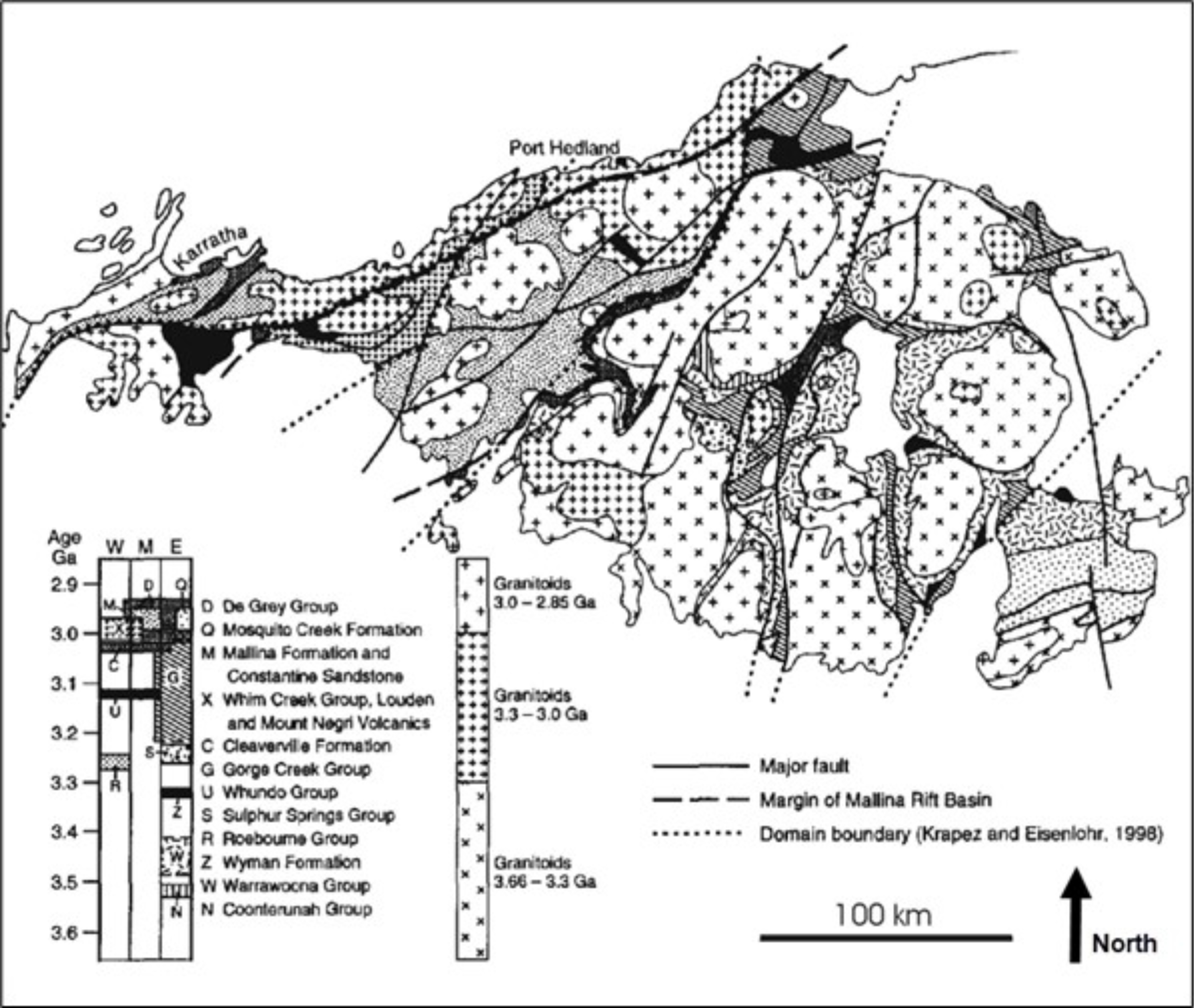
The Archean Pilbara Craton consists of large, domal, multiphase granitoid-gneiss complexes bordered by sinuous synformal to monoclinal greenstone belts (Hickman, 1983; Griffin, 1990; Barley, 1997). The greenstone belts range in age from approximately 3.56 to approximately 2.94 giga-annum (Ga), with the granitoids emplaced over a similar but slightly younger time span (e.g., Champion and Smithies, 1998). Although, the supracrustal rocks are structurally complex, the primary stratigraphic units may be correlated between greenstone belts (Hickman, 1983, 1990). The granitoid-greenstone terrane of the Pilbara Craton has been subdivided into tectonostratigraphic domains with boundaries defined by north northeast, south southwest (NNE-SSW) to northeast southwest (NE-SW) trending structural lineaments that regionally have a sinistral shear sense. The following lithotectonic units have been identified:
•East Pilbara granite-greenstone terrane
•Central Pilbara tectonic zone
•West Pilbara granite-greenstone terrane
At least seven episodes of granitic magmatism have been identified between 3.47 and 2.80 Ga. During this period, granitic magmatism became increasingly potassic and large ion lithophile element enriched, with increased compositional variability from tonalite-trondhjemite granodiorite to calc-alkaline and alkaline granite compositions due to cyclic crustal reworking and growth (Champion and Smithies, 1998). Most of the granitoid-gneiss complexes have tectonic margins, with little evidence of contact metamorphism of adjacent supracrustal sequences (Hickman, 1983). Granitic magmatism culminated with emplacement of a suite of 2.89 to 2.83 Ga granite plutons at (e.g., Blockley, 1980; Pidgeon, 1984; Bickle, et al., 1989; Smithies and Champion, 1998, 2001) and a 2.76 Ga suite of small A-type granites and stocks of tourmaline rich S-type peraluminous granites (Smithies and Champion, 1998). There is good spatial, geochemical, and geochronological evidence to link rare metal pegmatites in the Pilbara Craton with emplacement of the younger granite suite (e.g., Blockley, 1980; Kennedy, 1998; Kinny, 2000; Sweetapple, et al., 2000). Figure 6-1 shows the regional geology map.
| | | | | |
Wodgina_SK1300_Report_515800.040 | December 2022 |
SRK Consulting (U.S.), Inc.
| | | | | |
SEC Technical Report Summary – Wodgina | Page 26 |
 Source: Sweetapple, 2000
Figure 6-1: Regional Geology Map
6.1.2Local Geology
The property is located within the Wodgina Pegmatite District. This pegmatite district is entirely hosted in the eastern limb of the Wodgina greenstone belt along the southern portion of the Wodgina-Strelly lineament. This greenstone belt is a north-northeast plunging synform separating the Yule and Carlindi granitoid complexes within Central zone of the Pilbara Craton (Figure 6-1).
The Wodgina greenstone belt consists of mafic-ultramafic volcanics, sedimentary, and intrusive rocks, including ultramafic komatiites, mafic basalt, clastic sedimentary rocks, banded iron formation (BIF), and cherts. All rocks within the belt have undergone greenschist to lower amphibolite facies metamorphism at relatively low pressures (Sweetapple and Collins, 2002). A younger leucocratic granitoid of the Numbana Monzogranite is present on the eastern margins of the Wodgina greenstone belt.
Structurally, the Wodgina greenstone belt forms the core of a north-plunging synform. The Wodgina and Mt. Cassiterite deposits are located near the axis of the synform and near a left-lateral (sinistral) shear zone adjacent to the marginal leucocratic phase of the Numbana Monzogranite. It is
| | | | | |
Wodgina_SK1300_Report_515800.040 | December 2022 |
SRK Consulting (U.S.), Inc.
| | | | | |
SEC Technical Report Summary – Wodgina | Page 27 |
composed principally of interlayered mafic and ultramafic schists and amphibolite, with subordinate komatiite, clastic sediments, BIF and chert. The komatiitic and metasedimentary units within the Wodgina area are tentatively correlated to the Kunagunarrina and Leilira Formations respectively.
Archean volcanic activity and sedimentation was followed by the intrusion of Archean granitic batholiths with consequent deformation and metamorphism of the sequence. Late-stage granitic intrusions resulted in the emplacement of simple and complex pegmatite sills and barren quartz veins.
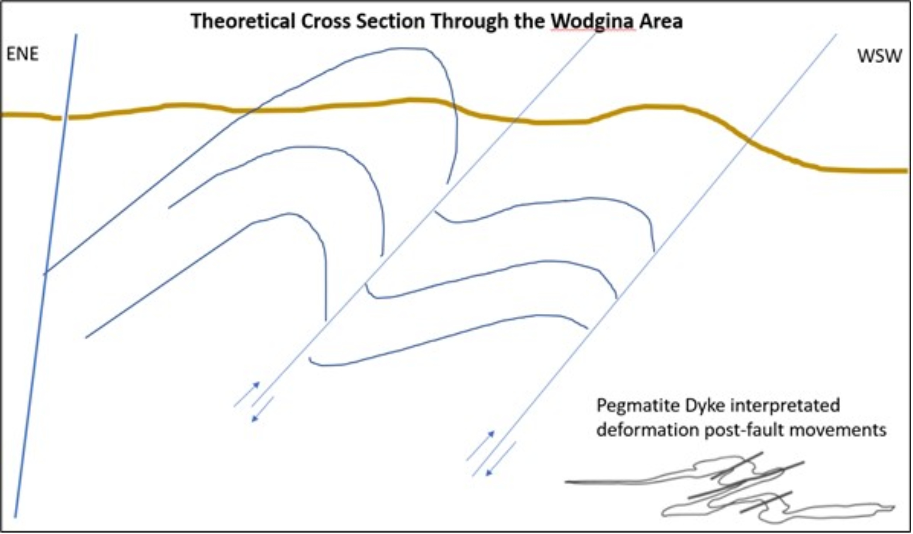
A major regional shear zone separates the two main pegmatite groups at Wodgina and Mt. Cassiterite. Both pegmatite groups have been emplaced syntectonically into fault/shear zones, with a predominantly reverse sense of movement. This emplacement has been related to a semi-concordant control of pegmatite distribution in both areas by F2 fold hinges and limbs. The Wodgina main lode pegmatite appears to be related to a major inclined fold hinge, while the pegmatites of the Mt. Cassiterite group appear to be sheets joined by a number of parasitic fold hinges.
| | | | | |
Wodgina_SK1300_Report_515800.040 | December 2022 |
SRK Consulting (U.S.), Inc.
| | | | | |
SEC Technical Report Summary – Wodgina | Page 28 |
Source: Sweetapple and Collins, 2002
Figure 6-2: Local Geology Map of the Wodgina Pegmatite District
| | | | | |
Wodgina_SK1300_Report_515800.040 | December 2022 |
SRK Consulting (U.S.), Inc.
| | | | | |
SEC Technical Report Summary – Wodgina | Page 29 |
6.1.3Property Geology
The property geology has been broken into two primary areas:
•The Cassiterite area containing the Mineral Resources of the Mt. Cassiterite Pit and the North Hill area
•The historic production area of the Wodgina pit located in the northern portion of the property.
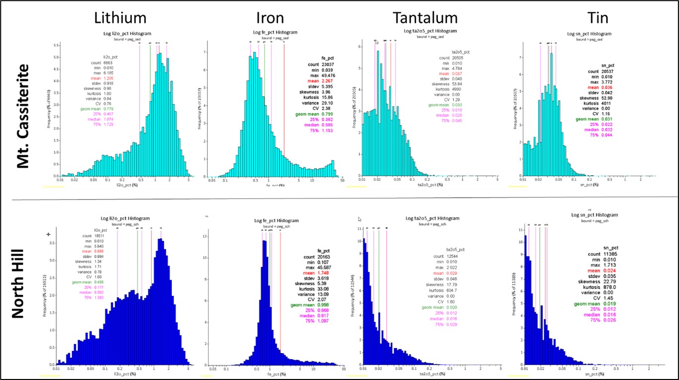
There are distinct differences in whole rock geochemistry between the two different pegmatite suites (Sweetapple and Collins, 1998) (Figure 6-2). The Wodgina pegmatite has a higher niobium: tantalum ratio than Mt. Cassiterite, which has a higher tin: tantalum ratio. These differences are reflected in the two different tantalum mineral suites in each pegmatite group. Significant differences were also noted in the gallium and beryllium contents, which were enriched and depleted respectively, in the Wodgina main lode pegmatite relative to the Mt. Cassiterite pegmatite group. The mineral assemblages in both pegmatite groups have undergone a significant degree of subsolidus recrystallisation (Sweetapple and Collins, 1998).
| | | | | |
Wodgina_SK1300_Report_515800.040 | December 2022 |
SRK Consulting (U.S.), Inc.
| | | | | |
SEC Technical Report Summary – Wodgina | Page 30 |
Source: Sweetapple, 2001
Figure 6-3: Wodgina Property Geology Map
Mt. Cassiterite Pegmatite Group
These pegmatites lie directly to the south of the Wodgina group and cover an area of approximately 1.1 by 0.8 km (Figure 6-4). They comprise a series of interlinked pegmatite sheets, dikes and irregular offshoot structures, and in contrast to the Wodgina group, have been emplaced within a thick formation of metasedimentary rocks, mostly composed of fine-grained psammite and thinly interbedded pelite with minor quartzite and chert (Sweetapple et al., 2001). Immediately north of the
| | | | | |
Wodgina_SK1300_Report_515800.040 | December 2022 |
SRK Consulting (U.S.), Inc.
| | | | | |
SEC Technical Report Summary – Wodgina | Page 31 |
Mt. Cassiterite pit, pegmatites have been intercepted from drilling hosted in amphibolite schist and generally display thicker individual pegmatite dikes with different chemistries than those observed and previously mined in the metasediments-hosted pegmatite sheets of the Mt. Cassiterite pit.
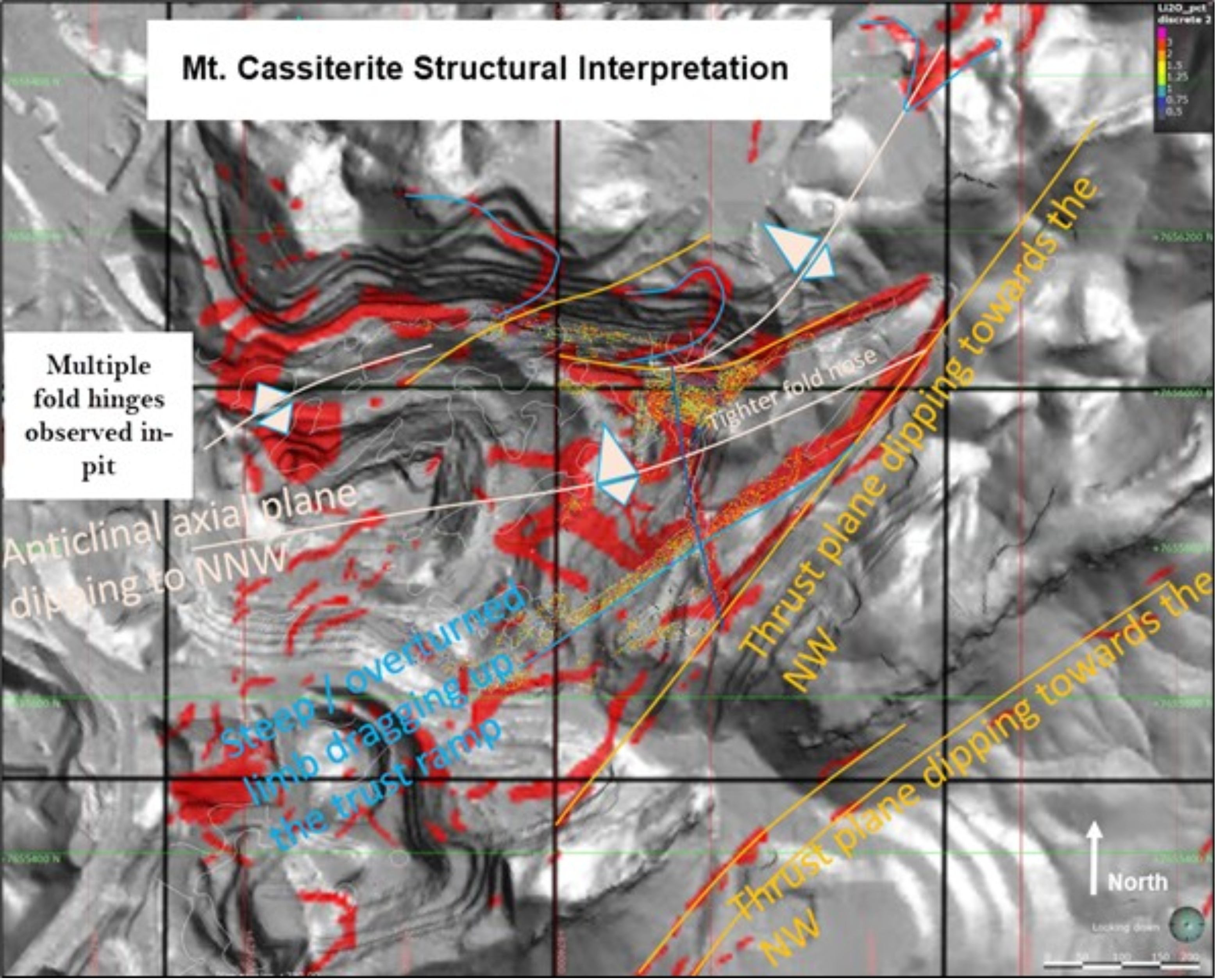
Within the Mt. Cassiterite pit, multiple sets of stacked pegmatite sheets occur, mostly 5 to 12 m thick, but ranging from 2 to 100 m and generally dipping 20 to 25°SE with localized 'roll-overs' dipping at 15 to 20°W to SW. These sheets are interconnected by near-vertical dikes that trend NW-SE and NE-SW, by irregular keel-like structures, and by thin stringers of pegmatite, all of which were emplaced at the same time. These pegmatite sheets were apparently syntectonically emplaced into a series of thrust faults that postdate at least two earlier deformation events identified by prominent cleavages and folding in the host metasedimentary rocks (Sweetapple and Collins, 2002).
Mount Cassiterite pegmatite appear to have a primary mineralogy and texture characteristic of albite-spodumene-type pegmatites, including an abundance of albite and primary spodumene with subordinate K feldspar and minor muscovite in near homogeneous sheeted bodies. The pegmatite sheets display a massive to comb-textured internal structure which Sweetapple and Collins (2002) regard as also being characteristic of albite-spodumene type pegmatites (Ginzburg and Lugovski, 1977; Cerny, 1992), with minor aplitic and K feldspar-rich layering.
These sheets are mostly unzoned, with a mineralogy dominated by megacrystic spodumene and perthitic microcline in a matrix of fine- to medium-grained quartz, albite and muscovite. Spodumene crystals are mostly aligned nearly perpendicular to the pegmatite contacts, typically exhibiting distinctive 'pull apart' structures. A weak zonation is evident as the development of finer grained border units, and occasional areas rich in microcline crystals.
Secondary assemblages, dominantly composed of fine-grained albite, variably overprint the assemblage outlined above in most areas of the pegmatite sheets. This alteration developed an accompanying pseudo-gneissic textured banding and syn-tectonic deformational textures. Cataclastic and proto-mylonitic textures are evident in places in the pegmatites. However, the micaceous minerals of the banding do not display a true schistosity, suggesting final crystallization of the pegmatite took place under hydrostatic stress conditions, after the termination of deformation association with emplacement (Sweetapple, 2000).
North Hill Pegmatite Group
These pegmatites lie directly to the north of the Mt. Cassiterite group under the area known locally as North Hill. Details on the mineralogy, chemistry, and association of these pegmatites is largely unknown but may represent a continuum of pegmatite emplacement between Mt. Cassiterite and the Wodgina Pegmatite Group to the north. This group has been identified through drilling in the North Hill area with various interpretations of the geometry and continuity over the years. Because no structural data to date has been collected in the area, the orientation is largely speculative.
The North Hill Pegmatite Group is hosted in a primary schist lithology, though logging varies greatly in the area. It is unknown whether the host lithology is complex, or the historic data is merely unreliable. This pegmatite group generally exhibits lower Li2O grades than in the Mt. Cassiterite area, along with displaying materially larger thicknesses than observed in the Mt. Cassiterite Pit. Internal pegmatite banding and mineralogy is largely unknown as evaluation and exploration activities in this Group have been conducted by reverse circulation (RC) drilling methods with analyses focused on chemistry and not mineralogy. Trace geochemistry of the North Hill Pegmatite Group varies from the
| | | | | |
Wodgina_SK1300_Report_515800.040 | December 2022 |
SRK Consulting (U.S.), Inc.
| | | | | |
SEC Technical Report Summary – Wodgina | Page 32 |
Mt. Cassiterite deposit located immediately to the south. It is inferred by MARBL that the primary Li mineralogy is spodumene. Although the general geochemistry of the area can be characterized by the current RC dominant drilling, deficiencies in the mineralogical characterization, metallurgical testwork, and other factors relevant to economic evaluations remain risks to the understanding of the viability of the pegmatites to support mining and processing in the North Hill area.
Wodgina Pegmatite Group
This group includes the Wodgina main lode pegmatite, plus several smaller pegmatites that are mostly subparallel to the main structure (Figure 6-3). They are characterized by an abundance of cleavelandite and/or sugary albite and are almost entirely hosted by variably foliated metakomatite. The Wodgina pit has historically exploited the Wodgina Main Lode pegmatite and associated secondary pegmatites for tantalum. The current economic focus on the property is for Li resources, whereas the Wodgina pegmatite group hosted Li as minor lepidolite and associated Li-bearing micaceous minerals.
The Wodgina main lode pegmatite is a sheeted dike that trends north-south, dips at 20 to 50° east (E), and cuts across the foliation of the host rock, which strikes north-south to NE-SW, and dips to the west. This pegmatite has a total strike length of approximately 1 km and varies from 5 to 40 m in thickness. However, most mining has been confined to the northern 500 m, where the pegmatite segments are thickest. Small offshoots of the pegmatite are subparallel to the foliation of the metakomatite host rocks.
The pegmatite postdates most of the deformation of the Wodgina greenstone belt and was apparently partially controlled by pre-existing folding and faulting. It is cut by late steeply dipping normal faults, while the northern end was disaggregated by later dip-slip faulting and late strike-slip shearing (Sweetapple et al., 2001). The northern portion of the pegmatite body has also been observed to be intruded around the hinge zone of an asymmetric fold, and its associated long limb (Sweetapple, 2000). While the pegmatite has a general easterly dip, it varies from a dike in the south, to a large bulbous mass with a saddle shape that pinches out rapidly into thin angular sheets in the north.
Although pegmatite zonation typical of highly fractionated pegmatites is not well developed in the Wodgina main lode, the zonation that is developed, takes the form of two main compositional assemblages in primary layers that subparallel contacts, as: i). layers of massive cleavelandite (a variety of albite) with rare quartz, spessartine and muscovite on both the footwall and hanging wall of the dike, and ii). a broad central unit of banded aplitic to granitic-textured medium to coarse grained albite-quartz-muscovite ±megacrystic perthitic microcline.
These assemblages are less regularly distributed on the northern end of the dike. The central bulbous section of the main dike contained a large irregular segregation of massive quartz up to 50 m wide and 60 m long. Ellis (1950) noted that the cleavelandite units appear to locally intrude the aplitic/granitic textured unit.
The marginal cleavelandite assemblage zones in the hanging wall and footwall are partially overprinted by a secondary fine-grained sugar-textured albite ±muscovite assemblage, and by lepidolite ±albite alteration of the micaceous aplitic-granitic textured unit. An intense 5 to 30 centimeter (cm) thick concentration of exomorphic mica was developed on the contacts with the wall
| | | | | |
Wodgina_SK1300_Report_515800.040 | December 2022 |
SRK Consulting (U.S.), Inc.
| | | | | |
SEC Technical Report Summary – Wodgina | Page 33 |
rocks (Sweetapple, 2000). Hall (1988) notes discrete units rich in beryl, spodumene and fluorite associated with these secondary overprints.
This tantalum mineralization is almost always within the massive cleavelandite units, commonly occurring in the core of radial aggregates of cleavelandite, and frequently as coarse skeletal-textured manganotantalite crystals clustered at the base of the hanging wall massive cleavelandite unit, suggesting precipitation and gravitational settling from that massive unit (Sweetapple, 2000).
The Wodgina main lode pegmatite is characterized by high-grade tantalum mineralization, and the presence of secondary lepidolite, or lithian muscovite, is consistent with it being an extremely fractionated pegmatite (Sweetapple et al., 2001). The primary cleavelandite and secondary albite units constitute approximately 78 vol.% of the pegmatite. The bulk composition of the pegmatite is more sodic and less silicic than most other rare metal pegmatites, consistent with the albite type of Cerny (1993). Other albite-enriched pegmatites close to the Wodgina main lode pegmatite are also considered to be of the albite type, as they have similar internal structure and modal mineralogy. Sweetapple and Collins (2002) suggest the low contents of rare alkali elements and volatile elements such as boron (B), Phosphorus (P), fluorine (F), and higher magnesium (Mg) and iron (Fe) values than other rare metal pegmatites are most likely to be the result of extensive ion exchange with the metakomatite wall rock. The same authors suggest it provide field evidence for the separation of a residual sodic melt enriched in lithophile elements escaping from crystallizing semi-consolidated albite-spodumene pegmatite sheets at Mount Cassiterite and appear to represent a regional zonation relationship.
6.2Mineral Deposit
The Mt. Cassiterite pegmatite group is classified as a rare element albite-spodumene type pegmatite. Spodumene (LiAlSi2O6) is the primary lithium-bearing mineral. It is massive to weakly layered pegmatite with comb-textured megacrystic microcline and spodumene with aplitic layers often displaying pseudo gneissic banding. Unlike many other Pilbara Craton pegmatite bodies, the Wodgina and Mt. Cassiterite pegmatites tend to not display internal structure such as mineralogical layering or banding. Lithium minerals are predominantly spodumene and lepidolite with secondary tin (Sn) in microlite, and manganese (Mn) in tantalite and columbite calciotantite. Other significant minerals include spessartine (Mn aluminosilicate garnet), elbaite (Na-Li alumino-boro-silicate tourmaline) and native Bi.
Geochronological work at the Wodgina deposit using various dating techniques (Rb-Sr, K-Ar, and Pb/Pb SHRIMP) provide pegmatite emplacement dates around 2,800 mega annum (Ma). This timing and other relationships suggest the likely source for the Wodgina pegmatites to be the Numbana Monzogranite.
The pegmatites at Wodgina have a semi concordant relationship to regional-scale parasitic folding (Sweetapple and Collins, 2002). Differences between the emplacement nature of the Wodgina and Mt. Cassiterite dykes appear to be controlled largely by the host rocks. The large discrete Wodgina “main lode” pegmatite is hosted in mafic-ultramafic sequence (metakomatite) compared to the smaller dike swarm at Mt. Cassiterite which is hosted within a metasedimentary (meta-arenite/psammite) sequence (Sweetapple, 2000). In addition to the main spodumene pegmatite dikes, smaller (less than 0.5 m thickness) veins and/or alternation of wall rock contain pegmatite-related
| | | | | |
Wodgina_SK1300_Report_515800.040 | December 2022 |
SRK Consulting (U.S.), Inc.
| | | | | |
SEC Technical Report Summary – Wodgina | Page 34 |
mineralogy of quartz-tourmaline-mica-albite-cassiterite. These secondary features often occupy parallel fractures adjacent to the main dike swarms.
At this time, individual pegmatites vary in strike length from approximately 200 m to 400 m. The thinner near surface pegmatites vary from 10 m to 30 m in thickness but vary locally from less than 2 m to up to 35 m thick. The massive basal pegmatite varies from 120 m to 200 m thick. The pegmatites intrude the mafic volcanic and meta-sedimentary host rocks of the surrounding greenstone belt.
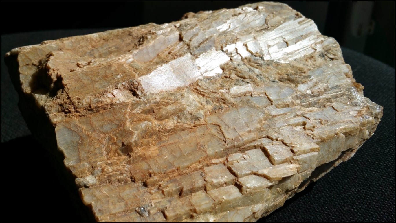
The lithium in the Cassiterite Pit and shallower pegmatites occurs as 10 to 30 cm long grey, white spodumene crystals within medium grained pegmatites comprising primarily of quartz, feldspar, spodumene and muscovite (Figure 6-4 and Figure 6-5). Typically, the spodumene crystals are oriented orthogonal to the pegmatite contacts. Some zoning of the pegmatites parallel to the contacts is observed, with higher concentrations of spodumene occurring close to the upper contact. In the massive basal pegmatite, the spodumene is distributed within fine-grained quartz, feldspar, spodumene and muscovite matrix.
Source: MRL, 2018
Figure 6-4: Wodgina Outcropping Pegmatite Example, Visible Spodumene Crystals
| | | | | |
Wodgina_SK1300_Report_515800.040 | December 2022 |
SRK Consulting (U.S.), Inc.
| | | | | |
SEC Technical Report Summary – Wodgina | Page 35 |
Source: MRL, 2018
Figure 6-5: Wodgina Pegmatite Grey White Spodumene Crystals (Specimen Around 30 cm Long)
6.3Stratigraphic Column and Local Geology Cross-Section
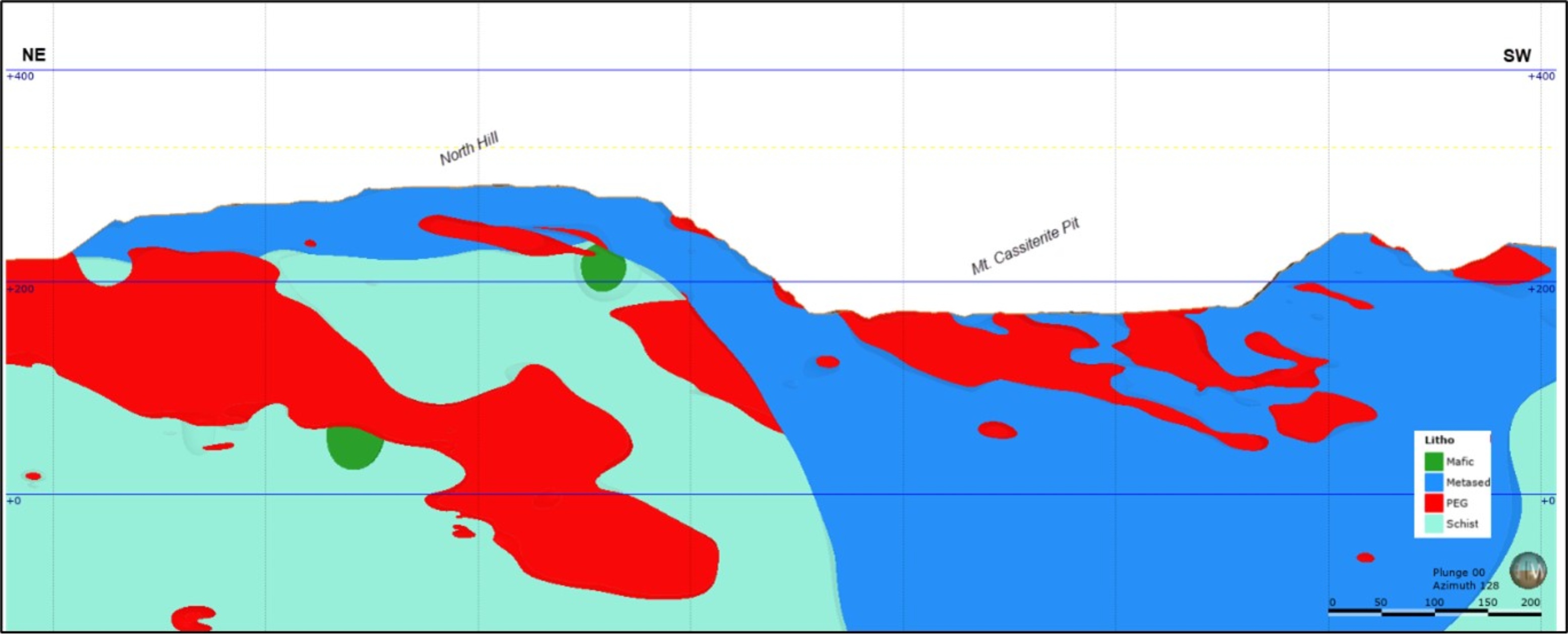
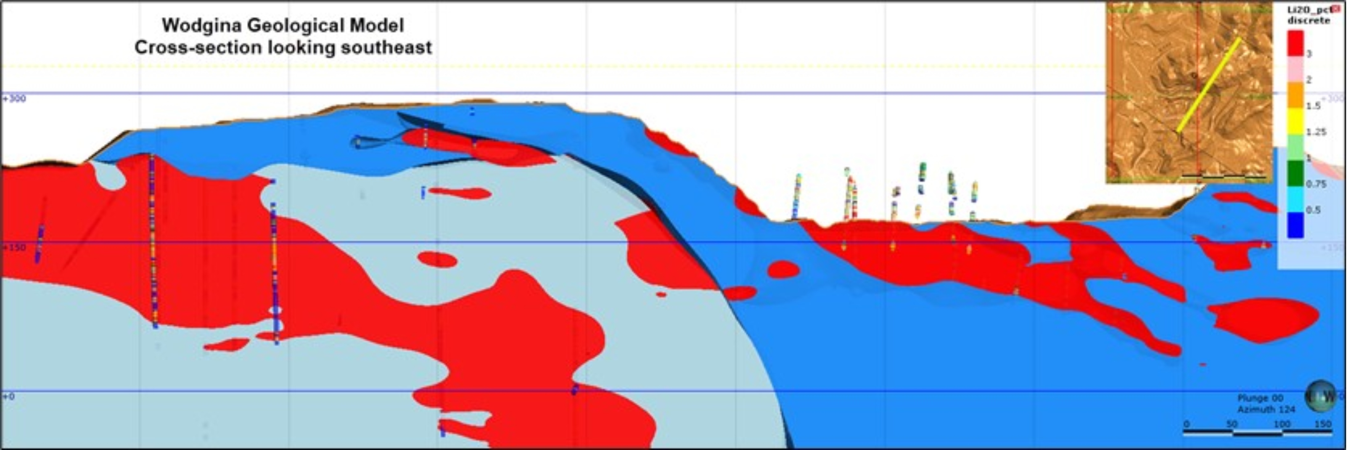
Figure 6-6 shows a generalized long-section of the North Hill - Mt. Cassiterite area containing the extents of Mineral Resources on the property. The long section shows the transition from amphibolite schist-hosted Li-pegmatites to metasedimentary-hosted Li-pegmatites in the Mt. Cassiterite Pit area.
Source: SRK, 2020
Figure 6-6: Long-Section from Northeast to Southwest across the Main Portion of the Deposit
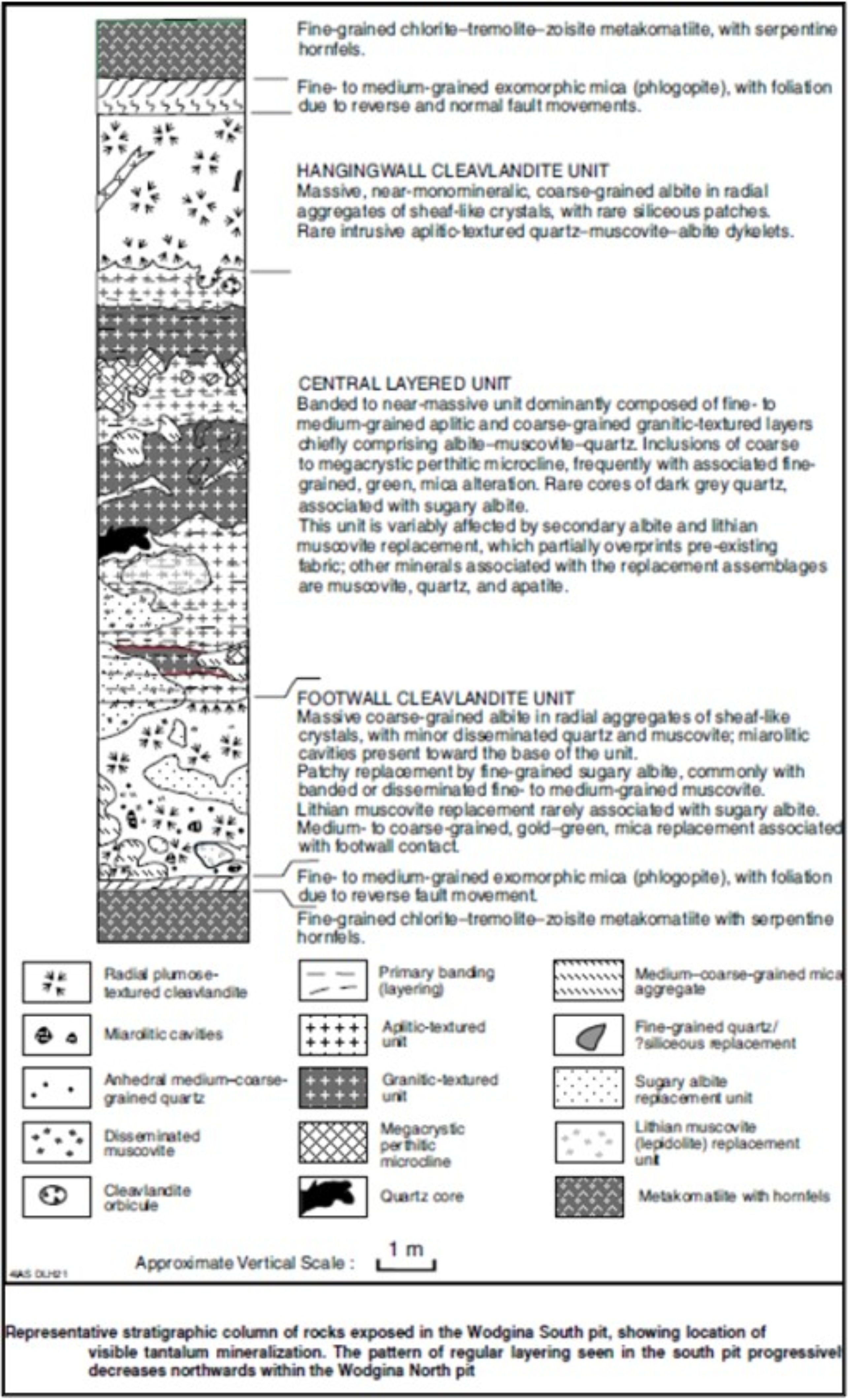
Figure 6-7 and Figure 6-8 illustrate a typical stratigraphic column through the Mt. Cassiterite pit area and an individual pegmatite dike respectively.
| | | | | |
Wodgina_SK1300_Report_515800.040 | December 2022 |
SRK Consulting (U.S.), Inc.
| | | | | |
SEC Technical Report Summary – Wodgina | Page 36 |
Source: Sweetapple, 2001
Figure 6-7: Generalized Stratigraphic Column from the Mt. Cassiterite Pit
| | | | | |
Wodgina_SK1300_Report_515800.040 | December 2022 |
SRK Consulting (U.S.), Inc.
| | | | | |
SEC Technical Report Summary – Wodgina | Page 37 |
Source: Sweetapple, et al., 2017
Figure 6-8: Generalized Stratigraphic Column Through Mt. Cassiterite Pegmatite Dyke
| | | | | |
Wodgina_SK1300_Report_515800.040 | December 2022 |
SRK Consulting (U.S.), Inc.
| | | | | |
SEC Technical Report Summary – Wodgina | Page 38 |
7Exploration
7.1Exploration Work (Other Than Drilling)
All exploration work is currently performed via drilling. SRK is not aware of additional surveys (geochemical, geophysical, etc.) which have been performed over the Wodgina site by or on behalf of the registrant.
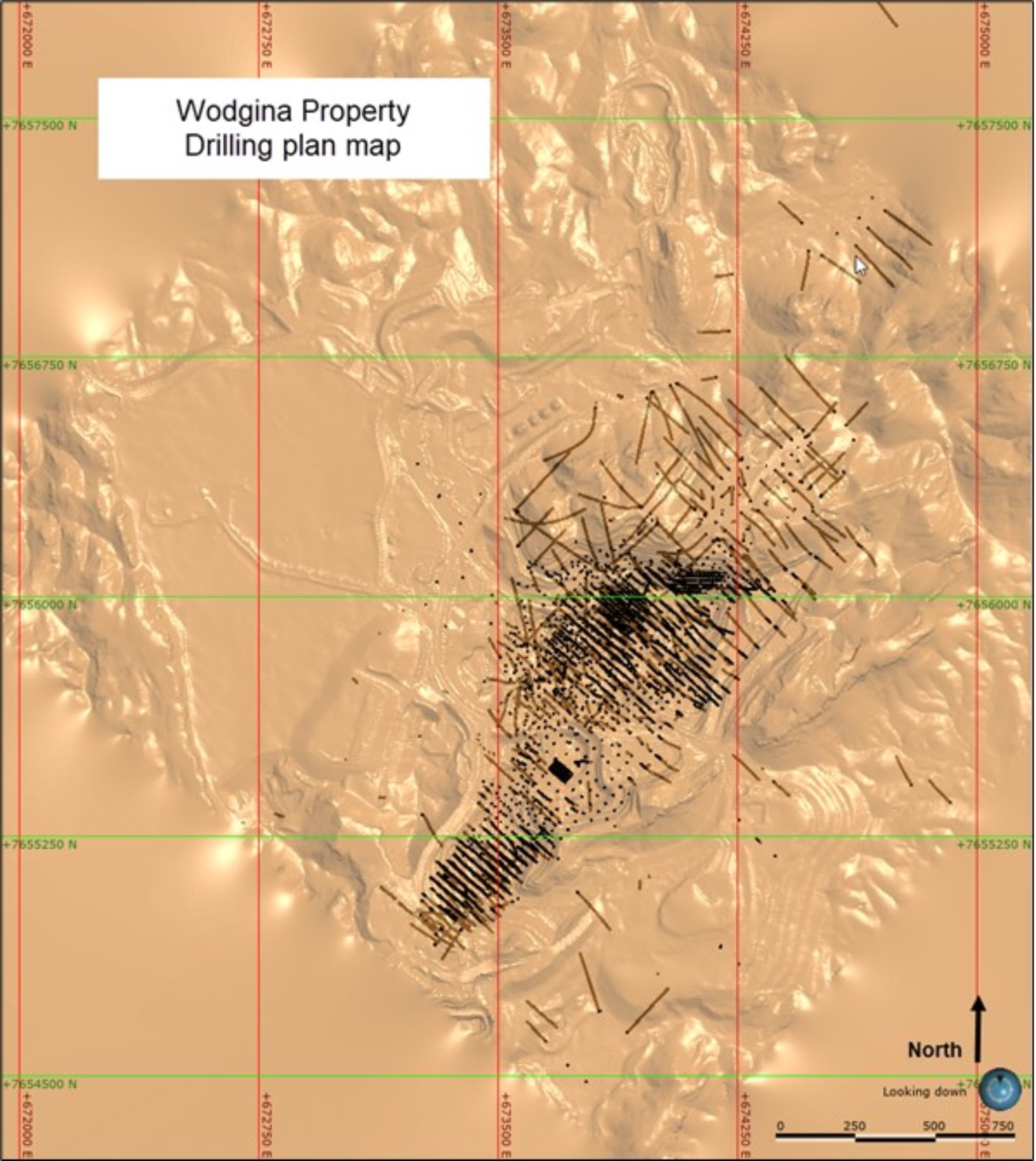
7.2Exploration Drilling
Exploration drilling which is utilized in the geological interpretation and MRE is summarized in the sub-sections below. Considering the history of exploration on the property, there are numerous drillholes pre-1990 that are not utilized as part of any Mineral Resource determination and lack detailed descriptions or documentation, which have been excluded from this report.
7.2.1Drilling Type and Extent
Drilling at the Wodgina property has historically been dominated by RC drilling methods. In addition to RC, both diamond drilling (DDH) and rotary air-blast (RAB) methods have been utilized in a limited capacity for specific purposes such as preliminary exploration, metallurgical, or geotechnical data collections.
Drilling in the Mt. Cassiterite area has been carried out by a number of drilling contractors and by a variety of different methods over the years. Drilling carried out by the Pan West JV included 3,825 m of air track: 1,145 m of RC drilling and 204 m of DDH.
Under GAM, who operated the property in the late 1990s, six development-drilling programs have been completed at the Mt. Cassiterite pit. The first, in 1996, involved a track mounted RC rig completing a 3,464 m drilling program, a resource extension program during 1998 to 99 comprised 17,586 m of RC drilling and 2,225 m of DDH, a further resource extension program in 2001 comprised 18,694 m of RC drilling, A RC infill-drilling program in Mt. Tinstone area commenced in February 2002 and totaled 5,432 m, further resource drilling was conducted in 2002/03 consisting of 12,805 m of RC drilling. As a result of this program, an infill-drilling program was carried out which targeted the East Ridge mining area, totaling 2,948 m.
Additional resource drilling, completed in March 2004, consisted of 3,866 m of RC drilling and later infill drilling for a total of 12,930 m. The 2004 drill campaign was designed to extend the resource to the south of Mt Tinstone, as well as determine the extent of the pegmatite sheets adjacent to the old Wodgina Pit, north of the Mt. Cassiterite mining area. This drilling was conducted by a track-mounted RC drill rig and consisted of 3,866 m. The drilling to the south of Mt Tinstone highlighted a significant extension of the Mt Tinstone pegmatite sheets and was subsequently infill-drilled by two drill rigs (wheel and track-mounted) for a total of 12,930 m.
Concurrent with this drilling, an infill-drilling program was also being carried out in the Mt. Cassiterite area aimed at better defining the nature of the pegmatite sheets. This drilling consisted of 8,984 m.
In 2005, further RC drilling was undertaken to determine the limits of the South Tinstone pegmatite to the south, as well as systematically infill the main Mt. Cassiterite area to achieve at least a 25 m by 25 m pattern. Selected areas within the Mt. Cassiterite area were drilled to 25 m by 12.5 m to provide data for an assessment of the effects of closer spaced drilling. This drilling included 8,458 m of
| | | | | |
Wodgina_SK1300_Report_515800.040 | December 2022 |
SRK Consulting (U.S.), Inc.
| | | | | |
SEC Technical Report Summary – Wodgina | Page 39 |
wheel-mounted RC drilling in Mt. Cassiterite and 2,220 m in South Tinstone. In addition to this, 1,017.5 m and 382.7 m of DDH was conducted in the Mt. Cassiterite and Tinstone areas respectively. The drilling allowed further detail to be placed on the pegmatite physical geology model. The resultant model was used as the basis of an optimization study to allow a revised pit design and schedule to be produced.
A two-staged RC drilling program was undertaken between July and October of 2006. The first stage was aimed at completing the 25 by 25 m grid-based grade control drilling, targeting the deeper portions of the resources that lay within the pit designs associated with the 2006 optimization study. The second stage involved scout resource evaluation of the known extensions to resources outside and down dip of the resources inside the pit design. A total of 7,898 m was drilled from 86 holes. The drilling allowed for the updating and refinement of the 2006 physical geology model of the deposit, as well as further spatial grade definition within the pegmatite sequence. The refinement was the basis of the 2007 MRE. The second stage exploratory RC drilling program consisted of 1,138 m drilled from five holes.
A small metallurgical and geotechnical focused DDH program was completed in 2006 in the Mt. Cassiterite and Mt Tinstone pits and totalled 1,518.7 m of HQ3 core.
In 2008, an infill RC drilling program was carried out in the Mt Tinstone and Mt. Cassiterite pits. The total program involved 1,914 m of drilling for 47 holes and was planned to target gaps in geological understanding at relatively shallow depths (less than 80 m) relevant to the pit floor level development, up until the mine was placed on care and maintenance. The program was based within the resource models of the Mt Tinstone and Mt. Cassiterite areas.
| | | | | |
Wodgina_SK1300_Report_515800.040 | December 2022 |
SRK Consulting (U.S.), Inc.
| | | | | |
SEC Technical Report Summary – Wodgina | Page 40 |
Source: GAM, 2010
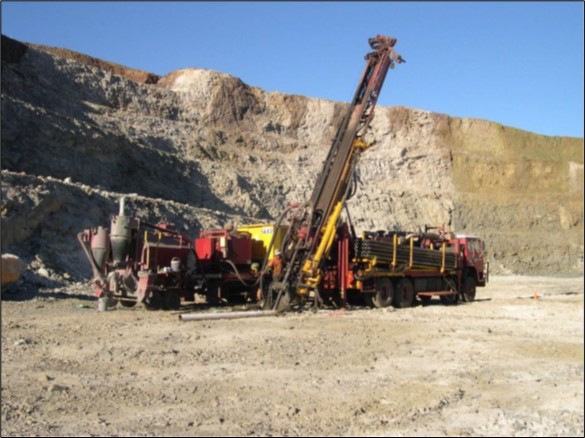
Figure 7-1: Mt. Magnet Drilling Hydro 150 Drilling RC in the Mt. Cassiterite Pit (During 2008)
August and September of 2010 saw the completion of a further RC infill drilling program, with the intent of improving the understanding of the spatial dispersion and grades of the pegmatites in the resource model between the mine grid sections 20400N to 20800N of the Mt. Cassiterite pit. The general strategy of the program is to provide an improved reconciliation of tonnes and grade for future mining in this area. In all, 27 RC holes were drilled for a total of 2,024 m.
After the property was acquired by MARBL, a RC drilling program of 245 holes was conducted between September 2016 and July 2017 for a total of 61,825 m. MRL directed RC drilling was carried out using a face sampling hammer and a 142 mm diameter bit. Blast hole drilling was carried out with Atlas Copco BH rigs using a 140 mm diameter bit. No additional resource drilling has been completed on the property since 2018.
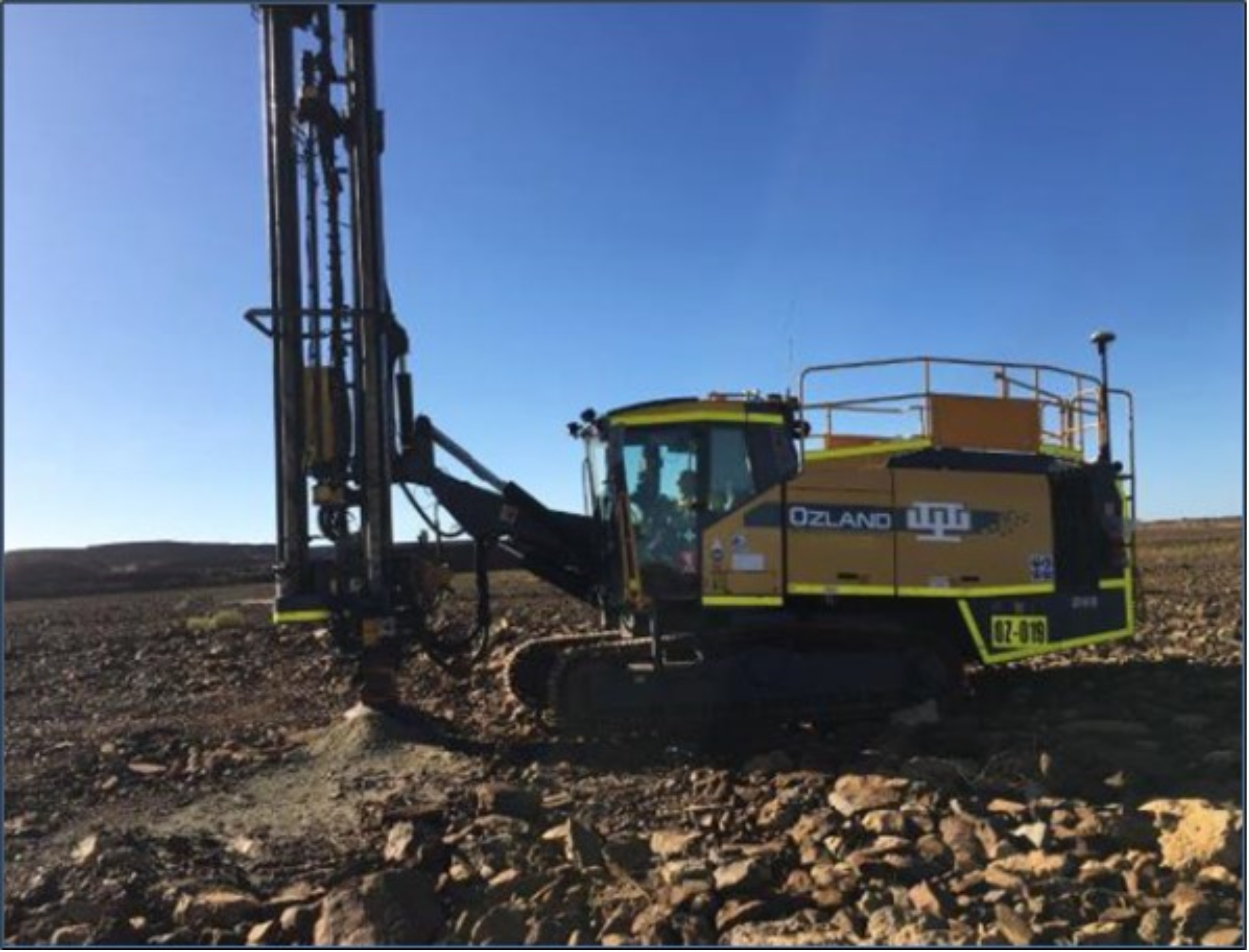
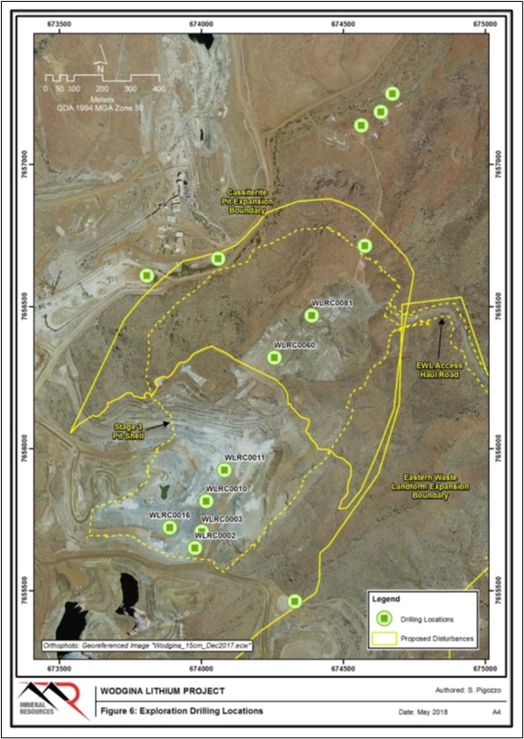
During 2018, MRL conducted a shallow drill program to assess potential resources in the tailings storage facilities (TSF). The TSF’s have been drilled on a nominal 50 m by 50 m pattern with an Open Hole Percussion Atlas Copco D65 drill rig (Figure 7-2). Hole diameter is nominally 165 mm. While this program has previously been utilized in disclosing Mineral Resources in the TSF (MRL, 2019), SRK notes that the lack of metallurgical testwork provided precludes definition of this material as a Mineral Resource herein.
| | | | | |
Wodgina_SK1300_Report_515800.040 | December 2022 |
SRK Consulting (U.S.), Inc.
| | | | | |
SEC Technical Report Summary – Wodgina | Page 41 |
Source: Widenbar and Associates, 2018
Figure 7-2: Atlas Copco D65 Drill Rig
Table 7-1: Recent Drilling Campaigns on the Wodgina Property
| | | | | | | | | | | |
| Year | Type | Length (m) | Areas |
| 1996 | RC | 3,464 | Mt. Cassiterite |
| 1998 | RC | 17,586 | Mt. Cassiterite |
| 1998 | DDH | 2,225 | Mt. Cassiterite |
| 2002 | RC | 5,432 | Tinstone |
| 2002 | RC | 12,805 | Tinstone and Mt. Cassiterite |
| 2002 | RC | 2,948 | Mt. Cassiterite |
| 2004 | RC | 3,866 | Mt. Cassiterite |
| 2006 | RC | 7,898 | Mt. Cassiterite |
| 2008 | RC | 1,914 | Tinstone and Mt. Cassiterite |
| 2010 | RC | 2,024 | Mt. Cassiterite |
| 2016 | RC | 61,825 | Mt. Cassiterite |
Source: Widenbar, 2018
| | | | | |
Wodgina_SK1300_Report_515800.040 | December 2022 |
SRK Consulting (U.S.), Inc.
| | | | | |
SEC Technical Report Summary – Wodgina | Page 42 |
Collar and Downhole Survey
Historic collar locations were surveyed by a differential global positioning system (dGPS) which achieves an accuracy of ± 0.01 m. All down-hole survey data was converted to Wodgina Mine Grid and corrected for magnetic declination. The grid system is MGA Zone 51 (GDA94) for horizontal data and AHD (based on AusGeoid09) for vertical data.
For pre-2008 RC drilling programs, down-hole surveying was conducted using a single shot Eastman down-hole camera, equipped with a “high-dip‟ compass for all vertical holes. For diamond holes, survey shots were taken every 20 m and at the end of hole. The RC holes had camera shots taken at either 40 m or 50 m intervals, as well as at the end of hole. All camera shots were taken inside the 6 m stainless steel starter rod.
For the 2010 and 2012 RC drilling, all except for a few collapsed holes were gyro surveyed to compare the data. Gyro-derived data was recorded at the surface and 5 m intervals down-hole to the end of the hole. Ultimately, the gyro-surveyed data was accepted as the most-accurate of the down-hole surveys and this data was adopted into the database to project the drillhole strings.
During the 2017 and 2018 drilling program, all except for a few collapsed holes were surveyed using a north-seeking gyro survey tool. Gyro-derived data was recorded at the surface and random intervals down-hole to the end of the hole. Reflex North seeking (NS) gyros were used to survey both vertical and inclined drillholes. Ultimately, the NS gyro-surveyed data was accepted as the most-accurate of the down-hole surveys and this data was adopted into the database. Drillhole collars were surveyed by MRL Wodgina mine surveyor on a campaign basis using RTK dGPS.
7.2.2Drilling, Sampling, or Recovery Factors
Pre-2016, Li2O data on the Wodgina property was obtained from re-analysis of historic samples and rejects stored onsite. Drilling, sampling, and analyses were originally focused on tantalum resources prior to 2016.
Prior to 2008, RC chip samples were collected at 1 m intervals and split with a riffle splitter. RC samples were split with a cone splitter after 2008, to produce a sub-sample of 3 to 5 kilograms (kg) for analysis. Sieved chips from the RC drilling were logged geologically at 1 m intervals, with information recorded including lithology, color, mineralogy, grain size, texture, alteration, structure, weathering and hardness. Sample condition and recovery also were noted for each metre. Chips were collected in pre-numbered chip trays and after logging, stored in exploration sea container at Wodgina mine site.
Similar to RC chips, diamond core was logged geologically at 1 m intervals except the lithological boundaries. Lithology, color, mineralogy, grain size, texture, alteration, structure, weathering and hardness were noted, furthermore diamond core was orientated and logged for geotechnical qualities, core recovery, RQD, fractures count per m, and structures were recorded. Sampled core was photographed (dry and wet) and weighted for density calculation.
Samples have also been collected from the MRL drilling campaign conducted between July 2016 and August 2018. An RC rig-mounted cone splitter was used, with samples falling through an inverted cone splitter, splitting the sample into a 90/10 ratio. A 10% off-split is retained in a calico bag. The 90% split residue is stored on ground. All pegmatite intercepts were sampled at 1 m intervals plus 2 m of adjacent waste was sent for laboratory analysis.
| | | | | |
Wodgina_SK1300_Report_515800.040 | December 2022 |
SRK Consulting (U.S.), Inc.
| | | | | |
SEC Technical Report Summary – Wodgina | Page 43 |
Historic sample recoveries are near 100% in the pegmatite, sample loss mainly occurs in shear zones and occasionally on contacts. Most loss is recorded at the start of holes, near collars. MRL recoveries are almost all logged as 80%. There is a low probability of preferential loss of sample having an effect on the grade of pegmatites. RC recoveries are recorded as a percentage based on visual and weight estimates of the sample.
When moist or wet ground conditions were experienced in historic drilling, the cyclone was washed out between each sample and run further to ensure no inter-sample contamination. The rig had a dust collection system that involved the injection of water into the sample pipe before the sample reached the cyclone. This water injection prevented fines from being lost out of the top of the cyclone. This system was employed to minimize dust fines being released into the atmosphere in the work area and to minimize the possibility of the sample being positively biased by the loss of the lighter minerals such as quartz, feldspar, and mica, thus effectively concentrating the heavier ore minerals such as tantalite.
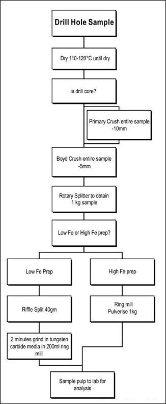
RC chips were dried at 100°C. All samples below approximately 4 kg were totally pulverized in LM5’s to nominally 85% passing a 75-micron (μm) screen. The few samples generated above 4 kg were crushed to less than 6 mm and riffle split first prior to pulverization.
Drill core samples are also collected sequentially in pre-numbered sample bags after cutting with a diamond saw. The integrity and continuity of the core string is maintained by reassembling the core in the tray. If any apparent geological discontinuities are noted within or at the end of core runs these are resolved by the logging geologist.
All HQ3 core pegmatite intercepts were quartered lengthwise using a diamond core-saw, with one quarter of the core for the pegmatite intercepts sent for XRF analysis. Selected intervals of most of the pegmatite intercepts (in the HQ3 core) were then sampled (as half-core) for metallurgical analysis.
All NQ2 core was geologically logged and split lengthwise into half core using a diamond core-saw, with half core samples sent for XRF analysis.
All diamond drill core assay samples were taken at regular 1 m intervals or at smaller intervals to conform to logged pegmatite contacts.
Commercially prepared certified reference materials (CRM) were inserted amongst the drill samples.
MRL 2018 Drill report:
A nominal 2 kg to 3 kg RC sample was collected for each metre. Samples were collected using a static cone splitter mounted below the cyclone; the material falling through the cone splitter was split in 90/10 ratio. 10% off-split was retained in a pre-numbered calico bag with the remaining residue collected in buckets and dumped on the ground in sequence adjacent to the hole.
All pegmatite intercepts were sampled at 1m intervals along with 2 m into the footwall and hangingwall of adjacent waste and delivered to the NAGROM Laboratory in Perth for analysis; samples outside the pegmatite except adjacent waste were not assayed.
After geological login of a NQ core a sample spread sheet was created with the sample intervals. 1m intervals in pegmatite zones adjusted by lithological contacts on footwall and hanging wall plus approximately 2 m of waste on each side were sampled. The core was cut in half, put in pre-
| | | | | |
Wodgina_SK1300_Report_515800.040 | December 2022 |
SRK Consulting (U.S.), Inc.
| | | | | |
SEC Technical Report Summary – Wodgina | Page 44 |
numbered calico bags and delivered to the NAGROM Laboratory in Perth for analysis; samples outside the pegmatite except adjacent waste were not assayed.
Widenbar 2017
In March-April 2016, a program was instituted to retrieve as many RC pulp samples as possible from storage at Wodgina and re-assay the pegmatite zones for Li2O%. Li2O has been assayed by ICP005 at Nagrom Laboratories.
GAM 2013
Sample preparation is routinely undertaken at the Wodgina onsite laboratory. Received samples less than 2 kg are rejected and extra sample material (if available) is routinely requested.
Samples are oven dried, weighed, crushed to -5 mm, with a rotary split 1 kg then pulverized to -100 micron and a final 100 g split passed to assay preparation (Figure 7-3).
A 3 g sample measured by electronic scale is submitted using LODIL protocol with high grade samples (0.75 g) rerun using PEAKA protocol.
As far as can be determined since 2006, all samples have been assayed by XRF for a consistent 36 elements at either the Wodgina or Greenbushes laboratory.
| | | | | |
Wodgina_SK1300_Report_515800.040 | December 2022 |
SRK Consulting (U.S.), Inc.
| | | | | |
SEC Technical Report Summary – Wodgina | Page 45 |
Source: Dolbear, 2012
Figure 7-3: GAM Sample Preparation Flow Sheet.
| | | | | |
Wodgina_SK1300_Report_515800.040 | December 2022 |
SRK Consulting (U.S.), Inc.
| | | | | |
SEC Technical Report Summary – Wodgina | Page 46 |
7.2.3Drilling Results and Interpretation
Individual drilling results are not presented herein in tabulated format. Extensive drilling exists across the property. Summary Mineral Resources are disclosed, which represent the overall deposit interpretation and are entirely informed on the basis of the drilling.
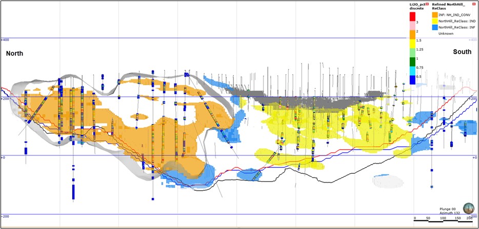 Source: SRK, 2021
Figure 7-4: Eastward Looking Longitudinal Section of the Cassiterite Deposit Showing Classification.
7.3Hydrogeology
SRK has summarized the current perspective on hydrogeology from MRL’s provided reports on the Wodgina area.
The Wodgina area is a fractured rock environment, with groundwater resources being associated with bedrock aquifers including major fault systems, fractured rocks and well-developed weathering profiles (Burton, 2018).
Zones of brittle deformation develop enhanced porosity and permeability, and can receive, store and transmit water. Areas of relatively unfractured bedrock dominate the sub-surface and form boundaries to the water resources stored in fractured zones.
Minor aquifers also occur in localized alluvium and colluvium in drainage lines and, in some areas, may support groundwater dependent vegetation (e.g., along the Turner River). These aquifers are thin, readily drained and have limited storage capacity. they host the water table near the drainage lines and drain vertically into underlying fractured rock aquifers.
The retention of runoff water in the alluvial aquifers from intense rainfall events forms an important recharge mechanism for the fractured rock aquifers as the hydroperiod (i.e., the period of saturation) for the streams and alluvial aquifers is likely to directly affect the quantity of recharge available to the fractured rock aquifer (Burton, 2018).
| | | | | |
Wodgina_SK1300_Report_515800.040 | December 2022 |
SRK Consulting (U.S.), Inc.
| | | | | |
SEC Technical Report Summary – Wodgina | Page 47 |
Borefields used for water supply at Wodgina target fractured quartz veins (Old and North borefields) and contact zones between ultramafics, quartzites and conglomerate (Breccia borefield) (Burton, 2018). All three borefields develop fractured rock aquifers and the most reliably and higher yielding bores are associated with deeper fractured zone intersections (Burton, 2018).
Various hydrogeological studies and groundwater monitoring have been undertaken in the Wodgina area over the past two decades:
Hydrogeological studies to date have focused on the identification and management of either: (a) groundwater resources to support mining operations; or (b) groundwater levels to inform decisions on potential dewatering of iron ore deposits.
Groundwater monitoring has been undertaken in accordance with Western Australian Department of Water and Environmental Regulation (DWER) license conditions e.g., TSFs (most recently TSF3), the eastern waste landform (EWL), borefields (Old, North and Breccia) and the wastewater treatment plant.
Depth to groundwater varies considerably across the Wodgina area as a result of major faulting and fractured rock aquifers being interspersed with impermeable bedrock. This is evidenced by recent exploration drilling undertaken by MARBL within and adjacent to Cassiterite Pit.
The locations of holes where water was recorded during recent drilling activities are shown in Figure 7-5.
| | | | | |
Wodgina_SK1300_Report_515800.040 | December 2022 |
SRK Consulting (U.S.), Inc.
| | | | | |
SEC Technical Report Summary – Wodgina | Page 48 |
Source: MRL, 2018
Figure 7-5: Drillhole Locations of Noted Groundwater
| | | | | |
Wodgina_SK1300_Report_515800.040 | December 2022 |
SRK Consulting (U.S.), Inc.
| | | | | |
SEC Technical Report Summary – Wodgina | Page 49 |
Five of these holes (WLRC0002, WLRC0003, WLRC00010, WLRC00011, WLRC00016) shown in Figure 7-5, are located within the active mining area, and the recorded depth to water varies from 3 to 142 meters below ground level (mBGL). This places the water table elevation between 197 mAHD and 93.5 mAHD.
Two of these holes (WRLC0081, WRLC0060) are located to the northeast of the active mining area, and the recorded depths of water in these holes are 70 mBGL and 254 mBGL, respectively. These holes are 200 m apart with water table elevations varying between 200 mAHD and 35m AHD.
The current pit floor elevation of Cassiterite Pit is 140 mAHD. The pit floor is dry except for a small area of water accumulation at the eastern end of the pit floor. Where groundwater has been found in the pit, the relatively minor quantities of water are easily removed by the installation of a sump and pumping of water ex-pit. Currently this water is stored in the Tinstone pit where it is evaporated.
To the southwest of Cassiterite Pit, Tinstone and South Tinstone pits contain pit lakes that are understood to be associated with interflow rather than groundwater inflow (AECOM, 2011). The bases of these two pits are both approximately 210 mAHD.
To the north of TSF3, data from monitoring bores indicates that the water table occurs at approximately 13 m below ground level. The corresponding water table elevation in this area is approximately 217 mAHD.
Groundwater monitoring is undertaken at Wodgina in association with the borefields, TSFs, EWL, and wastewater treatment plant (WWTP).
A series of monitoring bores were previously installed around the toe of the Eastern Waste Landform. These monitoring bores, similarly, to the TSF bores, require monthly reporting on water levels and quarterly reporting on ambient groundwater quality, and will continue to be monitored for any analytical signs that acid production is occurring within the waste landform.
Groundwater data for the EWL monitoring bores is only in its infancy for WLPL, monitoring has only taken place since September 2017. Locations of groundwater monitoring bores are shown in Figure 7-6.
| | | | | |
Wodgina_SK1300_Report_515800.040 | December 2022 |
SRK Consulting (U.S.), Inc.
| | | | | |
SEC Technical Report Summary – Wodgina | Page 50 |
Source: MRL, 2018
Figure 7-6: Groundwater Monitoring Locations.
| | | | | |
Wodgina_SK1300_Report_515800.040 | December 2022 |
SRK Consulting (U.S.), Inc.
| | | | | |
SEC Technical Report Summary – Wodgina | Page 51 |
7.4Geotechnical Data, Testing and Analysis
As the majority of drilling at Wodgina is conducted using RC methods, geotechnical data and analyses have been primarily conducted based on the existing open pit via pit mapping and observations by third party consultants. Two geotechnical drillholes have been completed: DGET0604 and -0605 in the Mt. Cassiterite pit though their positions are considered sub-optimal for rock mass conditions and intersecting major structures. Numerous geotechnical mapping and structural data collection campaigns haven been completed in the 2000s. Data collected and utilized in pit design analyses include stereo plot and pit structural data.
Pells Sullivan Meynink (PSM), engineering consultants out of West Perth, WA have provided a recent geotechnical review which is summarized in this section. The PSM report summarized observations from pit inspections including key pit hazards as illustrated in Figure 7-7.
SRK notes all geotechnical data is based on pit mapping with no drilling, analytical or laboratory tests due to the general use of RC drilling methods on the property.
Source: PSM, 2017
Figure 7-7: Pit Geotechnical Hazards
7.5Property Plan View
The plan view of the property is presented in Figure 7-8. This figure illustrates the Property topography and locations of drillholes.
| | | | | |
Wodgina_SK1300_Report_515800.040 | December 2022 |
SRK Consulting (U.S.), Inc.
| | | | | |
SEC Technical Report Summary – Wodgina | Page 52 |
Source: SRK, 2020
Figure 7-8: Plan Map of the Wodgina Property Showing All Drillhole Traces
7.6Exploration Target
Exploration potential exists withing the Wodgina deposit as defined. These have been drill-tested as previously described. SRK is not aware of additional exploration targets that are relevant to the Wodgina deposit.
| | | | | |
Wodgina_SK1300_Report_515800.040 | December 2022 |
SRK Consulting (U.S.), Inc.
| | | | | |
SEC Technical Report Summary – Wodgina | Page 53 |
8Sample Preparation, Analysis and Security
8.1Sample Preparation, Assaying and Analytical Procedures
Sample preparation is completed at the Wodgina site. RC drill chips were dried at 100°C. All samples below approximately 4 kg were totally pulverised in LM5’s to nominally 85% passing a 75 μm screen. Samples generated above 4 kg were crushed to less than 6 mm and riffle split first prior to pulverization. Samples are then dried at 105°C, crushing and splitting through a riffle splitter for samples greater than 2.5 kg. In this case, samples are all approximately 200 g, so samples are simply sorted, dried, and pulverized to P80 at 75 µm.
Analytical testing is performed using a combination of inductively coupled plasma (ICP) and X-ray fluorescence (XRF) by Nagrom Laboratories of Kelmscott, WA. Nagrom Labs is an independent laboratory with no affiliation with the Wodgina property or MARBL Table 8-1 below presents analyzed elements, units, and detection limits.
Table 8-1: Elements, Units and Detection Limits for Analyses Conducted by NAGROM Laboratory
| | | | | | | | | | | |
| Element | Method | Units | Detection Limit |
Li2O | ICP005 | ppm | 10 |
Al2O3 | XRF007 | % | 0.001 |
| CaO | XRF007 | % | 0.001 |
Cr2O3 | XRF007 | % | 0.001 |
| Fe | XRF007 | % | 0.001 |
K2O | XRF007 | % | 0.001 |
| MgO | XRF007 | % | 0.001 |
| MnO | XRF007 | % | 0.001 |
Na2O | XRF007 | % | 0.001 |
| P | XRF007 | % | 0.001 |
| S | XRF007 | % | 0.001 |
SiO2 | XRF007 | % | 0.001 |
TiO2 | XRF007 | % | 0.001 |
V2O5 | XRF007 | % | 0.001 |
Ta2O5 | XRF007 | % | 0.001 |
Nb2O5 | XRF007 | % | 0.001 |
| Sn | XRF007 | % | 0.001 |
| LOI1000 | TGA002 | % | 0.01 |
| Rb | ICP005 | ppm | 1 |
| Cs | ICP005 | ppm | 1 |
Source: MRL, 2018
Lithium had not been analyzed for the Wodgina site prior to 2016, as the operation was previously focused on the production of tantalum. The majority of Li2O data that is used in the Mineral Resource calculation has been obtained from the re-assay of historic pulps supplemented with RC and DDH drilling in 2018. SRK notes the potential for sample degradation of historic pulps. Despite this risk, any hydration or alteration of pulps is considered minimal due to the pulps being stored in watertight sea containers onsite. SRK has not inspected the sample storage or monitored the sample submission process.
| | | | | |
Wodgina_SK1300_Report_515800.040 | December 2022 |
SRK Consulting (U.S.), Inc.
| | | | | |
SEC Technical Report Summary – Wodgina | Page 54 |
The site is security-controlled by MRL with all samples stored on-site. Digital data is maintained by MRL.
8.2Quality Control Procedures/Quality Assurance
Field duplicates from RC drilling were collected from the second sample port of the cone splitter, for diamond tails another half of the sampled core was used, at a rate of 1:20; (sample numbers ending in 00, 20, 40, 60, and 80 were assigned as duplicates) however, only field duplicates within the interval determined to be sampled at 1 m intervals (nominally the pegmatite intersection plus 2 m either side) were submitted for assaying. The vast majority of field duplicates, which were assayed, are from within the pegmatite intervals. Certified standard samples were inserted for RC/DDH by the supervising geologist at the rate of two standards per 100 samples (2%). SRK notes duplicates are inserted at a frequency consistent with industry standards while insertion of CRMs is considered well below acceptable QC standards along with no blanks used as part of the overall QA/QC program.
Widenbar (2018) described the QA/QC program as follows:
The original RC pulps were subject to stringent QA/QC and laboratory preparation procedures and are considered reliable for the purposes for which they are being used.
Two standards were initially submitted at the rate of approximately 1 in 11 samples, and internal laboratory repeats, and splits have been assayed at a rate of 1 in 10. Recent MRL QA/QC protocols used for the RC drill samples included the insertion of one of three types of CRMs at an incidence of 1 in 36, and the repeat analysis of field duplicate samples at an incidence of 1 in 20. Lab protocols included duplicate analysis at an incidence of 1 in 20 and pulp repeat analysis at an incidence of 1 in 20.
Five CRM standards were utilized as part of the QC program in 2018. Performance charts are provided for key elements. CRM performance varied summarized at:
•High grade AMISO339 showed a high bias for Li2O (%) and minor increasing trend for Fe2O3 from analyses
•Moderate grade AMISO340 showed a low bias for Li2O (%) and high bias for Fe2O3 (%) from analyses
| | | | | |
Wodgina_SK1300_Report_515800.040 | December 2022 |
SRK Consulting (U.S.), Inc.
| | | | | |
SEC Technical Report Summary – Wodgina | Page 55 |
Source: MRL, 2021
Figure 8-1: CRM AMISO339 Control Performance Chart - Li2O (%)
| | | | | |
Wodgina_SK1300_Report_515800.040 | December 2022 |
SRK Consulting (U.S.), Inc.
| | | | | |
SEC Technical Report Summary – Wodgina | Page 56 |
Source: MRL, 2021
Figure 8-2: CRM AMISO340 Control Performance Chart - Li2O (%)
| | | | | |
Wodgina_SK1300_Report_515800.040 | December 2022 |
SRK Consulting (U.S.), Inc.
| | | | | |
SEC Technical Report Summary – Wodgina | Page 57 |
Source: MRL, 2021
Figure 8-3: CRM AMISO343 Control Performance Chart - Li2O (%)
Prior to MARBL taking ownership of the property in 2016, all analyses and QC were conducted using a combination of the Wodgina and Greenbushes laboratories with QC samples incorporating standards, repeats, duplicates and split samples but no blanks. One in twenty samples are riffle split in the laboratory and a split created which is analyzed along with the original sample.
As an extension of the quality control procedures, when operational, the Wodgina laboratory periodically participate in "round robin" exercises whereby samples are randomly selected and assayed by the Wodgina laboratory, Greenbushes laboratory and one or two other commercial laboratories. The results from each laboratory are compiled and compared.
SRK notes that QA/QC documentation does not exist prior to 2013. Therefore, all analytical data obtained prior to 2013 is considered to have a lower confidence due to the inability to track, manage, and mitigate potential issues and errors associated with preparation and analysis.
8.3Opinion on Adequacy
It is the opinion of SRK that, based on documentation, the original sampling was performed in a reasonable manner consistent with industry standards. The analytical data that forms the basis of the Mineral Resource was primarily sourced from sample rejects collected during tin/tantalum exploration drilling across the property, further supported by focused lithium drilling in 2018. Based on a review of the data and historic documentation, it is the opinion of SRK that the fundamental data is adequate for the reporting of Mineral Resources with the various factors related to data confidence being considered during classification.
| | | | | |
Wodgina_SK1300_Report_515800.040 | December 2022 |
SRK Consulting (U.S.), Inc.
| | | | | |
SEC Technical Report Summary – Wodgina | Page 58 |
It is SRK’s opinion that utilizing historic metallurgical recovery data (as discussed in Section 10) from production is adequate for the disclosure of Mineral Resources in the Mt. Cassiterite area. However, the lack of metallurgical testing, mineralogy, and analyses on the property increases the risk of predictive recovery which is key for Mineral Reserve estimation. Further work is required before confidence in this modifying factor is adequate for disclosure of Mineral Reserves.
8.4Non-Conventional Industry Practice
The analytical data for the assessment of the Wodgina property’s Mineral Resources does not include any non-conventional testing. All analyses were performed using industry standard procedures and testing by a combination of independent laboratory for Li2O and an internal + external labs for historic data.
| | | | | |
Wodgina_SK1300_Report_515800.040 | December 2022 |
SRK Consulting (U.S.), Inc.
| | | | | |
SEC Technical Report Summary – Wodgina | Page 59 |
9Data Verification
9.1Data Verification Procedures
SRK performed a variety of data validation and verification procedures to assess the quality of underlying data associated with the Wodgina property. Procedures include:
•Check of database against assay certificates
•Visual validation of logging and analytical data in relation to historic models
•Statistical validation of analytical data
9.2Limitations
SRK reviewed 37,534 unique samples from laboratory assay certificates from MRL during August 2020 for comparison to the drillhole database. The following items represent findings from the validation of all received assay certificates.
•There are 34,552 unique samples in the drillhole assay database compared to 37,534 in the laboratory certificates. The discrepancy is due to drilling data outside the Mt. Cassiterite block model area of interest.
•SRK was able to successfully match 28,640 assay certificates to the drillhole assay database.
•5,912 samples in the drillhole assay database do not have certificates.
•Each sample in the assay database has 18 values (columns or elements) resulting in a total of 515,520 (18 x 28,640) possible value matches between the certificate files and the assay database. SRK was able to match 513,363 values between the certificate files representing an error rate of 0.4%.
•No collar or downhole survey verification was conducted.
•No independent duplicate analytical work was conducted.
SRK notes use of historic drilling data in the Mineral Resource calculation which contain a variety of uncertainties. These related to a lack of QA/QC on historic analytical data, lack of collar and downhole survey on historic drilling, a variety of logging, and a historic lack of focus on Li2O requiring pulp re-assay for a portion of the database.
9.3Opinion on Data Adequacy
It is SRK’s opinion that the database is acceptable for use in determining Mineral Resources with the variety of identified potential concerns being accounted for in resource classification. Further recommendations on future drilling and analyses are presented in section 23 under Recommendations.
| | | | | |
Wodgina_SK1300_Report_515800.040 | December 2022 |
SRK Consulting (U.S.), Inc.
| | | | | |
SEC Technical Report Summary – Wodgina | Page 60 |
10Mineral Processing and Metallurgical Testing
There are limited metallurgical analyses from drilling in the Mt. Cassiterite pit and there is no data in the North Hill area of the Wodgina property. SRK notes that MARBL operated the Mt. Cassiterite pit for lithium production from 2016 through 2019 thus demonstrating metallurgical recovery from mining areas. For the purposes of this report, a 65% metallurgical recovery has been applied based on historic processing averages from mining in the Mt. Cassiterite pit (pers. comm, MRL, 2020).
The lack of mineral processing and metallurgical testing in the North Hill area is accounted for in Mineral Resource classification. There is no metallurgical testing from samples obtained from the TSF, and SRK has not conducted a MRE for this disclosure. MRL has previously disclosed mineral resources for the TSF in their JORC code disclosure.
It is SRK’s opinion that utilizing historic metallurgical recovery data from production is adequate for the disclosure of Mineral Resources in the Mt. Cassiterite area. However, the lack of metallurgical testing, mineralogy, and analyses on the property increases the risk of predictive recovery, which is key for Mineral Reserve estimation. Further work is required before confidence in this modifying factor is adequate for disclosure of Mineral Reserves.
| | | | | |
Wodgina_SK1300_Report_515800.040 | December 2022 |
SRK Consulting (U.S.), Inc.
| | | | | |
SEC Technical Report Summary – Wodgina | Page 61 |
11Mineral Resource Estimates
11.1Geological Modelling
SRK completed an updated geological model based on general lithology and structural data obtained from MARBL in September 2020, supplemented with publicly available reports and maps. The previous geological model was completed by Widenbar & Associates in October 2018 (Widenbar, 2018) and included 3D wireframe modeling of pegmatite based on drilling interpretation and historic sheet-like dike assumptions.
The 2020 SRK geological model incorporated regional and local lithology with historic structural mapping to provide an updated interpretation of the pegmatite geometry and include pegmatite dike host lithology which is believed to materially affect the mineralogy, chemistry, and rheology of the dikes. The MARBL-provided drilling database was reviewed with logging codes grouped into broad lithotypes for modeling purposes. The large variety of recent and historic drilling was grouped into the following lithology codes:
•Overburden and fill material
•TSF – tailings storage facility fills from historic processing
•Saprolite
•Mafic dikes
•Pegmatite dike
•Metasedimentary units
•Schist
•Mafic volcanics
•Banded iron formation (BIF)
•Granitoid intrusives
SRK noted that historic drilling and logging showed inconsistency in both codes and interpretation requiring the broad grouping of lithotypes. SRK grouped logging codes based on documentation to provide a reasonable basis for 3D modeling, but it is possible that these could be refined or reinterpreted. It is SRK’s opinion that additional work should be performed to improve the lithotype grouping and domaining that may require re-interpretation of historic logging.
Using Leapfrog Geo software, the grouped lithologies were modeled in 3D accounting for mapped regional faulting and folding. The interpretation is primarily based on regional and local geological mapping by the GSWA and internal documents of previous operators. Multiple fault-bound geological sub-models were generated incorporating the Tinstone Pit, Mt. Cassiterite Pit, and North Hill areas due to the distinct individual nature of rock types and structural boundaries. A plan view of the lithostratigraphic model is shown in Figure 11-1.
| | | | | |
Wodgina_SK1300_Report_515800.040 | December 2022 |
SRK Consulting (U.S.), Inc.
| | | | | |
SEC Technical Report Summary – Wodgina | Page 62 |
Source: SRK, 2020
Figure 11-1: Plan View Map of the Wodgina Lithology Model (Overburden and Fill Removed)
11.2Adequacy of Data and Non-Conventional Industry Practice
11.2.1Structural Interpretation and Modeling
The structural interpretation of the Wodgina area was updated as part of the 2020 modelling process due to a general lack of structural modeling in previous work. Historically, a shallowly dipping pegmatite swarm was interpreted in the Mt. Cassiterite area based on limited historic pit mapping. Reviewing historic GSWA mapping (Figure 11-2), the presence of drag folding, thrust faulting, and the regional synclinal form was largely ignored in this interpretation. Therefore, an updated conceptual model (Figure 11-3) was required to account for local in-pit complexity, offsetting mapped dikes, and the changing geometry of dikes hosted within the schist domain of North Hill compared to the metasedimentary host observed in the Mt. Cassiterite Pit. Based on the various data provided by
| | | | | |
Wodgina_SK1300_Report_515800.040 | December 2022 |
SRK Consulting (U.S.), Inc.
| | | | | |
SEC Technical Report Summary – Wodgina | Page 63 |
MARBL and public information, SRK generated an updated structural interpretation (Figure 11-4) for use in the 2020 geological model update. A simplified cross section from NNE to SSW (Figure 11-5) shows how the nature of pegmatite emplacement and geometry is affected based on host lithology between the North Hill area and the Mt. Cassiterite pit.
Source: Blockely, 1980 – annotated by SRK, 2020
Figure 11-2: Regional Structural Geology Interpretation
| | | | | |
Wodgina_SK1300_Report_515800.040 | December 2022 |
SRK Consulting (U.S.), Inc.
| | | | | |
SEC Technical Report Summary – Wodgina | Page 64 |
Source: SRK, 2020
Figure 11-3: Schematic Structural Cross Section in the Wodgina Area
| | | | | |
Wodgina_SK1300_Report_515800.040 | December 2022 |
SRK Consulting (U.S.), Inc.
| | | | | |
SEC Technical Report Summary – Wodgina | Page 65 |
Source: SRK, 2020
Figure 11-4: Mt. Cassiterite Pit Structural Interpretation
| | | | | |
Wodgina_SK1300_Report_515800.040 | December 2022 |
SRK Consulting (U.S.), Inc.
| | | | | |
SEC Technical Report Summary – Wodgina | Page 66 |
Source: SRK, 2020
Figure 11-5: Cross Section of Wodgina Geological Model
| | | | | |
Wodgina_SK1300_Report_515800.040 | December 2022 |
SRK Consulting (U.S.), Inc.
| | | | | |
SEC Technical Report Summary – Wodgina | Page 67 |
SRK modeled the pegmatite dike domains as separate volumes based on geological interpretations and the differing nature of the pegmatite geometry between the metasedimentary and schist hosted dikes. The differences between the metasedimentary and schist hosted includes the following observations:
•Thin and consistently high Li2O grades within metasedimentary hosted dikes compared to thicker and more variable Li2O grades in schist-hosted dikes.
•Variable chemistries noted in the pegmatites between the two host rocks.
The differences in chemical variability are illustrated in Figure 11-6. Reviewing key elements of Li, Fe, Ta, and Sn show material differences in mean and population distributions suggesting chemical interaction and influence of the host rocks in relation to the pegmatite dyke chemistry. SRK notes that traditional trace chemistry used for pegmatite characterization include Be, Cs, and Rb are absent from the MARBL database.
Source: SRK, 2020
Figure 11-6: Differing Elemental Behavior between the Mt. Cassiterite and North Hill Areas
11.3Key Assumptions, Parameters, and Methods Used
The Key assumptions, parameters and methods used to estimate the quality and quantity of Mineral Resources are outlined in the following sections. SRK utilized industry standard techniques including data compositing, reviewed the potential for capping of high yield samples, performed exploratory data analysis (EDA) including determining spatial continuity of key economic variables to provide insight into search and estimation parameters.
| | | | | |
Wodgina_SK1300_Report_515800.040 | December 2022 |
SRK Consulting (U.S.), Inc.
| | | | | |
SEC Technical Report Summary – Wodgina | Page 68 |
11.3.1Compositing
A composite length analysis (CLA) was performed to evaluate implications for various compositing methods and lengths. Due to the mean and median sample length for RC and DDH being approximately 1 m, a 1 m composite using run-length methodology was selected. Composited samples were broken by major lithology including the two dominant pegmatite domains of PEG_schist and PEG_metased. Figure 11-7 shows original and composited data lengths.
Source: SRK, 2020
Figure 11-7: Histograms of (L) Log Raw Sample Length and (R) Composite Length
11.3.2Capping
A high yield capping analysis was performed on Li2O values within intervals logged as pegmatite. Though minor lithium-bearing minerals are known to be present in the host rock as an alteration halo associated with the emplaced pegmatite dikes, the mineralogy is unknown, and from personal communications with Albemarle staff familiar with the deposit, these altered zones do not contain mineralization of interest. Therefore, no other domains of potential lithium-bearing minerals were analyzed for capping.
With the logged pegmatite units, SRK reviewed potential capping in both the PEG_metased and PEG_schist domains to understand potential differences in high-yield or outlier values. Both domains appear equivalent in regard to potential outliers with the highest composited pegmatite lithium values being 6.19%. The highest yield values between 5.1 and 6.19% Li2O have been capped at 5.1% Li2O to reduce the influence for these high-yield samples. High yield caps applied by domain are shown in Table 11-2.
| | | | | |
Wodgina_SK1300_Report_515800.040 | December 2022 |
SRK Consulting (U.S.), Inc.
| | | | | |
SEC Technical Report Summary – Wodgina | Page 69 |
Source: SRK, 2020
Figure 11-8: Log Probability for Li2O in Pegmatites
11.3.3Exploratory Data Analysis
EDA was calculated for the major mineralized domains and for primary and secondary variables with economic interest. Summary descriptive statistics were calculated by domain including a variety of graphics including box & whisker plots, histograms, and bivariate statistics.
| | | | | |
Wodgina_SK1300_Report_515800.040 | December 2022 |
SRK Consulting (U.S.), Inc.
| | | | | |
SEC Technical Report Summary – Wodgina | Page 70 |
Table 11-1: Summary Descriptive Statistics by Logged Lithology Type
Source: SRK, 2020
| | | | | |
Wodgina_SK1300_Report_515800.040 | December 2022 |
SRK Consulting (U.S.), Inc.
| | | | | |
SEC Technical Report Summary – Wodgina | Page 71 |
Source: SRK, 2020
Figure 11-9: Box and Whisker Plots for Li2O for (L) all Lithologies and (R) Pegmatite Domains
| | | | | |
Wodgina_SK1300_Report_515800.040 | December 2022 |
SRK Consulting (U.S.), Inc.
| | | | | |
SEC Technical Report Summary – Wodgina | Page 72 |
Source: SRK, 2020
Figure 11-10: Histogram of Li2O Distribution for (L) Schist-Hosted and (R) Metasediment-Hosted Pegmatites
11.3.4Spatial Continuity
The spatial continuity was determined by calculating semi-variograms for key economic variables by domain. Variograms were calculated per domain for the metasedimentary and schist domains which contain the majority of Li2O mineralization on the property. The west mafic volcanic block utilized the spatial continuity data from the schist domain while Tinstone domain used variography from the metasedimentary domain. These two domains are deemed of secondary importance and contain limited data to generate reliable variograms.
The following figures provide the modeled variography for Li2O and Fe as the primary economic variables in the Wodgina deposit.
| | | | | |
Wodgina_SK1300_Report_515800.040 | December 2022 |
SRK Consulting (U.S.), Inc.
| | | | | |
SEC Technical Report Summary – Wodgina | Page 73 |
Source: SRK, 2020
Figure 11-11: Modelled Semi-Variogram for Li2O in the Metasedimentary Domain
Source: SRK, 2020
Figure 11-12: Modelled Semi-Variogram for Li2O in the Schist Domain
| | | | | |
Wodgina_SK1300_Report_515800.040 | December 2022 |
SRK Consulting (U.S.), Inc.
| | | | | |
SEC Technical Report Summary – Wodgina | Page 74 |
Source: SRK, 2020
Figure 11-13: Modelled Semi-Variogram for Fe in the Metasedimentary Domain
Source: SRK, 2020
Figure 11-14: Modelled Semi-Variogram for Fe in the Schist Domain
The interpretations of spatial continuity between the two major domains show similar nugget effects but materially different ranges for Li2O between the two separate host rock types of the pegmatite dykes. The metasedimentary hosted pegmatites show longer ranges with more gradual variance when compared to the schist-hosted pegmatites in the North Hill area.
Iron variability shows similar yet inverse ranges in pegmatites hosted in the two primary rock types. In the metasedimentary hosted pegmatites of the Mount Cassiterite area show near omni-directional behavior with relatively short ranges of continuity while Fe in the schist-hosted pegmatites of the North Hill area show materially longer ranges of continuity. The Fe nugget effect in the schist domain is relatively higher compared to the metasedimentary-hosted pegmatites.
| | | | | |
Wodgina_SK1300_Report_515800.040 | December 2022 |
SRK Consulting (U.S.), Inc.
| | | | | |
SEC Technical Report Summary – Wodgina | Page 75 |
11.3.5Estimation and Search Neighborhood
Resource estimation was performed in Leapfrog Geo and Maptek’s Vulcan software. Grade interpolation is based on hard boundaries within the pegmatite lithology broken down into two separate domains based on host lithology type. Estimation methodology is a combination of Ordinary Kriging (OK) and inverse distance weighting (IDW). Additionally, a nearest neighbor (NN) estimate was performed for validation purposes only.
A multi-pass method of estimation was utilized to aid in classification determination with each pass increasing the search size while reducing the limitations on number of samples and drillholes. The result has each block coded by which pass was used for estimation thus aiding in visualizing block volumes of increased confidence in the first and second passes compared to the larger and more relaxed criteria of the third pass.
The search neighborhood was selected based on modeled variogram interpretations, iterative processes of search criteria variation, and the resulting output OK quality estimates for Kriging efficiency (KE) and slope of regression (SoR).
| | | | | |
Wodgina_SK1300_Report_515800.040 | December 2022 |
SRK Consulting (U.S.), Inc.
| | | | | |
SEC Technical Report Summary – Wodgina | Page 76 |
Table 11-2: Variography Parameters for the 2020 Resource Block Model.
| | | | | | | | | | | | | | | | | | | | | | | | | | | | | | | | | | | | | | | | | |
| Variable | Domain | Pass | Variable Orientation | Estimation Method | Ellipsoid | Samples | Octants | Outlier Restrictions | Block Discretization |
| Major | Semi-Major | Minor | Min | Max | Max per DH |
Li2O | Metased | 1 | yes | OK | 80 | 70 | 20 | 4 | 10 | 3 | No | None | 5,5,5 |
Li2O | Metased | 2 | yes | OK | 150 | 150 | 40 | 3 | 10 | 2 | No | None | 5,5,5 |
Li2O | Metased | 3 | yes | IDW2 | 300 | 300 | 50 | 3 | 8 | 2 | No | None | 5,5,5 |
Li2O | Schist | 1 | yes | OK | 100 | 100 | 20 | 4 | 10 | 3 | No | 5.1 | 5,5,5 |
Li2O | Schist | 2 | yes | OK | 175 | 175 | 40 | 3 | 10 | 2 | No | 5.1 | 5,5,5 |
Li2O | Schist | 3 | yes | IDW2 | 300 | 300 | 50 | 3 | 10 | 2 | No | None | 5,5,5 |
Li2O | Tinstone | 1 | yes | OK | 100 | 100 | 20 | 4 | 10 | 2 | No | None | 5,5,5 |
Li2O | Tinstone | 2 | yes | OK | 200 | 200 | 40 | 3 | 10 | 2 | No | None | 5,5,5 |
Li2O | Tinstone | 3 | no | OK | 300 | 300 | 60 | 3 | 8 | 2 | No | None | 5,5,5 |
Li2O | West Mafic | 1 | yes | OK | 100 | 100 | 20 | 4 | 10 | 3 | No | 5.1 | 5,5,5 |
Li2O | West Mafic | 2 | yes | OK | 175 | 175 | 40 | 3 | 10 | 2 | No | 5.1 | 5,5,5 |
Li2O | West Mafic | 3 | yes | IDW2 | 300 | 300 | 50 | 3 | 8 | 2 | No | None | 5,5,5 |
Source: SRK, 2020
| | | | | |
Wodgina_SK1300_Report_515800.040 | December 2022 |
SRK Consulting (U.S.), Inc.
| | | | | |
SEC Technical Report Summary – Wodgina | Page 77 |
Secondary elements were estimated in the pegmatite domain but not used for the economic evaluation of the project. These secondary elements include: As, K2O, Na2O, S, and Ta2O5. Though not directly utilized for Mineral Resource determination, these elements may be considered useful for other aspects of the Wodgina operation.
Each secondary element was estimated using composited drilling data in the same manner as Li2O and Fe. Estimation was into the hard domain of pegmatite by host lithology. The estimation criteria for each secondary element are the same:
•IDW squared was used as the estimation method
•A search ellipsoid of 300 m by 300 m by 75 m was used
•A minimum of four samples and a maximum of eight samples with a maximum of two composites per drillhole was used
•SRK used variable anisotropy based on the same pegmatite sub-domain as Li2O and Fe
Bulk density was coded into the resource block model based on host lithology of the domain. Table 11-3 provides the bulk density value assigned to each lithology.
Table 11-3: Assigned Bulk Density in Resource Block Model
| | | | | | | | |
| Lithology Type | Sub-Domain | Bulk Density |
| pegmatite | Mt. Cassiterite area | 2.73 |
| pegmatite | North Hill area | 2.80 |
| pegmatite | Mafic volcanics | 2.73 |
| schist | n/a | 2.96 |
| metasediments | n/a | 2.96 |
| mafic volcanics | n/a | 2.96 |
Source: SRK, 2021
11.4Reasonable Prospects for Economic Extraction
The CoG used is 0.5% Li2O, which is based on historic CoG assumptions.
An economic pit shell was used to constrain Mineral Resource classification. The parameters used for construction of the economic pit shell include:
•Price: US$583.85/t of 6% concentrate
•Processing and G&A Costs: US$23/t of processed mineralized material
•Mining Cost: US$2.85/t moved base mining cost (from elevation 300) and US$0.03/t moved incremental cost per 10m bench
•Mass Yield Equation: (Li2O% * met recov) / 6
◦Li2O% lithium grade
◦Metallurgical recovery = 65%
◦Concentrate grade: 6%
SRK notes that economic assumptions used in the determination of the CoG and economic pit shell are based on a combination of historic data provided by MARBL and current trends in the lithium market. A more detailed market study and contractual pricing is planned for future refinements to the economic assumptions at Wodgina.
| | | | | |
Wodgina_SK1300_Report_515800.040 | December 2022 |
SRK Consulting (U.S.), Inc.
| | | | | |
SEC Technical Report Summary – Wodgina | Page 78 |
11.5Resource Classification and Criteria
The Mineral Resources have been classified as Indicated and Inferred based on the SEC S-K 1300 definitions for Mineral Resource classification. The following criteria were used by SRK for classification:
Indicated Mineral Resources
The criteria used to determine Indicated Mineral Resource includes:
•Pegmatite material hosted within the metasedimentary domain.
•Mean distance between drillholes is less than 100 m
•Drillholes geologically logged
•Li2O data meets minimum requirements for internal QA/QC
•Located in the historically mined Mt. Cassiterite area
•Located within the economic pit shell of 0.7% Li2O
•Above the 0.5% Li2O economic cut-off grade
Inferred Mineral Resources
The criteria used to determine Inferred Mineral Resources includes:
•Pegmatite material hosted within either the metasedimentary or schist domain
•Mean distance between drillholes is less than 100 m
•Drillholes geological logged
•Li2O data meets minimum requirements for internal QA/QC
•Located within the economic pit shell of 0.7% Li2O
•Above the 0.5% Li2O economic CoG
SRK notes the Mineral Resource classification is assigned accounting for geological understanding of the deposit, drilling data and spacing, continuity of mineralization, the general lack of metallurgical and mineralogical data, predominant use of RC drilling that may result in smearing of grades and poorly logged geology, a lack of a detailed structural model in a deposit largely controlled by structure, the nature of pulp re-assay being the primary source of lithium geochemical data, analytical quality control, and uncertainty associated with bulk density determination.
11.6Uncertainty
The Mineral Resources have been classified to account for the assessed risk and uncertainty associated with the site geology, structure, grade continuity, fundamental data, and tonnage conversion factors. SRK has identified the areas of key uncertainty as follows:
Metallurgical Recovery of Li2O from Pegmatites in the North Hill Area
Due to the general lack of mineralogical and metallurgical data in the North Hill area, there is uncertainly related to the ability to process and recover Li2O from the pegmatite dikes in this area. No historical mining or processing has occurred in North Hill. The host rock type is different from the Mt. Cassiterite area, the dikes show a different geometry, and the limited trace geochemical data show differences suggesting different mineralogy. Therefore, Mineral Resource in this area has been classified as Inferred to reflect this uncertainty.
| | | | | |
Wodgina_SK1300_Report_515800.040 | December 2022 |
SRK Consulting (U.S.), Inc.
| | | | | |
SEC Technical Report Summary – Wodgina | Page 79 |
Lack of Detailed Structural Model
The pegmatites at the Wodgina property are largely thought to be structurally controlled, yet no structural model exists to aid in predicting dike location. Historic drilling has failed to generate sufficient structural data and therefore all current interpretations are based on regional mapping, historic pit mapping, and a generalized structural assumption. A deposit featuring structurally hosted mineralization with poor understanding of structure represents uncertainty in accurately predicting tonnages and grade on the Wodgina property. This has been a feature of previous Wodgina estimates, which incorporated limited information and made more generalized assumptions on continuity, thereby resulting in a different interpretation.
Lack of Confidence in Lithology Logging
RC drilling has largely been used to characterize the Wodgina deposit. The RC drilling method is occasionally problematic as it may dilute or smear grades when sampling if diligence is not taken during regular sampling procedures. Additionally, samples are ground chips which are notoriously difficult to log for detailed lithology and no structural information can be measured. In reviews of data, geological logging shows inconsistencies across the property. This lack of robust geological logging data and potential for sample dilution and/or smearing represents a minor risk and introduces uncertainly in fundamental data used to determine Mineral Resources.
Reliance on Historic Sample Pulps for Lithium Assays
Historically, the Wodgina property was operated for tantalum while lithium was not directly assayed. Starting in the mid-2010s, MARBL initiated a program of re-assay of historic lab rejects/pulps to gather Li2O data. It is this data that makes up the majority of analytical data for Mineral Resource. There is uncertainty as to the condition of historic pulps, potential degradation of minerals, and other items based on long-term site storage. SRK considers this risk to be relatively minor but is still accounted for in the overall assessment of uncertainly in Mineral Resources.
Complex Nature of the Deposit
Lithium-bearing pegmatite dikes at the Wodgina property are highly variable in grade, thickness, and continuity. With limited DDH drilling, poor structural understanding, and logging from RC chips, the ability to predict grades and volumes of continuous pegmatite dikes is considered challenging and uncertain. Additionally, based on historic production at the Tinstone Pit, Mt. Cassiterite Pit, and Wodgina Pits across the Wodgina property, the mineralogy and chemistry are materially different within the pegmatite dikes in each pit area suggesting the potential for material differences in pegmatite chemistry over short distances. This variability of pegmatite dike chemistry/mineralogy represents uncertainly in the deposit when detailed geological characterization is not conducted.
Lack of Robust Bulk Density Measurements
Bulk density is poorly measured across lithologies on the Wodgina site, thus resulting in uncertainly associated with tonnage determination.
Variable QA/QC from Historic Data
The majority of pre-2016 analytical data was tested at either the on-site Wodgina laboratory or the internal Greenbushes laboratory, both considered internal laboratories. Limited data is available for the preparation and internal QA/QC on analytical data during this timeframe. As this data is utilized in
| | | | | |
Wodgina_SK1300_Report_515800.040 | December 2022 |
SRK Consulting (U.S.), Inc.
| | | | | |
SEC Technical Report Summary – Wodgina | Page 80 |
the MRE for the Wodgina Property, this represents uncertainly in sample collection, preparation and storage of this data. These historic sample pulps were used for all historic Li2O analytical data.
Lack of Metallurgical Data from the TSF Deposit
The TSF represents tailings from historic tantalum operations on the Wodgina property. These materials have been drilled and assayed for Li2O but feature no metallurgical/processing testwork. Tailings represent post-processed material that is finely ground, saturated, and typically exposed at surface for extended periods of time. The ability to recover Li2O from the TSF is not demonstrated and therefore precludes disclosure as a Mineral Resource.
11.7Multiple Commodity Resource
Lithium is the only economic material that is the focus of the Wodgina property. No other commodities are reported.
11.8Mineral Resource Statement
Mineral Resources at the Wodgina property have been determined by SRK during 2020 using the updated geological model and resource block model based on data current as of September 30, 2020. Figure 11-6 provides the summary Mineral Resource statement for the Wodgina property.
Table 11-4: Wodgina Summary Mineral Resources at End of Fiscal Year Ended December 31, 2021 SRK Consulting (U.S.), Inc.
| | | | | | | | | | | | | | | | | |
| Category | 100% Tonnes (Mt) | Attributable Tonnes (Mt) | Li2O (%) | Cut-Off (% Li2O) | Mass Yield |
| Indicated | 22.3 | 13.4 | 1.39 | 0.50 | 15.06% |
| Inferred | 164.2 | 98.5 | 1.15 | 0.50 | 12.46% |
Source: SRK, 2020
Notes:
• The Summary Mineral Resources attributable tonnes reflects Albemarle’s 60% ownership percentage in the Wodgina project.
The effective date for this Mineral Resource is September 30, 2020. All significant figures are rounded to reflect the relative accuracy of the estimates.
• Tonnages are presented as million tonnes (Mt) with lithium oxide (Li2O) grades presented as percentages.
• The Mineral Resource estimate has been classified in accordance with SEC S-K 1300 guidelines and definitions.
• The Cassiterite Deposit comprises the historically mined Mt. Cassiterite pit and undeveloped North Hill areas.
• Mineral Resources are not Mineral Reserves and do not have demonstrated economic viability. Inferred Mineral Resources have a high degree of uncertainty as to their economic and technical feasibility. It cannot be assumed that all or any part of an Inferred Mineral Resources can be upgraded to Measured or Indicated Mineral Resources.
• Metallurgical recovery of lithium has been estimated on a block basis at a consistent 65% based on documentation from historical plant production.
• To demonstrate reasonable prospects for eventual economic extraction of Mineral Resources, a cut-off grade of 0.5% Li2O based on metal recoverability assumptions, long-term lithium price assumptions of US$584 per tonne (t), variable mining costs averaging $3.40/t, processing costs and G&A costs totaling $23/t.
• There are no known legal, political, environmental, or other risks that could materially affect the potential development of the Mineral Resources based on the level of study completed for this property.
11.9Mineral Resource Sensitivity
SRK performed quality estimates for Li2O. Comparing the 2020 to the October 2018 model shows material differences in classification, impacting the mineral resource statement comparison to previous MRL disclosure (Table 11-5). SRK notes material shifts in the nature of the estimate are related primarily to the following factors:
•SRK took the approach of modeling the geological features from a first principals approach (i.e. based on geological logging, structural information, pit mapping, etc.). The previous
| | | | | |
Wodgina_SK1300_Report_515800.040 | December 2022 |
SRK Consulting (U.S.), Inc.
| | | | | |
SEC Technical Report Summary – Wodgina | Page 81 |
model was based on an indicator model which converted pegmatite logging to a numerical code and modeled the probability of the resulting indicator to define continuity of the pegmatites.
◦While this indicator tool has been successfully used in many other deposits to model complex geological features, SRK notes that the morphology of the resulting pegmatite model was generalized to a trend and degree of continuity which was not supported by the geological observations in the pit and in the drill core.
•SRK categorized the resource considering more than simple sample spacing and numbers of samples used in the estimate. Additional factors such as inherent local variability of grade and metallurgical recovery assumptions were also incorporated. On this basis, a significant portion of the resource was shifted to an Inferred classification.
•SRK reported the mineral resource internal to an optimized pit shell using economic and technical parameters assumed based on previous studies or operational data. The previous resource was not reported within a pit shell.
Table 11-5: Summary Mineral Resource Comparison Between October 2018 and September 2020 Resource Models
| | | | | | | | | | | | | | |
Oct 2018 JORC Mineral Resources (in situ) |
| Classification | Cutoff | Mt | Li2O (%) | Fe (%) |
| Indicated | 0.5 | 177 | 1.2 | 1.6 |
| Inferred | 0.5 | 60 | 1.2 | 1.6 |
Sep 2020 SEC Mineral Resources (in situ) |
| Classification | Cutoff | Mt | Li2O (%) | Fe (%) |
| Indicated | 0.5 | 22 | 1.4 | 2.0 |
| Inferred | 0.5 | 164 | 1.1 | 1.6 |
Note: Mineral Resources as disclosed under the code of the Joint Ore Reserve Committee (JORC), excluding TSF
Source: SRK, 2020
The Wodgina resource is sensitive to a variety of factors. To demonstrate this, SRK has prepared a grade (Li2O) vs. tonnage chart (Table 11-6). Adjusting the CoG of Li2O reflects potential impacts to economics that would require or permit higher or lower Li2O grades to compensate for changing conditions over time.
| | | | | |
Wodgina_SK1300_Report_515800.040 | December 2022 |
SRK Consulting (U.S.), Inc.
| | | | | |
SEC Technical Report Summary – Wodgina | Page 82 |
Table 11-6: Grade x Tonnage Chart
| | | | | | | | |
Cut-off grade (%) | Tonnes ≥ cut-off (millions) | Average grade ≥ cut-off (%) |
| 0.10 | 221.1 | 1.05 |
| 0.20 | 216.6 | 1.06 |
| 0.30 | 208.7 | 1.10 |
| 0.40 | 198.4 | 1.13 |
| 0.50 | 186.4 | 1.18 |
| 0.60 | 172.1 | 1.23 |
| 0.70 | 156.9 | 1.29 |
| 0.80 | 141.5 | 1.35 |
| 0.90 | 125.2 | 1.41 |
| 1.00 | 109.5 | 1.48 |
| 1.10 | 94.1 | 1.55 |
| 1.20 | 79.5 | 1.62 |
| 1.30 | 65.7 | 1.69 |
| 1.40 | 53.4 | 1.77 |
| 1.50 | 42.4 | 1.86 |
| 1.60 | 33.0 | 1.95 |
| 1.70 | 25.7 | 2.03 |
| 1.80 | 19.5 | 2.12 |
| 1.90 | 14.7 | 2.21 |
| 2.00 | 10.8 | 2.30 |
Note: Reported within an optimized pit shell, with all categories included.
Source: SRK, 2020
11.10Opinion on Influence for Economic Extraction
It is SRK’s opinion that all identified technical and economic uncertainly related to the Wodgina property can be improved with additional work programs by MARBL. Additional geological and metallurgical characterization is required to address multiple identified uncertainties which are outlined in the Recommendations section of this TRS.
Given the geological complexity of the site and known variability associated with pegmatite deposits, even with completed geological characterization studies, there will likely continue to be an intrinsic degree of uncertainty on the property. It SRKs opinion that this inherent uncertainty can be best managed at the short-term production scale through rigorous programs in blast hole and pit geological characterization.
| | | | | |
Wodgina_SK1300_Report_515800.040 | December 2022 |
SRK Consulting (U.S.), Inc.
| | | | | |
SEC Technical Report Summary – Wodgina | Page 83 |
12Mineral Reserve Estimates
Mineral reserves have not been prepared for the Wodina property at this time.
| | | | | |
Wodgina_SK1300_Report_515800.040 | December 2022 |
SRK Consulting (U.S.), Inc.
| | | | | |
SEC Technical Report Summary – Wodgina | Page 84 |
13Mining Methods
The Wodgina property is currently not operational. Preliminary plans for mining suggest the mining method will be open pit with traditional drill-blast-shovel-haul operation.
| | | | | |
Wodgina_SK1300_Report_515800.040 | December 2022 |
SRK Consulting (U.S.), Inc.
| | | | | |
SEC Technical Report Summary – Wodgina | Page 85 |
14Processing and Recovery Methods
The project is currently at an IA level, no details are provided on assumed processing and recovery. It is SRK’s opinion that utilizing historic metallurgical recovery data from production is adequate for the disclosure of Mineral Resources in the Mt. Cassiterite area. However, the lack of metallurgical testing, mineralogy, and analyses on the property increases the risk of predictive recovery, which is key for Mineral Reserve estimation. Further work is required before confidence in this modifying factor is adequate for disclosure of Mineral Reserves.
| | | | | |
Wodgina_SK1300_Report_515800.040 | December 2022 |
SRK Consulting (U.S.), Inc.
| | | | | |
SEC Technical Report Summary – Wodgina | Page 86 |
15Infrastructure
The Property hosts a variety of historic infrastructure from previous mining operations. The following information outlines a high-level summary of site infrastructure. The site is currently in care and maintenance since operations ceased in November 2018.
Equipment, infrastructure, and assets at the Wodgina property include the following:
•Three stage crushing plant capable of sustaining 5.65 Mt/a of ore feed to the Spodumene concentration plant
•Administrative and office buildings
•750-room accommodation camp on the property
•81 km, 10-inch gas pipeline to site
•A power station containing 32 2 MW gas gensets totaling 64 MW
•Three mature and reliable water bore fields with minimal contaminant removal required
•All weather airstrip capable of landing an A320 jet aircraft
•Extension of TSF3 for future tailing storage
•The Property is accessible via sealed, all-weather roads. Roads onsite are maintained dirt roads.
15.1Power, Water and Pipelines
The Wodgina property has a dedicated 10-inch natural gas pipeline which runs from the Pilbara Energy pipeline to the property. The pipeline feeds the site power station consisting of 32 generator sets of 2 MW each for a total capacity of 64 MW. The natural gas pipeline was upgraded from a 4-inch to a 10-inch pipe in 2019.
Water is obtained from three dedicated water bore fields located on the property.
A series of monitoring bores are installed around the toe of the EWL. These monitoring bores require monthly reporting on water levels and quarterly reporting on ambient groundwater quality and will continue to be monitored for any analytical signs that acid production is occurring within the waste landform.
Groundwater data for the EWL monitoring bores is only in its infancy for WLPL, monitoring was conducted from September 2017 through closure of the operation in November 2019. Data collected for these bores in the last year of operation has been compared against ANZECC livestock drinking water guideline, the only exceedance reported was for TDS, which is consistent with the natural variation in the area.
| | | | | |
Wodgina_SK1300_Report_515800.040 | December 2022 |
SRK Consulting (U.S.), Inc.
| | | | | |
SEC Technical Report Summary – Wodgina | Page 87 |
16Market Studies
There is currently no market study on the Property.
| | | | | |
Wodgina_SK1300_Report_515800.040 | December 2022 |
SRK Consulting (U.S.), Inc.
| | | | | |
SEC Technical Report Summary – Wodgina | Page 88 |
17Environmental Studies, Permitting, and Plans, Negotiations, or Agreements with Local Individuals or Groups
The property is at an IA level, no environmental studies, permits or details are available.
| | | | | |
Wodgina_SK1300_Report_515800.040 | December 2022 |
SRK Consulting (U.S.), Inc.
| | | | | |
SEC Technical Report Summary – Wodgina | Page 89 |
18Capital and Operating Costs
The property is at an IA level, no capital or operating cost estimates are available.
| | | | | |
Wodgina_SK1300_Report_515800.040 | December 2022 |
SRK Consulting (U.S.), Inc.
| | | | | |
SEC Technical Report Summary – Wodgina | Page 90 |
19Economic Analysis
The property is at an IA level, no economic analyses are available.
| | | | | |
Wodgina_SK1300_Report_515800.040 | December 2022 |
SRK Consulting (U.S.), Inc.
| | | | | |
SEC Technical Report Summary – Wodgina | Page 91 |
20Adjacent Properties
The Wodgina property is adjacent to several historic and current mining operations exploited for a variety of elements and commodities. These include properties which have been previously exploited for iron ore and tantalum.
Source: SRK, 2021
Figure 20-1: Adjacent Mining to the Wodgina Property
| | | | | |
Wodgina_SK1300_Report_515800.040 | December 2022 |
SRK Consulting (U.S.), Inc.
| | | | | |
SEC Technical Report Summary – Wodgina | Page 92 |
21Other Relevant Data and Information
The Wodgina property is currently in care and maintenance by MARBL. The site infrastructure is maintained adequately based on communications with the registrant and future mining operations are able to commence in the Mt. Cassiterite Pit with minimal start-up required.
| | | | | |
Wodgina_SK1300_Report_515800.040 | December 2022 |
SRK Consulting (U.S.), Inc.
| | | | | |
SEC Technical Report Summary – Wodgina | Page 93 |
22Interpretation and Conclusions
Summary interpretations and conclusions by SRK include:
•The Wodgina property represents a large spodumene pegmatite deposit with existing infrastructure that has been placed in care and maintenance by the registrant.
•The geology of the site is complex with documented uncertainty related to interpretated lithology, structure, and pegmatite characterization across the property.
•The North Hill area represents a relatively large tonnage and moderate grade resource with potential for future development, but is currently poorly characterized with no metallurgical, mineralogical, structural, or detailed geological characterization completed.
•Historic mine planning has been performed on outdated geological and structural interpretation for the property.
•There is insufficient metallurgical testing to support disclosure of Mineral Resources in the TSF.
Material risks and uncertainties associated with the Wodgina property are disclosed in detail in section 11.7. These uncertainties directly affect confidence in the stated Mineral Resources. SRK notes that there have been significant adjustments to the publicly disclosed MREs on the basis of revisions to the geological model, the assessment of reasonable potential for eventual economic extraction, and uncertainty addressed through amended classification.
| | | | | |
Wodgina_SK1300_Report_515800.040 | December 2022 |
SRK Consulting (U.S.), Inc.
| | | | | |
SEC Technical Report Summary – Wodgina | Page 94 |
23Recommendations
23.1Recommended Work Programs
Based on the documented uncertainties associated with the geology and metallurgical recovery, SRK recommends the following work programs:
•Diamond drilling across the North Hill and Mt. Cassiterite deposits including detailed structural measurements, mineralogy, and geochemical assay.
•Detailed mineralogical and metallurgical testing program focused on the North Hill area to confirm recovery assumptions.
•Detailed structural measurements compiled into a 3D structural model of the property to aid in interpretation.
•Re-logging of historic drilling for improved geological data confidence.
•Determination and modeling of potentially deleterious materials including Fe and sulphides.
•Updated geological modeling, resource estimation, and reporting of updated Mineral Resources accounting for all findings from drilling and other studies.
•Updated economic assumptions and input parameters for CoG determination and an economic pit shell update.
•Conduct metallurgical testwork of tailings materials to ensure recoverability and inform process plant design.
•Conduct testing or commence twin drilling of previous holes to demonstrate the reliability of the historic pulp data supporting the Li assays.
•The project should advance to PFS levels of development with accompanying technical study of relevant modifying factors of the mineral resource.
SRK notes that MARBL is currently planning an extensive drilling program to address some of these issues on the Wodgina property. Ongoing drilling and technical study should be considered mandatory for future Wodgina project development.
| | | | | |
Wodgina_SK1300_Report_515800.040 | December 2022 |
SRK Consulting (U.S.), Inc.
| | | | | |
SEC Technical Report Summary – Wodgina | Page 95 |
24References
Department of Mines and Petroleum (DMP), 2021, Government of Western Australia – Dept. of Mines and Petroleum – Tenement and land database. Digital download on 11 May 2021 at https://geoview.dmp.wa.gov.au/geoview/?Viewer=GeoView.
Department of Primary Industries and Regional Development (DPIRG), 2021. Government of Western Australia, information obtained from website: https://www.wa.gov.au/organisation/department-of-primary-industries-and-regional-development.
Geological Survey of Western Australia (GSWA), 2001, Wodgina Geological Mapping at 1:100,000, Geological Survey of Western Australia, Sheet 2655.
Global Advanced Metals, 2010, Wodgina Mineral Resource Estimate – December 2010, Wodgina Tantalum Operations. Internal GAM company report, December 2010, report by G. Oakley and the Quantitative Group.
Huston, D.L., Blewett, R.S., Sweetapple, M., Brauhart, C., Cornelius, H, and Collins, P.L., 2001, Metallogenesis of the North Pilbara Granite-Greenstones, Western Australia – A Field Guide. 4th International Archaean Symposium, Geological Survey of Western Australia, Record 2001/11..
MARBL, 2021, MARBL Lithium Operations – License Amendment Supporting Documentation, prepared under Part V of the Environmental Protection Act 1986. Report Reference: ENV-TS-RP-0338, dated 15 November 2021.
Mineral Resources Ltd., 2019, Wodgina Lithium Project, Wodgina Resource Development Drilling Report, May-August 2018. Internal MRL company report, February 2019, report by D. Wojciecheowicz.
Sons of Gwalia, 2007, Mt. Cassiterite Resource Estimate – January 2007, Wodgina Tantalum Operations. Internal SOG company report, March 2007, report by C. Arthur.
Sweetapple, M.T., 2000, Characteristics of Sn-Ta-Be-Li-Industrial Mineral Deposits of the Archaean Pilbara Craton, Western Australia. Geoscience Australia, Australian Geological Survey Organization Record 2000/44,
Widenbar and Associates., 2018, Wodgina Pegmatites Resource Estimate, October 2018. Report prepared for MRL.
| | | | | |
Wodgina_SK1300_Report_515800.040 | December 2022 |
SRK Consulting (U.S.), Inc.
| | | | | |
SEC Technical Report Summary – Wodgina | Page 96 |
25Reliance on Information Provided by the Registrant
SRK’s opinion contained within this Technical Report Summary is based upon data and communications provided by the registrant which was validated and deemed appropriate for use. SRK did not collect or analyze any information as part of this TRS but relied entirely on historical records, documentation, and data as provided. SRK used it’s expertise and experience to determine if public, historic, and provided data was suitable for inclusion in this TRS and made unique interpretations based on this information.
SRK is reliant upon the registrant for all items related to the legality of mineral rights, claims, and approval to mine on the property. SRK are not legal experts and therefore relied entirely on information provided by the registrant to be current and accurate. Additionally, all items disclosed in this TRS related to encumbrances, royalties, or other agreements have been directly provided by the registrant and not validated by SRK.
Table 25-1: Reliance on Information Provided by the Registrant
| | | | | | | | | | | |
| Category | Report Item/ Portion | Portion of Technical Report Summary | Disclose why the Qualified Person considers it reasonable to rely upon the registrant |
| Legal Opinion | (Sub-Chapters 3.3 through 3.7: Mineral Title, Claim, Mineral Rights, Lease, or Option Disclosure | Chapter 3 | The registrant provided documentation summarizing the legal access and rights associated with all leased surface and mineral rights for the property. This information was reviewed by the registrant’s legal representatives. The Qualified Person is not qualified to offer a legal perspective on MARBL’s surface and title rights but has summarziaed this document and has had the registrant’s peronnel review and confirm statements contained herein. |
| | | | | |
Wodgina_SK1300_Report_515800.040 | December 2022 |
SRK Consulting (U.S.), Inc.
| | | | | |
SEC Technical Report Summary – Wodgina | Page 97 |
Signature Page
This report titled “SEC Technical Report Summary, Initial Assessment, Wodgina, Western Australia" with an effective date of September 30, 2020, was prepared and signed by:
SRK Consulting (U.S.) Inc. (Signed) SRK Consulting (U.S.) Inc.
Dated at Denver, Colorado
December 16, 2022
| | | | | |
Wodgina_SK1300_Report_515800.040 | December 2022 |